Tag Archives: Okeechobee Waterway

1937 Celebration! Cross-State Navigation Canal, The Stuart Daily News

Page 5, historic Stuart Daily News, Special Edition 1937, in celebration of the Stuart to Ft Meyers Cross-State Canal, courtesy Knight A. Kiplinger
Florida cross-state and coastal-route compared, 1937.

Today we study page five of the historic 1937 Stuart Daily News. A message at the top of the page “invites participation” in a celebration, both in Stuart and Ft Meyers, for the completion of the cross-state canal. This was a celebration of navigation and the commerce and growth it would bring to these areas. As we know today, this cross-state canal is not just used for navigation, but also to drain Lake Okeechobee.

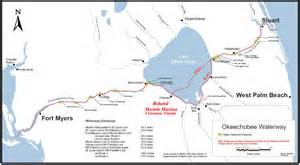
It is interesting to note that the “Stuart to Ft Meyers Cross-State Canal” must  later have become known as the “Okeechobee Waterway:”

WIKI: https://en.wikipedia.org/wiki/Okeechobee_Waterway

Although this celebration was about the benefits of navigation, Edwin Menninger on the front of the 1937 historic edition wrote:

“Construction of the St Lucie Canal began in 1921 when the fact dawned on the Everglades pioneers that canals through muck lands were useless – they refused to carry water out of the lake. Four of them had been dug, and were utterly worthless. The St Lucie was completed in 1924 and for 13 years has been the only functioning outlet from Lake Okeechobee to the sea.”

So perhaps the opening of the cross-state canal in 1937 was the beginning of “shared adversity” or shared destruction of the two coasts as it was not until 1937, after great investment by the Federal Government, that the Caloosahatchee River finally had a “navigable channel 7 feet deep and 80 feet wide,” before that it was very limited.

Considering that today the poor Caloosahatchee takes about two-thirds of the water drained from Lake O, we here on the east coast have to consider the possibility that if the “improvements” of the 1937 cross state canal were not done, the St Lucie might still be taking 100% of Lake O’s drainage water!

(Caloosahatchee And Its Watershed, FAU 1998, outstanding time-line, see pages 5-11 or vi-xii http://www.ces.fau.edu/publications/pdfs/the-caloosahatchee-river-and-itswatershed.pdf)

In 2009 my husband Ed and I took the our dogs Bo and Baron along the cross-state canal trip from Stuart to Ft Meyers, but stopped in Lake Okeechobee. Lots of storms! It was insightful and fun. One day I do hope to go all the way to Ft Meyers. This is definitely a “Florida bucket-list to do!”

Ed, Bo and Baron ~St Lucie River on way to Lake O – Cross State Canal trip 2009.

Video of Ed my 2009 trip cross state canal to Lake O: https://www.youtube.com/watch?v=A8fyYCw6aW4&feature=em-share_video_user)

“Stuart on the St Lucie,” Real Estate History and the Cluelessness of Developers Regarding the Health of the Indian River Lagoon

St Lucie Estates, On the Beautiful St Lucie River, Stuart Florida, 1926 booklet. (St Lucie Estates, Inc.)
St Lucie Estates, On the Beautiful St Lucie River, Stuart, Florida, 1926 booklet. (St Lucie Estates, Inc.)

In the 1960s, I grew up in St Lucie Estates, Stuart, Florida, the neighborhood just north and south of Kreugar Creek close to the St Lucie River, not too far from Downtown Stuart. Until I was ten, we lived at 109 Edgewood Drive. I loved that little brick house. I had full reign over the neighboring empty lots and could ride my bike on the “black road,” to get to a park, along  the river, next to the Granfield’s house. The kids of the neighborhood often met there, and we pretended the gigantic, falling Australian Pine was a ship and we made it into our fort. We traveled across oceans. We fought pirates. It was a wonderful childhood.

As a kid, I had no idea of the long running issues with the St Lucie River/Indian River Lagoon, the canals, and Lake Okeechobee. I just knew I loved the river. I loved that I could escape there. Even when I was in high school, living in Sewall’s Point, I’d steal away and sit under the bridges and “think” in the privacy of the river’s ancient calm.

Today, at half a century, I am still in love with the river, but I view it in a different light. A light of history and destruction. My heart aches because I really don’t know if it can make it against the odds. Now that I am older, I know its complete destruction has been coming for a long time, kind of like a cancer. I am miffed that since 1923, when the ACOE first connected the C-44 to the South Fork of the St Luice, that locals were not able to stop the “drainage machine,” as Ernie Lyons, previous editor of the Stuart News, called it. I am miffed also that the state and federal agencies would so blatantly kill an ecosystem.

When I look through my mother’s historical data and read the ads for selling land in Stuart in the early 1900s, it is ironic that they all incorporate the St Lucie River into their sell while they were killing her.

“Stuart on the St Lucie, 1907;” “St Luice Estates, On the Beautiful St Lucie River, 1926;” “Stuart, Atlantic Gateway to the Gulf of Mexico, ca. 1926.”

The are all bragging about draining the Everglades; they are bragging about the digging of the Okeechobee Waterway from Stuart to Ft Meyers thorough Lake Okeechobee; they are basing the draw of the Stuart area on its  location/proximity to the St Lucie River/Indian River Lagoon, and yet they seem to have no clue that by supporting the over draining and over dredging of everything, they have created the rivers’ own destruction!

All news adds and photos from Stuart on the St Lucie, by Sandra Henderson Thurlow, 2001)
All news ads and photos from Stuart on the St Lucie, by Sandra Henderson Thurlow, 2001)

IMG_5887 IMG_5882 IMG_5883;IMG_5877 IMG_5884

This is an excerpt from the St Lucie Estates sales booklet:

” St Lucie Estates is situated in one of the most gorgeous spots in Florida—the beautiful St Lucie River County…The St Lucie and the Indian River meet here to form one of the most wonderful bodies of water in the world—one hundred miles of navigable waterway,  edged with luxurious tropical foliage able white sandy beaches…”

“In the introduction to my mother’s book, Stuart on the St Lucie, she writes” Pioneer businessmen of Stuart…realized the St Lucie River was the town’s greatest asset. To foster awareness they of the town’s superior location, they used “Stuart on the St Lucie” in promotional literature, on signs and as newspaper headings. Time has not changed the fact that the St Lucie River is the best thing about Stuart.”

Promotional signs to "Stuart on the St Lucie"  along Dixie Highway from Jacksonville read as shown on list and stated, ca. 1919. (SHT)
Promotional signs to “Stuart on the St Lucie” along Dixie Highway from Jacksonville read as shown on list and stated, ca. 1919. (SHT).

The St Lucie is still the best thing about Stuart, and now we know better. The drainage of lands surrounding the St Lucie/IRL was too extensive. In order to make way for agriculture and real estate development.  The St Lucie River and Indian River Lagoon now take on more than twice what was originally drained into them. 

The excess fresh water and pollutants have all but killed the St Lucie River/Indian River Lagoon. This chart shows the original drainage in green and today’s drainage which has been added to the green area  in yellow. Lake Okeechobee’s  discharges, in pink, are often on top of this. It is too much.

The old adage says “history repeats itself.” Well, here in “Stuart on the St Lucie,” history cannot repeat itself anymore. We must create a new future.

Drainage changes to the SLR.
Drainage changes to the SLR 1900s to today.(Citizen’s Report to Congress, 1995)


Florida Inland Navigation District, F.I.N.D., Maintaining the Okeechobee/Atlantic Waterways of the St Lucie River/Indian River Lagoon

The Okeechobee Waterway or Cross State Canal is managed through a partnership of  F.I.N.D.and the US government.
Parts of the Okeechobee Waterway or Cross State Canal, (partially C-44), is managed through a partnership of F.I.N.D.and the U.S. government, ACOE. (Photo Jacqui Thurlow-Lippisch, 2009.)

The Intracoastal and Okeechobee Waterways are important navigation channels and part of our country’s heritage.

Atlantic Intercoastal Waterway from Maine to South Floida. (Map, public.)
Atlantic Intracoastal Waterway from Maine to South Floida. (Map, public.)


Okeechobee Waterway from Atlantic to Gulf of Mexico. (Map, public)

The history of navigation in the United States is a long one that is difficult to put into perspective within the context of today’s modern world. Military, commercial and communication centers were imperative goals to the newly established United States and remain so today, but these things are now taken for granted and have also inadvertently caused massive environmental destruction.

The Atlantic Intracoastal Waterway is a 3000 mile inland waterway along the east coast of the US from Maine to Florida. The Okeechobee Waterway is a few hundred miles across the state, from Stuart to Ft Meyers, linking the Atlantic to the Gulf of Mexico through canals and Lake Okeechobee.

These canals are directly supported by the public though a tax.  If you look at your tax bill you will notice you are charged a .3045 mill to maintain the Florida Atlantic and Okeechobee Intracoastal Waterways. After a long evolution, today, the state’s Florida Inland Navigational District or FIND is the entity that acts in cooperation with the US Government, Army Corp of Engineers,  to oversee these tax funds in order to maintain these important canals that serve many purposes.  Some we don’t like…

One of the purposes of the Okeechobee Canal, built in the late 1920s and “improved” many times since, by being deepened and widened,  is to release water from Lake Okeechobee into the St Lucie River/Indian River Lagoon when Lake Okeechobee gets too full, as the lake  has been diked for the safety of agricultural lands and urban communities living around and south of the lake.

The mission of FIND is very broad actually; if we look at the mission statement of FIND it reads:

“The Florida Inland Navigation District has two primary missions: (1) to perform the functions of the “local sponsor” of the Atlantic Intracoastal Waterway project and a portion of the Okeechobee Waterway project in Florida, both of which are State/Federal navigation projects, and (2) provide assistance to other governments to develop waterway access and improvement projects. As the local sponsor of the Waterway, the District provides all lands required for the navigation project including rights of way and lands for the management of dredged materials removed from the waterway channel during dredging activities.”(http://aicw.org/index.jsp)

FIND is overseen by commissioners from the twelve counties along Florida’s east coast. Commissioners are appointed by the Governor and approved by the Senate. Our local commissioner is friendly and well known,  Mr Don Cuozzo.

Don Cuozzo
Don Cuozzo

FIND also serves other purposes very close to the people and local communities that I do care about, such as providing grant funding for local waterways improvements, and maintaining the important manatee signage and protection zones. We all know this iconic and endanger species, a gentle, distant relative of the elephant, is often stuck by speeding boaters.

Award winning photo seen in National Geographic story on south Florida waters.
Award winning photo seen in National Geographic story on south Florida waters, 2012.) (Photo by Paul Niklin, friend of Nichole Mader.)

Thank you to FIND, but it sure would be nice if we could FIND another way to for the lake’s water to go than through the St Lucie/Indian River Lagoon.

For 2013, Ed and I paid $13.31 to FIND. Although I would prefer not to support the Okeechobee Waterway atrocity, I do like manatees, boating, and the Town of Sewall’s Point has benefited from FIND grant programs as well.  So, I guess, for now, Ed and I  will pay the tax; but one day, I have the feeling, I might just rebel!

_______________________________________________________

Atlantic Intercoastal Waterway (http://en.wikipedia.org/wiki/Atlantic_Intracoastal_Waterway) 

Okeechobee Waterway, ACOE: (http://www.saj.usace.army.mil/Missions/CivilWorks/LakeOkeechobee/OkeechobeeWaterway(OWW).aspx )