-Photo credit: Martin County: Chair Martin County Commission, Stacey Heatherington in red, and SFWMD Governing Board, ribbon-cutting Allapattah Flats 1-21-21
 Yesterday, the South Florida Water Management District held a ribbon-cutting for Allapattah Flats. The celebration was for over 6000 acres of wetland restoration work completed through a partnership: specifically the South Florida Water Management Distirct, the Natural Resources Conservation Service, a division of the U.S. Department of Agriculture, and Martin County who for a over a generation has provided leadership for natural land purchases.
 As this recent op-ed of longtime Martin County Commissioner, Mrs Maggy Hurchalla states, bringing back wetlands is the most on the ground, real way to restore the Everglades. This means the St Lucie River too. The beautiful bird life really appreciates this as post drainage, due to habitat destruction of wetlands, their numbers plummeted by the millions.
-Photo credit SFMWD: a juvenile little blue heron is released by Bush Wildlife Center!  -Renewed Partnerships: Rep. John Snyder; SFWWMD, JTL; MC Chair Stacy Heatherington; Comr. Doug Smith
  -JTL, MC Comr. Sarah Heard
 -SFWMD Executive Director, Drew Bartlett, JTL, & Mr. Jaun Hernandes, NRCS
 So what was Allapattah Flats?
Since drainage, the lands, flora, and fauna have changed so much! It’s almost unrecognizable. To get a good idea of what it used to be, so as to understand the ribbon- cutting within the context of toady and yesterday, I knew if I was to well prepared for the event, I had to inquire with my history and map loving brother, Todd Thurlow. I am including Todd and my correspondence on this issue because it is so interesting and helpful in understanding “what is, what was, Allapattah Flats”. Our email exchange is below:
J: “Todd tomorrow is the ribbon-cutting for Allapattah Flats. Was Allapattah Flats part of the Alipatiokee Swamp or was it separate? Was it a pine flatwoods area with small marshes or what. All these historic names sound the same. – Allapattah, Halpatiokee, Alpatiokee. I’m looking at that 1839 Gen. Z. Taylor map. Thanks.”
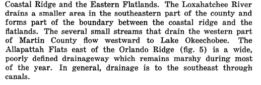
 Above: portion of 1839 Gen. Zachary Taylor map. Allapattah and derivatives mean “Alligator” in Seminole.
Below: portion of “old” Florida map- one can see the former extent and connection of Allapattah Flats running along the inner east coast that the C-44 /St Lucie Canal from Lake Okeechobee to South Fork of St Lucie dissects. Shared by Todd Thurlow.
T: “I think Allapattah Flats is one of those names that has moved around/changed over the years. It’s the old Al-pa-ti-o-kee Swamp of my YouTube Video. It was a wetland. Not a pine forest. It may have become a pine forest after it was drained – or had pine forests at its edges like the Savannas in Jensen.
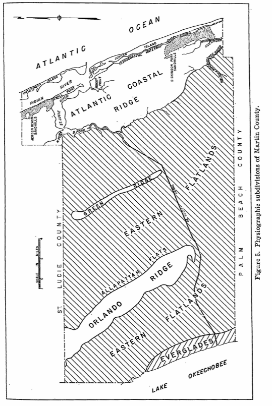
I think of it as the area west of Green Ridge and East of the Orlando Ridge. I don’t think it was called Flats because of the pine flatlands. I think the name may have come from the fact that it was flat – water would slowly flow north OR south in the poorly drained marsh depending on the conditions at the time. The excepts below speak of it including the Hungry Land Slough or being a slough itself. The first reference shows it immediately east of the Orlando Ridge. But the Al-pa-ti-o-kee was the entire area.”
- Florida Geological Survey Report of Investigations no. 23 – May 16, 1960


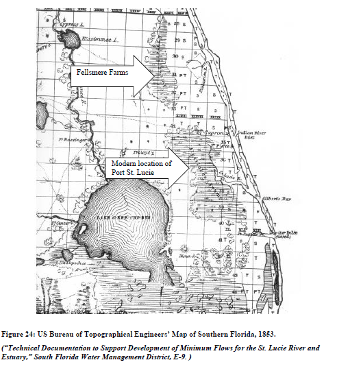
2. Oranges and Inlets – Nathaniel Osborn 2012. As the wetlands of the IRL were drained, the names of land features shifted over the decades to reflect their changing form. Today’s “Allapattah Flats” near the St. Lucie Estuary is undoubtedly a post-drainage name for the same feature listed on nineteenth century maps as “Halpatta Swamp” or “Alpatiokee Swamp,” but the lowered water table has left the area no longer resembling wetlands. Surveys of the lands west of the St. Lucie Estuary in the decade before the completion of the St. Lucie-Okeechobee Canal suggest that the land was covered with standing water for 8-10 months of each year. In the years which followed the post-1916 Drainage Act canalization, this drained region (like much of the IRL) became citrus groves, the town of Palm City, and the post-World War II development of Port St. Lucie (figure 24).273
 ————————————————————-
3. Bill Lyons, son of Ernie Lyons, from your blog. “During summer, sheet-flow from the Allapattah Flats converged in tiny rivulets into a deep pool with a sand bottom, the first of a series of pools connected by shallow streams of clear water that formed the headwaters of the South Fork. Dad loved that place, not just for its beauty but for its solitude. Itcould only be reached by Jeep during the wet season, so we hitched rides with the local game warden, who would drop us o and return for us later. Clyde Butcher’s photos of the upper Loxahatchee River are the nearest thing I’ve seen to what once was the upper South Fork. Then in the fifties, construction of the FloridaTurnpike cut off the flow of freshwater to the River. Soon saltwater intrusion crept up the South Fork,impeding the spawning of its fish, and the River began to die. In 1962, a friend and I drove to the former siteof the headwaters. The area had been bulldozed and the pool had become a cattle watering hole.”
4. Florida Everglades Report 1913 – Document 379, 63d Congress, 2d session 
5. The New York Botanical Garden – Green Deserts and Dead Gardens, A Record of Exploration in Florida in the Spring of 1921
J: Todd this is incredible. Thank you!
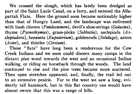
6. One more reference from The New York Botanical Garden, Old Trails and New Discoveries, A Record of Exploration in Florida in the Spring of 1919. It is pretty descriptive. Hungry Land – southeast / Allapattah Flats northwest.This is the kind of stuff I love reading because you know what he is describing. He describes the “distant pine wood towards the west” and a long evident tall hammock … one would have almost sworn … was a range of hills”. He is looking at the Orlando Ridge, the southern tip of which is Indiantown. You can still see what he sees when driving west on SR 70 or the stretch of turnpike that goes west though St. Lucie County.


 J: So Todd, it sounds they drained Allapattah Flats and Hungry Land Slough in the 20s when they dredged the St Lucie Canal from Lake Okeechobee to the St Lucie River. What a bargain! Aggg! Thank God we are bringing some of it back! See you tomorrow!
Released juvenile little blue heron in wetlands Allapattah Flat, photo Todd Thurlow So as you can see what is, what was Allapattah Flats is a long story! And we began to restore history!
Todd’s pictures: http://www.thethurlows.com/2021-01-21_AllapattahFlatsRibbonCutting/
Jacqui’s speech: https://www.youtube.com/watch?v=AuklcguRVgY&feature=youtu.be
The official SFWMD stream: https://www.youtube.com/watch?v=hg5MksxMbX0