Tag Archives: Jacqui Thurlow-Lippisch

History of the River Movement; the Tipping Point, It’s Coming, St Lucie/Indian River Lagoon

St Lucie River Initiative's Report to Congress 1995, and River Dayz '96 Festival. (Courtesy of historian Sandra Henderson Thurlow.)
St Lucie River Initiative’s Report to Congress 1995; River Dayz ’96 Festival booklet; and historic newspaper info in this article courtesy of historian Sandra Henderson Thurlow.

A woman’s right to vote did not come come in a day; stopping the horrors of slavery in the Untied States took a civil war and the life of one of our greatest presidents; most recently, we are seeing a revolution in gay rights.

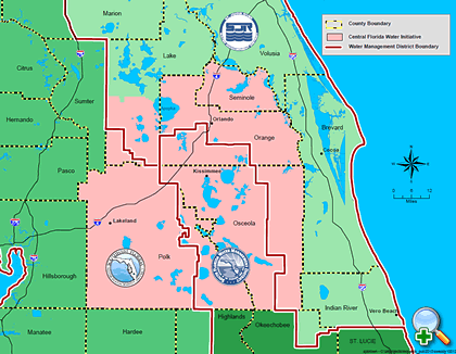
These movements take time, but eventually, there is tipping point were things begin to change direction. As we know, our river movement has been going for almost 85 years as the first time the Martin County commission asked the ACOE to stop releasing Lake Okeechobee water into the St Lucie River was documented in their minutes of  1930.

1930 request of the MCBOCC for the ACOE to halt releases from Lake O to SLR.

Today I wanted to encourage you not to feel discouraged that the St Lucie Indian River Lagoon movement has been going on so long, but to feel empowered that you are part of something that is big, that takes years, and has a moral element to it just like human rights. This moral element is what in time will force the State of Florida and the United States of America to scrutinize our destructive drainage practices of the past.

As it says in our Declaration of Independence:  When in the Course of human events, it becomes necessary for one people to dissolve the political bands which have connected them with another, and to assume among the powers of the earth, the separate and equal station to which the Laws of Nature and of Nature’s God entitle them, a decent respect to the opinions of mankind requires they should declare the cause which impels them to the separation.

For me, this document gives permission to pull away when necessary. We are and have been pulling away. We envision something better and we are willing to fight for it. Just for the record, some of those before us include:

1. Commercial fishermen in 1925, two years after the canal opened in 1923, in the newspaper of the day, The Florida Developer fought the destructive abundance of fresh water from the lake.

2. A 1931 article from  The Florida Developer’s editorial team notes it was “critical” that the releases from Lake Okeechobee be stopped.

3. 1945 another paper, The Stuart Messenger notes that the river had turned into a “mud soup,” killing fishing; tourism; and real estate.

4. 1958 local citizens filled the Martin County Courthouse to discuss with a delegation of the Flood Control District and the Army Corps of Engineers the possibility of a third outlet from Lake Okeechobee. Although hopes were high, nothing  materialized.

5. Editor, and writer for the Stuart News, Ernest Lyons (1931-1974) wrote many award-winning articles against over canalization in our area of not only C-44 from Lake Okeechobee but also  C-23, C-24 and C-25 further north that drained even more polluted fresh water into the rivers. His newspaper/writing career continued for many years.

6. In the early 1950s the Izzak Walton Group; the Martin County Conservation Committee and the St  Lucie- Indian Rivers Rivers Restoration League all fought for the river even garnering meetings with top government officials. Apparently the ACOE met with locals and a report was done “but nothing ever happened…”

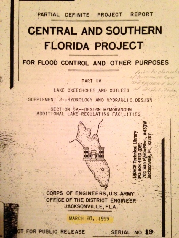
7.  In 1990 Ernest Lyons, who had been prominent in all groups  listed in #6, died:  to fill that void, “Leadership Martin County” in 1992 , with the help of Mr Bud Jordan, Kevin Henderson and Tim Kinane, founded the St Lucie River initiative whose report to Congress is today’s blog photo. Their “River Dayz Festival” on behalf of the river brought hundreds together, they created river materials for elementary, middle and high school students, focused on muck removal and business support.

8. In 1993 the Greater Martin County Board of Realtors joined in its support of the St Lucie River/Indian River Lagoon, sending out a letter stating that the organization had joined the St Lucie River Initiative and encouraged a “call to action to contribute to the organization and to write letters to government officials.”

9. In 1998, after the worst toxic algae bloom and fish kill/fish lesion outbreak ever documented in Martin County during heavy  releases from Lake Okeechobee, the Rivers Coalition came into being unifying businesses and an education program as well as developing the Rivers Coalition Defense Fund set up to sue the Federal Government and others on behalf of the St Lucie River/Indian River Lagoon. Realtor Leon Abood, became the longstanding and outspoken chair.

10. On December 4th, 2010, a Rivers Coalition Lawsuit against the Federal Government was heard in the Court of Federal Claims in Washington DC. According to edited words of Karl Wickstrom, chair of the Defense Fund at that time, U.S. District Judge Lynn Bush wrote in her explanation:

“The St. Lucie River is by all accounts, a national treasure. The longterm environmental consequences of defendant’s,  U.S. Army Corps of Engineers,’ massive discharges into the river are tragic, and the court takes note of plaintiffs’ tireless efforts to reverse that damage.”

The court ruled that a remedy to stop the harmful discharges must come not from the courts but from Congress; she dismissed the case, but it garnered national attention and moved issues of the river forward.

11. In 2011 the River Kidz were born of two 5th grade girls and became a division of the Rivers Coalition. They held two river rallies at the St Lucie Locks and Dam in 2012 during discharges from Lake Okeechobee. Senator Joe Negron, Chairwoman Sarah Heard, and other politicians mingled with parents looking for a way to deal with the discharges. Congressman Patrick Murphy later also supported the Kidz in their efforts. The key: parental involvement and youth.

12. 2009-2011, going public in 2012/13, it was realized a that a super bloom and brown tide algae bloom had killed 60% of the seagrasses in the northern and central IRL. Unusual Mortality Events (UMEs), declared by NOAA, followed for both endangered manatees and the protected bottle nosed dolphins. Hundreds of pelicans also died.  This galvanized the counties of the IRL, southern, central and northern alike.

13. 2013, the ACOE starts releasing from Lake Okeechobee May 8th until October 21st. This time becomes the “Lost Summer,” toxic conditions ensue. Young Evan Millar and Clint Starling and others call for a rally at the locks on Facebook. Over 5000 show up. Beach rally later brings over 2000. Hands Across the Lagoon unifies thousands across the 156 mile lagoon as well.  The STUART NEWS/SCRIPPS NEWSPAPERS starts a river news campaign that has educated thousands and is still going today. St Lucie County as well as Lee County River Kidz is born…

14. 2013 the Sugarland Rally in Clewiston; Senator Negron’s Senate Hearing on the Indian River Lagoon and Lake Okeechobee Basin;  Congressman Murphy invites the state and local officials, the River Warriors, and River Kidz  to to a meeting on the Indian River Lagoon and Lake O.  in Washington DC. …..Commissioner Ed Fielding forms the Indian River lagoon County Collaborative unifying all counties along the lagoon. (Palm Bach quits.)

15. In 2014 the fight has continued. The pressure has not let up. Presently the University of Florida is studying the issue of “sending water south…”

16. 2014,  last week, the South Florida Water Management District and Dept of Environmental Protection and others recommend against Sugar Hill, a proposed development in Hendry County on option lands, most designated for Everglades restoration or trading.

It has been a long journey, but I am confident that the tipping point is coming. We have over drained our lands, we have destroyed our rivers and lakes, we are wasting 1.7 billion gallons of fresh a day to tide knowing we have a growning population coming…

If nothing else, it will be the need for fresh water and the knowledge that wasting it is wrong that will  in the future push the St Lucie/Indian River Lagoon movement tipping over the edge…


A Surprise Visit by Gubernatorial Candidate, Charlie Crist, St Lucie River/Indian River Lagoon

Charlie Crist visits the St Lucie River/Indian River Lagoon October 3, 2014. Photo by Jacqui Thurlow-Lippisch.)
Charlie Crist visits the St Lucie River/Indian River Lagoon October 3, 2014. (Photo by Jacqui Thurlow-Lippisch.)

As you probably saw in the paper, Charlie Crist, Democratic gubernatorial candidate for Florida, visited Stuart on Wednesday, October 3, 2014. Very exciting! I have been waiting for the governor’s race to crank up and for the St Lucie River/Indian River Lagoon to be in the spotlight as it should be.

In my dream of dreams Governor Scott and Charlie Crist would come to Stuart debate. For now, I will be satisfied that this year both have visited and spoken and are aware of health issues facing the St Lucie River/Indian River Lagoon.

I had seen Charlie Crist speak before at the Florida League of Cites, in Hollywood, but it was fun to see “the man, the myth,” our former governor, up close, face to face, along with his beautiful wife Carol.

I shall tell you of my short experience…

As I did not learn of the visit until the day before, I already had commitments and thus was one hour and a half late to Mr Crist’s planned arrival to tour the lagoon at the invitation of Marty Baum, Indian Riverkeeper.

This was inconsequential as the Crist team was late itself, so when I arrived at Sandsprit Park, Mr Crist and his team had just gone out in the boat with Marty Baum, Mark Perry of Florida Oceanographic, and others.

Coming in off the boat
Coming in off the boat.
Marty Baum, Indian Riverkeeper, Kevin Stinnet, and
Marty Baum and friends.

As Mr Crist came off the boat I moved to greet him and grabbed his hand to help him onto the dock.  I thanked him for his visit. His wife, Carol was at his side holding a sign that read,  A FAIR CHANCE FOR FLORIDA.  I knew that the couple had married in 2008 and that she was a very successful business woman who ran the  family business, Franco American Novelty Co . and was most well-known for  inventing  the slogan: “Where Fashion Meets Halloween,” and  creating  sexy Halloween costumes that were big sellers. She is a talented marketer.

I wondered what she thought so far of Stuart. She smiled, stepping off the boat in high heels.

Charlie Christ's wife, Carol, was at his side on the boat ride. (Public photo)
Charlie Christ’s wife, Carol, was at his side on the boat ride. (Public photo)

Once off the boat they got their sea legs as apparently a big wave had hit…the small crowd loved him and gathered around.

Mr Crist composed himself, a calm and confident speaker. This was obviously a man used to being in the public eye.

The questions from the reporters about the lagoon were many, and Mr Crist did a good job answering. Nonetheless there was an awkward moment that must be noted.

Tyler Treadway from the Stuart News asked Mr Crist about how he would stop the discharges from Lake Okeechobee and Mr Crist answered that “he would put the right people on the South Florida Water Management Board and the discharges would stop; like they did before, when he was governor…”

There was silence. Tyler’s lips quivered; he said something like …”Sir I don’t know how you can say that? …That you stopped the discharges….”

Charlie Crist repeated again that he had.

I watched this crowd who adored and appreciated Mr Crist but they were too educated and too far into this not to know that stopping the discharges is a lot more complicated that that….and that they have NEVER stopped for long.

The was the pregnant pause….Silence….Tyler looked at his writing pad….the crowd stared into space.

As usual I could not stop myself and I finally blurted out: “Temporarily…..”

Charlie Crist looked straight at me; I respectfully held my gaze, head slightly down.

We all looked at each other….and stared. It was time to go.

We all thanked him. It was a great visit.

I believe Mr Crist’s intentions are good, I just don’t think, he like all politicians, is  used to speaking to such an educated public.

We know the truth, we need a third outlet from the lake and other water holding areas, there are no saviors, no boards that will fix our terrible St Lucie River/Indian River Lagoon/Lake Okeechobee problem.

“Why didn’t he speak about his US Sugar buyout plan from 2008?” Said someone as we were all walking away?

“He didn’t know who he was taking to,” I answered. “The most educated public in the state. Politicians are not used to that…”

We waved goodbye. And Charlie flashed us that winning smile. We hope he’ll come again.

Pam Joy hold a sign SAVE OUR RIVER.
SAVE US
SAVE US
St Lucie River Kidz were there to meet Charlie Crist. Their mission is to speak out, get involved and raise awareness....
St Lucie River Kidz were there to meet Charlie Crist. Their mission is to speak out, get involved and raise awareness….


Aerial Photos: SugarHill-Sector Lands, Restoration, Indian River Lagoon

A view from Airglades Airport looking southerly. Photo Ed Lippisch, 9-14)
A view from Airglades Airport, the business center of proposed US Sugar’s “SugarHill” development,  looking southerly into a horizon of agricultural lands. (All photo by Ed Lippisch, 9-27-14)

(* I have just realized the photo above is the old Clewiston Airport not Airglades. Here is one of Airglades from http://www.airnav.com/airport/2IS.   JTL 9:30 AM.)

Airglades Airport, photo Wikipedia.
Airglades Airport, photo AirNAv.

The flight last weekend: Stuart to Clewiston…

I could not be a passenger, it was too windy and I knew I would be sick hanging my head over the edge of the Cub. It has happened before.

In the yellow Piper Cub, the fight to Clewiston from the St Lucie River/Indian River Lagoon, in Stuart, is about 45 minutes one way, a long time if the air becomes a rough ocean.

Approaching Clewiston from the east.

So my husband, Ed flew alone and sent me a few photos along the way. He will do anything to get  up in that airplane. For him it is fun even if it is windy.

So let’s take a closer look where Ed flew, to that area we all keep taking about in Hendry County and proposed first by US Sugar Corporation: SugarHill.

As one can see from the map below, Airglades Airport is west of Clewiston close to where Highway 27 shoots north.  The SugarHill sector plan land use change encompasses a tremendous amount of land, 44,000 acres, these  lands are located where the state has an option to buy for Everglades restoration.  If some of those lands get zoned for residential and commercial development it could complicate trying to send water south through trading these lands or using them for restoration in the future. That’s why we want to take a look.

Location of Airglades Airport, Google Maps, 2014.
Sugar Hill proposal, 2014.
A view from Airglades.
A view from Airglades Airport, (same photo as above) shows runway on right, development on left, and miles and miles of surrounding agricultural lands.
Agricultural lands.
Agricultural lands.
Agricultural lands.
Agricultural lands.
Agricultural lands land canal.
More agricultural lands and canal.
Very north west over what was once Lake Hipochee.
Very north-west over what was once Lake Hipochee, headwaters of the Caloosahatechee.
Flying back to Stuart looking back to Clewisotn.
Flying back to Stuart looking back to Clewiston.

So basically the SugarHill sector lands are west of Clewiston, there is an airport, some development and miles and miles of agriculture. What is shall become only time will tell. I hope now that you’ve had a look, it will be easier for you to make a decision to protect these lands for the Everglades, St Lucie River and Indian River Lagoon.

__________________________________

Article 360: (http://www.law360.com/articles/579122/us-sugar-s-plan-could-bog-down-everglades-restoration) 


The River Doesn’t Belong to a Political Party; It Belongs to All of Us, St Lucie River/Indian River Lagoon

A newly elected Congressman Partick Murphy holding recycled FDOT signs painted by the River Kidz. The flag sign was taken to Washington DC and displayed in the front office, 2012.
Newly elected Congressman Partick Murphy holding recycled FDOT signs painted by the River Kidz. The flag sign was taken to Washington DC and displayed in the front office, 2012.

I support politicians that work in the interests of the St Lucie River/Indian River Lagoon. The river doesn’t belong to a political party; it belongs to all of us.

The St Lucie River/Indian River Lagoon doesn't belong to a political party; it belongs to all of us.
Image 2014, bullsugar.org.

Just over a month ago, I wrote a blog entitled, “Why I Support Senator Joe Negron,” a Republican, (http://jacquithurlowlippisch.com/2014/08/26/why-i-am-such-a-big-supporter-of-senator-joe-negron-indian-river-lagoon/),  and today I am writing in support of Congressman Patrick Murphy, a Democrat.

I am a registered republican.

To me, people are more important than their political affiliations.

From the beginning Patrick Murphy displayed that he wanted to work with everyone. After winning Florida US House District 18, he came to Martin County and met with leaders of all municipalities and the county, together.  He introduced  himself and ask us what issues were most important to us. The health of the St Lucie River/Indian River Lagoon was the top agreed choice and Patrick got to work.

Looking back, little things say a lot.

I recall I was impressed that he wasn’t afraid to get his “hands dirty.” He immediately participated in an oyster restoration event in Ft Pierce with St Lucie County Commissioner, Chris Dzadovsky. Dzadovsky ended up suffering from a skin infection due to an oyster cut during the oyster deployment….Congressman Murphy quickly caught on to the seriousness and the extent of the Martin, St Lucie river problem and how much the river’s improvement meant to the local people.

Another plus for me was that he quickly befriended the River Kidz and took their call for “getting involved, speaking out, and raising awareness”seriously. Some members even went to Washington DC to participate in his IRL meeting with congressional leaders. Now that’s a first!

Patrick’s list of accomplishments is broad including pushing hard for monies for the C-44 Storm Water Treatment and Reservoir for C-44 basin runoff; and CEPP, the Central Everglades Planning Project that if ever approved will divert about 12% of Lake Okeechobee’s water south, and monies for the National Estuary Program’s revamping. The list goes on, please see image below.

Flyer on front desk inPatrick Murph's Stuart office.
Flyer of Murphy’s IRL “Action and Advocacy.”(Click to enlarge.)
Side 2 of flyer
Side two of flyer.
Congressman Murphy in Washington DC with River Warriors, River Kidz and others, for session on IRL., 2013. (Photo Nicole Mader.)
Congressman Murphy in Washington DC with River Warriors, River Kidz and commissioners, and others, for session on IRL.  In spite of a government shutdown,  many congressional leaders met with the group. (Photo Nicole Mader, 2013.)

I know over time there is a lot more to do. But the young congressman is off to a great start and most important, we have developed a relationship with him. We must keep this relationships going.  For in the end, no political party will save the river; it is only people and their relationships that can do that. 

Patrick at fundraiser held in the Town of Sewall's Point, 2013.
Patrick at fundraiser held in the Town of Sewall’s Point by Karen Cahan. Sewall’s Point is known as a “republican enclave,”  2013.
Speaking on behalf of Congressman Murphy at his campaign headquarter in Stuart, 2014.

_______________________________________

Campaign commercials I have done in support of Congressman Patrick Murphy, Democrat and Senator Joe Negron, Republican, 2014.

Congressman Patrick Murphy commercial IRL: (https://www.youtube.com/watch?v=SdODyl-tFE0&feature=youtu.be)

Senator Joe Negron commercial IRL(https://www.youtube.com/watch?v=lLDSi4EsPJU)

The Nuns of the Indian River Lagoon

The nuns of Mount Elizabeth, St Joseph's College, 1964. (Photo Aurthur Ruhnke, Thurlow Historic Archives.)
The nuns of Mount Elizabeth, St Joseph’s College, 1964. (Photo Aurthur Ruhnke, Thurlow photo archives.)

In the 1960s and 70s, when I was a kid sitting in my parents’ car, watching the world go by,  I often saw a sight along Indian River Drive that even today, I can clearly bring into my mind’s eye: the nuns of the Indian River Lagoon.

It was a striking image for a child. The nuns in their black veils in the 90 degrees weather walking in unison under the royal palms, the sparkling river in the background…

St Joseph’s College was founded in 1890 and the branch that was located at today’s Indian Riverside Park, along the Indian River, opened in 1966.

The story of how the nuns got there is a rather ironic one, and today I will share this story.

First let’s set the stage…

The lands where the nuns lived was originally an ancient Indian burial mound, and in 1855 was included in the 100 acres of land purchased by wealthy gentleman, Henry William  Racey whose son Charles Henry Racey eventually built a beautiful home atop the 4000 year old Indian mound; the site became known as “Mount Elizabeth,” shown below.

The Racey home on Mount Elizabeth, ca. 1892. (Photo courtesy of Thurlow photo archives.)

Later, the property was purchased by Judge Edward Swann, and next in 1936, by Coca-Cola heiress  Anne Bates Leach and her husband Willaford. Their home was named “Tuckahoe,” or “welcome” in the ancient tongue of the once proud and strong  native peoples. The estate was spectacular, as seen below.

The Leach Estate, Tuckahoe, 1948. (Photo Aurthur Ruhnke, Thurlow photo archives)
The Leach Estate, Tuckahoe, 1948. (Photo Aurthur Ruhnke, Thurlow photo archives.)

During the 1940s, the Martin County Commission had “allowed” Francis Langford and her husband to dredge a marina and construct tourist cottages on their property immediately south of the Leach estate and “tourist camps” had sprung up along the Indian River shoreline from Jensen Beach to the northern boundary of Tuckahoe.

According to Sandra Henderson Thurlow’s book “Sewall’s Point, A History of a Peninsular Community on Florida’s Treasure Coast,”

“The Leaches felt that the value of their property was greatly diminished and they were infuriated when the county refused to lower their taxes. To “get even” they vowed to sell their property to an organization with a tax-exempt status…”

which they did….

The property was sold to the Catholic Church for $75,000 and in 1950 the estate became a novitiate for the Sisters of St Joseph. 🙂

Nuns in front of the former Leach mansion, Tuckahoe.
Nuns in front of the former Leach mansion, now with dormitories, Tuckahoe. (Photo Aurthur Ruhnke, Thurlow photo archives.)

As we know, the campus of St Joseph eventually became the Florida Institute of Technology, a school that has created many of our local ecologically minded business leaders. After hard financial times the institute closed in 1986, and sat deserted for many years.

Then, through the very hard of work of a “redeemed Martin County Commission,” the land blossomed into “Indian Riverside Park,” a gem of our Treasure Coast.

When one looks at the history of the property, it is hard not feel like somehow, we’ve been blessed.

Tuckahoe today is a popular site for weddings and meetings. (Photo Jacqui Thurlow-Lippisch, 2014.)
Tuckahoe today is a popular site for weddings and meetings. (All photo by Jacqui Thurlow-Lippisch, 2014.)
Oyster and clam shells thousands of years old form the mound, the "mount" of Tuckahoe.
Oyster and clam shells thousands of years old form the mound, the “mount” of Tuckahoe.
View along the boardwalk of Tuckahoe.
Historic marker for Mount Elizabeth.
Historic marker for Mount Elizabeth, telling the story of the Ais Indians,   Riverside Park.

_______________________________________________

Tuckahoe, Martin County Commission: (http://www.martin.fl.us/portal/page?_pageid=354,4190284&_dad=portal&_schema=PORTAL

Florida Institute or Technology and St Josephs College link/Wikipedia:  (http://en.wikipedia.org/wiki/Florida_Institute_of_Technology_(Jensen_Beach_Campus))

The Governor’s Grave Along the Indian River Lagoon

Palms Cemetery lies along the beautiful Indian River Lagoon at 7201 South Indian River Drive, Ankona. (Photo Jacqui Thurlow-Lippisch 2014.)
“Palms Cemetery” lies along the beautiful Indian River Lagoon at 7201 South Indian River Drive, Ankona. (All photos by Jacqui Thurlow-Lippisch 2014.)
Entrance to Palms Cemetery, Indian River Drive.

I had driven by a thousand times, but recently, for some reason, I decided to park and go inside …the graveyard along Indian River Lagoon.

This was not too unusual for me, as my mother, historian Sandra Thurlow, taught me that graveyards are “windows to history.”

“Palms Cemetery” dates back to the early Indian River 1800s pioneers, as originally the river was the only mode of transportation and all things happened along its shores: birth; work; life; love; struggle; achievement and death.

Walking through the well maintained graveyard, there were lovely flowers and trees.

Huge, old red hibiscus bush in the cemetery.

Walking through, I felt a sense of timelessness; the landscape still held the original beauty of the area. Respectfully, I had opened and carefully closed the gate and made my way back to higher ground. Surrounded by 250-year-old cabbage palms, I read each name and wondered who these people were, and what their lives were like along the river.

A few of the names I recognized, many I did not.

And then, about half way back, I saw it. The governor’s grave.

Daniel Thomas McCarty, Governor of Florida, 1912-1953.
Daniel Thomas McCarty II, Governor of Florida, 1912-1953.

“Wow,” I thought, “A Florida governor is buried right here? Who was he, and why don’t I know about him?”

Well obviously,  I didn’t put two and two together at Martin County High School when we played “Dan McCarty High” in football. Obviously, I wasn’t listening when my historian mother told me the story of the “governor from Ft Pierce.”  Obviously, even the greatest among us eventually fade into the background but our deeds do carry on..

Daniel McCarty, 31st governor of the state of Florida. 19112-1953.

Later that day when I got home, I read about Governor McCarty and this is what I learned:

*”Dan McCarty was born in Fort Pierce on January 18, 1912. A citrus grower and cattleman in Fort Pierce, he served in the Florida House of Representatives from 1937 until 1941 and was the speaker of the 1941 House. McCarty distinguished himself in World War II and returned as a colonel with the Legion of Merit, Bronze Star, Purple Heart, and the French Croix de Guerre.

McCarty was runner-up for the Democratic nomination for governor in 1948 and was elected governor in 1952. He suffered a disabling heart attack on February 25, 1953, and died on September 28 in Tallahassee.

During his short-term of office, McCarty began major construction projects in the state, reformed purchasing and hiring practices, boosted teachers’ salaries and created scholarships for teacher training, opposed oil exploration in the Everglades, and instituted aid programs for the disabled.”

Governor Dan McCarty was only 41 when he died…

I appreciate all he is noted for, especially that he is recognized  for his “opposition to  oil exploration in the Everglades.” Upon reading more about that I saw that our present administration  and many others support it…

The beat goes on.

…What a beautiful resting place for the governor.

Thank you sir, for your service and your work and may your spirit help protect the Indian River Lagoon.

View looking towards the Indian River Lagoon.
The walkway through the cemetery.
Family plot McCarty.
View of cemetery.
View of cemetery.
Gravestone.
Gravestone.
Gravestone.
Gravestone.
Gravestone.
Gravestone.
Gravestone.
Gravestone.
Gravestone.
Gravestone.
Gravestone.
Gravestone.
Grave made of coral shell.
Going home along Indian River Drive...
Going home along Indian River Drive…

_____________________________________

Florida Memory Project, McCarty : (http://www.floridamemory.com/items/show/128487) 

*Florida Facts, Governor McCarty : (http://www.flheritage.com/facts/history/governors/governor.cfm?id=38) 

Wikipedia, Daniel McCarty: (http://en.wikipedia.org/wiki/Daniel_T._McCarty)

The Magic of a Kid’s First Fish, “Lines in the Lagoon” Youth Fishing Tournament, St Lucie River/Indian River Lagoon

My "first fish", a puffer, Indian River Lagoon. (Family album, 1968.)
My “first fish,” a puffer, Indian River Lagoon. (Family album, 1968.)

Some things never change, like the wonder of a kid catching his or her “first fish.”

I still remember mine.  A puffer fish! It was 1968, and my parents took me fishing along the Indian River Lagoon…

Fishing is a powerful  experience for a young person. There is no better way to teach youth how to appreciate and protect the St Lucie/Indian River Lagoon than by “taking a kid  fishing.”  It is well documented that hunters and fishermen/women are some of our county’s most outspoken and powerful conservationists.

In keeping with this Treasure Coast fishing legacy, on October 18th, 2014, something really remarkable is happening.  Kids in our area have organized a fishing tournament for kids! The event is called “Lines in the Lagoon.” (http://www.linesinthelagoon.com/#!about/mainPage)

This fishing tournament is meant to turn kids on to fishing; raise awareness regarding the pollution problems of the Indian River Lagoon; and raise money for two great organization that help the river: ORCA (http://www.teamorca.org/cfiles/home.cfmand the Everglades Foundation, (http://www.evergladesfoundation.org).

Vero Beach freshman high school student, Quinn Hiaasen and his friends organized the event. Quinn is obviously on his way to “stardom” himself, but it must be mentioned that his father is none other than satirist and writer Carl Hiassen, (http://www.carlhiaasen.com/bio.shtml), a well-known proponent of our rivers and Everglades. Quinn’s mother, Fenia, has also been working for the event and assisting her son for months– “spreading the word” and communicating  with River Kidz momz  here in Martin and St Lucie Counties. Martin, St Lucie, and Indian River counties are one, as the lagoon knows no county lines or political districts; it is a Tri-county tournament.

Early on, Mrs Hiaasen let us know that pre-fishing/fishing tournament events included:

September 6th: LAGOON CLEAN UP DAY
October 27th: INDIAN RIVER SCIENCE FAIR DAY
October 1st: CHIPOTLE IN STORE PROMOTIONS 3-7pm 50% DONATION TO ORCA AND EVERGLADES FOUNDATION
October 18th: FISHING TOURNAMENT AND AWARDS BANQUET AT THE BACKUS MUSEUM IN FT PIERCE

From what I am told by River Kidz mom, Nicole Mader, the group is also working on displaying  a “responsible fishing tent” to teach children care with fishing line and hooks, as careless discarding of such is a serious threat to wildlife and of course the tournament is primarily “catch and release.”

"Lines in the Lagoon" fishing tournament, Oct 18, 2014.
“Lines in the Lagoon” fishing tournament, information, Oct 18, 2014.

Isn’t this a great thing?

So sign up…

Support the kids; support conservation; and support the Hiaasen family!

And remember, by taking a kid fishing, you are creating future advocates for our Indian River Lagoon.

______________________________________________

Sign up here/ “Lines in the Lagoon” web site: (http://www.linesinthelagoon.com/#!about/mainPage)

Planet Vero Radio show with Quinn Hiaasen and his friends who organized Lines in the Lagoon:(https://rcpt.hightail.com/2610147407/e64dac6d43eaba05f8070e639940c2e7?cid=tx-02002207350200000000&s=19104)  (In time, this link will expire.)

TC Palm article on event: (http://www.tcpalm.com/franchise/indian-river-lagoon/registration-now-open-for-hiaasen-youth-fishing-tournament-on-the-indian-river-lagoon


Trying to Understand US Sugar’s Option Lands Available for Purchase, Indian River Lagoon

Option lands 2008, US Sugar.
“River of Grass” US Sugar Land Acquisition map. US Sugar website 2014.

Do you remember the historic Everglades restoration plan entitled the “Reviving the River of Grass?” In all honesty, “I do, but I don’t,” as I was just jumping into the boiling pot of small town politics at this time having run for my Sewall’s Point commission seat in 2008.

From what I recall, this was an amazing time, in that it appeared possible for the state of Florida to purchase lands south and around Lake Okeechobee so that overflow waters  could flow south of the lake and thus not cause such incredible destruction to the St Lucie/Indian River Lagoon  and Caloosahatcee estuaries.

The short version of this deal and how it changed is as follows:

2008:  included 180,000 acres for 1.34 billion; 2009: included 73,000 acres for 536 million with option for remainder;  2010: 26,800 acres was bought for 194 million in cash, with option/s to purchase remaining 153,200 acres.

The clock is still ticking on these option lands and although it is not on the state’s agenda to buy these lands at this time, the recent sector lands’ land use change/s proposal has brought the US Sugar Lands Option and Everglades Restoration back into the limelight.

Even though our governor and state legislature would consider it a headache, now would be a good time for the people to push for the purchase of these lands.

Let’s learn about them and let’s begin by reviewing the history according to the deal’s biggest player, US Sugar Corporation:

According to their website , the US Sugar Corporation recalls 2008-2010 as follows: (http://www.ussugar.com/environment/env_restoration.html)

“2008 through 2010 was a bittersweet time for U.S. Sugar – a company that has been farming in the Lake Okeechobee region for more than four generations. It was during this time period when the Company agreed to sell a considerable amount of its sugar cane and citrus acreage to the South Florida Water Management District for the “River of Grass” restoration project. U.S. Sugar is firm in its belief that the sale was for a good cause and is proud to be part of this historic opportunity to make extraordinary progress in Everglades restoration and restore much of the natural footprint of South Florida.”

History of the Agreement

2008
In June of 2008, an announcement was made that the South Florida Water Management District would purchase 187,000 acres of U.S. Sugar’s land (292 square miles or three times the size of the city of Orlando) located in environmentally strategic areas that would help restoration efforts for Lake Okeechobee, the Caloosahatchee and St. Lucie estuaries and the Everglades. Under the terms of the original agreement, sufficient land would also be available for critical water storage and treatment as well as for allowing sustainable farming in the Everglades Agricultural Area and the Everglades to be sustainable.

Over the course of the next two years, modifications were made to the agreement. In May 2009, an amended agreement provided for the initial purchase of close to 73,000 acres for $536 million, with options to purchase the remaining 107,000 acres during the next ten years when economic and financial conditions improve.

2009
In 2009, a proposal for a scaled down acquisition was made due to the global economic crisis. Under the new contract, U.S. Sugar agreed to sell 72,500 acres of the Company’s land for approximately $530 million to the SFWMD. While the SFWMD finalized plans for the land, the Company would continue to farm the 72,500 acres through a 7-year lease that may be extended under certain circumstances. The agreement also provided the SFWMD with an option to acquire the Company’s remaining 107,500 acres for up to ten years.

2010
On August 12, 2010, a second amended agreement was reached for the South Florida Water Management District to buy 26,800 acres of land for $197 million along with the option to acquire 153,200 acres in the future.

In October 2010, the agreement for 26,800 acres was finalized and the following month the Florida Supreme Court struck down a challenge to the land acquisition stating that the purchase of U.S. Sugar lands fulfills a valid and extremely important public purpose in providing land for water storage and treatment to benefit the Everglades ecosystem and the coastal estuaries.

Option lands
Arrows point to lands with a 2 year non-exclusive option of purchase 46,000 acres by October 12, 2015.

The next part gets confusing, and I don’t think I understand it all, but I will try to share what I think I know. This is the part about the Sugar Hill Sector Plan controversy and how it relates to the US Sugar Option and Everglades restoration.

First: So in 2010 the state purchased two huge pieces of land. This purchase, totaling 26,000 acres, is shown  in black in the map above. I believe they are the piece in the upper right east corner and the piece below the lake all the way at the very bottom left.

Second: There was a 10 year option negotiated between US Sugar and the State of Florida to buy the remaining 153,000 acres. This is still out there.

Third: Another element  of this option mentioned above is a “2 year non-exclusive option” to buy 46,000 acres by October 12, 2015. This requires the purchase of 46,000 acres of land and it is shown in the map above; the four arrows point to these lands. One of these arrows is pointing to the lands that are the proposed Sugar Hill Sector Plan Lands in Hendry County; it  is the second arrow from the left.

Confused yet? Don’t feel bad, I always am!

Sector Plan lands, 44,000 acres.
Sector Plan lands, 44,000 acres, located in US Sugar option lands required to by bought by 2015 if purchased for Everglades restoration.

So it is these sector lands that the second arrow on the left side points to that are the proposed Sugar Hill development in Hendry County. These are the lands causing much controversy because they are located inside “option lands.”

Hendry County wants their land use changed for future economic development; for that I cannot blame them, this is the job of every commission. Nonetheless, the issue for the state and for those of us inundated with toxic waters from Lake Okeechobee every few years is that these lands were set aside for the “River of Grass Restoration Project.”

If the land use is changed from agricultural to residential/commercial its price will be much higher and realistically never purchased by the state of Florida for Everglades restoration.


Overlap lands
Overlap lands between option lands and Sugar Hill.

To keep going with this, the map above shows that the possible US Sugar land purchase option lands and the Sector Plan lands of Sugar Hill. You can see in the black lined areas that there is an overlap by approximately 13,250 acres. These are the acres that are requesting land use change that are located within the option lands. So if it is only part of the lands, why the problem?

According to Mr Mark Perry of Florida Oceanographic who provided the maps for this blog entry, ”

The issue here is that the subsequent 2-year, non-exclusive option —46,000 acres (by October 12, 2015)  must be bought in total and with changing “land use” on part of the lands, it may pose a problem for the State purchase.”

At this time many conservation groups led by the *Everglades Foundation have sent letters to Governor Scott stating stating:

“We are concerned the proposed land purchase can be jeopardized by a recent 43,000 development plan (The Sugar Hills Sector Plan…) We encourage your administration to revue the impact this Sector Plan may have on the ability of the state to move forward with the land purchase with special attention given to the fiscal impact a land use change could have on the market value of the option lands…”

Only time shall tell if development interests or Everglades restoration wins out. One way to help is to write Governor Scott at the website below. Thank you trying to learn all this and for continuing to fight for the St Lucie River/Indian River Lagoon.

Governor Scott’s email: (http://www.flgov.com/contact-gov-scott/email-the-governor/)

_________________________________________________

*It was pointed out to me that it was the Sierra Club, not the Everglades Foundation that sent a letter inclusive of many environmentalist groups. The Everglades Foundation did send a letter but just from their board. Thank you Chris Maroney.

SFWMD “Reviving the River of Grass:” (http://www.sfwmd.gov/portal/page/portal/pg_grp_sfwmd_koe/pg_sfwmd_koe_riverofgrass)

SFWMD Timeline, Land purchases for River of Grass, US Sugar Lands:
(http://www.sfwmd.gov/portal/page/portal/xrepository/sfwmd_repository_pdf/jtf_rog_acquisition_timeline_2008_2010.pdf)US Sugar, Map, Option Lands:

(http://www.ussugar.com/downloads/rog_land_acquisition_map.pdf

Jacqui Thurlow-Lippisch’s blog : SugarHill Sector Plan:(http://jacquithurlowlippisch.com/2014/09/08/sugar-hill-sector-planairglades-airports-location-and-how-it-affects-the-indian-river-lagoon/)

Local Accounts of the Florida Panther, St Lucie River/Indian River Lagoon

The range of the Florida Panther used to include the Treasure Coast. (Public photo.)
The historic range of the Florida Panther included the Treasure Coast. (Public photo.)

When I was a kid in the 1960s and 70s growing up in Stuart, urban legend was that a large, male panther lived on Jupiter Island. Both local fisherman and doctors swore they had seen this panther swimming across the St Lucie Inlet to Seminole Shores, today’s Sailfish Point.

During my childhood, these stories resonated and inflamed my imagination, but  I, myself, never saw a panther…

Now that I am older, I am still fascinated with these captivating creatures eking out a life as an endangered species in a much changed Florida. Recently, I came upon information that helps support my childhood beliefs that until fairly recently, they lived right here in Stuart as I usually associate them with Florida’s west coast.

Let’s take a look…

This map from the state of Florida's "Multi-Species Recovery Plan," shows the historic distribution of the Florida Panther, 1999.
This map from the state of Florida’s “Multi-Species Recovery Plan,” shows the historic distribution of the Florida Panther, 1946.

As seen above, before Florida was “developed,” and the animal was over-hunted; its range included the entire state and far beyond. Today, as seen in the map below, their range has been greatly reduced and no longer includes the Treasure Coast. Sightings and unfortunate “road kills” are usually  in the -south-western part of the state.

Today's county distribution of the Florida panther since 1981, based on radio telemetry data. (Multi -Species recovery plan, 1999.)
Today’s county distribution of the Florida panther since 1981, based on radio telemetry data. (Multi-species recovery plan, 1999.)
Panther habitat FWC/State of Florida.

When I started asking my historian mother, Sandra Henderson Thurlow, if there were any accounts of panthers here, she shared a transcript by Rush Hughes of Mrs Ethel Porter taped in 1960. At this point, Mrs Porter was of very advanced age. She lived right here in Stuart in what we know as todays “Owl House,” as a pioneer beginning in the late 1800s until her death.  Her account of seeing a panther at her homestead along  the shore of the St Lucie River is quite entertaining, here is an excerpt:

Did you ever have any trouble with the Indians?

Oh no. No.

Did you ever have any experience with the wild animals?

Well yes. I had company from North Carolina and we heard something coming up the path, where the bank is now. It was crying like a child. And I said, “That cannot be a child, because there is no child anywhere around. It couldn’t be lost because there is no family near enough.” When it got almost opposite the house – it was in the days of lamps – I took a lamp and I went out on the porch and took a lamp and held it above my head and out of a clump of bushes came two great big eyes of fire and I screamed and when I did, I could hear it jumping. Then my husband came in and I told him about it and he said, “You know you have such fear down here that your imagination goes ahead of you.” But next morning we went down on the beach – we used to have beach before the canal – and there was a footprint of a panther that a number two tomato can could not cover.

My goodness – that was a big one!

Yes, but I didn’t mind that like I did the snakes…

In my option,  a woman’s knowledge of a #2 tomato can’s size in the late 1800s is about as solid as documentation gets!

Another sure-fire documentation is a photograph taken along the Indian River Lagoon area in around the 1870’s by Jupiter Lighthouse keeper, James A . Armour and/or Melvin Spencer.  This photograph is widely distributed and is now in the archives of the Historical Society of Palm Beach. The photograph shows a dead, 106 pound, 6 foot 8 inches panther, a sad trophy but reflective of the values of the era.

Shot panther 1870s, area of Jupiter Lighthouse. Photo, Historical Society of Palm Beach County.

Today, thankfully, we protect these graceful and secretive creatures and appreciate their struggle to survive…

In closing, before you go to sleep at night, never think that the panthers only belong to Florida’s west coast; they belong here as well. After all, the St Lucie Indian River Lagoon, is really a “jungle….” 🙂

The beautiful Florida panther. (Public photo.)

________________________________________

Working today for the Florida panther: Florida Wildlife Corridor: (http://www.floridawildlifecorridor.org/about/)

US Fish and Wildlife Florida Panther Recovery Plan: (http://www.fws.gov/verobeach/MammalsPDFs/FinalizedFloridaPantherRecoveryPlan081218.pdf)

Florida Panther Wildlife Refuge: (http://www.fws.gov/floridapanther/panther_faq.html) 

Florida Wildlife Commission/panthers: (http://www.fws.gov/verobeach/MSRPPDFs/FloridaPanther.pdf)

Florida Wildlife Commission :/panther sightings: (https://public.myfwc.com/hsc/panthersightings/getlatlong.aspx)

Florida Wildlife Commission: Panther Net: (http://www.floridapanthernet.org)

Wikipedia/General information on Florida (Panther:http://en.wikipedia.org/wiki/Florida_panther)

The Far Reaching Hand of Hamilton Disston/Our Savannas, and the Indian River Lagoon

Aerial photo over the Savannas, a mosaic of color comparable to one of Monet's most beautiful.
Aerial photo over the savannas.(Photo Jacqui Thurlow-Lippisch/Ed Lippisch 2013.)

I learned something recently that surprised me…

Hamilton Disston, the titan-developer and “drainer extraordinaire” who bailed Florida’s “Internal Improvement Fund” out of debt in 1881 owned land right here in St Lucie and Marin Counties. (http://en.wikipedia.org/wiki/Hamilton_Disston)

My first thought upon realizing this, was “what if he’d started draining here? “

Disston instead started along the Kissimmee River and Lake Okeechobee and was the impetus and inspiration for draining south and central Florida which has led to our state’s development but also our environmental destruction.

Disston 4,000,000 acres from the state of Florida in 1881, which included much of the land within the savannas. ( Public map, 1881.)
Disston purchased 4,000,000 acres from the state of Florida in 1881, which included much of the land within the savannas. ( Public map, 1881.)

The above map shows in pink the 4,000,000 acres of land that Hamilton Disston purchased which although hard to see  included much of the land within our savannas.

Plat map of St Lucie Gardens originally part of Disston's lands in the savannas, 1911. (Courtesy of historian Sandra Thurlow)
Plat map of St Lucie Gardens originally part of Disston’s lands in the savannas, 1911. (Courtesy of historian Sandra Thurlow)

Another wild thing I recently realized in relation to Hamilton Disston is that my friend Sam Henderson, of Gulfport, is the mayor of Disston’s first founded city. Gulfport is in Pinellas County near Tampa. Sam is certainly one of the most environmentally oriented mayors in the state; we know one another from our work on the Florida League of Cities’ environmental committee.  (http://en.wikipedia.org/wiki/Gulfport,_Florida)

Mayor Gulfport, Sam henderson and I at a recent Florida League Cities meeting, 2014.
Mayor of Gulfport, Sam Henderson and I at a recent Florida League of Cities meeting, 2014.

So for some reason, before my epiphany last week, I had no idea that Disston’s drainage machine went so far north beyond Tampa, to where Sam lives on the west coast, and so far east, to my home area near the savannas, along the Indian River Lagoon. You’d think I’d know such a thing!

Savanna State Park, Martin and St Lucie Counties. (Photo from their website.)
Savanna State Park, Martin and St Lucie Counties. (Public photo.)
The Savannas today are located  between Jensen Beach Boulevard to Midway Road.
The Savannas today are located  between Jensen Beach Boulevard to Midway Road. (Public map.)

Well my mother Sandra Thurlow did know, and when I ask her about it she told me that in her book  Historic Jensen and Eden on Florida’s Indian River, I could read all about the savannas ecosystem that was once almost 200 miles long and has been reduced to 10 ecologically intact miles between Ft Pierce and Jensen Beach, and how the railway running along its eastern edge ironically protected it.

She also noted that in 1854, a Florida state engineer/geologist proposed cutting a canal from the “Main Savanna” into the St Lucie Sound. This did not happen, but some of the land was developed as St Luice Gardens and development certainly has encroached…

What if they’d drained it all…..

To close, we are fortunate that Hamilton Disston did not start draining around the SLR/IRL and that we have a small remnant of the savannas left. Let’s continue building  friendships with other environmentally water-oriented people our across our state and put the drainage spirit of Hamilton Disston on the shelf where it belongs.

_______________________________

Many thanks to those who worked to create Savannas State Park like former Martin County commissioner Mrs Maggie Hurchalla.

Savannas State Park website: (http://www.floridastateparks.org/savannas/)


Artist Julia Kelly and the Second Edition River Kidz’ Workbooks, St Lucie River/Indian River Lagoon

Artist Julia Kelly's beautiful artwork will be featured in the River Kidz Second Edition Workbook. Her work was also featured in the first edition. (Photo 2014.)
Local artist, Julia Kelly’s vibrant artwork will be featured in the River Kidz second edition workbook. Her work was also featured in the first edition in 2013. (Julia Kelly, Photo, 2014.)

In 2013, the first edition of the River Kidz workbook was produced with help from Mary Anne Conrad, teacher at Jensen Beach Elementary, Nic Mader, River Mom and Dolphin Ecology Project, Julia Kelly, artist, (http://juliakellyart.com), input from the “Kidz,” and me, Jacqui Thurlow-Lippisch.

The workbooks were a great success and shared in many of the Martin and St Lucie County elementary and middle school classrooms.

Cover of River Kidz, "Paradise is Home"  workbook, first edition. Artwork by Julia Kelly, 2013.
Cover of River Kidz, “Paradise is Home” workbook, first edition. Artwork by Julia Kelly, 2013.

(In case you have not seen the first edition,  electronic copies are available  at (http://riverscoalition.org) at the bottom of the page.)

Now, in 2014-2015, a second edition will be released. Exciting! But what’s the difference and why so soon?

Well, long story short, one of the projects that master-teacher Crystal Lucas did with her Jensen Beach High School (JBHS) Marine Biology II Class last year, during the LOST SUMMER, was a “rework” of the first edition workbooks. The idea was to have the older kids teaching the younger kids. A collaborative effort and from their perspective.

River Kidz was started by two fifth grade girls in the Town of Sewall’s Point in 2011, Evie Flaugh and Naia Mader. The power of the movement is that it comes from kids. The overseeing adults of River Kidz wanted to keep that theme going, but to bring it to a new level.

The JBHS students were in a position to do this because with Crystal’s leadership they had had extensive studies of the Everglades, St Lucie River/Indian River Lagoon in reference to discharges from Lake Okeechobee and the local canals, C-23; C-24 and C-25.  This education involved attending the Everglades Coalition Conference, studies with the Everglades Foundation, air boat rides in Lake Okeechobee with legends Nat Reed and Maggie Hurchalla/SFWMD, classroom visits by the Army Corp of Engineers’ Lt. Col. Thomas Greco, Marty Baum, the Indian Riverkeeper and many local and state elected officials including myself.

The students even won first place in the Keep Martin Beautiful Environmental Stewardship Awards  for their work on water issues!

Concerning the rewrite of the workbook’s first edition, the JBHS students decided first and foremost that there needed to be a mascot and a story.  They determined the mascot should be named , “Marty the Manatee,” and yes, this was inspired by none other than Mr Marty Baum! (http://www.indianriverkeeper.org)

So artist Julia Kelly was task to come up with a character and she did, even though she refused to put a mustache on Marty as the students requested because she felt “we needed to be wary of anthropomorphizing the animals.” The steering committee agreed, and Marty was born! 🙂

"Marty the Manatee" by artist Julia Kelly, 2014.
“Marty the Manatee” by artist Julia Kelly, 2014.

Through the JBHS students’ eyes, Marty tells the story of his ancestors’ former home in all its glory with the mythical Pond Apple Swamp at the southern rim of Lake Okeechobee, clean rivers, and a life with animal friends throughout the northern and southern Everglades.  He then goes into today’s struggle with overdevelopment, agriculture, sugar and agribusiness south of the lake, polluted water discharges, redirection of  water into the St Lucie/IRL and Calooshatchee from Lake Okeechobee, and other drainage canals, loss of seagrass, algae blooms and friend “die-offs.”  He gives ideas for a better, cleaner world and a happier future. There is hope! And that hope lies in the River Kidz, the future….

Marty the Manatee with all of his river friends. Julia Kelly, 2014.
Apple Pond Forest.
Apple Pond Forest.

The workbooks will be a beautiful collaboration of student and artistic ideas that are sure to inspire generations to come. The goal is to have a fundraiser-grand-release party in November at Blue Water Editions, a division of Southeastern Printing, the invaluable local company that  will be printing the workbooks.

The workbooks are a collaboration, and River Kidz is a division of the Rivers Coalition. The steering committee consist of Nichole Mader, Crystal Lucas, Valerie Gaynor, Jacqui Thurlow-Lippisch and Blue Water’s Jason Leonard.

Donations are welcome!

Bumperstickers promoting the workbook are available at Blue Water Editions, located at 4665 Se Dixie Highway, Port Salerno. (http://www.bluewatereditions.com)

More information will be forthcoming. But for now, enjoy the artwork and remember ALL KIDZ (and ADULTZ)  are River Kidz!

Our mission is to “speak out, get involved, and raise awareness, because we believe kids should have a voice in the future of our rivers!”

Marty...
Marty eating, swimming and thinking…
Marty the wonderful and friendly manatee!
Marty with friends and family discussing wounds from boat hits, polluted water, and lack of seagrass…teaching the kids how to build a better world for him and the kids through creating a better water environment.


Florida Classics Library, Everglades’ Historical Destruction, St Lucie River/Indian River Lagoon

One of Val Marin's favorite books, "Everglades of Florida," first printed in  1911, and reprinted as "South Florida in Peril," 1988. Florida Classics Library.
One of Val Marin’s favorite books, “Everglades of Florida,” first printed in 1911, and reprinted as “South Florida in Peril,” 1988, by Florida Classics Library.
Florida Classics Library

When I was a kid in the 1970s and 80s, there was a bookstore called VAL’s BOOKS. It was located on East Ocean Boulevard across from the Martin County Courthouse. My parents were very fond of Val and we would often visit, browse, and buy. Visiting the bookstore was an escape from the wonderful but limited world of early Stuart.

Years passed, and the businesses along East Ocean changed, and the beloved owner of Val’s Books, Mr Val Martin, moved his bookstore to Hobe Sound. Today you will see it if you drive south on Dixie Highway from Stuart to Bridge Road. It is located at a fork in the road and is a large, attractive spanish style building. The sign reads FLORIDA CLASSICS LIBRARY.  (http://www.floridaclassicslibrary.com)

This bookstore is the absolute coolest for the “river enthusiast,” River Warrior, the person who appreciates Florida history or just wants a break from the norm.

There are copies of very old maps, old books, out of print books that have been reprinted by Mr Martin, and a great selection of children’s books as well. All have to do with Florida.

1856 War Map of Florida Everglades, Florida Classic Library.

It was at this bookstore that I first found maps and books that would give me great insight and historical reference for the destruction of South Florida and our St Lucie River/Indian River Lagoon. Val has fought for the Indian River Lagoon himself since the early days and you will see his name now and again in a Letter to the Editor. At the bookstore, he is a great “guide.”

The first book he called to my attention was the one in today’s featured photo, A Study in Bureaucratic Self-Deception, South Florida in Peril-How the United States Congress and the State of Florida in cooperation with land speculators turned the River of Grass into a billion dollars sand bar.

It’s cover photos features a poor alligator in the Everglades struggling to find water in a culvert in the same “land” its ancestors thrived.

The book itself is a collection of documented congressional and state meeting minutes/summaries. Reading it is sometimes a collection of  nauseating run on sentences but very educational and mind-blowing.

For instance on page 21, in an excerpt from 1881, entitled: Note 2, Agreement Between *Hamilton Disston and Trustees of the Internal Improvement Fund for the Reclamation of overflowed Lands, the book reads in discussion of Lake Okeechobee, the St Lucie River, and the Caloosahatchee:

Drainage map of Florida 1911. Florida Classics Library.
State/Federal drainage map of Florida 1911. Florida Classics Library.

“…by cuts or canals, including both those already patented as well as those that may hereafter be patented to said State by the United States, the said lands are to be reclaimed and drained and rendered fit for cultivation by permanently lowing and keeping reduced the waters of Lake Okeechobee, and thereby permanently lowering and keeping reduced the high water level of said river, and by thus lowering the waters…it being understood and agreed that the drainage, reduction of lowering of the waters of Lake  Okeechobee may be made by a series of canals or cuts from the waters of said lake to the Caloosahatchee River on the west and by cuts and canals from said lake eastwardly to the waters of the St Lucie or other available point…”

For me, it is hard to believe this conversation took place in 1881!

The book goes on to document the state’s efforts to introduce sugar cultivation into south en Florida around the fertile muck lands of Lake Okeechobee and is a documentary record of “those efforts at both the State and National level to ditch, dike and reclaim the Everglades for agricultural production which ultimately resulted in the legacy of destruction of ecosystems across the south region of Florida and its adjacent seacoast.”

Oh well…

The only way to change history is to know history. A visit to Val Martin’s Florida Classics Library is a great place to start!

__________________________________

The address of Florid Classics Library is: 11300 Se Dixie Hwy, Hobe Sound, FL 33455.  Here is the website from which you can also “browse:”(http://www.floridaclassicslibrary.com)

*Hamilton Disston was the first successful “drainer” of our state, it is widely believed that despite his “success” and great riches, he ended up committing suicide in a bathtub because of the repercussions of the “Financial Panic of 1893;” some reports say it was heart trouble. (http://en.wikipedia.org/wiki/Hamilton_Disston) 

Central Florida Water Initiative, Running Out of Water, What Could This Mean to the SLR/IRL?

The Central Florida Water Initiative is an area of Florida that "does not have enough water." Could they use ours?
The Central Florida Water Initiative is an area of Florida around Orlando that “does not have enough water.” Could they use ours?

We keep hearing: “Water is the new oil.”

This is hard to believe when one lives in Martin County and watches the destruction from too much fresh water into the St Lucie River/Indian River Lagoon from canals C-23, C-24, C-25, C-44 and releases from Lake Okeechobee. According to the Florida Oceanographic Society, 1.7 billion gallons of fresh water per day is sent/wasted to the Atlantic Ocean and Gulf of Mexico through the St Lucie, Caloosahatchee and other South Florida canals.

Well, there is one area of our state, not too far away, that is running out of water. Today, these counties are part of what is called the “Central Florida Water Initiative,” CFWI. They include:  Seminole, Orange, Osceola, Lake, Polk, Brevard and Volusia.

I must divert for a moment because this is really something as this area holds the “headwaters of the Everglades.”

“Shingle Creek,” in Orlando’s Orange County, is generally considered to be the northernmost headwaters of the Everglades’ watershed. This is an area you probably drive right past upon a visit to Disney World. It was named after the cypress trees that were used to make roof shingles in the pioneer era and beyond.

In the 1960s and 70s, after the cypress trees were cut for the shingle industry, Shingle Creek and the other surrounding streams and lakes’ water-levels were “brought down” in order to allow more development.  One of the ways this was achieved was through the Army Corp of Engineers’ canalization of the once long, serpentine, Kissimmee River. Canalization of the Kissimmee not only helped lower the lakes so they could drain, but also created lands along the now straight canal  for ranch and real estate development.

Today, as we know, all that now dirty, unfiltered, water shoots down the Kissimmee into Lake Okeechobee and then is redirected to the St Lucie and Caloosahatchee so the sugar and vegetable farmers south of the lake have “dry feet,” as well… Thankfully, parts of the Kissimmee have been restored and society recognizes the canalization of the Kissimmee River as an environmental disaster. Our disaster.

Nonetheless, there is no way to completely undo what we have done, so now south of Lake Okeechobee and north of Lake Okeechobee often does not have enough water, while the Northern Estuaries sometimes HAVE TOO MUCH.

Where am I going with all this?

So fast forward, it is now 2014, and as I mentioned the “headwaters of the Everglades” and the counties surrounding it are literally “running ” out of water.

This is why the Central Florida Water Initiative, mentioned at the beginning of this write up, was formed.

An excellent article entitled “Central Florida Water Initiative,  “A Regional Response to Avoid a Pending Crisis” written by attorneys  Michael Minton, Laura Minton, and John Wharton, of Dean Mead for the Florida Engineering Society succinctly explains the history, goals, and future for the CFWI. I would like to share some of this article.

The article notes how from 2007-20012, the St Johns, South Florida, and Southwest Florida water management districts undertook an assessment of available groundwater for the seven counties listed at the beginning of this blog, noting insufficient quantities for the area’s projected growth— projected to be 6.6 million by approximately 2050. This would include an addition of  3,000,000  people to the population today.

Thus over time and through much coordination and work the CFWI was born.

After deep explanations, the article explains that the CFWI’s conclusions  and recommendation include the following concepts: water is undervalued; continued use of just groundwater sources would cause unacceptable environmental impacts to the Floridan aquifer; the importance of conservation; the importance of alternative water sources, its expense and the coordinated regional effort that would be required to achieve such for the future.

The CFWI is obviously a complex effort thus I will not attempt to go into too great of detail. If you are interested, you can read more about it here:

(http://cfwiwater.com); (http://floridaswater.com/watersupply/CFWIinitiative.html ); (http://cfwiwater.com/pdfs/CFWI_RWSP_FinalDraft_Vol1.pdf)

What I must mention is that on  the final page of the Dean Mead article something very interesting is stated:

“The Solutions Planning Team’s (STP) report is scheduled to be made public in Fall 2014. Once the findings of the SPT are approved by the Steering Committee, it is anticipated that the findings will be made available to the Central Florida Legislative Delegation. The collection of uniquely talented individuals who have volunteered their time and effort to serve on the committee has yielded many novel and creative concepts. Some of the creative opportunities look beyond the CFWI’s geographic boundaries and contemplate transmission of surface water from regions with excess water supply, to the detriment of their environment, to Central Florida to supplement the existing supply. These creative and innovative options are the type of out of the box thinking that long-term solution Florida’s water strategy and policy will require…”

I wonder and I hope they are talking about “us…”

____________________________

The Article, Central Florida Water Initiative,  A Regional Response to Avoid a Pending Crisis by Dean Mead, was published in the JOURNAL of the Florida Engineering Society, to access this article you must be a member: (http://www.fleng.org/pubs.cfm)


Rainbow Storm-Sunset, St Lucie River/Indian River Lagoon

Sunset over St Lucie River, September 10, 2014 by Todd Thurlow.)
Sunset over St Lucie River with storm clouds and rainbow. (September 10, 2014 by Todd Thurlow.)

At another time of my life, I lived in North River Shores, in Stuart, looking west over the wide beginning branch of the North Fork of the St Lucie River. I remember feeling like I was seeing Stuart for the very first time, although I had lived here “my whole life.” The sunsets were the most beautiful I had ever seen. Amazing… Like the canvass of the Creator, night after night.

I thought to myself, why haven’t I seen this before? Sewall’s Point, Stuart, Jensen Beach all front row seats to this phenomenon of nature…but North River Shores? This view is beyond anything one can experience anywhere in Martin County…

The years passed, life changed, and I no longer reside in North River Shores, but ironically my brother’s family lives directly across from where I did reside. And my brother still looks upon this  sky, that upon occasion, will bring you to your knees in worship of something beyond this world.

My “little” brother’s name is Todd, (http://thurlowpa.com) and he took this photo Wednesday, September 10th.

I feel the rainbow in the storm clouds is most symbolic. There is alway hope, even in the brewing, impending storm…

How the People Helped Create SFWMD’s “Restoration Projects Map 2014,” Indian River Lagoon

SFWMD simplified publication list of RESTORATION PROJECTS, 2014.
SFWMD’s simplified publication list of RESTORATION PROJECTS, 2014.

If there is anything I believe in, it is the “power of the people,” and it has given me great pleasure to watch this American principal at work over the past year. For me, presently there is nothing more evident of this than a small, simplified pamphlet that was officially released at last week’s Water Resources Advisory Commission (WRAC) on Thursday, September 4th, 2014; it is simply entitled RESTORATION PROJECTS and could fit in your pocket it you folded it in half.

This little pamphlet was greatly inspired by the people, the river protesters in particular, at a meeting that occurred in September of last year and took place at Indian RiverSide Park, in Jensen Beach. At this meeting the WRAC met for its regular meeting within the South Florida Water Management District, but also  to hear the voices of the protesters in light of  the toxic releases from Lake Okeechobee during the summer of 2013. In August of that year over 5000 people had  protested at the St Lucie Locks and Dam. The District took notice.

As did the press….

You may recall Kenny Hinkel’s video that went viral of  many people at the meeting on their cell phones? You may remember locals speaking before the WRAC asking for clarity, in  understanding exactly “what and when” the SFWMD was doing to “save our river.” You may remember people being mad. You may remember myself and others begging for a simplification of presentation as the presentations from the District are so erudite only a scientist can understand them.

Well, we got part of what we asked for one year later. A simplified list of prioritized SFWMD projects. Here is the link to view it in full: (http://my.sfwmd.gov/paa_dad/docs/F574462673/Project_Table_and_Maps_080614.pdf)

Note the top priorities have to do with attempting to “send Lake O. and others waters south through the Tamiami Trail area and the Indian River Lagoon South projects in Martin and St Lucie County for water storage from polluted local canals. Great.  And it may have been that way before, but we needed to see it on paper!

Many people deserve credit for this simple but huge accomplishment, the River Warriors and SFWMD staff in particularly but I must note that on the day of that meeting, it was Chief of Staff, Dan Delisi, who called me aside after that meeting and said:  “That simplification idea…so the public can understand….that is a good idea….we will work on that.”

And they did.

Also, the queen of the publication is Ms Temperince Morgan who compiled tons of information and put it before the WRAC to be digested and fought over and did it with a smile.

And the greatest of all,  the pearl  in the oyster created by that constant irritation, that grain of sand, is the people!

You created this, you demanded this. You insisted your government talk to you in such a way that you “get it.”

Corruption is easily shrouded in complexity. Simplicity is the light, our light for a cleaner and healthier  St Lucie River and Indian River Lagoon.

_____________________________________

Video of August 3, 2013 Lake Okeechobee Protest SLR/IRL, St Lucie Locks and Dam by Kenny Hinkle: (https://www.youtube.com/watch?v=TPmu4CQtNuo)

Dan Delisi SFWMD:(http://www.sfwmd.gov/portal/page/portal/xrepository/sfwmd_repository_pdf/delisi_bio.pdf)

Sugar Hill Sector Plan/Airglades Airport’s Location and How it Affects the Indian River Lagoon

Sugar Hill Sector Plan and Airglades Airport's location in reference to Lake Okeechobee, (Maps, iPhone, 2014.)
Sugar Hill Sector Plan and Airglades Airport’s location in reference to Lake Okeechobee, (Maps, iPhone, 2014.)

Since last week, you may have seen press on “Sugar Hill and Airglades Airport,” a land use change proposal located in Hendry County southwest of Lake Okeechobee. This is a highly controversial, approximately 67 square miles, of present “farmland” that could change to residential, (up to 18,000 homes), and commercial lands, built around an airport that is already in place with the potential to expand.

Just for comparison, the Airglades Airport runway is 5900 feet long while Witham Airport’s in Stuart is 5800 according to my husband Ed. (http://en.wikipedia.org/wiki/Airglades_Airport)

Anyway, this morning I do not have time to debate this issue in detail, but I will say of course that it is a true “game changer.” I wanted to SHOW where these lands are located in reference to lands that are still available for purchase by the state of Florida due to an option you may have heard of as well.

If purchased, these “option” lands would be key in Everglades restoration from Lake Okeechobee to the Everglades and restoring some pathetic remnant of its historic flow.

Presently, the state does not want to buy these lands because politicians claim there is no money to maintain them and if they were bought the lands will just end up “sitting there,” at great expense until a possible time they could be utilized in the future, like 2060.

This argument may sound “reasonable” but in order to save the Everglades and the St Lucie River/Indian River Lagoon, purchasing these lands is critical and should be done “now” because if these lands are not purchased “now,” as the Sugar Hill Sector Plan shows, their land use could be changed  and then the lands will be too expensive for the state to ever purchase. Market value for agricultural lands is less than residential. Sometimes life demands you spend money now to save in the future.

So, just so we know where we are talking about, where are these Sugar Hill and Airglades lands located? See map below.

Airglades Airport and the Sugar Hill Sector plan are located south west of Clewiston by about five miles on the west side of Lake O along Hwy. 27.

They are located on Highway 27 west of Clewiston. Highway 27 runs through the Everglades Agricultural Area south of Lake Okeechobee connecting both coasts. The Airglades Airport and Sugar Hill Sector Proposal are located right before the highway shoots north. See red dots above and below. The 67 square miles of Sugar Hill Proposed Sector lands are “around” the airport. I do not know exactly where, but I would think mostly south.

At closer view, one can see the Airglades Airport  amongst the sugar fields.
At closer view, one can see the Airglades Airport amongst the sugar fields.

Now if we look at a partial map of the option lands we can see that the Airglades Airport and Sugar Hill Sector Proposal are located in lands that were designated for purchase to one day benefit Everglades restoration for posterity. (Dark green is of “most importance” and yellow is of “importance,” both are option lands…)

Map showing option lands close to Clewiston.

Overall EAA option lands:

Option Lands marked for purchase for Everglades restoration under former gov. Charlie Crist. The deal fell apart due to politics and the financial crisis of  2008--a much smaller land purchase ensued.
Option Lands marked for purchase for Everglades restoration under former Gov. Charlie Crist. The deal fell apart due to politics and the financial crisis of 2008–a much smaller land purchase ensued.

OK…so how would this fit into the Plan 6, River of Grass restoration? Please keep in mind Plan 6 and all “plans” are fluid as they have not happened yet…The amount of water we are talking about it almost beyond comprehension and requires great areas of land beyond lines on a sheet of paper. So even though this Plan 6 chart concentrates flow between the Miami and New River Canals the lands west of this area where Sugar Hill would be located are part of the overall restoration plan for this area as we can tell from the option lands maps above.

Plan 6.
Plan 6.
Plan 6, River of Grass.
Plan 6 flow, River of Grass.

In conclusion, and to repeat myself:  all the lands marked as option lands are important for the overall Everglades/Northern Estuaries restoration project. The Sugar Hill Sector Plan, if successful, is setting a precedent for changes in agricultural land use in Florida. There may be no turning back on this at this point as the Scott Administration gutted the Department of Community Affairs  that used to keep such land use changes in check.  As usual the state of Florida has put development  before restoration of natural lands and water’s protection.

When Florida’s future waters are  just one big toxic algae bloom, and people do not want to live here, I wonder if some of our politicians will wish they had voted another way? Oh but they will be dead like me, so I guess it doesn’t matter….

It does matter. It matters almost more than anything in the world. Please make your voice known and let’s leave something to the children of the future other than cookie cutter homes.

_________________________

Tampa Bay Times Article, Sugar Hill: (http://www.tampabay.com/news/environment/us-sugar-plans-development-on-land-florida-wanted-for-everglades/2196332)

Teamwork’s Success, Reporting S-308’s Toxic Algae Bloom to the State and ACOE, St Lucie River/Indian River Lagoon

The collective teamwork of the SLR/IRL River Movement has had a tremendous effect on state agencies such as the ACOE and SFWMD. "KEEP THE GATES CLOSED!" (Photo of  River Warrior and River Kidz mom, Cristina Maldonado, donning her homemade protest shirt at the St Lucie Locks and Dam River Rally. Photo Jacqui Thurlow-Lippisch, 2013.)
The collective teamwork of the SLR/IRL River Movement has had a tremendous effect on state agencies such as the ACOE and SFWMD. “KEEP THE GATES CLOSED!” (Photo of River Warrior and River Kidz mom, Cristina Maldonado, donning her homemade protest shirt at the St Lucie Locks and Dam River Rally. Photo Jacqui Thurlow-Lippisch, 2013.)

Today I want to share what I consider a huge recent success of the River Movement and our ability to network and work together to protect our St Lucie River/Indian River Lagoon.

On August 25th, Jensen Beach activist Jackie Trancynger sent out an email blast featuring a photograph taken by Paul Shidel of an awful looking algae bloom he found while photographing birds at Port Mayaca. Port Mayaca is where structure S-308 is located that allows water from Lake Okeechobee to be released into the C-44 canal to the St Lucie River/Indian River Lagoon.

Here’s the photo. You may recall reading about it in one of my previous blogs or seeing it in an email exchange:

August 24, 2014 photograph of blue-green algae bloom east of S-308, Lake Okeechobee/C-44 Canal area/ (Photo courtesy of Paul Shindel.
August 24, 2014 photograph of blue-green algae bloom east of S-308, Lake Okeechobee/C-44 Canal area/ (Photo courtesy of Paul Shidel.)

So anyway after I saw the photo,  I called Jackie Trancynger and got Paul Shidel’s email in order to verify the location of the bloom-certainly appearing to be toxic algae. Paul not only verified the location but provided a map!

Map of algae bloom's location on east side of S-308, C-44 canal. (Paul Schindel.)
Map of algae bloom’s location on east side of S-308, C-44 canal. (Paul Schidel.)

On Tuesday, August 26, I participated as I have for almost two years now, in the ACOE Periodic Scientists Call in my capacity as an elected official from the Town of Sewall’s Point at the invitation of Ms Deb Drum, who oversees Martin County’s Ecosystem Restoration & Management Division.

During this call I sent Paul’s photo and map to the ACOE stating concern that if S-308 were opened this possibly toxic algae would head straight into our SRL/IRL.

Then an amazing thing happened..

The ACOE ask the Department of Environmental Protection (DEP) to test the algae.

Yesterday, Deb Drum from Martin County reported that the testing came back positive as “Microcystis, a toxic blue-green algae.” The county in turn notified the ACOE that the algae exists in that location to document their concern.  If the ACOE  were to open the locks at S-308, the algae could travel downstream with the water flow into the SLR/IRL. This knowledge could  actually make a difference in a decision of the ACOE to open up those structures. 

Wow. Thank you Paul!

I  have complained before on the ACOE call about  toxic algae being released from Lake Okeechobee as the SLR/IRL does not seem to “go toxic” from its local canals,  but only when Lake Okeechobee’s waters are unleaded to our shores. Toxic algae has been seen in the area between S-308 and S-80 many times but we need to start documenting this. Documentation is a powerful tool in changing the tide of destruction.

So thank you for your teamwork! Together we can help KEEP THEM CLOSED! The “Gates of Hell” that is…

____________________________________________________________________

REPORT:

Subject: Lake Okeechobee, Okeechobee/Glades/Hendry/Palm Beach/Martin Counties: Florida CyanoHAB Tracking Module has received a record update

On August 27, 2014, Florida Department of Environmental Protection’s Southeast District staff sampled an algal bloom found in Lake Okeechobee. A single grab sample was collected of surface scum at the Port Myakka Lock (C-44.) Following are the laboratory results for this sample:

Result:
Class
Toxin potential *
The dominant taxon was:
Microcystis aeruginosa
Class Cyanophyceae
yes

Other taxa present:
Dolichospermum circinale **
Class Cyanophyceae
yes
Pseudanabaena sp.
Class Cyanophyceae
undetermined
Eudorina elegans
Class Chlorophyceae

Pediastrum simplex
Class Chlorophyceae

Glenodinium sp.
Class Dinophyceae

* Information based on literature searches and personal communications; information is continually being updated. “Undetermined” refers to specimens for which the lowest practical level of taxonomic identification is genus and some, but not all, species within that genus have the potential to produce toxins or toxin information not available for the identified species but is available for genus level.

** Dolichospermum circinale (synonym = Anabaena circinalis)


2013’s “Unusual Mortality Event,” now a 2014 Morbillivirus Outbreak, the Ailing Dolphins of the Indian River Lagoon

Bottle nosed dolphin photograph. (Photo courtesy of  Oxstyletech, public photos.)
Bottle nosed dolphin photograph. Prior to 2013, HBOI reported there to be between 800-1000 bottle nosed dolphin in the IRL. (Photo courtesy of Oxstyletech, public photos.)

By now, just about everyone has heard that the beloved dolphins of the Indian River Lagoon are struggling with health issues exacerbated  by poor water quality and compromised immune systems.

I wrote a blog on August 14, 2014 dealing with these issues. Today’s blog goes one step further as since one week, yet another sickness is being reported. It’s called “morbillivirus,” a deadly virus related to human measles and canine distemper in dogs.

At this point, it has only been reported in the northern central lagoon, mostly in the Brevard/Volusia areas.

Florida Today’s report on morbillivirus /IRL 8-29-14: (http://www.floridatoday.com/story/news/local/environment/2014/08/29/virus-deadly-dolphin-hits-lagoon/14826577/)

WESH: 9-2-14 report on morbillivirus IRL (http://m.wesh.com/news/scientists-baby-dolphin-likely-killed-by-virus-in-indian-river-lagoon/27843604)

Just to set the record straight, as all of this becomes very confusing,  in 2012 and 2013, at the height of the northern central Indian River Lagoon’s crash and 60% of their seagrass die off, NOAA, a federal agency, declared two marine mammal UMEs or “Unusual Mortality Events,” for the area of the northern central lagoon.

The first was for manatees that were dying by the hundreds and the second was for IRL bottle nosed dolphins that were also dying at an alarming rate. In both instances the state and federal agencies declare the deaths a “mystery,” even though every second grader can figure out if 60% or more of your food source habitat has suddenly vanished and the waters of your home are toxic with an unpresidented “super bloom” and brown tide of often toxic algae, it just may kill you….

To pull back from my rant, so yes, in 2013, NOAA declared a UME for IRL bottle nosed dolphins in the IRL.

NOAA UME for 2013 bottle nosed dolphins:(http://www.nmfs.noaa.gov/pr/health/mmume/floridadolphins2013.html)

Sadly and ironically, almost simultaneously though slightly earlier, NOAA  had declared another UME for the bottle nosed dolphins in the Atlantic Ocean along the eastern United States. This time thought, the agency knew that the mortality event was due to morbillivirus, sickness related to measles and canine distemper in dogs. (http://www.cnn.com/2013/08/27/health/noaa-dolphin-deaths/index.html)  Many hundreds of ocean dolphins have died and therefore if an Atlantic bottle nosed dolphin beaches along the Atlantic Coast (Treasure Coast included)  by law it must be euthanized so as not to spread the disease to other dolphins. Specifically here, dolphins of the St Lucie River/Indian River Lagoon.

The two species are related but genetically distinct. Most IRL dolphins are thought to remain in the lagoon…

Unfortunately, about a week ago, as the first two links in this blog show, it was reported that the morbillivirus is now killing dolphins in the northern central lagoon. According to WESH 15 dolphins were found dead in August, 8 of those were determined to be caused by morbillivirus. As one would expect, the disease is killing dolphin calves.

I am no scientist but I am very interested in bottle nosed dolphins as I was a volunteer at Harbor Branch in the marine mammal department and one of my best friends, Nicole Mader works for the Dolphin Ecology Project and photo IDs all of the dolphins in the St Lucie River/Southern IRL.

I  also have had the opportunity to meet and correspond with Dr Gregory Bossert who now works at the Georgia Aquarium and is one of the foremost scientist on documented sickness in the Indian River Lagoon.

Morbillivirus has hit the lagoon and Atlantic bottle nosed dolphins before. Dr Bossert  when he worked at Harbor Branch, wrote a paper along with others studying the disease from 2003-2007 in Charleston, South Carolina and the IRL.

According to the paper:

“Between 1987 and 1988 an epizootic of morbillivirus infection characterized by widespread mortality occurred in bottle nosed dolphins along the eastern coast of the US. An estimated 2500 deaths occurred. Stranded dolphins were found along the cost adjacent to the IRL and inlets connecting the ocean to the estuary. In retrospect serological testing of archived samples indicates that morbillivius infections had been present in the IRL since at least 1982.”

The paper goes on to read:

“The most important finding in the study was the detection of antibodies against DMV and PMV in dolphins from the IRL in absence of an epizootic and typical morbillivirus associate pathologic lesions.”

Hopefully this means that some of the IRL dolphins may have an anti-body to help them fight this next wave of morbillivirus along the eastern coast that has now entered the Indian River Lagoon.

__________________________________________________

Florida Today article, The IRL, What went Wrong?(http://www.floridatoday.com/story/news/local/environment/lagoon/2014/05/03/indian-river-lagoon-went-wrong/8672245/)

“Mueva el agua al sur!” South Florida’s Impacts and Needs, St Lucie River/Indian River Lagoon

Color graph showing land use and development possible through drainage and redirection of natural water flow in South Florida by 1953. (SOFIA, Robert Renken team 2000.)
Color graph showing land use and development in South Florida by 1972 made possible by drainage and re-plumbing of Lake Okeechobee waters to the northern estuaries. (SOFIA, Robert Renken team 2000.)

To understand the impacts on the St Lucie River/Indian River Lagoon, it is necessary to look in beyond our boarders.  One of the most telling documents helping to explain why the St Lucie River/Indian River Lagoon is forced to take the over flow water of Lake Okeechobee (which in some years, since 1923, has been above 2,000,000 acre feet) is a document entitled “Synthesis of the Impacts of 20th Century Water Management Land Use  Practices on Coastal Hydrology of South East Florida,” by Robert Renken and other scientists  for the 2000 Greater Everglades Ecosystem Restoration Conference.

The full document is here: (http://sofia.usgs.gov/geer/2000/posters/use_impact/index.html)

Today I will show parts of this document as “food for thought.”

Chart 1, 1900
Chart 1, 1900.

As one can see above, in 1900, Lake Okeechobee overflowed naturally to the Everglades  to Florida Bay. The green on the eastern coast was a Florida forest.

Chart 2, 1952
Chart 2, 1953.

By 1953, the year after my Thurlow grandparents came to Stuart from Syracuse, New York, the Everglades Agricultural Area, (EAA), just south of the lake had caused the destructive redirection of Lake Okeechobee waters; this water was directed to the northern estuaries, the St Lucie River/Indian River Lagoon on the east, and to the Calooshatchee on the west.  More agriculture can be seen in dark brown along the eastern coast and south to Homestead. Forests in some areas remain (green). The yellow is urban development. There is some urban development but it is not extensive.

By 1972 when I was 8 years old growing up in Stuart, the EAA had morphed to gigantic proportions and coastal development had moved into the eastern Everglades.
Chart 3, 1972.

By 1972, when I was 8 years old growing up in Stuart, the Everglades Agricultural Area (EAA) now mostly sugarcane, south of Lake Okeechobee, had morphed to gigantic proportions (dark brown), agriculture had also expanded along the eastern coast, and coastal development (yellow) had grown and moved into the eastern Everglades.  

Chart 4, 1995.
Chart 4, 1995.

By 1995, when I was 31 years old, and teaching English and German at Pensacola High School, the EAA had achieved its 700,000 acreage south of the lake, and although there remained extensive agriculture (dark brown) along the east coast, excessive urban development had taken over many of these lands (yellow.)

Today, there is nothing but more rapid population growth projected for this area. There were 5,564,635 inhabitants of the Miami-Dade metropolitan area as of the 2010 Census; it is the most populous in Florida, and southeastern United States. It is the eighth-most populous area in the entire United States. (http://en.wikipedia.org/wiki/Miami_metropolitan_area)

For me, this rapid population and agriculture growth is rather depressing, but I will say Ed and I had a great Cuban meal in West Miami at Islas Canarias Restaurant over the  Labor Day weekend…

At the end of the day, this area is going to need more water. With a growing population, documented salt water intrusion, and sinking aquifer level this part of the county will not stand the test of time unless it has more fresh water.  Perhaps they would reconsider re-plumbing the canals making releases to the estuaries?

“Move the Water South” may just start being chanted from Miami…

I hear it now, don’t you?

“Mueva el agua al sur!”

The Astonishing Beauty of the Great Egret, Indian River Lagoon

Great Egrets along the Indian River Lagoon. Photo John Whiticar, 8-20-24.
Great Egrets along the Indian River Lagoon. Photo John Whiticar, 8-20-14.

For me, there is no greater beauty than to look up into the sky and see a lone Great Egret making its way back home to Bird Island or other rookery in the early evening light.

I see them often, and every time, I stop what I’m doing, and look and wonder where they are going, and where they have been. They are so elegant, with their perfect flying posture, always looking straight ahead.

When Ed and I  first bought our home in Sewall’s Point we had a gold-fish pond behind the house and a very tall Great Egret would come to hunt. I would watch in complete fascination the ancient bird’s posture, patience, and beauty. Like a Japanese painting.

Today, I wanted to share some photos of local Martin County resident, John Whiticar, who I have featured before.  John has a talent for capturing the beauty of the sky, the water, and the bird life of the St Lucie River/Indian River Lagoon.

These photos were taken recently on his way to Ft Pierce. Mr Whiticar states: “A bunch of White Herons were spotted on the way to Whiticar North this AM on Indian River Drive this morning. There were at least 10 in a group on the morning calm of the Indian River Lagoon.”

Great Egrets, IRL. John Whiticar.

According to the US Park Service, the fishing habits of Great Egrets are among the most efficient of all birds. “They stalk their prey by slowly walking or standing motionless in the shallows and forage with their webbed feet, raking and probing the bottom, snapping up fish in a matter of milliseconds with their quick bill reflex.”

Great Egrets are solitary birds but do congregate during breeding season when both males and females get delicate breeding plumage and their faces take on a fluorescent green color along the beak.

Great Egret in breeding plumage. Public photo.

During the fashion of feathered ladies hats in the late 1800s, the Great Egret and many other shore birds were almost hunted to extinction in the Florida Everglades. The bird’s beauty inspired the Audubon Society to adopt it as their symbol as they helped abolish the destruction of these birds.

Today, across the nation, the Great Egret’s numbers are strong,  but over time have declined in many areas along the St Lucie River/Indian River Lagoon due to destruction of shoreline habitat and wetlands for development.

So let’s help our feathered friends in every way we can, and the best way to do that right now to continue working to save our Indian River Lagoon.

Great Heron, IRL. John Whiticar.

Great Heron, IRL. John Whiticar.

___________________________________________

US National Park Service, Great Egret:
(http://www.nps.gov/ever/naturescience/greategretindepth.htm)

Harmful Algal Blooms, (HABs), St Lucie River/Indian River Lagoon

August 24, 2014 photograph of blue-green algae bloom east of S-308, Lake Okeechobee/C-44 Canal area/ (Photo courtesy of Paul Shindel.
August 24, 2014 photograph of blue-green algae bloom east of S-308, Lake Okeechobee/C-44 Canal area. (Photo courtesy of Paul Shindel.

Does the above photo make your stomach turn? What is it?

It is a HAB or Harmful Algae Bloom, taken four days ago, right here in Martin County.

According to the United States Department of Agriculture, “over the past century, alterations of land use and acceleration in the rate of cultural eutrophication have led to widespread increases in harmful algal blooms in Florida, including toxin-producing species.”

First,  what is “eutrophication” and why is it “cultural”?

Eutrophication is is when a body of water becomes enriched in dissolved nutrients (such as synthetic phosphorus and nitrogen from fertilizer) that stimulate the growth of aquatic plant life usually resulting in the depletion of dissolved oxygen and a “bloom.” These algae blooms can be toxic.

“Cultural means “created by humans.”

So what are we doing about this especially since “we” caused it?

In 1997 the Florida Department of Environmental Protection formed a Task Force on Harmful Algae Blooms and in 1999 they produced a scientific document, a White Paper: HARMFUL ALGAE BLOOMS, (http://myfwc.com/media/202228/HAB_whitepaper2006_UPDATE.pdfIt is extensive. 

In my opinion, as usual, our state governors and legislatures did not pay significant attention to these studies, and failed to implement policies that would help overcome this crisis issue. How many of them even read the report?

Case in point, recently, it was the local governments and local residents of the towns, cities and counties along the west and east coasts of Florida who advocated and achieved strong fertilizer ordinances not allowing fertilizer use during the rainy season while the state continues to fight and support less restrictive rules.

According to the Florida Fish and Wildlife website there are four ongoing studies regarding HABs in Florida: (http://myfwc.com/research/redtide/research/scientific-products/)

1. Time-Series Sampling in Pinellas and Manatee Counties) Researchers conduct detailed sampling to better understand when, where and under what conditions harmful algal blooms form.

2. Tampa Bay Monitoring Program Researchers monitor 10 sites in Old Tampa Bay for the presence of, or conditions favorable to, harmful algal blooms.

3. Red Tide Offshore Monitoring Program
Encouraging  people to learn about the program and learn how to become volunteers, collecting water samples around the state to help scientists monitor the Florida red tide.

4. Monitoring Toxic Algae Species and Shellfish in the Indian River Lagoon (2002-present)
Periodic testing of water samples and clams provides an early warning of bloom occurrences and shellfish toxicity and minimizes the risk of human exposure to saxitoxins.

Those are great present HAB programs, so why don’t we hear more about them and why don’t they include Lake Okeechobee, obviously the toxic algae is there as well…

Here at home, when the gates of S-308 open from Lake Okeechobee to the C-44 canal that is connected to the St Lucie River/Indian River Lagoon, the algae in the photo above goes directly into the our river system.

Google Earth image of S-308, structure at Lake Okeechobee that opens to the C-44 canal where above photo was taken. This area always has some spill through the gates. Look at the agriculture right up to the lake...
Google Earth image of S-308, structure at Lake Okeechobee that opens to the C-44 canal where above photo was taken. This area always has some spill through the gates. Note the agriculture lands right up to the C-44 canal…

It is 2014. The state has been studying this problem since 1997. They do not have all the answers but we do know by now that HABs are fed by cultural eutrophication due to clearing of land that can no longer clean water on its way to estuaries, rivers and lakes; building of towns and cities that create concrete and asphalt barriers to water reabsorption;  fertilizer and other runoff;  oil/chemicals from thousands of miles of highway and roads;  septic effluent; canals and redirection of water such as Lake Okeechobee to the St Lucie and Caloosahatchee; agriculture’s heavy destruction of native lands and the fertilizer and chemical runoff associated with their business, unregulated golf courses fertilizer run off and re-use of high nutrient water resources….it’s endless.

It is said that “ignorance is bliss,” well the state of Florida doesn’t have that luxury anymore.

Blue Green Algae is as ancient as the beginnings of our planet...

Blue Green Algae. (Public photo.)

___________________________________

USDA HABs: (http://www.reeis.usda.gov/web/crisprojectpages/0209332-harmful-algal-blooms.html)

FWC HABs: (http://myfwc.com/research/redtide/general/harmful-algal-bloom/)

What Exactly is Bioluminescence in the Indian River Lagoon? Is it a Good or Bad Sign?

bioluminescence
“The dinoflagellate, (marine plankton), Pyodinium bahamense is what “produces the light show in the IRL.” Photo credit: https://getupandgokayaking.com

About a week and a half ago, my mother sent me an email with photos of my father and her on a kayak trip at night in the Indian River Lagoon. She had seen an article in the Stuart News about a company called Motorized Kayaks of the Treasure Coast and their trip into the light show of bioluminescence that has been occurring off our shores.

First, I thought about how cool my parents are to be going on kayak trips in their mid- seventies, and second, I thought, “aren’t these little plankton creatures a kind of algae bloom, and aren’t algae blooms bad for the lagoon in spite of bioluminescence’s beauty?”

Algae blooms have been linked to recent 60% plus seagrass die-offs, poor water quality, as well as  IRL pelican, dolphin and manatee deaths.  Super blooms, brown tides, “regular” and “toxic” algae blooms are “fed” by fertilizer, septic effluent, canal and Lake Okeechobee discharges, especially in the southern lagoon.

[caption id="attachment_2989" align="alignnone" width="300"]My father, Tom Thurlow, preparing for a kayak trip into the Indian River Lagoon to view the bioluminescent light show. (Photo Sandra Thurlow, August, 2014) My father, Tom Thurlow, preparing for a kayak trip into the Indian River Lagoon to view the bioluminescent light show. (Photo Sandra Thurlow, August 19, 2014)

Well anyway, I decided to contact Dr. Edie Widder of ORCA, the Ocean Research and Conservation Association, in Ft. Pierce, (http://www.teamorca.org/cfiles/home.cfm) and ask.

Dr Widder  is a world-renowned bioluminescence expert; she has even worked with the US Navy in the “design” of ships that would not cause bioluminescent disruption in the oceans, and thus give away their location to enemy ships.

This was my question to Dr Widder:

Dear Edie,
My parents rented kayaks to go see the bioluminescence in the IRL. It got me
thinking. Is the light caused by the same creatures that cause toxic algae
blooms in the lagoon?
Is the bioluminescence a bad sign for the health of the lagoon? Thank you.
Hope all is well.

Her response:

Hi Jacqui – It’s kind of a good news bad news story. The dinoflagellate
producing the light show, Pyrodinium bahamense, happens to be one that
produces saxitoxin. Interestingly it’s the same dino that’s responsible for
the bioluminescent bays in Puerto Rico and in those bays it doesn’t produce
the saxitoxin. Here it does. It’s not known why although I have a theory
and it has nothing to do with pollution. (It’s a long story having to do
with how their bioluminescence functions to protect them from predators
under different concentrations.)

Dino blooms are usually preceded by rain events that flush nutrients into
the water and then a series of calm sunny days that promote photosynthesis.
Blooms like the one we’re seeing now used to be routine according to some of
the older fishermen I’ve talked to. They called it fire in the water. The
fact is the water can’t be too polluted or the dinoflagellates won’t grow.
I’ll send you an article with some pictures I took.

Cheers,

Edie

Here is a photo Dr Widder took of bioluminescence in the lagoon I copied and a link to a remarkable video.

Bioluminescence in the IRL photographed by Dr Edie Widder.

Incredible pictures of barnacles feeding on bioluminescent dinoflagellates: (https://www.youtube.com/watch?v=y1jG8qFZyYY)

Thank you for sharing, Dr Widder!

In conclusion, I looked up saxitoxin and learned it is a “paralytic shellfish toxin” that is found is some shellfish and especially puffer fish. It has been found in few other places in the US as well as in  the Indian River Lagoon. I guess the little dinoflagellates, the same ones that make the pretty bioluminescence light,  not always, but sometimes, will produce this toxin which gets spread to some shellfish and some fish. If such a shellfish or fish is ingested,  it will make a human very sick.  Around 2002, 28 people got so sick here, in the Merritt Island area, and in a few other areas of the county, that now there is a permanent government ban on harvesting/eating IRL puffer fish in the entire IRL.

Since I am nowhere close to a scientist, I will just share some links below and refrain from speculating what is “good or bad. ” Nonetheless, I think I can safely say that sometimes beauty and danger walk hand in hand in this magical world of our Indian River Lagoon.

_______________________________________________________

Abstract, Saxitoxin in the IRL, US Food and Drug Administration: (http://www.researchgate.net/publication/250019725_Concentrations_of_Saxitoxin_and_Tetrodotoxin_in_Three_Species_of_Puffers_from_the_Indian_River_Lagoon_Florida_the_Location_for_Multiple_Cases_of_Saxitoxin_Puffer_Poisoning_from_2002_to_2004Sincerely)

Monitoring Toxic Algae and Shellfish in the IRL, FWC, (http://myfwc.com/research/redtide/monitoring/current/indian-river/)

Florida Today: Is the IRL OK for Play? http://www.floridatoday.com/story/news/local/environment/2014/06/14/indian-river-lagoon-ok-play/10527607/)

Dinoflagellate: (http://en.wikipedia.org/wiki/Dinoflagellate)

Why I am Such a Big Supporter of Senator Joe Negron, Indian River Lagoon

Senator Joe Negron and I after a torrential down-pour at "Hands Across the Lagoon" Sept 28.2013.Sewall's Point. (Photo Dave Thatcher)
Senator Joe Negron and I after a torrential down-pour at “Hands Across the Lagoon” Sept 28, 2013. Sewall’s Point. (Photo Dave Thatcher.)

I am big supporter of Senator Joe Negron. I believe that his intervention has “changed the game” for the Indian River Lagoon and put the St Lucie River/Indian River Lagoon squarely on the map in front of every politician and agency in the state. Now we have a chance to save it.

Yes, there have been champions for the lagoon before, but in my opinion, no one has ever done what Senator Negron has done.

I had been aware of Joe Negron for years but it was not until 2012 that I had any  contact with him and that contact changed my life and improved my efforts for saving the Indian River Lagoon.

For half of 2011 and all of 2012 I was the mayor of the Town of Sewall’s Point and in 2011 the River Kidz had started on their own, authentically, in the Town. Two fifth grade girls, Evie Flagh, (my niece) and Naia Mader, held a lemonade stand in Indianlucie giving their proceeds to “those old gentlemen,” the River’s Coalition, who said they “needed youth in their organization.” Columnist, Eve Samples, had written about this and the children filled the calling. River Kidz ended up becoming a force with hundreds of kids joining and spreading to other counties. They even came up with their own mission statement: “Our mission is to speak out, get involved and raise awareness, because we believe kids should have a voice in the future of our rivers.”

As mayor, I made it my priority to help these kids as I have none of my own and am a former teacher. As a lifetime resident, I knew the dying river was a gigantic issue for the town and this all looked like a “good fit.”

Myself, my sister Jenny Flaugh, and good friend Nic Mader, started advocating along with these kids. Many other parents and children joined.

Senator Negron at the River Kidz' first rally for the river in October 2012. St Lucie locks and Dam. (Photo JTL)
Senator Negron at the River Kidz’ first rally for the river in October 2012. St Lucie locks and Dam. (Photo JTL)

In the late summer of 2012, I thought of who could help the cause of the river and the kidz? Who was in a  position to help. “Joe Negron,” I thought. He is our senator and he is the head of the Appropriations Committee, one of the most powerful positions in the state. I was nervous. I really did not know him. He was friends with my husband’s business partner as they had both gone to the Hope Sound Bible School in their youth.  I had seen him once at a birthday party. I was certain he had no idea who I was.  After much angst, one day I called him. Somehow I got his phone number from my husband Ed I think. I was shaking.

“Hello, Senator Negron. This is Jacqui Thurlow-Lippisch from the Town of Sewall’s Point. I am the mayor. May I speak to you for a minute please?

“Yes,” he replied.”

I was a wreck. Believe it or not, I am not good at “asking.”

“Sir, I am calling for your help. I am calling about the river….and the future…..about the kids….”

By the end of the short conversation, Joe Negron said he had an op-ed idea for awhile…maybe he would send it in to the paper? It had to do with the river. I encouraged him.

“Yes. Yes.” I said, “Please. We need your help. Thank you.”

Within a month or so the op-ed came out: (http://www.tcpalm.com/news/joe-negron-congress-must-strip-army-corps-of-it) The headlines read: Congress Must Strip the Army Corp of Engineers of their Authority of Lake Okeechobee.”

The day I saw the op-ed, I said to myself, “Wow, he did it.”

In spite of one’s opinion on the situation, this article shook the foundations of the status quo. A state senator, chair of the Appropriations Committee, had said something, written something so taboo and it got the state and federal government’s attention and started a scrutinizing dialogue of the management of the lake and the deathly discharges to our estuaries.

Things ramped up. The ACOE starts releasing water from Lake Okeechobee into the St Lucie River/Indian River Lagoon in June of  2012. The River Kidz held a protest at the locks with their friends and parents. Joe Negron along with Martin County commissioner, Sarah Heard attended. It poured rain but they came. The Kidz feel important. The movement’s volume turned up. More kids and parents got involved. The river seemed to always be in the Stuart News.

Skip forward to the “Lost Summer” of 2013. The ACOE began dumping in May due to early rains. The river is a putrid, toxic mess. The kids can’t go in the water. The River Kidz rally at the locks again. Joe Negron attends, again….

And then Joe Negron, Senator Joe Negron,  pulls a rarely used and ultimate political card from his pocket going where he, and we, had never gone before. He organizes the “Senate Select Committee on the Indian River Lagoon and Lake Okeechobee Basin.” It  occurs August 22, 2013 at the Kane Center in Stuart. All eyes of the state are upon us. The media, state and national and local, take over. We are on the map like never before. It is an explosion. Even newspapers in Europe cover the story. (http://www.flsenate.gov/Media/Topics/irllob)

By the end of the following year’s legislative process in 2014, more than 200 million dollars goes towards the Indian River Lagoon and related projects supporting “some more” water going south. Everyone is Tallahassee know about the St Lucie River/Indian River Lagoon and Lake Okeechobee. Not a fix but a start. A large start. Senator Negron has put his neck on the line as he is tapped “to be” Senate President. Some are angered by his complete focus on the IRL. He stands firm.

Between the Select Committee and the threat to cut ties with the Army Corp’s abusive relationship over us, change is in the air.

As an aside, I must admit, I have been criticized by some people, for my blatant  support of Joe Negron. That is OK. I knew that could happen. Politics is emotional. People are allowed to have their opinions and I have mine.

The commercial I did to support  him in this year’s election has been seen across the state. (http://clicks.skem1.com/preview/?c=44003&g=40&p=0794e19e2aa8c747d5d31c46c3822cfa)

At my recent Florida League of Cities meeting in Hollywood, all comments were positive. Elected officials were coming up to me from the panhandle, to Tallahassee, to Miami saying they had seen the commercial or heard of it and were impressed with our campaign for the Indian River Lagoon. “I never knew the estuaries got damaged by Lake Okeechobee…” They said.

Now the University of Florida is charged by the Select Committee with “a technical review of options to move water from Lake Okeechobee to the Everglades…” Will it fix the problem, I doubt it, but it will begin to and have some of the most outstanding minds in our state working on the problem now and in the future. In time,  it could help solve the problem…

In conclusion, I was raised to repay my debts and to Senator Joe Negron I am indebted. And I am honored to be so. I will do everything I can to help him and keep him in office and to encourage him to help the Indian River Lagoon.

Recently,  Eve Samples wrote an article about PACs and monies for Joe Negron’s campaign, which included campaign contribution from US Sugar.  What do I have to say about that?

Politics is a hard and imperfect game and everyone is trying to influence powerful people  however they can. Thankfully, I have a tool more powerful than money. I appeal to “conscience.” And Joe Negron is a man who listens to his. Of that, I am convinced.


DEP’s “2014 Indian River Lagoon System Management Plan” for the Once Outstanding Waters of Our Aquatic Preserves

Cover of NOAA/DEP Indian river Lagoon System Management Plan, 2014.
Cover of NOAA/DEP “Draft”Indian River Lagoon System Management Plan, 2014.

My husband came home from the airport yesterday, I was on the couch in the living room reading.  “Have you had a good afternoon?” He asked.

“Awesome,” I replied. “I have been reading the most wonderful document  that contains all of  the important information about  the entire Indian River Lagoon.” I energetically held up my gigantic copy of the Florida Department of Environmental Protection and NOAA- Indian River Lagoon, Draft Report for 2014.  (http://www.dep.state.fl.us/coastal/sites/indianriver/plan.htm)

Ed smiled and looked at me like he usually looks at me in such instances. “That’s great,” he ironically replied, “government publications are my favorite too, how exciting…”

I am not always enamored with government publications, but I am with this one, especially as it is not finalized yet and the agencies are taking comment from the public.

What I like best about the document is that is deals with the entire lagoon, not just one section, including the lagoon’s  four aquatic preserves: 1. Banana River; 2. Malabar to Vero Beach; 3. Vero Beach to Ft Pierce; and 4. Jensen Beach (really just south of the City of Ft Pierce) to Jupiter Inlet.

Locations of the IRL's four aquatic preserves
Locations of the IRL’s four aquatic preserves

According to the document, “each of the four aquatic preserves comprising the IRL System was classified by the state of Florida as OFWs or “Outstanding Florida Waters, “in 1979 (Rule 62-3-2.700 (9) F.A.C.

I was 15 years old at that time. I remember those waters and how they shaped and enriched my life growing up here in Stuart. To think that these “Outstanding Florida Waters,” are now “impaired” makes me sad and makes me angry.

It has been coming for years, but in 2011 through 2013 the lagoon system really “crashed” with the “super-bloom” and brown tides in the central and northern lagoon, killing more than 60% of the area’s seagrass and leading to two federally designated “Unusual Mortality Events” of the endangered manatee, and the protected bottle nosed dolphin.

And also in 2013 the months long toxic algae outbreak in the southern lagoon… This occurred  due to blue-green “microcysis aeruginoas” algae water released by the ACOE from Lake Okeechobee, into the St Lucie River/IRL system. The SLR/IRL system was already over stressed from discharges coming from local canals C-44; C-23; C-24 and C-25…the lake Okeechobee water was the nail in the coffin so to speak.

I think there is a disconnect here. Aren’t these waters protected?

According to the publication, the mission statement of the Florida Coastal Office/Department of Environmental Protection is the following:

1. protect  and enhance the ecological integrity of the aquatic preserves;

2. restore areas to the natural condition;

3. encourage sustainable use and foster active stewardship by engaging local communities in the protection of aquatic preserves; and

4. improve management effectiveness through a process based on sound science, consistent evaluation, and continual reassessment.

I will refrain from bashing of the Department of Environmental Protection as I do not think our fair state’s leadership over the past hundred and fifty plus years has helped them attain their mission. How do you “direct” an agency to protect something and then simultaneously promote over drainage of natural systems,  channelizing, overdevelopment along the lands of these once “outstanding waters,” and allow water districts to over-grant permits for aquifer withdrawal for more agriculture and development?

Another irony I have to add here is that these once “outstanding waters” are what helped bring  people to our  locations and supported their high real estate values. That is changing as some people are now leaving. Last year, in the Town of Sewall’s Point, although the real estate market  improved overall in the county, our property values only increased 0.13%. As a “desirable” water front community with some of the highest property values in the county, this came as a surprise and is certainly directly linked to the “lost summer” and toxic waters of 2013.

The state of Florida needs to “wake up.” The Town of Sewall’s Point is a microcosm for the rest of the state. So what can we do to help? Speak up! 

Please if you have time and interest, check out Indian River Lagoon System Management Plan, Draft Report 2014 below. Even if you don’t read it all, which is almost impossible, keep it as an electronic resource,  and MAKE A COMMENT to the DEP. Even if it is just one that you appreciate that they are reevaluating their management plan and how much the IRL means to you.

It is only through the continued pressure of a caring public that the Indian River Lagoon will be resurrected and its “living waters” will run through our cities again.

_______________________________________________

*Copy of Draft IRL System Management Plan,DEP/NOAA, 2014, and list of public meetings that can be attended to make public comment on the document. (http://www.dep.state.fl.us/coastal/sites/indianriver/plan.htm)

* The IRL is managed also by the South Florida Water Management District and the St Johns River Water Management District.

Harbor Branch’s “Our Global Estuary,” World Stage, for the Indian River Lagoon

Intricate islands of central Indian River Lagoon near Vero. (Photo Jacqui Thurlow-Lippisch/Ed Lippisch, 2013.)
Intricate islands of the central Indian River Lagoon estuary near Vero. (Photo Jacqui Thurlow-Lippisch/Ed Lippisch, 2013.)

Recently, Harbor Branch Oceanographic Institute, located in St Lucie County, (http://www.fau.edu/hboi/) released their “Our Global Estuary,” U.S. National Workshop, Draft Report.

The new program founded in 2013, is incredibly interesting. Harbor Branch, right here in “our own back yard,” has taken a world leadership role in one of the planet’s most important issues, one we all know quite well, the anthropogenic pressures that threaten the ecological benefits of estuaries. Harbor Branch is opening scientific dialogue on these pressures and the evolving technology that may help “save” them, by scientists sharing their experiences on such issues, scientists from all over the world. (http://ourglobalestuary.com)

Dr Megan Davis, Interim Director of Harbor Branch, co-chairing with Dr Antonio Baptista and Dr Margaret Leinen, along with other local and world scientists are leading this project.

It is noted in their publication that “comparing and contrasting estuaries and management  approaches worldwide is essential to capturing and a gaining from lessons learned locally.”

The report also notes and I quote that “estuaries are vital to the planet and their extraordinary productivity that supports life in and around them…Nearly 90% of the Earth’s land surface is connected to the ocean by rivers, with much of the water that drains from lands passing through wetlands and estuaries…cleaning species like mangroves and oysters are being limited by stressors caused by humans, such as water withdrawals, hydropower operation, navigation, and the release of fertilizers, contaminants, and municipal wastes. These pressures are increasing and threatening the balance of the systems.”

As one reads on, the report discusses that population growth and land-use choices not only near the estuaries but also many miles upstream can have a significant effects on estuaries. It is noted that “as farm production methods have evolved to increase yields, more nutrients have made  their way to the water causing algae overgrowth to the point of suppressing seagrass. These pressures can cause disease and death in fish, marine mammals, birds, and other animals.” Land development also impacts estuaries with its runoff and diversion or redirection of water.

The largest estuaries in the world are listed in the report are not in the United States. 1.  Ganges, Indian, Bangladesh, Nepal; 2 .Yangtze (Chang Jiang), China; 3. Indus, Indian, China, Pakistan; 4. Nile, Northeastern Africa; 5. Huang He (Yellow River), China; 6. Huai He, China; 7. Niger, West Africa; 8. Hai, China; 9. Krishna, Indian; and 10. Danube, Central and Eastern Europe.

Personally, I had only heard of half of those places and it made me think about the millions of people living around estuaries all over the world and how much I really don’t know. How small we are comparatively…

Although of course the St Lucie River/Indian River Lagoon is not one of the largest river basins in the world, we were listed under “Estuaries are  Receiving More Attention” along with Chesapeake Bay. The section notes water quality is compromised in part by excess nutrients and inland freshwater discharges and diversion of water that historically flowed south through the Florida Everglades. It notes seagrass die offs, manatee, pelican and dolphin mortality, septic, agriculture and lawn fertilizer issues…

About half way down the paragraph under Indian River Lagoon, it says: “Public outcry and accompanying media attention achieved critical mass in 2013, helping convince several municipalities to enact more  restrictive fertilizer ordinances and the state legislature to appropriate over 200 million in support for observation and systems remediation for the Lagoon and Everglades.”

Wow.

Once again, like the Dr Seuss children’s book, Horton Hears a Who, where the residents of Whoville together shout WE’RE HERE, WE’RE HERE, finally to be heard, the Treasure Coast is noted for its  efforts, this time in a document that will be shared around the world!

Thank you to Harbor Branch for its continued leadership and efforts in ocean and estuary research and thank you to the people of the Treasure Coast  or “Whoville” who have been heard and continue to help save the Indian River Lagoon.


Advertising for Clean Water Along the Indian River Lagoon

An ad running on the west coast of Florida in the area of Lee County, put together with the collaboration of interested parties and local governments, 2014. (Shared by former council lady Marsha Simmons, Bonita Springs.)

Billboards, radio ads, and commercials for clean water. They are already on Florida’s west coast and they may be coming to The Treasure Coast. Lee County and generally the west coast of a Florida have been the leaders in this promotion for educating the public to vote and act out of habit  for “clean water.”

I smiled a few years ago when I saw a Facebook post of a billboard on the west coast of a lady in a bikini standing in a pool of algae water holding it in her hands, the caption read ” Why won’t Florida’s politicians protect our water?”I believe Earth Justice, a law firm for the environment, and the Sierra Club helped fund the ad along with private monies.

Lately local governments themselves are helping create and fund these ads, like the one above for fertilizer. “Don’t Feed the Monster,” teaches the public not  to over fertilize. It was Sanibel and Sarasota on the west coast that started the strong fertilizer ordinances in their cities, somewhere around 2007. It caught on. In 2009 on Florida’s east coast,  the City of Stuart passed the first “state endorsed” fertilizer ordinance and then in 2010 the Town of Sewall’s Point went one step further and passed a “strong fertilizer” ordinance not allowing fertilizing during the rainy season with product containing phosphorus and nitrogen, the nutrients that “feed” algae blooms in our waters. Martin County and others followed and then this strong fertilizer ordinance idea, originally from the west coast, went up the entire treasure coast and beyond. Remarkable!

Will the next move be for Martin, St Lucie and Indian River Counties to have a couple of billboards? Martin County  is promoting the “Be Floridian” program or getting ready to….this fertilizer education program came out of Tampa Bay. Their ad is pink flamingos! At the beginning of every rainy season the city hall puts hundreds if not thousands in front of their building and around the city. These pink flamingos remind the public to “not fertilize during rainy season June-September.” The “Be Floridian” program promotes Florida Friendly yards with less turf grass and less fertilizing. It has been wildly successful and Tampa Bay has recovered 45percent more of their sea grasses than they had after World War II since the programs’ inception which occurred around ten years ago.

These ad programs are working and educating for clean water and putting pressure on politicians and agriculture to get more “on board.”

I think the ads are coming to the St Lucie/Indian River Lagoon Region soon, so if you have any clever ideas please share. But one thing for sure, if I’m involved,  I will not be wearing a bikini! 🙂

The Importance of Florida League of Cities’ Statewide Friendships for the Indian River Lagoon


Commissioner Ziffer of Tallahassee and I serve together on the FLC EENR Committee. (Selfie FLC Annual Conference, Hollywood Florida, August 16, 2014.Commissioner Ziffer of Tallahassee and I serve together on the FLC EENR Committee. (Selfie 2014 at FLC Annua Conference. )[/caption (http://www.talgov.com/commission/commission-officials-ziffer.aspx)
Commissioner and friend Gil Ziffer of Tallahassee and I serve together on the FLC EENR Committee. (Selfie at evening gathering, 8-16-14, FLC Annual Conference. ) (http://www.talgov.com/commission/commission-officials-ziffer.aspx)
No matter the focus of technology, there is nothing more important than human relationships. I believe that the Florida League of Cities and the relationships I and others have made there in the past years have been key in giving statewide recognition to the problems of our St Lucie River and Indian River Lagoon.

Almost all cities and towns are members of the league and membership allows cities to have many business and educational services such as insurance and legal benefits at a reasonable “collective” price.  Another aspect of the league is its legislative committees that work months prior to each legislative session to come up with a “policy statement,” for league lobbyist to use during the legislative session to promote the business of the league.

The five  committees are Energy, Environment and Natural Resources; Finance, Taxation and Personnel; Growth Management and Economic Development;  Transportation and Inter-govermental Relations; Urban Administration.(http://www.floridaleagueofcities.com)

I first joined the Environmental, Energy and Natural Resources Committee in 2010. It was intimidating to sit at the table with fifty or more mayors and commissioners from all over the state but it was enlightening to learn together about their issues.

It was here that I first learned first hand the extent of the destruction of our state aquifers and springs, (http://springseternalproject.org) and it was here that I got my nerve up to share about the problems of the sick St Lucie River/Indian River Lagoon bottle nosed dolphins, and share how the southern Indian River Lagoon, my hometown,  has the highest level of lobo mycosis, a terrible skin disease,  as documented by Dr Gregory Bossert, formerly of Harbor Branch. It was here at this table I could relay the issue of  the documented compromised immune systems of these dolphins due to poor water quality from pollution of local canals and especially the ACOE’s releases from Lake Okeechobee. It was here and this table that I received support.  (http://www.ncbi.nlm.nih.gov/pubmed/16426180)

2012 IRL sick dolphins as topic for the FLC EENR Committee discussion.

photo 2

Over the years, the people on this committee and the staff of the Florida League of Cities like lobbyist/staff Ryan Matthews and Scott Dudley became my friends. I learned about the league and many cities’ environmental problems and they learned about Sewall’s Point’s. Ryan and Scott taught all of us how to advocate in Tallahassee for legislation on our issues.

Then in 2012, something amazing happened to me.

President of the League for 2013-14, Dr. PC Wu, councilman from Pensacola, appointed me Chair of the Environmental, Energy and Natural Resources Committee. I had written Dr Wu asking to chair the committee and he gave me the honor even though I am from a very small town compared to many of my fellow members. Mayor Sam Henderson of the City of Gulf Port was vice-chair. We had a good year and although not much legislation came forth this session, Springs, Septic Tanks and  Estuaries, our top priorities, were hot topics of discussion and received funding from the legislature. A start…

This work occurs due to relationships. I believe the only way we will ever really save the Indian River Lagoon or the treasured springs of Florida is “together.” Water knows no boundaries, just as friendship goes beyond political parties, backgrounds, and religion.

I thank my friends from the Florida League of Cites;  I will continue teach and learn about your aquifer/springs  issues and I thank you for learning about our east coast Indian River Lagoon. Together we will effect change.

IMG_7997 IMG_7999 IMG_8001 IMG_8002 IMG_8003 photo


The “River of Light” and John Whiticar’s Photographs, St Lucie River/Indian River Lagoon

Sunrise Indian River Lagoon, John Whiticar.
Sunrise, Indian River Lagoon, Jensen Beach, John Whiticar, 2012.

There are two times of day that the St Lucie River/Indian River Lagoon is in her glory, sunrise and sunset. At these times, the “river of light” seems both new and ancient.  With the reflection of the sky on the water all the sadness of the river’s demise and destruction seems to fade. We are inspired.

The photos I am sharing today were all taken family friend, Mr. John Whiticar, of the famous local “Whiticar Boatworks” family, (http://whiticar.com).

John’s work captures the beauty of the Indian River Region in a way that is both personal and etherial. I thank John for allowing me to share his photos. You may have seen some of them on Facebook throughout the past years. He has also taken some horrific photos of the lagoon’s destruction, but today I will focus on the beautiful.

May you have a wonderful weekend, and when that moment comes and  you see the hand of the Creator upon the waters, please say a prayer or make a wish for a better future and for the rebirth of this spectacular place.

Sunrise/Sunset photos St Lucie River/Indian River Lagoon. Beautiful.(Photos by John Whiticar.)

Image 7 Image 3 Image 1 Image Mail Attachmentdaibfbed Beach Storm 4All photos by John Whiticar, SLR/IRL. Whits Wharf Sunset 08-05-14

_____________________________________________

I will be taking a blog break August 11-15th as I will be attending the Florida League of Cities Annual Conference. I am the chair of the Environmental, Energy and Natural Resources Committee for 2013/2014. (http://www.floridaleagueofcities.com)

The Contributions of “The History Lady,” Sandra Henderson Thurlow, St Lucie River/Indian River Lagoon

Sandra Henderson Thurlow, historian and author has written four books about the pioneer culture along the St Lucie River/IndianRiver Lagoon.(Photo, Tom Thurlow, 2010)
Sandra Henderson Thurlow, historian and author, has written four books about the pioneer culture along the St Lucie River/Indian River Lagoon. (Photo, Tom Thurlow, 2011.)

As the jacket of her Sewall’s Point Book states:

“Sandra Thurlow was a resident of Sewall’s Point for twelve years before she became fascinated by its history. In 1986, the Town of Sewall’s Point commissioners ordered the demolition of  a lovely old home that stood on a bluff overlooking the St Lucie River. Queries revealed that it was once the High Point Rod and Gun Club, a wildness retreat for a coterie of politically powerful Philadelphians. Further research uncovered a wealth of local history that needed to the shared and preserved. ”

As you may already know or have guessed, Sandra is my mother and the house was one the children of Sewall’s Point played in and got into trouble having lots of fun….And yesterday, we as a family honored Sandra’s  75th birthday and today she will be featured in my blog. 🙂

Even though she is my mother, it is my opinion that no one has done more for “Stuart’s” local history and  no one has written more about the pioneer families who made their way along this wilderness, once known as “Santa Lucia” or the “Indian River Region.”

When I came back to visit Sewall’s Point and Stuart after graduating from University of Florida in 1986, I could tell things had really changed at the Thurlow house. My sister Jenny was getting ready to go off to school, I had been gone four years and our bedrooms were being transformed into offices. –Offices  full of shelves and drawers of historic negatives, old maps from my father’s law office, abstracts,  camera equipment, historic photos, taped interviews and the beginnings of what would become personal computers.

“Wow, ” I thought,  “that’s cool, she and dad certainly will not suffer from empty nest syndrome when Todd leaves in another two years….”

As the years went on, she and my father, dove into the history of our area, and the history of our area is the history of the St Lucie River and Indian River Lagoon. A teacher by early profession and native of Gainesville, by 2008, my mother, with the help of my dad, had written and published four books: Sewall’s Point, the History of a Peninsular Community on Florida’s Treasure Coast; Stuart on the St Lucie; Historic Jensen and Eden on Florida’s Indian River; and together with my sister-in-law Deanna, Gilbert’s Bar House of Refuge, Home of History.

Book covers of the local history books written by Sandra Henderson Thurlow.

IMG_7423 IMG_7417

IMG_7429

My mother taught me not to brag. But today I am bragging. It’s time. She has inspired and educated not only me but thousands of people. She has given talks, presented slide shows, worked with students in our local high schools, and has won state awards for her work.

I think she has helped make Martin County one of the “best documented histories” of our state. And through it all, whether she is writing about Captain Richards and his daughter Lucy of Eden struggling to grow pineapples in the sandy soil along the Indian River; or the first pioneers of Stuart trading with the Seminoles and calling their new-found paradise, “Stuart on the St Lucie;” or the early fish houses pouring over in Jensen Beach; or the shark fishermen in Salerno; or the lonely House of Refuge Keepers longing for the site of a ship or boat in river or ocean and who sustained themselves from the great riches of its waters; and even the documentation of the great detriment  that came to this place through the false hope of canals and connection to Lake Okeechobee, she writes about the relationship of people to the land and the relationship of people to the water.  The water is our history and we are the water, as that is why we came to this land….

Thank you mom for all of your work and happy birthday! Stuart is 100,  you are 75 and I, your oldest, am 50. Time is flying, and  the water that defines this place is still defining it as we fight to bring it back to health so that future generations can have some stories and write some books too.

75 birthday SHT
___________________________________
Sandra’s books are available at Stuart Heritage, 161 Flagler Avenue, Stuart, FL 34994 in Downtown Stuart.(http://www.stuartheritagemuseum.com) and through Amazon and Barnes and Nobel.

Martin County, the “Epicenter” of Florida’s Governor Campaign, St Lucie River/Indian River Lagoon

Cover of "Let's Keep Florida Beautiful," The environmental plan, Gov. Rick Scott, 2014.
Cover of “Let’s Keep Florida Beautiful,” the environmental reelection plan for Gov. Rick Scott, 2014. Many Florida springs have stopped flowing and are choked with algae. The SPRINGS ETERNAL PROJECT explains the plight of Florida’s ailing springs:  (http://springseternalproject.org) They, like our SLR/IRL, are dying.

Yesterday, I stumbled out of bed by 5:00 A.M to write my blog and make it to Palm City for the Collaborative Chamber Breakfast starting  at 7:30 A.M. I had to get up as Governor Rick Scott’s kick off campaign tour to publicize his “Let’s Keep Florida Beautiful Plan,” was kicking off,  in of all places, Martin County, Florida. I wanted to hear what he had to say.

Scripps reporter, Isadora Rangel,  implies this morning in our Stuart News that Martin County was chosen as the kick off location because “it is the epicenter of grassroots efforts to clean the estuary.”

Reporter Isadora Rangel interviews Congressman, Patrick Murphy who attended the breakfast.
Reporter Isadora Rangel interviews Democrat, Congressman, Patrick Murphy who attended the breakfast. (Photo JTL)

There were about 200 people at Martin Downs County Club and both Democrats and Republicans and were present. The Lagoon goes beyond political boundaries. But politics abounds…

I greeted everyone from Democrat Maggie Hurchalla, to Republican Senator Joe Negron, and found my seat.  I introduced myself to the people at my table. I looked around the room to see a veritable “who’s who.”

Hmmm? I thought.

In spite of the politics. This is pretty cool. Martin County has been chosen to kick off the governor’s reelection campaign. Why?

Because we are the most vocal little county in the state! Because 5000 people protested last summer at the height  of the SLR/IRL toxic algae outbreak and releases from Lake Okeechobee. Our voices were heard. We practiced our right to assemble under our constitution. We are fighting still as last weekend’s 1500 plus at the Clean Water Rally showed.  We have made a name for ourselves. Some of our politicians helped us, yes. But WE did it. We have called attention the dying St Lucie River/Indian River Lagoon, the canals and Lake Okeechobee and maybe now there will be help.

As I was daydreaming about how great Martin County’s River Movement is, the governor walked to the front of the room and took the microphone.

He was very well dressed and looked more comfortable than usual. He greeted the crowd and then told the story of his life:

Born in Illinois, single mom, did not know his father, step dad, poor, Eagle Scout, Navy, University of Missouri, Law-Southern Methodist, no money, worked since a kid, rose to success, went to church a lot as his mother said he would….no money…family….made money….the importance of jobs…

I sat there thinking that if the governor had a really good P.R. person they would have written a book on the “Eagle Scout” part….and not concentrated so much on the business….

So anyway, his assistants walked around the room and passed out a booklet with a photo of a spring on the front reading “Rick Scott, Let’s Keep Florida Beautiful.”

“Hmmmm? I thought. This is different. A pretty picture of a Florida spring and Rick Scott’s name on it.”

I opened up the booklet and right on the first page it read: DURING MY SECOND TERM I WILL: 1. Ensure that Everglades and Indian River Lagoon Restoration continue to have the vision and funding to provide a restored ecosystem to our children…”

“Remarkable” I thought. After the “Indian River Lagoon” having “no name” in Tallahassee for years, it is now listed in the first sentence of a governor’s reelection booklet. Will it happen? Time will tell. At least we are recognized.

One thing is for sure. Martin County is not just the epicenter for the Indian River Lagoon, it is the epicenter of water change for the whole state. No place has a reputation like we have. The governor choosing Marin County to start his campaign supports this point. Like him or not, that’s cool.

I have included photos I took of the booklet below. Some are blurry but it will give you an idea of what it says.

Politics are as toxic as the waters of the SLR/IRL. And we, little Marin County, have risen to the top of the fermenting algae heap. Be proud and keep fighting for the St Lucie River/Indian River Lagoon! 

Booklet passed out  at yesterday's kick off re-election campaign for Rick Scott.

Booklet passed out at yesterday’s kick off re-election campaign for Rick Scott.

IMG_7334 IMG_7335 IMG_7336 IMG_7337 IMG_7338 IMG_7339 IMG_7340

Martin Memorial Health Systems Joins the River Movement, St Lucie River/Indian River Lagoon


Robert Lord spoke at the rally on behalf of  Martin Memorial Hospital. (Photo Jacqui Thurlow-Lippisch.)
Robert Lord spoke at the rally on behalf of Martin Memorial Health Systems.  (Photo Jacqui Thurlow-Lippisch, 2014.)

Video of Rob Lord speaking from the rally: (https://www.youtube.com/watch?v=ImG8-gAI_9Q&feature=youtu.be)

Yesterday’s August 3rd, “2nd Annual March Against the Lake Okeechobee Discharges,” was remarkable. One year later, after the toxic releases from Lake Okeechobee, and the putrid discharges from our local canals,  the grass-roots momentum has not stopped and is expanding with respectable allies.

Some 1500 people, artists, news agencies, and many politicians (in office or running to be) came with political signs, costumes and with children in tow. They sat in the baking sun and dead air, under one lone oak tree if they could fit,  to listen to almost two hours of “educational speakers” and then to march to the locks. I was inspired.

Most jaw dropping for me, was to see the conservative and well spoken Senior Vice President, Chief Operating Officer and Chief Legal Officer,  Robert Lord, (http://www.martinhealth.org/executives) for Martin Memorial Health Systems, climb the stairs and pledge the institution’s support for our St Lucie River/Indian River Lagoon and publicly note the institution’s concern for the SLR/IRL’s related health issues.

“Wow.” I thought. “Now this is a turning point. They can’t call us tree huggers anymore…”

I did not write down what Mr Lord said, but I stood there at his feet basically and watched him. I have known the family for my whole life. His father was a famous Country Western singer/later developer Bobby Lord, and I went to school with Cabot, Rob’s younger brother. Rob noted that he is “sixth generation,” and that his family grew up in the area, and that he, as a child,  enjoyed our area and these waters. They were wonderful days. He noted his dear family friend Jo Neeson, a river supporter and organizer of the event, and all the fun they had growing up here.  He then said something to this effect:

Robert Lord, MHS, 2014.

I am here today to speak on behalf of Martin Memorial Health Systems. We are concerned…We cannot prove that the many health issues- that have taken place- happened because of contact with river water but we can state that all of these people  had contact with the water during the discharges….we are concerned. We  are concerned for the health of the people and for the St Lucie River/Indian River Lagoon. For Martin Memorial, I am here today to say we support the movement for the river… 

With such support and honest revelation, how can our state and local agencies such as the Army Corp of Engineers, the South Florida Water Management District, the Department of Environmental Protection and the State Department of Health ignore our cries?

They can’t.  The hiding is over. The years of allowing destruction of our most precious resource, water, is done. The “cat is out of the bag,” “Pandora’s box is open.” Let’s keep talking and keep pushing and give our children  a place to fish, swim, boat and see the magic of a dolphin break the waves…

Thank you Martin Memorial Health Systems and the other who will be coming along as well….

Yesterday’s speakers:
– Sierra Club
– Rivers Coalition
– Stonecrab Alliance
– Florida Oceanographic Society
– Indian Riverkeeper
– Maggy Hurchalla
– Fly & Light Tackle Angler
– River Kid
– Treasured Lands Foundation (Land and Legacy, Amendment 1)
– Miccosukees tribe & Love the Everglades Movement
-Jonathan Flick- Pro Surfer
-Brent Mienhold – Pro Surfer
-Jordan Schwartz – Ohana Surf shop owner
– River Kidz
– Save the Manatee
– West Coast Resident
Senior Vice President and Chief Operating Officer of Martin Memorial Hospital Services
-Others

Overcoming Our Differences/Fighting as “One” this Sunday for the St Lucie River/Indian River Lagoon

river rally 2014

Great passions surround issues of the St Lucie River/Indian River Lagoon.

Over the past month, I have have been “corrected,” like a middle school child, not only by some friends  but by institutions, for my outspoken comments for or against certain politicians  or programs affiliated with the Indian River Lagoon. This berating came as a shock to me as I have not “been corrected” since I lived in my parents house and was constantly corrected. I was not good at it then, and I am not good at it now.

When I complained about this recently, my husband Ed just looked at me  and laughed saying, “Get used to it, if you want to be involved in politics!”

“I am working for the river, I replied, not politics.”

Ed looked at me like I was  in outer space and again laughed that infectious laugh of his.”

“Sure Jacqui…”

Of course Ed is right. Water is politics. And politics can be even more toxic than our St Lucie River/Indian River Lagoon.

This Sunday, August 3, at 10 a.m. , at Phipps Park, (St Lucie Locks and Dam), the River Warriors with the second year leadership of Evan Miller and the help of the Rivers Coalition, the Indian River Keeper,  and the Sierra Club, will hold the “March Against the Lake Okeechobee Discharges.”

There will hopefully be hundreds if not thousands of people there. And even though there will be people of many political affiliations, backgrounds, and beliefs,  when the “powers that be” see the group together in one place our differences fade and WE ARE ONE. It is this oneness, this togetherness that has brought us from obscurity to state and national recognition for the problems of Lake Okeechobee, the St Lucie River and Indian River Lagoon in just one short year. 

I have an old chest in my living room that came over to the United States in the 1700s. Its owners were  French Huguenots who were openly persecuted and killed for their religious beliefs.  When I see that chest, I think of its journey across the great ocean and  it reminds me that people came to our county for many reasons, but the protections of “free speech” and “freedom of assembly,” to many may have been most important.

May we exercise our American Freedoms with dignity on Sunday and with the protections of the First Amendment of our United States Constitution:

Congress shall make no law respecting an establishment of religion, or prohibiting the free exercise thereof; or abridging the freedom of speech, or of the press; or the right of the people peaceably to assemble, and to petition the Government for a redress of grievances.”

And please remember, in spite of our differences, or what we believe is the best way to support of our rivers,  we are most powerful when WE ARE ONE, and we can still be ONE with our many differences.
__________________________________
History of the First Amendment:(http://illinoisfirstamendmentcenter.com/history.php)
History of the French Huguenots (http://en.wikipedia.org/wiki/Huguenot)

Historic Descriptions of “Indian River Country,” Sewall’s Point-1891, St Lucie River/Indian River Lagoon

Sunset photo, oak hammock, Sewall's Point, 2011. (Photo by Jacqui Thurlow-Lippisch)
St Lucie River sunset photo, oak hammock, Sewall’s Point, 2008. (Photo by Jacqui Thurlow-Lippisch.)

History is a window, a  window into understanding why and where we are today. The Town of Sewall’s Point along the St Lucie River/Indian River Lagoon has some of the most wonderful historical descriptions of its original beauty, and I believe that is why we try so hard as a town to keep remnants of that historic beauty today.

The town is a “Tree City;” a bird sanctuary; and there are very strict fines for cutting down trees with over a two inch across  trunk.  Development rules are supposed to be protective of wooded uplands and wetlands, sometimes this does not seem to be the case.

Nevertheless, today I will quote from a “Description of Indian River County,” as it was called, from a Maine Journal , The East Coast Advocate, April 24, 1891 by Rufus King Sewall. This document was transcribed by my mother, historian Sandra Henderson Thurlow in 2009.

Here we go and remember 1891 was the year before the St Lucie Inlet was opened permanently so the river waters were fresher..

_____________________________

“At the Indian River Hotel, Titusville, we lodged for the night and were lulled with the song of two mosquitoes…at 5 a.m. the Indian River steamers called for embarkation south-bound and all aboard, most comfortable quarters in neat staterooms, spacious saloon and good service are found… The banks of the Indian River are general sops-wood, of cabbage palm, pine and cactus—uncleared because used as a screen against the fierce east winds which whip the orange and banana to death…Fine oysters, big trout, mullet, pompano, with channel bass abound…

The climate is the great charm of travel in the region. Within an hour of Titusville, the heavy, hot depressing , suffocating atmosphere of the interior of Florida suddenly changes to soft exhilarating, and cool refreshing inhalations, which the lungs expand to draw in with gateful sensation.

Cover of book "Sewall's Point," Sandra Henderson Thurlow. Sewall's Point Post Office last 18002.
Cover of book “Sewall’s Point,” Sandra Henderson Thurlow. Sewall’s Point Post Office late 1800s.

It was 2 a.m. when the whistles sounded for San Lucie Landing at Sewall’s Point starting to wing acres of and acres of sleeping ducks whirring, splashing and diving, in dismay, before the lights of the rushing steamer and we rested on shore, while the St Sebastian turned toward Jupiter below. The river scene and surroundings were enchanting , sea and shore burnished with tinted rays of a sunrise and indescribably grand and novel.  The ducks had grouped in shoals on their feeding grounds.

Fish were leaping in the light and the hum of her life stirred the evergreen prospective with a marked absence of bird song. In the east across the sound tree miles away, over Gilbert’s Bar, the broad ocean stretched beyond sight, the pathway of big ships southward bound clear to the naked eye. In front, Mangrove Islands bounded the horizon whose channel fretted the outgoing tides of Jupiter Narrows. Northward and west the broad reaches and pitch-pine plains of the deep and wide San Lucia shut off vision.

Underfoot and around the rock-bound bluff of the Peninsula of Sewall’s point in gorgeous green and gold, of satin-wood, oak, palmetto and rubber forest trees dazed the eye.

All strange and primitive with novel tropical surroundings out of reach the peninsula separating the Indian and San Lucie waters is a  rockbound elevated ridge with bluff frontage on San Lucie shores in L. N. 27 degrees 15 min.

It is crowned with tall  grown palmettos with tufted  tops of palm leaves, naked branchless stems like the mast of a ship.

The water is pure and good…The largest trout I ever saw abound and shoals of mullet.

Sharks and alligators abound in the waters, and turkeys, bear and deer on shore in their season. In the creek opposite Point Manatee the fishermen linger with nets and gun to catch the sea-cow as they feed along the shore….”

The airs and winds are soft and balmy expect the northwest, refreshing, grateful to the lungs with wonderful healing properties and purifying effect exciting to outdoor activity and stimulating to vital forces…The entire atmosphere environment pregnant with healing…

_____________________

Interesting. Like poetry but for me “disturbing” as it talked about people hunting manatees. This at least highlights how we have changed historically, as manatee are protected today.

Sewall's Point, photo by Ed Lippisch, 2011.
Sewall’s Point, photo by Ed Lippisch, 2011.

I hope you enjoyed that reading….

It was a beautiful world, there for the taking and we have taken it. For better or for worse we have. Let’s remember our history and that no matter what this place, this St Lucie River/Indian River Lagoon is today, it has always been “a place of beauty.”

May we revive her waters and her shores in respect to that which created this sacred place,  and for those who have loved and documented her before us. Thank you Rufus King Sewall. 

How Can We Know How Much Water the ACOE/SFWMD are Sending South or to the St Lucie River/Indian River Lagoon?

System Status Update is a presentation slide from the ACOE periodic scientist calls. It shows how much water is going east/west and south to the Everglades.
System Status Update is a presentation slide from the ACOE periodic scientist calls. It shows how much water is going east/west and south, in this slide, from the Everglades Agricultural Area (EAA) to the Everglades.

Today I am going to share an entire 25 piece slide presentation from the Army Corp of Engineers’ Periodic Scientists Call, 7-25-14. It’s a lot of slides, but I think you’ll enjoy trying to interpret them, and I’ll help the best I can. These presentations include a lot of information and show how the ACOE decides how much Lake Okeechobee water is going to go the estuaries, south, to the Everglades, and held, or released, to other places.  This information is UNCLASSIFIED so I can share it.

I first was invited to sit in on these calls in 2012, as I was former mayor and continued commissioner, as today, for the Town of Sewall’s Point. I have talked about this before in my blog but I will restate. I felt like a complete idiot for the first  six months as the ACOE kind of speaks in their own language. A military language.

Eventually, I started to catch on, and even gained the confidence to comment. Although not a scientist, as an elected official I am allowed to give succinct perspective.

These calls take place approximately every two weeks depending on the circumstances. During the terrible 2013 releases from Lake Okeechobee into the St Lucie River/Indian River Lagoon and the Caloosahatchee, calls took place every week.  “Stakeholders” from the lakes south of Orlando to the  Everglades participate in these calls. Representatives from agriculture, the state agencies, counties and others are present.

Here is the entire presentation from the last call on July 25, 2014.

7-25-14 Periodic Scientists Call, ACOE. UNCLASSIFIED.

In the slides one sees weather outlooks; inflows/outflows (west, east, south) from Lake Okeechobee and/or the southern flow of water from the EAA or Storm Water Treatment Areas into the Water Conservation Areas and Everglades;  position/historical analysis of water levels in the lake; Lake Okeechobee Regulation Schedule (LORS) guidance for releases; estuary salinities; basin and lake runoff/releases into the estuaries; ongoing emergency storage of water…

In all honesty, it’s a lot for me. I mostly pay attention to the level of Lake Okeechobee and how much they may or may not decide to release into the St Lucie River/IRL. Here the LORS guidance said they could release 1170 cfs cubic feet per second into the SLR/IRL but the ACOE chose not to. Yes, many times the ACOE actually cuts us a break. But when the lake is really high, over 15 feet or so,  there is no break.

I also pay more attention to how much water is going south, as this would help alleviate our situation. It appears to me that usually the water “going south” is from the Everglades Agricultural Area (EAA), not from the lake, as in this presentation, the canals just south of the lake are not noted or say “0.” Understandably, the agriculture people like to hold the water in the lake, in case a drought comes, as they need water for their crops.

I will never interpret these calls like a scientist and some the scientist may cringe when I make my non-scientific statements. But that’s OK. I am “trying.”

I think the ACOE and shared South Florida Water Management District (SFWMD) slides have gotten better and show more information than when I first started attending. I think they know the people and some politicians of Martin and St Lucie Counties, really all over the state now,  are watching like hawks and demanding more disclosure and transparency in how the ACOE and SFWMD decide to manage Lake Okeechobee and surrounding areas.

I do hope you find this information interesting and not overwhelming. You can find some of it on the ACOE Facebook page (Jacksonville District, U.S. Army Corps of Engineers) or on their website (http://www.saj.usace.army.mil).

(http://w3.saj.usace.army.mil/h2o/reports.htm) is also a great website but very technical.

Personally, I still find the info for the SLR/IRL hard to find. I wish the ACOE  would devote a special area on their website to us like the SRWMD has because the more we as citizens can easily learn and pay attention, the better chance we have, one day, for a healthier St Lucie River Indian River Lagoon for our children.  

IMG_6991 IMG_6992 IMG_6993 IMG_6994 IMG_6995 IMG_6996 IMG_6997 IMG_6998 IMG_6999 IMG_7001 IMG_7002 IMG_7003 IMG_7004 IMG_7005 IMG_7006 IMG_7007 IMG_7008 IMG_7009 IMG_7010 IMG_7011 IMG_7012 IMG_7013 IMG_7014 IMG_7015 

The History, the Future, of Plan 6 and “Sending Water South,” St Lucie River/Indian River Lagoon


plan 6 prototype
Map for the “Performance Configuration” co-authored in 2009, incorporating Plan 6 ideas for sending more water south.

First thank you to Dr Gary Goforth for providing much of this historical data.(http://garygoforth.net)

There is a lot of controversy surrounding the idea of “sending water south,” mostly because in order to do so privately owned lands would be taken out of sugar productivity. This post is meant to share some of the history of ideas over the years to do so, not debate it.

As we all know, before the lands south of Lake Okeechobee were drained for the budding agriculture industry in the late 1800s onward, when Lake Okeechobee overflowed, ever so gently its waters ran over the southern lip of the lake through a pond apple forest, creating a “river of grass” that became the Everglades.

In the 1920s at the direction of Congress and the State of Florida the Army Corp of Engineers (ACOE) redirected these overflow waters that had functioned as such for thousands of years through canals C-44 to the St Lucie River and C-43 to the Caloosahatchee.

This achieved better flood control for agriculture and development but has caused an environmental disaster for the northern estuaries and for the Everglades.

The environmental destruction and safety issues of the Herbert Hoover Dike were noted early on.  As far as the destruction of a local industry, the fishing industry in the St Lucie River was the poster child.  This and many other reasons caused many people over the years to seeks “improvements,” to the  overall ecological system.

One of the first was the 1955 ACOE Central and Southern Florida Project Part IV. It was a proposal evaluating different options (plans) for “increasing lake outlet capacity.  One component was “Plan 6,” a one mile wide floodway extending from the Herbert Hoover Dike to one mile into Water Conservation Area 3. For this report, Plan 6  was  the recommended improvement.  Dr Gary Goforth notes discharges to the St Lucie would have been lessened about by half,  but “not eliminate lake discharges to the St Lucie River.” In the end, the entire plan was not acted upon as many tax payer paid plans are not…but Plan 6 was not forgotten…

photo 1
Photos taken of 1955 ACOE CSFP Report courtesy of Dr Gary Goforth.
photo 5
Floodway 1955

photo 3 photo 2

Various references to Plan 6 and a floodway.

Dr Goforth also notes a “more robust plan,”a plan co-authored in 2009 by Karl Wickstrum, Paul Gray, Maggy Hurchalla, Tom Van Lent, Mark Oncavgne, Cynthia Interlandi, and Jennifer Nelson. (See first photo in this blog.) This plan is referenced by Mark Perry in his well known “River of Grass” presentation.

Plan 6
Mark Perry’s drawing in his presentation for “River of Grass,”used today, 2014.

photo 1

The Art Marshal Foundation (Art was one of the great conservationist of the early 1960/70s environmental movement and has a wildlife preserve named after him) also notes in their literature that Plan 6 is traceable to the Marshall Plan-1981.

marshall
“Marshall Plan 1981 to Repair the Everglades, Why Plan 6 Will Work.” Marshall Foundation publication 2013, Version 2.2.

Most recently in 2013, the Rivers Coalition published on its website “Plan 6 Flowway, River of Grass, Missing Link.”

photo 2

Rivers Coalition Plan 6, the Missing Link, River of Grass, 2013.
Rivers Coalition Plan 6, the Missing Link, River of Grass, 2013 (http://riverscoalition.org/the-solution/)

You can learn more about this version of the plan by clicking on the above link.

All of these plans, I believe, are one way or another based upon the 1955 ACOE Report. it may not have come to fruition but it certainly provided a lot of inspiration!

Also last year, Senator Joe Negron was able to secure $250,000 for a University of Florida study that should occur in 2014 for “Sending more water south.” Wonder what their plan will recommend?

If history repeats itself, even more Plan 6 versions will be created. In any case, let’s keep pushing for change to save the estuaries and find some way to move more water south. And thank you Army Corp of Engineers for the inspiration…


Do the ACOE and SFWMD Release Toxic Lake O Water Into the St Lucie River/Indian River Lagoon?

Paint colored shocking green algae at the gate entering Lake Okeechobee,     2009. (Photo from video by Jacqui thurlow-Lippisch)
Paint colored shocking green algae at the gate entering Lake Okeechobee, 2009. (Photo from video by Jacqui Thurlow-Lippisch.)

I am well aware that the St Lucie River and Indian River Lagoon have location specific e. coli bacteria problems, as well as “overall water quality problems,” due to our local canals. This summer has been a great example of such with our SLR/IRL waters colored putrid brown all the way to the St Lucie Inlet just from releases from C-44, C-23, and C-24 canal basin runoff releases.

This is why it is beyond my comprehension, that with such terrible local water issues, our state and federal agencies can legally and in good conscious, “if necessary,” on behalf of flood control, release more nutrient, sediment filled waters into our SLR/IRL through Lake Okeechobee when they know that those waters often contain Microcystis Aeruginoas, a cyanobacteria that can produce health threatening toxins through its blue-green algae blooms.(http://www.doh.wa.gov/CommunityandEnvironment/Contaminants/BlueGreenAlgae.aspx)

Various SLR 2013 photos of cynanobacteria. Bob Voisenet, Mary Radabaugh, Jenny Flaugh, Douglas Ashley.)
Various 2013 SLR photos of  microcystis aeruginoas, cynanobacteria. (Bob Voisenet, Mary Radabaugh, Jenny Flaugh, Douglas Ashley, Gary Hendry.)

photo

photo

photo 1

In 2013, the Martin County Health Department, through spokesperson, Bob Washam, urged residents to avoid contact with the algae in the entire estuary from the St Lucie Canal to the St Lucie Inlet. Luckily with our local, “yuk” releases, we have not had that situation occur yet in 2014.

I have had two personal experiences witnessing these blue-green blooms. The first was during a boat ride into Lake Okeechobee, September 5, 2009, and the second was last year (2013)  with the Everglades Foundation team, at the St Lucie Locks and Dam when the ACOE was releasing. As we walked over the gates,  I clearly saw bright blue-green algae on the side of the dam allowing in Lake O water. Believe it or not, the SRWMD was testing the water right there… Mark Perry from Florida Oceanographic was with me and I ask him:

“Mark, is that “toxic” blue-green algae?”

Mark replied:

“Yes, blue-green algae can be toxic is most prevalent in fresh water systems. It is often in the lake.”

“And they are releasing it into our river?!”

I stood there in a daze….amazed.

Then I recalled the boat trip I had taken with my husband and dogs in 2009,  and how we had seen the blue-green algae clearly along the edges of the locks while going into the lake and I had videotaped it.  I am including some photos I took of that video below.

photo 5 photo 2 photo 3 photo 4

boat ride

When Senator Rubio visited  Stuart on behalf of the SLR/IRL, I told this story….I have told it many times at many official meetings to no avail. I think it a significant issue. Anyway…

So far this year, with the releases from our local canals, toxic algae, or Cyanobacteria, has not been reported in the SLR/IRL. It could be in the future, but it is less likely than when the ACOE is releasing from the lake. Why? Because often when they release from the lake it is TREMENDOUS amounts of freshwater, even more than comes from our local canals. Plus the blue-green algae is already in the lake as its fresh.

According to Bob Washam, blue-green algae was first reported around 1995 and it was blue! They thought it was a paint spill. The outbreaks have been more common since this time the worst being in 1998. Whether blue or green in color, it is bright. Very bright. You can see it.

How could our government, in essence, “poison its own people,” and how can we allow this, especially when we can see it?

We must push our government for change. Health, safety and welfare is something we rightfully deserve. Send the water south. 

_________________________________

Army Corp of Engineers (http://www.usace.army.mil)
South Florid aWater Management District (http://www.bing.com/search?q=south+florida+water+management+district&form=APMCS1)

83 Years of Asking the State and Federal Governments to “Close the Gates,” St Lucie River/Indian River Lagoon

South Florida Developer headline 1931, "Locks in Canal Closed; Fishing to be Benefited. (Newspaper courtesy of historian Sandra Thurlow.)
South Florida Developer headline 1931, “Locks in Canal Closed; Fishing to be Benefited. (Newspaper courtesy of historian Sandra Thurlow.)
Written minutes from a Martin County Commission meeting in 1931 asking  the ACOE to close the locks and  the importance to its citizens.  (Photo Martin County archives.)
Written minutes from a Martin County Commission meeting in 1931 asking the state to close the locks, mentioning  destruction to the river, and the importance to fishing industry. (Photo Martin County archives.)

The St Lucie Canal connecting Lake Okeechobee to the St Lucie River was constructed at the request of the state of Florida, the US Federal Government, and the local Martin County Chamber of Commerce, by the Army Corp of Engineers from 1915-1928. As this antique newspaper article of the Florida Developer above shows, by 1931 the Martin County Commission was already asking the state of Florida to close the gates and reporting clear evidence of the destruction of the St Lucie River/Indian River Lagoon.

I must thank my mother, historian Sandra Thurlow, for sharing this information and the photos in this post. She transcribed the 1931 article from the Florida Developer, a Stuart paper of the era. It reads:

South Florida Developer, November 6,

1931, LOCKS IN CANAL CLOSED; FISHING TO BE BENEFITED

Job of Checking Water Movement Was Completed Saturday TO KILL HYACINTHS; Fishermen Look For Decidedly Good Fishing the Winter

The east locks of the St Lucie Canal were closed Saturday, after being open nearly two years. In that time the level of Lake Okeechobee has been reduced from 18 to 14 feet. 

The work of closing the locks began Friday morning under  the direction of engineers for the Okeechobee Flood Control District. When they finished the job Saturday night, water continued to pour over the dam about as fast as before, in spite of the fact that the level of the canal had been raised 7 feet. 

This morning the crew went to the west end of the St Lucie Canal to close the locks there and thus check the flow of water from the Lake. 

The closing of these locks is regarded as highly important to the people of Stuart and adjacent communities, primarily because  as long as they remain open, the ingress of water from the Lake made the St. Lucie River fresh, driving out the salt water fish and bringing in hyacinths. With the water cut off from the Lake, it is expected that the St Lucie River will again become salt and this should bring back the fish and kill the hyacinths. Fisherman say it will take about 30 days for the effects of the is change in water to be felt, but they are exultant that this change had come about in time to promote good fishing in local waters.  

The minutes from the Martin County Commission meeting in 1931 also shown above are a bit harsher. The minutes state:

Be it resolved that the Board of County Commissioners herby instruct the Clerk to write the Trustee of the Internal Improvement Fund petitioning that they closed the gates at the Lake end of the St Lucie Canal until April 15, 1931, for the reason that the constant  discharge of a large volume of dirty fresh water into the St Lucie River has killed all the shell-fish, driven out salt water fish from the river, filled the river with hyacinth and polluted the St Lucie River as to completely take away its attractive features and ruin its commercial value to our community.

According to local Everglades SLR/IRL expert, Dr Gary Goforth,  (http://garygoforth.net/resume.htm), 1931 was the first year the amount of water released from Lake Okeechobee in to the St Lucie River was documented. Although there is no documentation of the releases that occurred prior to 1931, in 1931 it is documented that 1,414,414 acre feet of water was released from the lake into the river. This is over three times as much as was released into the SLR from Lake Okeechobee in 2013, (419,951 acre feet.)

The historic photos below document and show local people taking the water hyacinth issue into their own hands.

Downtown Stuart in 1931 showing over abundance of water hyacinth in SLR.
Downtown Stuart in 1931 showing over abundance of water hyacinth in SLR.(Thurlow collection.)
South Fork of the St Lucie River, hyacinth removal,     Rod and Gun Club-effort to solve problem with herbicide and dynamite, 1949.( Thurlow collection.)
South Fork of the St Lucie River, hyacinth removal, Rod and Gun Club-effort to solve problem with herbicide and dynamite, 1949.( Thurlow collection.)
SLR filled with hyacinth, near Treasure Island. (Thurlow collection.)

On August 3rd at 10AM the people of Martin and St Lucie counties, on behalf of their government, will ask one more time for the state to close the gates from Lake Okeechobee to the St Lucie River/Indian River Lagoon.

As we have seen this summer, we have enough problems with our own local runoff that has been expanded since 1931 to include the building of C-23, C-24 and C-25 as well as  the widening and deepening of C-44 for its enlarged “local” runoff. Things must change, we have known this for a very long time. Finally there are enough of us to make a difference.

Hope to see you at the rally and may the state and federal government know that we will never stop asking, some would say demanding, that the ACOE, through the federal government  and the state of Florida “close the gates!” 

river rally 2014 


A Time for Alligators Along the St Lucie River/Indian River Lagoon

An antique post card reads," A Florida Native." ca 1910. (Thurlow collection.)
An antique post card reads, “A Native of Florida,” ca. 1910. (Thurlow collection.)

I have always liked alligators. I have  been around them as long as I can remember in one way or another. When I was a kid and we would go water skiing near North River Shores close to the North Fork of the St Lucie River, we would see small ones leisurely resting in storm pipes coming out of people’s seawalls;  in my household everyone was always cheering for them as my grandfather Henderson, my parents, and later myself and brother also graduated from University of Florida. Jenny my sister is a traitor and went to Emory. 🙂

My parents have an awesome collection of alligator postcards that I will share today, and I figured now is a good time to write about gators as their babies should be hatching soon in nests along the fresh and some brackish areas of the St Lucie River/Indian River Lagoon. The females lay their eggs in early June and the little ones  hatch out about 65 days later.

“Crocodilla” fossil records show alligators have been on the earth for more than 200 million years. That’s pretty amazing in and of itself. But they have had many hardships.

According to Sandra Thurlow’s history writings on our Treasure Coast, when many of the first pioneers came to Florida and took river tours, they often just shot as many as they could “for fun.” This went for egrets and herons too. Sorry. But what a bunch of idiots. I know, I must be open minded and look at things “historically” within the context of the times….kind of like how people drained the whole state with out thinking…

As far as alligators, more recently, hunting, poaching, the fashion industry, pollution, and loss of habitat pushed the Florida alligator to the brink of extinction by the 1950s. In 1967 the US government listed alligators as an endangered species and gave them protection.  In one of the great comebacks of the “endangered,” alligators were increasing in numbers by the 1980s. They still have protections today, but are off the “endangered” list. 

Here are some of the antique postcards from my parents’ collection.

Alligator post card collection ca. 1910. (Thurlow collection.)
Alligator post card collection ca,. 1910-20 (Thurlow collection.)

IMG_6693 IMG_6691 IMG_6694 IMG_6690 IMG_6688 IMG_6686

Recently, a friend called me up and asked if there was someone who could move a small alligator on her property in Palm City. I called trappers recommended to me, and each of them said by law, if the alligator was reported as a “nuisance” and was over four feet, it would be removed and killed, not relocated.

I found this depressing but this is how the state manages the “nuisance gators.” Apparently they may be used for their leather and meat keeping the population in check.  Hmmm? The trapper also said, “If you don’t want it killed, just leave it alone, chances are it will move in time to another area.” This makes sense to me.

According to a Stuart News article by Ed Killer in 2010, in the state of Florida, the Florida Wildlife Commission from 1948 to 2009 documented that there were a total of  512 allligator bites; unprovoked: 330; provoked, 182; fatalities, 22. There have been two deaths in our Martin/St Lucie area. In 1978 a 14 year old boy was killed while swimming across Hidden River Canal off Bessey Creek and in 1984 an 11 year old boy was killed while swimming in a canal in St Lucie County. The alligators were 11-12 feet long.

This is terrible and heartbreaking. Like sharks, alligators share our environment are dangerous when large; we must be careful in their presence.

To end on a more positive note, in my reading I learned alligators have been noted using tools, like humans, a trait that belongs only to a few “intelligent” species. Yes. Alligators have been documented purposefully diving under the water putting sticks on their heads so water birds will land on them when looking for sticks to build their nests. Ingenious!

Maybe if we destroy the Indian River Lagoon and St Lucie River completely, along with the rest of the planet, they will return walking on two legs? Perhaps they would manage the waters of South Florida a lot better than humans…

_________________________________________

LINKS OF INTEREST

Florida Memory Project/Alligators: (http://www.floridamemory.com/photographiccollection/photo_exhibits/alligators/protection.php)
FWC/Alligator Facts: (http://myfwc.com/wildlifehabitats/managed/alligator/facts/)
FWC/Alligator Management: (http://myfwc.com/wildlifehabitats/managed/alligator/)
Encyclopedia of Life/Alligators: (http://eol.org/data_objects/15661319)

An Ironic Hope for the Future, Water Farming, St Lucie River/Indian River Lagoon

Caulkins Grove off of Citrus Blvd. is a pilot project of the SFWMD for water farming. (Photo Jacqui Thurlow-Lippisch 7-18-14.)
Caulkins Grove off of Citrus Blvd. in Martin County is a pilot project of the SFWMD for water farming. (Photo Jacqui Thurlow-Lippisch 7-18-14.)

On Friday, July 18th, Dr Gary Goforth (http://garygoforth.net/resume.htm) and I met at Indian River State College just after noon. I jumped in his truck, wearing my dress and heels, and we drove the back roads to find our destination. Our destination was long time Martin grove, Caulkins Citrus, located off Citrus Boulvard, near Indiantown, adjacent to the C-44 canal which of course connects to the St Lucie River/IRL and to Lake Okeechobee.

Kevin Powers, of the South Florida Water Management District governing board, longtime Martin County resident, and family friend, had invited Gary and I to see a pilot project of “water farming.” Water farming is idea that has been in the works for the past few years and is now finding its reality. If it works, thousands of acre feet of polluted water along the C-44 canal, in this case, will not find its way to the St Lucie River/ Indian River Lagoon. Farmers are paid for this service and their lands are not sold to development.

How could this be? Farmers “growing” water?

First we have to go back a bit.

In a Stuart News article dated April of 2013, Doug Bournique, executive vice president of the Indian River Citrus League, is interviewed by reporter Paul Ivice. Ivice writes:

“Diseases, (greening and canker), hurricanes and urban expansion have all cut into Florida’s citrus acreage which is down 38% from 1996…Nowhere in Florida has acreage fallen as sharply as in Martin County. It has less than 15% remaining of the 48,221 acres in production in 1994. The county has suffered the greatest loss for four consecutive years and and been declining sine 1994.”

A diseased citrus tree stands in what was once a thriving orange grove. (Photo JTL)
A diseased citrus tree stands in what was once a thriving orange grove, Caulkins Citrus. (Photo JTL.)

As the citrus industry is dying, so is our economy. While farmers figure out what else they can grown on their land, the idea for some farmers to hold precious fresh, all be it polluted, waters on their lands came into being. This helps the river and it helps the farmers and it helps our local economy. Boyd Gunsalus, among other scientist at the SFWMD, has worked long and hard for the past many years on this concept.

Caulkins Citrus is in a prime location and were one of the farms that competed for a bid to try out the new technology and receive a DEP/SFWMD grant.

An example from Google Maps showing C-44's close proximity to Citrus Blvd. Hwy. 76 is south of canal and Citrus is north.
An example from Google Maps showing C-44’s close proximity to Citrus Blvd. Hwy. 76 is south of canal and Citrus is north.

When Gary and I arrived we were met by Tom Kenny, Kevin Powers, and Ronnie Hataway. After introductions, they explained to us how the “farm”operated, how it was created, their hopes for the future, and gave us a walking and driving tour. It was pretty amazing if not surreal. Egrets and herons perched in the dying orange trees surrounded by water. A deer track was at my feet. Water was everywhere and from what I was told could one day go to the horizon.

Although Gary and I had been somewhat skeptical, we left feeling very hopeful and impressed.

So how did they create it?

Basically the grove is fallow due to poor health, and although the farm is much larger, (thousands of acres) a  berm was constructed around a few hundred acres of the grove for the pilot study. Then water was/is pumped from the C-44 canal into the old grove. The berm holds the water inside.

The water can go as high as four feet but according to Mr Kenny it is percolating so well through the soft sandy soils that basically the pump can stay on all the time. The nitrogen and phosphorus and other pollutants are cleaned and eaten by healthy bacteria as the water filters through the earth.

The pilot’s long term goal is to hold 6600 acre feet of water but things are looking like they will be able to hold more. The water is slowly filtered into the water table replenishing the aquifer about 40 feet below. Caulkins is installing a number of apparatuses that they call “wells” that will read where the water is going and what is happening underground. If things work out, Caulkin’s acreage to hold water will be expanded.

Various photos of the SFWMD pilot water farming project at Caulkins Grove: fallow orange groves surrounded by brim, pumps bringing in water form C-44 canal, sand, deer track.
Various photos of the SFWMD pilot water farming project at Caulkins Grove: fallow orange groves surrounded by berm, pumps bringing in water from C-44 canal right next door,  sandy soil, and deer track.

IMG_6579 IMG_6585 IMG_6588 IMG_6591 IMG_6596 IMG_6599 IMG_6602 IMG_6605 IMG_6608 IMG_6611 IMG_6577 IMG_6589 IMG_6594 IMG_6606 IMG_6575 IMG_6578 IMG_6581 IMG_6587 IMG_6595 IMG_6604

Although this is wonderful, we must note that it would take many water farms to offset the water flowing into the SLR/IRL.

Dr Goforth states in a recent writing: “For the 34 days between June 13 and July 17, approximately 51,000 acre feet of C-44 runoff was sent to the St Lucie River…”

With that in mind, if a water farm similar to Caulkins could hold 10,000 acre feet, we would need five just to hold the water that has come in this summer SO FAR from C-44 basin runoff. Of course in time, 2020 maybe, the C-44 Storm Water Treatment and Reservoir and Storm Water Treatment Area will be one line, and hopefully working, and that is said to hold  about 56,000 acre feet. (http://www.tmba.tv/broadcastanimation/everglades-restoration/everglades-restoration/)

In the end, really though, no one knows how much water can be held until these projects are working. Hopefully all of them, like Caulkins Grove seems to be so far, will exceed expectations. 

As we tied up our tour, shook hands and left the property Mr Hataway said, “I have been telling them for years to keep this fresh water on the land….”

Mr Kenny noted, “The goal is to have less water going into the river and out the inlet…”

It is an ironic twist of fate. We worked for 100 years to drain the lands so we could grow agriculture. Now we are trying to keep the water on the land for the health of the river, because fresh water is extremely valuable, and because the citrus industry needs a new crop. 

Words such as these about “keeping the water on the land,” especially from successful agriculturally minded businessmen, are an inspiration to me, and give hope for a better water future.

_________________________________________________

After the fact, I am including  this 2 page summary provided to me  by the SFWMD when I asked about costs on behalf of blog reader George Gill. Click to enlarge.

photo 1 SFWMD summary WF

__________________________________________________

RELATED LINKS:

DEP/SFWMD Water Farming Grant: (http://www.sfwmd.gov/portal/page/portal/xrepository/sfwmd_repository_pdf/dep_nr_2014_0429_water_farming.pdf)

Citrus Greening UF:(http://okeechobee.ifas.ufl.edu/News%20columns/00%20citrus_greening.htm) 

Finding Out How Much Discharge is Killing Our SLR/Indian River Lagoon and Where it’s Coming From

C-44, C-23 and C-24 basin runoff discolor the waters of the SLR/IRL while exiting the St Lucie Inlet 7-19-14. (Aerial photo, Ed Lippisch.)
C-44, C-23 and C-24 basin runoff discolors the waters of the SLR/IRL while exiting the St Lucie Inlet 7-19-14. (Aerial photo, Ed Lippisch.)
All Photos were taken 7-19-14 and are showing C-44 basin runoff along with C-23 and C-24 runoff into SLR/IRL. (Photos by Ed Lippisch.)
All Photos were taken 7-19-14 and are showing C-44 basin runoff along with C-23 and C-24 runoff off. Pictured are Sewall’s Point and Sailfish Point  along the SLR/IRL. Water exits at the St Lucie Inlet going mostly south to Jupiter Island over nearshore reefs. The plume is significant but not as large as the summer of 2013 when the ACOE was releasing from Lake Okeechobee as well. (Photos by Ed Lippisch.)

The river looks awful right now as the photographs taken Saturday, 7-19-14, by my husband show. Why? They are not even discharging from Lake Okeechobee…yet.

We have terrible problems with our local canals and adding the Lake discharges on top of it is a crime. The state, federal and local governments are working slowly to improve the situation through CERP (Central Everglades Restoration Project) projects but improvement is very expensive and cumbersome.(http://www.evergladesplan.org/pm/projects/proj_07_irl_south.aspx)

IMG_5593IMG_5597IMG_5604IMG_5610IMG_5631IMG_5649

The C-44 Storm Water Treatment Area/Reservoir the governments are working on now will cost millions of dollars and store only some of the discharges from the C-44 we are getting today. But there must be more. We must learn more. We must keep pushing and helping our governments move along.

The best way to do this is to know how to read the information on water discharges yourself.

Last summer, when the discharges from Lake Okeechobee threw our already ailing river into toxic status, Boyd Gunsalus, one of the the leading scientists (and certainly coolest) at the South Florida Water Management District, showed me how to find the water discharge statistics, and  today, in case you do not know, and are interested, I am going to show you.

FIRST THE LAKE AND C-44 BASIN

This link (http://w3.saj.usace.army.mil/h2o/reports.htm) of the ACOE at Lake O. will show you the level of the lake, and whether the ACOE is releasing from the C-44 canal, and or Lake O.

Go to the site above and on the right hand side you will see, St Lucie Lock, S-80 Spillway. Click on it. A chart will come up arranged by dates. (The data is always one day behind.) Look for FLOWS CFS (cubic foot per second) in the 3rd column. Today’s is 260 cfs. : 20JUL14  14.46  0.58  260 0. 00  270  0.0 7 30.07  1018. 2 0.00

Now go back to the same link and look at, Port Mayaca Lock, S-308 Spillway. Click on it. Again look for 3rd column, FLOWS CFS.. Today reads “0.” The gates from the lake to C-44 are not open. 20JUL14  13.55  14.40  0 0.00  270 0.0  9 30.04  1017.3  0.33  0.00

Now if both S-80 and S-308 are open you have to add the numbers together to know how much total cfs are coming into the SLR/IRL. And to figure out how much water is coming in just from the lake, subtract the S-308 number from the S-80 number which will always be larger.

To learn how high Lake O. is go back to the link, go to the chart and hit CURRENT LAKE OKEECHOBEE LEVEL. Today it is 13.66 feet. “Current Lake level is: 13.66 (ft-ngvd)”

OTHER CANALS

OK, now for C-23, C-24 and C-25.

Now, go to this link, the SFWMD’s web site: (http://www.sfwmd.gov/portal/page/portal/sfwmdmain/home%20page) 1. Look for the tab “Managing and Protecting Water;” look under and to the left of this tab for a small title reading “Scietists and Engineers,” click on this and go to LIVE DATA. 3. Go to the top link “Water Conditions-Regional Realtime Data, Status of Water/ Control Gates.” 4. Go to FT PIERCE and click right on the Ft Pierce link. A confusing chart will come up.

Look for these things:

1. S-49. S-49 is the opening for C-24.

2. S-97. S-97 is the opening/gate for C-23

3. S-99. S-99 is the gate for C-25.

Mind you C-23 and C-24 run into the St Lucie River’s north fork and main area and C-25 dumps directly in the IRL at Taylor Creek close to the Ft Pierce Inlet. So C-25 is not coming through the SLR and St Lucie Inlet like the rest of the sludge but it is important to know C-25 too as it is heavily destructive to the IRL.

OK, if you have been able to follow me so far. Once you open the SFWMD pages and get to FT PIERCE and see the weird chart, find the corresponding gate numbers I gave you above, and click on the the second row’s PLOT little box and arrow. Once this opens up, you will see a chart corresponding to discharges that looks like a wave or like boxes. The hight of the box or wave corresponds to a number on the left side of the chart. For instance: Today, S-49 (or C-24) is 450 cfs; S-97 (or C-23 ) is around 350cfs; and S-99 (or C-25) is around 100 cfs.

(I know there are a duplicate gates sometimes but I ignore them and  just read  one. They seem to say the same thing.)

Now to add up the cfs for “today:”  C-23=350; C-24=450; C-44 at S-80 =260; S-308 from lake, 0. Today’s total incoming discharge water is around 1060 cfs cubic feet per second coming into the St Lucie River/Southern Indian River Lagoon.

Last week it was twice or three times this much. The discharges occur after it rains, long after and then finally slow down like they are now.

I do hope this has been helpful and that your head is not spinning or that you can save the links and instructions and try it when you have time. Call me if you have questions and want to learn, 772 486 3818.

It is important for the public to keep up with this and let the ACOE and SFWMD know we are watching what they are doing, so one day I don’t have to choke when I see the tab “Managing and “PROTECTING” water.

photo