We keep hearing: “Water is the new oil.”
This is hard to believe when one lives in Martin County and watches the destruction from too much fresh water into the St Lucie River/Indian River Lagoon from canals C-23, C-24, C-25, C-44 and releases from Lake Okeechobee. According to the Florida Oceanographic Society, 1.7 billion gallons of fresh water per day is sent/wasted to the Atlantic Ocean and Gulf of Mexico through the St Lucie, Caloosahatchee and other South Florida canals.
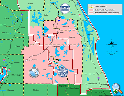
Well, there is one area of our state, not too far away, that is running out of water. Today, these counties are part of what is called the “Central Florida Water Initiative,” CFWI. They include: Seminole, Orange, Osceola, Lake, Polk, Brevard and Volusia.
I must divert for a moment because this is really something as this area holds the “headwaters of the Everglades.”
“Shingle Creek,” in Orlando’s Orange County, is generally considered to be the northernmost headwaters of the Everglades’ watershed. This is an area you probably drive right past upon a visit to Disney World. It was named after the cypress trees that were used to make roof shingles in the pioneer era and beyond.
In the 1960s and 70s, after the cypress trees were cut for the shingle industry, Shingle Creek and the other surrounding streams and lakes’ water-levels were “brought down” in order to allow more development. One of the ways this was achieved was through the Army Corp of Engineers’ canalization of the once long, serpentine, Kissimmee River. Canalization of the Kissimmee not only helped lower the lakes so they could drain, but also created lands along the now straight canal for ranch and real estate development.
Today, as we know, all that now dirty, unfiltered, water shoots down the Kissimmee into Lake Okeechobee and then is redirected to the St Lucie and Caloosahatchee so the sugar and vegetable farmers south of the lake have “dry feet,” as well… Thankfully, parts of the Kissimmee have been restored and society recognizes the canalization of the Kissimmee River as an environmental disaster. Our disaster.
Nonetheless, there is no way to completely undo what we have done, so now south of Lake Okeechobee and north of Lake Okeechobee often does not have enough water, while the Northern Estuaries sometimes HAVE TOO MUCH.
Where am I going with all this?
So fast forward, it is now 2014, and as I mentioned the “headwaters of the Everglades” and the counties surrounding it are literally “running ” out of water.
This is why the Central Florida Water Initiative, mentioned at the beginning of this write up, was formed.
An excellent article entitled “Central Florida Water Initiative, “A Regional Response to Avoid a Pending Crisis” written by attorneys Michael Minton, Laura Minton, and John Wharton, of Dean Mead for the Florida Engineering Society succinctly explains the history, goals, and future for the CFWI. I would like to share some of this article.
The article notes how from 2007-20012, the St Johns, South Florida, and Southwest Florida water management districts undertook an assessment of available groundwater for the seven counties listed at the beginning of this blog, noting insufficient quantities for the area’s projected growth— projected to be 6.6 million by approximately 2050. This would include an addition of 3,000,000 people to the population today.
Thus over time and through much coordination and work the CFWI was born.
After deep explanations, the article explains that the CFWI’s conclusions and recommendation include the following concepts: water is undervalued; continued use of just groundwater sources would cause unacceptable environmental impacts to the Floridan aquifer; the importance of conservation; the importance of alternative water sources, its expense and the coordinated regional effort that would be required to achieve such for the future.
The CFWI is obviously a complex effort thus I will not attempt to go into too great of detail. If you are interested, you can read more about it here:
(http://cfwiwater.com); (http://floridaswater.com/watersupply/CFWIinitiative.html ); (http://cfwiwater.com/pdfs/CFWI_RWSP_FinalDraft_Vol1.pdf)
What I must mention is that on the final page of the Dean Mead article something very interesting is stated:
“The Solutions Planning Team’s (STP) report is scheduled to be made public in Fall 2014. Once the findings of the SPT are approved by the Steering Committee, it is anticipated that the findings will be made available to the Central Florida Legislative Delegation. The collection of uniquely talented individuals who have volunteered their time and effort to serve on the committee has yielded many novel and creative concepts. Some of the creative opportunities look beyond the CFWI’s geographic boundaries and contemplate transmission of surface water from regions with excess water supply, to the detriment of their environment, to Central Florida to supplement the existing supply. These creative and innovative options are the type of out of the box thinking that long-term solution Florida’s water strategy and policy will require…”
I wonder and I hope they are talking about “us…”
____________________________
The Article, Central Florida Water Initiative, A Regional Response to Avoid a Pending Crisis by Dean Mead, was published in the JOURNAL of the Florida Engineering Society, to access this article you must be a member: (http://www.fleng.org/pubs.cfm)
