Tag Archives: 2022

True Beauty, SLR/IRL

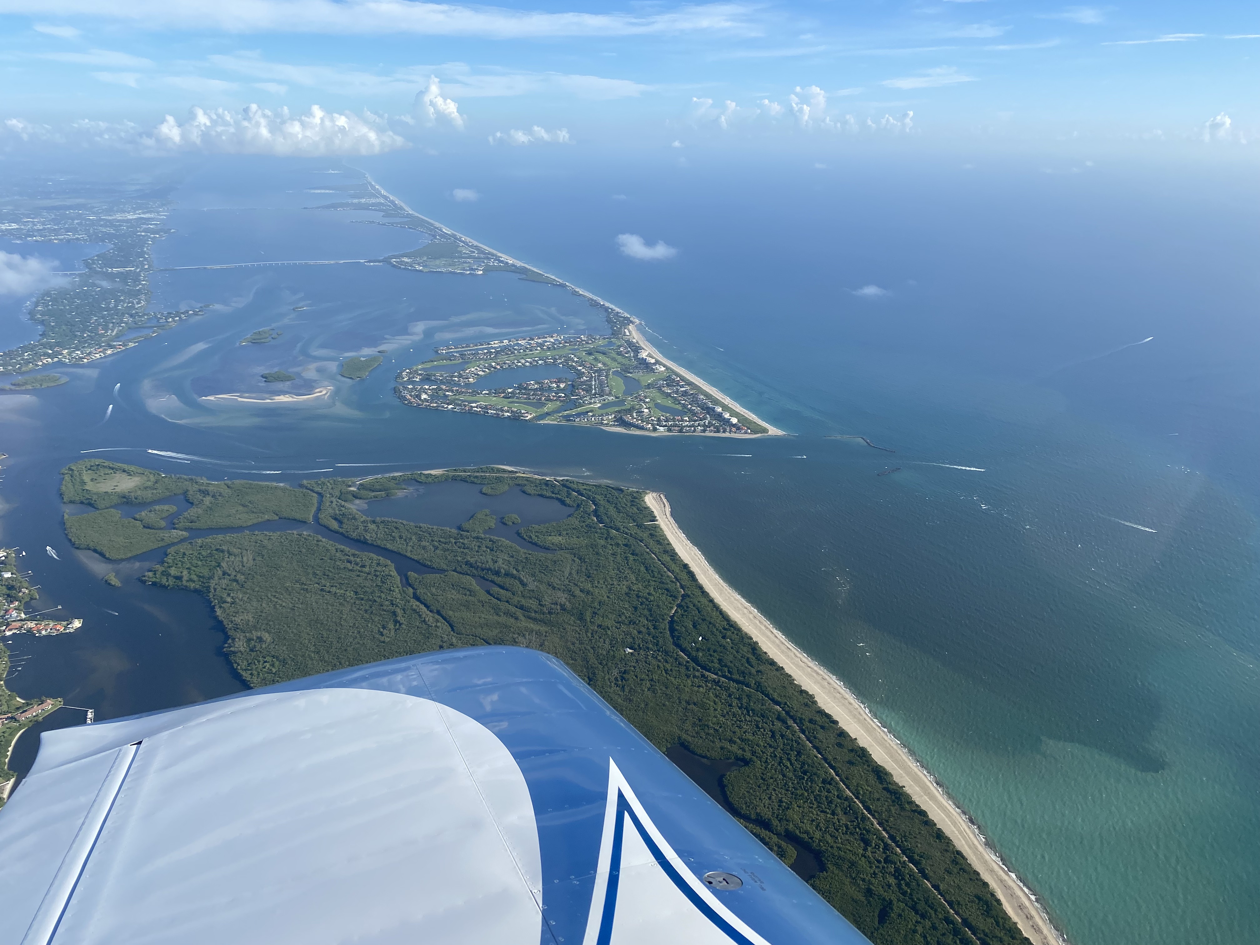
-L to R: The peninsula of Sewall’s Point lies between the SLR/IRL. The Sailfish Flats and Sandbar seagrass meadows lie between Sewall’s Point and Hutchinson Island. Witham Field, Stuart, can be seen west. The Atlantic Ocean is east. St Lucie Inlet State Park is located south on Jupiter Island. The St Lucie Inlet is cut between Hutchinson and Jupiter Islands. Today’s photos highlight the area’s returning seagrass meadows after their disappearance primarily because of years of damaging cyanobacteria laden Lake Okeechobee discharges, especially in 2013, 2016, & 2018. Photo Ed Lippisch, 8/26/22.When Ed came home from flying the RV on Friday, August 26, 2022, he said, “I think the aerials look good, you can really see the seagrasses.” I looked at him kind of funny. He never says anything like that. Looking on my phone, I could tell the photos were revealing, but it wasn’t until I viewed them full screen on my computer that I saw their true beauty. Ed’s photos reveal clear water, clear air, defined nearshore reefs, and lush seagrass/micro-algae meadows.

It is exciting to see and am I so glad Ed captured it! In the coming days and weeks tropical weather may be pushing our way. “Thank you Ed, for capturing the river before the height of hurricane season, before possibly more rains and more runoff.”

These just might be the most beautiful recent photos ever taken of the St Lucie River/Indian River Lagoon. Over the past couple of years, we’ve had some good ones of blue water alone, but blue waters cradling seagrass beds, the life of the sea itself, this is “true beauty.”

These improvements have only been possible due to recent  ACOE policy decisions – no major Lake O discharges for over three and one half years, and Mother Nature, who so far, has not brought any of her discontent our way.

At this time, it is in order to thank former City of Stuart Mayor, Merritt Matheson, who went to great lengths over the past four years to hold accountable and build relationships with the Army Corps of Engineers. Mayor Matheson led numerous boat tours and meetings inviting, colonels, commanders, and staff. His St Lucie River tours led by an elected,  passionate, educated, local helped the ACOE understand the fragility of our region and the intense ecological and health impacts caused by discharges from Lake Okeechobee. Mayor Matheson your efforts made a tremendous difference for the health of the St Lucie River. Thank you.

Canal system SLR/IRL, SFWMD


Awash

This post is for aerial documentation. With recent needed rains this past week in the St Lucie Region, the St Lucie River is “awash” from area canals and “local” runoff. But #NoLake O!

Remember: Don’t fertilize through rainy season-June 1-Nov. 30-and let’s all be aware that everything we or our four legged friends put on our lawns ends up in the river. Seagrasses are recovering let’s help not hurt.

Ed Lippisch & Scott Kuhns, August 19, 2:18pm, RV, Lake Okeechobee (no visible algae) to St Lucie River 

-Island in Lake O south of Buckhead Ridge also visible is Kissimmee River, now C-38  -St Lucie River at St Lucie Inlet 

Ed Lippisch, August 21, 8:45am Lake Okeechobee to St Lucie River, RV -Visible plume 

Canal systems dumping fresh water into SLR, SFWMD.

8-14-22 (South Sewall’s Point)

8-17-22

Visual Update SLR/IRL June 23, 2022

I am very fortunate to have a team of people, “River Warriors” who help me document from sky to water the St Lucie River/Indian River Lagoon. Today, I share photos taken by friend  Mary Radabaugh who overnighted in the area over Father’s Day weekend, June 18-19, 2022. She took amazing photos of nature: live sand dollars, growing seagrasses, wading birds, manatees, and sea turtles. Life is returning to the area.

Next, Dr Scott Kuhns shares five aerials he took the same weekend, on June 18,  around 11:30am. These photographs reveal clear waters with rain runoff plume over St Lucie Inlet and nearshore reefs. There is also a photo of the C-44 Reservoir filled to just over ten feet. This reservoir sits on the C-44 Canal and was just completed this past year as the first major CERP project. It is scheduled to be operational by 2023, although the ACOE is trying for earlier.

My husband, Dr Ed Lippisch, took his plane up yesterday. He shares four photos from June 22, 2022 around 12:30 pm that encompass the estuary from a higher altitude. The darker rain runoff is more visible. The estuary still looks good in the region near the St Lucie Inlet. Higher up the north and south forks the water is darker. There have not been major discharges from Lake Okeechobee in over three years. This is a very good thing and we must continue to make this our goal.

Thank you for all who fight for a clean and healthy St Lucie River!Periodic_Scientists_Call_2022-06-21

ST LUCIE RIVER/INDIAN RIVER LAGOON

I.-Mary Radabaugh, living sand dollar and more life, Sandbar near St Lucie Inlet between Sewall’s Point & Hutchinson Island, 6-18/19-22


I am adding two more wildlife videos 4:35pm, 6-23-22

A. Spotted Eagle Rays at the Sandbar, June 19, 2022,  by my sister Jenny and her husband Mike Flaugh.

B. Trigger Fish, Powers family dock, S. Sewall’s Point, IRL side June 23, 2022.


II.-Scott Kuhns, SuperCub, June 18, 2022 near St Lucie Inlet and C-44 Reservoir, 6-18-22.


III.-Ed Lippisch, Van RV, St Lucie Inlet SLR/IRL  June 22, 2022. 6-22-22.

SFWMD canal and basin map.


Aerials Sailfish Flats- St Lucie River/Indian River Lagoon May 2022

Ed is on a roll!

Yesterday, 5-23-22, at around 3:30pm, these aerials were taken of the Sailfish Flats, the confluence of the St Lucie River/Indian River Lagoon between Sewall’s Point and Hutchinson Island.

The water looks great and I have had reports of seagrass-although sparse-growing in some parts of this region. KEEP THE LOCKS CLOSED and thank you Ed for documenting the St Lucie!

Mind you, the entire river is not this color. The water gets more tannin and darker as you approach the locks and upper reaches of the forks. These were once fresh and clear. In a hundred years, things have drastically changed…

As you can see, the proximity to the St Lucie Inlet allows for flushing/cleaning of this area. Since repeated blue-green algae laden discharges starting in 2013, and then again in 2016 and 2018, the grasses have become sparse mostly due to poor light penetration. The inlet cannot flush when high discharges from Lake Okeechobee and area canals are pouring through for long periods of time.

Some of the shading you see is macro-algae not seagrasses. It takes years for seagrass to recover. With three good recent years they seem to be recovering. Things are looking up so long as Mother Nature and politics don’t get in way. Please continue to advocate for our waters!

I am including all photos- although similar- so you may compare and get the feeling of

~Flight~

1977 aerial below by Chris Perry for historic comparison.

Aerial of seagrasses in 1977 in and around Sailfish and Sewall’s Point.


Lake O’s Edge to Pal Mar/St Lucie Inlet

Greetings. Ed and I have just returned from three weeks of touring Florida’s west coast in our trawler, Adrift. It was awesome!  I am nowhere close to being back in gear (I am recovering one could say) but my husband Ed is…

Yesterday, 5-22-22, around 1pm, Ed took the RV for a spin and got some great aerials. I wanted to make sure to share. I will be writing more soon. Hope all my readers are doing well and enjoying the water!

~Flight~

-C-44 Canal at S-80, St Lucie Locks and Dam. No algae at S-80 but we did see some bubbling up in our wake in Lake O.

-Sugarcane burning near Lake Okeechobee…

Pal Mar’s lands  are under siege as you may have read about

-Light plume from rains, St Lucie Inlet at Hutchinson Island, Sailfish Point. Water is looking great after three years of no major discharges from Lake Okeechobee.-Sailfish Flats as viewed over Hutchinson Island. Pretty with seagrass “budding back.” Let’s keep those discharges at bay so it can grow, grow, grow!


Pre-Easter Flight SLR-LO

Ed took a pre-Easter flight in his new RV plane on April, 16, 2022 at 10am. He flew from Witham Field in Stuart west to Lake Okeechobee, back over parts of the C-44 Canal, and then over the St Lucie Inlet.

We are at the hight of the dry season. Once the wet season begins in the next couple of months, conditions will drastically change. We can use these photos as an “end of dry season base line.”

The St Lucie River/Indian River Lagoon looks very good as we have had little rain and no major Lake O discharges in three years. See page 14 below of “SFWMD Environmental Report,” – meeting date 4-14-22.As far as Lake O, although on April 8, 2022, the Martin County Health Department issued a cyanobacteria (blue-green algae) warning for area near Port Mayaca and  Lake Okeechobee, blue-green algae was not visible from the sky.  Please read press release.

We must stay vigilant.

I.

-Lake Okeechobee at S-308, Port Mayaca

II.

-C44 Reservoir/STA at Indiantown-at 10 feet being filled and check for safety by ACOE

-C44 STA and intake canal from C-44 canal

-More of Reservoir and STA -Caulkins Water Farm next to C-44 R/STA

III.

-C-44’s S-80, St Lucie Lock and Dam

IV.

-St Lucie Inlet with nearshore reefs visible, Atlantic Ocean  -Smile Ed!!!!!

First Mate of Clear Waters and Sparse Seagrasses

This past weekend, March 19, 2022, Ed and I had a chance to spend the night in the area of Boy Scout Island, “Adrfit.” We met up with our friends, the Radabaughs, of  “Cinnamon Girl,” and ate lasagna and drank wine under a full moon -toasting the Indian River Lagoon’s beauty and importance. It was magical! We brought along our Belgium Shepard, Luna and our cat, Okee. The entire family was present. These are the days to be thankful for. But something was missing…

On Saturday, we tooled around on our blow-up canoe. Ed accidentally hit me over the head with a paddle and I still have the bump to prove it! I screamed out loud! We just about capsized in the strong winds, raging current, and choppy waves, but we held fast.

It was an incredibly stunning night and day. But there was one thing missing in the clear waters, our seagrass meadows. It may lush-out as we approach summer, but it certainly seems lean. Nonetheless, we saw manatees, giant leopard rays, starfish, schools of mullet, pelicans, and many kinds of wading birds. I just pray that the seagrass returns, because without, clear water or not, we are a desert or becoming one.

There have been no major discharges from Lake Okeechobee in three years, this is certainly giving the southern lagoon a fair chance for recovery. But again, clear water must have seagrasses to be of ecological value.

SFWMD March 10, 2022, Ecological Report

Rivers Coaltion  meeting March 24, 2022

MRC IRL REPORT 2022 CARD UPDATE

-Sunrise over St Lucie River/Indian River Lagoon-Moonset over Sewall’s Point-Cinnamon Girl-Cloud formations-Morning visitors! -Okee watches  Dutch and Holly -Ed and Luna go for a spin-A journey through the mangrove forests -Mullet

-Red mangoes and black mangroves roots. Black mangroves can get very large and have straw-like roots; red mangroves are known as the “walking tree” as they stride-out in arches -Ibis fly-A cathedral of red mangroves!

-Don’t fall in!-Mary, Lisa, Dutch and Colton taking a look at the water and s”seagrasses”-View of Boy Scout Island -so blue!-Area around Boy Scout Island where once seagrass was plentiful. Now small blades,  rhizomes, and macroalgae.

-Looking west, brown pelicans float after diving for fish. At least they can see. No coffee colored Lake O or canal water today! This area near the St Lucie Inlet gets lots of flushing, most of the St Luice does not. -Colton found a nine-armed starfish, eastern area -Luna watches, her black coat juxtaposed to turquoise water. Luna does not run in the shallow waters. She would damage the roots remaining seagrass. She is happy anyway!

THIS 1977 AERIAL BY CHRIS PERRY SHOWS HOW LUSH THE SEAGRASS IN THIS AREA OF THE ST LUCIE INLET ONCE WAS. TODAY THIS AREA IS BARREN. I was 13 years old at the  time this photo was taken; I am 58 today…

LOSOM Presentations – Project Delivery Team Meeting – Jan. 12, 2022

This blog post is for documentation purposes so that members of the public who may not be on the LOSOM list have access. The presentations are scientific. This web-ex meeting occurred 1-12-22.

“The focus of the Jan. 12 PDT engagement will be (was) an overview of the final model data  and an update on the operational guidance development.” said LOSOM Project Manager Tim Gysan.“The agenda will include an overview of the modeling results of the LOSOM Preferred Alternative and an update on the operational guidance development. The guidance provides the instructions to the water managers and operators and defines the ability of LOSOM to address the varied climate conditions we may experience over the next decade. We value your continued participation in this development as we work towards the Draft EIS and water control plan,” said Gysan.

The Project Delivery Team (PDT) members include only the federal officials and elected officers of state, local or tribal governments or their designated employees with authority to act on their behalf acting in their official capacities…”  

ACOE press release 

~See links for power point presentation slides

FINAL LOSOM PDT 1.12.2022

LOSOM South Florida Metrics Overview 12 January 2022

Leading Up to LOSOM

LOSOM is a component of the Central & Southern Florida System Operating Plan and stands for LAKE OKEECHOBEE SYSTEM OPERATION MANUAL. This manual will update Lake Okeechobee operations including discharge amounts and timing to the estuaries. 

When Ed told me he was going to take the Maverick out this morning, I decided it was a good time for me to document the Lake Okeechobee System Operating Manual. This very technical process has been well reported but remains difficult to understand. Today, I will share a few slides from a recent South Florida Water Management District Meeting on the subject for those who may wish to catch up and for purposes of documentation.

Tomorrow, July 19, 2021, at 1:30 pm the Army Corp of Engineers will announce what they call their “preferred plan” for a new lake schedule referred to as LOSOM. This is very exciting yet stressful, and numerous people have been working on this for years. Even with the announcement, the new lake schedule will not be implemented until 2023 as this slide from SFWMD’s Jennifer Reynold’s displays.

Although many are talking about “enhanced” plans, the Army Corp will be choosing one published plan to begin their “balancing process.” You can view an overview of the plans below. Different stakeholders like different plans depending on their positions. The St Lucie stakeholders have rallied around Plan CC “with enhancements.” At the most recent SFWMD governing board meeting another plan based on CC, entitled S.R. 3.5 was used as an example of how to “optimize” the CC plan. You can watch the meeting here to see the presentations and discussions.

Presentation SFMWD, Jennifer Reynolds, 7-15-21.

Suplemental Material SFMWD

SFMWD meeting 7-15-21 video/all documents. 

In the end, there was discussion about the 3.5 model (positive and negative) but board members supported the policy considerations and “direction” the SFWMD was headed. Please watch the meeting video above for specific comments. (Only 8 hours!)  For tomorrow, the main thing is to keep one’s eyes on the above charts, as those are the charts the Army Corp will be referring to to chose a “preferred plan” as the process for “balance”‘ continues. The Army Corps next step after choosing a preferred plan is to travel around for a “listening tour.” So be sure to look for announcements of their visit to your area.

Back to the slides!

Here are the SFWMD governing board policy considerations building upon Alternative CC. Note algae blooms are now a consideration.

Both Governor DeSantis and the SFWMD put forth statements earlier in the year for the goals of LOSOM. All were big shift in favor of the environment.

As this contentious process continues, we must recognize how much progress has been made for the estuaries. Never before have the estuaries had such a central seat at the table. This will certainly translate into improvements!

Thank you to the Army Corp of Engineers for this remarkable LOSOM NEPA environmental process. I look forward to your decision tomorrow and the continuation of an optimized plan that we  can all be proud of.

Vice Mayor, City of Stuart, Merritt Matheson speaks for the SLR.
Congressman Brian Mast stayed the entire meeting speaking for the SLR.