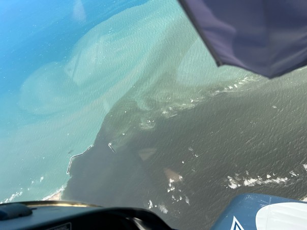
 I wanted to provide a visual update of the St Lucie River/Indian River Lagoon. Even though the river looks dark and silty, as 2022 comes to a close, we remain fortunate that there have been no major discharges from Lake Okeechobee to the St Lucie River since 2018 and no discharges to the St Lucie this year even though Lake Okeechobee got very high -maxing out at 16.51 feet.
Recently, there has been quite a bit of rain in Martin County. This follows the rains of Hurricane Ian and Hurricane Nicole. Thus the river looks dark and silty from weeks of runoff. The runoff now is coming from surrounding lands as well as C-23, C-24 and C-25 out in the IRL at Ft Pierce. There are also hundreds of old ditches that dump into the St Lucie River running though creeks such as Dansforth, Willoughby, Warner and others.
Thankfully the Indian River Lagoon South project is underway by the ACOE and local sponsor SFWMD to offset the destruction of the major canals of the Central and Southern Florida Plan. If things go well and the economy and political will remain in place, the remainder of these projects should be complete in ten or fifteen years. The C-44 Reservoir and STA in Indiantown, Martin County is complete. Ten to fifteen years sounds like a long time, however, these are gigantic, expensive projects working to undo gigantic problems as our population skyrockets.
In the meanwhile we should be working on going septic to sewer where necessary and improving our yards by using little grass, fertilizer, or pesticides; planting more native and Florida Friendly plants; using less water, picking up dog waste; and realizing everything we put on our laws or fertilize -crops and/or yard plants- ends up in the water ways! We have to be part of the solution. Don’t expect the government to do it all.
AERIAL PHOTOS ST LUCE RIVER UPDATE
Ed Lippisch, my husband, and Scott Kuhns, our dear friend, took the aerials I am sharing today. The river does not look great due to so much rain. Thank goodness there are no Lake O discharges on top of this “local runoff.” Of which it really is not! This runoff has been mainlined here through canals of the Central and Southern Florida Plan.

Next year they both Ed and Scott will have been River Warriors for ten years documenting the St Lucie! As eyes in the sky they provide a wider view and inspire a wider net of recovery for these waters. My brother, Todd’s web site eyeonlakeo allows for full time satellite and data updates.
SCOTT KUHNS, SUPER CUB, December 16, 2022 around 9:40 am. St Lucie Inlet (Hutchinson Island) plume about 12 miles south past Peck’s Lake, (Hobe Sound).


ED LIPPISCH, VAN’S RV December 18, 2022 around 12:15 pm. Plume at St Lucie Inlet, and dark runoff waters discoloring the entire estuary even close to the inlet around Sewall’s Point and Sailfish Point, Hutchinson Island. 


Most recent rain as shown in my rain gauge. Just under 4 inches around December 14.
12-21-22 Added Presentation from ACOE Periodic Scientist Call: Periodic_Scientists_Call_2022-12-20


This is Jacqui Thurlow-Lippisch. On-line, I removed two photos of the Loxahatchee River plume at Jupiter Inlet taken by Scott Kuhns. Sorry about that. When I looked closely and saw the condo near the inlet I knew I’d made a mistake! This post is just for St Lucie River/Inlet.
Thanks for Ed’s, Scott’s, Todd’s, many many other’s and your communications about educating and teaching about clean smart water. Thank you!! Merry Christmas, Happy Holidays and a great New Year. Solidarity y’all