Category Archives: aerial photos

River Warrior Times 5-16-21

Port Mayaca, Structure S-308 at Lake Okeechobee opens to Canal-44 into St Lucie River. S-308 is open for water supply for agriculture but is not going through S-80 into the St Lucie River/ Indian River Lagoon. Aerial, Ed Lippisch, 5-5-21.

River Warrior Times 5-16-21. This piece is written specially for Lake Okeechobee.

It was my intension to write a summary water piece every two weeks. I last wrote on April 25, 2021.Today, I will try to catch up.

If I had one phrase to describe what has happened since April 25, it would be “high-alert.” Governor DeSantis visited on May 10, giving direction as his executive order 19-12 is the guidepost for the Department of Environmental Protection and the SFWMD.

The blue-green algae bloom at Pahokee Marina, I wrote about last time, was cleaned up through a cooperative of the South Florida Water Management District and the Department of Environmental Protection. This is a first as globs of purple, blue, green, and grey cyanobacteria -blue green algae- sat in marinas and inside canal communities in 2016, and 2018 until they rotted and fell to the bottom. This time, under Governor DeSantis of which DEP and the SFMWD sit organizationally, it was determined (under Section 1 part I of 19-12) to remove the toxic algae via vacuum and chemical treatment, relocating what Palm Beach County could not take safely, far away to District lands away from people and wildlife.

Keith W. Babb, Mayor of Payhokee, attend the May 13 SFWMD Governing Board meeting and was very grateful. You can listen to his comments at 39.00 the beginning of the meeting. Congressman Brian Mast, who led Governor DeSantis’ transition committee, also provided fiery commentary.

Although it is definitely a positive that the toxic algae was removed, we must ask ourselves a question. How are we going to pay for this again, and again, and again? A precedent has been set. Is vacuuming each time sustainable? With Lake Okeechobee in its present condition this is a very relevant question.

As Mark Perry, the Executive Director of Florida Oceanographic has repeatedly stated: “Unless we address the source of the problem in the upper watershed of Lake Okeechobee, we will never reach the 105 metric tons at 40 ppb.” Translated, that means the pollution numbers coming into the lake are high, in some basins over 600 parts per billion phosphorus. You can’t vacuum away as an avalanche of pollution pours in!

The situation is complex. However, the handling of Pahokee Marina is symbolic of a larger problem. I would have liked not only DEP and SFWMD to be in the spotlight at the Pahokee Marina, but also FDASCs the Florida Department of Agriculture and Consumer Services. Why? Because the lake did not get sick overnight, and the history of Lake Okeechobee is an agricultural one. This is reflected in “who” is in charge of water quality.

First, back-pumping fertilized and chemical-leaden water into Lake Okeechobee was common practice and allowed by the by the state. The sugar industry/EAA imparticularly partook of this practice for decades. It almost killed the lake. In the 1970s and 1980s lawsuits forced water that was once back-pumped into Lake Okeechobee to flow south, sparing the lake, but creating a new issue of destroying the Everglades. This in turn spurred other lawsuits so that today Everglades Agriculture Area (EAA) runoff must first be filtered through Storm Water Treatment Areas, south of Lake Okeechobee before it can enter the Everglades Protection Areas or Everglades National Park. Most of this was paid for by taxpayers, just like the clean up at Pahokee Marina.

Lake O, EAA, STAs, and WCAs. (Map SFWMD)

Lake Okeechobee, though in a better position than in 1970 continues to be fed high concentrations of phosphorus and nitrogen mostly from agriculture areas north of Lake Okeechobee. Thus destruction already done from the early years is locked up in sediments,  and the new destruction that continues makes for a hyper-eutropic lake that now blooms every year.

Not a good situation. So how is fixing our waters supposed to work? Who is in charge of water quality?

The Northern Everglades and Estuaries Protection Program (373,4595. Florida Statutes) directs the Florida Department of Environmental Protection, the Florida Department of Agriculture and Consumer Services, and the South Florid aWater Management District to work together to reduce pollutants and achieve water quality standards in the the Lake Okeechobee, St Lucie River, and Caloosahatchee River watershed through Basin Management Action Plans and Total Maximum Daily Loads program (403.067. Florida Statutes.)”

No one agency is in charge of water quality. Like it or not, in Florida, three agencies have this responsibility. As Florida Statue requires, we must all work together to turn Florida’s organizational chart from a line into a triangle. Until FDEP, SFWMD & FACS are truly working together, there will not be improvement to Lake Okeechobee’s water quality and Florida’s tax payers will be on the hook.

THE TRIANGLE!

Organizational chart State of Florida. Note the members of The Triangle (circled) responsible of water quality. The Dept. of Ag is a cabinet position. DEP and SFWMD are lower agencies but fall under the top tier, the governor. The governor is doing a great job but he can not do it alone!

Links to timely information:

JAX ACOE keeps S-80 closed, adjust flows to Caloosahatchee

SFWMD operations statement Ops_Position_Statement_May_11_17_2021

EyeonLakeO website Todd Thurlow

DEP algae bloom dashboard 

FOS SLR water quality report

Orca report on dead manatees in the IRL by county


21 Days After the Discharges~2021

-St Lucie River/Indian River Lagoon March 27, 2021. Photos Dr Scott Kuhns.As we all know, the ACOE began discharging 500 cubic feet per second of Lake Okeechobee water to the St Lucie River on March 6, 2021. At this time the lake was at 15.23 feet. There were/are great concern as wet season is rapidly approaching…

Since March 6th, Ed and I have been documenting the discharges for 2021 so that visually we have a record of changes as time goes on. We have been doing this since 2013’s Lost Summer that spurred a River Movement that turned over the tables, has evolved in many directions, and continues to work on changing Florida water policy today.

In today’s blog post it not Ed and I, but friend Dr Scott Kuhns who is documenting the discharges. Unlike me addicted to my iPhone, Scott uses a professional level camera. Wow!

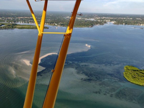
Presently, Ed’s plane is in the shop so I am very grateful to pilot Steve Schimming and pilot/photographer Kuhns, for filling in and taking these excellent aerials yesterday, March 27, 2021 around 10:30 am. It was a full incoming tide with full moon rising today, March 28th. The water looks beautiful. The photos even reveal the near shore reefs!

Such conditions can push back against 500cfs coming from S-80 as presently there are no discharges from canals C-23 and C-24 because it is bone dry right now. Lake Okeechobee is evaporating and is now at 14.56 feet. This remains high. Please view the information I have included at the end of this blog for details of conditions from Florida Oceanographic as well as SFWMD & ACOE content. No discharges are good discharges but it is wonderful to see these blue aerial photographs as Spring is sprung and wildlife is procreating! Hopefully oysters, fish, and bird life will have a good season and mature before summer storms are arrive.

In closing, thank you Scott and Steve for a classic view from the Cub also known as the “River Warrior II;” so good to see her! She was and remains the “original!

~Documentation St Lucie River/Indian River Lagoon, March 27, 2021. Scott Kuhns & Steve Schimming reporting from the Piper Super Cub.

-Over nearshore reefs off Peck’s Lake, all photos by Dr Scott Kuhns.-Wide views St Lucie Inlet State Park and St Lucie River/Indian River Lagoon. -Sailfish Point and St Lucie Inlet note near shore reef! Beautiful! Also damaged by discharges as documented by Harbor Branch. -Great shot of nearshore reefs off the St Lucie Inlet.-Looking towards Stuart and the Crossroads over St Lucie Inlet. -Part of Sandbar area. Could that be seagrass coming up?-Opening to Jupiter Narrows. Note dredge. -Sailfish Flats still devoid of seagrass.-Sewall’s Point between St Lucie River on west and Indian River Lagoon on east-Over south Sewall’s Point looking towards Stuart -Hell’s Gate, bottleneck between Stuart and Sewall’s Point, St Lucie River.-Witham Field, Stuart and looking west.-Below: Over Langford Landing that still looks like an atom bomb hit after five years of development-after they tore down all of Francis Langford’s beautiful trees and flattened the historic bluff that pirates used to use for an outlook. I hope they plant some vegetation soon! Aggg!-Roosevelt Bride over St Lucie River.-Looking west towards the Roosevelt Bridge, Palm City and Rio in foreground. South Fork and Beginning of North Fork visible-Another view of Langford Landing with no trees  after five years, the former home of the famous and generous Frances Langford.-Langford Landing marina is filling up and is located at the merging point of north Sewall’s Point and Rio. This would look a lot better with some stately trees.-Here we see the Harborage Marina near the Roosevelt Bridge in Stuart/Rio. River water is not blue here as flushing is poor compared to St Lucie Inlet. The St Lucie has been ravaged by discharges from C-44, Lake O, C-23 and C-24 beginning in the 1920s.-Looking west over the Roosevelt Bridge note C-23 Canal in distance that separates Martin and St Luice County. Over-drainage is the root of Florida’s water problems today. As a farmer once told me, “We spent 100 years taking the water off the land, and we’ll spend 100 years putting it back on…”


Previous Posts Jacqui & Ed:

Day Before the Discharges, March 5, 2021

7 Days After the Discharges

15 Days After the Discharges: https://jacquithurlowlippisch.com/2021/03/22/15-days-after-the-discharges-2021/

Helpful Recent Information:

Florida Oceanographic water quality report grades a “B” for March 24, 2021 click here.

ACOE March 26, 2021 press release about reduction in Caloosahatchee Lake O releases, St Luice to remain the same click here.

ACOE, Lake O on 3-28-21, at 14.56 feet: https://w3.saj.usace.army.mil/h2o/reports.htm

SFWMD staff’s recommendation to the Corps regarding Lake Okeechobee operations for the period March 23 to March 29, 2021: Ops_Position_Statement__Mar_23_29_2021


15 Days After the Discharges~2021

Ed and I continue to  document the discharges by air – “a picture speaks 1000 words…” ACOE continues discharging from Lake Okeechobee at 500 cubic feet per second as reported last week and week before.  Lake Okeechobee is going down, and today, 3-22-21, sits at 14.79 feet.

Previous Posts:  

Day Before the Discharges, March 5, 2021

7 Days After the Discharges

Information: 

~Most recent ACOE Periodic Scientist Call, 3-10-16: Periodic_Scientists_Call_2021-03-09

~SFWMD 3-16-21: Ops_Position_Statement__Mar_16_22_2021

~Florida Oceanographic Society  WQ Report, 3-11-21/3-17-21

Aerials taken over St Lucie River/Southern Indian River Lagoon on 3-21-21, 12.30 pm, incoming tide,  over St Lucie Inlet and Sailfish Flats between Sewall’s Point and Hutchinson Island, Martin County, Florida. One can see the effects with sediment cloud discharging into Atlantic Ocean and darkening waters. Nonetheless, salinity conditions are safe for oysters and Florida Oceanographic has water quality at a B-. Please read information section above for details.

See you next week. 

J&E 

Aerials 3-21-21 E&J Lippisch


7 Days After ~Discharges March 2021

~Ed takes a picture at 3000 feet

I. HELPFUL INFORMATION:

1. ACOE Statement regarding discharging March 5, 2020

2. Lake Okeechobee level 15.06 feet

3. ACOE Pulse Release Schedule: 4.SFWMD staff’s recommendation to the Corps regarding Lake Okeechobee operations       for the period March 2 to March 8, and March 9 to March 15, 2021: Ops_Position_Statement__Mar_02_08_2021 

Ops_Position_Statement__Mar_09_15_2021 

5. Florida Oceanographic’s Weekly Water Quality Report 

6. HAB update and science data: Todd Thurlow’s website eyeonelakeo

II. DOCUMENTING THE DISCHARGES -all photos taken 3-13-21 by J&E on outgoing tide around 1pm. Friday, March 5, my husband Ed and I , took aerials of the St Lucie River/Indian River Lagoon just one day before the Army Corps of Engineers began discharging to the St Lucie River on March 6, 2021. I can’t say that in all our years of taking photographs since 2013, we have done so just one day before discharges began. Thus, now Ed and my goal is to take photos every week as long as the discharges continue. This will give us a really good opportunity for visual comparison.

We all know a picture speaks a thousand words…

Today, Saturday, March 13, 2021, is exactly one week after discharges began-(this time). You can see last week’s photos here! Do you think they were prettier than todays? I must admit, today, the water coloring looked better than I anticipated and that’s good news. This may not be the case in the coming weeks especially if the ACOE ups the discharge level.

We shall see.

~Jacqui and Ed

-St Lucie Inlet and Sailfish Flats at Sailfish Point-Sailfish Flats with no visible seagrass-St Lucie Inlet -A faint plume is visible going south along Jupiter Island-St Lucie River and Indian River Lagoon-Looking south over Hutchinson Island at St Lucie Inlet-Views north along Indian River Lagoon -At St Lucie Inlet looking over Jupiter Narrows to Port Salerno and Stuart-Water just outside St Lucie Inlet on north side, reefs visible as is sediment exiting inlet -Another view encompassing almost all: St Lucie River, Southern Indian River Lagoon -Looking south towards Palm City where the South Fork connects to the C-44 and Lake Okeechobee when structure S-80 and S-308 are open. -Looking east toward the cross shape and forks of the St Lucie River. IRL in foreground. Sewall’s Point lies between the St Lucie and IRL.

Day Before the Discharges, March 5, 2021

Yesterday, Friday, March 5, 2021, around 3:30pm, my husband Ed and I, took a flight over St Luice River/Indian River Lagoon. We knew we needed to document because word on the street had been that there was a good chance, with Lake Okeechobee over 15.00 feet, and rainy season approaching, the SFWMD and ACOE would soon be recommending a special HAB DEVIATION-discharging to the estuaries. Since 1948, the two agencies have worked together to manage the Central and South Florida System

In any case, when Ed and I heard the announcement 4:48pm, less than an hour after arriving home from our flight, -that the ACOE would open S-80 at St Lucie Locks and Dam from Lake Okeechobee- “tomorrow, March 6th,” we were speechless. 

“Wow. Thank God we got up in the plane,” I said to Ed. 

Today, I offer our St Luice/Indian River aerials as a visual day-before-discharges baseline.  Of course I am terribly disappointed. Ed keeps telling me I need to cheer up. I doubt that  I will, but I can say that  I am grateful that now water will also start going south, and that natural resources are being taken into consideration by the agencies. Unfortunately, there are not so many natural resources left. 

~As we have since 2013, Ed and I will continue to document the discharges. 

Please read the ACOE March 5, 2021  announcement to begin Lake O discharges to the estuaries.

For the technical, please read the SFWMD Operation Position Statement March 4, 2021: Ops_Position_Statement__Mar_02_08_2021

SFWMD image: C&SFFCP’s canals to the St Lucie. The western C-44 and Lake Okeechobee had no historic connection the the St Lucie River. The first five photos were taken in the area of the St Lucie Inlet over Sailfish Flats between Sewall’s and Sailfish Points. The flats presently are devoid of seagrasses. -Looking east over the St Lucie/Indian River estuary from Stuart to the Atlantic Ocean.-Looking south to Jupiter Narrows of the Indian River Lagoon. The St Lucie enters around the peninsula of Sewall’s Point. -St Lucie Inlet and “Crossroads/” Where the St Lucie and Indian River meet and exit the St Lucie Inlet.  -Close up of St Lucie Inlet and Crossroads.-Looking north, up the Indian River Lagoon.  -Jupiter Narrows looking south over Peck’s Lake. Note a controlled burn in Hobe Sound in the distance. -North fork of the Loxahatchee River lies in Hobe Sound and Jupiter just south of the St Lucie River. -Circling back over the St Lucie Inlet near St Lucie Inlet State Park on Jupiter Island. Here you can clearly see the waters that lie between Sewall’s Point and Sailfish Point at the Crossroads of the SLR/IRL. -Looking west over Sewall’s Point and Witham Field towards Stuart one sees the north and south fork of the St Lucie River and the Indian River Lagoon on the west side of the peninsula. Look hard and you will see the straight line of the C-23 canal-the boarder of Martin and St Lucie Counties.

SLR/IRL up to 7000 feet

~Documenting the St Lucie/Indian River Lagoon. Sewall’s Point, Ed and my home, lies between the St Lucie & Indian River Lagoon. My husband, Ed Lippisch, flew high, up to 7000 feet, to take photos of the St Lucie River/Indian River Lagoon, and S-80 (St Lucie Locks and Dam), on Sunday, February 21. The pictures were taken around 2:45pm on a very windy day. (Thus I declined an invitation!) Ed basically made a big circle. 

I am including all 52 photos as each one presents a slightly different perspective. Ed flew from the Crossroads and inlet of the SLR/IRL west to S-80 along the C-44 canal. There he saw no discharges coming through the gates from either the C-44 basin or Lake Okeechobee. Most recently, the ACOE halted discharges on January 9th, 2021 after 3 months of discharging. The river is starting to recover in appearance, but not soul.

Today, Lake Okeechobee is at 15.42 feet.

Tomorrow at 3pm the ACOE will hold a media call to announce their operational decisions for the coming week/s. James Yochem, spokesman for the Corp, has shared the following media advisory. The public usually does not speak on these calls but can listen-in. 

MEDIA ADVISORY:

The U.S. Army Corps of Engineers Jacksonville District will conduct a briefing with interested media representatives regarding water management for Lake Okeechobee and south Florida. The media briefing will be held Feb. 25 at 3 p.m.

Please join the call using this information:

US Toll Free    844-800-2712
Access code     199 453 9583

If you are asked for an attendee ID number, dial #

It is very important that we are paying attention to “all things river”and “speaking up for the St Lucie” when possible as we approach wet and hurricane seasons. 

Thank you Ed for the recent aerials!

~To view Ed’s photo essay documentation prior to this one on February 3, 2021, see Milky Waters!

~To review what happened to the St Lucie in Toxic 2016, see Too Unthinkable.

About Jacqui Thurlow-Lippisch 

Milky Waters

~St Lucie Inlet with Crossroads of SLR/ILR at Sewall’s Point Ed’s February 3, 2021 photos of the St Lucie River & Indian River Lagoon at the St Lucie Inlet are unusual. Taken during cold temperatures and windy conditions at 2:15pm – at “dead high tide,” they show the incoming blue waters with a milky quality juxtaposed to the darker estuarine. This combination is one I have never seen, ever. Ed and I have been documenting  since 2013. When I first saw these photos, I posted a few on Facebook stating: “Interesting…”

Later, my brother Todd wrote back: 

“I just saw Ed’s pictures of the river.  When we were out last weekend the St. Lucie was that milky blue.  With the pounding waves offshore, the water was full of suspended sand.  You would think that sand is actually beneficial when it is transported inside the estuaries to settle on top of the muck bottom.  I did YouTube videos of the Bahamas after Dorian when the entire Bahama bank and outer reefs were that same milky blue.”

So that’s what’s going on! Interesting! 

Today I share more of Ed’s recent photos. They are taken from 4000+ feet which gives a much broader perspective and highlights the beauty of the St Lucie Inlet region in spite our struggle to revive our seagrasses and protect our water from discharges, especially those of Lake Okeechobee. On February 3, when these aerials were taken, the ACOE was not discharging having halted January 9th, 2021 after 3 months. At the present moment the ACOE does not have plans to discharge from Lake Okeechobee. The lake is presently sitting at 15.37 feet. 

This could be problematic for the St Lucie come summer…

*Thank you to my husband, Ed Lippisch for taking these photos! 


The Green Ridge

Although I first took this photo on January 21, 2021 to document the layer of smoke hovering at the horizon due to the burning sugarcane fields, I later noticed the clear aerial composition of the Green Ridge. Thus I share today…

Looking even briefly at the photograph, you will notice that this ridge is scraped flat by agriculture fields and 1-95 swinging over it – to take advantage of the high 30-35 foot topography.

So what is the Green Ridge and why is it important to the St Lucie River?

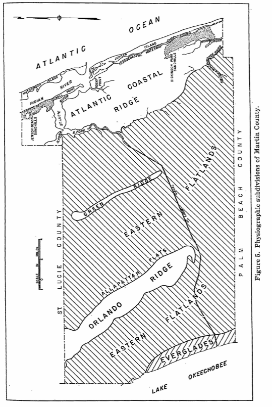
You may have recently read my post on Allapattah Flats where my brother utilized the map below from a 1960’s U.S.Geological Survey, “Martin County” report, on water resources prepared by William F. Lichtler? This report gives an excellent breakdown on pages 7-11; but even if you don’t read it, you can see it!

The Green Ridge guided waters south as they traveled slowly through the marshy Eastern Flatlands being deepest closest to the Orlando Ridge, Allapattah Flats. (For reference, today Indiantown lies in the southern portion of the Orlando Ridge.)

When the St Lucie Canal, (C-44) was cut ca. 1914-1923 and then deepened, widened, and “improved” many times since, it caused the waters moving southeast to shoot down into the St Lucie. Today, due to agriculture and development, these water are polluted and basically unfiltered and have been allowed to be so for many, many years.

And when Lake Okeechobee is opened into the St Lucie Canal…we all know what happens then. Complete destruction from a water source, Lake Okeechobee, that also was never connected to the St Lucie!

For years I tried to understand the Green Ridge, and it’s importance, now I think I do. In restoring our waters it is helpful to be able to envision how Nature functioned before humans altered the landscape to the point that she is almost unrecognizable. 

-Red baloon designates the Green Ridge


Finding the Shark River

When Ed and I recently visited Flamingo and rented a boat to explore White Water Bay, my goal had been to find the Shark River. I never found it…

I had wanted to see this river because although there are many Everglades’ rivers, the Shark is the most associated with Shark River Slough. Even though this slough, this river of grass, has been amputated by the Everglades Agricultural Area, Tamiami Trail, and eastern coastal development, getting waters into Shark River Slough and the Shark River still translates and is actually improving: “Sending Water South.”

So we took a flight…

Ponce de Leon Bay, where much of this water exits, is particularly breathtaking to see. The geometric shapes, shades of green, brown, and blue create a giant puzzle. It makes me want to put all the pieces back tother again.

It was so wonderful to finally find the Shark River!  I wanted you to see it too! The primary goal remains, to send more water south; this we must envision…

-Everglades Rivers flowing southwest out of Shark River Slough 1-21-21, photos JTL&EL -Ponce de Leon Bay where Shark River exits into Florida Bay The Shark River is the primary river you see coming into this area of Ponce de Leon Bay. White Water Bay  is to the right. It all kind of blends together. 

  1. Shark River, red dot follow northeast; 2. Shark River Slough, large most far right area above shark river -seemingly brownish green – running into Shark River 3. Water Water Bay appears as a dark green depression southeast of and connected to the Shark River; 4. Shark River exits at Ponce de Leon Bay into Florida Bay. Florida Bay is in dire need of more fresh water. 

Documenting the Discharges, December 2020

Documenting the Discharges, December 2020

Eyeonlakeo

I posted most of these photos on Facebook, but today I will give explanations and document on my blog. From above, our St Lucie/Indian River Lagoon remains beautiful, but we must be sensitive to the losses beneath the waters. These aerials were taken during  a “slack tide” between 12 and 2pm on December 9, 2020 by my husband, Ed Lippisch. December 9th was the last of five days the ACOE stopped discharging from Lake Okeechobee; however S-80 was discharging “local runoff.” (Click on chart above.) Unfortunately, due to high lake level and lack of storage reservoirs, since these aerials were taken, the ACOE has begun ramping up Lake discharges once again. 

Below Lawrence Glenn of the South Florid Water Management gives a comprehensive ecological report covering low-salinities and loss of oyster spat in the St Lucie and other aspects, positive and negative, for the entire Everglades system.

Below is an explanation of aerials documenting discharges December 9, 2020. All photos by Ed Lippisch.

-S-80 at St Lucie Locks and Dam discharging local basin S-80 runoff on December 9, 2020

S-308 at Port Mayaca, Lake Okeechobee closed on December 9, 2020. No algae visible. 

-Plume of along Jupiter Island south of St Lucie Inlet

-Dispersing plume in Atlantic Ocean just past Peck’s Lake in Jupiter Narrows

-St Lucie Inlet -St Lucie Inlet State Park, Sailfish Point, Sewall’s Point, Stuart, Jensen 

-Looking north to Sailfish Flats between Sewall’s Point and Hutchinson Island. This area has greatly degraded since 2013 as far as loss of seagrasses and fishing opportunities 

-The area below, especially around Sailfish Point, was once considered “the most biodiverse estuary in North America” as documented, first, by Grant Gilmore

-This photo reveals seagrass loss across many areas of the Sailfish Flats 

-Another view between Sewall’s and Sailfish Point, a seeming desert…

-Close up, Sailfish Point 

-Sewall’s Point, east Indian River Lagoon 

-Sewall’s Point is a peninsula surrounded by the St Lucie River on west side, and Indian River Lagoon on east side 

Ed Lippisch, selfie. Thank you Ed! 

As you can tell, I have lots of people helping me. Whether it is Ed flying or my brother Todd who provides an incredible easy to read website called EyeonLakeO. You can click below to check it out. The more we know, the more we document, the more we can overturn the destruction of our beloved estuary…

Eyeonlakeo website by my brother, Todd Thurlow. 

The Discharge/No Discharge Difference, St Lucie River/Indian River Lagoon

Looking back through my photo library, I was stuck by the color differences between these photos, so I decided to share….

The first two photos were taken recently, Saturday, December 5, 2020, the afternoon of the same morning the ACOE closed S-80 at the C-44 canal, and S-308 at Port Mayaca, Lake Okeechobee. This seems a bit quick for improvement, but so it was.

The second two photos were taken almost two months earlier, October 17, 2020 a few days after Lake Okeechobee discharges began and C-44 had already been discharging. 

The first three photos, taken by my husband, Ed Lippisch, feature the confluence of the St Lucie River and Indian River Lagoon between Sewall’s Point and Sailfish Point. The final  October 17 photos shows the plume from Lake O and basin runoff passing Peck’s Lake in the Jupiter Narrows. 

We all await the closing of both structures S-308 and S-80 for good. The issue at hand is always the height of the Lake Okeechobee and the story that accompanies such. 

Saturday, December 5, 2020, photo Ed Lippisch

October 17, 2020, photo Ed Lippisch

ACOE- Lake O discharges began Oct 14, 2020 and have stopped temporarily for 5 days, December 5, 2020. This is the most recent inflow chart, SFWMD.

Basin chart 

SFWMD basin map for SLR showing S-308 and S-80 along with other structures.


Loxahatchee Charts and Aerials, Wild and Scenic River, Fred van Vonno

Wild and Scenic River Studies, ca. 1980, courtesy archives of Fred van Vonno

Loxahatchee Lesson 1

Loxahatchee Lesson 2

Loxahatchee Lesson 3

Loxahatchee Lesson 4

Today, I share “charts” and “aerials” from the archives of the late Fred van Vonno. My mother, historian, Sandra Henderson Thurlow, was given these materials by Mr van Vonno’s wife, Nicki. Ms van Vonno summarizes her husband’s work below. 

“My husband Fred van Vonno worked as a Planner (GS-11) from June 1978 until 1982 for the Department of Interior,  National Park Service, Regional Office, Atlanta Ga.  His work involved assessing the “recreational potential of rivers and trails”. My  husband was the Study Coordinator for the Loxahatchee and Myakka Wild and Scenic River studies”. -Nicki van Vonno 

We share these photos and materials so that they are available to the public for reference and continued documentation of Martin and Palm Beach counties’ “Wild and Scenic River,” the Loxahatchee. Tomorrow, I will highlight more slides including flora and fauna, river scenes, structures and people. 

SLIDES RELATING TO THE LOXAHATCHEE RIVER

Removed from a slide carousel used by Fred van Vonno who was a Planner (GS-11) from June 1978 until 1982 for the Department of Interior National Park Service, Regional Office in Atlanta, Ga. His work involved assessing the “recreational potential of rivers and trails.” The slides were used for presentations when van Vanno was the Study Coordinator for the Loxahatchee and Myakka Wild and Scenic River studies. It is a good idea to make sure these photographs are documented because some of the aerials are more than 40 years old. I would think they would have been taken around 1980. The aerials are pre-I-95. There are a couple of scenes of Trapper Nelson’s place that are of significance. -Sandra Thurlow 8-20

AERIAL CHARTS

AERIALS

CHARTS


Lake O Algae Visible Again

You may have seen my most recent Lake Okeechobee post from July 25, 2020? After algae aerials since May 8th, my dear husband, Ed, said he saw no algae. Ed and I had a back and forth -me saying the algae “was hiding.” Hiding in the water column. Ed saying it was gone. Well, guess what? I was correct… 

Today, July 29, only four days later, the cyanobacteria is back. There was one positive to it all. Ed added to his long list of esteemed flight guests, Ft Meyer’s Captains Chris Whitman and Daniel Andrews – the faces of Captains for Clean Water. The east and west coasts of Florida have been advocating together since the days of the Sugarland Rally in 2013. East and west, an important water alliance. 

According to Ed, “the algae was bright and visible over the majority of the western,  and southern-central portion of the lake, but became less dense as one approached Port Mayaca.” 

“Were you surprised the cyanobacteria had returned?” I asked. 

Ed had a very simple answer: “yes.” 

Ed also said it was a great to hosts the Captains. What an honor. 

Below are some of Ed and Captain Daniel’s photographs from Wednesday, July 29, 2020. You will see, with the sun shining, the lake is once again, visibly, full of algae. This is important documentation for the Army Corp of Engineers as we possibly face a very wet weekend. 

Havens and Hoyer diagram from study of cyanophyte movements.Courtesy, Joe Gilio.
Courtesy of Captain Daniel Andrews-off southwestern shore

Courtesy of pilot Ed Lippisch-southern to southwestern shore of L.O.

No Visible Algae in Lake O? Really Hunny?

This past Saturday, July 25, 2020, my husband, Ed, flew across the state to Ft Meyers  to visit pilot and fellow River Warrior, Dave Stone. Along for the ride were two other friends, Scott Kuhns and Don Page. 

Before the men flew off, I asked the question, like a tape-recorded message: “Could you please take some photos of the algae in Lake Okeechobee?”

Sure,” Ed replied. “But we’re just going straight across.”

The afternoon went by, and when Ed returned home, my first question was, “Did you see any algae?”

“No,” he answered. “Didn’t you look at the photos I shared?”

I looked at my phone and clicked on the 52 photos. “No visible algae in Lake Okeechobee? Really hunny?

…Where did you guys fly?”

Ed took a long breath. “I told you Jacqui- straight across.”  

“What was your altitude?” I shot out. 

“About 2000 feet; why are you asking?” Ed looked at me with wide eyes.  

“Were you talking to Scott and Don so much that you didn’t really look?” I inquired. 

Ed looked me straight in the eye: “Jacqui, we were ALL looking. I told you, there was none, zero, nada.”

“Hmm.” I mused. “Why then aren’t there any photos of the central or west side of the lake?” 

“Because there wasn’t any algae!” His final reply.  

So today, I share Ed’s photos.

They highlight Port Mayaca at Lake Okeechobee, C-44 Canal, St Lucie Inlet, Hutchinson Island (with a lot of seaweed), Sailfish Flats (seagrass kind of coming back), and Sewall’s Point (with very little seagrass around Bird Island.) Nonetheless, you’ll see that the water itself looks better all around.

And the algae?

It is wonderful that Ed and his friends saw no visible algae.” Really great.

“Visible” though is the key word here. Cyanobacteria is known for its ability to move up and down in the water column. Sunlight is key. My brother Todd’s website eyeonlakeo reveals daily pass satellites Terra, Aqua -there was heavy cloud cover over Lake Okeechobee parts of Thursday, Friday and Saturday. 

In 2016, the year the lake was 90% covered in algae, Dr Edward Philips of the University of Florida Dept. of Fisheries and Aquatic Science was quoted in an Okeechobee publication. I thought it explained all so well, I wrote it down: 

“Cyanobacteria have gas vesicles which act as buoyancy control devices. The vesicles can be expanded and filled with gas, causing the cyanobacteria to float on the surface, or deflated, which causes the cyanobacteria to descend into the water column. Just because you don’t see it, doesn’t mean there’s nothing going on.”

No Visible Algae in LakeO? Really Hunny? 

Ed and I will back up in the air again soon! 🙂

~Your Eye in the Sky,

Jacqui and Ed 

Port Mayaca at Lake Okeechobee

C-44 Canal and S-80. Now closed. 

St Luice Inlet and Hutchinson Island 

Sailfish Flats between Hutchison Island and Sewall’s Point.

Wind Blows LakeO Algae Bloom West

Today’s flight, 7-18-20,  revealed a lack-luster colored algae bloom blown to the southwest area of Lake Okeechobee. Rather than the florescent green often seen, there was more of a pea-green conglomeration against the west side. But it was there. 

We continue to be your eye in sky…

Jacqui & Ed

Simple Version, Canal Network of SF w/Historic Imagery 1940-53, SFWMD

Current Canal Network of SF w/Historic Imagery 1940-1953 Map (Simple Version), SFWMD, created by supervisor of Geospatial Mapping, Dr Ken Chen, and his team: Lexie Hoffart, Nicole Miller, and Erika Moylan.

~Today’s map has almost the same name as July 11, 2020’s shared map, but it is “simple,” as the 298 drainage districts are not marked. To best view this image go to South Florida Water Management District’s Featured Map Gallery, click on the image, and then export the PDF to your desktop. An easy way is to link here to the image entitled SFWMD Current Canal Network with 1940-1953 Historic Images Simple Version  (2nd row, 3rd to right) then go to “File” and “Export as a PDF.”

Once downloaded to you desktop, you can zoom in and move up and down wherever you wish to go. North, south, east, west, central. What will you see? You will perceive the modern mapped canal network of South Florida atop hundreds of historic aerial photographs that have been stitched together. These maps are the first of their kind. 

This image gives us a clear idea of what canals drain South Florida. I don’t think ever in one place has this information been so visually available.

I will use the east coast of Florida to zoom into with screen shots for examples, as this is my home. Later, hopefully, you can use your zoom feature as described at the beginning of this blog post to downloaded the map as a  PDF for an even closer view. It will blow you away! 

In the images below, from north to south, we see St Lucie; Martin; Palm Beach; Broward; and Miami-Dade Counties with in the footprint of the  Central and South Florida Plan, now managed by the South Florida Water Management District. Mind you many of these canals in the map pre-date the SFWMD. 

Oh my gosh! Look at all these canals! Look at the wetland images they rest upon. Most children grow up today not even knowing…

The canals are almost everywhere draining what was once of the largest wetlands in the world. Think of all the animals that once roamed and swam here. According to Mark Perry, CEO of Florida Oceanographic, through these canals approximately  1.7 million gallons of fresh water a day is drained to tide.

Kind of weird isn’t it. Like we are living on a squeezed out sponge. Looking at this map makes me want to rethink Florida. How about you? 

CLICK ON EACH COUNTIES IMAGE TO ENLARGE AND SEE ALL OF THE CANALS OVER ONCE WETLANDS – as revealed in 1940-1953 aerials taken by the U.S. Dept of Agriculture.  

Again~

To understand the creation and complexity of the maps I am including the following words of Dr Ken Chen  Ph.D., GISP, Supervisor, Geospatial Mapping Services UnitInformation Technology Bureau, South Florida Water Management District. I had asked him to describe what was entailed with the historic imaging. Thank you to Dr Chen and Team whose talent, research, and time made these maps possible. 

  1. Historical aerials (1940 – 1953)

“Sources of historical aerials, especially 1940s and 1950s, are very scarce, especially for such a large area in South Florida. Therefore our focus was to get whatever we could find online regardless cloud cover or quality of images. As you know, all of those old images were recorded in an analog format (i.e. film or paper), instead of digital. Some (maybe all) of those films/paper images were later scanned and saved to a digital format and made available online. Scanning usually results in loss of imagery quality. For this canal map project, we were fortunately able to locate aerial index images (I would call them aerials index panels), after weeks of online research including data download and review. Each index panel displays a group of aerials in sequence over a specific area. For instance, say 200 images from #1 to #200 over an entire county. These index panels are usually used for aerial imagery management and archival purposes, just like a library index card for images. There is no information at all regarding how those index panels were created, but they are seemingly made via camera shooting or scanning of a group of stacked paper images or positive films. The index panels are simple graphics or pictures without any geospatial information, such as projection, coordinate system etc. The first step to process these index panels, prior to mosaicking, was to geo-rectify and inject geospatial information into the images. To do so staff needed to identify ground control points. It’s very challenging to identify those points in those very old images due to lack of apparent landmarks, e.g. road intersections. This is particularly difficult in the middle of nowhere across the vast wetlands in 1940s-1950s. So staff tried to use a very few of the intersections between rivers, canals and a few major roads to geo-rectify the panels and assigned appropriate geospatial information into them to make them georeferenced images. Then staff clipped each panel image to trim out the white or black edges before stitching all of them together for the majority of south Florida.

The original aerials were collected by the U.S. Dept of Agriculture. The aerials index panels were obtained from the Univ. of Florida’s Imagery Library. One thing to note – it’s very evident that there are strong image vignetting effects in the old aerials – bright in the center and getting darker toward the edges. That is an inherent optical artifact in the analog images and can not be corrected during the post processing.

This may be more than you asked for. I’m not sure if I have explained this clearly. To summarize it, this process can be simply illustrated in the following format:

Online search of available sources of data -> data download and review to accept or reject -> identify ground control points (GCP) in prep for image processing -> Using GCPs to georectify the index panels -> inject geospatial information into the panel pictures to make them georeferenced images -> remove the white/black edges -> Mosaick all georectified index panel images -> clip the mosaic to the district’s boundaries before use in the maps.

I forgot to mention the number of historical aerials we used to create the historical mosaic. We used totally 84 aerial index panels. Each panel consists of roughly 50+ to 200+ individual aerials, depending upon the geographic area each panel covers. I can’t get the exact number of aerials, my best guess the number would be ~7,000+-12,000.”

-Ken

Dr Chen

Current Canal Network of SF w/Historic Imagery 1940-1953 Map, SFMWD

South Florida Water Management District (SFWMD) FEATURED MAPS: 5, *6, 7 https://sfwmd.maps.arcgis.com/apps/MinimalGallery/index.html?appid=1facf32f199240b49a326432258c102f

Today I am very excited to begin sharing maps created by SFWMD Supervisor of Geospatial Mapping, Dr Ken Chen, and team: Lexie Hoffart, Nicole Miller, and Erika Moylan. These maps allow us to “see” Florida in a way never seen before! 

I will start first with the map entitled Current Canal Network of South Florida with Historic Imagery 1940  to 1953 (298-linework). This map is best viewed after you export the PDF to your desktop. In Safari this can be done by linking to SWMDCurrentCanalNetworkHistoricImages, then “File” and “Export as a PDF.” 

Once downloaded to you desktop, you can zoom in and move up and down where you wish to go. What will you see? You will see the modern mapped canal network of South Florida atop hundreds of historic aerial photographs that have been stitched together. Incredible! 

Tommy Strowd, former Assistant Executive Director of Operations, Maintenance & Construction at the SFWMD now Executive Director of the Lake Worth Drainage District eloquently states: “These maps are beautiful completed puzzles that clearly show probably the best photographic evidence of what the pre-drainage landscape looked like before the the C&SF Project and the vast system of secondary and tertiary drainage ditches were constructed.”

So this map juxtaposes Florida’s pre-C&SF Project drainage landscape to the canals that drain that remaining landscape today…

The current canal system includes the Primary System of the South Florida Water Management District, Works of the District; Other Canals Streams or Rivers; and the Secondary /Tertiary System including 298 Special Drainage District canals, and other canals, streams or rivers.

As an example, let’s zoom into St Lucie, Martin, and northern Palm Beach Counties. The pastel colors denote 298 Special Drainage Districts, some like the Lake Worth Drainage District go back to the 1913 General Drainage Laws of Florida. The Central and South Florida Project -what we think of when we think of the SFWMD-was constructed starting in 1948. Just a quick glance reveals the extensive wetlands that have been drained by the primary and secondary/tertiary systems. Wow! Now we can “see” how we drained the land and contemplate our water past as well as our water future. 

What a great learning tool to understand and improve water quality!

Close up: St Lucie and Martin County: primary SFWMD canals (blue large), along with secondary/tertiary (smaller blue) some could be under purview of county or otherwise. Independent special/drainage districts-298s (color). Many historic creek/s were made into canals such as today’s C-243 and C24 in St Lucie County that discharge into St Lucie River. This area was once home to the famed Halpatiokee Swamp.
Palm Beach County has 18 298 special drainage districts! I counted a total of 66 within the SFWMD C&SF boarders.

To understand the creation and complexity of the maps I am including the following words of Dr Ken Chen  Ph.D., GISP, Supervisor, Geospatial Mapping Services UnitInformation Technology Bureau, South Florida Water Management District. I had asked him to describe what was entailed with the historic imaging. Thank you to Dr Chen and Team whose talent, research, and time made these maps possible. 

  1. Historical aerials (1940 – 1953)

“Sources of historical aerials, especially 1940s and 1950s, are very scarce, especially for such a large area in South Florida. Therefore our focus was to get whatever we could find online regardless cloud cover or quality of images. As you know, all of those old images were recorded in an analog format (i.e. film or paper), instead of digital. Some (maybe all) of those films/paper images were later scanned and saved to a digital format and made available online. Scanning usually results in loss of imagery quality. For this canal map project, we were fortunately able to locate aerial index images (I would call them aerials index panels), after weeks of online research including data download and review. Each index panel displays a group of aerials in sequence over a specific area. For instance, say 200 images from #1 to #200 over an entire county. These index panels are usually used for aerial imagery management and archival purposes, just like a library index card for images. There is no information at all regarding how those index panels were created, but they are seemingly made via camera shooting or scanning of a group of stacked paper images or positive films. The index panels are simple graphics or pictures without any geospatial information, such as projection, coordinate system etc. The first step to process these index panels, prior to mosaicking, was to geo-rectify and inject geospatial information into the images. To do so staff needed to identify ground control points. It’s very challenging to identify those points in those very old images due to lack of apparent landmarks, e.g. road intersections. This is particularly difficult in the middle of nowhere across the vast wetlands in 1940s-1950s. So staff tried to use a very few of the intersections between rivers, canals and a few major roads to geo-rectify the panels and assigned appropriate geospatial information into them to make them georeferenced images. Then staff clipped each panel image to trim out the white or black edges before stitching all of them together for the majority of south Florida.

The original aerials were collected by the U.S. Dept of Agriculture. The aerials index panels were obtained from the Univ. of Florida’s Imagery Library. One thing to note – it’s very evident that there are strong image vignetting effects in the old aerials – bright in the center and getting darker toward the edges. That is an inherent optical artifact in the analog images and can not be corrected during the post processing.

This may be more than you asked for. I’m not sure if I have explained this clearly. To summarize it, this process can be simply illustrated in the following format:

Online search of available sources of data -> data download and review to accept or reject -> identify ground control points (GCP) in prep for image processing -> Using GCPs to georectify the index panels -> inject geospatial information into the panel pictures to make them georeferenced images -> remove the white/black edges -> Mosaick all georectified index panel images -> clip the mosaic to the district’s boundaries before use in the maps.

I forgot to mention the number of historical aerials we used to create the historical mosaic. We used totally 84 aerial index panels. Each panel consists of roughly 50+ to 200+ individual aerials, depending upon the geographic area each panel covers. I can’t get the exact number of aerials, my best guess the number would be ~7,000+-12,000.”

-Ken

Dr Chen


LakeO Update Sunday, July 5, 2020

Keeping up the Lake Okeechobee algae bloom documentation, Ed and I flew from Stuart to Lake Okeechobee during a hazy, hot high-noon, on Sunday, July 5, 2020. The algae was much toned down from our previous flights in June. Nonetheless, one could see the pattern, the outline, of the giant bloom from above. Rain may have disrupted its perk but the bloom remains in the water column. The most visual appeared to be in the middle of the lake and again, about a mile or so off Port Mayaca. 

I have included photographs of the journey: St Lucie River at Palm City; flying over western lands and under construction C-44 Reservoir/STA ; FPL cooling pond; algae in Lake O; Clewiston; south rim of lake with agriculture and sugar fields; Indiantown and Hwy. 710; DuPuis and Corbett Wildlife Areas;  one glance back to Lake Okeechobee; and an updated 2020 “Covid-19 portrait” of Ed and me. 

We will continue to document throughout the summer. Keep up the fight! Stop the Discharges! Stop the Algae

~Your eye in the sky

Jacqui & Ed 

St Lucie River at Palm City
Western lands and C-44 Reservoir/STA under construction-5 STA cells  filled
FPL cooling pond and edge of LO
Algae in LO off Port Mayaca
Closer to center of LO

Clewiston
Southern shoreline and agriculture fields, mostly sugarcane
Southeastern shoreline
Port Mayaca, DuPuis, Corbett Wildlife Management Area-dark green

This shot, below, was taken flying back east over the Village of Indiantown. Highway 710 is seen bisecting neighboring Dupuis and Corbett Wildlife Area and John and Mariana Jones Hungryland Wildlife Area. I will be writing more about the protected areas and the highway that cuts through them in the future. 

“Hey get rid of that plastic water bottle would ya? 100 degrees or not!” Jacqui & Ed 2020

How Things Change ~1971 Aerial East Ocean Blvd.

Stuart, St Lucie River, Sewall’s Point, Indian River Lagoon, and Hutchinson Island, Atlantic Ocean, Martin County, Florida 1971

St Luice Blvd (L) East Ocean Blvd.(R)  1971, courtesy, archives historian Sandra Henderson Thurlow.

“I have enjoyed looking at this aerial taken in 1971. Too bad our little house on Edgewood is out of the photo. It shows the location of the future Monterey Road through the Krueger property. The Krueger building to house Merrill Lynch has not been built yet but you can see the little surgery center was already built. I think I can see Mimi and Grampy Tom’s house in Snug Harbor–at least the driveway. So many things yet to be built.” Mom

My mom, local historian, Sandra Thurlow, recently shared this aerial with my brother, sister and me as we grew up here in Martin County. It’s a really great photograph capturing a growing community. Look how Hutchinson Island, Sewall’s Point, and even parts of East Ocean were undeveloped. No Indian River Plantation, later renamed “Marriott Hutchinson Island.” No Cedar Point Plaza. No Benihana! White sands shine through the remaining forest denoting scrub habit, home to threatened and endangered scrub jays and gopher turtles. This sand pine scrub habitat that made up most of Florida’s east coast is now considered one of the most endangered habitats in the world. The East Ocean Mall on the right sits next to a flower farm. At this time flower farms were giving way to roads and development. Already, the freshwater ponds have been directed and drained, and obviously thousands of sand pines have been mowed down for condos, houses, farms, roads, and shopping centers. By 1971 this area was fully on its way to build-out as we see below in 2020.  Nonetheless, from air and ground this area of Martin County stands out as one of the most beautiful.

But it would be fun to bring back some of the scrub habitat ~easy to do by just altering our yards. How things could change…

Close-up Google Earth 2020
Google Earth 2020


Father’s Day LakeO Flight

Documenting Algae Bloom in Lake Okeechobee, 2020, 

Algae bloom in Lake Okeechobee from 10,000 feet for a wide view. King’s Bar Shoal left near Kissimmee River and City of Okeechobee. FPL cooling pond on eastern shore near S-308 and C-44 Canal in Martin County. Aerial, Ed Lippisch 6-21-20

On Sunday, before we celebrated Father’s Day with family, once again, my husband and fellow River Warrior, Ed, flew the Baron for necessary time on the engines. As he was walking out the door I asked: “Could you please fly over Lake Okeechobee again? I’m curious about that bloom.”

“OK, but I’m going north first.”  

Ed and I have been documenting this year’s algae bloom since May 3rd

Upon Ed’s return, he told me that this time, the algae bloom appears to be located further north, as well as south. You can see the algae near  King’s Bar Shoal-the  distinct “island” looking  structure, visible now, near mouth of the Kissimmee River. 

These aerials are taken from 10,000 feet, much higher than usual,  so the effect is different. When you seen the “wrinkles” on the water, that is the bloom.

One day, may there be an algae-free Lake Okeechobee, for future fathers and for future father’s kids. 


C-44 Reservoir/STA Aerial Update -June 2020

C-44 Reservoir and Storm Water Treatment Area (STA) 

After weeks of algae Lake O shots, when my husband, Ed, went up in the Baron on June 17th, 2020,  I looked at him and said: “Could you please also take some photos of the C-44 Reservoir and STA for an update? I need a positive fix.”

Thus today’s photos of the C-44 Reservoir/STA in Martin County, off the C-44 canal near Indiantown, share good news. Most important for me, the pictures reveal that many more of the STA cells are slowly getting filled with water -in December 2019 they started with one as Governor DeSantis pulled the lever. One can see many more cells are now filled. When complete, these cells will cleanse tremendous amounts of nutrient polluted water prior to entry into the St Lucie River. The ACOE projects that construction will be completed by next year. It has been in progress for many years and is a” cooperative” between the ACOE (reservoir) and SFWMD (STA) and a component of CERP

Program: Comprehensive Everglades Restoration Plan (CERP)

“Located on approximately 12,000 acres on the northern side of the St. Lucie Canal in western Martin County, the C-44 Reservoir and Stormwater Treatment Area (STA) project will capture local basin runoff…”  ~SFWMD Achieve More Now” 

There are maps and links at the bottom of this post should you like to learn more. Thank you to all over the years and today helping with the completion of the C-44 Reservoir STA as we work to save the St Lucie River.  

LINKS

Computer Generated Model: (https://www.youtube.com/watch?v=4BsC0BoIPJ4

ACOE INFO SHEET:(https://usace.contentdm.oclc.org/util s/getfile/collection/p16021coll11/id/4599)Without

Martin County: “Martin County’s land acquisition efforts, this most critical and important project would not be under construction today.” (https://www.martin.fl.us/land-acquisition)

JTL  Past blog posts

SFWMD FIELD TRIP 2019 (https://jacquithurlowlippisch.com/2019/11/11/a-fly-over-a-field-trip-and-watching-the-governor-activate-the-c-44-sta/)

EARLY FLY OVER 2014 (https://jacquithurlowlippisch.com/tag/c-44-sta-and-reservoir/)

HISTORY: A LOOK BACK TO THE ORANGE GROVES OF TODAY’S C-44 RESERVOIR 1964 AERIALS: (https://jacquithurlowlippisch.com/2015/10/29/a-look-back-to-the-orange-groves-of-todays-acoe-sfwmds-c-44-reservoirsta-1964-slrirl/)

Red Balloon with black dot signifies footprint of former orange groves that became the footprint  of C-44 Reservoir STA approx. 10,000 to 12,000 acres

Algae Overview North, South, East, West LakeO

Because the Baron needs hours on the engine, my husband Ed and I have been up in the sky a lot lately. Sometimes I am with him and sometimes I am not, but through technology we are always connected. 

Today I am sharing all aerials Ed took yesterday, 6-17-20, that continue to document a very expansive algae bloom in Lake Okeechobee. 

So where exactly is the algae? I can tell you, from the sky, flying over the central and southern part of the lake -at two, to five thousand feet -going two-hundred miles per hours -it sometimes becomes one giant blur of green. Right now, the bloom is visible mostly in the south central (east, west and central) areas of the lake, not in the north.

Seeing the algae depends on lighting and some areas are brighter than others, but when the sun hits the water just right, a sheen is everywhere.

About a mile and a half off Port Mayaca’s S-308 on the east side is the brightest and weirdest of all often displaying geometric formations due to boat traffic through the channel.

The ACOE has been flowing C-44 into the lake at S-308 but this certainly is not the cause of all the algae. Ed and I have years of documentation. The lake is eutrophic. Winds also affect the collection and formation of the algae. For a deeper dive into this you can visit my brother Todd Thurlow’s website EyeOnLakeO.

Here are all photos 6-17-20 with some comment clues and GPS. I have made one comment and then all photos that follow are the same location just a different angle. Use the GPS too. Question? Just ask! 

~Eye in the Sky 

MOVIE SOUTHEASTERN LAKEO, 6-17-20 

Documenting SLR and LO-June 2020

Documenting St Lucie River and Lake Okeechobee, Saturday, June 13, 2020

Today’s post includes two sets of photos taken from two different planes: the Supercub and the Baron. The Supercub is the classic yellow “River Warrior” open-air plane, and the Baron is a closed cockpit twin-engine with the distinctive upturned wing-tip. The Supercub can fly low and slow, the Baron can fly higher and faster. Both offer unique perspectives to photograph our waterways. 

I.

Dr. Scott Kuhns and Steve Schimming shared photos taken from the Supercub in the morning hours of Saturday, 6-13-20. Scott uses a quality Nikon camera thus his photos offer a wider or closer perspective. Thank you Scott and Steve, long time River Warriors and  friends. Their photos reveal the coffee color of the St Lucie following torrential rains.

Canal systems dumping fresh water into SLR  presently is primarily from C-23 and C-24. Good for the S.L. the SFWMD is advocating and the ACOE is allowing the water in the C-44 to run back into L.O. as lake was not in “ecological envelope.” Note: presently there are no discharges from LO into the SLR. ~Image SFWMD

St Lucie Inlet

Confluence SLR/IRL
Looking southt to St Lucie Inlet and Jupiter Narrows
Seagrasses looking bleak

Bird Island
Sailfish Point
Sailfish Point
Crossroads SLR/IRL

Sandbar
Sandbar
Sandbar
Bird Island IRL
Photos Dr Scott Kuhns: Sewall’s Point

II.

This next set of aerials was taken by my husband, Ed Lippisch, and myself the same day, 6-13-20,  a few hours later, closer to noon.  Again, it is important to note the St Lucie area recently experienced particularly heavy rains, only Broward County and parts of Miami- Dade had more. So we can learn about this, I am sharing the most recent Water Conditions Report of the SFWMD for details of all the St Lucie and all south and central Florida. See link under Rainfall Distribution Comparison slide below. 

The first group of photos from Ed and I in the Baron is of the St Lucie River and the second set is of algae blooms in Lake Okeechobee. NOTE THE ACOE IS NOT DISCHARGING INTO THE ST LUCIE AT THIS TIME.

We continue to document and thank all who are working towards projects and ways of life that better water quality in the state of Florida. We know what we need to do! 

https://apps.sfwmd.gov/webapps/publicMeetings/viewFile/25566


Sailfish Flats IRL
Exiting St Lucie Inlet looking south along Jupiter Narrows/Jupiter Island
Plume becoming visible
Looking back again into southern edge of SL Inlet

Now back at the St Lucie River and St Lucie Inlet at higher altitude
St Lucie River/Indian River Lagoon
Sailfish Point St Lucie River/Indian River Lagoon
Plume from higher perspective
Veteran’s Bridge in Palm City looking back to Stuart, note Witham Field and ocean in distance
Circling around- Hobe Sound looking north to St Lucie Inlet.
Heading west over Atlantic Ridge natural area
Approaching Lake O. FPL cooling pond visible.
S-308 at L.O. and C-44 Canal
My brother Todd Thurlow’s website shows that algae in L.O. is now showing on low resolution satellite imagery: Terra, Aqua, Suomi: http://eyeonlakeo.com/LakeO3x7days.html; http://eyeonlakeo.com
algae bloom southern rim
algae bloom like this was basically throughout southern area of lake, but denser in some areas and not so dense in others….
Ed’s palne GPS, present location south L.O.
South Lake O over southern rim
LakeO lapping towards Port Mayaca not FPL cooling pond, this area is by far the most algae ridden

Lake O
Lake O
Lake O
Lots of algae in Lake Okeechobee

MOVIE:

Now after flying west again over Lake Okeechobee algae here as well but more spread out

Another great SFWMD is the most recent Ecological Report as it discusses effects of water quantity and quality on fish and wildlife for all central and S.F.: (https://apps.sfwmd.gov/webapps/publicMeetings/viewFile/25567)

Satellite View, All Aerials, 2020 Algae Bloom Lake Okeechobee

Regarding: yesterday’s post, Eutrophic Lake Okeechobee

This morning, for purposes of documentation, I am posting the path my husband, Ed Lippisch, flew over Lake Okeechobee yesterday (6-10-20) and all aerials taken. Thank you to my brother Todd Thurlow, who shares technical information on his website, for re-creating Ed’s path via Flight Aware, and for also sharing the latest satellite high resolution images of Sentinel 2 retrieved 6-9-20. All of Ed’s phots displayed in gallery format below were taken from 2000 to 1500 feet on return flight along southern portion of Lake Okeechobee ending at Port Mayaca, east central, Martin County. His flight to the west coast was at 5000 feet and Ed said he saw no algae visible from that perspective.

High Res links to 6-9-20 Sentinel 2 imagery


(http://eyeonlakeo.com/NCCOS%20HAB%20Images/sentinel-3b.2020161.0609.1532C.L3.SF3.v950V20193_1_2.CIcyano-Crop%2BTruecolor.tif)

EyeonLakeO website, TT

All aerials, Ed Lippisch flight, 6-10-20, Moore Haven to Port Mayaca: if you are having trouble viewing this gallery please go to (https://wp.me/p3UayJ-b0a)


Eutrophic Lake Okeechobee

My husband, Ed Lippisch, flew today from Clewiston to Port Mayaca, 6-10-20, 9:30 am, and this was the view of all southern Lake Okeechobee: giant steaks of cyanobacteria also known as blue-green algae. Unfortunately, pictures such as these have become commonplace and definitely existed years before we realized the frequency or the accompanying scary health issues.

Algae was throughout lake from Clewiston to Port Mayaca. EL

Eutrophication and non-point pollution,” words found in Florida’s scientific literature since the 1970s, have documented and warned of the deteriorating state of Florida’s water quality -due especially to agricultural fertilizer and residential fertilizer runoff. Recently elected Governor Ron DeSantis and the SFWMD have very much addressed this issue and I encourage all governmental agencies to become even more strict regarding such. We must do more. The greatest help of all could continue to come from increasing restrictions and documentation on non-point pollution supported by our state legislature. Programs such as “Be Floridian” and Florida’s Department of Agriculture’s Best Management Practices are noteworthy, but obviously, they are not enough. 

The most important thing for coastal residents along the St Lucie River/Indian River Lagoon and the Caloosahatchee to know is that the cyanobacteria is there, and fight accordingly. Presently, Lake Okeechobee is at 12.10 NGVD and in spite of recent torrential rains there is no pressure for the ACOE to discharge. If a hurricane such as last year’s Dorian comes to visit, it will be a different story. 

I am sad to see these eutrophic waters, but forever grateful to my husband, Ed, who since 2013, has been our eye in the sky. 


After the Monsoon ~Aerials St Lucie River

A very rainy week! Up to 15 inches fell 5-22-20 through 5-29-20 in some areas of South Florida. https://www.sfwmd.gov/weather-radar/rainfall-historical/basin-rainfall-last-7days)

Today, family friend, Dr Scott Kuhns, flew the River Warrior II taking aerials of the the St Lucie River. He wrote: “8:15 this morning 5/29/20 can’t find any clear water! All the way past Jupiter.”

My reply: “This is really good that you have taken these pictures Scott. This is all tremendous runoff from C-23, C-24, probably C-44, as well as our tidal basin. The SFWMD Raindar chart shows it poured up to 10 inches in the past week in the area of Martin and St Lucie Counties. South in Miami, even more. The positive thing is this runoff discoloration of the St Lucie River/Indian River Lagoon will fade after dissipating -when the rain stops -unlike Lake Okeechobee discharges that can last for many months unstopped, on top of such. Thank you! Interesting to know it is dark water all the way south to Jupiter. Thank you for taking these photos. They document our so called “local runoff.”  

SLR basins, SFMWD.


Beauty After the Storm

If you live in Martin County, you may have experienced a short lived violent storm this past Sunday, April 26th, 2020. In south Sewall’s Point, early afternoon, the winds exploded in a crash of falling branches, rain, thunder, and hail! Under the deafening sound of our metal roof, Ed and I stood on the porch in amazement, looked at each other and said, “well at least it’s raining,” as presently drought conditions cover much of the state. 

The following day, Ed took wing taking these aerial photographs. They are a good example of “local runoff.” No Lake Okeechobee thankfully! Lake O too though looked beautiful after the storm as displayed at the end of this aerial series. Somehow, it always seems most beautiful after the storm…

L-R: ST LUCIE RIVER, SEWALL’S POINT, INDIAN RIVER LAGOON, HUTCHINSON ISLAND, ATLANTIC OCEAN, by Ed Lippisch 4-27-20

INDIAN RIVER LAGOON, ST LUCIE COUNTY, HUTCHINSON ISLAND ~NOTE ST LUCIE POWER PLANT AND SAVANNAHS ON MAINLAND TO WEST

A SHINING LAKE OKEECHOBEE at S-308 PORT MAYACA

Aerials~St Lucie & LakeO-“After the Rain” 4-18-20

Last night, 4-18-20, after a hiatus, Mother Nature decided to “let it rain” and this morning friends Dr Scott Kuhns and daughter-in-law, Dr Mary Kuhns went for a flight over the St Lucie River and Lake Okeechobee to check things out.
Ed and I thank them for sharing their photographs!
Update-No visible algae at S-308 or along the C-44 canal. The waters of the St Lucie River are grayish from rain water runoff. Things look good, considering.  
~The rainfall numbers across the SFWMD can be viewed at the SFWMD’s 24 Hour Realtime Rain Gauge Site.
S-308 at Port Mayaca, Lake O
Along C-44 canal, do you see algae?
South Sewall’s Point, rain runoff visible
Hole in the wall & St Lucie Inlet
Rain plume exciting St Lucie Inlet

SFWMD 

Lake O 11.34 feet NVGD

JAXACOE

Canals in Martin & St Lucie Co.that are connected to the St Luice River: C-23, C-24, C-25 built in the 50s and 60s. C-44 is also connected to Lake Okeechobee constructed in the 1920s. The natural basins of the SLR have been tremendously enlarged damaging the river.

Thank you SFWMD & ACOE for info. 

Very Good-Not So Good~St Lucie to Lake O (4-7-20)

Hi. Today I will provide a water update. Some is good; some is not so good. 

St Lucie River

Although the coronavirus and social distancing is hampering everyones’ ability to visit the St Lucie in large groups, the water in the St Lucie River -at least near the inlet- remains beautiful right now. If you have not been out, you can witness this blue water in photos taken by my husband and me on Saturday, April 4, 2020.

Lake Okeechobee. 11.70 feet. 

The South Florida Water Management District  and Army Corp of Engineers report Lake Okeechobee’s submerged aquatic vegetation, SAV, is really expanding the sun can reach the grass; this is fantastic for fish and wildlife and water quality, however the closely diked east side of the lake does not get the SAV benefit as it is too deep; the slight algae bloom reported there last week remains.  We must be honest and recognize many people feel the lake is too low, but fortunately, there is little chance of discharges from Lake O to the St Lucie and this is a good thing.

~We must note that today the SFWMD made a call for water conservation as much of South Florida is very dry.

~We most keep in mind that predictions are for an above normal hurricane season.  It should start raining in the coming weeks. 

~In all situations, we must keep our eye on lake O.

Please see the photos below a water update! JTL 

LOOKING BLUE! ST LUCIE RIVER AND INDIAN RIVER LAGOON BETWEEN SEWALL’S POINT AND SAILFISH POINT, AN AREA KNOWN AS THE SAILFISH FLATS. SEAGRASS SLOWLY RETURNING. 4-4-20 JTL/EL

ST LUCIE INLET AS SEEN FROM ATLANTIC 


LAKE O 


Submerged Aquatic Vegetation has greatly improved in Lake Okeechobee;  this is great news. The grasses are located in shallow areas but not along the eastern edge where S-308 opens to the St Lucie. The lake is 730 square miles, topography varies. The lake was reported by the ACOE to be 11.70 feet NVGD on 4-6-20. Areas along the shallow western shore look like below. 


SFWMD WEEKLY ENVIRONMENTAL CONDITIONS REPORT 4-1-20 (IMAGES FROM…)


LAKE OKEECHOBEE’S EASTERN SHORELINE, 5000 FT. THIS SHORELINE WAS DIKED CLOSE IN, THE EDGE IS DEEP SO NO SAV GROWS HERE. 4-4-20JTL/EL.

FPL COOLNG POND EASTERN SHORE, ST LUCIE CANAL or C-44 Canal. S-308 at Lake O. YOU DON’T SEE ALGAE FROM THIS FAR UP. JUST A SHADE OF GREEN. 


KISSIMMEE RIVER ENTERS LAKE O. LAND EXPOSED DUE TO LOWER LAKE LEVEL. PRETTY HERE. 4-4-20 JTL/EL.

BUCKHEAD RIDGE 


Below: THESE PHOTOS WERE TAKEN THE FOLLOWING DAY, SUNDAY, 4-5-20 ON THE GROUND CLEARLY SHOW BLUE GREEN ALGAE ALONG THE EASTERN SIDE OF LAKE OKEECHOBEE AND THE S-308 STRUCTURE THAT ALLOWS WATER INTO THE C-44 CANAL FOR AGRICULTURAL IRRIGATION.

AT THIS TIME NO WATER FROM LAKE O IS GOING THROUGH S-80 AT THE ST LUCIE LOCKS AND DAM TO THE ST LUCIE RIVER. WE WILL CONTINUE TO REMEMBER THE ALAGE BLOOMS BROUGH ON BY LAKE O IN 2016 AND 2018 AND KEEP OUR EYE ON LAKE O

EASTERN SHORELINE OF LAKE O ALGAE IS APPARENT! VERY DARK WATERS.

SITTING ON ROCKY SHORELINE OF EAST LAKE OKEECHOBEE,  SUGARCANE BURNING BEHIND ME, ANCIENT SHELLS IN HAND. ~Photo Ed Lippisch 

WALKING THE EASTERN SHORELINE OF LAKE O (VIDEO) 


SHELLS ALONG AN EXPOSED BEACH DUE TO LOWER LAKE LEVEL 

BLUE GREEN ALGAE INSIDE S-308 STRUCTURE/C-44 CANAL

INSIDE C-44 NEAR A CULVERT 

LOOKING OUT OF THE C-44 CANAL TO OPENED S-308 STRUCTURE FOR BOATS

BACK OF S-308 

INSIDE S-308

LOOKING SOUTH WEST, LAKE O. THE S-308 STRUCTURE IS TO THE LEFT OUT OF PICTURE

ED AND OUR GERMAN SHEPHERD LUNA LOOK ON

Thank you to my brother Todd Thurlow for his web site http://www.eyeonelakeo and thank you to my husband Ed Lippisch for being on this journey with me for the past twelve years. Onward! 

*Friend Paul Millar shared these photos of S-308 today, 4-6-20 3:30pm, so this post is now very updated.  Thank you Paul! 


Awesome Aerials of Stuart-Martin County in the Days of Old!

I hope everyone is in good health and doing well.  Last week I published an outstanding 1959 aerial from my mother, Sandra Henderson Thurlow’s Shanley Collection entitled Looking Wide West 1959 Aerial~South Fork to Lake Okeechobee. It was very popular, so today, I wanted to  post the four remaining aerials that make up that collection. All of the photos are remarkable documenting a “time gone by.”  

I find the photos really interesting to look at…

What do you see? What don’t you see? How would you develop it, or not develop it  if we could start over? Me? I would never have cut that C-44 Canal connecting Lake Okeechobee to the St Lucie River! 

Since a picture speaks a thousand words, I’ll stop here and let you begin your visual tour of yesteryear. 

“~One with Roosevelt Bridge in the center is Feb, 9, 1971

~The on showing the South Fork and the new Turnpike is Dec. 5, 1957

~The one looking all the way to Lake Okeechobee is Oct. 26, 1959.

~The one looking from Palm City toward the airport and inlet is Jun. 13, 1957.

~The one looking along Dixie Highway A1A and US 1 toward the ocean is Dec. 19, 1958

The donor is William Shanley who used to live in the Stucco house across from the Quisenberry property on Sewall’s Point. He was in real estate and he and Dan Deighan bought the Real Estate office of C. O. Rainey on Colorado that had the aerials on the wall.”  ~Mom 

Below: (L) Area where St Lucie Canal (C-44 Canal) connects to the South Fork of the St Luice River. Here one can also see the New Turnpike, the “Sunshine Parkway,” and how beautiful the remaining wetlands were in the area of the South Fork. December 5, 1957.

Below:  An “old” Roosevelt Bridge, connecting the shortest distance over the St Lucie River; North River Shores over the bridge and west is already developed with canals;  Lighthouse Point is being built (L) in Palm City; most of Rio is empty to the east of US1 to the ocean; Stuart is built out as it is the County Seat and the heart of Martin County and our history.  February 9, 1971

Below: Looking from Palm City to the Airport. Hutchinson Island’s Indian River Plantation and Sailfish Point are not yet developed. The glaring white sands of the Stuart Causeway can be seen at what will become the Ernest Lyons Bridge (A1A) connecting Sewall’s Point to Hutchinson Island; seeing lots of greenery we can tell Sewall’s Point had many river to river estates remaining; in 1957 the town did incorporate and subdivision followed; Cabana Point Circle jutting forward is clearly seen as white fill in the St Lucie River south of the Palm City Bridge. Dredge and fill was not outlawed until the 1960/70s as its destructive environmental issues became clear especially for the marine environment. June 13, 1957.

Below: Dixie Highway A1A and US1 looking towards the ocean one sees that the Hobe Sound area is wide open and natural. Dixie Highway was the most traveled prior to US1 (R) Note the fires burning in the upper right corner. Sugarcane? Burning tree trunks? Something else? December 19, 1958

Thanks Mom! Your history files are AWESOME! 


Faint Algae Bloom at LakeO, S-308, C-44 Canal, Martin County

First of all, let’s recognize that we are stressed out enough social distancing due to the coronavirus. Nonetheless, for our waters, we must pay attention on every front. Right now, the St Lucie River and nearshore reefs are absolutely beautiful, and there is not a threat from Lake Okeechobee or area canals as it is not raining very much. Lake Okeechobee is at 11.85 feet NVGD, therefore, the chances of discharges into the St Lucie River are basically none. If another Hurricane Dorian comes this summer, that could be a different story.

SFWMD

SFWMD WEEKLY ENVIRONMENTAL CONDITIONS REPORT 3-25-20

SFWMD WEEKLY ENVIRONMENTAL CONDITIONS REPORT 4-1-20

We know our waters suffer from nutrient pollution overdose. Thankfully the State Legislature under the leadership of Governor DeSantis is now paying attention. It will take some time for the bills passed this past legislative session to bear fruit and some will need to be expanded, but when it comes to our waters we are in a better position politically this year and last year than in recent years. 

Nonetheless,  we must continue our advocacy and continue to document. 

The above Jacksonville Army Corp of Engineers map distributed during the March 31, 2020 Periodic Scientist Call shows how much water is going where from Lake Okeechobee. One can see that water for agricultural irrigation is being sent east into the C-44 Canal via S-308; at 191 cubic feet per second. This is fine, and I hope all the water users get the water they need, but algae blooms in our waters is a concern for me. 

ACOE Periodic Scientists Call 3-31-20

So to get tho the point, today I share my husband, Ed Lippisch and friend, Scott Kuhns’ flight photos taken today, April 2, 2020 around 11:00am. The aerials show the beginning of an algae bloom in Lake Okeechobee near the S-308 structure at Port Mayaca (Ed said it appeared much brighter than in the photos) as well as clearly in the C-44 Canal near the FPL retention pond and its structure S-153.

Continuing to fly east, there appears to be no algae at S-80, St Lucie Locks and Dam further down the C-44. Keep in mind, the water that is going into the C-44 canal via S-308 at Lake O, Port Mayaca  is not going east through S-80 but being used before it gets that far for water supply in the western part of the almost 30 mile C-44 canal.

~Confusing, I know! The C-44 is long and has multiple abilities. 

Here are the aerials, as long as possible, we will continue to document the St Lucie River and Lake Okeechobee. 

BELOW: LOOKING EAST OVER LAKE OKEECHOBEE, FPL COOLING POND VISIBLE 

BELOW: FAINT GREEN ALGAE CAN BE SEEN NORTH OF S-308 ALONG SHORELINE OF LAKE OKEECHOBEE FROM 2000 FEET. 

ALGE NORTH OF S-308 and RIM CANAL LAKE O  

BELOW: ENTRANCE OF S-308 AT LAKE O GOING INTO C-44 CANAL 

BELOW: S-80, St Lucie Locks and Dam, further east along the C-44 Canal, no algae visible

SFWMD basin map for SLR showing S-308 and S-80 along with other structures.

Seeing Our Nearshore Reefs Clearly- For the Very First Time

After almost two years of no discharges from Lake Okeechobee and minimal rain in the past couple of months, Martin County’s waters are clearer than any time I have documented from 2013. Yesterday’s tail-end flight, 3-25-20, took Ed and I north along the coast from Bridge Road in Hobe Sound, to the St Lucie Inlet in Stuart.

For the first time I can ever remember, Ed and I could CLEARLY see the reefs below a sapphire-turquoise sea. We were amazed. “Can you believe this?” Ed and I repeated again and again during the windy flight. It was crystalline.

These reefs  are the northern extent of the Southeast Florida Reef Tract and have been heavily impacted by repeated Lake Okeechobee discharges and runoff from area canals C-23, C-24, C-44 as the water exits at the St Lucie Inlet and then flows south.

Yesterday’s fly-over was a sight for sore eyes; I am thankful for this time of healing for our ecosystem.

VIDEOS

Below: SEWALL’S POINT as we approach Witham Field in Stuart. Sewall’s Point is a peninsula lying between the St Lucie River and Indian River Lagoon. The nearby St Lucie Inlet is the confluence of these two waterbodies that take on the discharges from Lake Okeechobee. Great to have a break!

Looking “Wide West,” 1959 Aerial ~South Fork to Lake Okeechobee

Looking “Wide West, “1959 Aerial~South Fork to Lake Okeechobee

What a photograph! This remarkable 1959 aerial was shared by my mother, Sandra Henderson Thurlow.

“The donor is William Shanley who used to live in the Stucco house across from the Quisenberry property on Sewall’s Point. He was in real estate and he and Dan Deighan bought the Real Estate office of C. O. Rainey on Colorado Blvd. that had the aerials on the wall.”~Historian, Sandra Henderson Thurlow

When my mom handed me the original photograph my jaw dropped. The photo is huge, 16 x 20 inches, its unique perspective capturing at least thirty miles from the South Fork of the St Lucie River west to Lake Okeechobee!

This style of photograph looks like it was made using a plane and camera typical of the WWII era. These cameras were used after the war to help promote development especially here in Florida.

Even though taken sixty-one years ago, the photo reveals many familiar landmarks that define Martin County today, or once did: the winding South Fork of the St Luice River; the St Lucie Canal (C-44) connecting Lake Okeechobee to the South Fork; the dreaded St Lucie Locks and Dam (S-80); Highway 76 running from Stuart all the way to the Lake; the Florida Turnpike; Lake Okeechobee itself; the straight east west lines of Cove and Salerno Roads, the tropical fish farm between the two, and Paulson Road -today, near the bridge at Halpatiokee Park.

In modern times, development covers much of the wetlands in the forefront of the photo but back then….Harris Ranch, a beautiful area, along Roebuck Creek, sold in 1972; and good old fashioned Florida farms are also part of the historic mosiac. The most prominent farming taking place atop the high Green Ridge near Indiantown -at the sharp west turn of the St Lucie Canal.

This morning, Ed and  I had some time, so we flew the “River Warrior” to get a glimpse of the modern view in mom’s photograph. An iPhone and an open air plane at 1000 feet wasn’t the same as a high flying spy plane with advanced camera equipment, but it was great fun to compare. We used the figure eight oxbow in the South Fork as the guide to find our way. It  is circled it in red below for you to use too.

Whether 1959 or 2020, looking wide west, remains a sight to see!

~Click on images to enlarge.

Above: Oxbow in red circle above, today clearly seen in aerial Below. You can follow the St Luice Canal, (C-44 Canal) above the oxbow to identify today’s I-95, the Florida Turnpike, and St Lucie Locks and Dam.

Below: Close up, beyond I-95 and Turnpike sits St Luice Locks and Dam.

Flying southwest along  most South Fork of the St Lucie River…

Below: Short video of open airplane

https://jacquithurlowlippisch.com/wp-content/uploads/2020/03/img_3673.mov

Ed puts the River Warrior away to rest for another day!


“A Wider Perspective,” the St Luice River-Indian River Lagoon Looking Great!

Thank you to pilots Scott Kuhns and Steve Schimming for providing a “wider perspective.” This morning, March 18th, their photos reveal an unravaged St Lucie River-Indian River Lagoon ~from 2500feet. These are shots I definitely could not get with my iPhone!

Thank you for the good news that shall be documented for all.  ~The St Lucie, Indian River Lagoon -a year and a half into no Lake Okeechobee discharges- looks GREAT!

CROSSROADS ST LUCIE RIVER/INDIAN RIVER LAGOON, ST LUCIE INLET, MARTIN COUNTY, FL

SAILFISH POINT, HUTCHINSON ISALND

THE FAMOUS HOUSE OF REFUGE, BUILT IN 1876, HUTCHINSON ISLAND ocean and IRL

JUPITER NARROWS, INDIAN RIVER LAGOON SOUTH OF ST LUCIE INLET, ST LUCIE INLET STATE PARK

THE ST LUCIE RIVER-INDIAN RIVER LAGOON, COMING BACK, WHEN ALLOWED TO BE, IT IS “THE MOST BIO-DIVERSE ESTUARY IN NORTH AMERICA!”

Life Returns to the St Lucie River-Indian River Lagoon

ST LUCIE INLET STATE PARK, ST LUCIE INLET & SAILFISH POINT, MARTIN COUNTY 3-14/15-2020, photos Ed and Jacqui Lippisch

It is an amazing thing, what happens, when you give something time to heal. Life rises from the ashes, it returns. After some of the worst toxic discharge years -2013, 2016, 2018- the St Lucie River/Indian River Lagoon in Martin County is healing.

Let’s be clear. ~She is not flush, but she is healing.

Ed and my weekend aerials and boat excursion show absolutely beautiful water and God’s creatures on the rise! Seagrasses, once completely gone, are visible, but dormant from winter months, it still looks pretty barren. Hopefully, upcoming visits to the same area will reveal plush meadows by June or July.

These are awkward and difficult times, with Coronavirus restrictions quickly bearing down on us; so I wanted to share  some “good news.”

We must not forget to focus on the gift of blue water and  the miracle of resurgent life. Life that always returns if given the chance. ~It is all around us.

SEAGRASS EAST OF SAILFISH POINT & MANY BOATING FAMILIES ENJOYING THE SANDBAR AT CONFLUENCE ST. LUCIE RIVER AND INDIAN RIVER LAGOON

LIGHTNING WELCK & EGG CASING  and other critters by my brother Todd Thurlow-RETURN ALL CRITTERS;THEY ARE PROTECTED BY LAW 🙂

VIDEO OF REDFISH

HERMIT CRAB STOLE A HAWKWING CONCH SHELL! 🙂

BABY QUEEN CONCH ARE RETUNING TO THE SANDBAR! SUCH BEAUTIFUL COLORS!

BIRD ISLAND, JUST OFF SEWALL’S POINT, SEE THE HUNDREDS OF WHITE SPECKS!

CROSSROADS AREA 2019-20 OFFERS BLUE WATER FLOWING IN FROM INLET RATHER THAN TOXIC BROWN OUTGOING FROM LAKE OKEECHOBEE WORSENED BY AREA CANALS

SOUTH- DOWN JUPITER NARROWS -PASSING ST LUCIE INLET STATE PARK & ARRIVING AT PECK’S LAKE ~A CONTINUATION OF THE INDIAN RIVER LAGOON.  ~SLOW SPEED ZONES, MANY OSPREYS, JUMPING FISH, A FEW MANATEES &DOLPHINS. PEACE AND QUIET. ~SO NICE TO RETURN AT SUNSET KNOWING LIFE IS SLOWLY RETURNING TO THE ST LUCIE. LIFE RETURNS.


Let’s Go Fly & Check Out the Water! 3-13-20 SLR/IRL

SFWMD Weekly Environmental Conditions Report forwkly_env_conditions_ops_report_2020_03_11

My husband Ed’s aerials of the St Lucie River/Indian River Lagoon show a positive picture of area waters that in 2013, 2016, and 2018 were black and green with the repeated bruises of Lake Okeechobee’s toxic algae blooms. This is not the case last year in 2019, and so far in 2020. We must celebrate these wonderful times for our waters by enjoying them. Healthy breezes float by, fish are jumping, and a blue lavender sky beckons you…

Most important, sea grasses are recovering. ~Although dormant in winter like the plants in our yards, they bloom forth now; “spring has sprung!” Signs of life are everywhere from pink and orange, protected baby queen conch at the Sandbar, to 9 armed starfish walking about, and even the recent rare sighting of critically endangered Right Whales, ~a mother with her calf swam slowly across St Lucie Inlet. Thank God the water was clean! 

We are thankful for these times of bluer and clearer water and we will never give up the fight! Enjoy the the flight and if you can, go visit our beautiful river. 


~STARTING OUT AT C44STA/RESERVOIR, WESTERN MARTIN COUNTY, this project cleans water from the C-44 Canal before it enters the SLR

~FLYING EAST OVER THE TOWN OF SEWALL’S POINT and HUTCHINSON ISLAND provides a familiar view of the confluence of the St Luice River and Indian River Lagoon where the water bodies converge to exit at the St Lucie Inlet. Although the upper St Lucie is always ailing from years of damage, the lower St Lucie and Indian River Lagoon is very flushed by the sea. Seagrasses in the area of the Sandbar and Sailfish Flats have been dormant during winter months and are blooming out now-just like plants and flowers in our yards. It will be important to compare these photos to summer to see true recovery. 

~FLYING SOUTH ALONG ST LUCIE INLET STATE PARK, JUPITER ISLAND and then swinging north we see Hutchinson Island’s Bathtub Beach, being restored AGAIN, the 1876 House of Refuge where the mother Right Whale and calf were just a couple of weeks ago, and the nearshore reefs VISIBLE and not under black green toxic water. 

~GETTING READY FOR LANDING the plane swings back over the SLR/ILR, Sewall’s Point, towards Witham Field. 
             
~Thank you Ed! It was a beautiful flight!


Aerial Photo Explanation ~Kissimmee River Restoration

Aerial, Kissimmee River restoration, Gary Goforth, 2-9-20

My most recent blog post included the above photograph of Kissimmee River Restoration north of Lake Okeechobee taken by Dr Gary Goforth. My mother, Sandy Thurlow, commented: “ I would so like for Dr. Goforth to explain what we are seeing in his aerial of the restoration of the Kissimmee River.”

I wrote Gary on behalf of my mother and he provided such comprehensive and helpful insight that today I am sharing not just for my mother, but for everyone! Please read below.


~Dear Gary, 

When time allows my mother was hoping to get an explanation of the wonderful Kissimmee River restoration photo you shared in my blog post. Could you please write something? Thank you so much. 

Jacqui 

~From Gary

Hi Jacqui,


The Kissimmee River Restoration (KRR) Project is one of my favorite projects on the planet!  In the 1960s, the historic 105-mile meandering Kissimmee River was transformed into a 56-mile ditch by the Corps of Engineers at the request of the State of Florida to help relieve flooding upstream.  Public activism convinced Gov. Bob Graham to support restoration of the River in the 1980s, and as a US Senator he was instrumental in having Congress authorize the Corps to proceed with restoration.  The SFWMD was way out ahead of the Corps (again) and had completed several phases of engineering design and prototype testing.  The initial backfilling of the C-38 Canal was begun in 1999, and when completed later this year, the project will re-establish flow in 40 miles of the old river and rehydrate about 12,400 acres of former wetlands that were over-drained by the canal.


There are many reasons I love the picture taken Sunday as Ed was flying Mark and I north of the Lake:

·        In the foreground of the photo you see a section of the meandering restored Kissimmee River!  The construction work in this section of the river consisted of backfilling the 300-ft wide and 30-ft deep canal.  It also included “re-carving” some sections of river channel that were destroyed during C-38 canal construction.  This work has routed water to the native channel and floodplain of the Kissimmee River, and reestablished hydrologic continuity between the river and floodplain for the first time since the C-38 canal was completed in 1971!  How amazing!


·        The photo also shows smaller secondary river channels and a colorful mosaic of wetlands on their way to restoration!  What has been amazing is that despite almost 50 years of over-drainage, there are tens of thousands (maybe millions) of resilient seeds of the former marsh vegetation in the soil that have regenerated upon reflooding!  This is truly amazing!


·        The photo shows the restoration area known as Phase II, located roughly in the middle of the KRR project.  This phase is almost complete, with the remaining canal backfilling to be completed later this year.  By the way, the balance of the restoration project should also be completed this year!!!


·        The left hand side of the photo, where the road crosses the floodplain, shows the location of what was the water control structure and navigation locks known as S-65C.  As part of the restoration project, structure S-65C was demolished in 2017.  For spatial reference, the old structure was located about 5 miles upriver from the Hwy 98 bridge and about 23 miles upstream of where the C-38 canal empties into the Lake.  About 30 miles to the north (left in the photo) is where the C-38 Canal exits Lake Kissimmee.


·        A Google Earth image taken in 2017 is attached below.  This image shows the S-65C structure prior to demolition.


·        In the photo taken on Sunday you can see the footprint of the backfilled C-38 canal in the center of the photo – on either side of the rectangular open water. You’ll need to zoom in to make out this detail since the inundated floodplain has almost covered up the former canal footprint!

A map of the project and a summary table are attached. Additional details are found in Chapter 9 of the SFWMD South Florida Annual Report. https://www.sfwmd.gov/science-data/scientific-publications-sfer

Hope this helps!

Gary Goforth http://garygoforth.net


~To say the least my mom was thrilled. Hope you are too! So interesting! So inspiring! Thank you Dr Goforth!


2020 Aerial Update! St Lucie River to Kissimmee!

Pilot my husband, Dr Ed Lippisch, Dr Gary Goforth, Mark Perry Feb. 9, 2020

Between the rain and the FAA’s Presidential Temporary Flight Restrictions, it has been difficult this Florida winter to get photos of the St Lucie River/Indian River Lagoon. Luckily, yesterday, there was an opportunity to get up in the air!

Ed took Florida Oceanographic https://www.floridaocean.org Executive Director, Mark Perry, and board member, Dr Gary Goforth up for a ride. Mark wanted to check on the seagrasses and near shore reefs. Gary – the restored Kissimmee https://www.sfwmd.gov/our-work/kissimmee-river as he was very much part of this success that is still underway. As it was quite windy and I have a delicate stomach, I stayed on the ground. I didn’t  want to ruin the outing asking for an air-sick bag!

Today, I share some rare photos of the St Lucie River after being “Lake Okeechobee discharge free” for almost one year. As you can see, her seagrass beds still need a few more years to recover, but rhizomes and grasses are back in some areas, ~but not what we want- historic “all.”  The ocean waters were very turned up so it was hard to see the reefs, but the water sure was blue and for that we are beyond thankful!

Ed and I and the River Warrior Community will continue to document and fight for the continued health of our St Lucie River/Indian River Lagoon!

South of Sewall’s Point, Crossroads, photo Gary Goforth

St Lucie Inlet, near shore reefs, photo Ed Lippisch

Another view, photo Ed Lippisch

Indian River Lagoon, Sailfish Flats, photo Ed Lippisch

Sailfish Point, IRL/SLR Crossroads, photo Ed Lippisch

Restored area of the Kissimmee River, photo Gary Goforth

Seagrasses? Algae? Who Wins?

The Crossroads off Sewall’s Point in the confluence of the St Lucie River and Indian River Lagoon. In 2019, seagrasses can be seen returning to an area that was post-2013, 2016, and 2018  a desert of sand. 8-3-19 photos by Scott Kuhns.

On August 3rd, I posted the above aerial noting the return of visible recovering seagrasses since the ACOE stopped discharging from Lake Okeechobee.

One of my readers wrote: “Most is not true seagrass, some algae’s, discolored sand. A little shoal grass here and there. It’s gonna take a few years of no discharges.”

And this is true. Seagrass is growing back, but right alongside, or even on the algae itself, is something else. A type of dark green, slimy-algae covering the grasses. I don’t remember it like this before…

We are living in a time of over-nitrification. Too much Phosphorus and Nitrogen drains off the land into the estuary feeding algae of all kinds as they compete for dominance.

And we decide who wins:

~A great video shared by my brother Todd covering the story of all types of algae and cyanobacteria.


8-3-19 Scott Kuhns what do you see?

8-3-19 Scott Kuhns looks back towards Stuart from St Lucie Inlet area. Area to right was once famous for its rich seagrass beds.

I have seen the microalgae growing back on our seagrasses in the SLR/IRL, and it has been here for years; it is just getting more dominant. I have not photographed as doing so requires a protected camera. Thus I am sharing these photos that in some ways resemble our beds.

Seagrass growing with microalgae: photo SeaGrant: https://seagrant.noaa.gov/News/Article/ArtMID/1660/ArticleID/357/Quantifying-Nitrogen-in-Shellfish-Helps-Planning-Efforts-on-Cape-Cod-

Example of seagrass and microalgae USGS public domain. https://www.usgs.gov/media/images/macroalgae-seagrass-and-litter-oh-my

A Summer Day Without Lake Okeechobee Discharges, 2019

7-28-19

Today,  Ed and I document a summer day along the St Lucie River/Indian River Lagoon without Lake Okeechobee discharges. ACOE, we are grateful! J&E

The Crossroads between Sewall’s Point and Sailfish Point, the confluence of the St Lucie River/Indian River Lagoon. Seagrasses returning…

Hutchinson Island south of the St Lucie Inlet, home of the northern reefs. Color- blue not brown!

The St Lucie Inlet looking beautiful.

Sailfish Point at the St. Lucie Inlet, blue and turquoise meet.

Sailfish Point along the ocean with Sailfish Flats and Sewall’s Point in background.

Sailfish Flats east of Hutchinson Island and the Atlantic Ocean. Ed and I could not fly over IRL here due to air traffic, so I could not get up close pictures. But the color certainly looks better!

Turquoise ocean but lots of sargassum weed! Turtles and manatees were present.

Just north of Martin County, St Lucie County’s Hutchinson Island beaches with super density Nettles Island visible in a blue looking Indian River Lagoon.

Hutchinson Island and IRL in St Lucie County

Indian River Lagoon with good visibility as discharge water is not being pushed up north through the IRL in Martin County.

IRL St Lucie County, good visibility and some seagrasses.

IRL St Lucie County looking to the Savannas.

A clearer IRL due to lack of discharges from Lake O. The most suspended sediment comes into the SLR/IRL from Lake O. St Lucie County. As I said earlier the tower would not allow Ed and I to fly over the S. IRL in Martin County due to air traffic. We will have to get it another time.

IRL near St Lucie Power Plant

Nettles Island

Back south, looking over Indian Riverside Park and the Penninsula of Sewall’s Point. IRL on left. St Lucie River on right. St Lucie Inlet and the Atlantic Ocean in distance.

St Lucie River, Langford Landings docks, with Roosevelt Bridge and Stuart in distance.


St Lucie River, west side of Sewall’s Point

Wide St Lucie, Roosevelt Bridge, Rio, and Stuart.

Wide St Lucie looking west towards Lake Okeechobee.

Ed and Jacqui -seven years older since the first “lost summer” of photographing in  2013 ~never giving up!

The Super Cub!


Army Corps of Engineers’ February 2019 operational change press release for Lake Okeechobee and the Estuaries. This operational decision continues to affect operations this summer: https://www.saj.usace.army.mil/Media/News-Releases/Article/1764322/corps-takes-action-to-lower-lake-okeechobee-in-advance-of-wet-season/