Sunrise along the Indian River Lagoon. Photograph by John Whiticar, 2015.
“Sunrise, sunset, sunrise, sunset,
Swiftly fly the years,
One season following another,
Laden with happiness and tears…”
1st verse, of song from musical “Fiddler on the Roof,” 1964
The beautiful sunset and sunrise photos of our area’s photographers invoke a deep appreciation of our St Lucie River/Indian River Lagoon, as well as the struggles and successes of our lives.
Sunsets and sunrises seems intrinsically linked to inspiration and reflection in all of us.
Thankfully, here in the Indian River Lagoon region, we can still see our sunrises and sunsets, although the health of our river, and thus our ability to enjoy the river, is “impaired.” This was scientifically determined by the Florida Department of Environmental Protection (FDEP) in 2000. (http://www.dep.state.fl.us/southeast/ecosum/ecosums/SLE_Impairment_Narrative_ver_3.7.pdf)
In Beijing, China, last year, the government erected a televised screen showing sunsets, as the people could not see their sunsets any longer— due to the tremendous smog in their city. What a price to pay for economic “success.”
China starts “televising” the sunset in Beijing, as the city is continually blanketed in smog, 2014. (Source earthfirstjournal.org.)
Oddly enough, on some level, we have experienced the same thing. On a level of world comparison, we have a “thriving economy;” however, somehow, over the past 100 years, we have “lost our river.” Yet in most of the adds one sees, the river still looks beautiful and healthy.
Right now, the Army Corp of Engineers (ACOE) is discharging water from Lake Okeechobee, while the South Florida Water Management District canals C-44, C-24, C-23, and C-25 are also dumping polluted water into our estuary. All of this extra water has been “engineered” to come here so agriculture and development can thrive. Us included…
Sunset, St Lucie River, 2014. Todd Thurlow.
So, right now there is “no other way,” and the ACOE and South Florida Water Management District are locked in a cycle of struggle to send more water south when the entire southern area south of Lake Okeechobee is blocked by the Everglades Agricultural Area— other than a few canals, to “send water south.” Plus the water is too dirty for the Everglades—but not for the St Lucie River/Indian River Lagoon that is already “impaired.”
The “mighty” Kissimmee too has been “engineered for the success of farming and ranches and development in its former watershed. It is being partially restored by the SFWMD; this is wonderful, a testament of the ability of the system to recover if given a chance….
And after all, it’s not so bad here right? We can still see the sun…..AGGGGG!
Let’s continue to turn this ship; let’s continue to fix our own yards, towns, cities, and counties; let’s keep pushing the State for a reservoir/flow way to store, clean and convey water south. As Eric Eichenberg, CEO of the Everglades Foundation said yesterday at the Rivers Coalition meeting, this is the “only way” as the Kissimmee River’s continued restoration is simply not enough to hold all the water.
“Sunrise, sunset….sunrise, sunset….”we are thankful and we are inspired….
The first verse of the River Kidz’ Song, written by River Mom, Nicole Mader, and the River Kidz goes:
“The River Kidz are here; Our mission’s quite clear; We love our river and ALL its critters; Let’s hold it all dear…”
The rest of this wonderful song can be found on page 36 of the new workbook below.
After over a year of creative preparation, and community collaboration, the River Kidz’ 2nd Edition Workbook is here!
After long contemplation this morning, I decided to share the entire booklet in my blog; but as WordPress, does not accept PDF files, I have photographed the entire 39 pages! So, not all pages are perfectly readable, but you can get the idea.
The really cool thing about this workbook is that it was written “by kids for kids,” (Jensen Beach High School students for elementary students). The high school students named the main character of the book after Marty Baum, our Indian Riverkeeper. The students had met Mr Baum in their classroom (of Mrs Crystal Lucas) along with other presenters and field trip guides like the Army Corp of Engineers, South Florida Water Management District, and politicians speaking on the subject…
The books will be going into all second grade public school classrooms and many private school classrooms beginning in February of 2015. Teacher training will be underway this February at the Environmental Studies Center in Jensen: (https://www.facebook.com/escmc?rf=132947903444315)
River Kidz will make the booklet available to everyone. Some will be given away, and some will be used to raise money at five dollars a booklet. To purchase the booklets, please contact Olivia Sala, administrative assistant for the Rivers Coalition at olivia@riverscoalition.org —-Numbers are limited.
In closing, enjoy the workbook and thank you to Martin County, Superintendent, Laurie J. Gaylord for encouraging the workbook and for her beautiful letter in the front of the booklet. Thank you to Martin County School Science Leader, Valerie Gaylord; teacher, Mrs Crystal Lucas; Mom, Mrs Nicole Mader; Sewall’s Point artist, Ms Julia Kelly; Southeastern Printing’s Bluewater Editions’ manager and River Dad, Jason Leonard; to River Kidz founders Evie Flaugh and Naia Mader, now 14/13; years old–they were 10 and 9 when this started,—- to the Knoph Foundation, and the Garden Club of Stuart, and to the hundreds of kids, parents, students, businesses, politicians, state and federal agencies, and especially to Southeastern Printing and the Mader Family who made this concept a reality through education, participation. (Please see page 34 below.)
Thank you to all those who donated money for the workbook campaign and to River Kidz over the years, and to the Stuart News, for Eve Samples’ column, and reporter, Tyler Treadway, for including the River Kidz in their “12 Days of Christmas” for two years in a row. River Kidz is grateful to everyone has helped…this is a community effort!
River Kidz is now in St Lucie County and across the coast in Lee County….
Remember, all kids are “River Kidz,” even you!
—-The workbook is in loving memory of JBHS student, Kyle Conrad.
Lake Okeechobee is tremendous in size. One cannot see across to the other side. (Photo Jacqui Thurlow-Lippisch, S. Engebretsen pilot, 2014.)
The first time I ever saw Lake Okeechobee, I was fourteen years old. I was visiting River Ranch, at Yeehaw Junction, with my friend Vicki Whipkey, and her family. Jay Brock, who was by far the smartest of any of us kids there that summer vacation, and my first real “crush,” recommended we go see sunset on the lake. I don’t remember how we got there, but we did.
Once we arrived, the sun was starting to fall. The horizon was miles away, and the water went as far as the eye could see in all directions.
“It looks like the ocean, not a lake.” I said, taken aback.
Jay, spouted off some statistics saying something like: “The lake is about 730 square miles; 35 miles long; and up to 25 miles wide. It is the largest lake entirely within a state in the United States of America; it is half the size of Rhode Island.”
I wondered how he know all this stuff, and we sat there watching the sunset.
I wondered if I would have my first kiss at this beautiful, but almost eerie, “ocean of a lake.” It never happened…
I never really forgot Jay Brock, and we remained friends throughout our lives.
I never, never, ever, forgot Lake Okeechobee.
Years later, an adult, I started going back to Lake Okeechobee in my forties when I started to become concerned about the releases from the lake into the St Lucie River/Indian River Lagoon. I wanted and needed to see it through “adult eyes.”
—-I have flown over the lake with my husband and his friends many times; I have entered the lake by boat; and I have driven 30 miles west with my niece Evie, on Highway 76, until arriving at Port Mayaca. No matter how I have gotten there, every time I see the lake, I have the same experience I had at fourteen years old, I am completely “overcome by its size.”
At the edge of Lake Okeechobee, 2015. (Photo by Ed Lippisch.)Lake Okeechobee by plane 2014. (Photo JTL.)Lake Okeechobee by boat. (Photo Ed Lippisch 2009.)
Yesterday, Governor Rick Scott pledged Amendment 1 monies to the Everglades, but not for buying the US Sugar option 1 lands south of Lake Okeechobee,
Option Lands Map SFWMD River of Grass, Option 1 is 46,800 acres and shown in brown. (SFWMD map, 2010.)
Aerial photo of portion of restored Kissimmee River. Note discolored filled in C-38 canal juxtaposed to winding restored oxbows. The Kissimmee is long but in its altered state, cannot hold all the extra water now stored in Lake Okeechobee and then released into the SLR/IRL and Caloosahatchee Estuaries. (Photo Jacqui Thurlow-Lippisch, 2014).
I am thankful for this, but disappointed; I am thankful Governor Scott has the Everglades and local projects in his budget recommendation for the 2015 Legislative Session. Nonetheless, I recognize that our St Lucie River/Indian River Lagoon problems will never be fixed until there is land and eventually a reservoir south of the lake to store, clean, and convey water south— a flow way of sorts to move that water south….
THERE IS TOO MUCH WATER. SOME MUST GO SOUTH. WE NEED A COMBINATION AND THE OPTION 1 LANDS EXPIRE THIS OCTOBER, 2015.
Let’s think a minute. Let’s review, and contemplate about what we can still do to politely convince our governor and legislature. There is still time.
Florida Oceanographic Society quotes 1.5 or so million acres feet coming out the Kissimmee River into Lake Okeechobee in 2013, (not our worst of years), with approximately 300,000 acre feet being released to the St Lucie/IRL and 660,000 acre feet being releases to the Caloosahatchee. The rest going to sustain the Everglades Agriculture Area south of the lake, and a smaller portion yet trickling to the dying Everglades.
So even if the Kissimmee holds more water, it won’t hold enough water. The water is meant to go south….
I wonder if the governor or Adam Putnam have any grandchildren who might be able to explain this? 🙂
Remember that the Governor’s recommendation is just that. It must be approved by the legislature. We still have time to make our voices heard and to ask for one thing to be added. ——one thing that would really help hold the tremendous and over-pouring waters of Lake Okeechobee, —-a lands purchase and a reservoir south of the lake. Then the senate, the house and the governor can duke it out….it’s not over yet!
What did Winston Churchill say? “Never, never, never, —-never give up!” 🙂
EAA below Lake Okeechobee. (Public map.)Historic flow from lake Okeechobee. (Map Everglades Foundation.)Today’s flow from Lake Okeechobee east and west through the estuaries. (Image Everglades Foundation.)My niece Evie stands at the manicured edge of the east side of Lake Okeechobee at Port Mayaca. (Photo Jacqui Thurlow-Lippisch 2013)Lake O. 730 square miles and was once 1000 square miles….
Option Lands Map SFWMD River of Grass, Option 1 is 46,800 acres and shown in brown. These option lands could store some of the water now stored in Lake Okeechobee and released to the estuaries. (SFWMD map, 2010)
Map showing SFWMD boundaries overall, as well as Everglades National Park, and Water Conservation Areas. (Map courtesy of Florida Backroads Travel.)
This week, in our attempt to save and be knowledgeable about the St Lucie River/Indian River Lagoon, we have learned about the STAs, Strormwater Treatment Areas, and the WCAs, Water Conservation Areas; today, will we will ask the question, “Where do the WCAs end, and where does Everglades National Park begin?”
After all, “send the water south” means to the Everglades…
On the Army Corp of Engineers’ Periodic Scientist Calls, the South Florida Water Management District is alway reporting how “full” or “not full” the WCAs are, so as to explain how much water “they have been able to send south/or not” through them…. The SFWMD has even created an amazing web site, that if you take the time to navigate, will teach you more than any of my blog posts ever can: (http://sfwmd.maps.arcgis.com/apps/MapTour/index.html?appid=a9072c94b5c144d8a8af14996ce23bca&webmap=d8e767997b0d494494243ffbc7f6f861)
The point is: in order to save the St Lucie/Indian River Lagoon, we have to keep an eye on the “big picture,” saving the Everglades…or what’s left, as “Everglades National Park.”
We have developed and altered this area so much very little is remaining–the drainage of the land, the redirection of the Lake Okeechobee’s waters through the estuaries, the construction of the Everglades Agricultural Area, as well as development of the coast and inland, is a testament to the impressive determination of humankind and our ability to alter our environment; but it is also an embarrassment of our inability to constrain ourselves or think long term. (See below.)
South Florida’s southern Everglades, 1950 vs. 2003. (Map courtesy of SFWMD.)Redirection of water to the estuaries. Late 1800 and early 1900s.(Map Everglades Foundation.)
So back to the original question, where do the WCA stop and Everglades National Park begin? Well, looking at the map below, we can see that Everglades National Park “proper” pretty much starts right under the Tamiami Trail. And we can tell from the other maps that the WCAs are above this area, as well as above the development on the south-east coast and inland areas of Florida, especially the City of Homestead. (See image 2 down.)
Knowing about the STAs, the WCAs and ENP will help us to save the SRL/IRL!
Map of the 6 Storm Water Treatment Areas south of Lake Okeechobee. (Image courtesy of SFWMD, 2014)
This week, focusing on learning our Everglades-St Lucie/Indian River Lagoon history, we turn our attention to the Storm Water Treatment Areas, better known as “STAs.” These STAs are controversial in two areas that you may have heard about: “Can they hold more Lake Okeechobee water;” and “why does the Everglades Agricultural Area (EAA) get to put their water through them with priority over straight Lake Okeechobee water?” This short write-up will not explore these questions in depth, but rather give an overview of what the STAs are and why they are there.
The Florida’s Everglades Forever Act of 1994 (http://www.floridadep.com/everglades/efa.htm) is the reason the STAs were constructed; the act mandated and funded construction of treatment areas for cleaning phosphorus from stormwater through “recreated wetlands.” The building of the STAs was basically due to a law suit from “downstream” as phosphorus, mostly coming from the Everglades Agricultural Area (EAA), but also from other developed areas, was causing tremendous problem with flora and fauna and wildlife habitat as it flowed into lands south of the lake like the Miccosukee Indian Reservation, as well as Everglades National Park.
Presently, there are six STAs: “STA 1 West and East; STA 2; STA 3/4; and STA 5/6. They are read on a map “backwards” so to speak. You read them right to left, or east to west, like Hebrew. Maybe they built them that way…? This threw me off for a while, but now I’m getting it.
Anyway, let’s learn a little more.
STAs or Storm Water Treatment Areas take up phosphorus through aquatic plants. The dirty storm water from agriculture and development must be cleaned before it reaches the Everglades. (Image SFWMD, 2014)
The building of the STAs has been a huge success story and our own Martin County resident, Dr Gary Goforth, (http://garygoforth.net) worked intimately them when he worked at the SFWMD.
At present, 57,000 acres of land south of Lake Okeechobee, most once in the EAA, have been converted to STAs. In 2014 more water was put through the STAs than in years before as the SFWMD has been apparently afraid putting too much water through them would “hurt” them or they would exceed the phosphorus level allowed to go into the Everglades by a “consent decree.” Dr Goforth had encouraged using the STAs to their full capacity, and so far, from what I hear, the STAs are doing well, maybe even better being fully utilized.
According to the ACOE Periodic Scientist Calls I attend, the only STA that does not seem to get used as much is STA 5/6 in Hendry County. Supposedly this has something to do with how hard it is to get water into the STA.
Hmmmmmmm?
Well that’s enough for today! Lots more to talk about though! 🙂
Aerial of Frances Langford’s Outrigger Resort’s marina, restaurant, and compound, built in Jensen/Sewall’s Point ca. 1955. Visible is the dredge and fill it took to accomplish this project. (Photo courtesy of Thurlow archives.)
“Mt Pisgah,” the area of Rio, contiguous with north Sewall’s Point, that was Mrs Langford’s home. (Photo ca. 1950s, courtesy of Thurlow Archives.)
At last week’s Everglades Coalition Conference, (http://evergladescoalition.org), one of my favorite quotes was repeated by respected Martin County resident, and nationally renowned environmentalist, Mr Nathaniel Reed:
“Not knowing your history, is like walking into the middle of the movie.”
Prior to the 1970s, the passage of the Clean Water Act, and the national environmental movement, “dredge and fill”was commonplace. Dredge and fill includes the dredging of canals that have created our Atlantic Inter-coastal Waterway; the dreaded Okeechobee Waterway; canals draining South Florida below and around Lake Okeechobee; the Everglades Agricultural Area; as well as many prominent subdivisions and commercial centers that we relish today.
Postcard photo of Frances Langford’s Outrigger Resort ca. 1960s)
After people realized the environmental degradation that unfortunately went along with these projects, (some include: turbidity in the water column, destruction of seagrass and wildlife habitat, and sometimes the release of heavy metals and other pollutants harbored in the bottom sands and sediments,) getting permits to “do such” became much harder.
Another aerial of the completed marina in 1965. (Photo courtesy of Thurlow Archives.) Note healthy looking seagrasses right off shore.
Mrs. Frances Langford (http://en.m.wikipedia.org/wiki/Frances_Langford), who built the well-known “Outrigger Resort and Marina, “in the 1950s, just north of Sewall’s Point, became an “environmentalist” in her later days, bestowing tremendous monies toward the Florida Oceanographic Society on Hutchinson Island, (http://www.floridaocean.org).
And yes, she gave to just about every charity in town! The point is, she loved helping “create” Florida Oceanographic in her later years, and in the 1940s and 50s people really did not realize the true extent of the destruction their dredge and fill projects were causing to the world that they loved. I believe this even holds true with some of the worst offenders of the agriculture and development industry who have, in essence, destroyed Florida and its waters.
But times change, and people change. I believe there is a movement of change right now to “send water south” again…to fix our state, and yet to allow businesses that came into being, during earlier times of our history, to survive and adapt.
Frances Langford 1940s. (Public photo.)Singing to the troops with Bob Hope. “The favorite time of her life…” (Public photo.)
As I mentioned, to be able to change the St Lucie River/Indian River Lagoon, we first must learn to look around, to be aware, and to be able to recognize the history of our own area as we try to change the bigger state picture as well.
Once you start looking, you will see that “dredge and fill” is all around us.
You may ask yourself:
“How is a huge boat, going through the IRL that on average is three feet deep?”
“How are those boats coming from Ft Meyers across Lake Okeechobee into the St Lucie River/Indian River Lagoon?”
“Am I living on what used to be a spoil island or the edge of a coastal community of fish and birds?”
“Am I living in a former wetland?”
I know, that although I do not live on the river, “I am;” I live in a coastal hammock in Sewall’s Point, a bird sanctuary.
There is no turning back, but we can change how we create a new history in the future.
By knowing history, there is a way to “rebuild”and “reeducate.” Whether it is starting in your yard, or changing state policy…
So look around you. Learn your history, view the “full movie”…And may the great waters of Florida flow again with life, beauty, and all the generosity of the late Frances Langford.
Francis Langford in her later years stands before photos decorating the Francis Langford Outrigger Resort, Rio, Florida. (Public photo.)
One of Val Marin’s favorite books, “Everglades of Florida,” first printed in 1911, and reprinted as “South Florida in Peril,” 1988, by Florida Classics Library.Florida Classics Library
When I was a kid in the 1970s and 80s, there was a bookstore called VAL’s BOOKS. It was located on East Ocean Boulevard across from the Martin County Courthouse. My parents were very fond of Val and we would often visit, browse, and buy. Visiting the bookstore was an escape from the wonderful but limited world of early Stuart.
Years passed, and the businesses along East Ocean changed, and the beloved owner of Val’s Books, Mr Val Martin, moved his bookstore to Hobe Sound. Today you will see it if you drive south on Dixie Highway from Stuart to Bridge Road. It is located at a fork in the road and is a large, attractive spanish style building. The sign reads FLORIDA CLASSICS LIBRARY. (http://www.floridaclassicslibrary.com)
This bookstore is the absolute coolest for the “river enthusiast,” River Warrior, the person who appreciates Florida history or just wants a break from the norm.
There are copies of very old maps, old books, out of print books that have been reprinted by Mr Martin, and a great selection of children’s books as well. All have to do with Florida.
1856 War Map of Florida Everglades, Florida Classic Library.
It was at this bookstore that I first found maps and books that would give me great insight and historical reference for the destruction of South Florida and our St Lucie River/Indian River Lagoon. Val has fought for the Indian River Lagoon himself since the early days and you will see his name now and again in a Letter to the Editor. At the bookstore, he is a great “guide.”
The first book he called to my attention was the one in today’s featured photo, A Study in Bureaucratic Self-Deception, South Florida in Peril–-How the United States Congress and the State of Florida in cooperation with land speculators turned the River of Grass into a billion dollars sand bar.
It’s cover photos features a poor alligator in the Everglades struggling to find water in a culvert in the same “land” its ancestors thrived.
The book itself is a collection of documented congressional and state meeting minutes/summaries. Reading it is sometimes a collection of nauseating run on sentences but very educational and mind-blowing.
For instance on page 21, in an excerpt from 1881, entitled: Note 2, Agreement Between *Hamilton Disstonand Trustees of the Internal Improvement Fund for the Reclamation of overflowed Lands, the book reads in discussion of Lake Okeechobee, the St Lucie River, and the Caloosahatchee:
State/Federal drainage map of Florida 1911. Florida Classics Library.
“…by cuts or canals, including both those already patented as well as those that may hereafter be patented to said State by the United States, the said lands are to be reclaimed and drained and rendered fit for cultivation by permanently lowing and keeping reduced the waters of Lake Okeechobee, and thereby permanently lowering and keeping reduced the high water level of said river, and by thus lowering the waters…it being understood and agreed that the drainage, reduction of lowering of the waters of Lake Okeechobee may be made by a series of canals or cuts from the waters of said lake to the Caloosahatchee River on the west and by cuts and canals from said lake eastwardly to the waters of the St Lucie or other available point…”
For me, it is hard to believe this conversation took place in 1881!
The book goes on to document the state’s efforts to introduce sugar cultivation into south en Florida around the fertile muck lands of Lake Okeechobee and is a documentary record of “those efforts at both the State and National level to ditch, dike and reclaim the Everglades for agricultural production which ultimately resulted in the legacy of destruction of ecosystems across the south region of Florida and its adjacent seacoast.”
Oh well…
The only way to change history is to know history. A visit to Val Martin’s Florida Classics Library is a great place to start!
__________________________________
The address of Florid Classics Library is: 11300 Se Dixie Hwy, Hobe Sound, FL 33455. Here is the website from which you can also “browse:”(http://www.floridaclassicslibrary.com)
*Hamilton Disston was the first successful “drainer” of our state, it is widely believed that despite his “success” and great riches, he ended up committing suicide in a bathtub because of the repercussions of the “Financial Panic of 1893;” some reports say it was heart trouble. (http://en.wikipedia.org/wiki/Hamilton_Disston)
Sugar Hill Sector Plan and Airglades Airport’s location in reference to Lake Okeechobee, (Maps, iPhone, 2014.)
Since last week, you may have seen press on “Sugar Hill and Airglades Airport,” a land use change proposal located in Hendry County southwest of Lake Okeechobee. This is a highly controversial, approximately 67 square miles, of present “farmland” that could change to residential, (up to 18,000 homes), and commercial lands, built around an airport that is already in place with the potential to expand.
Just for comparison, the Airglades Airport runway is 5900 feet long while Witham Airport’s in Stuart is 5800 according to my husband Ed. (http://en.wikipedia.org/wiki/Airglades_Airport)
Anyway, this morning I do not have time to debate this issue in detail, but I will say of course that it is a true “game changer.” I wanted to SHOW where these lands are located in reference to lands that are still available for purchase by the state of Florida due to an option you may have heard of as well.
If purchased, these “option” lands would be key in Everglades restoration from Lake Okeechobee to the Everglades and restoring some pathetic remnant of its historic flow.
Presently, the state does not want to buy these lands because politicians claim there is no money to maintain them and if they were bought the lands will just end up “sitting there,” at great expense until a possible time they could be utilized in the future, like 2060.
This argument may sound “reasonable” but in order to save the Everglades and the St Lucie River/Indian River Lagoon, purchasing these lands is critical and should be done “now” because if these lands are not purchased “now,” as the Sugar Hill Sector Plan shows, their land use could be changed and then the lands will be too expensive for the state to ever purchase. Market value for agricultural lands is less than residential. Sometimes life demands you spend money now to save in the future.
So, just so we know where we are talking about, where are these Sugar Hill and Airglades lands located? See map below.
Airglades Airport and the Sugar Hill Sector plan are located south west of Clewiston by about five miles on the west side of Lake O along Hwy. 27.
They are located on Highway 27 west of Clewiston. Highway 27 runs through the Everglades Agricultural Area south of Lake Okeechobee connecting both coasts. The Airglades Airport and Sugar Hill Sector Proposal are located right before the highway shoots north. See red dots above and below. The 67 square miles of Sugar Hill Proposed Sector lands are “around” the airport. I do not know exactly where, but I would think mostly south.
At closer view, one can see the Airglades Airport amongst the sugar fields.
Now if we look at a partial map of the option lands we can see that the Airglades Airport and Sugar Hill Sector Proposal are located in lands that were designated for purchase to one day benefit Everglades restoration for posterity. (Dark green is of “most importance” and yellow is of “importance,” both are option lands…)
Map showing option lands close to Clewiston.
Overall EAA option lands:
Option Lands marked for purchase for Everglades restoration under former Gov. Charlie Crist. The deal fell apart due to politics and the financial crisis of 2008–a much smaller land purchase ensued.
OK…so how would this fit into the Plan 6, River of Grass restoration? Please keep in mind Plan 6 and all “plans” are fluid as they have not happened yet…The amount of water we are talking about it almost beyond comprehension and requires great areas of land beyond lines on a sheet of paper. So even though this Plan 6 chart concentrates flow between the Miami and New River Canals the lands west of this area where Sugar Hill would be located are part of the overall restoration plan for this area as we can tell from the option lands maps above.
Plan 6.Plan 6 flow, River of Grass.
In conclusion, and to repeat myself: all the lands marked as option lands are important for the overall Everglades/Northern Estuaries restoration project. The Sugar Hill Sector Plan, if successful, is setting a precedent for changes in agricultural land use in Florida. There may be no turning back on this at this point as the Scott Administration gutted the Department of Community Affairs that used to keep such land use changes in check. As usual the state of Florida has put development before restoration of natural lands and water’s protection.
When Florida’s future waters are just one big toxic algae bloom, and people do not want to live here, I wonder if some of our politicians will wish they had voted another way? Oh but they will be dead like me, so I guess it doesn’t matter….
It does matter. It matters almost more than anything in the world. Please make your voice known and let’s leave something to the children of the future other than cookie cutter homes.
Color graph showing land use and development in South Florida by 1972 made possible by drainage and re-plumbing of Lake Okeechobee waters to the northern estuaries. (SOFIA, Robert Renken team 2000.)
To understand the impacts on the St Lucie River/Indian River Lagoon, it is necessary to look in beyond our boarders. One of the most telling documents helping to explain why the St Lucie River/Indian River Lagoon is forced to take the over flow water of Lake Okeechobee (which in some years, since 1923, has been above 2,000,000 acre feet) is a document entitled “Synthesis of the Impacts of 20th Century Water Management Land Use Practices on Coastal Hydrology of South East Florida,” by Robert Renken and other scientists for the 2000 Greater Everglades Ecosystem Restoration Conference.
Today I will show parts of this document as “food for thought.”
Chart 1, 1900.
As one can see above, in 1900, Lake Okeechobee overflowed naturally to the Everglades to Florida Bay. The green on the eastern coast was a Florida forest.
Chart 2, 1953.
By 1953, the year after my Thurlow grandparents came to Stuart from Syracuse, New York, the Everglades Agricultural Area, (EAA), just south of the lake had caused the destructive redirection of Lake Okeechobee waters; this water was directed to the northern estuaries, the St Lucie River/Indian River Lagoon on the east, and to the Calooshatchee on the west. More agriculture can be seen in dark brown along the eastern coast and south to Homestead. Forests in some areas remain (green). The yellow is urban development. There is some urban development but it is not extensive.
Chart 3, 1972.
By 1972, when I was 8 years old growing up in Stuart, the Everglades Agricultural Area (EAA) now mostly sugarcane, south of Lake Okeechobee, had morphed to gigantic proportions (dark brown), agriculture had also expanded along the eastern coast, and coastal development (yellow) had grown and moved into the eastern Everglades.
Chart 4, 1995.
By 1995, when I was 31 years old, and teaching English and German at Pensacola High School, the EAA had achieved its 700,000 acreage south of the lake, and although there remained extensive agriculture (dark brown) along the east coast, excessive urban development had taken over many of these lands (yellow.)
Today, there is nothing but more rapid population growth projected for this area. There were 5,564,635 inhabitants of the Miami-Dade metropolitan area as of the 2010 Census; it is the most populous in Florida, and southeastern United States. It is the eighth-most populous area in the entire United States. (http://en.wikipedia.org/wiki/Miami_metropolitan_area)
For me, this rapid population and agriculture growth is rather depressing, but I will say Ed and I had a great Cuban meal in West Miami at Islas Canarias Restaurant over the Labor Day weekend…
At the end of the day, this area is going to need more water. With a growing population, documented salt water intrusion, and sinking aquifer level this part of the county will not stand the test of time unless it has more fresh water. Perhaps they would reconsider re-plumbing the canals making releases to the estuaries?
“Move the Water South” may just start being chanted from Miami…
System Status Update is a presentation slide from the ACOE periodic scientist calls. It shows how much water is going east/west and south, in this slide, from the Everglades Agricultural Area (EAA) to the Everglades.
Today I am going to share an entire 25 piece slide presentation from the Army Corp of Engineers’ Periodic Scientists Call, 7-25-14. It’s a lot of slides, but I think you’ll enjoy trying to interpret them, and I’ll help the best I can. These presentations include a lot of information and show how the ACOE decides how much Lake Okeechobee water is going to go the estuaries, south, to the Everglades, and held, or released, to other places. This information is UNCLASSIFIED so I can share it.
I first was invited to sit in on these calls in 2012, as I was former mayor and continued commissioner, as today, for the Town of Sewall’s Point. I have talked about this before in my blog but I will restate. I felt like a complete idiot for the first six months as the ACOE kind of speaks in their own language. A military language.
Eventually, I started to catch on, and even gained the confidence to comment. Although not a scientist, as an elected official I am allowed to give succinct perspective.
These calls take place approximately every two weeks depending on the circumstances. During the terrible 2013 releases from Lake Okeechobee into the St Lucie River/Indian River Lagoon and the Caloosahatchee, calls took place every week. “Stakeholders” from the lakes south of Orlando to the Everglades participate in these calls. Representatives from agriculture, the state agencies, counties and others are present.
Here is the entire presentation from the last call on July 25, 2014.
In the slides one sees weather outlooks; inflows/outflows (west, east, south) from Lake Okeechobee and/or the southern flow of water from the EAA or Storm Water Treatment Areas into the Water Conservation Areas and Everglades; position/historical analysis of water levels in the lake; Lake Okeechobee Regulation Schedule (LORS) guidance for releases; estuary salinities; basin and lake runoff/releases into the estuaries; ongoing emergency storage of water…
In all honesty, it’s a lot for me. I mostly pay attention to the level of Lake Okeechobee and how much they may or may not decide to release into the St Lucie River/IRL. Here the LORS guidance said they could release 1170 cfs cubic feet per second into the SLR/IRL but the ACOE chose not to. Yes, many times the ACOE actually cuts us a break. But when the lake is really high, over 15 feet or so, there is no break.
I also pay more attention to how much water is going south, as this would help alleviate our situation. It appears to me that usually the water “going south” is from the Everglades Agricultural Area (EAA), not from the lake, as in this presentation, the canals just south of the lake are not noted or say “0.” Understandably, the agriculture people like to hold the water in the lake, in case a drought comes, as they need water for their crops.
I will never interpret these calls like a scientist and some the scientist may cringe when I make my non-scientific statements. But that’s OK. I am “trying.”
I think the ACOE and shared South Florida Water Management District (SFWMD) slides have gotten better and show more information than when I first started attending. I think they know the people and some politicians of Martin and St Lucie Counties, really all over the state now, are watching like hawks and demanding more disclosure and transparency in how the ACOE and SFWMD decide to manage Lake Okeechobee and surrounding areas.
I do hope you find this information interesting and not overwhelming. You can find some of it on the ACOE Facebook page (Jacksonville District, U.S. Army Corps of Engineers) or on their website (http://www.saj.usace.army.mil).
Personally, I still find the info for the SLR/IRL hard to find. I wish the ACOE would devote a special area on their website to us like the SRWMD has because the more we as citizens can easily learn and pay attention, the better chance we have, one day, for a healthier St Lucie River Indian River Lagoon for our children.
Map for the “Performance Configuration” co-authored in 2009, incorporating Plan 6 ideas for sending more water south.
First thank you to Dr Gary Goforth for providing much of this historical data.(http://garygoforth.net)
There is a lot of controversy surrounding the idea of “sending water south,” mostly because in order to do so privately owned lands would be taken out of sugar productivity. This post is meant to share some of the history of ideas over the years to do so, not debate it.
As we all know, before the lands south of Lake Okeechobee were drained for the budding agriculture industry in the late 1800s onward, when Lake Okeechobee overflowed, ever so gently its waters ran over the southern lip of the lake through a pond apple forest, creating a “river of grass” that became the Everglades.
In the 1920s at the direction of Congress and the State of Florida the Army Corp of Engineers (ACOE) redirected these overflow waters that had functioned as such for thousands of years through canals C-44 to the St Lucie River and C-43 to the Caloosahatchee.
This achieved better flood control for agriculture and development but has caused an environmental disaster for the northern estuaries and for the Everglades.
The environmental destruction and safety issues of the Herbert Hoover Dike were noted early on. As far as the destruction of a local industry, the fishing industry in the St Lucie River was the poster child. This and many other reasons caused many people over the years to seeks “improvements,” to the overall ecological system.
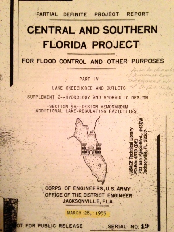
One of the first was the 1955 ACOE Central and Southern Florida Project Part IV. It was a proposal evaluating different options (plans) for “increasing lake outlet capacity. One component was “Plan 6,” a one mile wide floodway extending from the Herbert Hoover Dike to one mile into Water Conservation Area 3. For this report, Plan 6 was the recommended improvement. Dr Gary Goforth notes discharges to the St Lucie would have been lessened about by half, but “not eliminate lake discharges to the St Lucie River.” In the end, the entire plan was not acted upon as many tax payer paid plans are not…but Plan 6 was not forgotten…
Photos taken of 1955 ACOE CSFP Report courtesy of Dr Gary Goforth.Floodway 1955
Various references to Plan 6 and a floodway.
Dr Goforth also notes a “more robust plan,”a plan co-authored in 2009 by Karl Wickstrum, Paul Gray, Maggy Hurchalla, Tom Van Lent, Mark Oncavgne, Cynthia Interlandi, and Jennifer Nelson. (See first photo in this blog.) This plan is referenced by Mark Perry in his well known “River of Grass” presentation.
Mark Perry’s drawing in his presentation for “River of Grass,”used today, 2014.
The Art Marshal Foundation (Art was one of the great conservationist of the early 1960/70s environmental movement and has a wildlife preserve named after him) also notes in their literature that Plan 6 is traceable to the Marshall Plan-1981.
“Marshall Plan 1981 to Repair the Everglades, Why Plan 6 Will Work.” Marshall Foundation publication 2013, Version 2.2.
Most recently in 2013, the Rivers Coalition published on its website “Plan 6 Flowway, River of Grass, Missing Link.”
You can learn more about this version of the plan by clicking on the above link.
All of these plans, I believe, are one way or another based upon the 1955 ACOE Report. it may not have come to fruition but it certainly provided a lot of inspiration!
Also last year, Senator Joe Negron was able to secure $250,000 for a University of Florida study that should occur in 2014 for “Sending more water south.” Wonder what their plan will recommend?
If history repeats itself, even more Plan 6 versions will be created. In any case, let’s keep pushing for change to save the estuaries and find some way to move more water south. And thank you Army Corp of Engineers for the inspiration…
South Florida Developer headline 1931, “Locks in Canal Closed; Fishing to be Benefited. (Newspaper courtesy of historian Sandra Thurlow.)Written minutes from a Martin County Commission meeting in 1931 asking the state to close the locks, mentioning destruction to the river, and the importance to fishing industry. (Photo Martin County archives.)
The St Lucie Canal connecting Lake Okeechobee to the St Lucie River was constructed at the request of the state of Florida, the US Federal Government, and the local Martin County Chamber of Commerce, by the Army Corp of Engineers from 1915-1928. As this antique newspaper article of the Florida Developer above shows, by 1931 the Martin County Commission was already asking the state of Florida to close the gates and reporting clear evidence of the destruction of the St Lucie River/Indian River Lagoon.
I must thank my mother, historian Sandra Thurlow, for sharing this information and the photos in this post. She transcribed the 1931 article from the Florida Developer, a Stuart paper of the era. It reads:
South Florida Developer, November 6,
1931, LOCKS IN CANAL CLOSED; FISHING TO BE BENEFITED
Job of Checking Water Movement Was Completed Saturday TO KILL HYACINTHS; Fishermen Look For Decidedly Good Fishing the Winter
The east locks of the St Lucie Canal were closed Saturday, after being open nearly two years. In that time the level of Lake Okeechobee has been reduced from 18 to 14 feet.
The work of closing the locks began Friday morning under the direction of engineers for the Okeechobee Flood Control District. When they finished the job Saturday night, water continued to pour over the dam about as fast as before, in spite of the fact that the level of the canal had been raised 7 feet.
This morning the crew went to the west end of the St Lucie Canal to close the locks there and thus check the flow of water from the Lake.
The closing of these locks is regarded as highly important to the people of Stuart and adjacent communities, primarily because as long as they remain open, the ingress of water from the Lake made the St. Lucie River fresh, driving out the salt water fish and bringing in hyacinths. With the water cut off from the Lake, it is expected that the St Lucie River will again become salt and this should bring back the fish and kill the hyacinths. Fisherman say it will take about 30 days for the effects of the is change in water to be felt, but they are exultant that this change had come about in time to promote good fishing in local waters.
The minutes from the Martin County Commission meeting in 1931 also shown above are a bit harsher. The minutes state:
Be it resolved that the Board of County Commissioners herby instruct the Clerk to write the Trustee of the Internal Improvement Fund petitioning that they closed the gates at the Lake end of the St Lucie Canal until April 15, 1931, for the reason that the constant discharge of a large volume of dirty fresh water into the St Lucie River has killed all the shell-fish, driven out salt water fish from the river, filled the river with hyacinth and polluted the St Lucie River as to completely take away its attractive features and ruin its commercial value to our community.
According to local Everglades SLR/IRL expert, Dr Gary Goforth, (http://garygoforth.net/resume.htm), 1931 was the first year the amount of water released from Lake Okeechobee in to the St Lucie River was documented. Although there is no documentation of the releases that occurred prior to 1931, in 1931 it is documented that 1,414,414 acre feet of water was released from the lake into the river. This is over three times as much as was released into the SLR from Lake Okeechobee in 2013, (419,951 acre feet.)
The historic photos below document and show local people taking the water hyacinth issue into their own hands.
Downtown Stuart in 1931 showing over abundance of water hyacinth in SLR.(Thurlow collection.)South Fork of the St Lucie River, hyacinth removal, Rod and Gun Club-effort to solve problem with herbicide and dynamite, 1949.( Thurlow collection.)SLR filled with hyacinth, near Treasure Island. (Thurlow collection.)
On August 3rd at 10AM the people of Martin and St Lucie counties, on behalf of their government, will ask one more time for the state to close the gates from Lake Okeechobee to the St Lucie River/Indian River Lagoon.
As we have seen this summer, we have enough problems with our own local runoff that has been expanded since 1931 to include the building of C-23, C-24 and C-25 as well as the widening and deepening of C-44 for its enlarged “local” runoff. Things must change, we have known this for a very long time. Finally there are enough of us to make a difference.
Hope to see you at the rally and may the state and federal government know that we will never stop asking, some would say demanding, that the ACOE, through the federal government and the state of Florida “close the gates!”
West of the red line shows the edge of what was once the Everglades in South Florida. Development has crept and continues to creep over this edge. (Photo/map courtesy of Chappy Young,/GCY Inc. Surveyors, 2014.)
We in Martin and St Lucie Counties make up what is referred to as the “Northern Everglades.” Before the Army Corp of Engineers, (ACOE), changed the course of Lake Okeechobee’s waters in the 1920s and directed it to go east and west through canals to the estuaries, Lake Okeechobee’s water would slowly crest over the southern edge of the lake and flow south. For many, myself included, the long term goal of saving our St Lucie/IRL and Caloosahatchee estuaries includes recreating a type of “flow way, or floodway south” to Everglades National Park. The parched park needs our water just as Nature intended.
There are many challenges to this scenario but the most visual are the following.
The first is the Everglades Agricultural Area, (EAA), 700,000 acres located just south of the lake; the second is east coast development that has crept in over the years “into the Everglades.”
The red colored blocks south of Lake O. are the EAA,700,000 acres of sugar lands, vegetables, small historic agricultural communities, and infrastructure. South of the EAA are the water conservation areas in purple and green. (SFWMD map, 2012.)The red line surrounding Lake O. shows the Everglades wetlands that historically filtered the water before it got to Florida Bay. As we can see humankind has “filled in” a lot of this. (SFWMD map, 2012.)
I have written before about the “seepage barrier” an underground permeable wall that runs along the east coast to keep the water out of these developed areas through pumps that send the seeping water back inside the Everglades. Crazy. If needed, the EAA also pumps its ground water and surface water off its lands to keep the level as needed for the crops. They are assisted by the SFWMD. This is a historic relationship. It is how our state was “built.”
This satellite photo shows in blue the water on lands in 2005. One can see the lands in the EAA just south of the lake are devoid of water. This water has been pumped off the lands into the water conservation areas, sometimes back pumped into the lake, and also stored in other canals. The water would flood the crops if it were on the lands. (2004-2005 SFWMD aerial photography.)
The above photo shows the EAA dry while surrounding lands are wet.
I really do not have an answer of how to build a flow way through all this agriculture, infrastructure, and development as I am not a scientist. But I have not given up the idea. I have faith one day there will not be another choice.
What I confidently can say is that we all know water is valuable, “the new oil.” Water issues whether they be pollution or the need for water usage in a growing state demand attention and we know with the future coming we should not build anything else inside those red lines. No port, no windmill farms, no more development, no more agriculture.
FWC map for 2060 projected population growth, state of Florida, 2011.
If the the Florida Wildlife Commission’s map is right and Florida’s population in 2060 is around 36 million, (today it is 19 million), we are going to need more fresh water. Also if we are to save the northern estuaries and the Everglades so our children have some semblance of what the planet once was, we must redirect more water to go to where it once did, south.
Let’s draw a new line for water. A line that clearly shows we know its value not just to agriculture and development, but to the environment, and the children of the future.
C-44, C-23 and C-24 basin runoff discolors the waters of the SLR/IRL while exiting the St Lucie Inlet 7-19-14. (Aerial photo, Ed Lippisch.)All Photos were taken 7-19-14 and are showing C-44 basin runoff along with C-23 and C-24 runoff off. Pictured are Sewall’s Point and Sailfish Point along the SLR/IRL. Water exits at the St Lucie Inlet going mostly south to Jupiter Island over nearshore reefs. The plume is significant but not as large as the summer of 2013 when the ACOE was releasing from Lake Okeechobee as well. (Photos by Ed Lippisch.)
The river looks awful right now as the photographs taken Saturday, 7-19-14, by my husband show. Why? They are not even discharging from Lake Okeechobee…yet.
We have terrible problems with our local canals and adding the Lake discharges on top of it is a crime. The state, federal and local governments are working slowly to improve the situation through CERP (Central Everglades Restoration Project) projects but improvement is very expensive and cumbersome.(http://www.evergladesplan.org/pm/projects/proj_07_irl_south.aspx)
The C-44 Storm Water Treatment Area/Reservoir the governments are working on now will cost millions of dollars and store only some of the discharges from the C-44 we are getting today. But there must be more. We must learn more. We must keep pushing and helping our governments move along.
The best way to do this is to know how to read the information on water discharges yourself.
Last summer, when the discharges from Lake Okeechobee threw our already ailing river into toxic status, Boyd Gunsalus, one of the the leading scientists (and certainly coolest) at the South Florida Water Management District, showed me how to find the water discharge statistics, and today, in case you do not know, and are interested, I am going to show you.
FIRST THE LAKE AND C-44 BASIN
This link (http://w3.saj.usace.army.mil/h2o/reports.htm) of the ACOE at Lake O. will show you the level of the lake, and whether the ACOE is releasing from the C-44 canal, and or Lake O.
Go to the site above and on the right hand side you will see, St Lucie Lock, S-80 Spillway. Click on it. A chart will come up arranged by dates. (The data is always one day behind.) Look for FLOWS CFS (cubic foot per second) in the 3rd column. Today’s is 260 cfs. : 20JUL14 14.46 0.58 260 0. 00 270 0.0 7 30.07 1018. 2 0.00
Now go back to the same link and look at, Port Mayaca Lock, S-308 Spillway. Click on it. Again look for 3rd column, FLOWS CFS.. Today reads “0.” The gates from the lake to C-44 are not open. 20JUL14 13.55 14.40 0 0.00 270 0.0 9 30.04 1017.3 0.33 0.00
Now if both S-80 and S-308 are open you have to add the numbers together to know how much total cfs are coming into the SLR/IRL. And to figure out how much water is coming in just from the lake, subtract the S-308 number from the S-80 number which will always be larger.
To learn how high Lake O. is go back to the link, go to the chart and hit CURRENT LAKE OKEECHOBEE LEVEL. Today it is 13.66 feet. “Current Lake level is: 13.66 (ft-ngvd)”
OTHER CANALS
OK, now for C-23, C-24 and C-25.
Now, go to this link, the SFWMD’s web site: (http://www.sfwmd.gov/portal/page/portal/sfwmdmain/home%20page) 1. Look for the tab “Managing and Protecting Water;” look under and to the left of this tab for a small title reading “Scietists and Engineers,” click on this and go to LIVE DATA. 3. Go to the top link “Water Conditions-Regional Realtime Data, Status of Water/ Control Gates.” 4. Go to FT PIERCE and click right on the Ft Pierce link. A confusing chart will come up.
Look for these things:
1. S-49. S-49 is the opening for C-24.
2. S-97. S-97 is the opening/gate for C-23
3. S-99. S-99 is the gate for C-25.
Mind you C-23 and C-24 run into the St Lucie River’s north fork and main area and C-25 dumps directly in the IRL at Taylor Creek close to the Ft Pierce Inlet. So C-25 is not coming through the SLR and St Lucie Inlet like the rest of the sludge but it is important to know C-25 too as it is heavily destructive to the IRL.
OK, if you have been able to follow me so far. Once you open the SFWMD pages and get to FT PIERCE and see the weird chart, find the corresponding gate numbers I gave you above, and click on the the second row’s PLOT little box and arrow. Once this opens up, you will see a chart corresponding to discharges that looks like a wave or like boxes. The hight of the box or wave corresponds to a number on the left side of the chart. For instance: Today, S-49 (or C-24) is 450 cfs; S-97 (or C-23 ) is around 350cfs; and S-99 (or C-25) is around 100 cfs.
(I know there are a duplicate gates sometimes but I ignore them and just read one. They seem to say the same thing.)
Now to add up the cfs for “today:” C-23=350; C-24=450; C-44 at S-80 =260; S-308 from lake, 0. Today’s total incoming discharge water is around 1060 cfs cubic feet per second coming into the St Lucie River/Southern Indian River Lagoon.
Last week it was twice or three times this much. The discharges occur after it rains, long after and then finally slow down like they are now.
I do hope this has been helpful and that your head is not spinning or that you can save the links and instructions and try it when you have time. Call me if you have questions and want to learn, 772 486 3818.
It is important for the public to keep up with this and let the ACOE and SFWMD know we are watching what they are doing, so one day I don’t have to choke when I see the tab “Managing and “PROTECTING” water.
Aerial of the confluence of the SLR/IRL off of Sewall’s Point, June 27th, 2014. (Photo courtesy of Scott Kuhns.)
If there is one thing constant about the St Lucie River/Indian River Lagoon’s problems, it is that they are multi-layered and complex. I believe this is one reason it has been so hard to “fix.” If there were just one problem, it would be easier, but there is not one problem, there are many.
So, today I wanted to focus on C-44 basin runoff, again, as it has been in the news a lot, especially the two weeks since I was gone as I heard it really rained and we even got our first named hurricane.
The photo above shows the waters just off of the tip of Sewall’s Point on June 27th, 2014. Disgusting.
Basin map Martin/St Lucie SLR.
The basin map above reminds us of the C-44 basin’s location in southern Martin County. The “basin” is the large area surrounding the C-44 canal in black lines. As we know, this area is largely agricultural and was expanded over the years to drain more land than nature intended.
Through permits with the South Florida Water Management District the agricultural businesses are allowed to use water from the C-44 canal for irrigation when needed, especially during the “dry” season. The Army Corps of Engineers manages the level of the canal mostly for agricultural use; this is an historic relationship. In spite of “best management practices” much of the water used to irrigate their fields, runs back into the canal, over and over again, filled with fertilizers, pesticides, herbicides, etc…This is the untreated, polluted water that goes straight into our rivers.
As we can see looking at the canal map, over the years, the C-44 basin has become tremendous in size in order to drain land for agriculture and development. Millions of gallons of water come off these lands when it rains, as has been the case the past couple of weeks.
This recent photo below by local river activist and fishing guide, Michael Conner, shows what the C-44 basin water looks like when it comes out of the S-80 gates at St Lucie Locks and Dam, the same gates that are used when water is released from Lake Okeechobee when the ACOE opens S-308 at the lake. This can be confusing because usually we associate this type of photo with releases from Lake Okeechobee. S-80 can release just C-44 canal water or “just lake water,” or both lake and C-44 water…
Releases from S-80 from the C-44 canal at St Lucie Locks and Dam, July 2014. (Photo courtesy of Michael Connor.)
So why haven’t we talked about the C-44 basin until this summer, or seen or very much about it in the newspaper “before?”
Well, it is confusing to the lay person, and I don’t claim to know everything, but I will explain what I can.
Generally, in the past, the ACOE did not usually release the C-44 into the river during the summer…but this summer they are. Why?
Well according the the “Environmental Impact Statement (EIS) for the 2008 Lake Okeechobee Regulation Schedule (LORS),” the document the ACOE uses to manage Lake Okeechobee:
“All alternatives assume back flow from the St Lucie Canal, C-44, to Lake Okeechobee to be allowed to occur at lake stages of 14.50 ft or 0.25 from the bottom of the the lowest non-baseflow regulatory zone, whichever is lower.”
Basically this means that under most circumstances if the lake is under 14.5 feet, which it is now, (13.38), the ACOE will “back flow” C-44 canal runoff water into the lake through S-308, rather than sending it east to the SLR/IRL through S-80. This summer the ACOE has chosen not to do this, so we are getting C-44 basin water released into the SLR/IRL so the water looks gross. In the ACOE’s July 11th, 2014, public periodic scientist call email statement, explaining their choices, it reads:
“The Water Control Plan deliberately allow some flexibility to consider real time and forecasted conditions and decisions made within the guidance provided by the Water Control Plan…for the specific decision not to flow water from the C-44 basin into Lake Okechobee since 12 June 2014, the conditions that we took into consideration were rising lake levels, water supply, remaining duration of the wet season and proximity to the low sub band….the 8 July report from the South Florida Water Management District evaluates the condition of St Lucie Estuary and states “salinity at US1 is within the preferred range for oysters in the mid estuary.”
Photo of SLR/IRL off Sewall’s Point yesterday, 7-15-14. (Thank you Ed Lippisch)
Hmmm? Obviously the SFWMD’s salinity report was not that of Mark Perry’s at Florida Oceanographic…Let’s read and take a look.
Mark Perry feels the ACOE should be back flowing the C-44 water into the lake. He says:
“According to the Water Control Plan for the Lake the Corps should be opening S-308 and back flowing this local basin runoff into the lake when the lake is below 14 feet and the C-44 is above 14.5 feet but they have chosen to make steady releases from the C-44 basin through S-80 into the St Lucie at near 1000 cfs since June 14. Not so good outlook for the St Lucie Oysters…”
Please view his chart below that shows what has happened to salinity levels since the C-44 has been flowing into the SLR/IRL. (Mind you C-23, and C-24 are also dumping their basin runoff water, but C-44’s basin area is larger.)
Salinity is going below safe levels for oysters since the C-44 basin at S-80 has been opened.
On the other hand, friend of Mark Perry, Kevin Henderson, long time advocate for the SLR/IRL and founding member of the St Lucie River Initiative, feels the ACOE is perhaps trying a strategy that will help the St Lucie in the “future.” Kevin states:
“I firmly disagree that the Corps should always run C-44 drainage west until the Lake reaches 14.5. That is the pattern that gets us the most continuous lake and C-44 drainage into the fall, and the the patten that kills oysters…It is not basin runoff that kills the estuary, it’s months of continuous discharges at rates that never let salinity recover. This is why I advocate sending C-44 drainage west only when local salinity could recover for a while, then send it east again and do not let Lake O get high enough to wreck us with longer term discharges…”
I think he’s saying, the ACOE, by not consistantly filling the lake up with C-44 basin water during summer, may be avoiding long term runoff into the SRL/ILR in the future come fall…
Hmmm?
Both Mark and Kevin have a point.
My non-scientific perspective?
I think the ACOE was so taken aback by the wrath of the general public last year, the River Warriors, the River Kidz, the River Movement, the Stuart News/media, as well as some politicians, that they will do “almost anything” not to release water from Lake Okeechobee into the St Lucie River/Indian River Lagoon if they don’t have to.
By letting the C-44 basin water go into the river and not the lake, if a hurricane comes, there is just that much more room in the lake to hold the water so they don’t have to dump here and listen to us scream….
Historic postcard, Indian River Citris. (Collection of Sandra Henderson Thurlow.)
Thousands of years ago, humankind found a way to avoid the constant nomadic life of following big game, becoming more self sufficient, learning the art of agriculture. Nothing has made our lives better. Unfortunately, after thousands of years of its evolution, nothing has made our lives worse.
Don’t get me wrong, I realize that agriculture an important industry, the second largest after tourism, in the state of Florida. Still, we must look at its issues and try to make things better.
Agriculture is a high intensity land use, using large amounts of pesticides, fertilizers, and fungicides that over time accumulate in the water and the environment. The May 2014 issue of National Geographic states that “farming is the largest endeavor on earth using just under 40 percent of the earth’s surface causing the second largest impact to the earth, erosion.”
Much of the land in our area is devoted to agriculture as well, particularly citrus.
The Indian River Lagoon region is famous for its delicious citrus and although the industry is in decline due to canker, it has had huge impacts on the IRL area due to the canal system built to drain the land and water the crops. The muck that has entered the lagoon since the early 1900s is mostly from erosion of canals, due to the runoff from agriculture as they drain their lands that were once swamp or wetlands.
The Indian River Lagoon Region runs from Palm Beach to Volusia Counties, along the 156 miles of the lagoon. (USDA map 2011.)
The USDA documented 89,367 acres of citrus in the Indian River Lagoon region in 2009, declining to 81,673 in 2010. There is a lot of land devoted to citrus, land that has been radically altered from its original state and affects the Indian River Lagoon as there are literally thousands of miles of canals attached and interwoven along these groves. All eventually dump to the river or other water body.
In 1994 the Florida Department of Environmental Protection (FDEP) determined that the north fork of the St Lucie River/Indian River Lagoon, a registered state “Aquatic Preserve,” was contaminated by pesticides that came from the citrus groves in the area of the St Lucie’s headwaters, Ten Mile Creek. (http://www.dep.state.fl.us/southeast/ecosum/ecosums/tenmile_creek.pdf)
In 2002, the Florida Department of Environmental Protection labeled the St Lucie River as “impaired.” Reading through the document there is clear determination of agricultures’ role in this process, especially with sediment run off, pesticides and heavy metals that have accumulated in the environment. (http://www.dep.state.fl.us/southeast/ecosum/ecosums/SLE_Impairment_Narrative_ver_3.7.pdf)
All postcards of citrus industry in Florida, ca. 1912. (Collection of Sandra Henderson Thurlow.)
Reading through the documents it is noted that many of the agricultural areas are quite old, as the post cards I am sharing today from my mother’s collection are from 1912 and 1914. According to the FDEP, many of the areas around Ten Mile Creek did not have BMPs, or best management practices in place, as they were there before such rules were voluntarily implemented in the 1980s and 90s.
I don’t get it. Our environmental agencies have seen the writing on the wall for decades and even with the modern implementations of BMPs, (http://solutionsforyourlife.ufl.edu/hot_topics/agriculture/bmps.html) where farmers try to minimize their impacts on our waterbodies, the rivers, estuaries, and lakes are filling up with excess nitrogen and phosphorus from fertilizer and other pollutants at an alarming rate.
Yes, the FDEP is implementing TMDLs or total maximum daily loads through the BMAP, or basin management action plan, where municipalities and counties are required to lower their nutrient levels in waterbodies, but these are 15 and 30 year goals, that most certainly will take longer to truly implement. Also agriculture is exempt under the law and Right to Farm Act. They, as mentioned, implement BMPs but it may take fifty or more years to get all farms up to speed, if ever. Do we have that much time?
In the meanwhile, we watch or rivers dying from local runoff from C-23, C-23, and C-44 supporting the citrus and agriculture industries in Martin and St Lucie Counties. On top of this, during major rain events, Lake Okeechobee, also full of agriculture runoff and high nutrients suspended in muck, from the sometimes back pumping sugar industry south of the lake, pours into the St Lucie River as well, wreaking any work we have done locally to meet local TMDLs.
Would I rather see the citrus lands developed for houses?
No. I rather fix the problems we have. And even though its called “corporate welfare,” I think state, federal, and local governments must help agriculture operate in a way that is not killing the environment. Some of the funds from the state this year that came out of the Senate Hearing on the IRL are doing this and the state really has been helping “forever,” but quietly, under the radar.
It is time to come full out to the public and explain the situation: we must feed ourselves and support our historic industry, but agriculture/citrus is killing our waterways.
In conclusion, of course the industry should make every effort itself to improve the situation, and some are more than others. In any case, we cannot just point fingers at them, we must help them. Perhaps we should bond together and put into law even better, stricter management practices, that will give the children of our state a future, not just eating, but also fishing, swimming and boating in a clean river.
Harold R. Johns, posing with a large tarpon, early 1920s, Stuart, Florida, St Lucie River. (Photo from Stuart on the St Lucie by Sandra Henderson Thurlow.)
When the pioneers permanently opened the St Lucie Inlet in 1892, it killed the freshwater grasses that filled the waterways creating a brackish estuary that due to the convergence of tropical and temperate zones, and the nearby warmth of the Gulf Stream, became “the most diverse estuary in North America.” (Gilmore)
After a short period of time, sportfishing thrived in the area, and fishing guides called Stuart the “fishing grounds of presidents” as US president, Grover Cleveland, vacationed and fished the area in 1900 and years after.
In spite of long standing issues with the health of the estuary, as late as the 1970/80s Dr Grant Gilmore of Harbor Branch documented over 800 species of fish living and breeding in the then healthy seagrasses around Sailfish and Sewall’s Point at the convergence of the St Lucie River and Indian River Lagoon. This was a larger variety of species in one place than any other area in United States. (Gilmore)
“Goliath Grouper” called “Jew Fish” at the time, Stuart. ca. 1920s. (Thurlow Collection)
Going back to the the 1930s, the 1938 Blue Book, a popular annual fishing publication of the time, lauds fishing throughout the entire Stuart area:
“The City of Stuart located approximately 20 miles south of Fort Pierce is world renowned for its fishing. Located as it is…it offers a variety of fishing similar to Fort Pierce but somewhat more pronounced, particularly with regards to the tarpon, sea trout, snook, channel bass, bluefish, crevasse jack, pompano and ladyfish. It’s fresh water fishing is particularly good far into the back county among the Sloughs with their tributary and drainage canals to Lake Okeechobee and the many drainage canals through this territory. These Sloughs and Canals offer splendid fishing for black bass, as well as for the larger game fish from the salt water, such as th snook and tarpon, that make their way into Stuart Harbor and on up into the both and south branches of the St Lucie River. –Particularly good fishing for these species can be had at the St Lucie Locks about 12 miles inland south of Stuart…”
All photos from Stuart on the St Lucie, Sportfishing chapter, by Sandra Henderson Thurlow.
It is interesting to note that although the Blue Book piece, written in 1938, celebrates Stuart’s fishing, one can find evidence of tension regarding the releases from Lake Okeechobee in the literature of the day as early as 1925.
Fearing the onslaught of development in the booming twenties and the changes brought on by the connection and building of the C-44 canal from Lake Okeechobee to the South Fork of the St Lucie River, beginning in 1923, the South Florida Developer’s, November 10th, 1925 headline reads:
Article 1925, South Florida Developer. (Thurlow collection.)
“Fish Will Leave the River As City Grows, Fisherman Assert, Sewage and Oil Sure Death to a Favored Sport is Verdict.”
The article quotes commercial fishermen who know that the over abundance of fresh water from Lake Okeechobee will chase away the salt water fish and that the oil on the water from development, perhaps from cars and road runoff, if excessive, won’t allow the fish to sufficiently breathe.
Fishing guide Phil O’Brian is quoted as saying: “I know the ways of the sea fish. They can’t stand fresh water; and they won’t stand sewer water. We have the fresh water now mixin’ in from Lake Okeechobee and we’ll soon have the sewer water.”
These pioneers are probably rolling over in their graves should they have learned about the story of the St Lucie/Indian River Lagoon most recently.
The St Lucie River was labeled “impaired” by the Florida Department of Environmental Protection in 2002 mostly due to pesticides and heavy metals from agriculture and urban pollution runoff accumulating in the sediment from all area canals, especially C-44 and Lake Okeechobee. In a way, just like the 1920s fisherman foresaw…
The fight against the area canals and Lake Okeechobee continues today, and if by the grace of God we can undo some of the hands of history, the St Lucie and Indian River Lagoon will surely heal herself and we once again could be the ” Fishing Grounds of Presidents…”
…but then we might have to get rid of that green and sprawling golf course at the Floridian.
The S-80 structure at St Lucie Locks and Dam. C-44 canal in background goes miles to Lake Okeechobee where the S-308 structure is located at the eastern edge of Lake O. (Photo Scott Kuhns, 2013)Drainage basins into the St Lucie River, note C-44 south. (SFWMD, 1999.)
The locks are back in the news again. WPTV, “hard working for the river reporter,” Jana Eschbach, broke the story yesterday, that the Army Corp of Engineers did not alert the public that they would be releasing polluted canal, C-44 basin water through the S-80 structure into the St Lucie River. Jana, like most people, feels that the public should be alerted when polluted water will be coming into the estuary in that we swim and fish. She is also concerned the water in the area of Palm City and the Roosevelt Bridge, which has been reported to have high levels of bacteria, will be pushed to the popular Sandbar area.
This can be confusing. Don’t we just care about lake water? Also, if the locks are open, doesn’t that mean the ACOE is releasing Lake Okeechobee water? Not necessarily, and the basin water can be just as damaging to the estuary and the public. So how does releasing basin or lake water work?
There are two structures along the C-44 canal which runs along the side of Highway 76 from the South Fork of the St Lucie River, to Lake Okeechobee: S-308 at the edge of Lake Okeechobee, and S-80, 20 miles or so, east, at the St Lucie Locks and Dam.
This ACOE canal and structure map shows S-308 at Lake O. and S-80 along the C-44 inland.
S-80 serves duel purposes. First to release water through Lake Okeechobee, but only if S-308, at the lake, is open first, allowing water into the C-44 canal. Then S-80 lets the water pour into the St Lucie River.
Second, S-80 can be opened just to allow water from the C-44 to flow into the St Lucie River, as the C-44 canal is surrounded by a 185 square mile basin, mostly agriculture, that has been directed to flow into the canal when it rains. Agriculture also uses this water in the C-44 canal to water their crops. To make things more confusing, C-44 can “deliver” local basin runoff in both directions: to Lake Okeechobee and to the St Lucie Estuary. The ACOE decides where the water “needs” to go by opening and closing the structures of S-308 and S-80.
It must be noted that the water from the C-44 basin is polluted, as is the water from Lake Okeechobee. The Florida Department of Environmental Protection writes: “…the construction of the C-44 canal has had the greatest impact of the St Lucie Estuary–and nearly all of that impact has been bad, FDEP 2001.) The charts below show how much nitrogen and phosphorus come into the river from the C-44 and other basins. C-44 is the highest. Phosphorus and nitrogen mostly from fertilizer, feed toxic algae blooms in the hot summer months.
Similar charts shows amounts of nitrogen and phosphorus runoff into the SLR. Note C-44 basin is the highest. (SFWMD, 1995.)
Fortunately, there is good news due to the help of our local, state and federal governments. The almost 3 billion dollar “C-44 Storm Water Treatment Area/Reservoir” has received first stage fundings and is under construction in Indiantown. It has been since 2011. This reservoir will hold the release water from the C-44 basin and clean it before it is returned to the St Lucie River. This is a huge positive, although it will not stop the releases from Lake Okeechobee.
An educated public is the best defense against the continued destruction of the St Lucie River/Indian River Lagoon. Thank you for being part of the solution and hopefully, next time, the ACOE opens any structure for any reason, they will alert the public, because here in Martin and St Lucie counties, we want to know!
Florida League of Cities, 2014. (Photo FLC/Negron)
Senator Joe Negron, Senate Appropriations Chair, and leader of the “Senate Hearing on the Indian River Lagoon and Lake Okeechobee,” brought home more money for the IRL compared to any other water body in the state: $231,998,021. Our springs comrades who have been publicly fighting ten years longer than us, brought home 30 million. Tallahassee is wondering who this new kid on the block is, us….
Whether you are a fan or not, it must be noted that Senator Negron stuck his neck out, possibly compromising his senate presidency, to get our “name on the map” as far as Tallahassee goes. Prior to last year, most “good ‘ol boys in Tallahassee would have said, “Indian River Lagoon…Hmmmm? Creature of the Indian Lagoon, ain’t that a movie?”
Nonetheless, I do not pretend to think that these monies alone will cure the lagoon’s ills, as the gorilla in the room has not been addressed “head on and in its entirety:” the releases from Lake Okeechobee through S-308 and S-80. I believe this will come in time if we keep fighting.
In my opinion, the biggest part of change is the first step. With the outrage of the public over the “Lost Summer’s” toxic St Lucie River and Indian River Lagoon, and the support of Senator Negron, one of the few people in a the legislature with the seniority and status to act somewhat independently of demanding party pressures to conform, we have taken the first step forward to fixing the lagoon. Actually, a leap.
WE MUST CONTINUE, YES! But let’s be happy that we have made public progress on a state level more than ever before, and let’s look at what we received, as we should be aware of the gift of public monies from people all over our great state and be full of gratitude.
It’s a lot to go over, but it is important, so I will simply go down the list and summarize. Let’s look at the map as well. Please remember the SLR/IRL is part of the greater Everglades system, from the Kissimmee River area in Orlando, south to the Tamiami Trail in Dade, and beyond to Florida Bay. So anything done to help “the system,” helps us move water south, and with our health as well.
IRL/L.O. Fascility and Infrastructure Location Map Index, 2014. (Senator Negron’s Office)Key to stars/locations on map.
Here we go!
1. $32,000,000 for Water Quality storage in Storm Water Treatment Area 1 in Palm Beach County. Water storage is key to stop releasing so much into the estuaries.
2. $3,000,000 for Best Management Practices (BMPs) for farmers in the St Lucie, Lake O, and Caloosahatee watersheds. It is difficult to swallow more public money going to help farmers with pollution runoff, but there is no other way to do this. We must continue to help fund them, big or small. This is a historical issue as they have been here since the 1800s in many cases. I look at it like “grandfathering” with an extra requirement, as in real estate. The good news is that as time goes on, agriculture businesses will have higher standards to avoid pollution fertilizer, pesticides and fungicide runoff that is killing our waterbodies. Hopefully we can make changes before the rivers and springs die off completely.
3. $40,000,00 for the C-44 Storm Water Treatment Area/reservoir in Martin County. This will offset local drainage farm and urban runoff along the C-44 canal, not water from Lake Okeechobee. We must clean our local runoff as well as it is responsible for around 50% of the destruction to our estuary and on an everyday basis.
4. $2,000,000 CERP Picayune Strand east of Naples in Collier County. This area is important to the southern glades and needs monitoring and vegetative management for water flow and storage and improvement. Hopefully it will help some panthers too!
5. $5,000,000 C-111 South Dade. This is a crucial water delivery system to allow more water to “go south.” A must.
6. $5,000,000 Kissimmee River Restoration. The all time worst thing ever done in Florida other than dike Lake O and redirect the water to the estuaries, was to straighten the Kissimmee River. (Hold my tongue!) Restoration of the ox bows must continue. So far the ACOE has restored about 22 miles of the 56 miles of what was once 153 miles of gorgeous serpentine like, vegetative, wildlife filled, cleansing waters.
7. $18,000,000 C-43 STA along Caloosahatchee River. This is the equivalent of C-44 STA/reservoir for the Caloosahatchee. Only fair. C-43 is a must. They take up to three times the polluted runoff from Lake Okeechobee that we do!
8. $20,000,000 IRL muck removal in northern lagoon. The northern IRL has lost 60% of their seagrasses and has 2 Unexplained Mortality Events including manatee, dolphin, and pelican die offs. Give them what they need! Sediment/muck fills the lagoon over the years from canal runoff covering seagrasses; when stirred up, it releases legacy pollution. GET THE MUCK OUT!
9. $2,075,000 Lake Worth Lagoon. Lake Worth does not get the attention it needs being in development happy Palm Beach County. This area was once full of sea grass and life but not after years of receiving dump water from Lake O, like us, but through a different canal. Local advocate, Lee Shepard, is a great advocate for this part of the lagoon. Let’s help!
10. $4,000,000 Water Quality research for Harbor Branch and ORCA. Although it is hard to justify “more tests,” as we can all see the lagoon is dying, these new, scientific studies will help us find sources to our pollution issues that the legislature can’t ignore. Septic leakage, especially, is difficult to trace without such systems. LOBOS and Kilroys, please help us!
11. $1,000,000 Oyster recovery programs for St Lucie and Caloosahatchee Rivers. Millions of dollars worth of oysters, natural and deployed by government programs, died during the fresh water discharges of 2013 and years before. One oyster can filter 50 gallons of water a day. Government in action….
12. $90,000,000 NUMBER ONE NECESSITY is raising the Tamiami Trail in Dade County so water is not blocked off from going south. They should raise the whole road as the road built in the 1920s cuts off the flow of water south to the Everglades for the entire state. (Another environmental nightmare to fix.)
13, $2,7769,585 This money will be used for pump improvements etc to move more water south and cut away vegetation blocking water “going south,” or hold water in the C-43/44 reservoirs that would go into the estuaries.
14. $2,076,728 The Loxahatchee is one of two “Wild & Scenic Rivers” in the state of Florida and home to tremendous amounts of wildlife. Helping with storm water runoff and preservation is key for the health of this important part of the Everglades System.
15. $2,076,718 The St Lucie Rivers Issues Team has a long history of working with local governments for “close to home” projects along the SLR/IRL. Kathy LaMartina at its helm, South Florida Water Management District. Thank you!
Grand total= $231,998,021
I am grateful to the state legislature, especially Senator Negron, and I must note Governor Scott did not veto one line. But please know everyone, the “fight for right” along the Indian River Lagoon has just begun!
This chart shows that even though more Storm Water Treatment Areas (STAs) came on line (red) in 2004, actually less water is “going south,” (blue). Why? (Chart by engineer, Dr. Gary Gorforth, formerly of the SFWMD, 2014.)
The first time I saw Gary Goforth speak (http://garygoforth.net/services.htm) at Senator Joe Negron’s Senate Hearing on the Indian River Lagoon and Lake Okeechobee in 2013, I was very impressed. He was sitting next to Karl Wickstrom, the founder of Florida Sportsman Magazine, who I sit with on the Rivers Coalition Defense Fund. I knew if Dr Goforth had Karl’s “blessing” he belonged to an elite group of people in the River Movement, as Karl, who I love, is understandably critical of everyone.
I came to learn that this accomplished and well spoken man, had worked at the South Florida Water Management District (SFWMD) as a Ph.D. engineer, most of his esteemed career and in fact “built” the Storm Water Treatment Areas (STA) in the Everglades Agriculture Area (EAA) as head engineer for the district’s projects in 2004 on onward. Today he runs his own engineering company here in Martin County independent of the district. (See link above.)
Map south of Lake O. showing EAA, canals, STAs, and Water Conservation Areas, (WCAs.) (Map SFWMD, public.)
An STA is an area that filters water through vegetation taking up nutrients like phosphorus and nitrogen and even pollution before it goes into a water conservation area and then to the Everglades. It is an area engineered to do what Mother Nature did before we transformed her into farmlands and urban landscapes.
Aerial of STA in EAA surrounded by sugar fields, northern area. (Public photo.)
When the Everglades Forever Act was passed by the Florida legislature in 1994, and after Governor Chiles “laid down his sword,” the SFWMD was required to build more STAs to filter the polluted water running into the Miccosukee lands and Everglades further south. The Miccosukee had sued the US government and the SFWMD, (a long, famous lawsuit starting in 1988), as specifically the high phosphorus from fertilizers and pollution from the EAA’s sugar farms was destroying their reservation’s waters and fauna and therefore all that lived there. The law suit accomplished two major things. It called for 10 parts per billion phosphorus rather than 200 plus so the STAs were built and it called for a certain amount of water to go south to sustain the life of the Everglades.
So in comes the law regarding amounts: In chapter 3773.4592, Florida Statues, “1994 Everglades Forever Act” the SFWMD was directed to send an additional 28 % water to the Everglades, including 250,000 acre feet of Lake Okeechobee water based on base flow statistics from 1979-1988. The Everglades needs water to live.
It is confusing, but although the STAs can send both EAA water and lake water south to the Everglades, the SFWMD gives the EAA water (from the lake, used to water their crops), priority in moving south. Lake water goes south only if the STAs have room….
OK. Here is the kicker.
Although in the recent past, the EAA spent tons of money removing toxic chemicals from the lands they had to give up for STAs and although the tax payers spent billions of dollars building the STAs on those lands for cleaning EAA water and Lake Okeechobee water, Gary Goforth’s charts and engineering show that since 2004, actually less lake water is going south to the Everglades. And most of the water going south is EAA water, very little Lake water comparatively ….Why?
Well, from what I think I understand, even though all this money has been spent in the EAA and tax payers building the STAs, the EAA and SFWMD who work together, are “scared” to send too much water south because if they go over the 10 parts per billion phosphorus limit (an annual limit) they could be sued again. Thus they hold the EAA water in the STAs letting it dribble out and therefore there is no room for Lake O’s water most of the time.
Hmmm?
As Dr Goforth points out, it is the St Lucie River and Caloosahatchee that do not get what was legislated for them: a minimum of 250,000 acre feet of lake water sent south a year.
As stated in an email to me:
“The 1994 Everglades Forever Act (Florida legislation Ch. 373.4592, F.S.) directed the South Florida Water Management District to send an additional 28 percent water to the Everglades, including 250,000 acre feet of Lake water. The 1979-1988 base period flows to the Everglades included an average of 100,931 acre feet from Lake Okeechobee – resulting in a targeted increase of Lake water to the Everglades of 148 percent.
For the most recent 10-year period (May 2005-April 2014) an average of 71,353 acre feet of Lake water was sent to the Everglades – or an average decrease of 29 percent from the 1979-1988 base period.
So – the target was a 148 percent increase – and the reality was a 29 percent decrease. This was in exchange for a billion dollars of public funding for the STAs. Who holds the State accountable?” Gary Goforth
Another chart showing the same ideas.) (Gary Goforth 2014.)
If you are like me, this all may remain confusing, but I think the point is made… I hope so anyway.
“Legally, not enough Lake O water is going south.”
This is a serious situation. Really, only the people can hold the state accountable, but do we really want to sue again? Can this be resolved?
Many say it is impossible to send the water south at 10 ppb. This may be the case. Nonetheless, I say the Miccosukee Indians finally won something after generations of sadness to their people, after being forced to live on a postage stamp, so as “tough as it sounds,” I believe the EAA, the SFWMD, and the state of Florida have some more work to do.
Girlfriends from the Martin County High School Class of 1982 celebrating our 50th birthdays in Sanibel/Captiva, the area of the Caloosahatchee River, Lee County, Florida.
This past weekend, my girlfriends from high school decided to travel across the state to celebrate our 50th birthdays!
It was a great time. We stayed in the area of the Caloosahatchee River which is the sister river the the St Lucie River. Both rivers have been plumbed to take overflow waters from Lake Okeechobee that Nature meant to flow south to the Everglades. The Caloosahatchee, in fact, is the “bigger sister,” in that when the rains come, she takes three to four times as much polluted, fresh water as we do—she is longer and larger than ourself. Ironically now, year long, the river needs constant small releases of fresh water from the lake as she becomes too saline. The system is suffering as is the St Lucie.
Caloosahatchee River was the first estuary to be channelized and connected to Lake Okeechobee in the late 1800s by Hamilton Disston. (Photo, CRCA)
“Caloosahtchee” means “river of the Calusa,” after the native peoples who lived and thrived there thousands of years ago.
So how does the Calooshatchee compare to the St Lucie? Well, according to the Caloosahatchee River Citizens Association, (CRCA), as sea levels receded after the last ice age, a series of lakes connected by wet prairies fed a tiny lake in the center of a valley feeding a “tortuously” long, crooked river that flowed slowly west to the Gulf of Mexico. So the Calooshatchee like the St Lucie drained to the sea but was never “connected” to Lake Okechobee.
But then entered “modern man.”
In 1881, investor and business man, Hamilton Disston, bought four million acres of Florida lands for development and agriculture getting the state out of debt. His first project was to drain the land around lake Okeechobee.
He dynamited the water fall between Lake Flirt and the Caloosahatchee and connected an old Indian passage from the Caloosahtchee to the lake. With that and the dredging and channeling of the mouth of the Kissimmee, the lake dropped tremendously, and although Disston committed suicide in a bathtub after the Panic of 1893, he inspired those following him to continue the drainage machine that has formed the Florida we know today.
After the floods and hurricanes of 1926 and 1928 the Caloosahatchee was straightened, deepened, and widened, draining surrounding agricultural lands and controlling flood waters. The “improvements” continued again in the the 1950s as more people moved into the area.
The story of the Calooshatchee is very similar to the St Lucie.
On another note, one of the most interesting parts of getting to the Caloosahatchee with my friends was driving “under” Lake Okeechobee taking Highways 441, to 80, to 27 and passing through the sugar towns of Belle Glade, South Bay, Clewiston and La Belle. It was a three and a half hour drive from Stuart to Captiva and most of the drive was through the Everglades Agricultural Area.
The Everglades Agricultural Area (EAA) is 700,000 acres south of Lake Okeechobee. To drive through them one drives just south of the lake.
As we were driving through we were amazed to think that historically the waters of Lake Okeechobee went south, as today, south of the lake, it is sugar fields for as far as the eye can see! And for many, many miles you are driving right next to the dike.
“This is kind of weird…”
Mile upon mile of sugar fields is the view while traveling south of the lake.Southern dike around Lake Okeechobee looks more like a hill of grass.
I reminded my friends of the hurricane of 1928 and the thousands of migrant workers that were killed with no alert of the coming doom. The small dike around the southern lake certainly did not look like it would hold if another monster storm came. We talked about how clueless we were as kids to the environmental effects of agriculture on our St Lucie River/Indian River Lagoon compared to what the children are learning today.
Of course we need agriculture but to have 700,000 acres completely cut off water flow south of the lake is an accident waiting to happen and a death sentence for our St Lucie Indian River Lagoon and for the Caloosahatchee.
As I talked about a possible third outlet to the lake, I told my friend Jill not to speed because if we were stopped, and I was in the car, we would all certainly go to jail!They laughed knowing I am an advocate for the St Lucie/Indian River Lagoon an often contentious issue when it comes to sugar farming.
Once in Captiva, we had a great time, paddle boarding, riding bicycles, swimming, and going out in Sanibel/Captiva Island.
Such a wonderful time would not have been possible had the Army Corp and South Florida Water Management District been releasing masses of polluted, fresh water from Lake Okeechobee. United we are on both sides of the state, that there has to be another option for Lake Okeechobee’s water coming through our estuaries–we are sisters!
A beautiful sunset over the convergence of Pine Island Sound and the Caloosahatchee , our sister river.
The delay of CEPP, the Central Everglades Planning Project, may end up symbolically being the beginning of Florida’s 4th Seminole War as people fight for water to move south. (Photos public.)
I really did not want to write about the failure of the Central Everglades Planning Project, CEPP, as I have been trying to forget about it. The whole thing is so depressing to me. However, last night, before I went to bed, my husband said, “Dan thinks you should write about what’s going to happen now that CEPP did not make it into the WRDA bill…” So, I had a long series of nightmares, now it’s morning, and for Dr Daniel Velinsky, I will do the right thing, and try to write this piece.
First some history.
It is well documented that Florida’s three Seminole Wars were the longest, bloodiest, and most costly of all the Indian wars fought by the United States, fought on and off between 1814 and 1858. In the end, no treaty was signed and the few hundred remaining native peoples hid in their well known Everglades swamp to resurrect themselves as today’s Seminole, Miccosukee, and unaffiliated Independent Seminole Tribes.
They never surrendered and today their successful 1980s/1990s law suit against the Federal Government and the State of Florida requiring the polluting of Everglades Agricultural Area run off water onto their lands, to be reduced from sometimes over 300 to 10 parts per billion/phosphorus, in my opinion, is a key reason, along with its tartiness and other issues, why CEPP was not included in the Water Resources Development Act, WRDA, bill by the U.S. Army Corp of Engineers.
I can hear the D.C. ACOE now: “Even if we had the designated land, the mass of water could not be sent south—it’s too dirty. We need so much more land to clean it. So we’ll build all this structure but we won’t be able to send but a dribble of water south…Florida has to lessen the water quality requirements or …”
Well first of all, I say “kudos” to the Seminole and Miccosucci for holding the state responsible for cleaning up its water, even if it is an”impossible” number to achieve under present circumstances. I’d say in the karma department, “we had it coming.”
So now what do we do? Well in my opinion a type of war is going to start, and I liken the people of the St Lucie River/Indian River Lagoon to the “Fourth Indian War Warriors.” We will not surrender.
The failure of CEPP to pass will historically be the beginning of this war. And like the Indians of the 1880s, we were indirectly lied to, and part of it was our fault for believing what we were told, knowing the facts of history.
We all watched and participated along with the South Florida Water Management District and the Jacksonville Army Corp of Engineers for three years, putting full concentration of resources and creativity– forcing dedicated staff from both agencies to produce a document, CEPP, that the US Army Corp of Engineers more than likely knew, would never make it. So now, “they” want us to continue rallying for another two years for next WRDA bill. “Oh sorry maybe it will be seven years….”
I don’t think so.
Guess what? The people are tired of waiting. They put their money on the state and federal governments’ horse, and our horse wasn’t even allowed to run.
Do you feel the chain pulling and digging into your neck? I do.
This tactic is not new, and honestly I think it is simply part of a dysfunctional federal and state government. Let’s look back.
In the 1990s governor Lawton Childs had the state halt the famous water quality law suit and actually “laid down his sword” in a courtroom-how courageous, but look where we are now; in the mid 2000s Charlie Christ’s “Sugar Land Deal” was downsized due to the Economic Crisis of 2008 and other politics; before that, Jeb Bush started the “Acceler8 Program to quickly complete eight of over 60 Central Everglades Restoration Plan’s (CERP) projects. The SFWMD, functioning under the governor, worked diligently like they did recently for CEPP–the eight projects were not completed; and since 2011/12, under the Rick Scott administration, the entire focus was on CEPP, which also would have bundled some of the CERP projects to begin “moving faster” and to “move the water south.” After years of laser like dedication, for now, the project is “dead.”
Florida has water quality and quantity issues brewing like a hurricane, and our Indian River Lagoon area will be the eye in November of 2014, as former governor Charlie Christ runs against Governor Rick Scott. The race would have been messy anyway, but now it is going to be war as the different sides configure how to “send the water south” with out CEPP. Start thinking about how you want to send the water south or stored, and “never, never, never give up.”
A portion of the restored Kissimmee River. Note discolored and filled C-38 canal juxtaposed to winding restored, greener oxbows. (Photo Jacqui Thurlow-Lippisch, 2014).
Last week, on a hazy smoked filled afternoon, Ed and I flew over Lake Okeechobee and the once mighty Kissimmee River. There was the normal stress involved with me giving Ed directions and the fun of an adventure. It went something like this:
“Oh there it is, the Kissimmee’s opening to the lake, over there!”
I can’t fly north of “over there,” it’s off limits; it’s a near a bombing range or air force base…” says Ed, shooting me a serious glance.
“What a bombing range-air force base? You’re kidding, close to of some of the state’s richest wildlife habitat? How symbolic…”
Ed rolls his eyes, I can feel it. But he tries harder…
Somehow, Ed talks to Miami Air Traffic Conrol and we get lucky. It is a Sunday and we are allowed to fly over at least part of the area I wish to see.
On the way, we fly over the southwest area of the lake’s agricultural lands. The hand of humankind is reflected in organized, perfect sized boxes of agriculture and straight canals.
We veer off to the northwestern area of the Lake Okeechobee where earth and water meet; on this side of the lake the hand of the Creator still evident. Little specks of light blend together in a blinding symphony of light.
We near the area in Okeechobee County where the mouth of the once great Kissimmee meets Lake Okeechobee. The straightened canal looks out of place among the lush greenery and a small town is evident. There are people here. Flooding is an issue.
It is great seeing “it all” from above as I have never really been able to figure out on a map where the Kissimmee River restoration is happening. It starts about 20 miles north of the lake.
The Kissimmee river was once 103 miles of wildlife/fish filled meandering oxbows, but it was canalized to a depth of 30 feet as C-38 from 1962-71. This was part of the Army Corp of Engineers and the Central and South Florida “Flood Control Project” of 1954. The state had asked for help after two back to back hurricanes and wide spread flooding and destruction in 1945. The state got help but with untended consequences…
The Kissimmee River that once meandered south to Lake Okeechobee as part of a two mile wide flood plane now shot down to the lake with grave environmental effects that included the destruction of the estuaries, St Lucie/Indian River Lagoon and Caloosahatechee.
Since 1994, around 23 miles of the now 56 mile long canal, C-38, from Lake Kissimmee to Lake Okeechobee has been/is being backfilled and considered part of “the” most ambitious environmental restoration project in the world.
Recently, the ACOE and SFWMD have been in a dispute over the completion of the restoration project. The project is tremendously expensive requiring federal and state funding which has not come easy since 2008. The two agencies “cost share” in its completion. Word is they are “working things out…”
The long term goal is to continue the restoration of at least 20 miles more of the 56 miles of the canal.
In light of the dying Indian River Lagoon, it is important to see that restoration can be accomplished. Mother Nature is quick to rebound once given the chance.
The Kissimmee’s restoration is critical, as the polluted waters coming from Orlando south carry sediment, and urban and agricultural runoff into the lake. As we know, when the lake gets too full the water is diverted to the estuaries because the water is not presently allowed to flow south, as the EAA (Everglades Agricultural Area) is located there along with cities of people.
So we here along the St Lucie Indian River Lagoon, are fighting a two front war. One north and the other south of the lake. We are winning in the north because the ACOE and SFWMD recognized their/our mistakes, and have been working since 1994. We are also getting closer in the to finding a safe way to “move the water south…” CEPP (Central Everglades Planning Project) is not looking good right now, but the pressure is on, and even Tallahassee is saying “move the water south!”
We must have inspiration or we will never complete our goal of saving the estuaries. The Kissimmee River is a place to look and find hope.
2014 Google Earth map of restored area of Kissimmee River.
Topographical map of EAA showing elevations. CEPP would move approximately 15% of Lake Okeechobee’s overflow water south and build a basis for future increases, rather than sending all water through the northern estuaries. By means of canals in the EAA and other structures, this water would be cleaned and then directed to the Everglades. The ACOE refused to sign off on CEPP 4/22/14. (Map courtesy of INTER-MAP via Kevin Henderson)
CEPP=Central Everglades Planning Project, 2014,( contains elements of CERP); CERP=Comprehensive Everglades Restoration Plan of 2000.
To every action, there is a reaction, and in the case of the ACOE refusing to sign off on CEPP, the reaction here in Martin, St Lucie, and Lee County across the state certainly will not be “good.”
Mind you there is a Jacksonville ACOE, who works with “us” and then the ACOE in DC. They are the same but different…
Let’s start at somewhat of the beginning so we can get a grip on this always terribly confusing, multi-layered attempt to fix our estuaries and restore the Everglades.
Around 2000, long before I was involved with the River Movement directly, a group of Florida stakeholders, including environmentalists, the agriculture industry, tribes, utilities, users, and government agencies miraculously agreed on something called CERP, or the Comprehensive Everglades Restoration Plan. This plan consisted of at least 68 projects to “fix the Everglades.” It was historical and celebrated by all. Congress approved and eventually appropriated some funds that would be shared in costs with the South Florida Water Management District, (SFWMD) towards “CERP.”
Now, 14 years later, some work has been done, but not one of the 68 projects has been completed.
OK now we move to 2010, 2011… still in the sinkhole of 2008 Great Recession, the SFWMD, the local ACOE Jacksonville team, and the stakeholders decide sitting with “nothing” is not an option and determine to do something unprecedented and “speed things up.” They work like crazy, often being criticized by those same stakeholders, to package some of the CERP ideas into CEPP (the Central Everglades Planning Project) to sell to the DC ACOE and Congress again, in a different form, and get things going.
Although often behind, the Jacksonville ACOE appears to almost meet their deadline of 18 months and finally, two weeks ago the SFWMD is able to sign off on cost sharing (not an easy task and not all supported the move) on the local Jacksonville ACOE completed CEPP project— which of course has to meet every Tom, Dick and Harry regulation you can possibly imagine. A neurotic situation for sure.
So yesterday, Earth Day, the Washington D.C. ACOE office refuses to sign off on CEPP, saying they need more time to review the documents they have had since last August.
As of yet, no official statement has been given, but the local press and the Everglades Foundation’s Eric Eichenberg call the move “a staggering failure of duty and responsibility.” I would imagine the main concern here is that the Water Resources Development Bill (WRDA) that only comes around once every 5-7 years these days, must include CEPP for it to be funded (appropriated) by Congress. Now it seems CEPP will certainly not make the deadline, which is really “now.”
So is there hope? We all know, that “it’s not over until its over,” and until the WRDA is officially closed, perhaps some political miracle could ensue. Is it likely? I would doubt it. But I do not know.
What I do know is that Florida has been really dependent on the Federal Government since 1933 when the Florida Legislature and the people of Florida convinced the US Government to build the Herbert Hoover Dike around Lake Okeechobee and the ensuing flood control projects over the years to protect the important growing agriculture industry south of the lake and thousands of people who were allowed to build and develop inside the Everglades’ historical flow area, especially south from Palm Beach to Dade counties. At this time there was no thought of the estuaries.
So in many ways we want our cake and to eat it too….”protect us from the waters of Lake O but don’t hurt the estuaries….” Something is going to have to give.
For almost four years, Senator Joe Negron has been pushing for less involvement of the ACOE. Whether one likes Senator Negron or not, I agree with his philosophy. Congress/ the US ACOE is no longer supporting the dredging of our state inlets which they did for almost 100 years, and they most likely not going to support the restoration of the Everglades and the betterment of the estuaries through changing our pluming system and sending more water south. After 14 years of of begging, and celebrating crumbs, you’d think we’d get the message.
Is this the Jacksonville local ACOE’s fault? Not really as the Federal Government is simply terribly dysfunctional so it is hard for the ACOE to do its job, plus they are broke.
In conclusion, yes, we have to finish what’s been started, and I recognize the difficulty of “us” fixing our own problems, however; if we really take a hard look in the mirror, there may not be a choice but to try.
Understanding sending water south and storing north requires familiarity with the canal structures and pump systems north and south of Lake Okeechobee. ACOE, April 18th, 2014.
I have been getting a lot of calls asking me to explain how South Florida’s canal systems work; how more water will be stored north of Lake Okeechobee and more sent south to the Everglades in light of everything that is recently in the newspapers. So in this short space, I will attempt to give just an overview of South Florida’s canal and drainage system. Mind you, you may come up with some of your own ideas to add to what is already being proposed…
As an aside, I must note that the main way the “powers that be” keep the public from changing “things” is that they don’t talk a lot about “how things work.” So it is our job to be proactive and figure this our by ourselves. There are many resources at our disposal should we seek, and if we help each other interpret the data.
First of all, the natural water system of Florida has been completely altered since the early 1900s and even more so since World War II. Look below at the pink line surrounding the lake; this is the approximate boundary of the original greater everglades drainage basin. Look at all of the houses built inside the pink line from Palm Beach County south. Next, look at the yellow line inside of the pink line, on the right side; this is the East Coast Protective Levee, a giant concrete permeable slab along with pumps, that keeps the natural ground water from “seeping permanently” into the area built inside the drainage basin.
Now we will look north of Lake Okeechobee to see the Kissimmee River, that has was channelized, or made straight, in the 60s and 70s that dumps tons of water into Lake Okeechobee, that in turn is diverted to our estuaries. The great river once had a wide, winding, drainage basin that held water, but it was straightened so now it all pours quickly into the lake full of agricultural and urban filth. An approximate 20 mile long section is now slowly being restored as best possible, in light of ranching and regaining right of ways. We must encourage them to restore it all in time.
Now let’s take a good look south of the lake. One can see that the entire area is now the EAA, or Everglades Agricultural Area. This area has very productive land, as it, like the Nile River in Egypt, naturally floods and overflow its banks, enriching the surrounding areas with layers of rich soil. But rather than just grow crops when the river receded, we diked the lake permanently and now grow crops year-round south of the lake, not allowing the waters to flow south if the lake starts to overflow.
Agriculture is the monetary and cultural heritage of Florida but it is interesting to note that today agriculture is the second biggest industry in Florida after tourism. With the estuaries areas growing population, today, there is substantial tourism money connected to the estuaries; there was not in the 1900 through the 1970s. But the canal system is still set up for the agriculture industry to thrive as it has since about World War II and we do need agriculture. Here in lies the tension.
Also, of course, the water being diverted into the estuaries protects people south of the lake inside that pink area from being flooded as well. So figuring “this one”out is very tricky business. Nonetheless, we must create a flow way south as hopefully CEPP will start to do.
What a change to Mother Nature. Is this now a permanent system or could it be altered to accommodate changes in values and concerns for today? Like all things, in order to survive, it must adapt.
So slowly a flow way south of the lake must be the goal; the Kissimmee River must be fully restored so its flood plain can hold and filter more water; the St Lucie River and Caloosahatchee Rivers must be restored.
I think we have all noticed that, the River Movement is finally catching traction, and we must not let up. We are excited for our seeming progress but remember, “smoke and mirrors” will appear. But this is no magic trick to be amazed by, this is real.
We are making progress. Let’s keep educating ourselves, and continue fighting and inspiring our government and our children to keep working to store more water through the restoration of the Kissimmee and send more water south. Let’s learn about South Florida’s canal and drainage system and think of ways to adapt it for a better future.
*Most of these maps can be purchased through the South Florida Water Management District or at Val Martin’s bookstore in Hobe Sound, Florida Classics Library: (http://www.floridaclassicslibrary.com)
The Florida Water and Land Conservation Initiative, Amendment 1, is more than just hope. It will help save our Indian River Lagoon. (Photo Jenny Flaugh, St Lucie River sunset.)
Amendment 1, the Florida Water and Land Conservation Amendment is the voice of generations of people, people who have been diligently working to restore and protect the natural water and land resources of Florida. These same people were, in essence, robbed by their government. The Land Acquisition Trust Fund, Florida’s conservationists, ethical business people, and protectionists, are not going to allow this to happen again.
Over many years, governors and legislative bodies have taken or “swept” trust fund money from multiple interests. This was done by the Bush administration and more recently by the Scott administration. Through out the years, Democrats have done it too. It is a long standing, accepted way of “ruling.” And yes, there are a hundred “good” reasons to do so, if one is a politician, like the financial crisis of 2008, and the fall out afterwards.
Nonetheless, it is wrong. Immoral. Governments should not call the hard collected, established, monies of special interest groups TRUST funds if they are legally allowed to take them when times get tough. This mode of operandus takes advantage of and confuses a public that has purposely been uninformed by its leaders. It simply is not good government.
This is where Amendment 1 comes in. To restore a program for lands and now waters in our state, one that cannot be taken away.
On April 16th at 2pm, at Indian Riverside Park, supporters of the constitutional amendment, #1, FLORIDA WATER & AND LAND CONSERVATION INITIATIVE (2014) will hold an educational forum to educate on why it is critical that we all vote yes on this amendment in November.
I have provided the formal wording below so you can read the document, but I will summarize why it is a good thing:
1. First, it does not allow future monies to be commingled with the General Revenue Fund of the state. (taken/stolen/redirected by the state legislature)
2. Second, it supports a committee that has the ability to use funds collected from 33% of documentary tax stamps (real estate charges the state collects form homebuyers) to purchase lands across the state including the Everglades Agriculture Area, (EAA) the Everglades Protection Area, (EPA), water areas, conservation easements, wetlands, forests, fish/wildlife habitat/management areas, drinking water lands, lands protecting water quality and and quantity for springs, rivers, streams, spring sheds, recharge areas for groundwater/aquifers, recreational lands, open spaces, rural landscapes, farm and ranches, and historic or geologic sites.
Here is the legal language:
SECTION 28. Land Acquisition Trust Fund. —
a) Effective on July 1 of the year following passage of this amendment by the voters, and for a period of 20 years after that effective date, the Land Acquisition Trust Fund shall receive no less than 33 percent of net revenues derived from the existing excise tax on documents, as defined in the statutes in effect on January 1, 2012, as amended from time to time, or any successor or replacement tax, after the Department of Revenue first deducts a service charge to pay the costs of the collection and enforcement of the excise tax on documents. b) Funds in the Land Acquisition Trust Fund shall be expended only for the following purposes: 1) As provided by law, to finance or refinance: the acquisition and improvement of land, water areas, and related property interests, including conservation easements, and resources for conservation lands including wetlands, forests, and fish and wildlife habitat; wildlife management areas; lands that protect water resources and drinking water sources, including lands protecting the water quality and quantity of rivers, lakes, streams, springsheds, and lands providing recharge for groundwater and aquifer systems; lands in the Everglades Agricultural Area and the Everglades Protection Area, as defined in Article II, Section 7(b); beaches and shores; outdoor recreation lands, including recreational trails, parks, and urban open space; rural landscapes; working farms and ranches; historic or geologic sites; together with management, restoration of natural systems, and the enhancement of public access or recreational enjoyment of conservation lands. 2) To pay the debt service on bonds issued pursuant to Article VII, Section 11(e). c) The moneys deposited into the Land Acquisition Trust Fund, as defined by the statutes in effect on January 1, 2012, shall not be or become commingled with the General Revenue Fund of the state.
The local forum on April 16th is sponsored by the Treasured Lands Foundation and the Martin County Taxpayers Association, the event features a host of elected officials and environmental experts, including U.S. Rep. Patrick Murphy; Eric Draper, executive director of Audubon Florida; Mark Perry, executive director of Florida Oceanographic Society; Sarah Heard, chair of the Martin County Commission; Troy McDonald, mayor of Stuart; Jacqui Thurlow-Lippisch, commissioner of Sewall’s Point; Eve Samples, Stuart News columnist; John Nelson, president of the Martin County Audubon Society and Maggy Hurchalla, leading environmentalist.
I hope this blog has been helpful as sometimes all this can be convoluted and confusing.
I encourage you to attend the forum on April 16th as I will be speaking along with others. More important, in November, please vote for Amendment 1, the Florida Water and Land Legacy.
This amendment is the voice of the people and is truly tailor made to, over time, help our ailing St Lucie River and Indian River Lagoon.
Statue in honor of the dead – 1928 Hurricane, Bell Glade’s Public Library. (Photo public, artist unmentioned.)
I have written before about the Hurricane of 1928 and the mass grave in its honor located in Martin County, but today I wish to share my thoughts on a book entitled: Killer Cane: the Hurricane of 1928 by Robert Mykle. (http://www.robertmykle.com/index.html)
The book was written in 2003 and won the Florida Historical Society’s Library Foundation award for “Best Popular Book.” Mykle interviewed numerous old timers who had been children at the time of the storm and survived. He weaves a tale of their large poor but honorable families, their struggles, loyalties, dreams, incredible work ethic, and the final disaster. He is able to create characters that resonate. The reader is completely drawn in witnessing the accounts of the dream of Everglade’s riches and then the storm. In the end, Lake Okeechobee’s earthen dike breeches and its waters rise like a black, vengeful evil, choking the splintered homes that have been lifted off their foundations, while suffocating and drowning the terrified and the praying…
Mykel’s book focuses on the the white families of the tragedy; it is important to note that during this Jim Crow era of American History the rights of black farm workers were close to non-existent. They lived in the isolated shanty low-lands of the fields. According to the book, in the storm, three quarters more blacks died than whites. The total for both whites and blacks is estimated now at “at least 2500-3000.”
One of the telling things for me about reading this story is that it documents the early famers planting their crops inside the lake. Yes, “inside the lake.” The richest soil was there. In dry times the lake would retreat and the farmers would play a game of “Russian Roulette,” planting in the richest soil. If they won, the pay off was huge; if they lost, and the waters came forward covering their plants, they lost everything.
Today, Lake Okeechobee is one third smaller than it originally was and this is one reason the St Lucie/Indian River Lagoon and the Caloosahatchee are destroyed in times of rain when the ACOE directs water that wishes to go south and fill a lake that is “no longer there.” (Conversations with Engineer, Mr. Tom MacVickars, SFWMD, ACOE)
We took nature’s storage area, diked northward of it and then turned it into the Everglades Agricultural Area, (EAA.) Obviously, economically we benefit from this today, but ecologically and on a safety level, we do not. Living along the coast is an enormous danger; living south of the lake is a death sentence.
The Herbert Hoover Dike was built in 1933, after the Hurricane of 1928. Agriulture south of the lake expanded. People got rich and we “feed the world.” But after Hurricane Katrina, dikes of the US were prioritized, and frighteningly, the Herbert Hoover was listed in the top 10 dikes most likely to fail.
Since that time, the Army Corp of Engineers has been reinforcing many miles of the dike with concrete drilled deep down in the earth and repaired many culverts. Billions of dollars have been spent. Will the dike hold if another hurricane like the one of 1928 visits?
We continue to play “Russian Roulette” and only time will tell…
The St Lucie & Caloosahatchee estuaries drained Lake Okeechobee for agricultural lands south of the lake, 1920s.
Before the land was altered, a sixty mile wide, winding, shallow, grassy, river, meandered south of Lake Okeechobee feeding the Everglades. The powers of the time were determined to drain these lands since the mid 1800s and by 1920 they had; a remarkable feat. And as many of the great “accomplishments” of the past century, this feat, not only achieved its goal, but also led to massive environmental destruction. Progress went too far. It is now the mission and economic opportunity for upcoming generations to undo damage done. The only true way to accomplish this is to create a third outlet south of the lake as the amount of water needing to go south in rainy times could never possibly be fixed by well intended “projects” north or around the lake…