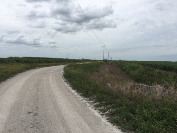
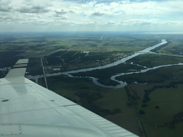
Construction site at the C-43 Reservoir, Hendry County, morning October 25, 2019
The sun’s first light rose over a gigantic crane that was displaying both the American and Florida flags. Gusts burst through the C-43 construction site as the earth slowly warmed, the giant banners flapping loudly in the wind. I smiled to myself thinking, “it really is a new day for the Caloosahatchee.”
~Confusing for those of us on the east coast, unlike the St Lucie, the Caloosahatchee sometimes needs water. The idea of the C-43 Reservoir is to both reduce the amount of water released from Lake Okeechobee that makes it to the estuary during the wet season and to store water to be released during dry season in order to help maintain an ideal salinity in the upper estuary. Right now, it is often the case that the Caloosahatchee has to “compete” with other interests for water.
With this in mind, on his second day in office, Governor DeSantis called for expediting the important long-awaited reservoir as well as adding a water quality component. People on the west coast are bold to say that DeSantis has done great things for the Caloosahatchee since day one.
Knowing I would be traveling in lands unfamiliar, I drove a day early to the C-43 site with Sean Cooley, Communications Director, South Florida Water Management District (SFWMD) and his assisting, Mr. Carter. Thus I was able to tour before and during Governor DeSantis’ visit. It was rare opportunity to learn more about Florida’s west coast.
How would I describe the expericence?
“Emense!”
Let me explain…
Video of going driving up the 45 foot mound to view the site of the C-43 Caloosahatchee Reservoir, 10-25-19.
Mr Flood points to the construction site outside of the footprint.
On Thursday, Mr Phil Flood -SFWMD West Coast Regional Representative – was the first to give me a tour. We drove a truck up a huge mound that was weighing down clay to be used in the reservoir’s surrounding dike. When we got to the top of the 45 foot hill, Mr Flood pointed in every direction: “See that tree line? See the horizon? See the edge of that old packing house? All this all will include the reservoir…”
The wind whipped by; I held my hair out of my face, eyes squinting. I thought about the once natural flow of water from Lake Okeechobee to Florida Bay. I though about how much things have changed in a hundred years.
“Just like my friend Mr Haddad told me,” I shouted across the way,” we spent a hundred years taking the water off the land and we’ll spend the next hundred years putting it back on…”
Mr Flood broke into his wonderful smile directing my eyes, again, to the horizon.
“The C-43 will be huge! The lands consists of 10, 500 square acres of former orange groves, will have 19 miles of dam embankment, 15 miles of perimeter canal, 14 major water control structures, 3 pump stations, and 3 bridges.”
“And most important, it will help save the Caloosahatchee!” I replied. We drove back down the giant mound watching the excitement as all prepared for the Governor’s arrival.
These photos in this post are from both Thursday, October 24 and Friday, October 25, 2019. They were taken as SFWMD staff along with Lane Construction Corporation, a U.S. subsidiary of Salini Impregilo prepared for the groundbreaking ceremony. The was great fanfare! We all know it’s time to fix the water!
JTL with Sean Cooley, Comm. Dir. and Carter Comm. SFWMD. 10-24-19C-43 locationWelcome!The construction site was buzzing with energy and excitementOne of many moundsView of C-43 site from the top of the 45 foot mound. Photo Phil Flood 10-24-19Looking west 10-24-19Looking east 10-24-19Looking in north with construction site below. This area will is not in reservoir’s footprint10-24-19.Executive Director Drew Bartlett speaks to Phil Flood and others. This shot is looking southerly 10-25-19.
It’s now October 25th, waiting for the Governor and First Lady to arrive!
People gather waiting for the Governor and First LadyIt’s almost time!Get ready!Is everything just right?!Look Governor!JTL, Shannon Estenoz, Ellin Goetz, Daniel Andrews
Governor DeSantis speaks!
Governor and First Lady DeSantis surrounded by guests
At the end of a long journey, SFWMD Jennifer Leeds, Interim Division Director Ecosystems Restoration & Capital Projects, and JTL stand before the future location of the EAA Reservoir’s Storm Water Treatment Area, 10-18-19.
The initial goal of my South Florida Water Management District (SFWMD) field trip was to tour Storm Water Treatment Area (STA) 3/4 and the A1 Flow Equalization Basin (FEB). When I saw the location, I asked if it would be possible to also see the A-2 lands to the west that will become the EAA Reservoir.
Later on, I realized that although the future site of the EAA Reservoir “wasn’t that far away,” it certainly wasn’t easy to get to!
After a long and bumpy truck ride atop levees and back roads we arrived. I was led by two talented South Florida Water Management staff: Ms. Jennifer Leeds, Interim Division Director of Ecosystem Restoration, and Mr. LeRoy Rodgers, Lead Invasive Species Biologist both respected experts in their fields.
After leaving SFWMD Headquarters in West Palm Beach, our first stop was STA 3/4. Tracey Piccone, Chief Consulting Engineer of Water Quality, and Nathan Ralph, STA 3/4 Site Coordinator provided an airboat tour through open areas that were once cattails. Since 2007, the cattails in the northern part of the STA are slowly dying off. This is of great concern to Tracy and Nathan as the cattails are what clean the nutrient rich water leaving the Everglades Agricultural Area. Under certain circumstances, water from Lake Okeechobee is also sent through this STA as well. Strict laws 1994 Everglades Forever Act laws require the exiting water to meet water quality standards before being sent south to Everglades National Park. The scientists spoke to me about resting, replanting, and diversifying the vegetation. I asked how we can send more water south…
It’s complicated. STAs are living systems, not machines. In fact, this 16,300 acres in western Palm Beach County is the largest constructed wetland in the world!
Tracey Piccone, Chief Consulting Engineer Water Quality, JTL, and LeRoy Rodgers Lead Invasive Species Biologist STA 3/4.Map of STA 3/4 showing where vegetation is absent and present.Nathan Ralph, STA 3/4 Site Coordinator provided an airboat tour
Airboat video:
STA 3/4
Video Mr Rodgers speaks on STA vegetation:
LeRoy Rodgers show bullrush a plant that can root in deeper watersTracy Piccone discussed water quality standardsPoster inside pump house G-370Inside pump house G-370. It was cleaner than my house!
After the tour of STA 3/4, we focused north and I could see the glistening 15,000 acres of plants and shallow waters known as the A1 FEB, a “giant triangle” always easy to locate on a map. Once the Tailsman Sugar Company, this land now functions as a Flow Equalization Basin stabilizing the waters coming in from the Everglades Agricultural Area before they go through STA 3/4.
As we drove, I tried to note the markings of multiple bird species. I was so happy to see birdlife in spite of how drastically humankind has altered this once pristine landscape. It is said that today’s wading bird population is down 90% from the days this wetland was an unobstructed “River of Grass.” As we approached, birds flew off in every direction and I thought about Marjorie Stoneman Douglas and others who forged this restoration path.
A1 FEB
After the STA 3/4 and A1 FEB tour, we drove north. Sprawling Holey Land Wildlife Management Area was on our left and the A1 FEB on our right. I asked why it was so flat and treeless. “Over the years the tree islands have washed away and been damaged,” was the reply.
We drove in silence.
Size here is Grand Canyon like and it was difficult for me to judge where we were. Suddenly, we took a sharp left. Jennifer Leeds smiled saying: “We’re here…” I climbed out of the truck.
Standing on a levee looking over both fallow and producing sugarcane fields, I stared out to the horizon. I felt my eyes tear over as it hit me that this was the land. The land that one day soon will become the EAA Reservoir.
“This was Senate President Joe Negron’s fight, this is our fight…” I thought to myself. Getting to the EAA Reservoir…
Though my husband Ed has flown me over the A2 lands multiple times, seeing them from the ground was much more convincing. If I’d had a River Warrior Flag I would have staked it in the ground. Instead, I smiled and took a picture. 🙂
Red=approximate EAA Reservoir STA; Yellow=EAA Reservoir ~ future locationFuture area of the EAA Reservoir
Video – A2 lands growing sugarcane that are to become the EAA Reservoir
Jennifer Leeds, Interim Division Director Ecosystems Restoration & Capital Projects, and JTL stand before the future area of the EAA Reservoir’s Storm Water Treatment Area. This will be the first dirt turned! 10-18-19.
Left to Right: Lt Col Todd Polk, Lt Col Jennifer Reynolds, Col. Andrew Kelly, ACOE, SFWMD lunch time, Sept 2019. Photo JTL
When I took this photo recently at a South Florida Water Management District meeting, I thought to myself “score!” It is a rare thing to see all in one place, the latest changing of the ACOE guard.
As we know, the Army Corp of Engineers, Jacksonville District, changes out its leadership top positions, almost like clock-work, every three years. I say “almost” because Lt. Col. Jennifer Reynolds stayed for four years during a time of change and controversial issues like toxic algae being discharged into the St Lucie and Caloosahatchee Rivers and the beginnings of the updating of LORS (Lake Okeechobee Regulation Schedule) to LOSOM (Lake Okeechobee System Operating Manual: https://www.saj.usace.army.mil/LOSOM/) . Acronyms aside — “how Lake Okeechobee is operated” being updated –now to possibly include considerations for cyanobacteria and human health.
Today we set our issues aside to welcome Lt. Col. Todd Polk who has now officially replaced Lt. Col. Jennifer Reynolds. (Col. Kelly has another two years.)
In case you have not met him already, as he has been being phased-in for a couple of months now, we welcome Lieutenant Colonel, US Army Deputy District Commander, South Floria, Todd F. Polk, PMP!
You can read his impressive bio below. HIs email is todd.f.polk@usace.army.mil should you like to welcome him too!
Lt. Col. Todd Polk joined the Jacksonville District as the Deputy District Commander for South Florida, U.S. Army Corps of Engineers in August 2019. He oversees the planning, construction, and operations of Corps projects in central and south Florida. Polk joins the Corps from the U.S. Army Garrison at Fort Drum, New York. While at Fort Drum he served in two positions, most recently as the Chief of Engineering and Design Branch for the Department of Public Works, and Chief of strategic and community planning for the Plans, Analysis, and Integration Office. In 2016-2017, Polk deployed in support of the U.S. Military Observation Group previously serving on the Force Headquarters Staff for the United Nations’ Stabilization Mission in the Democratic Republic of Congo. Prior to his deployment to Africa, Polk was a Project Manager for Military Construction and Sustainment and Restoration projects with the U.S. Army Corps of Engineers, Alaska District, 2015-2016. His previous assignments include the Executive Officer for the 6th Brigade Engineer Battalion (Airborne), 4th Infantry Brigade, 25th Infantry Division (A), Fort Richardson, Alaska from 2014-2015; and, Brigade Engineer and Chief of Plans, 4th Inf. Bde., 25th Inf. Div. (A), Fort Richardson, Alaska from 2013-2014.
Polk’s earlier assignments include Battalion Operations Officer, Executive Officer, and Observer-Controller/Trainer for the Sidewinder Team, Operations Group, National Training Center, Fort Irwin, California from 2010-2012. Brigade Engineer for the 3rd Infantry Brigade Combat Team (IBCT), 10th Mountain Division (Light) in Operation Enduring Freedom (OEF) 10, and A Troop Commander, 3rd Squadron, 71st Cavalry in Logar Province, Afghanistan, OEF 9-10, in 2009, Headquarters and Headquarters Troop Commander, 3rd Squadron, 71st Cavalry, 3rd IBCT, in OEF 6-7, Kunar Province from 2006-2007. G-3/5/7 Operations Officer 10th Mountain Division, Fort Drum, New York, from 2004-2005. Battalion Maintenance Officer, Headquarters and Headquarters Company Executive Officer and C Company Platoon Leader, 65th Engineer Battalion, 25th Infantry Division (L), Schofield Barracks, Hawaii from 2000-2003.
Polk was commissioned as an Engineer Officer in 1999 from the University of Kentucky. He holds a Bachelors of Arts in Communications from the University of Kentucky, Lexington, Kentucky, and a Masters of Arts in Public Administration from Webster University, Saint Louis, Missouri. His military Education includes the Engineer Officer Basic and Captains’ Career courses; Combined Arms Services and Staff School; Army Command and General Staff College; Airborne, Air Assault and Ranger courses; and, Joint Planner and Joint Fire Power courses. He is a registered Project Management Professional.
His military awards and decorations include the Bronze Star Medal with one Oak Leaf Cluster (OLC), the Meritorious Service Medal (3 OLC), the Joint Commendation Medal, the Army Commendation Medal, the Army Achievement Medal (5 OLC), Meritorious Unit Citation (1 OLC), Army Superior Unit Award, Airborne Badge, Air Assault Badge, Combat Action Badge, Ranger Tab, and the Bronze Order of the de Fleury Medal.
Polk is a native of Cincinnati, Ohio. He is married and has two children.
Thank you to Rotarians Mr Larry Lavargna and Ms Elmira Gainey for co-chairing Stuart-Sunrise Rotary’s 2nd Annual Water Forum, Public Health as it Relates to the St Lucie River. There are few instances where so many influential water voices come together to speak on the river as it relates to public health and for a question/answer period after each to boot. A excellent public forum!
I noticed that of all the speakers, Dr Gary Goforth had written out his talk, thus in case you were unable to attend, I asked if he would share. His words are included below. You can also find many of the presentations recorded and posted at Treasure Coast on Facebook.
The most powerful things happen when we all get involved and include others! Thank you Sunshine-Rotary!
We are so blessed to live in Paradise! Like you I love this river, its estuary, its mangroves, its beaches, its near-shore reefs. But as many of you know, it is a Paradise with a tragic problem. Below the surface of this serene river lies poison.
Ms. Sandra Thurlow recently provided the following treasure: In 1885, Homer Hine Stuart, Jr. for whom Stuart is named carried around a small woodcutting representing the confluence of the North Fork and South Fork of the St Lucie Rivers. This carving showed the river as 20 feet deep at the location of the future Roosevelt Bridge. Imagine that!
Thirty years later Ernie Lyons described looking down into the River 15-20 ft through clear tea-colored water to a sandy bottom below.
The area behind us was known worldwide as “Giant Tarpon Kingdom” with regular catches of silver kings above 175 pounds. The world record was reported as 220 pounds, caught just up river.
In 1913, the State of Florida decided to construct a canal connecting Lake Okeechobee with the Atlantic Ocean. The primary intent was to divert the overflow of Lake Okeechobee away from its natural course south through the Everglades, thereby allowing the sawgrass plains south of the lake to be developed for agriculture. A secondary benefit was to provide cross-Florida transportation of produce and other commerce.
On June 15, 1923, the first recorded discharges from Lake Okeechobee passed through the newly constructed St. Lucie Canal, which connected the St. Lucie Estuary to the Lake. But an unintended consequence was the discharge of countless tons of muck and dirty freshwater from the Lake that forever changed the landscape of the St Lucie River and Estuary.
Within 10 years the Martin County Commissioners had asked the State to stop the discharges “for the reason that the continued discharge of a large volume of dirty freshwater has killed all the shell fish, driven all salt water fish from the river, filled the river with hyacinths and so polluted the St Lucie River as to completely take away the attractive features and ruin its commercial value to the community.” (December 15, 1930 MCBCC)
The lake discharges drove out the king tarpons – the 150-200 pounders – and the small city of Stuart recast itself as the “Sailfish Capital of the World.”
Ernie Lyons described the damage in this way:
“We turned our good, sweet water into a cup of poison and changed a laughing little river into a reeking abomination – in the latter part of an ordinary lifetime. Clean rivers are not “forever and forever” like the sunrise.” (from The Last Cracker Barrel (1976) p 62)
As a professional engineer I’ve had the honor of working to protect the environment of south Florida for more than three decades – in the Everglades, in Lake Okeechobee, along the Kissimmee River and its headwaters, and in the magnificent estuaries –the St Lucie and Caloosahatchee. My wife and I raised three kids here along the St Lucie River and I’ve taught my two grandsons to fish and appreciate the incredible biological diversity throughout the river and estuary and near shore reefs. But unfortunately, we don’t eat the fish we catch in the River because of the public health risk.
I recently had the misfortune of being in the emergency room of our local hospital. One of the very first questions I was asked was if I had had any recent contact with the St Lucie River.
During the 2016 discharges I walked along Stuart Beach with Jacqui Thurlow-Lippisch and we collected the names and stories of over 100 people who had gotten sick after coming in contact with the water.
A beautiful dog, Finn, died that summer after morning frolic in the water. Several other dogs suffered acute liver failure, and suffer to this day.
2016 was a watershed year in understanding the relationship between the discharge of polluted water from the Lake and public health. The media began to focus on toxic blue green algae – particularly the microcystis form. While parts of our beloved estuary were covered in foul smelling neon green guacamole, the media began reporting on the effects of microcystis and human health. An Ohio State University study reported that those of us in Martin and St Lucie County have twice the national average rate of death for non-alcoholic liver disease. They correlated this high rate with one thing – discharge of polluted water carrying blue green algae from Lake Okeechobee. This particular form of blue-green algae – microcystis – carries a dangerous toxin that can cause serious liver disease which can lead to death. Additional human health risks have also been identified – Parkinson’s, Alzheimer’s and Lou Gehrig’s disease.
In the last year – thanks to the efforts of Congressman Brian Mast – the Corps of Engineers acknowledged for the first time that Lake discharges to the estuaries carrying microcystis are toxic to humans, and the US Government makes these discharges knowingly and with the understanding that they are poisoning us – the public that they serve.
Numerous public health advisories have been issued in our region in association with lake discharges – warnings to the public to avoid contact with the water. But none have ever been issued when Lake water is sent south – the environmental conditions south of the lake are not advantageous for sustaining toxic blooms. So the alternative to knowingly poisoning the public are clear – send the water south.
Col. Kelly is now in charge, and we are truly grateful for his leadership. As the Corps revises its operation schedule of the Lake, I am sure that Col. Kelly will ensure that the public health, economies and environment of our region are given equal weight as the public health, economies and environment of the area south of the Lake. Hundreds of millions of dollars in economic loss are felt by the regions around the estuaries during years of heavy lake discharges. Public health is adversely affected. There is no acceptable level of lake discharges. There is no level of Lake releases to the St Lucie Estuary that is beneficial.
Lake discharges contain pollutants include toxic blue green algae, sediment (muck), low salinity water, and nutrients. However, even if all the Lake water was sent south, our beloved St Lucie would still be in trouble. Our local watershed has its challenges – particularly high levels of nitrogen and phosphorus in agricultural runoff. Our watershed suffers from the same lack of pollution regulation as the Lake Okeechobee watershed: landowners are not held accountable for pollution from their property.
But the problem is not just ag runoff – WE ALL ARE RESPONSIBLE. For the St Lucie Estuary, approximately 5-10% of the total nitrogen loading is from our septic tanks. If you have a tank – have it inspected and maintained. Water quality data show an improvement in nitrogen levels due to positive actions taken by the City of Stuart, Martin County, Port St. Lucie and homeowners – conversion of more than 8,000 septic tanks to centralized sewer. The City of Stuart has one of the best programs for converting septic tanks to sewers: a voluntary system that allows homeowners the option of waiting until their tanks or drainfields need replacing before hooking up. But converting septic to sewer doesn’t solve the problem of nutrient overload – it just moves the problem to other areas. The majority of the residuals from wastewater treatment plants are returned to our watersheds as “biosolids” that contain high concentrations of phosphorus and nitrogen. An article in this morning’s Stuart News documented the presence of antibiotic-resistant bacteria in dolphins, and the researchers attribute much of the problem to pharmaceuticals that pass generally untreated through centralized sewers and are returned to the watershed through biosolids. We still need a better strategy for managing biosolids. Sen. Harrell – we look to you for leadership in the Legislature to require additional oversight and regulation of the application of all biosolids in our watershed.
The Florida Legislature is the single most influential group that can positively affect the public health in the state of Florida. The Legislature has an obligation to understand that allowing continued pollution of Lake Okeechobee and the estuaries will directly and adversely impact the health of the public you represent. Unless the State begins holding landowners accountable for the pollution they generate, there is absolutely no reason to believe that our water quality will improve and as a result, our public health will continue to decline. No matter if the Corps and SFWMD implement all the projects on the books – there will still be Lake discharges of toxic water to our estuaries – and unless the Legislature reverses its direction, the water quality and public health problems will persist.
I ask Sen. Harrell to work with the Legislature to hold the state’s Dept. of Environmental Protection (DEP) accountable for protecting our environment. Their current program for improving water quality going into the Lake is terribly broken. Pollution loading to the lake reached an all-time high in 2017. And compounding this problem is that annual DEP reports to the Governor and legislature and public are misleading – as they allege that pollution loads are decreasing – when the reality – as documented by the SFWMD – is that average pollution loads are higher than the Starting Period. For 2017 the measured phosphorus loads to the Lake were 60% greater than they reported in their annual report. For 2018, the measured loads were 40% greater than they reported. Who holds the DEP accountable for transparency and accuracy in reporting to the Governor, the Legislature and the public? Sen. Harrell – please demand accountability on the part of DEP.
USEPA recently established draft guidelines for microcystin in water. We urge the legislature to direct DEP to expeditiously embrace and adopt those guidelines to protect human health. We support Col. Kelly’s efforts to prevent Lake discharges to our estuary that contain blue green algae, and urge him to adopt the microcystin guideline into the new version of the Lake operating manual.
I want to thank Ms. Thurlow-Lippisch on behalf of the SFWMD – for exploring more ways to sending Lake water south through the STAs, into the Everglades and on to Florida Bay. The SFWMD is also the agency responsible for collecting water quality data documenting the state of the water. Thanks to the leadership of Ms. Thurlow-Lippisch, they are initiating steps to establish a regulatory program that if done properly will hold landowners accountable for reducing nutrient pollution. The SFWMD will need our support as they develop an effective program – and we the public need to turn out and support them in their efforts.
We’ve heard Col. Kelly and others describe projects to be completed in the next 2-3 years. Wouldn’t it be wonderful to celebrate the 100th anniversary of the first discharges from the Lake with a promise to stop the toxic discharges?!
I’d like to end with a challenge for all of us from an idol of mine – Timer Powers – Timer was a former Martin County commissioner and water management board member and Executive Director:
“The greatest challenge in front of us is to take the steps that are necessary to assure that our younger generation has the rivers, the creeks and the critters that are at the heart of our whole society. There’s not many people representing the critters, and if we fail to represent those who can’t represent themselves, either nature or people, then we have failed.”
So to my fellow clean water advocates – let’s rise up to meet this challenge! We can do this people!
Thank you all, and to the Rotary for bringing us all together on this beautiful day along side this beautiful estuary!
This weekend I had the honor of being asked by the Citrus County Historical Society to speak on the final day of the county’s “Save Our Waters Week.” The theme “Make a Difference!” Citrus County houses multiple springs, three holding the title of “first magnitude.” These once “pellucid” waters form Crystal River and then flow out to the the Gulf of Mexico.
Although my most recent title is Governing Board, SFWMD, I was clear to say the presentation was my own words and that I have been acting and speaking out as a water advocate for eleven years.
Although I cannot share my words, I think it is important to share my presentation. See if you can add the words yourself…What do Florida’s Springs and the Everglades’ Northern Estuaries have in common? How can we work together to be an even more powerful political force?
Thank you to Florida nature photographer, John Moran, for sharing his aerial photographs of the Crystal River region and for his documentation of the deterioration of Florida Springs. As with the St Lucie River, we must look below the surface to see what is really going on…and we must speak out to stop it!
Ed flying Billy Vaughn, Vice-President, and Tara Baldwin, President, Operation 300. The organization is in honor of son and brother Aaron Vaughn http://op300.org
Rarely have I seen my husband with such determination, and he’s very determined all of the time…
The goal?
To get his multi-generational Bahamian friend, fishing guide, Justin Sands of Marsh Harbor, a cooler of 16 hamburgers, some buns, mustard and ketchup, and a bag of tomatoes…
Ed told me he would be flying into Treasure Cay dropping off the Vaughns, president and vice-president of Operation 300, the group in Stuart, Florida, that is doing great things for the relief effort. Ed would be greeted by Stephen Leighton who along with his brother, John, are masterminding Operation 300’s coordination. Ed had hoped to get a ride to Marsh Harbor from Treasure Cay to meet Justin, about 26 miles away. That did not happen.
“Why didn’t it happen?” I asked Ed when he got home.
“Jacqui, there’s nothing left there. The beat-up cars they have, have no gas….or very little. The car they were lucky enough to have, ran out of gas.”
So after dropping off the Vaughns and not being able to get a ride, Ed asked Steve Leighton if in the course of his work, could he please deliver the hamburgers. Ed flew back to Stuart, and then something happened that could only happen today.
With Ed now back in Florida, and Steve and Justin with very limited communication service —Stephen in Treasure Cay, and Justin in Marsh Harbor—-the three, via text messaging, and an app called WHATSAPP, coordinated the 16 hamburger drop-off.
Stephen then sent Ed a picture of Justin and he standing amidst Marsh’s destruction- red cooler in tow. Delivery achieved! Later that evening Justin sent Ed a picture of the prepared hamburgers.
When Ed shared the photos, my eyes filled with tears…
Friendship and determination are something that Dorian cannot destroy.
Justin Sands and Stephen Leighton, Marsh Harbor Sept 18, 2019.
Other photos shared by Stephen Leighton, Operation 300, 9-18-19
Before Hurricane Dorian came this way, my brother, Todd, was helping me answer a question. ~One I think will be interesting to you as well…
“Where were the rapids of Lake Worth Creek?” Yes, rapids!
T41S R43E, Survey 1855 John Westcott, Surveyor General.
To answer the question, we must first recognize that Lake Worth Creek has been altered as we can see comparing the images above and below.
This change happened slowly over time, but most notably in 1894 with the completion of the Intracoastal Waterway from Jacksonville to Maimi. The Google Map below shows the Intracoastal today. The 1855 survey above shows Lake Worth Creek pre-development. In both images, it’s the area between Jupiter Inlet and Lake Worth- the historic area of Lake Worth Creek.
To learn where these rapids were located let’s read an excerpt from Palm Beach County’s MANAGEMENT PLAN FOR FRENCHMAN’S FOREST NATURAL AREA, FCT PROJECT # 96-011-P7A, June 1998.
The Frenchman’s Forest Natural Area (located right under Frechman’s Passage, JTL) is part of a broad coastal swale that was separated from the Atlantic Ocean by coastal sand ridges and from the Loxahatchee Slough by a broad pine flatwood ridge. It was part of the headwaters of the former Lake Worth Creek, a meandering blackwater creek that flowed northward to join the Loxahatchee River near its mouth at the Jupiter Inlet. The earliest accounts of the site date from the 1840s, and were from U.S. Army Topological Engineer reports made during the Second Seminole Indian War (Corbett 1993). Eighty men from Fort Jupiter moved up Lake Worth Creek in seventeen canoes. Approximately two miles north of the natural area, they reached the “rapids”, a series of muck terraces that disappeared during periods of high water, but helped hold water at a higher level in the upstream sawgrass marshes. Another series of muck terraces may have been present 0.25 miles north of the natural area. After getting past these barriers, the troops entered a large sawgrass marsh, where they pulled the canoes for a mile to a haulover path over the sand ridge separating the marsh from Lake Worth. The southeastern portion of the natural area was part of the sawgrass marsh, and the soldiers may have crossed through the site. Once they reached Lake Worth, the soldiers raided Seminole Indian villages along its shores, capturing guns and canoes. The soldiers had followed an old Indian route for traveling between Jupiter Inlet and Lake Worth. When the last Seminole Indian war ended in 1859, pioneers began to use this route for coastal travel. Charles Pierce (1970) described his family’s travel to Lake Worth by small boat via this route in 1873. He noted his father’s difficulty in finding the right channel through the sawgrass to the haulover. Pierce and his family were among the earliest permanent settlers on the shores of Lake Worth. Pierce also provided the first direct reference to the natural area, noting that the bird rookery on Pelican Island (present-day Munyon)…
Another source we can use comes from the Atlantic and Gulf Coast Canal and Okeechobee Land Company 1881 Prospectus where it documents the advantage of making the cut through Lake Worth Creek. Nine lines from the bottom it mentions the rapids: “There is a depth of five feet of water in the channel from its mouth to the rapids…”
And the last shared source is from an 1884 USGS Survey Report noting the difficulty of working through the sawgrass route from Haulover Head on Lake Worth to the Rapids of Lake Worth Creek.
Fascinating and historic information, but what about X marks the spot? Where were those rapids?
Using the above information, below (look for yellow arrow) Todd shows more specifically on a topo map from his video “Lake Worth through the Haulover and Sawgrass Route to Jupiter Inlet – 1883” showing where Lake Worth Creek’s rapids may have been located. On today’s map that is very close to Frenchman’s Passage/Frenchman’s Creek.
Next time you’re in the area give a shout out to the once rapids of the former Lake Worth Creek, a wonder of old Florida that we shouldn’t forget!
9:16am 9-16-19: I was close! My brother just texted me this: Hey Jacqui. Sorry Dorian interrupted our discussion of the Falls. It was actually near the creek called Frenchman’s Creek on the old topos not Frenchman’s Passage which is a neighborhood today about a mile and a half south and inland from the old creek/rapids. 😬
Frenchmans Creek still appears on Google maps. It is where Cypress Island Marina is today off of Palmwood Road.
Today I got a call from my husband’s good friend, dentist and pilot, Scott Kuhns.
“I’m going up in the Super Cub” he said, “what pictures do we want?”
“Great!” I replied. “How about the canals? -what’s killing the river at this time. C-23 and C-24, nearer to St Lucie County, and C-44 in South Stuart-even though the ACOE isn’t dumping from Lake Okeechobee right now?”
I was thinking to myself that it’s important to see how these area canals affect our waters even without the worst off all, -discharges from Lake Okeechobee! Between all the extra water, Mark Perry says that the St Lucie River takes on more than twice it did from its natural watershed.
Scott’s voice came over the phone…
“How about the coast?” Scott inquired.
“Absolutely. The coast. There should be a pretty decent plume just from the canals and local runoff.”
“‘llI be in touch,” Scott said, and he was off!
Well, I just received Scott’s photos about an hour ago. The photos are telling and Dorian’s plume is very, very dark.
Dorian, all I can say right now, is thank you for not striking Florida. It was a scary few days, so close! And God bless the people of the Bahamas…
PHOTO BY SCOTT KUHNS and PILOT STEVE SCHIMMING, 9-6-19 at
SFWMD, Treasure Coast canals-Stuart north to St Lucie/ Indian River County.
ROOSEVELT BRIDGE, WIDE AREA OF SLR, HABOARAGE MARINA, STUART
C-23 & C-24 CANALS, C-23 DIVIDES MARTIN & ST LUCIE COUNTY, C-24 in ST LUCIE CO.
C-44 CANAL, SOUTH STUART
ATLANTIC OCEAN OFF HUTCHINSON ISLAND~PLUME VIA “LOCAL RUNOFF” & CANALS C-23, C-24 & C-44 (LAKE OKEECHOBEE IS NOT OPEN AT THIS TIME)
ST LUCIE INLET & SAILFISH POINT
AREA BETWEEN SEWALL’S POINT AND SAILFISH POINT KNOWN AS THE SAILFISH FLATS WHERE SEAGRASS HAD BEEN GROWING BACK.
Background: Time Capsule Flight: Jupiter to Lake Worth Haulover Canal, by Todd Thurlow
Recently, my husband Ed and I guided Adrift south from Stuart to the Lake Worth Lagoon. For us, the boat ride was delightful! Jupiter is by far one of the Intracoastal’s most beautiful of places with its blue water and iconic Jupiter Lighthouse. Today the canal linking it to Lake Worth Lagoon is easy to navigate. What we must remember, as the video above shows, it wasn’t always this way…
Today I share Ed and my 2019 modern Intracoastal Waterway photos contrasted to an 1884 account by Champlin H. Spencer, an experienced seaman, who took the same route in 1884 before the area was developed. In his account, he describes this journey as “the most arduous of any yet experienced.” In the early days, this area between Jupiter and Lake Worth was a marsh, creek and in high waters, a sawgrass highway. It must have been spectacular in natural beauty, but not so easy to navigate!
Thank you to my mother, historian Sandra Henderson Thurlow for sharing this rare piece she researched from the National Archives while writing her book US Life-Saving Service: Florida’s East Coast.
The Jupiter Lighthouse, 1860, Jupiter Florida, 2019 photo JTL.
~From the library of historian Sandra Henderson Thurlow, a historic account: Jupiter to Lake Worth, 1884.
A letter in the national archives written to Captain James H. Merryman, Inspector of Life-Saving Station by Champlin H. Spencer. Spencer became the superintendent of District Seven after William Hunt died in 1882. The narrative illustrates the hardships encountered by early District Superintendents.
Nov. 6th, 1884
Port Orange,
Sir,
In connection with my last trip, I may say, it was the most arduous of any yet experienced. Knowing the October trip to be the worst of the year, I had provided the government sharpie with new sails at my own expense… the only practicable means of locomotion for the Superintendent to get over the 7th District. On arriving at Jupiter, a gale was blowing, a hurricane expected and no reasonable prospect for weeks for crossing the various bars on my route.I therefore borrowed a boat from the assistant light-house keeper Carlisle, pushed in company with my boat-hand through the everglades to haul-over near Lake Worth with the little dinkey in tow which with my boat-hand’s help, it being a desolate point, I tugged over to Lake Worth. The experience of making miles a few inches at a push with pole adhering in the mud & all locomotion confined to literal pushing through lily-pads & rushes cradled in amphibious land is unique while on this occasion camping in an open boat in a torrent of rain amid such surroundings gave a higher spice to its uniqueness. My regular boat-hand returned to Jupiter to take care of (?) while in the cockle shell of a dinkey, proceeded to the settlement, procured a sailboat, hoisted the peak as reef, sailed down the lake & hence footed it down the beach. Mr. Quimby … more from innate gallantry & personal liking than for pay, accompanied me and at the Hillsborough swam the gauntlet of alligators and shark to the other side, bring from the opposite side the boat left there by the Coast-Survey although in so doing he came nigh being swept out to sea. The water was very high, the walking, at all times execrable, was the worst I have ever known it along the coast so that on arriving at Lauderdale station, it being impossible at the time to push through the everglades in a boat to Miami the gale still blowing, I dispatched Keeper Peacock for Keeper Pierce who met me a Lauderdale and there signed the pay-roll. It is my settled purpose not to shirk any portion of the route, but footsore, exhausted and down with a chill & the back track before me, the volunteered readiness of Keepers Peacock & Pierce to meeting me at Lauderdale was truly acceptable & I trust inspection in the premises will not meet with severe censure.*Photocopy of official letter obtained from Ranger Sandra Hines, Canaveral National Seashore.
Old Dixie Highway and rail road bridge, Loxahatchee River, Jupiter, FL.Loxahatchee River headed towards the canal that takes one to Lake Worth Lagoon, formerly Lake Worth.Donald Ross Bridge, Intracoastal.
Google Earth map shows modern Jupiter Inlet, Loxahatchee River and canal known as the Intracoastal Waterway that makes navigation to Lake Worth easy. This stretch was formerly sawgrass, a marsh and creek. (Lake Worth Creek)
Parker Bridge, US1, Intracoastal. This is the last bridge before entering north Lake Worth Lagoon and may have been close to the original “Haulover.”Intracoastal opening into northern Lake Worth LagoonNow entering the mouth of northern Lake Worth (Lagoon. The Haulover canal was right in this area.Northern Lake Worth LagoonLake Worth Lagoon now a mixtue of salt and fresh water, was formerly fresh.
Last week, I told my mother that my husband Ed and I were planning on taking the trawler from Stuart to Fort Lauderdale down the Intracoastal Waterway, and that I was most excited about passing through the Lake Worth Lagoon: https://www.floridamuseum.ufl.edu/southflorida/regions/lake-worth-lagoon/
“Do you have some history for me?” I asked.
She ran upstairs returning with a little booklet entitled “Under the Cocoanuts, Lake Worth, Dade County, Florida, by Porter and Potter, Real Estate Agents, 1893.” Mom said her friend and fellow historian, Mrs. Marjorie Watts Nelson, had gifted a copy of the famous little book and that it was cherished.
I carefully looked through it and understood why…
Today, I would like to share this historic booklet. I believe pages 15 and 19 are missing, but it remains a priceless read. The beautiful artwork was created by George Wells Potter, of Porter and Potter, a star citizen and gifted artist whose drawings remain an outstanding record of the day.
My recent post about “Holding Lake Okeechobee’s Algae at Bay” got a lot of responses with a few questioning whether the algae bloom in Lake O off Port Mayaca was caused by the waters of C-44 flowing back into the lake.
I do not know the answer to this question, but I do know flights over the C-44 canal in 2019 have shown no visible algae blooms, but many in the lake with some right off Port Mayaca. Nonetheless, we know the C-44 is full of nutrient pollution.
Today I want to share a chart from my brother Todd Thurlow’s website http://eyeonlakeo.com/ as well as our back and forth on the issue of how much water has been put into Lake Okeechobee from C-44 so far this year rather than going into the St Lucie River. The ACOE can flow C-44 flow both ways…
Be sure to read “Summary of Query Results” below for the answer.
Todd: Jacqui, I changed my DBKey on my daily spreadsheet to S-308 just to see what it would spit out. See below. It looks like S-308 has sent a net 17billion gallons of C-44 basin water (over 54,000 AF) into Lake O this year. I am pretty sure that means we get a “free” 17billion gallons in our direction before it is considered “Lake Water”.
Jacqui: Todd did the ACOE start sending the C-44 canal water back to Lake O May 29th? Looking at the chart this is what I see.
Todd: There has been little flows all year as can be seen on the chart too but the big flows started on May 13 at -2042cfs. There was a pause between June 4 and July 30. Then is started again with a few days off here and there. Here is the data that is summarized in that chart.
The May 29 date that you might see (its actually May 20) is where the “Cumulative Total Discharge” graph crosses the zero axis? That is where the net flows for the year were back to zero. In other words, it took from May 13 to May 20, 8 days of westward flow, to cancel out all of the net eastward flow for the year.
SFWMD canal and basin map. C-44 can run east to the St. Lucie or west to Lake Okeechobee.
These DEP canal summaries are no longer available on-line but remain good references even though written in 2001.
My husband, Ed, was able to fly the Baron yesterday. As the plane has been in service, we have not taken photos of Lake Okeechobee or the St Lucie River from a higher altitude in almost two months.
Because the satellite images have been showing Lake Okeechobee’s bloom lessening, I wasn’t sure what Ed would find. Well, he found a large blue-green algae bloom right outside the gates of Port Mayaca at S-308.
On his way back to Stuart, he also took pictures of the St Lucie Inlet showing plentiful seagrass recovery near the Sandbar at the confluence of the St Lucie River/Indian River Lagoon, the ocean/river looking blue and inviting ~ not like the black coffee sediment and toxic nutrient-filled discharges seen recently in 2013, 2014, 2016, 2017, and 2018.
I am thankful to the ACOE and all involved for this summer’s reprieve. The Saint Lucie River really needed it!
We must keep in mind that with all of the recent rain, of course, Lake Okeechobee is rising. Today lake is at 12.99 feet. Hopefully, in the coming and most active months of hurricane season, there will not be a tropical system that could rapidly increase the lake level. In years past hurricanes have brought as much as three or four feet. There are many factors, but usually, the ACOE starts releasing at 15.5 feet to protect the Herbert Hoover Dike’s integrity and those living south and in the shadow of our diked lake.
Humans may have figured out how to “control” the state’s water, but Mother Nature holds the final card.
SFWMD 8-19-19
LAKE OKEECHOBEE AT PORT MAYACA AND LAKE O’S N.E. RIM SHOWING ALAGE BLOOM. IF S-308 were open, this bloom and freshwater that sustains blooms would be pouring into the St Lucie River/Indian River Lagoon. Photos by Ed Lippisch 3-18-19.
Lake O
N.E. Lake Okeechobee and Rim Canal
Boat tracks through algae bloom off Port Mayaca
Looking toward Lake Okeechobee at S-80, A.K.A. “The Seven Gates of Hell.” These gates can be opened by the ACOEO to discharge water from Lake O into the St Lucie River. Photo Ed Lippisch 8-18-19.
C-44 Canal connects Lake Okeechobee to St Lucie River, photo Ed Lippisch 8-18-19
ST LUCIE RIVER/INDIAN RIVER LAGOON AT ST. LUCIE INLET showing nearshore reefs, blue waters, and recovering seagrasses ~even with high local rains and discharges from canals C-23, and C-24. This area between Sewall’s Point and Sailfish Point was once considered the most bio-diverse in North America. This year, 2019, there have been no discharges from Lake Okeechobee allowing the area to begin to recover from years of destructive discharges from Lake Okeechobee.
St Lucie Inlet at the confluence of SLR/IRL, #Clean2019
Darker shades are recovering seagrasses!
Flight Aware Track:
SFWMD canal and basin map. C-44 canal is the canal most southerly in the image and connected to Lake Okeechobee.
Phy·to·ge·og·ra·phy: the branch of botany that deals with the geographical distribution of plants.
Historic Phytogeography of South Florida with Present Day SFWMD Features, 2019, by Lexie Hoffart & Nichole Miller, Geographers, SFMWD.
It started with a request, an idea, and over many months materialized with the guidance of Tia Barnett, Governing Board and Executive Services, and Dr. Ken Chen, Supervisor, Geospatial Mapping Services Unit, Information Technology Bureau, SFMWD.
The request: “Could we create an educational map blending pre-drainage natural features such as water flow, plants, and forests with the modern sixteen county map we use for today’s SFWMD’s “Facilities and Infrastructure”?
Dr. Chen excitedly assigned two young modern-day cartographers/geographers to the task: Ms. Lexie Hoffart and Ms. Nicole Miller.
Their research began with an overlay of the famous 1913 Phytogeographic Mapof the Original Florida Everglades by John Harshberger. Then they “moved north” to research the Kissimmee River and Lake Okeechobee using the 1882 Communications Steamboat Map by W.G. Williamson and Q.A. Gilmore of the USACE.
Modern publications were studied as well: a 2017 article by Michael A. Volk, UF, entitled “Florida Land Use and Land Cover Changes in the Past 100 Years:” alsoLandscapes and Hydrology of the Predrainage Everglades, 2011 by Christopher W. McVoy. All this and more was taken into account as an overlay on a modern SFWMD map of present-day facilities and infrastructure including modern estimates of populations.
Wow! What does the old adage say? “The only constant is change!” May understanding the past help us to be better stewards of the future…
The outcome, a document rich in revelation past and present. Thank you, Lexie and Nichole!
Historic Phytogeography of South Florida with Present Day SFWMD Features Map, Lexie Hoffart & Nicole Miller, SFWMD 2019Lexie Hoffart, JTL, and Nicole Miller at SFWMD where they were recognized yesterday for their work!
The Crossroads off Sewall’s Point in the confluence of the St Lucie River and Indian River Lagoon. In 2019, seagrasses can be seen returning to an area that was post-2013, 2016, and 2018 a desert of sand. 8-3-19 photos by Scott Kuhns.
On August 3rd, I posted the above aerial noting the return of visible recovering seagrasses since the ACOE stopped discharging from Lake Okeechobee.
One of my readers wrote: “Most is not true seagrass, some algae’s, discolored sand. A little shoal grass here and there. It’s gonna take a few years of no discharges.”
And this is true. Seagrass is growing back, but right alongside, or even on the algae itself, is something else. A type of dark green, slimy-algae covering the grasses. I don’t remember it like this before…
We are living in a time of over-nitrification. Too much Phosphorus and Nitrogen drains off the land into the estuary feeding algae of all kinds as they compete for dominance.
And we decide who wins:
~A great video shared by my brother Todd covering the story of all types of algae and cyanobacteria.
8-3-19 Scott Kuhns what do you see?8-3-19 Scott Kuhns looks back towards Stuart from St Lucie Inlet area. Area to right was once famous for its rich seagrass beds.
I have seen the microalgae growing back on our seagrasses in the SLR/IRL, and it has been here for years; it is just getting more dominant. I have not photographed as doing so requires a protected camera. Thus I am sharing these photos that in some ways resemble our beds.
Today, Ed and I document a summer day along the St Lucie River/Indian River Lagoon without Lake Okeechobee discharges. ACOE, we are grateful! J&E
The Crossroads between Sewall’s Point and Sailfish Point, the confluence of the St Lucie River/Indian River Lagoon. Seagrasses returning…Hutchinson Island south of the St Lucie Inlet, home of the northern reefs. Color- blue not brown!The St Lucie Inlet looking beautiful.Sailfish Point at the St. Lucie Inlet, blue and turquoise meet.Sailfish Point along the ocean with Sailfish Flats and Sewall’s Point in background.Sailfish Flats east of Hutchinson Island and the Atlantic Ocean. Ed and I could not fly over IRL here due to air traffic, so I could not get up close pictures. But the color certainly looks better!Turquoise ocean but lots of sargassum weed! Turtles and manatees were present.Just north of Martin County, St Lucie County’s Hutchinson Island beaches with super density Nettles Island visible in a blue looking Indian River Lagoon.Hutchinson Island and IRL in St Lucie CountyIndian River Lagoon with good visibility as discharge water is not being pushed up north through the IRL in Martin County.IRL St Lucie County, good visibility and some seagrasses.IRL St Lucie County looking to the Savannas.A clearer IRL due to lack of discharges from Lake O. The most suspended sediment comes into the SLR/IRL from Lake O. St Lucie County. As I said earlier the tower would not allow Ed and I to fly over the S. IRL in Martin County due to air traffic. We will have to get it another time.IRL near St Lucie Power PlantNettles IslandBack south, looking over Indian Riverside Park and the Penninsula of Sewall’s Point. IRL on left. St Lucie River on right. St Lucie Inlet and the Atlantic Ocean in distance.St Lucie River, Langford Landings docks, with Roosevelt Bridge and Stuart in distance.
St Lucie River, west side of Sewall’s PointWide St Lucie, Roosevelt Bridge, Rio, and Stuart.Wide St Lucie looking west towards Lake Okeechobee.Ed and Jacqui -seven years older since the first “lost summer” of photographing in 2013 ~never giving up!The Super Cub!
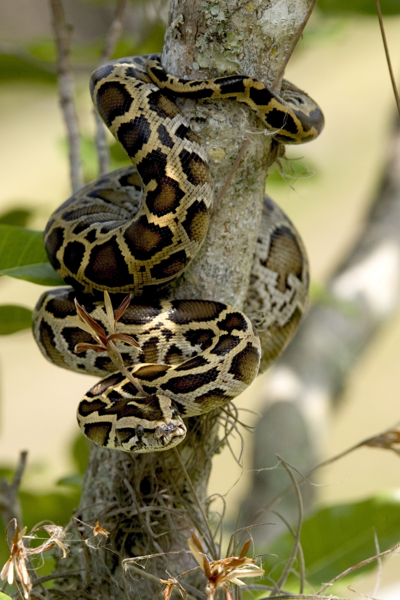
Skilled hunters, Burmese Pythons are one of the five largest species of snakes in the world and native to South and Southeast Asia. They are a threatened species in their native lands, but today there are breeding populations in a new environment, the Florida Everglades. Image public domain.
I have this dream that I am enjoying walking around in my garden, I look down, and there is a seventeen-foot python curled up under my house. Sounds ridiculous, but one day this may not be that far fetched.
This past week, the Florida Wildlife Commission (FWC) https://myfwc.com held their meeting at the Hutchinson Island Marriott, just over the Ernest Lyons Bridge from Sewall’s Point. One of the things they discussed was the overpopulation of Burmese Pythons that are ravaging native wildlife in Everglades National Park and other parts of South Florida.
I have been vaguely aware of this for years. My previous Sewall’s Point neighbor was a python enthusiast. Around 2012, he wrote TCPalm a letter to the editor in the python’s defense arguing that the Burmese Python did not bring itself to South Florida, people did! According to FWC pet pythons have been released since the 1960s but it was after Hurricane Andrew’s 1992 destruction that a breeding facility was destroyed, pythons escaped, the population exploded, and a breeding community arose.
I do believe “in all God’s Creatures,” but this is a nightmare-dynamic for Florida’s native wildlife. Public speakers noted Everglades National Park is “devoid of small mammals.” This is not an exaggeration, perhaps down 98%, and “small mammals” are not just what’s for dinner. Meals also include birds, eggs, bobcats, deer, alligators and who knows what else. Mr. Kipp Frohlich of FWC estimates a range from tens-of-thousands to over three-hundred-thousand snakes could be living in the Everglades. We really don’t know. One was even found in Florida Bay all curled up on a buoy. Oh yes, they can swim.
If I were a python and my friends and I had eaten everything down south, what would I do? I’d slither north…
Opossums, armadillos, and families of raccoons visit my yard a few times a week. ~For now…
python-snake, public image
Please see links to learn about what is being done to controll and educate ourselves on the python:
FWC Presentation
Division: Habitat and Species Conservation
Authors: Sarah Funck, Kristen Sommers, and Melissa Miller, Ph.D. Report date: July 2019
*Florida still allows breeders of Burmese Pythons in Florida, but they can only sell the animals outside of the state. All things considered, at the meeting, FWC Commissioner Gary Lester questioning the wisdom in this. I agree. Considering this is how pythons got out of control in the first place.
The Florida Channel videos of FWC meetings in Hutchinson Island; pythons: day 2:
As I wrote about yesterday, Governor DeSantis’ Executive Order 19-12 calls for the Basin Management Action Plans around Lake Okeechobee to be “updated” by January 10, 2020.
Dr Goforth (http://www.garygoforth.net/Other%20projects.htm ) is a familiar and trusted friend in our fight to protect the St Lucie River/Indian River Lagoon. Today, I am sharing his comments made during the development of the Basin Management Action Plan for the St Lucie River; and also his easy to read charts presented at the June 10, 2019, SFWMD Northern Estuary Workshop. It is my hope, that my very oversimplified post from yesterday can be complemented by Dr. Goforth’s input.
From Dr. Gary Goforth, Ph.D
Subject: Estuary Water Quality Protection, July 8, 2019
Looking forward to a productive workshop on Wednesday…
2. Subject: RE: Estuary Water Quality Protection, July 12, 2019
Thank you for a very productive workshop Wednesday on water quality and its impacts to the northern estuaries.
I’ve been asked for copies of the documents I held up during my public comments. These were developed pursuant to the 2007 Northern Everglades and Estuary Protection Program (NEEPP), and were to serve as the technical foundation for an expanded Works of the District (Rule 40E-61) regulatory program administered by the SFWMD. These documents summarize the most comprehensive analyses of water quality and hydrology for the Lake Okeechobee and estuary watersheds. These were presented to DEP during the development of the BMAPs – but DEP chose not to take advantage of them. Even worse, prior SFWMD management worked with an agricultural lobbyist to remove all references to these documents from the 2015 SFWMD annual environmental report (“In 2014, South Florida water managers were on the verge of an agriculture pollution crackdown, but at the last minute reversed course. TCPalm obtained emails that show how a lobbyist influenced water policy. The South Florida Water Management District changed course immediately after a Dec. 3, 2014, meeting with U.S. Sugar Corp. lobbyist Irene Quincey, eventually halting its planned policy in favor of a plan that takes polluters at their word and holds no one accountable if water quality suffers.” http://www.tcpalm.com/story/news/investigations/2017/08/30/u-s-sugar-lobbyist-influence-over-florida-water-pollution-rules/464671001/).
They can be downloaded from the following links; I’m sure staff could provide hardcopies (they’re several hundred pages in length).
Executive Order 19-12 “What can we do to achieve more now for Florida’s Environment?”
Sometimes all the bureaucracy of water management makes it difficult to understand how things work. Today, I am going to summarize the goals and requirements of Governor DeSantis’ Executive Order 19-12 Section 1, C. in hopes of giving some simple insight into the responsibility of our state agencies to publicly come together to achieve the Governor’s goal; there are only six months remaining.
On January 10th, 2019, just days after being sworn into office, Governor DeSantis put forth Executive Order 19-12. This order has multiple components, but today, we will focus on Section 1, C:
It states: “Update and secure all restoration plans, within one year, for waterbodies impacting Soth Florida communities, including Lake Okeechobee, the Caloosahatchee, and the St Lucie Estuaries. These updates will ensure the Blue-Green Algae Task Force has the necessary information to provide guidance to the Department of Environmental Protection on maximizing the investments in water quality improvements.
This means that the Basin Management Actions Plans, the system the state uses to try to improve water quality through lessening phosphorus and or nitrogen runoff have to be “updated” by January 10, 2020.
Prior to the Governor’s Executive Order 19-12, there was no unified update date, nor a clear deadline date. Why? Because state statute doesn’t give one. How come? Because over the years special interest has lobbied our state legislature to make it this way. Governor DeSantis’ order complicates this by giving a hard deadline to find out how these BMAPS are working or not working.
An update is an “update on the status of implementation at the end of the first phase and an opportunity to provide recommendations for future phases of the BMAP.”
The three Basin Management Actions Plans that need to be updated include the Okeechobee BMAP; the St Lucie BMAP and the Caloosahatchee BMAP.
The agencies that oversee this process are the Department of Environmental Protection (regulation of water quality standards); the Dept of Agriculture and Consumer Services (BMPs or Best Management Practices); and the South Florida Water Management District (water quantity or “projects)
You will see as you read about these BMAPS they are more of a soft than hard science. These maps were developed to meet a “total maximum daily load” reduction of phosphorus and or nitrogen, overtime – like 20 or 30 years!
To do this, basins and stakeholders are identified, and best management practices for agriculture and other stakeholders are implemented. Then the Dept of Environmental Protection models how much the best management practice will help remove phosphorus and or nitrogen and a certain amount of credit is given for using the Best Management Practice.
It’s kind of like giving a grade based on participation instead of performance. It’s time to raise the bar. In order for the Blue-Green Algae Task Force to have the necessary information to provide guidance to the Department of Environmental Protection on maximizing the investments in water quality improvements,” we must truly know the numbers.
~Monitoring not Modeling!
P.S. Why are the three BMAPs together in the executive order? Lake O is discharged into the St Lucie River and Caloosahatchee so for them to meet their goals, Lake Okeechobee has to meet its goals. For now, we are all connected.
Today, I am honored to share “Timeless Waters ~Suwannee Springs,” a recent photo essay by renowned Florida nature photographer, friend, and fellow water warrior, John Moran. https://www.johnmoranphoto.com/about.html
Timeless Waters ~ Suwannee Springs, by John Moran
Hello Springs Lovers,
Happy Fourth! I’m pleased to share my latest night-time photographic collaboration with my friend, David Moynahan.
The object of our attention (and affection) this time is historic Suwannee Springs. A series of photos sets the stage for our nocturnal photo adventure to follow.
Unlike most Florida springs with their famously (or formerly) blue waters, Suwannee Springs is characterized by a honey golden color, infused with the distinct aroma of sulphur water.These walls remind us of a time when trainloads of visitors would come to take the healing waters at one of the South’s most celebrated spa springs, on the Suwannee north of Live Oak. The spring pool and adjacent lands and river access are now publicly owned under the stewardship of the Suwannee River Water Management District.I have a long history with Suwannee Springs. A photo of friend George Tortorelli in 1987 was featured in an exhibit of my Suwannee photographs, which the Museum of Florida History toured around the state for many years. The photo also appeared on the cover of the Florida Humanities Council magazine. They don’t call me Suwannee Johnny for nothing.
A couple of hundred yards downstream, within sight of the springhouse ruins, one of Florida’s most beautiful old bridges spans the Suwannee. Shot on color slide film in 1989, this early endeavor in “light painting” was created by triggering an electronic flash 88 times as I crawled across the bridge (to stay out of the photo); uplighting the superstructure as the stars pinwheeled around the North Star during the course of a one-hour star trail exposure.Abundantly tagged with graffiti, the bridge remains a sweet spot to take in a view of the river that inspired Florida’s state song. The bridge would factor into the picture David and I were determined to create.Back at the springhouse, and well before sunset, David and I set up and secured twin JohnnyPods—our homemade climb-able tripods. The J-Pods independently supported the camera and camera operator, enabling precise alignment of the hundreds of photos we would shoot during the course of the night to come. David is pictured above at the camera.When the sun went down, the lights came out and the fun began. Nearly every facet of this scene was lit over the course of the next six hours with a mix of underwater video lights, electronic flash or moonlight. In the photo above, I’m probing the depths of the spring with my 20-foot JohnnyPole and custom bare-bulb underwater flash, which David remotely triggered from the camera. Back home on his computer, David would commence the days-long task to artfully build the picture in Photoshop, layer by layer. After extensive evaluation and discussion by phone and email, and multiple proof print revisions on my Epson printer, all those many photos finally merge as one, revealing the magic of Florida that can only be found in the dark.
Photography is ordinarily a solo pursuit but David and I have collaborated on many such light-painting photos over the past decade. We gratefully acknowledge the on-site assistance of our friends, Anthony Ackrill and Oscar Psychas.
David has put together a fine blog post of his own on this project, including a nifty little time-lapse video that sequentially shows nearly the entire collection of individual photos we shot that memorable night, baked down to just 60 seconds. https://www.davidmoynahan.com/blog/2019/7/suwannee-spring-illuminations
Feel free to share this email picture report and David’s blog.
To learn more about our priceless and irreplaceable springs and what you can do to help protect them, check out the following online resources…
Hi. I hope everyone had a wonderful 4th of July! Wasn’t it exceptional? Exceptional because the St Lucie/IRL’s water wasn’t toxic like so many times in recent years. So nice to be able to enjoy our waterways. No dumping of Lake O. I am grateful!
Today I am a back with an Indian River Lagoon Report for the entire Indian River Lagoon.
During my husband, Ed, and my recent 156 miles trip up the IRL, aboard ADRIFT, I contacted Duane DeFreese Ph.D., Executive Director for the Indian River Lagoon National Estuary Program. I called Duane because I knew why the southern lagoon looked better but was impressed by how good the water in the central and northern lagoon looked as well. No brown tide. No superbloom.
Since am unfamiliar with the waters north of the Treasure Coast, except by books, I wanted a scientific update. Well, boy, did I get it! See Dr. Duane’s comments below. Also included is the invaluable, recent St John’s Water Management District’s “June 20th Indian River Lagoon Conditions Update.”
For visual input as well, I am inserting some of Ed and my photos, with comments, of our incredible journey along what is still considered to be one of the world’s most biodiverse estuaries. What a treasure! From north to south, we must do all we can to ensure a toxic-free future.
Keep up the fight!
Jacqui
IRL map: ResearchgateEd and JTL start of the trip on “Adrift.”Location: Jupiter Island near the Jupiter Inlet, as almost always the water here is like the Bahamas, looking great! Near the border of Martin and Palm Beach Counties.Near Jupiter Inlet, border of Martin and Palm Beach Counties. Wow!
JTL:
Duane, hi. Hope you are having a great summer. At this time, are there algae blooms reported in the IRL near Melbourne, the N. IRL north of Titusville, or anywhere in the Mosquito Lagoon? Thank you for letting me know. Jacqui TL
Conditions being reported to me by the local guides are consistent with the report and my own observations. Overall water quality looks pretty good, but small, patchy areas of poor water quality continue. The fishing guides tell me one day it looks great and a day later the same area will have color and turbidity (probably patchy bloom conditions). My personal observation is that we have been lucky so far and the system is vulnerable. I would not be surprised to see blooms intensify as we move deeper into summer and the rainy season. Lagoon water temperatures are also really warm. the SJRWMD Report documents that we have had patchy blooms occurring of multiple species. Two confirmed species of concern are Pseudo-nitzschia, a marine diatom and Pyrodinium bahamensis, a dinoflagellate. The worst water conditions continue to be in Banana River and in Sykes Creek. There are boater reports of patchy poor water quality in some areas of the northern IRL. The third species of significant recent concern has been Brown tide (Aureoumbra lagunendis). It was in almost in continuous bloom for most of last year in the Banana River. Bloom conditions have subsided. Aureoumbra thrives in warm, high salinity environments. It is not known to be toxic. Blooms of pseudo nitzschia, a marine diatom, can produce a neurotoxin called domoic acid. Blooms of Pyrodinium can produce saxitoxin. I expect that we will see patchy and flashy bloom conditions of multiple species throughout the summer. If we get lucky, I hope none of these blooms get intense enough to elevate toxin levels, low DO levels and fish kills. I’m very concerned about the slow recovery of seagrasses, even in areas of good water quality. Feel free to call me anytime. Have a great 4th July!
Dear Duane, thank you so very much for the super informative reply! I wrote because my husband and I are taking our maiden voyage in a trawler. We have gone from Stuart to Jupiter to Vero to Cocoa, north as far as possible in IRL, past Titusville, and today-through the Haul-over Canal into the Mosquito Lagoon. Not being familiar with these waters, all I have seen visually appears quite good compared to the St Lucie and even parts of the S. IRL. Some varying coloration is apparent, but overall seems good and in the north, many baitfish balls are shimmering under the surface and dolphin families are gorging themselves and teaching their young! We have seen many dolphins everywhere. Throughout Indin River County, Ospreys nesting in channel markers. One after the other! In the Mosquito Lagoon there were many more wading birds than S IRL. Even saw a few roseate spoonbills. I was not expecting it to be so full of life up here… a nice surprise. Not off the chart healthy, but marine and bird life very visible! I really appreciate the info you sent. I plan to blog on trip once home, so I can quote your knowledge. Happy 4th of July to you as well and I hope to see you soon.
The confluence of the St Lucie River and Indian River Lagoon off S. Sewall’s Point, Bird Island. Near Stuart, Martin County.Sewall’s Point and Stuart, Martin County.Beautiful blue water near the Ft Pierce Inlet, St Lucie County. Ft Pierce rocks!Waters of Vero Beach, Indian River County.Old map showing the designated area of famous INDIAN RIVER LAGOON CITRUS. Citrus Museum, Vero Beach, FL1920 Blue Heron Map shows clearly the area of the Everglades, Heritage Center and Citrus Museum, Vero.Street sign in Vero Beach, as everywhere ALL canals lead to Lagoon! No trash, fertilizer, pesticides, etc!Sebastian Inlet, Indian River County, brings blue waters to the area. So pretty!Approaching Cocoa Village, north of Melbourne in Brevard County.Waters nearing Cocoa Village in Brevard CountyEd and I visited the Kennedy Space Center along the Indian River Lagoon and Banana River. Surrounded by the Merritt Island National Wildlife Refuge. Space & Nature. https://www.fws.gov/refuge/Merritt_Island/visit/plan_your_visit.html Such an inspiration!3-D movie at Kennedy Space Center really took us to the moon, Mars, and beyond!The ominous Vehicle Assemble Building, NASA, so large it is visible no matter where one is are along the central and northern IRL. It’s like it is following you!Eau Gallie, Melbourne. The Eau Gallie River, or Turkey Creek, is a small version of the St Lucie and also impaired due to runoff from agriculture and development.Like a sentinel, the Vehicle Assembly Building as seen over the Indian River Lagoon north of Titusville.
Baitfish!
Waters approaching Titusville, Brevard County.Train track bridge north of Titusville, Brevard County.Train track bridge north of Titusville, Brevard County. Shortly beyond channel turns right through the Haulover Canal and into the Mosquito Lagoon.
Ed navigates through the Haulover Canal, connecting the northern IRL with the Mosquito Lagoon.Water in the Haulover Canal was greenish.Entering the stunningly beautiful, peaceful, undeveloped Mosquito Lagoon. This area is flanked by the Scottsmoor Flatwoods Sanctuary and Canaveral National Seashore. Wildlife abounds.
360 of the unforgettable Mosquito Lagoon:
Flora and fauna along shoreline, Mosquito LagoonAnhinga twins, Mosquito Lagoon
Incredible footage of 4 dolphins in our wake near Ft Pierce welcoming us home!
ADRIFT is a 2007 Mainship 400 trawler, top speed about 8 knots 🙂
From Bill Lyons, Ernest Lyon’s son, in communication with my mother, historian Sandra Henderson Thurlow: “Hi Sandy. Here’s a photo (jpg) of Dad’s “oldest fish.” It’s from the Eocene Green River Formation in Wyoming and is about 50 million years old (if you can believe those pointy-headed paleontologists). The Green River Formation was (is) famous for the abundance, variety, and preservation of its fossil freshwater fishes. The fossils were available for sale some decades ago (I don’t know about now), but I imagine Dad was right in boasting that he had the oldest fish in Stuart at that time. If you want to learn more about Green River fish fossils, you can Google Green River Formation Fish.” Bill
Today I share a humorous column by our beloved local hero and inspiration, Ernest Lyons, The piece is about “wishing for something.” For years, my mother, local historian Sandra Thurlow, has shared old columns from her transcribed works of Mr. Lyons’ writings about the old days along the St Lucie River/Indian River Lagoon. With patience and love, mom types out these old columns buried in the micro-fiche chambers of our local library so we can enjoy them today. Here is a new one she found. Timeless, funny, and classic Ernie, enjoy!
If you want anything intensely enough, somehow you will get it, but that’s no guarantee it will be good for you.
The high voltage of your desire produces the results. Weak wishers get nowhere. Back when I used to enjoy catching plain, ordinary fresh fish, Chuck Schilling called up one Saturday morning and said that he was bringing Jason Lucas to my home that evening “so you can get acquainted. You know about Jason of course.”
“Oh, Sure,” I said. “He’s on the staff of Sports Afield Greatest authorities on black bass in the United States probably the world. Catches them in those big western impoundments. Catches them in Minnesota when it’s freezing and no one else can. I have his book. Love to meet him.”
But in truth, I was seized with an awful wish. I suddenly desired to catch a bigger black bass than ever before in my life‒maybe not bigger than Jason had, but one that would give him a run for his money. While I was running around getting my tackle ready, my wife noticed the gleam in my eye. “You’re wishing again,” she accused. A high-powered wish can no more be hidden than the evil eye. “And whatever it is,” she said sadly, “it’s not going to do what you think it will.”
I brushed her aside. My desire pulled me with the intensity of a laser beam to a little backwoods pond covered with bonnets. I paddled out in a tiny bateau only seven feet long and two feet wide, the sort in which you have to part your hair in the middle to keep it from capsizing. Unerringly, I pushed my way to the edge of the only clear hole in the mass of vegetation.
I sat quietly for five minutes by the edge of that hole, which was not much larger than a dining room table, knowing that it held the big bass I was going to catch. It would be impossible of course to check the run of a large fish once it started off through that maze of bonnet stems. What’s impossible? I took one cast the surface of the hole welled up in a tremendous strike and I struck back. The giant bass leaped in air two feet from the bateau and I grabbed it by the jaw in mid-leap.
I sat on it all the way back to shore. A monster bass over 12 pounds not under 14, (I never weigh my bass) just exactly what I wished for. While we were sitting in the living room that evening, I artfully led the conversation around to how small bass would occasionally strike plugs. Jason Lucas agreed. “Why just today,” I said, “a little old minnow-sized bass hit my plug and gill-hooked itself so deeply that there was no use releasing it. I brought it in to show you.”
I went to the icebox, walked back into the parlor and held that giant fish under my guest’s nose. Did you ever in your whole life,” I asked, “see a smaller bass than this hit a plug?”
Well, I made my point all right but my wife remarked later that she didn’t think I had made a hit with Mister Lucas.
“But it proves,” I said, “that if you want something bad enough you can get it. Like if you were stranded on a desert island and you really, really wanted some ice cream, a yacht would come along, rescue you and the first thing you would get would be a big heaping dish of ice cream.”
“And, it would probably make your teeth ache,” she said. “As long as you’re wishing, why don’t you wish for something important, like a beautiful home on the river, a big bank account or an income for life?”
“Because it won’t work if you’re selfish” I replied. “It has to be something of peculiar value only to yourself.” She said she couldn’t see any difference but I can. I wish real hard for two early editions of Jonathan Dickenson’s Journal. Within a week, two sixth editions showed up printed in archaic English around 150 years ago. Then I wished real hard for some Cape of Good Hope triangles for my British Colonial collection. A dealer in London wrote that he was liquidating a philatelic estate and sent me a dozen for practically nothing.
My horizons widened, I announced that I deeply desired a fossilized fish. “Of all things,” said my wife. “And why would you want a fossilized fish. What earthly good would it be? I replied that the important thing was wanting it, that I was wanting it harder and harder every day and pretty soon it would appear.
It did. All wrapped up neatly in a package from the Collector’s Shop of the Cincinnati Museum of Natural History, a gift from a special friend of mine up there. There was a little note. It went two live million years old was the best I could do. Thanks, Beano, you don’t know what this means to me.
My Fossil fish is from the Green River Shales of Wyoming. Its silvery body fluttered down in a long-vanished sea mid-way in the Oligocene Epoch. Its bones are delicately imprinted eons before the appearance of primitive man on earth. Nature’s tip-off to Gruenberg.
Someday, some fisherman is going to come into the office bragging about his catch and I am going to ask slyly, “But how old was your fish?” I can’t help it, I’ve got to do it. I’ve resisted so far but one of these days, I will completely, absolutely floor whoever it is. Else what use is there in having the oldest fish in town?
The creative seed for this blog post dates back to 2011. On November 1st in 2011, my mother forwarded Bill Lyons, son of famed Stuart News conservationist and newspaperman, Ernest Lyons, an email that had been sent to me by Mrs. Sheri Anker of the St Lucie County Conservation Alliance. Sheri had come up with an idea to erect a series of signs throughout the St Lucie River highlighting the favorite spots that “Ernie” so passionately and lovingly wrote about throughout his career.
The following essay is Ernie’s son Bill’s response to my mother’s inquiry for guidance on creating a historic Ernie Lyons’ St Lucie River tour, as Sheri envisioned: “Travels with Ernie on his Rio de Luz.”
Bill’s reply was insightful, poetic, and bittersweet. Bill updated the piece in 2014 -after reading about the St Lucie’s “Lost Summer” of 2013, the tipping point causing a tsunami river movement resurgence that even from the grave, through republished essays in the Stuart News, was inspired by the spirit of Ernie Lyons. Recently my mother rediscovered Bill’s essay in her files and now seems like a good time to rethink the sign idea.
It is my wish that after we read Bill’s tribute to his father, we follow through on Sheri’s idea for signage along the St Lucie River. Indeed, it is difficult to mark what is “favorite” when you love it all, but one thing is certain, we must ensure that our beloved river and the spirit of Mr. Ernest Lyons continues so that “progress” in the future won’t mean a bulldozer.
Favorite Places on the River, by Bill Lyons
Ernest Lyons, my father, first came to Stuart, Florida in 1913 and lived there for most of his life. He worked at the Stuart News for 40-some years, retiring as editor in 1975. Dad loved to fish and above all he loved the St. Lucie River, an affection evident in his writings. A few years ago an admirer of that writing suggested erecting signage at Dad’s favorite places on the River. This is my response.
Ernie Lyons as a boy
Dad’s favorite places changed with the moods of the River. For instance, I’m fairly sure North Fork Bay wasn’t his favorite place the day he couldn’t find shelter there from what he called a Blue Norther. He had gathered my mother, my sister and me in his boat and set off up the River to look at a piece of land. It rained and blew all the way up the River, abated for a while as he walked over the property, and then poured buckets all the way back to Stuart. Dad never owned a boat with a cabin or a cover, and I don’t recall that Mother ever got into one of his boats again.
Classic Ernie Lyons as a newspaperman, Stuart News
Dad really did love the North Fork, though. Willard Kiplinger commissioned Florida artist Beanie Backus to do a painting for Dad – “Just contact Beanie and tell him what you want” — so Dad requested a view from the shore where the narrow North Fork opens out into North Fork Bay. Beanie took a boat out there, sketched the scene, and the finished painting hangs in our home today. Many times in the nineteen forties and early fifties, Dad drove us to Burt Pruitt’s Fish Camp, rented a skiff, and motored down to where two branches of the North Fork converge. The River then was alive with fish and birds and alligators, but by the late fifties, it was gone. Drainage from the Rim Ditch Canal (C-24) did so much damage to that part of the River that it lost its sparkle. I don’t think Dad ever went back to the North Fork; after that, he just lived with the memories.
Bean Backus, “The narrow North Fork opening out into North Fork Bay.”
When Dad wrote about festoons of asters along the banks and sprays of orchids hanging from oaks over the River, he was thinking of the South Fork in summer. He took me there many times and we caught lots of fish, but the magical memories are of the flowers and of the tarpon and manatees that came rolling by while we sat quietly watching. During summer, sheet-flow from the Allapattah Flats converged in tiny rivulets into a deep pool with a sand bottom, the first of a series of pools connected by shallow streams of clear water that formed the headwaters of the South Fork. Dad loved that place, not just for its beauty but for its solitude. It could only be reached by Jeep during the wet season, so we hitched rides with the local game warden, who would drop us off and return for us later. Clyde Butcher’s photos of the upper Loxahatchee River are the nearest thing I’ve seen to what once was the upper South Fork. Then in the fifties, construction of the Florida Turnpike cut off the flow of freshwater to the River. Soon saltwater intrusion crept up the South Fork, impeding the spawning of its fish, and the River began to die. In 1962, a friend and I drove to the former site of the headwaters. The area had been bulldozed and the pool had become a cattle watering hole.
Fork of the St Lucie, Sandra Thurlow
Dad loved many places on the River. Some nights he would drive over to Lighthouse Point (the one with the restaurant on US 1, not the development). He took a lantern, a single-tined spear, and a croaker sack and went wading for flounders. He knew just where they would be, hanging at the edge of the bar waiting for unwary fish and shrimp to wash by. A few hours later he would come home, dump a bag of flounders into the kitchen sink, and start cleaning them. Then the mud from Lake Okeechobee washed down the River and the flounders went away.
Dad loved the widest part of the River, where vast schools of mullet gathered along the north shore. Tarpon and snook, seatrout and jack crevalle would attack the mullet and drive them grey-hounding in waves across the River, often all the way to the shores of Stuart. Interactions between Plains wolves and bison were no more dramatic. Much of the action happened at night as we lay in our beds, listening to the mullet thundering across the River. When hurricane season approached, immense schools of fingerling mullet moved down the River, sometimes taking several days to pass Stuart. They too ran the gauntlet of snook and jacks, and residents flocked to the shore to fish. Who then could not love the River, unless he were a mullet?
Burt Pruitt’s Fish Camp, North Fork. St Lucie River
In my early years, Dad loved the lower St. Lucie around Hell Gate, that part of the River that separates lower Sewall’s Point from Port Sewall. Again, it was the fishing that brought him there. When winter storms blew, he could find shelter in the lee of Sewall’s Point, and that’s where he would be, trolling for bluefish or bottom-fishing for weakfish. After the months-long runoff from the ’47 and ’49 hurricanes, though, the fish did not return.
Where the River rounds Sewall’s Point it meets the Indian River Lagoon and together their waters flow over large seagrass beds on their way to St. Lucie Inlet. Dad loved casting for large seatrout on the grass flats, and it was there that he and I were fishing in Dale Hipson’s iconic photo that graces one of Dad’s books.
And of course he loved the inlet, where the River meets the sea. Dad was enchanted by the place he called the Sun Parlor, the channel that hooked north around Sailfish Point and spread out to feed the adjacent grass-beds. Ancient black and red mangroves hung in the water along the channel, and sheepshead and snappers could be seen swimming among the snags in the gin-clear waters on flood tides. Sharks were not uncommon in the channel, and queen conchs and large horse conchs lived in the grass-beds. If you wanted to see a roseate spoonbill in Martin County in the fifties, that’s where it would be. Dad spent countless hours in the Sun Parlor. Then the developers came in the late fifties, and it was lost.
“Ernie with son Bill and Pudge pop-corking at the Crossroads off Sewall’s Point, 1950s” Photo courtesy of Dr. Dale Hipson. Cover of The Last Cracker Barrel by Ernest Lyons
Dad loved Bessey Creek, a tributary of the lower North Fork, and once in the early fifties he accompanied me and two other boys on a camping trip to the upper reaches of the creek. Around the campfire at night, Dad told us of a remote pond connected to the main creek by a hidden stream that he found in his youth. We boys searched until we found it, and we took Dad back there to fish. Judging from the abundance of hungry bass in that pond, I don’t think anyone had been there for decades. There were no houses on Bessey Creek then, and we could spend days without seeing another human being. But around 1960 the county built a new road to extend Murphy Road across C-23 Canal. The road cut across upper Bessey Creek virtually on top of our old campsite and passed within 100 yards of the hidden pond. When I returned from the Army in 1962, I walked across a sand lot from the road to the bank of the pond and gazed at the empty bait cups and beer cans on its shore. Humpty Dumpty was off the wall.
Aerial maps suggest that Mile Lake and a few adjacent lakes in southern St. Lucie County may be ox-bows, formed as part of the North Fork but pinched off as the River meandered away. In his boyhood Dad camped and fished around Mile Lake, and he took me there many times. I don’t know if Dad knew Mile Lake had once been part of the River, but it may explain his affection for the place. He loved the River in all of its many parts, but I don’t know how he’d have felt about Mile Lake surrounded by homes and golf courses as it is now.
Ernie Lyons with Bass, possibly Mile Lake
Dad had a love/hate relationship with the St. Lucie Canal. Its discharges damaged the River downstream, and he campaigned tirelessly but futilely for the Army Corps of Engineers to manage it responsibly. Still, when many of his favorite places were gone, fishing remained good in the canal, and Dad could drive out and fish along its banks. Then, testing found some of the nation’s highest readings for pesticides and heavy metals in fish from the canal. That’s when Dad gave up fishing.
If anyone were to put up signage at Dad’s favorite places on the River, they would need lots of signs. And the signs should say “This was one of Ernest Lyons’ favorite places, a place of magic, until progress did it in. Sit quietly, look closely and try to imagine the sparkle that once was here.” If you can’t see the sparkle, it just looks like water. Or, more recently, like guacamole.
~Bill Lyons, son of Ernest Lyons
A mullet jumps at sunset, St Lucie River off of North River Shores, photo Todd Thurlow.
Biography of Bill’s father, Ernest Lyons
Florida Newspaper Hall of Fame, Ernest Lyons, 1994
Lyons began working as a reporter for The Stuart News in 1931. He also worked as an advertising salesman, printing salesman, then as advertising director for the paper. He became editor in 1945, serving until his retirement on March 1, 1975. He died April 6, 1990, at age 85.
Under Lyons the paper grew from a tiny independent weekly to a lively Scripps Howard daily. As editor, Lyons practiced community journalism at its best. He had a keen sense of what local people wanted to read and a zeal to guard their interests. Fearing that rapid population growth and urbanization might ruin coastal Florida, Lyons fought for protection of endangered water resources and wildlife habitats.
In 1965, his newspaper columns won the nationwide Edward J. Meeman Award for conservation writing. His writings, some composed 30 or more years ago, still are quoted by conservationists because they ring with enduring concepts and timeless values.
With my little sister Jenny, 1st day of summer vacation, Stuart, Florida, 1970s.
When I was a kid growing up in the 60s and 70s in Stuart, summer vacation meant carefree swimming at the Stuart Causeway, the beach, and the Sunrise Inn. This was such an anticipated time of year that my parents would splurge and buy us new bathing suits from TG&Y.
Here I am pictured with my little sister, Jenny, outside our family home on Edgewood Drive. We were proudly displaying our matching new bathing suits!
Today, things are different. It is important for parents to check the water first. Is it safe? Has an algae bloom been reported? Is the Army Corp dumping Lake Okeechobee?
Today, I share two websites: Martin County, and the Martin County Dept. of Health. Both have been updated to reflect today, and though it’s not all “good news” with this much open government, I am confident things are on their way to getting better.
Todd Thurlow gave a great presentation last evening about his website “EyeOnLakeO,” http://eyeonlakeo.com. The site is a cache of images, charts, data, videos, graphs, and mathematical conversion calculators. This information is all public, but hard to find because it is buried under layers and layers of government-agency material. Thanks to Todd, now much of this is in one place, and only a click away!
Last’s night’s presentation reviewed everything on the site, but focused mostly on “Descriptions of Satelite Imagery and Sources.” This you may have seen me post on Facebook where Todd juxtaposes the Lake Okeechobee NOAA Harmful Algae Bloom Images to Real Color Images.
You can see other subject boxes include: Florida Chlorophyll; Martin County Chlorophyll; Live Discharge Data; Historical Discharge Graphs (my favorite); Calculators and Tools (super helpful!); Satellites- Landsat 7 & 8; Terra, Aqua, Suomi Last 7 Days; Measurements (of algae blooms in Lake O); Landsat 1-4 Movies 1972-2013; Landsat 4-8 Movies 1982-2018 (compilations of satellite images over time); Lake O Surface Winds “Windy” (to see where the algae will be pushed and gather); Hurricane Matthew Video info (was 20 miles off Stuart/Cat. 4/2016); Terra/Aqua/Suomi Archives; and a movie of the Lake O Algae Bloom 2016 that Todd measured at 253 square miles being dumped into the St Lucie River at S-308…not a good year!
Todd noted all this got started with Mark Perry, CEO of Florida Oceanographic, asking Todd if he could measure the 2016 bloom. I’m so glad Mark asked!
The presentation was well received and left our heads spinning!
Todd noted during his introduction that he is not a scientist, but a lawyer and an interested citizen like the rest of us. He shared that there is a ton of information out there and that it is not the responsibility of the government to give us the information. It is our responsibility to get it ourselves. Thank God I have Todd as a brother because I don’t have the ability or the desire to mine all of this information. But he does, and we can all use it and all share it and hold our state accountable using it.
What a wonderful thing!
Please go to Todd’s website and explore, bookmark as a reference especially with summer coming: http://eyeonlakeo.com
In closing, I’d like to use this opportunity to compare the 5-18-19 NOAA image on Todd’s site with photographs of algae bloom in Lake Okeechobee taken by my husband, Ed Lippisch, just yesterday. Ed described this bloom as five miles long and a few miles wide. As with many other years, the cyanobacteria is back in the lake. But now we can watch it, and fight that it is not discharged into our river.
~Yes, it is from the air, and from outer-space, that we really can force the conversation for a better water future!
South Florida’s southern Everglades, 1850 vs. 2003 similar to 2019. Image courtesy of SFWMD, based on the book Landscapes and Hydrology of the Predrainage Everglades,McVoy, Said, Obeysekera, VanArman, Dreschel, 2011.
Today I share a familiar set of images. Although we have seen many times, they remain mind-blowing. Don’t they?
~Yellow lines outlining Florida’s original Everglades’ River of Grass contrasted to today’s highly human impacted, managed system.
What one may not notice, are the “Transverse Glades” labeled on the lower right area of the Pre-Drainage image? There are two types: “Peat Transverse Glades” and “Marl Transverse Glades.”
So what are they? Or better said, what were they? And what do they mean?
These transverse glades would have been moist in the dry season and could be totally inundated during the wet season as they allowed the waters of the Everglades Basin to slowly seep/flow out.
Following Nature’s hand, the first canals built to Lake Okeechobee from the coast were started or ended in these areas. The early settlers used the canals not just for drainage, but also for transportation to and from the Lake and surrounding areas.
The first canals constructed were the North New River Canal (1906-1912) connecting to today’s Ft Lauderdale in the area where the peat transverse glades were located; and the Maimi Canal (1910-1913), in the area where the marl transverse glades were located. Both the New River and Maimi River were neighbors of the transverse glades. Makes sense doesn’t it?
Early Post-drainage 1910, Harshberger image, 1913.
Today?
One would never even guess the transverse glades ever existed thinking all the water flowed out of Shark River Slough and Taylor Slough. Not the case when we look back far enough; we can see Mother Nature’s design. Interesting isn’t it?
Facility & Infrastructure Map, SFWMD 2019 Plate 5, Landscapes of the pre-drainage Everglades and bordering areas, ca. 1850. Courtesy: Landscapes and Hydrology of the Predrainage Everglades, McVoy, Said, Obeysekera, VanArman, Dreschel, 2011. Figure 11.12 Landscapes of the pre-drainage Everglades and bordering areas, ca. 1850. Courtesy: Landscapes and Hydrology of the Predrainage Everglades, McVoy, Said, Obeysekera, VanArman, Dreschel, 2011.
New maps denoting volumes in 1000 acre feet as presented by John Mitnick P.E., SFWMD – please note for readability, slides have been enlarged into two images.
Today, I wanted to share new map images, “Selected Release Volumes, November 1st, 2018, to May 7, 2019,” being presented at the South Florida Water Management District by Chief District Engineer, John Mitnik P.E. Thank you to Mr Mitnik and his staff for these great images. I really like them and I think you will too as they specifically break down the movement of water from north to south, using color-coding and arrows, making it easier to see and understand the water flows of the complicated Lake O system.
Looking above, notice that the map starts at the top with Orlando’s free-flowing creeks, the often forgotten headwaters of Lake Okeechobee and Kissimmee Chain of Lakes: Their names? “Reedy,” “Shingle” and “Boggy.” Sounds like names from an Everglades’ Seven Dwarves, don’t they?
I’m not going to review each line, just some highlights…but please read through it all!
If you live in Martin or St Luice County, you may find of particular interest RED, RELEASES TO THE INDIAN RIVER LAGOON, (C-25 at Taylor Creek); and BROWNISH-RED, UPPER EAST COAST, DISCHARGES TO THE ST LUCIE ESTUARY, (C-23 and C-24); for all of us BLUE, TOTAL RELEASES SOUTH, is always important! 550.6 thousand acre feet is really a lot of Lake water “going south.” The original Everglades Forever Act proposed 250,000 acre feet, but it has not always worked out that way. Some years have been basically null. We should be very happy about 550.6!
Map 2
On the southern map you’ll see some of the same colors and number and new ones like OLIVE GREEN, LAKE RELEASES EAST AND WEST; and many more. Most interesting to me right now as the estuaries are not getting bombed is LIGHT GREEN, WATER CONSERVATION AREA 3 RELEASES TO EVERGLADES NATIONAL PARK linked to the L-29 Canal along the Tamiami Trail. It is not just how much water is going south, but how much is getting to the right part of Florida Bay as it is hyper-saline, in parts, leading to massive seagrass die-off. This problem was the first to inspire change and it is still messed up….
In any case, I hope you enjoy these images as much as I do! And following such will certainly help us attain our goals!
The “Crying Cow Report” was of interest to many readers, so today I continue down that timeline, in fact, a bit before…
After reading the report, my mom, historian Sandra Thurlow, shared the following note and images from one of her many files. The small booklet is entitled, “Palm Beach County Florida,” and was published with a colorful tropical-farm cover around 1920. You’ll see that it was written to entice others. Also, one must remember that until 1925, Martin County did not exist and was part of Palm Beach County!
~For me, it is so interesting to read these old publications within the context of where we are ecologically today: “Nature’s Masterpiece; Man’s Opportunity.” It sure was! Now we have an opportunity to clean up the lands and waters made impaired by our dreams.
Please view below:
“Jacqui, I enjoyed reading about your viewing the Crying Cow booklet. It made me look in my rare booklet box and when I looked through this little 4 1/2 by 6 inch booklet I thought you’d like to see it. I chose these pages to scan. It is undated but it cites 1920 numbers and was published before Martin County was created in 1925. I wonder if Hector Harris Ritta is connected to Ritta Island? Mom”
Ritta Island is located inside the dike of Lake Okeechobee. These areas were once farmed,Google Earth Image.This image is added to show changing counties of Florida. Excerpt, Florida Works Progress Administration, Creation of Counties 1820-1936, Historical Records State Archives, courtesy archives Sandra Thurlow. http://www.sandrathurlow.com
From my brother Todd, after he read this post. 🙂
“Good Stuff. Yes definitely “Ritta” refers to Hector Harris’ home town, like the others. The town of Ritta can be seen clearly on the map you included – at Ritta Island. Interesting notes about Ritta:”
It took ten years, but I finally got to see it. An original of the report that both changed and created the South Florida we know today. Best known as the “Crying Cow Report,” sometimes, “The Weeping Cow Report,” this booklet’s official name is the “Tentative Report of Flood Damage, Florida Everglades Drainage District, 1947,” written after the very rainy year of 1947 that flooded many parts of Central and South Florida, inspiring Congress to fund extensive drainage and reworking of South and Central Florida canals through the Central and South Florida Flood Control Project: (https://my.sfwmd.gov/portal/page/portal/common/pdf/history/60th_monthly_gb_2009_mar.pdf)
I arranged all ahead of time, at the South Florida Water Management’s Library. Librarian, Yailenis Diaz was there to greet me and together we carefully, page by page, reviewed this historic document. The images of flooding are heartbreaking. By the end of our time together, she and I thought we had figured out why the document became known as the “Crying Cow Report”– other than the fact that there is a crying cow on its cover. ~At the end of the document you will find a newspaper article preserved, and a poem with the title “Crying Cow of the Everglades” by Lamar Johnson, Everglades Drainage District Engineer. Wow, an engineer that wrote poetry, times have changed.
So, why is this document so important, and what can we learn from it today? This document is important because it changed the world and because in a pre-modern-internet-electronic-world, the people of Florida communicated with their U.S. Congress, using the powerful images, and simple writing of this booklet. Every member of Congress was given the report face to face, leaving an impression, and inspiring the funding of the Central and Southern Florida Flood Control Project ~as the linked presentation above shows, both a blessing, and a curse.
Perhaps it’s time to send a new report to Congress that also would leave a lasting impression? Can you think of anything, an image, simple words that would communicate modern 2019 concerns?
This blog post is a follow-up to my previous post: https://wp.me/p3UayJ-9Vm, entitled “Top 25 Discharge Years” to the St Lucie and Caloosahatchee . Here I wrote that the SFWMD’s DBHydro systems’ discharge dates were not the same for the St Lucie and Caloosahatchee estuaries and speculated on why. To review, the St Lucie’s dates available on DBHydro are 1953-2019, whereas the Caloosahatchee’s is 1967-2019. Thirteen years are “missing.”
Of course my brother Todd, was able to locate and give insight into those missing numbers explaining that comparisons could be found in another system, the USGS system, that actually shares information about the entire planet.
Todd has created the above charts using the USGS data for the Caloosahatchee and the DBHydro data for the St Lucie, and we can now see the 1959/1960 discharge comparison of the St Lucie and Caloosahatchee for 1959 and 1960 in the above charts and excerpts below. Cool!
St LucieCaloosahatchee
Delving into all this is a lot of work, and sometimes imperfect, but isn’t it great that the internet allows both the state and federal government to put all this raw data out there for anyone to analyze? Although it takes time and expertise, at the local level it is really our responsibility to individually, through non-profits, and as local governments, tap into this available data and present it in a fashion that everyone can understand, and perhaps inspire!
So now, the lost numbers of the Caloosahatchee are found revealing that the St Lucie River has the highest discharge number on record – 1960- at 3,093,488 acre feet!
Shockingly, the worst year, 1960, displays 3,093,488 acre feet of water coming through S-80 into the St Lucie River/Indian River Lagoon. For comparison, the highest year in the past decade was 2016 at 857,529 acre feet. ~A difference of 2, 235,959 acre feet.
We know now that an “acre foot” is an easy calculation, “one foot of water covering one acre of land.” 3,093,488 acre feet of water would have just about covered St Lucie, Martin, Palm Beach, and Broward counties as the acreage of these counties combined adds up to 3,293,440 acres. Hard to believe!
TT3
Even though in 1960, the lake was not yet prone to massive cyanobacteria blooms, fresh water itself is destructive to a brackish estuary, and over three million acre feet discharged into the river by, what would have been at that time, the Central and South Florida Flood Control District, (the predecessor to the South Florida Water Management District), must have wiped out just about everything.
Of course the question is: “Why such high a high number in 1960?” One would deduce, that the primary reason would be because there were three tropical storms and one hurricane that crossed over Florida during this era. According to NOAA’s Tropical Cyclone Rainfall in Florida chart: Judith, October 1959, 7.90 inches; Donna, September 1960 13.24 inches; Florence, September 1960 15.79 inches, and we do not know for the Unnamed 1959 storm.(https://www.wpc.ncep.noaa.gov/tropical/rain/tcflorida.html)
But this is conjecture…
Going back to Todd’s graph, you’ll notice that thirteen out of the twenty-five years listed had higher discharge number than 2016. Sobering, isn’t it? Staggering numbers, for a river that by Nature was never connected to Lake Okeechobee, and only a portion of the so-called C-44 Basin. We have drowned her, indeed…
Hurricanes 1959, 1960 NOAA, courtesy of Todd Thurlow.
Now for one final question.
The Caloosahatchee has data too, but only for years 1967-2019. Thus the Caloosahatchee’s highest year for discharge of its top 25 years is 2005, at 3,731,056 acre feet; followed by 2016, at 2, 950,926 acre feet and so on. Please click on the graph.
So what about the missing thirteen years of 1953-1968? Where did this water go? Did it go to the St Lucie? Was the Caloosahtchee off-line? Did it go through the Calooshahatchee but was not recorded? These are questions I cannot answer. But in any case, both rivers need a break, or they shall break themselves. History allows us to see the long-standing destruction and ecological disregard for our treasured Northern Estuaries.
S-79 Spillway on Caloosahatchee at Franklin Lock and Dam, Top 25 Discharge Calendar Years, 1967-2019, courtesy Todd Thurlow.
Basin map SFWMD. Before it was connected by canals, the St Lucie River was a large fresh water “stream” that ran into the Indian River Lagoon.Structures along the Caloosahatchee, courtesy Melody Hunt, Research Gate. The Caloosahtchee was connected to Lake O in the late 1880s by Hamilton Disston after he blew up the waterfall rapids at Lake Hipochee and dredged on to the Lake.
S-79 Spillway Caloosahatchee at Franklin Lock and Dam, Calendar Year 2010-2019, courtesy http://eyeonlakeo.com, Todd Thurlow.Structures along the Caloosahatchee River, courtesy Melody Hunt, Research Gate. S-79 is the gate used for purposes of this post. S-79 is comparable to the St Lucie’s S-80 at St Lucie Locks and Dam, in that it is the final structure along a channelized river thus allowing both runoff from the surrounding “basin” and water discharged from Lake Okeechobee.
Last week, I presented a blog on discharges, 2010-2019, to the St Lucie River from both the surrounding basin, and Lake Okeechobee. Although we can separate Lake O’s numbers, it is important to know just how much water, thus sediment, nitrogen and phosphorus, the estuaries are taking “at once.” I have often said the worst thing about discharges from Lake Okeechobee is that the river is already on life support -from being drowned out by basin runoff- when Lake Okeechobee is leashed open.
So called “basins” around our rivers, like everything else in South Florida, have been altered to drain more efficiently than Nature intended. Thus with “basin discharges” these rivers (St Lucie and Caloosahatchee) are already being drowned out during high rain events, and thus when Lake O’s water comes on top, well, it is the “nail in the coffin” so to speak.
I just needed to explain that before we begin….
~ So today, as in the previous post, I will be speaking about both basin and Lake O water.
Referring to my brother, Todd’s, graph at the top of the page, you’ll notice right away the destructive-discharge numbers are much larger for the Caloosahatchee, than the St Lucie, as it is much larger estuarine system.
As we can see comparing the two charts labeled “Cumulative Discharges 2010-2019” below, both the St Lucie and the Caloosahatchee’s highest year for discharges, by far, was 2016. But whereas the St Lucie received 842,000 acre feet of water, the Caloosahatchee’s water number is a whopping 2,950,926 acre feet! That would mean one foot of water on 2,950,926 acres of land.
You’ll remember from last time that “acre feet” is a very easy way to calculate. “Acre feet” means one foot of water on top of one acre of land. This 2016 Caloosahatchee 2,950,926 acre feet of water would just about cover, by one foot, Lee County, Collier County, and Hendry County – counting land and water within boundaries – as the acreage of these three counties adds up to 3, 012,450 acres.
Lee, orange; Collier, blue; and Hendry, green equals 3,012,450 acres of land so 2,950,926 acre feet of water would just about cover this area.TT3
Again, this visual is meant to give perspective on the tremendous amount of land this amount of water would cover. Often when we hear “acre feet” we don’t put “two and two” together. Once one realizes the number of acres of land that would be covered, it is astounding!
~But then, of course! These waters used to flow naturally as sheet-flow from the Shingle Creek area up in Orange County all the way south to Florida Bay.
Continuing on, we see that in second place, although the St Lucie’s second worst year was 2013, for the Caloosahathcee it was 2017, and then 2013. The fourth worst, for both estuaries was 2018.
Please compare the charts below of both rivers to see other differences from 2010-2019. Interesting… In the future, perhaps we can ask why 2018, in fourth place, was by far the most horrific year for the Caloosahtchee. Certainly it has to do with that sediment, nitrogen and phosphorus feeding cyanobacteria. As we know, in 2018, Lake Okeechobee was 90% covered in a cyanobacteria (blue-green algae) bloom…
*Please note that the charts look similar below; look closely to see that the first is for the CALOOSAHACHEE and the second is for the ST LUCIE. Thank you Todd for these awesome visuals!
CALOOSAHATCHEE 2010-2019 basin and Lake OST LUCIE 2010-2019 basin and Lake O
Go to http://eyeonlakeo.com, Todd’s website for more ways to easily access and compare Calooshatchee, St Lucie and other information.
Today, I begin a series of blog posts under the title: “Destruction by the Numbers,” based on new information my brother Todd has added to his website: http://eyeonlakeo.com.
The first slide we will study is calculated under Historical Discharge Graphs for “S-80, Calendar Year 2010 to 2019.” S-80 is the Army Corp of Engineers’ structure located at the C-44 Canal that discharges water to the St Lucie River/Indian River Lagoon from two sources. First, from the basin surrounding the C-44 Canal; and second, through S-308 at Lake Okeechobee.
Todd’s chart allows us to isolate the most recent decade, 2010-2019, and see that the highest discharging year during this time was 2016 at 847,773 acre feet. 2016 was by far the worst year in recorded history for cyanobacteria blooms being discharged from Lake Okeechobee and spreading throughout the river system. There was such massive blue-green algae build-up at Bathtub Beach that the waves and shoreline were completely green.
Don’t be intimidated by the left axis’ measurement of acre feet. Acre Feet is easy to calculate as it means exactly what it says. The acreage noted, in this instance, 847,773 acres, would be covered by one foot of water.
For reference, I will use the Everglades Agricultural Area, (EAA), located underneath Lake Okeechobee that we talk about all the time. This farmed area, mostly sugarcane, is 700,000 acres. So 847,773 acre feet of water —dumped into the St Lucie River from S-80, in 2016 –would cover the entire EAA, and more, by one foot of water!
~The map below shows the EAA in a salmon color.
Back to the chart. The next worst year, following 2016, was infamous 2013, the year that became known as the “Lost Summer,” and really started the river’s revolution at 671,067 acre feet. At one foot deep, the amount of water discharged would just fit inside the boundaries of the 7000,000 acres of the Everglades Agricultural Area. It is interesting to note that 2017, a year not often mentioned, closely followed with 661,000 acre feet.
2018, a horrible water year, fresh in our memories, actually came in fourth at 402,116 acre feet! Obviously timing and temperature are factors too.
~2010, 2015, 2012, 2014, 2019, and 2011 follow. Of course 2019 is not even finished. It will be interesting to see where it ends up.
As we would have guessed, 2016’s toxic algae health hazard was the highest destruction by the numbers year in the past decade. But what we would never have estimated is how much water was discharged to the St Lucie River/Indian River Lagoon through S-80 in the 1950s and 60s. This number will truly blow your mind. But we’ll save that for the next “Destruction by the Numbers.”
The EAA is labeled and shown in a salmon color. It is approximately 700,000 acres.S-80 is located along the C-44 Canal that connects Lake Okeechobee to the South Fork of the St Lucie River. Maps courtesy of the SFWMD.
We spend so much time on the coasts, it’s fun to get in the car and cross the state. Ed, the dogs, and I, did just that over the weekend. We saw close-up things we had only seen by air.
What struck me most?
How beautiful the drive was really, but also how there is not an inch of the state that seems untouched.
We saw Taylor Creek, famous for its pollution issues, on the northeast side of Lake Okeechobee that has been channelized like just about every other river; then the famed Kissimmee River of which some has been restored, nonetheless at the bridge crossing it looked dry and unnatural. I thought to myself “this would once have been all floodplain…”
Fort Basinger is also right there at the bridge crossing, a famous place during the Indian Wars, built by General Zachary Taylor, who became the 112 president of the United States. Close to Sebring on Highway 98 there must have been 20 osprey nests atop the telephone poles! There were signs noting that 98 and others were part of the “Great Florida Cattle Drive.” As I was reading about it on my phone, Ed was telling me to look out the window to see all the chicks with their heads sticking up!
So pretty, and then miles of orange groves, a wonderful sight, as most of Martin’s are dead from greening. And boy, wow, near Mulberry, the phosphate mines! Giant landfills hovering over the landscape. ~Bone Valley and the riches of phosphate mining for fertilizer production, the exact thing that is causing our waters to become impaired and eutrophic, supplying not just Florida but the world. And to think just a couple of years ago one was swallowed up by a sink hole! Radioactive water and all…I could not find out where it went.
Once we got to the west coast near Tampa Bay, the Little Manatee River was lovely although a bit tired looking. Interesting that there is a reservoir in the middle for water supply.
The drive back? More oranges, farmlands, ospreys, lakes, and phosphate mines. Most fun reaching YeeHaw Junction and buying some Plant City strawberries. I made a shake on Sunday morning; strawberries never tasted so good!
I really recommend a day trip across the state. See what’s there. So much is like “Old Florida.” Any Highway will do. Best to zig-zag through, and enjoy the ride.
PHOTOS FROM OUR TRIP
Highway 714 Martin County to Lake Okeechobee:
Taylor Creek at Lake Okeechobee
Wonderful Sable Palm Hammocks
Kissimmee River channelized as C-38, 22 miles now restored
Fort Basinger
Osprey nests & Orange groves
Phosphate Mining
Little Manatee River
Mosiac sign and osprey nest heading back east
Approaching YeeHaw Junction a crossroads for many decades!
The red line shows the historic flow (in both directions depending on water levels) of the Loxahatchee Slough. Courtesy of Todd Thurlow, “Time Capsule Flights.”
Today we continue our journey of the Loxahatchee Slough, once part of southwest headwaters of today’s “Wild and Scenic,” but also water-anemic, You will see that the Loxahatchee River is located in both Martin and Palm Beach counties. My brother, Todd Thurlow’s “Time Capsule Flight” guide-posts are below to give reference during your awesome flight of this area.
Again, as in some of Todd’s other videos, you will see that humankind has developed lands “right in the middle of a river.” Certainly we would have done things differently today!
For instance, the red line in the video and photo above shows the “Southern Path From the Everglades to the Loxahatchee Slough” using 1949-1950 USGS Topo maps. Today, this once “water wonderland” is completely developed, and channelized, shutting off the once intermittent, bi-directional flow, depending on rain levels and locations… to the Loxahatchee River.
It is kind of sad that most of us are completely unaware that this giant slough was once a flourishing “fork” of the Loxahatchee River. It took me awhile to figure it out. They should teach this stuff in school. Please watch Todd’s video below. You will be in awe!
In this video you will see:
0:00 1958 USGS 1:250K Topo Quad of Palm Beach and neighboring counties
0:05 I added the red line to the map showing the path of low lands between Loxahatchee Slough and the Everglades
0:08 Eight 1949 and 1950 1:24K USGS Topo maps
0:25 Fade away to a current aerial showing the red line and flying…
— north, from the intersection of State Road 7 (US441) and Old Hammock Way (just north of The Mall at Wellington Green)
— 0:30 across the West Palm Beach Canal
— 0:33 to the south end of Loxahatchee Slough (Behind Renaissance Charter School / Okeechobee Rd & Benoist Farms Rd)
0:46 Fly up the C-18 Canal, which now splits and drains to Loxahatchee Slough (C-18/Corbett Basin)
0:59 Turnpike and I-95 interchanges at Indiantown Rd. (SR706)
If one looks up the Loxahatchee River today there is hardly a mention of the once great southwest arm of the river, it is just a long skinny canal, ~the photo not even showing the large partially remaining Loxahatchee Slough now amputated from the river by development. https://loxahatcheeriver.org/river/about-river/
Water Catchment Area is how the Loxahatchee Slough show up on maps today. JTL
Yesterday, due to presidential Temporary Flight Restrictions, Ed and I decided to fly to the interior of the state and photograph the Kissimmee River. It was a beautiful day, but very bumpy up there.
Looking down at take off, the St Lucie River/Indian River Lagoon appeared dark-colored as the ACOE has been discharging to the river through C-44 from Lake Okeechobee since February 24, 2019 in an attempt to get the lake lower for hurricane season. It has also rained recently so there is canal (C-23; C-24 & C-25) and other runoff mixed in with the Lake O water. As we know, the “throat of our river was cut by these canals…” (https://www.saj.usace.army.mil/Media/News-Releases/Article/1791397/corps-adjusts-lake-o-releases-to-caloosahatchee-over-next-two-weeks/)
Within minutes, Ed and I had passed the Savannas, City of Port St Lucie, and were flying over sprawling agricultural lands, and then the northern diked region of Lake Okeechobee ~where the Kissimmee River meets the lake.
Today we will share photos of the approximate twenty-two miles of the Kissimmee River floodplain, once channelized, that is now being restored by the ACOE and SFWMD.
The map image below shows in detail the different parts of the floodplain-river, and its “de-construction.” For me, the Kissimmee is a the greatest example of Stuart News’ editor Ernie Lyons’ famous words: “What men do, they can undo,” as channelization in the late 1960s, was immediately recognized as an ecological disaster and people began lobbying Congress for change. Sometimes, I guess, we learn the hard way…but at least we learned. Thank you to all those who have been part of this restoration!
These five photos below show take-off from Witham Field in Stuart over Sewall’s Point, the St Lucie River and Indian River Lagoon. The last two photos are the North Fork of the SLR and Port St Lucie.
PART 2
The next six photos are the northern part of Lake Okeechobee. There is a lot of vegetation in this area that is sometimes submerged. These areas are important for bird life.
PART 3
Below we start at the still channelized mouth of the Kissimmee River entering Lake Okeechobee. As we approached the restored area, birds were flying down below, white against green, having returned to their historic nesting grounds: https://www.sfwmd.gov/news/nr_2018_0329_2017_sfwbr
~I created a self-made map to show where I took photos; (BETWEEN THE ARROWS). You will see pictures going form south to north.
West Palm Beach Canal 1940 Aerials and 1958 Topo, Todd Thurlow
You will see:
0:06 1940 USDA Aerial Index of Palm Beach County
0:20 Eight 1949 and 1950 1:24K USGS Topo maps
0:45 Pinner Island (now known as Ibis Isle)
1:01 1940 USDA Aerial – West Palm Beach Canal outlet to Lake Worth
1:40 Lake Clarke area where the Palm Beach Canal now crosses under I-95
– The road “s” turning over the canal is actually the Seaboard Air Line Railroad (now CSX)
– The Florida East Coast Railway is 0.6 miles to the east (the next canal crossing downstream)
1:54 Lake Clarke – on the 1950 Palm Beach USDA Topo
2:54 Morrison Field Airbase (later renamed Palm Beach International Airport).
See: http://www.pbchistoryonline.org/page/…
3:37 SFWMD Offices south (left) of the canal across from the airport
4:11 Wide fade-in of 1940 USDA Aerial Index – ponds and bogs of western Palm Beach County
4:21 The northern end of what is now the Loxahatchee National Wildlife Refuge
(aka WCA1 – Water Conservation Area 1)
4:41 1958 USGS 1:250K Topo Quad showing western Palm Beach County
4:49 Twenty Mile Bend
5:05 Eastern portions of the Everglades Agricultural Area (EAA)
5:46 Canal Point at the western end of the Palm Beach Canal
____________________________________
Palm Beach County is a fascinating place, especially, as in 1925, Martin County was born of it. We are connected, as is everything in this water-world of South Florida.
Today, I feature another incredible “Time Capsule Flight” by my brother, Todd Thurlow. I have recently been studying Palm Beach County and Todd’s flights help me understand what was, what is, and would can be. Palm Beach County is interesting as unlike Martin County, it has been developed very far west into the historic Everglades.
When I made a big deal out of this, my mother gave me a book published in 2000 entitled OUR CENTURY, a conglomeration of articles by the Palm Beach Post. A historian, my mother smiled saying, “Jacqui, Palm Beach County always planned on going west…”
The first article I came upon was about Louis Perini, the father of “Westward Expansion.” Eliot Kleinberg writes: “In the mid 1950s West Palm Beach was only a mile wide. But a single land deal set off a westward land rush now limited only by the Everglades…”
And to the Everglades it certainly went!
To learn some canals while were at it, you’ll see that Lake Okeechobee is connected to the historic West Palm Beach Canal, which is connected to the C-51 Canal, which in turn drains the C-51 Basins to the Lake Worth through Structure-155. Like the C-44 Canal, both lake water and basin water can be transported through the C-51 canal damaging the water quality in Lake Worth ~Sound familiar? Very similar to the plight of the St Lucie/Indian River Lagoon. Tremendous amounts of precious fresh water wasted to tide, destroying ecological habitat and property values along the way. We must do better!
In any case, it is an amazing thing to really see that we are living in what once was indeed a beautiful marshy swamp.
Enjoy Todd’s flight “West Palm Beach 1940 Aerials and 1958 Topo;” it’s time-travel into Florida’s past and into her future. Again here is the video.
Lake Worth, fading 1958 topo map to 1940 US Ag Dept. aerials ~outlet of C-51 to Lake Worth. Looking west to 20 Mile Bend going north then west again as West Palm Beach Canal leading to Lake Okeechobee. Todd Thurlow
USGS 1958 Quad Western Martin and St.Lucie, slide Todd Thurlow, Time -Capsule Flights
Today, I present, yet another incredible Time-Capsule Flight by my brother Todd Thurlow. (https://jacquithurlowlippisch.com/todd-thurlows-time-capsule-flights/). This flight takes us on a tour over the Everglades, the Everglades Agricultural Area, Loxahatchee Slough, Allapattah Flats, Ten Mile Creek, and the St Johns River Marsh, fading in and out, so one can see what the landscape/waterscape looked like in 1958 using USGA topographical maps compared to today’s Google Earth maps.
What is most striking for me, is how undeveloped, how undrained, much of the land was in 1958, not really that long ago… 61 years ago. For reference, my husband, Ed, is 62 years young!
More than we can image has happened to South Florida since 1958…
For instance, when Todd flies by notice how little sugarcane and other crop production was taking place in the Everglades Agricultural Area just south of Lake Okeechobee compared to today. Now there are about 525,000 acres of sugarcane, back then, there appears to have been fewer than 50,000 acres of sugarcane in acreage.
Everglades National Park had been in place since 1947, but look at the difference in Whitewater Bay, as well as Taylor and Shark River Slough; and what about Florida Bay?
The Loxahatchee Slough region, near Jupiter, in Palm Beach County? Holy moley, notice how the once magnificent slough was made smaller by development encroaching from every direction, eventually leaving “Grassy Waters” at the southern end – as the sole water supply, via rainfall for all of West Palm Beach…
When Todd travels north over Marin, St Lucie, and the southern edge of Indian River County, perhaps the biggest shock for me endures, as I grew up in this area ~(For reference, I’m 55 years old 🙂
You’ll see that on the USGA map, southern Indian River, St Lucie, and Martin counties are shown in wavy blue as a gigantic marsh, at certain times of year, FULL of clean water!!!! Crazy! Since 1958 these lands have been drained (Ten Mile Creek) that was hydrologically connected to the marsh, through canals C-23, C-24 and C-25; and the waters of the St Johns “Stick Marsh,”( the headwaters of the St Johns River), a north flowing river, are now also drained south into the St Lucie River. Agriculture fields and nearby highways cover those most of those stick marsh lands today.
And the central larger marsh? “Allattah Flats,” also known as “Allpattah Marsh,” or in old military Indian war maps, “Alpatiokee Swamp? Well, the City of Port St Lucie, with over 250,000 residents, and acres of ailing greening orange groves, and more agricultural fields fill these areas today.
Just unbelievable, isn’t it?
Talk about “taking control of one’s environment. “Kind of cool, but I’d say we have really over done it, considering that now our waters, critical for life itself, are almost entirely impaired.
It is my wish that as the residents of Florida push their governments to work for cleaner water, and restore some of these lands, that we all keep in mind the history ofwhat the lands were, working with Mother Nature, not against her.
Todd’s Time Capsule Flights are an invaluable tool in recognizing how much human determination has changed these lands, and how a modern-day determination can restore them. Please click on below and enjoy! Thank you Todd!
An Incredible Flight! 1958 USGS Quads, the Everglades, Loxahatchee Slough, Allapattah Flats, and St. Johns River Marsh, by Todd Thurlow
1958 USGS Quads of the Everglades, Loxahatchee Slough, Allapattah Flats, and St. Johns River Marsh
This time capsule flight overlays three 1958 USGS Quadrangle Maps of southeast Florida from Florida Bay to the St. Johns River Marsh in Indian River County. You will see the following places: 0:30 Whitewater Bay 0:39 Shark River 1:44 The Everglades Agricultural Area (EAA) 2:20 Loxahatchee Slough 3:15 Allapattah Flats 3:35 Tenmile Creek 4:03 St. Johns River Marsh
1.Ed and the Super Cub 2019. Our “eye in the sky” since 2013.2.Tip of South Sewall’s Point looking north to Hell’s Gate. Witham Field, Stuart, west.
We continue to document the discharges…
Yesterday, 3-17-19, my husband, Ed, flew the Super-Cub over the St Lucie River/Indian River Lagoon ~ twenty-one days after the ACOE started discharging from Lake Okeechobee on February 24, 2019.
When Ed arrived home, I asked, “So how was it?”
“Brown,” he replied.
“Like dark coffee brown, or kind of like that weird mixed greenish-brown?”
He looked at me, and smiled. “Jacqui, it was brown.”
“OK, I said, I’ll take a look at your photos.”
So here are the photos from Ed’s flight from Witham Field in Stuart, over Sewall’s Point and Hutchinson Island, then out west to S-80 to see the “Seven Gates of Hell” where you can see the one gate discharging now at an average of 250 cubic feet per second, down from an average of 500 cubic feet per second. As you can see from the SFWMD chart below, there has been other runoff locations as well, but the majority is from Lake Okeechobee.
3. Approaching the SL Inlet, algae covered remaining seagrass beds4.Sandbar formation inside of SL Inlet5.Blurry but shows boats at the Sandbar and that weird green brown color6.Sailfish Point and SL Inlet algae covered remaining seagrass beds7. Ernie Lyons Bridge, IRL with SL inlet and Hutchinson Island in distance8. S-80 along C-44 Canal or the Seven Gate of Hell, boats going through locks, “250” cubic feet per second coming though
The following phots are of Caulkins Water Farm, a former orange grove that died due to citrus greening that now holds water from the C-44 Canal. This is a wonderful thing! As local ag-man Mr. Hadad, told me once, “Jacqui we spent 100 years taking the water off the land, and we’ll spend the next 100 years putting it back on.” The later photos are of S-80 again with view of C-44 canal leading west to Lake O.(https://www.facebook.com/CaulkinsWaterFarm/)
9.10.11.12.13.14.15.16.17.18.19.20.21.22.23.24.
The following photos are when Ed headed back to Witham Field going once again over the St Lucie Inlet over the Atlantic Ocean. You can see the water looks blue north of Sailfish Point north of the inlet with nearshore reefs visible. Plume is also visible south of St Lucie Inlet. Also in photos is the winding Jupiter Narrows and St Lucie River in the area of Stuart and Rio. You can see Langford Landing with scraped orange soil and docks built into river still under construction since 2015.
Overlay of 1883 USCGS Map over Google Earth, Todd Thurlow.
Today’s post is super cool. My brother, Todd Thurlow, Time Capsule Flights, made a fly over of Lake Worth over the Haulover and Sawgrass Route to Jupiter Inlet using 1883 USCGS maps. His inspiration? Marty Baum’s recent comment on “The Gale of 1878, Ten Mile Creek.”
An excerpt from Marty’s retelling of his great-great grandfather, Hannibal D. Pierce, referred to as “Father” below, reads:
“…A few days after the storm Father reached home in a skiff borrowed from Mr. Rogers, the lone settler at the haulover. The last hurricane having raised the water in the sawgrass to an extreme height and good northeast wind blowing, Father decided to try the sawgrass route from Jupiter to the lake. He found the swamp like a great open lake, and had no difficulty in its navigation in the Creole; he landed at the haulover only a few hours after leaving Jupiter. Here he had to leave the Creole until help could be found to haul her over the three hundred yards of hill and dale to the lake. Borrowing the skiff of Mr. Rogers, he rowed it to his home a distance of twenty miles…”
What Todd’s video allows us to see is that, indeed, in the old days, after a gale, one could sail from Jupiter to Lake Worth, east and west of today’s U.S. 1, south through a sawgrass river! The sawgrass river today? High rise building, shopping malls, and gated communities….
I find this absolutely amazing, and a bit strange. 🙂
Please enjoy the video below!
Marty’s comment and the post the “Gale of 1878, Ten Mile Creek” is reposted for reference.
This time capsule flight shows the 1883 USCGS Maps from the south end of Lake Worth over the following areas:
0:44 The homestead of Hannibal Dillingham Pierce (father of barefoot mailman Charlie Pierce)
0:46 Hypoluxo Island
2:07 The old Lake Worth Inlet (note the 3D image of the Palm Beach Marriott Singer Island Beach Resort on that spot!)
3:08 The Haulover between the north end of Lake Worth and the Sawgrass Route
4:55 Jupiter Lighthouse
5:18 The old Jupiter Inlet (about 1/3 mile or 630 yards south of the current inlet)
I am a serious student of this, and the next storm that year. Hannibal D. Pierce, my GG Grandfather back at the homestead on Hypoluxo Island having served a couple years as Keeper at Orange Grove HOR. had recovered a longboat from the Providentia wreck Feb 1878. He sloop rigged it and took it on its maiden voyage to Titusville. Charles W. Pierce; On Wings of the Wind, unpublished manuscript.
Cheap enough some would say, but there were some settlers who could not afford to spend any money buying nuts to plant; they needed what money they had to buy food and clothes. These people did not plant any coconuts from the wreck of the Providencia. But Hammon and Lainheart opened their hearts to Father after he bought 200 nuts for himself, 200 for Cecil Upton, and seven hundred for Captain Armour; they gave him the Providencia’s longboat. This boat was a heavy built round bottom boat, twenty feet long and six wide. …
When Father got the Providencia’s longboat home, (Hypoluxo Island, today, under the Manalapan Club) he hauled it out at his east landing and planned to make her into a sloop. Uncle Will and Mr. [Ruben] Pease, who were good carpenters, helped with the work of putting in a centerboard and half decking her forward and along the sides. When rigged with a jib and a leg-o-mutton mainsail she made a pretty good sa
It was the first week of September that Father announced his intention of making a trip to Titusville in his new boat, the Creole, for much needed supplies. … When Father had been gone about two weeks there came a hurricane. It was not a very bad one, but it lasted five days. A few days after the storm, the seas were calm and we looked for Father to return. But he did not show up and the weather became stormy again and there was no news from up river in all that time. No one came to the lake so there was no news of storm damage from up Indian River, nor any news from Father, and the family on Hypoluxo Island was worried and anxious.
We kept on worrying and wondering as week after week went by and no word from Father or the Creole. I spent a good part of each day, when not hunting or fishing, in the top of an old rubber tree that stood on the west shore of the island south of the landing, with the old long spyglass resting over a limb I scanned closely the lake to the northward. While the magnifying power of the old telescope brought distant islands and shorelines into plain view, it did not show that which I most longed to see – Father’s boat coming home.
One day as I climbed to my customary perch in the tree I was overjoyed to see a sail far up the lake. But a minute’s scrutiny with the spyglass caused my sudden joy to vanish; it was not Father’s boat, but a much smaller craft. It was a very small boat that had come from up river by way of the sawgrass route; they brought a letter from Father, who was at Jupiter waiting for a smooth sea to make the outside run to the lake. We were certainly pleased to hear that he was safe and well and so near home. But days and days went by and the wind continued to blow hard from off the ocean and then there came another hurricane, which lasted only a day and one night, but was most severe; the worst we had experienced since 1876. The wind was from the east-northeast on the first day and most of the following night, and how it did blow and rain. The rain was the most tremendous any of the settlers had ever seen before or since. The rain drove in through the sides of the house until the entire inside was afloat; boards had to be laid on the floor so Mother could attend to her work without wading. About two o’clock in the morning the wind shifted to the southeast and about an hour later began to slacken just a little. Up to this time it had been impossible for us to sleep on account of the roar of wind and rain and of the possibility the house might be blown down. When the wind shifted there was some protection afforded by a hammock to the southeast of the house, and knowing by the change of the wind that the hardest had passed, we “turned in,” as the sailors call going to bed.
In the morning a scene of desolation met our gaze when we went to the door and looked out. Coconut trees blown down or their leaves whipped to threads, leaves and limbs scattered all over, bananas all flat on the ground, and not a whole tree or plant anywhere; and the lake – it was near five feet higher than before the storm. The whole back country was flooded by the September blow and now this had caused it to rise beyond all bounds. It flowed over the low spot in the spruce ridge to the north of Bradley’s through the pine woods into Lake Worth. And up across from the inlet it flowed into the lake from the back swamp in such a volume it created a large deep creek.
A few days after the storm Father reached home in a skiff borrowed from Mr. Rogers, the lone settler at the haulover. The last hurricane having raised the water in the sawgrass to an extreme height and good northeast wind blowing, Father decided to try the sawgrass route from Jupiter to the lake. He found the swamp like a great open lake, and had no difficulty in its navigation in the Creole; he landed at the haulover only a few hours after leaving Jupiter. Here he had to leave the Creole until help could be found to haul her over the three hundred yards of hill and dale to the lake. Borrowing the skiff of Mr. Rogers, he rowed it to his home a distance of twenty miles.
It was a week or so later that the tram road was built at the haulover, and the Creole was the first freight hauled by the new road from the swamp to the lake, and when she again rode anchor near her home dock, eight weeks had elapsed since her departure for Titusville.”
I tell this story in the first person AS my Grandfather. The trip took nearly months to complete. As an aside, Emily Lagow (she MET Jim Bell who she later married on this trip) was but a day behind my Grandfather in Captain Abbotts trade boaton its first trip down the lagoon boat and rode the hurricane out anchored near Gilbert’s Bar HOR. Gramps was at Jupiter Light. Em Lagow even stopped and visited the Faber Brothers at Rockledge where my Gramps had weathered the 5 day storm while suffering the flu. Here is Em Lagow Bell’s account; From My Pioneer Days the above booklet Sandy shared with Jacqui;
“We went on to the House of Refuge at Peck’s Lake, on the way to Jupiter. “We got the sails all down, for the clouds were black, and about four in the afternoon it began to rain and blow so that the spray came over on the boat, but we were in a good harbor and it was fierce all night, and lasted 24 hours. We were all right. That was my first experience of gales in Florida. I was so scared I couldn’t lie down or sleep till it was over.
We started for Jupiter and arrived at noon, so glad to get ashore to walk around. ”
My Gramps had left that morning up Lake Worth Creek to Mr. Rogers mentioned above. Jacquie, I transcribed this document years ago and not only have the story, but I indexed it also. Yours for the asking. Cheers!
Temporary Flight Restrictions were in place this weekend as President Trump and the First Lady were visiting their home, Mar-a-Lago, in Palm Beach. The restrictions go right up to the edge of Stuart, thus it was not possible to fly into the Crossroads or St Lucie Inlet to continue documenting the discharges that began on February 23, 2019.
Instead, today, I am posting a link to an article by Tyler Treadway of TCPalm entitled:
If Army Corps stops Lake Okeechobee discharges soon, St. Lucie River Suffers Little Harm. It states:
“Two weeks of Lake Okeechobee discharges haven’t caused much damage to the St. Lucie River estuary, but an environmental expert says extending the releases much longer could be devastating.
The Army Corps of Engineers, which started discharging lake water to the river estuary Feb. 25 at an average daily rate of about 323 million gallons, plans for the releases to continue at least until March 16.
They’d better not last much longer, said Mark Perry, executive director of the Florida Oceanographic Society in Stuart.”
From what I understand the releases are scheduled for 21 days which would put them through around March 15, 2019.
Ed did fly to Zephyr Hills near Tampa, so I asked him to take photos of that trip. Below you can see Moore Haven, S-308 Port Mayaca, Lake Okeechobee, and other aerials of interest. Ed said he saw no cyanobacteria or blue-green algae in Lake Okeechobee.
S-308 at Port Mayaca, going to C-44 and SLR.Near Moore Haven where canal goes to Calooshatchee, near S-79.Somewhere on the way to Tampa region.Over Lake O.Looks like part or Restored Kissimmee River above Lake O, with canal.Flood plainLake O againC-44 canal, FPL pond, heading to Stuart. S-308 just being passed at Port Mayaca, Lake O.
Near Tampa, Zephyr Hills area – area one sees what looks like phosphate ponds, mines this is a big issue for water quality for rivers like the Peace and others in Central Florida.
Ed and I will try for an update of the discharges next week!