Recently I wrote a post entitled: “Learning the Beauty of Pre-Drainage Lands – St Lucie Canal.” One of the most prevalent natural features asked about is “Allapattah Flats.” I recall hearing the mysterious words “Allapattah Flats” while growing up in Martin County. Now, almost 60 years later, I recognize I really do not know what they were…
Page 1, EDD 1915 St Lucie Canal Survey Lake Okeechobee to Okeechobee Atlantic Divide, Florida Archives. Click to enlarge and view Allapattah Flats.
What I mostly heard about as a kid was not “Allapahttah Flats” but “Allapattah Ranch.” Although Allapattah Ranch was a boon in the 1950s, it was part of the total drainage and destruction of this enormous and magnificent swamp documented on many old maps like “Map of the Seat of War in Florida,” compiled by order of Bvt. Brigr. General Z. Taylor in 1839. Through the centuries many words were used for Allapattah Flats -all alluding toalligators like Al-Pa-ti-o-keeSwamp below, or just Halpatiokee. Obviously, there was a lot of fresh water on the land.
Excerpt 1839 Map of the Seat of War, Z.Taylor
In a 1952 Stuart News article shared from Sandra Thurlow’s archives, reporter Ernest Lyons entitles his 1952 news article “Griscom Bettle’s Allapattah Ranch Has 4,000 Acres Under Water Control, Lush Grass on Marin Highway.” Lyons article is a great learning tool. He goes on to explain that 23,000 acres of land was purchased from the Southern States Land and Timer Company around 1947. The land being drained and developed is “six miles deep” along Martin Highway and extends “four miles west from Marin Hammock.” It contains pine ridge land serrated by maiden cane sloughs that “bite” into muck, sand, and clay soils -shells and marl deposits- once an ancient seabed. The lands are so flat -when it rains – the water just spreads out.
Lyons has an easy way to remember Allapattah Flats’ location. It is described as a “long marsh extending down back of Ft. Pierce to the St Lucie Canal.”
There were 2 – 4 feet muck deposits atop marl under 1 – 3 foot of water. The muck is what the landowner is after. He wants to drain and then churn this ancient sea up so soft green grasses can grow on the rich exposed land for cattle.
These thousands of year old “Flats” were separated from the east coast on one side and from Lake Okeechobee on the other. Likely the Green Pine Ridge on the east and the Orlando Ridge on the west. Lyons states the ridges themselves were 8 -12 miles wide!
At this point the article goes into the controversial C-23 canal…
This canal was so controversial. A bad thing for the St. Lucie River. The locals had already had tremendous problems in Bessey Creek and around Palm City with shoaling and fish leaving the area. Now on top of the St. Lucie Canal there would be the C-23 canal. Lyons talks about how the C-23 is being built as an “emergency canal” as part of the Central and South Florida Plan of 1948 post great flood of 1947.
Lyons explains how C-23 starts at the first curve above Bessey Creek Bridge and then cuts through slough depressions again and again between pine ridges. The ACOE is ameliorating the worries of the public by promising “controls” that are to be established every few miles to regulate the water through the Flats.
Bessey Creek and a newly constructed C-23 looking southwest in 1965. Photo archives of Sandra Thurlow.
C-23 was started in 1951 and completed in 1961, nine years after this Stuart News article was written in 1952. What a shame that so much was destroyed and so little saved of the wondrous Allapattah Flats. They really were a part of the Everglades itself. Thankfully somerestoration began in 2014 and continues.
Click on image to enlarge:
Bessey Creek flows into the St Lucie River. Here a newly constructed C-23 photographed in 1965. Allapattah Flats sprawl south and west of canal. The creek is the exiting point for C-23 into the St Lucie River. The canal was built between 1951 and 1961. As land development and farming of the surrounding lands has increased so has the pollution from the canal. (Ruhnke-Photo archives of Sandra Thurlow)Summary of C-23 written by FDEP in 2000. See map for location of C-23 canal.
*1924 is the 100 year anniversary of the St Lucie Canal AKA C-44. C-23 was built later ’51’-61′ as people continued to drain the area; C-24 ’58-’62; C-25 ’49-62. These dates are from the SFMWD and may include land acquisition.
-Florida’s Everglades Drainage District survey for St Lucie Canal, 1915. Chief Engineer, F.C. Elliott. The St Lucie Canal was built from Lake Okeechobee to the St Lucie River from 1916-1924. Trees and water bodies to be cut through are written at the top of the two page survey and are a rare record of pre-drainage lands. Click on images to enlarge.
Page 1, EDD 1915 St Lucie Canal Survey Lake Okeechobee to Okeechobee Atlantic Divide, Florida Archives.Page 2, EDD 1915 St Lucie Canal Survey Okeechobee Atlantic Divide to South Fork of St Lucie River, Florida Archives.
The pre-drainage lands between Lake Okeechobee and the St Lucie River have been drastically changed. Drainage, agriculture production, and land development have altered the natural system. What did it look like when the Everglades Drainage District engineers first saw these lands? Fortunately, Florida Archives contains surveys directed by chief engineer, Fred C. Elliot from 1915. These rare blueprints provide a broad idea of the native vegetation, trees, creeks, lakes, sloughs, and ponds of that era. Something many of us have no idea of today…
When you click on the two above images you will see that at the top of the survey are written vegetation descriptions:
East to West they read:
Okeechobee Marsh, Flat Woods and Ponds, Allapattah Flats, Pine Woods, Cane Slough, Pine Woods, and Creek Hammock.
Yes, along the east side of Lake Okeechobee where Lock 1 was constructed at Port Mayaca, lies the “Okeechobee Marsh” the “Edge of Glades.” This area was indeed part of the greater Everglades system asLake Okeechobee would expand during rainy times, overall about thirty percent larger than today.
As the land rise east from the Okeechobee Marsh the survey notes “Flat Woods and Ponds.” These flat woods were mesic or wet. More than likely, it was slash pine and some other species. Ponds, sometimes dry, were everywhere, especially near Lake Okeechobee. East of the “Flat Woods and Ponds” was “Allapattah Flats,” a huge wetland, also called Halpatiokee or Alipatiokee Swamp. This “swamp” is well marked on historic maps and even mentioned by Buckingham Smith in the first U.S. Everglades survey of 1848.
We can see that “Allapattah Flats” cradled the higher lands and “Settlement of Annie” today’s Orlando Ridge and Indiantown. The wet marsh flowed south to the waters of the Loxahatchee Slough. The survey marks multiple ponds and the “Okeechobee Atlantic Divide” to the east of “Allapattah Flats.” Once the St Lucie Canal was built, these waters that mostly flowed south were directed to the St Lucie River.
Roads are noted on the survey, and the “Old Trail Jupiter Road” is cut through by the St Lucie Canal in the area of today’s Timer Power’s Park in Indiantown. Note “Plat’s Ranch” along the trail. Other roads that led from the “Settlement of Annie” were the trail south to Big Mound City, the trail north to Fort Bassinger, and the road east to Stuart that still exist today as Highway 76.
The survey notes more ponds and “Pine Woods” as the canal continues east. Pine Woods are more forest like with trees closer together than Flat Woods. Tall, stately, virgin slash pine (yellow pine) possibly hundreds of years old would have dominated this region providing excellent habitat for bears, panthers, deer, woodpeckers, and a plethora of other animals. For native Americans and European pioneers the lands between Lake Okeechobee and the St Lucie River was a treasured hunting ground.
Going east, right before the upturn in the canal, we run into an “Arm of Cane Slough,” on the east side and below the “Green Pine Ridge.” The Green Pine Ridge was surrounded by “Pine Woods.” A slough, as in Cane Slough, is a marsh-like shallow river. “Cane Slough Creek” merged with “North Creek” to feed the St Lucie River’s South Fork. Note the cypress dome and large lake in the area between the road to Stuart and the proposed canal just under the “Green Pine Ridge.” Look how large and wide Cane Slough became as it neared the St Lucie! Today this developed area is all but “history.”
As the Pine Woods fade, we come to “Lock and Dam 2,” today’s St Lucie Locks and Dam & the 7 Gates of Hell. Interesting to see that the connection occurs at the head of “North Creek” where there a significant drop in elevation begins to the St Lucie River. At “North Creek,” the vegetation changes from “Pine Woods” to “Creek Hammock” containing a variety of close knit trees and shrubs leading to the South Fork of the St Lucie River.
During this time, 1915, the North Creek was located above Cane Slough Creek, the two merged and fed the South Fork of the St Lucie River. It is ironic that the canal survey that killed the St Lucie River provides one of the only records of the area’s pre-drainage glory.
Insert survey 2, 1915Historic postcard- natural Florida creek, maybe North Creek that the St Lucie Canal was connected to looked something like this? Collection, Sandra Henderson Thurlow.1940 Aerials U.S. Dept. of Agriculture, UF -vegetation notes JTL
-Photo credit: Martin County: Chair Martin County Commission, Stacey Heatherington in red, and SFWMD Governing Board, ribbon-cutting Allapattah Flats 1-21-21Yesterday, the South Florida Water Management District held a ribbon-cutting for Allapattah Flats. The celebration was for over 6000 acres of wetland restoration work completed through a partnership: specifically the South Florida Water Management Distirct, the Natural Resources Conservation Service, a division of the U.S. Department of Agriculture, and Martin County who for a over a generation has provided leadership for natural land purchases.
As this recent op-ed of longtime Martin County Commissioner, Mrs Maggy Hurchalla states, bringing back wetlands is the most on the ground, real way to restore the Everglades. This means the St Lucie River too. The beautiful bird life really appreciates this as post drainage, due to habitat destruction of wetlands, their numbers plummeted by the millions.
-Photo credit SFMWD: a juvenile little blue heron is released by Bush Wildlife Center! -Renewed Partnerships: Rep. John Snyder; SFWWMD, JTL; MC Chair Stacy Heatherington; Comr. Doug Smith -JTL, MC Comr. Sarah Heard-SFWMD Executive Director, Drew Bartlett, JTL, & Mr. Jaun Hernandes, NRCSSo what was Allapattah Flats?
Since drainage, the lands, flora, and fauna have changed so much! It’s almost unrecognizable. To get a good idea of what it used to be, so as to understand the ribbon- cutting within the context of toady and yesterday, I knew if I was to well prepared for the event, I had to inquire with my history and map loving brother, Todd Thurlow. I am including Todd and my correspondence on this issue because it is so interesting and helpful in understanding “what is, what was, Allapattah Flats”. Our email exchange is below:
J: “Todd tomorrow is the ribbon-cutting for Allapattah Flats. Was Allapattah Flats part of the Alipatiokee Swamp or was it separate? Was it a pine flatwoods area with small marshes or what. All these historic names sound the same. – Allapattah, Halpatiokee, Alpatiokee. I’m looking at that 1839 Gen. Z. Taylor map. Thanks.”
Above: portion of 1839 Gen. Zachary Taylor map. Allapattah and derivatives mean “Alligator” in Seminole.
Below: portion of “old” Florida map- one can see the former extent and connection of Allapattah Flats running along the inner east coast that the C-44 /St Lucie Canal from Lake Okeechobee to South Fork of St Lucie dissects. Shared by Todd Thurlow.
T: “I think Allapattah Flats is one of those names that has moved around/changed over the years. It’s the old Al-pa-ti-o-kee Swamp of my YouTube Video. It was a wetland. Not a pine forest. It may have become a pine forest after it was drained – or had pine forests at its edges like the Savannas in Jensen.
I think of it as the area west of Green Ridge and East of the Orlando Ridge. I don’t think it was called Flats because of the pine flatlands. I think the name may have come from the fact that it was flat – water would slowly flow north OR south in the poorly drained marsh depending on the conditions at the time. The excepts below speak of it including the Hungry Land Slough or being a slough itself. The first reference shows it immediately east of the Orlando Ridge. But the Al-pa-ti-o-kee was the entire area.”
Florida Geological Survey Report of Investigations no. 23 – May 16, 1960
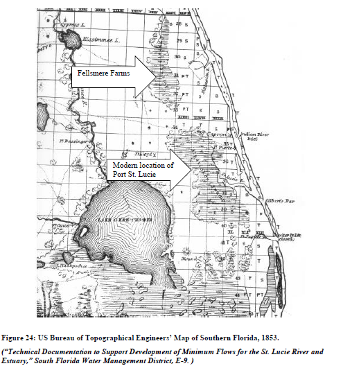
2. Oranges and Inlets – Nathaniel Osborn 2012. As the wetlands of the IRL were drained, the names of land features shifted over the decades to reflect their changing form. Today’s “Allapattah Flats” near the St. Lucie Estuary is undoubtedly a post-drainage name for the same feature listed on nineteenth century maps as “Halpatta Swamp” or “Alpatiokee Swamp,” but the lowered water table has left the area no longer resembling wetlands. Surveys of the lands west of the St. Lucie Estuary in the decade before the completion of the St. Lucie-Okeechobee Canal suggest that the land was covered with standing water for 8-10 months of each year. In the years which followed the post-1916 Drainage Act canalization, this drained region (like much of the IRL) became citrus groves, the town of Palm City, and the post-World War II development of Port St. Lucie (figure 24).273
————————————————————-
3. Bill Lyons, son of Ernie Lyons, from your blog. “During summer, sheet-flow from the Allapattah Flats converged in tiny rivulets into a deep pool with a sand bottom, the first of a series of pools connected by shallow streams of clear water that formed the headwaters of the South Fork. Dad loved that place, not just for its beauty but for its solitude. Itcould only be reached by Jeep during the wet season, so we hitched rides with the local game warden, who would drop us o and return for us later. Clyde Butcher’s photos of the upper Loxahatchee River are the nearest thing I’ve seen to what once was the upper South Fork. Then in the fifties, construction of the FloridaTurnpike cut off the flow of freshwater to the River. Soon saltwater intrusion crept up the South Fork,impeding the spawning of its fish, and the River began to die. In 1962, a friend and I drove to the former siteof the headwaters. The area had been bulldozed and the pool had become a cattle watering hole.”
5. The New York Botanical Garden – Green Deserts and Dead Gardens, A Record of Exploration in Florida in the Spring of 1921
J: Todd this is incredible. Thank you!
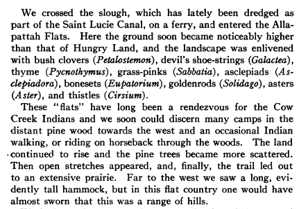
6. One more reference from The New York Botanical Garden, Old Trails and New Discoveries, A Record of Exploration in Florida in the Spring of 1919. It is pretty descriptive. Hungry Land – southeast / Allapattah Flats northwest.This is the kind of stuff I love reading because you know what he is describing. He describes the “distant pine wood towards the west” and a long evident tall hammock … one would have almost sworn … was a range of hills”. He is looking at the Orlando Ridge, the southern tip of which is Indiantown. You can still see what he sees when driving west on SR 70 or the stretch of turnpike that goes west though St. Lucie County.
J: So Todd, it sounds they drained Allapattah Flats and Hungry Land Slough in the 20s when they dredged the St Lucie Canal from Lake Okeechobee to the St Lucie River. What a bargain! Aggg! Thank God we are bringing some of it back! See you tomorrow!
Released juvenile little blue heron in wetlands Allapattah Flat, photo Todd ThurlowSo as you can see what is, what was Allapattah Flats is a long story! And we began to restore history!
The creative seed for this blog post dates back to 2011. On November 1st in 2011, my mother forwarded Bill Lyons, son of famed Stuart News conservationist and newspaperman, Ernest Lyons, an email that had been sent to me by Mrs. Sheri Anker of the St Lucie County Conservation Alliance. Sheri had come up with an idea to erect a series of signs throughout the St Lucie River highlighting the favorite spots that “Ernie” so passionately and lovingly wrote about throughout his career.
The following essay is Ernie’s son Bill’s response to my mother’s inquiry for guidance on creating a historic Ernie Lyons’ St Lucie River tour, as Sheri envisioned: “Travels with Ernie on his Rio de Luz.”
Bill’s reply was insightful, poetic, and bittersweet. Bill updated the piece in 2014 -after reading about the St Lucie’s “Lost Summer” of 2013, the tipping point causing a tsunami river movement resurgence that even from the grave, through republished essays in the Stuart News, was inspired by the spirit of Ernie Lyons. Recently my mother rediscovered Bill’s essay in her files and now seems like a good time to rethink the sign idea.
It is my wish that after we read Bill’s tribute to his father, we follow through on Sheri’s idea for signage along the St Lucie River. Indeed, it is difficult to mark what is “favorite” when you love it all, but one thing is certain, we must ensure that our beloved river and the spirit of Mr. Ernest Lyons continues so that “progress” in the future won’t mean a bulldozer.
Favorite Places on the River, by Bill Lyons
Ernest Lyons, my father, first came to Stuart, Florida in 1913 and lived there for most of his life. He worked at the Stuart News for 40-some years, retiring as editor in 1975. Dad loved to fish and above all he loved the St. Lucie River, an affection evident in his writings. A few years ago an admirer of that writing suggested erecting signage at Dad’s favorite places on the River. This is my response.
Ernie Lyons as a boy
Dad’s favorite places changed with the moods of the River. For instance, I’m fairly sure North Fork Bay wasn’t his favorite place the day he couldn’t find shelter there from what he called a Blue Norther. He had gathered my mother, my sister and me in his boat and set off up the River to look at a piece of land. It rained and blew all the way up the River, abated for a while as he walked over the property, and then poured buckets all the way back to Stuart. Dad never owned a boat with a cabin or a cover, and I don’t recall that Mother ever got into one of his boats again.
Classic Ernie Lyons as a newspaperman, Stuart News
Dad really did love the North Fork, though. Willard Kiplinger commissioned Florida artist Beanie Backus to do a painting for Dad – “Just contact Beanie and tell him what you want” — so Dad requested a view from the shore where the narrow North Fork opens out into North Fork Bay. Beanie took a boat out there, sketched the scene, and the finished painting hangs in our home today. Many times in the nineteen forties and early fifties, Dad drove us to Burt Pruitt’s Fish Camp, rented a skiff, and motored down to where two branches of the North Fork converge. The River then was alive with fish and birds and alligators, but by the late fifties, it was gone. Drainage from the Rim Ditch Canal (C-24) did so much damage to that part of the River that it lost its sparkle. I don’t think Dad ever went back to the North Fork; after that, he just lived with the memories.
Bean Backus, “The narrow North Fork opening out into North Fork Bay.”
When Dad wrote about festoons of asters along the banks and sprays of orchids hanging from oaks over the River, he was thinking of the South Fork in summer. He took me there many times and we caught lots of fish, but the magical memories are of the flowers and of the tarpon and manatees that came rolling by while we sat quietly watching. During summer, sheet-flow from the Allapattah Flats converged in tiny rivulets into a deep pool with a sand bottom, the first of a series of pools connected by shallow streams of clear water that formed the headwaters of the South Fork. Dad loved that place, not just for its beauty but for its solitude. It could only be reached by Jeep during the wet season, so we hitched rides with the local game warden, who would drop us off and return for us later. Clyde Butcher’s photos of the upper Loxahatchee River are the nearest thing I’ve seen to what once was the upper South Fork. Then in the fifties, construction of the Florida Turnpike cut off the flow of freshwater to the River. Soon saltwater intrusion crept up the South Fork, impeding the spawning of its fish, and the River began to die. In 1962, a friend and I drove to the former site of the headwaters. The area had been bulldozed and the pool had become a cattle watering hole.
Fork of the St Lucie, Sandra Thurlow
Dad loved many places on the River. Some nights he would drive over to Lighthouse Point (the one with the restaurant on US 1, not the development). He took a lantern, a single-tined spear, and a croaker sack and went wading for flounders. He knew just where they would be, hanging at the edge of the bar waiting for unwary fish and shrimp to wash by. A few hours later he would come home, dump a bag of flounders into the kitchen sink, and start cleaning them. Then the mud from Lake Okeechobee washed down the River and the flounders went away.
Dad loved the widest part of the River, where vast schools of mullet gathered along the north shore. Tarpon and snook, seatrout and jack crevalle would attack the mullet and drive them grey-hounding in waves across the River, often all the way to the shores of Stuart. Interactions between Plains wolves and bison were no more dramatic. Much of the action happened at night as we lay in our beds, listening to the mullet thundering across the River. When hurricane season approached, immense schools of fingerling mullet moved down the River, sometimes taking several days to pass Stuart. They too ran the gauntlet of snook and jacks, and residents flocked to the shore to fish. Who then could not love the River, unless he were a mullet?
Burt Pruitt’s Fish Camp, North Fork. St Lucie River
In my early years, Dad loved the lower St. Lucie around Hell Gate, that part of the River that separates lower Sewall’s Point from Port Sewall. Again, it was the fishing that brought him there. When winter storms blew, he could find shelter in the lee of Sewall’s Point, and that’s where he would be, trolling for bluefish or bottom-fishing for weakfish. After the months-long runoff from the ’47 and ’49 hurricanes, though, the fish did not return.
Where the River rounds Sewall’s Point it meets the Indian River Lagoon and together their waters flow over large seagrass beds on their way to St. Lucie Inlet. Dad loved casting for large seatrout on the grass flats, and it was there that he and I were fishing in Dale Hipson’s iconic photo that graces one of Dad’s books.
And of course he loved the inlet, where the River meets the sea. Dad was enchanted by the place he called the Sun Parlor, the channel that hooked north around Sailfish Point and spread out to feed the adjacent grass-beds. Ancient black and red mangroves hung in the water along the channel, and sheepshead and snappers could be seen swimming among the snags in the gin-clear waters on flood tides. Sharks were not uncommon in the channel, and queen conchs and large horse conchs lived in the grass-beds. If you wanted to see a roseate spoonbill in Martin County in the fifties, that’s where it would be. Dad spent countless hours in the Sun Parlor. Then the developers came in the late fifties, and it was lost.
“Ernie with son Bill and Pudge pop-corking at the Crossroads off Sewall’s Point, 1950s” Photo courtesy of Dr. Dale Hipson. Cover of The Last Cracker Barrel by Ernest Lyons
Dad loved Bessey Creek, a tributary of the lower North Fork, and once in the early fifties he accompanied me and two other boys on a camping trip to the upper reaches of the creek. Around the campfire at night, Dad told us of a remote pond connected to the main creek by a hidden stream that he found in his youth. We boys searched until we found it, and we took Dad back there to fish. Judging from the abundance of hungry bass in that pond, I don’t think anyone had been there for decades. There were no houses on Bessey Creek then, and we could spend days without seeing another human being. But around 1960 the county built a new road to extend Murphy Road across C-23 Canal. The road cut across upper Bessey Creek virtually on top of our old campsite and passed within 100 yards of the hidden pond. When I returned from the Army in 1962, I walked across a sand lot from the road to the bank of the pond and gazed at the empty bait cups and beer cans on its shore. Humpty Dumpty was off the wall.
Aerial maps suggest that Mile Lake and a few adjacent lakes in southern St. Lucie County may be ox-bows, formed as part of the North Fork but pinched off as the River meandered away. In his boyhood Dad camped and fished around Mile Lake, and he took me there many times. I don’t know if Dad knew Mile Lake had once been part of the River, but it may explain his affection for the place. He loved the River in all of its many parts, but I don’t know how he’d have felt about Mile Lake surrounded by homes and golf courses as it is now.
Ernie Lyons with Bass, possibly Mile Lake
Dad had a love/hate relationship with the St. Lucie Canal. Its discharges damaged the River downstream, and he campaigned tirelessly but futilely for the Army Corps of Engineers to manage it responsibly. Still, when many of his favorite places were gone, fishing remained good in the canal, and Dad could drive out and fish along its banks. Then, testing found some of the nation’s highest readings for pesticides and heavy metals in fish from the canal. That’s when Dad gave up fishing.
If anyone were to put up signage at Dad’s favorite places on the River, they would need lots of signs. And the signs should say “This was one of Ernest Lyons’ favorite places, a place of magic, until progress did it in. Sit quietly, look closely and try to imagine the sparkle that once was here.” If you can’t see the sparkle, it just looks like water. Or, more recently, like guacamole.
~Bill Lyons, son of Ernest Lyons
A mullet jumps at sunset, St Lucie River off of North River Shores, photo Todd Thurlow.
Biography of Bill’s father, Ernest Lyons
Florida Newspaper Hall of Fame, Ernest Lyons, 1994
Lyons began working as a reporter for The Stuart News in 1931. He also worked as an advertising salesman, printing salesman, then as advertising director for the paper. He became editor in 1945, serving until his retirement on March 1, 1975. He died April 6, 1990, at age 85.
Under Lyons the paper grew from a tiny independent weekly to a lively Scripps Howard daily. As editor, Lyons practiced community journalism at its best. He had a keen sense of what local people wanted to read and a zeal to guard their interests. Fearing that rapid population growth and urbanization might ruin coastal Florida, Lyons fought for protection of endangered water resources and wildlife habitats.
In 1965, his newspaper columns won the nationwide Edward J. Meeman Award for conservation writing. His writings, some composed 30 or more years ago, still are quoted by conservationists because they ring with enduring concepts and timeless values.
USGS 1958 Quad Western Martin and St.Lucie, slide Todd Thurlow, Time -Capsule Flights
Today, I present, yet another incredible Time-Capsule Flight by my brother Todd Thurlow. (https://jacquithurlowlippisch.com/todd-thurlows-time-capsule-flights/). This flight takes us on a tour over the Everglades, the Everglades Agricultural Area, Loxahatchee Slough, Allapattah Flats, Ten Mile Creek, and the St Johns River Marsh, fading in and out, so one can see what the landscape/waterscape looked like in 1958 using USGA topographical maps compared to today’s Google Earth maps.
What is most striking for me, is how undeveloped, how undrained, much of the land was in 1958, not really that long ago… 61 years ago. For reference, my husband, Ed, is 62 years young!
More than we can image has happened to South Florida since 1958…
For instance, when Todd flies by notice how little sugarcane and other crop production was taking place in the Everglades Agricultural Area just south of Lake Okeechobee compared to today. Now there are about 525,000 acres of sugarcane, back then, there appears to have been fewer than 50,000 acres of sugarcane in acreage.
Everglades National Park had been in place since 1947, but look at the difference in Whitewater Bay, as well as Taylor and Shark River Slough; and what about Florida Bay?
The Loxahatchee Slough region, near Jupiter, in Palm Beach County? Holy moley, notice how the once magnificent slough was made smaller by development encroaching from every direction, eventually leaving “Grassy Waters” at the southern end – as the sole water supply, via rainfall for all of West Palm Beach…
When Todd travels north over Marin, St Lucie, and the southern edge of Indian River County, perhaps the biggest shock for me endures, as I grew up in this area ~(For reference, I’m 55 years old 🙂
You’ll see that on the USGA map, southern Indian River, St Lucie, and Martin counties are shown in wavy blue as a gigantic marsh, at certain times of year, FULL of clean water!!!! Crazy! Since 1958 these lands have been drained (Ten Mile Creek) that was hydrologically connected to the marsh, through canals C-23, C-24 and C-25; and the waters of the St Johns “Stick Marsh,”( the headwaters of the St Johns River), a north flowing river, are now also drained south into the St Lucie River. Agriculture fields and nearby highways cover those most of those stick marsh lands today.
And the central larger marsh? “Allattah Flats,” also known as “Allpattah Marsh,” or in old military Indian war maps, “Alpatiokee Swamp? Well, the City of Port St Lucie, with over 250,000 residents, and acres of ailing greening orange groves, and more agricultural fields fill these areas today.
Just unbelievable, isn’t it?
Talk about “taking control of one’s environment. “Kind of cool, but I’d say we have really over done it, considering that now our waters, critical for life itself, are almost entirely impaired.
It is my wish that as the residents of Florida push their governments to work for cleaner water, and restore some of these lands, that we all keep in mind the history ofwhat the lands were, working with Mother Nature, not against her.
Todd’s Time Capsule Flights are an invaluable tool in recognizing how much human determination has changed these lands, and how a modern-day determination can restore them. Please click on below and enjoy! Thank you Todd!
An Incredible Flight! 1958 USGS Quads, the Everglades, Loxahatchee Slough, Allapattah Flats, and St. Johns River Marsh, by Todd Thurlow
1958 USGS Quads of the Everglades, Loxahatchee Slough, Allapattah Flats, and St. Johns River Marsh
This time capsule flight overlays three 1958 USGS Quadrangle Maps of southeast Florida from Florida Bay to the St. Johns River Marsh in Indian River County. You will see the following places: 0:30 Whitewater Bay 0:39 Shark River 1:44 The Everglades Agricultural Area (EAA) 2:20 Loxahatchee Slough 3:15 Allapattah Flats 3:35 Tenmile Creek 4:03 St. Johns River Marsh