-Lake Okeechobee’s northwestern shoreline on a beautiful day, 2020. Photo Ed Lippisch and Jacqui Thurlow-Lippisch  “LOSOM.” Sounds rather ominous doesn’t it?
You may have heard the acronym recently and wanted to get involved. Today, I will try to simplify the major aspects of LOSOM best known as the “Lake Okeechobee System Operation Manual,” by splitting the process into three sections, past, present and future. It is my hope that this helps the everyday-person make sense of a complicated process and provides tools for effective advocacy.
Getting involved with LOSOM is about the most important thing we can do to “be a voice for the estuaries” because it means influencing a very complex lake operating system that for years has favored water users at the expense of the estuaries. Over time, priorities change, it is time to be fair, and now is an opportunity to speak-up. This occasion comes along only every decade, or two…
So here we go!
I. Past
The ACOE’s lake operation systems entail a lot of complicated science, however, one thing we can all understand is lake level. The modern lake regulation schedules began in the 1970s. Outstanding author and scientist, Thomas E. Lodge, states on page 153, in his book, The Everglades Handbook, Fourth Edition : “Since the 1930s, Lake Okeechobee’s water levels, or stages, have been regulated in an effort to balance often conflicting goals.”
These original goals were defined back in 1948 in the“Comprehensive Report on Central and Southern Florida for Flood Control and Other Purposes,” when the ACOE reworked (some would say overworked) South Florida’s canal system. These goals or priorities remain with us today as we work through LOSOM. Understanding these goals gives us solid ground to stand on in an often shifting arena.
-1948 C&SFP map (Revised, 1982) 
The goals/so called benefits of expanding the canal system and draining Florida were the following: 1. Flood control; 2.Land Use (creation of the Everglades Agricultural Area, and more drained land for development throughout the system); 3. Navigation; 4. Fish and Wildlife; 5. Water Supply, and 6. Recreation.
What is not mentioned, nor was considered in times past, is “Health.”
In recent years, poor water quality, due to non-point and point source pollution build-up over many years, has led to large toxic algae blooms on Lake Okeechobee; unfortunately due to irresponsibility and carelessness, it has reached mammoth proportions. When discharged to the estuaries, St Lucie, Caloosahatchee, and the Lake Worth Lagoon (not yet formally considered an “estuary”) local economies, as well as wildlife and human health is threatened to the point of catastrophe.
The NOAA satellite image below shows a cyanobacteria bloom on Lake Okeechobee in July of 2016. Absolutely unbelievable. To deal with this dangerous situation, over the past couple of years, the Army Corp has implemented a Harmful Algae Bloom Deviation. It will more than likely become part of LOSOM.
-Lake O, NOAA satellite image 2016.  Table 11.2 below is an excerpt from Dr Lodge’s book and is extremely helpful in understanding the history of the Army Corp of Engineers’ regulation schedules and management of Lake Okeechobee. LOSOM will come next, starting in 2022.
-According to Dr Lodge, a 1913 Corp of Engineers’ report “established the wet season level of Lake O at 20.6 feet NGVD. Seasonal low was 19.2 feet. Since 1913 the lake has multiple canal outlets and is now smaller and enclosed by a dike (1933). Regulation schedules since the 1970s are listed below. CLICK TO ENLARGE TABLE BELOW.
After studying the chart, one can see that we are entering the 6th modern Lake Okeechobee regulation schedule.
As mentioned, right now 1. Flood control (this includes dike and flood water safety); 2. Land Use; 3. Navigation; 4. Fish and Wildlife; 5. Water Supply and 6. Recreation are the goals lake regulation schedules of the past have worked under. But as the HAB deviation tells us, times are changing and priorities must be defined by the times we live in.
Let’s think…
Which category do think has priority now? Which one/s had priority in the distant past? Why? Where do you want the priorities in the future? Should there be yet another priority such as health?
Now is the time!
II. Present
The image below, LAKE OKEECHOBEE SYSTEMS OPERATION MANUAL UPDATE, is from Feburary’s SFWMD Governing Board meeting (go to 133.38-205.25 to hear the discussion from Mr John Mitnick, P.E. Chief District Engineer, and the board.) If you have the time, watching this will be very helpful.
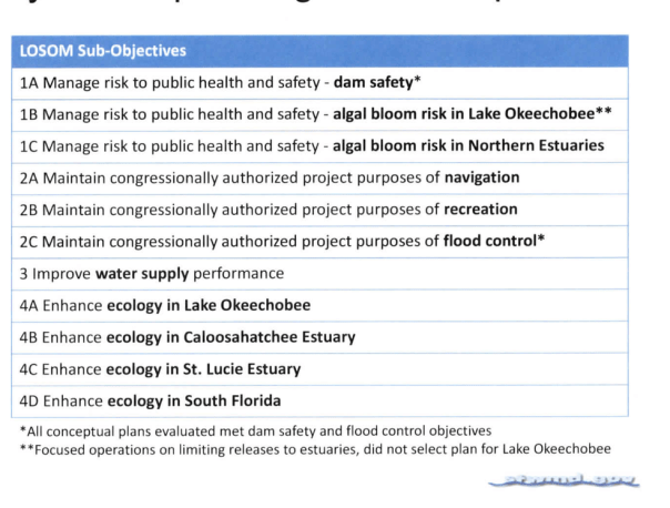
Mr Mitnick shared the slide below during this WATER CONDITIONS SUMMARY, which now includes LOSOM. Notice the word “health” is used a lot. Interesting.

The world of LOSOM is a world of scientific models. And it is these scientific models that will help determine the future. The South Florida Water Management District’s expertise as a local sponsor of the Central and Southern Florida Plan puts them in charge of the modeling for the Army Corp of Engineers. Groups of volunteer and experts have been discussing these models since January of 2019. They have narrowed the models down from over 120,000. Now you can jump in too!
Note the numbers to left of each sub-objective or goal. For instance, the number next to “Enhancing ecology in the St Lucie” is 4C. The scientific models that benefit the St Lucie are 4C models. The number next to “Enhancing ecology in the Caloosahatchee” is 4B. The models that benefit the Calooshachee most are 4Bs. The ideal lake operation conditions for these two estuaries are not quite the same. For instance, the St Lucie wants 0 discharges, but the Caloosahatchee needs some discharges due to salinity issues. When the LOSOM process gets to “balancing” these things will have to be worked out along with all the other stakeholder goals and wishes. Get the idea?
So here’s your chance. What is your priority for your water body or other? Of course they are all important but what stands out for you TODAY? 1. Flood control; 2. Land Use; 3. Navigation; 4. Fish and Wildlife; 5. Water Supply; and 6. Recreation and/or 7. Health.
Think Estuaries: St Lucie, Caloosahatcee, Lake Worth Lagoon, Biscayne Bay, Florida Bay, Lake Okeechobee itself? Once upon a time, Lake Okeechobee was once part of the greatest estuary in the world-our River of Grass!
In the art of negotiating, or “balancing,” as the ACOE calls it, start strong with your first priority. Ask yourself which category has taken a back seat? Maybe you are not pleased with any of them. Which priority should come forward? Perhaps its a combination. You decide!
III. Future
So where are we in this complicated process? The SFWMD will hold workshops for the board and public in the coming months. But consider getting involved now.
The SFWMD image below shows that we are in the green phase: January 2021-May 2021, where 13 models will be chosen from the 27,000. This is too much to think about. Just focus on your goal. Your number from the above chart. 
The yellow rectangle that is so hard to read says: “Iteration 2, Balanced Array of Lake Schedules” (May 2021-July 2021). After July we will enter the orange phase and all of the feedback (advocacy and input) will be “balanced.” Negotiated.
Negotiated in the public arena! When all is said and done, the new lake plan —the Lake Okeechobee System Operating Manual (LOSOM) —will take effect in 2022.
So speak up now! Write the Army Corp, the address is below or better yet, attend Monday’s February 22, 2021 meeting if possible. There will be others, but put your foot in the water now. 🙂
Even though, this has been a relatively complicated post, I hope it has helped simply the LOSOM process: thank you for being a voice for the estuaries and our waters!
IV. ACTION ITEM
PLEASE READ BELOW
Let’s seize this moment to advocate!
Join the Army Corps LOSOM meeting!
When: 10 a.m.-noon Monday, Feb. 22
Or call in by phone at (844) 800-2712.
The dial in access code is 199 737 9512. The password is 1234.
Can’t make the meeting?
Thank you!
-Lake O’s northwestern shoreline on a not so beautiful day, 2020. Photo EL & JTL


 Another part of the project is the 100-mile-long eastern perimeter levee, a 3- to 6-meter high earthen berm built to prevent flooding of farmland and urban areas. It runs along the eastern edge of the WCAs, marking a clear separation between the WCAs and urban areas such as Miami, Fort Lauderdale, and Coral Springs.