My husband, Ed, was able to fly the Baron yesterday. As the plane has been in service, we have not taken photos of Lake Okeechobee or the St Lucie River from a higher altitude in almost two months.
Because the satellite images have been showing Lake Okeechobee’s bloom lessening, I wasn’t sure what Ed would find. Well, he found a large blue-green algae bloom right outside the gates of Port Mayaca at S-308.
 http://eyeonlakeo.com/NCCOS%20HAB%20Images/index.html via Todd Thurlow
On his way back to Stuart, he also took pictures of the St Lucie Inlet showing plentiful seagrass recovery near the Sandbar at the confluence of the St Lucie River/Indian River Lagoon, the ocean/river looking blue and inviting ~ not like the black coffee sediment and toxic nutrient-filled discharges seen recently in 2013, 2014, 2016, 2017, and 2018.
I am thankful to the ACOE and all involved for this summer’s reprieve. The Saint Lucie River really needed it!
We must keep in mind that with all of the recent rain, of course, Lake Okeechobee is rising. Today lake is at 12.99 feet. Hopefully, in the coming and most active months of hurricane season, there will not be a tropical system that could rapidly increase the lake level. In years past hurricanes have brought as much as three or four feet. There are many factors, but usually, the ACOE starts releasing at 15.5 feet to protect the Herbert Hoover Dike’s integrity and those living south and in the shadow of our diked lake.
Humans may have figured out how to “control” the state’s water, but Mother Nature holds the final card.
 SFWMD 8-19-19
LAKE OKEECHOBEE AT PORT MAYACA AND LAKE O’S N.E. RIM SHOWING ALAGE BLOOM. IF S-308 were open, this bloom and freshwater that sustains blooms would be pouring into the St Lucie River/Indian River Lagoon. Photos by Ed Lippisch 3-18-19.


Looking toward Lake Okeechobee at S-80, A.K.A. “The Seven Gates of Hell.” These gates can be opened by the ACOEO to discharge water from Lake O into the St Lucie River. Photo Ed Lippisch 8-18-19.
 C-44 Canal connects Lake Okeechobee to St Lucie River, photo Ed Lippisch 8-18-19
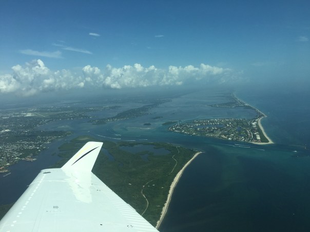
ST LUCIE RIVER/INDIAN RIVER LAGOON AT ST. LUCIE INLET showing nearshore reefs, blue waters, and recovering seagrasses ~even with high local rains and discharges from canals C-23, and C-24. This area between Sewall’s Point and Sailfish Point was once considered the most bio-diverse in North America. This year, 2019, there have been no discharges from Lake Okeechobee allowing the area to begin to recover from years of destructive discharges from Lake Okeechobee.


Flight Aware Track:
