Map for the “Performance Configuration” co-authored in 2009, incorporating Plan 6 ideas for sending more water south.
First thank you to Dr Gary Goforth for providing much of this historical data.(http://garygoforth.net)
There is a lot of controversy surrounding the idea of “sending water south,” mostly because in order to do so privately owned lands would be taken out of sugar productivity. This post is meant to share some of the history of ideas over the years to do so, not debate it.
As we all know, before the lands south of Lake Okeechobee were drained for the budding agriculture industry in the late 1800s onward, when Lake Okeechobee overflowed, ever so gently its waters ran over the southern lip of the lake through a pond apple forest, creating a “river of grass” that became the Everglades.
In the 1920s at the direction of Congress and the State of Florida the Army Corp of Engineers (ACOE) redirected these overflow waters that had functioned as such for thousands of years through canals C-44 to the St Lucie River and C-43 to the Caloosahatchee.
This achieved better flood control for agriculture and development but has caused an environmental disaster for the northern estuaries and for the Everglades.
The environmental destruction and safety issues of the Herbert Hoover Dike were noted early on. As far as the destruction of a local industry, the fishing industry in the St Lucie River was the poster child. This and many other reasons caused many people over the years to seeks “improvements,” to the overall ecological system.
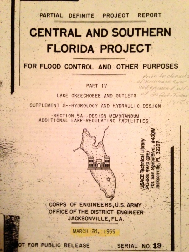
One of the first was the 1955 ACOE Central and Southern Florida Project Part IV. It was a proposal evaluating different options (plans) for “increasing lake outlet capacity. One component was “Plan 6,” a one mile wide floodway extending from the Herbert Hoover Dike to one mile into Water Conservation Area 3. For this report, Plan 6 was the recommended improvement. Dr Gary Goforth notes discharges to the St Lucie would have been lessened about by half, but “not eliminate lake discharges to the St Lucie River.” In the end, the entire plan was not acted upon as many tax payer paid plans are not…but Plan 6 was not forgotten…
Photos taken of 1955 ACOE CSFP Report courtesy of Dr Gary Goforth.Floodway 1955
Various references to Plan 6 and a floodway.
Dr Goforth also notes a “more robust plan,”a plan co-authored in 2009 by Karl Wickstrum, Paul Gray, Maggy Hurchalla, Tom Van Lent, Mark Oncavgne, Cynthia Interlandi, and Jennifer Nelson. (See first photo in this blog.) This plan is referenced by Mark Perry in his well known “River of Grass” presentation.
Mark Perry’s drawing in his presentation for “River of Grass,”used today, 2014.
The Art Marshal Foundation (Art was one of the great conservationist of the early 1960/70s environmental movement and has a wildlife preserve named after him) also notes in their literature that Plan 6 is traceable to the Marshall Plan-1981.
“Marshall Plan 1981 to Repair the Everglades, Why Plan 6 Will Work.” Marshall Foundation publication 2013, Version 2.2.
Most recently in 2013, the Rivers Coalition published on its website “Plan 6 Flowway, River of Grass, Missing Link.”
You can learn more about this version of the plan by clicking on the above link.
All of these plans, I believe, are one way or another based upon the 1955 ACOE Report. it may not have come to fruition but it certainly provided a lot of inspiration!
Also last year, Senator Joe Negron was able to secure $250,000 for a University of Florida study that should occur in 2014 for “Sending more water south.” Wonder what their plan will recommend?
If history repeats itself, even more Plan 6 versions will be created. In any case, let’s keep pushing for change to save the estuaries and find some way to move more water south. And thank you Army Corp of Engineers for the inspiration…
Paint colored shocking green algae at the gate entering Lake Okeechobee, 2009. (Photo from video by Jacqui Thurlow-Lippisch.)
I am well aware that the St Lucie River and Indian River Lagoon have location specific e. coli bacteria problems, as well as “overall water quality problems,” due to our local canals. This summer has been a great example of such with our SLR/IRL waters colored putrid brown all the way to the St Lucie Inlet just from releases from C-44, C-23, and C-24 canal basin runoff releases.
This is why it is beyond my comprehension, that with such terrible local water issues, our state and federal agencies can legally and in good conscious, “if necessary,” on behalf of flood control, release more nutrient, sediment filled waters into our SLR/IRL through Lake Okeechobee when they know that those waters often contain Microcystis Aeruginoas, a cyanobacteria that can produce health threatening toxins through its blue-green algae blooms.(http://www.doh.wa.gov/CommunityandEnvironment/Contaminants/BlueGreenAlgae.aspx)
Various 2013 SLR photos of microcystis aeruginoas, cynanobacteria. (Bob Voisenet, Mary Radabaugh, Jenny Flaugh, Douglas Ashley, Gary Hendry.)
In 2013, the Martin County Health Department, through spokesperson, Bob Washam, urged residents to avoid contact with the algae in the entire estuary from the St Lucie Canal to the St Lucie Inlet. Luckily with our local, “yuk” releases, we have not had that situation occur yet in 2014.
I have had two personal experiences witnessing these blue-green blooms. The first was during a boat ride into Lake Okeechobee, September 5, 2009, and the second was last year (2013) with the Everglades Foundation team, at the St Lucie Locks and Dam when the ACOE was releasing. As we walked over the gates, I clearly saw bright blue-green algae on the side of the dam allowing in Lake O water. Believe it or not, the SRWMD was testing the water right there… Mark Perry from Florida Oceanographic was with me and I ask him:
“Mark, is that “toxic” blue-green algae?”
Mark replied:
“Yes, blue-green algae can be toxic is most prevalent in fresh water systems. It is often in the lake.”
“And they are releasing it into our river?!”
I stood there in a daze….amazed.
Then I recalled the boat trip I had taken with my husband and dogs in 2009, and how we had seen the blue-green algae clearly along the edges of the locks while going into the lake and I had videotaped it. I am including some photos I took of that video below.
When Senator Rubio visited Stuart on behalf of the SLR/IRL, I told this story….I have told it many times at many official meetings to no avail. I think it a significant issue. Anyway…
So far this year, with the releases from our local canals, toxic algae, or Cyanobacteria, has not been reported in the SLR/IRL. It could be in the future, but it is less likely than when the ACOE is releasing from the lake. Why? Because often when they release from the lake it is TREMENDOUS amounts of freshwater, even more than comes from our local canals. Plus the blue-green algae is already in the lake as its fresh.
According to Bob Washam, blue-green algae was first reported around 1995 and it was blue! They thought it was a paint spill. The outbreaks have been more common since this time the worst being in 1998. Whether blue or green in color, it is bright. Very bright. You can see it.
How could our government, in essence, “poison its own people,” and how can we allow this, especially when we can see it?
We must push our government for change. Health, safety and welfare is something we rightfully deserve. Send the water south.
South Florida Developer headline 1931, “Locks in Canal Closed; Fishing to be Benefited. (Newspaper courtesy of historian Sandra Thurlow.)Written minutes from a Martin County Commission meeting in 1931 asking the state to close the locks, mentioning destruction to the river, and the importance to fishing industry. (Photo Martin County archives.)
The St Lucie Canal connecting Lake Okeechobee to the St Lucie River was constructed at the request of the state of Florida, the US Federal Government, and the local Martin County Chamber of Commerce, by the Army Corp of Engineers from 1915-1928. As this antique newspaper article of the Florida Developer above shows, by 1931 the Martin County Commission was already asking the state of Florida to close the gates and reporting clear evidence of the destruction of the St Lucie River/Indian River Lagoon.
I must thank my mother, historian Sandra Thurlow, for sharing this information and the photos in this post. She transcribed the 1931 article from the Florida Developer, a Stuart paper of the era. It reads:
South Florida Developer, November 6,
1931, LOCKS IN CANAL CLOSED; FISHING TO BE BENEFITED
Job of Checking Water Movement Was Completed Saturday TO KILL HYACINTHS; Fishermen Look For Decidedly Good Fishing the Winter
The east locks of the St Lucie Canal were closed Saturday, after being open nearly two years. In that time the level of Lake Okeechobee has been reduced from 18 to 14 feet.
The work of closing the locks began Friday morning under the direction of engineers for the Okeechobee Flood Control District. When they finished the job Saturday night, water continued to pour over the dam about as fast as before, in spite of the fact that the level of the canal had been raised 7 feet.
This morning the crew went to the west end of the St Lucie Canal to close the locks there and thus check the flow of water from the Lake.
The closing of these locks is regarded as highly important to the people of Stuart and adjacent communities, primarily because as long as they remain open, the ingress of water from the Lake made the St. Lucie River fresh, driving out the salt water fish and bringing in hyacinths. With the water cut off from the Lake, it is expected that the St Lucie River will again become salt and this should bring back the fish and kill the hyacinths. Fisherman say it will take about 30 days for the effects of the is change in water to be felt, but they are exultant that this change had come about in time to promote good fishing in local waters.
The minutes from the Martin County Commission meeting in 1931 also shown above are a bit harsher. The minutes state:
Be it resolved that the Board of County Commissioners herby instruct the Clerk to write the Trustee of the Internal Improvement Fund petitioning that they closed the gates at the Lake end of the St Lucie Canal until April 15, 1931, for the reason that the constant discharge of a large volume of dirty fresh water into the St Lucie River has killed all the shell-fish, driven out salt water fish from the river, filled the river with hyacinth and polluted the St Lucie River as to completely take away its attractive features and ruin its commercial value to our community.
According to local Everglades SLR/IRL expert, Dr Gary Goforth, (http://garygoforth.net/resume.htm), 1931 was the first year the amount of water released from Lake Okeechobee in to the St Lucie River was documented. Although there is no documentation of the releases that occurred prior to 1931, in 1931 it is documented that 1,414,414 acre feet of water was released from the lake into the river. This is over three times as much as was released into the SLR from Lake Okeechobee in 2013, (419,951 acre feet.)
The historic photos below document and show local people taking the water hyacinth issue into their own hands.
Downtown Stuart in 1931 showing over abundance of water hyacinth in SLR.(Thurlow collection.)South Fork of the St Lucie River, hyacinth removal, Rod and Gun Club-effort to solve problem with herbicide and dynamite, 1949.( Thurlow collection.)SLR filled with hyacinth, near Treasure Island. (Thurlow collection.)
On August 3rd at 10AM the people of Martin and St Lucie counties, on behalf of their government, will ask one more time for the state to close the gates from Lake Okeechobee to the St Lucie River/Indian River Lagoon.
As we have seen this summer, we have enough problems with our own local runoff that has been expanded since 1931 to include the building of C-23, C-24 and C-25 as well as the widening and deepening of C-44 for its enlarged “local” runoff. Things must change, we have known this for a very long time. Finally there are enough of us to make a difference.
Hope to see you at the rally and may the state and federal government know that we will never stop asking, some would say demanding, that the ACOE, through the federal government and the state of Florida “close the gates!”
C-44, C-23 and C-24 basin runoff discolors the waters of the SLR/IRL while exiting the St Lucie Inlet 7-19-14. (Aerial photo, Ed Lippisch.)All Photos were taken 7-19-14 and are showing C-44 basin runoff along with C-23 and C-24 runoff off. Pictured are Sewall’s Point and Sailfish Point along the SLR/IRL. Water exits at the St Lucie Inlet going mostly south to Jupiter Island over nearshore reefs. The plume is significant but not as large as the summer of 2013 when the ACOE was releasing from Lake Okeechobee as well. (Photos by Ed Lippisch.)
The river looks awful right now as the photographs taken Saturday, 7-19-14, by my husband show. Why? They are not even discharging from Lake Okeechobee…yet.
We have terrible problems with our local canals and adding the Lake discharges on top of it is a crime. The state, federal and local governments are working slowly to improve the situation through CERP (Central Everglades Restoration Project) projects but improvement is very expensive and cumbersome.(http://www.evergladesplan.org/pm/projects/proj_07_irl_south.aspx)
The C-44 Storm Water Treatment Area/Reservoir the governments are working on now will cost millions of dollars and store only some of the discharges from the C-44 we are getting today. But there must be more. We must learn more. We must keep pushing and helping our governments move along.
The best way to do this is to know how to read the information on water discharges yourself.
Last summer, when the discharges from Lake Okeechobee threw our already ailing river into toxic status, Boyd Gunsalus, one of the the leading scientists (and certainly coolest) at the South Florida Water Management District, showed me how to find the water discharge statistics, and today, in case you do not know, and are interested, I am going to show you.
FIRST THE LAKE AND C-44 BASIN
This link (http://w3.saj.usace.army.mil/h2o/reports.htm) of the ACOE at Lake O. will show you the level of the lake, and whether the ACOE is releasing from the C-44 canal, and or Lake O.
Go to the site above and on the right hand side you will see, St Lucie Lock, S-80 Spillway. Click on it. A chart will come up arranged by dates. (The data is always one day behind.) Look for FLOWS CFS (cubic foot per second) in the 3rd column. Today’s is 260 cfs. : 20JUL14 14.46 0.58 260 0. 00 270 0.0 7 30.07 1018. 2 0.00
Now go back to the same link and look at, Port Mayaca Lock, S-308 Spillway. Click on it. Again look for 3rd column, FLOWS CFS.. Today reads “0.” The gates from the lake to C-44 are not open. 20JUL14 13.55 14.40 0 0.00 270 0.0 9 30.04 1017.3 0.33 0.00
Now if both S-80 and S-308 are open you have to add the numbers together to know how much total cfs are coming into the SLR/IRL. And to figure out how much water is coming in just from the lake, subtract the S-308 number from the S-80 number which will always be larger.
To learn how high Lake O. is go back to the link, go to the chart and hit CURRENT LAKE OKEECHOBEE LEVEL. Today it is 13.66 feet. “Current Lake level is: 13.66 (ft-ngvd)”
OTHER CANALS
OK, now for C-23, C-24 and C-25.
Now, go to this link, the SFWMD’s web site: (http://www.sfwmd.gov/portal/page/portal/sfwmdmain/home%20page) 1. Look for the tab “Managing and Protecting Water;” look under and to the left of this tab for a small title reading “Scietists and Engineers,” click on this and go to LIVE DATA. 3. Go to the top link “Water Conditions-Regional Realtime Data, Status of Water/ Control Gates.” 4. Go to FT PIERCE and click right on the Ft Pierce link. A confusing chart will come up.
Look for these things:
1. S-49. S-49 is the opening for C-24.
2. S-97. S-97 is the opening/gate for C-23
3. S-99. S-99 is the gate for C-25.
Mind you C-23 and C-24 run into the St Lucie River’s north fork and main area and C-25 dumps directly in the IRL at Taylor Creek close to the Ft Pierce Inlet. So C-25 is not coming through the SLR and St Lucie Inlet like the rest of the sludge but it is important to know C-25 too as it is heavily destructive to the IRL.
OK, if you have been able to follow me so far. Once you open the SFWMD pages and get to FT PIERCE and see the weird chart, find the corresponding gate numbers I gave you above, and click on the the second row’s PLOT little box and arrow. Once this opens up, you will see a chart corresponding to discharges that looks like a wave or like boxes. The hight of the box or wave corresponds to a number on the left side of the chart. For instance: Today, S-49 (or C-24) is 450 cfs; S-97 (or C-23 ) is around 350cfs; and S-99 (or C-25) is around 100 cfs.
(I know there are a duplicate gates sometimes but I ignore them and just read one. They seem to say the same thing.)
Now to add up the cfs for “today:” C-23=350; C-24=450; C-44 at S-80 =260; S-308 from lake, 0. Today’s total incoming discharge water is around 1060 cfs cubic feet per second coming into the St Lucie River/Southern Indian River Lagoon.
Last week it was twice or three times this much. The discharges occur after it rains, long after and then finally slow down like they are now.
I do hope this has been helpful and that your head is not spinning or that you can save the links and instructions and try it when you have time. Call me if you have questions and want to learn, 772 486 3818.
It is important for the public to keep up with this and let the ACOE and SFWMD know we are watching what they are doing, so one day I don’t have to choke when I see the tab “Managing and “PROTECTING” water.
Aerial photo of C-25 canal depositing what DEP and SFWMD note in their Eco-Summary literature as “nutrients and agriculture chemicals into the Indian River Lagoon.” (Photo Ed Lippisch, July 10, 2014.)
Ed and I returned from California on July 9th and within 24 hours he was up in his plane and took these photos of C-25’s Taylor Creek outlet in Ft Pierce releasing excessive rain water runoff into the Indian River Lagoon. Still recovering from the three hour time difference, I gladly stayed home!
C-25 runoff into IRL. (Photo Ed Lippisch 7-10-14.)
The C-25’s canal outfall, although not connected to Lake Okeechobee, is one of the most dramatic and heartbreaking sites of our Indian River Lagoon’s destruction as it releases very close to the Ft Pierce Inlet so the difference in the water color is extreme. C-23, C-24, and C-44 releasing into the St Lucie River are probably quite similar, however, because the St Lucie River is dark in color and not close to an inlet to the ocean–the brown on brown water does not give the same effect as C-25’s brown on blue.
C-25 canal in Ft Pierce. (Photo Ed Lippisch 7-10-14.)
During last year’s heavy releases from Lake Okeechobee by the ACOE, my husband Ed and I flew up to Ft Pierce and flew the entire length of the C-25 canal which attaches to the C-24 canal, which in turn attaches to the C-23 canal. The water can be”made” to go in any direction by the South Florida Water Management District for agriculture purposes or otherwise. So water from C-23 or C-24 could theoretically be moved into C-25 and visa versa.
So anyway, Ed and I were taking a video for Dr Edie Widder of ORCA who is studying the water issues of the area. The ride was so bumpy and windy I became very sick which is not unusual for me in airplanes.
“Ed can you turn around?” I think I am going to puke.” I muffled through the microphone.
“Sorry babe, we’re in for the long haul with this wind; we should just follow the canal in this direction and ride it out….”
At that point my jacket in the back storage area flew out of the Cub and I envisioned it going over Ed’s face and us crashing, but it did not, and instead floated to the ground below. I held my stomach wondering what the person or cow who saw the jacket fall to the ground thought, hoping it did not land on someone’s windshield.
That trip, along the C-25, C-24 and C-23 back to Stuart was the worst ride of my life and I got sick many times while looking over mostly acres of orange fields and other agriculture. I saw some cows and then development as we got closer to the coast. I really just remember that is was acres and acres of land.
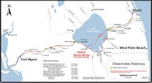
In the wind, the trip took over an hour from Ft Pierce, inland, south, and then back to the east coast of Stuart. The map below shows how the canals are connected and you can see the path we took–like a giant tall open rectangle.
Canal and basin map SLR/IRL. (Public.)
There is great literature on the C-25 and from what I have read the state agencies have been aware of the destruction caused by the canal for many years.
The ECO SUMMARY written by the Florida Department of Environmental Protection 1998, unfortunately, mostly still applies today, as the Indian River South Plan, has not come into being yet. The Indian River South Plan is a component of the Central Everglades Restoration Plan or CERP, that was approved by Congress around 2000. This plan would and hopefully will, one day, acquire lands, to hold water so it doesn’t just run untreated into the lagoon.
C-23, C-24 and C-44 are part of this IRL Plan as well, and as we know we have been fortunate this year and in recent past years to have been appropriated partial monies by our US Congress, the state of Florida and Martin County to build the C-44 Storm Water Treatment and Reservoir system–they are building it now.
But back to the C-25 the Eco-Summary. This link below interestingly states:
“The C-25 Canal was created as past of the Central and Southern Florida Flood Control Project (1950/60s) and discharges into the Indian River Lagoon…The section of the lagoon currently impacted by discharges from C-25 comprises one of the best remaining segments of the lagoon, namely the area just north of Harbor Branch Oceanographic Institution to the Ft Pierce Inlet…Thus C-25 potentially impacts the best of the best.”
“C-25 delivers a greater volume of water and thus a great net pollutant load that the other major upper east coast drainage canals C-23, C-24, and C-44. ( A surprise to me.) C-25 has been shown to transport pesticides, polyaromatic hydrocarbons, and heavy metals into the estuary as well as offshore…”
As you would expect, the C-25 is an “impaired” water body and was determined as such by the Department of Environmental Protection in 2003. Yet the IRL, from Vero to Ft Pierce Inlet, has been designated by the state as a protected Aquatic Preserve since 1975.
Did I just write that?
An impaired canal full of heavy pollutants has been running into an Aquatic Preserve?
Yes, I just wrote that. This is the truth.
This to me is even more heartbreaking than the photo. To know “we” have known the situation since the 1970s really and have not fixed the issue is a crime. We are all guilty as it is we that direct the course of our government.
So please don’t forget:
“The power of the government is derived from the consent of the governed….”Let’s keep pushing our elected officials and be prepared ourselves to do what it takes to fix this mess!
Thank you for reading my blog and for caring about our rivers.
Aerial of the confluence of the SLR/IRL off of Sewall’s Point, June 27th, 2014. (Photo courtesy of Scott Kuhns.)
If there is one thing constant about the St Lucie River/Indian River Lagoon’s problems, it is that they are multi-layered and complex. I believe this is one reason it has been so hard to “fix.” If there were just one problem, it would be easier, but there is not one problem, there are many.
So, today I wanted to focus on C-44 basin runoff, again, as it has been in the news a lot, especially the two weeks since I was gone as I heard it really rained and we even got our first named hurricane.
The photo above shows the waters just off of the tip of Sewall’s Point on June 27th, 2014. Disgusting.
Basin map Martin/St Lucie SLR.
The basin map above reminds us of the C-44 basin’s location in southern Martin County. The “basin” is the large area surrounding the C-44 canal in black lines. As we know, this area is largely agricultural and was expanded over the years to drain more land than nature intended.
Through permits with the South Florida Water Management District the agricultural businesses are allowed to use water from the C-44 canal for irrigation when needed, especially during the “dry” season. The Army Corps of Engineers manages the level of the canal mostly for agricultural use; this is an historic relationship. In spite of “best management practices” much of the water used to irrigate their fields, runs back into the canal, over and over again, filled with fertilizers, pesticides, herbicides, etc…This is the untreated, polluted water that goes straight into our rivers.
As we can see looking at the canal map, over the years, the C-44 basin has become tremendous in size in order to drain land for agriculture and development. Millions of gallons of water come off these lands when it rains, as has been the case the past couple of weeks.
This recent photo below by local river activist and fishing guide, Michael Conner, shows what the C-44 basin water looks like when it comes out of the S-80 gates at St Lucie Locks and Dam, the same gates that are used when water is released from Lake Okeechobee when the ACOE opens S-308 at the lake. This can be confusing because usually we associate this type of photo with releases from Lake Okeechobee. S-80 can release just C-44 canal water or “just lake water,” or both lake and C-44 water…
Releases from S-80 from the C-44 canal at St Lucie Locks and Dam, July 2014. (Photo courtesy of Michael Connor.)
So why haven’t we talked about the C-44 basin until this summer, or seen or very much about it in the newspaper “before?”
Well, it is confusing to the lay person, and I don’t claim to know everything, but I will explain what I can.
Generally, in the past, the ACOE did not usually release the C-44 into the river during the summer…but this summer they are. Why?
Well according the the “Environmental Impact Statement (EIS) for the 2008 Lake Okeechobee Regulation Schedule (LORS),” the document the ACOE uses to manage Lake Okeechobee:
“All alternatives assume back flow from the St Lucie Canal, C-44, to Lake Okeechobee to be allowed to occur at lake stages of 14.50 ft or 0.25 from the bottom of the the lowest non-baseflow regulatory zone, whichever is lower.”
Basically this means that under most circumstances if the lake is under 14.5 feet, which it is now, (13.38), the ACOE will “back flow” C-44 canal runoff water into the lake through S-308, rather than sending it east to the SLR/IRL through S-80. This summer the ACOE has chosen not to do this, so we are getting C-44 basin water released into the SLR/IRL so the water looks gross. In the ACOE’s July 11th, 2014, public periodic scientist call email statement, explaining their choices, it reads:
“The Water Control Plan deliberately allow some flexibility to consider real time and forecasted conditions and decisions made within the guidance provided by the Water Control Plan…for the specific decision not to flow water from the C-44 basin into Lake Okechobee since 12 June 2014, the conditions that we took into consideration were rising lake levels, water supply, remaining duration of the wet season and proximity to the low sub band….the 8 July report from the South Florida Water Management District evaluates the condition of St Lucie Estuary and states “salinity at US1 is within the preferred range for oysters in the mid estuary.”
Photo of SLR/IRL off Sewall’s Point yesterday, 7-15-14. (Thank you Ed Lippisch)
Hmmm? Obviously the SFWMD’s salinity report was not that of Mark Perry’s at Florida Oceanographic…Let’s read and take a look.
Mark Perry feels the ACOE should be back flowing the C-44 water into the lake. He says:
“According to the Water Control Plan for the Lake the Corps should be opening S-308 and back flowing this local basin runoff into the lake when the lake is below 14 feet and the C-44 is above 14.5 feet but they have chosen to make steady releases from the C-44 basin through S-80 into the St Lucie at near 1000 cfs since June 14. Not so good outlook for the St Lucie Oysters…”
Please view his chart below that shows what has happened to salinity levels since the C-44 has been flowing into the SLR/IRL. (Mind you C-23, and C-24 are also dumping their basin runoff water, but C-44’s basin area is larger.)
Salinity is going below safe levels for oysters since the C-44 basin at S-80 has been opened.
On the other hand, friend of Mark Perry, Kevin Henderson, long time advocate for the SLR/IRL and founding member of the St Lucie River Initiative, feels the ACOE is perhaps trying a strategy that will help the St Lucie in the “future.” Kevin states:
“I firmly disagree that the Corps should always run C-44 drainage west until the Lake reaches 14.5. That is the pattern that gets us the most continuous lake and C-44 drainage into the fall, and the the patten that kills oysters…It is not basin runoff that kills the estuary, it’s months of continuous discharges at rates that never let salinity recover. This is why I advocate sending C-44 drainage west only when local salinity could recover for a while, then send it east again and do not let Lake O get high enough to wreck us with longer term discharges…”
I think he’s saying, the ACOE, by not consistantly filling the lake up with C-44 basin water during summer, may be avoiding long term runoff into the SRL/ILR in the future come fall…
Hmmm?
Both Mark and Kevin have a point.
My non-scientific perspective?
I think the ACOE was so taken aback by the wrath of the general public last year, the River Warriors, the River Kidz, the River Movement, the Stuart News/media, as well as some politicians, that they will do “almost anything” not to release water from Lake Okeechobee into the St Lucie River/Indian River Lagoon if they don’t have to.
By letting the C-44 basin water go into the river and not the lake, if a hurricane comes, there is just that much more room in the lake to hold the water so they don’t have to dump here and listen to us scream….
St Lucie Estates, On the Beautiful St Lucie River, Stuart, Florida, 1926 booklet. (St Lucie Estates, Inc.)
In the 1960s, I grew up in St Lucie Estates, Stuart, Florida, the neighborhood just north and south of Kreugar Creek close to the St Lucie River, not too far from Downtown Stuart. Until I was ten, we lived at 109 Edgewood Drive. I loved that little brick house. I had full reign over the neighboring empty lots and could ride my bike on the “black road,” to get to a park, along the river, next to the Granfield’s house. The kids of the neighborhood often met there, and we pretended the gigantic, falling Australian Pine was a ship and we made it into our fort. We traveled across oceans. We fought pirates. It was a wonderful childhood.
As a kid, I had no idea of the long running issues with the St Lucie River/Indian River Lagoon, the canals, and Lake Okeechobee. I just knew I loved the river. I loved that I could escape there. Even when I was in high school, living in Sewall’s Point, I’d steal away and sit under the bridges and “think” in the privacy of the river’s ancient calm.
Today, at half a century, I am still in love with the river, but I view it in a different light. A light of history and destruction. My heart aches because I really don’t know if it can make it against the odds. Now that I am older, I know its complete destruction has been coming for a long time, kind of like a cancer. I am miffed that since 1923, when the ACOE first connected the C-44 to the South Fork of the St Luice, that locals were not able to stop the “drainage machine,” as Ernie Lyons, previous editor of the Stuart News, called it. I am miffed also that the state and federal agencies would so blatantly kill an ecosystem.
When I look through my mother’s historical data and read the ads for selling land in Stuart in the early 1900s, it is ironic that they all incorporate the St Lucie River into their sell while they were killing her.
“Stuart on the St Lucie, 1907;” “St Luice Estates, On the Beautiful St Lucie River, 1926;” “Stuart, Atlantic Gateway to the Gulf of Mexico, ca. 1926.”
The are all bragging about draining the Everglades; they are bragging about the digging of the Okeechobee Waterway from Stuart to Ft Meyers thorough Lake Okeechobee; they are basing the draw of the Stuart area on its location/proximity to the St Lucie River/Indian River Lagoon, and yet they seem to have no clue that by supporting the over draining and over dredging of everything, they have created the rivers’ own destruction!
All news ads and photos from Stuart on the St Lucie, by Sandra Henderson Thurlow, 2001)
;
This is an excerpt from the St Lucie Estates sales booklet:
” St Lucie Estates is situated in one of the most gorgeous spots in Florida—the beautiful St Lucie River County…The St Lucie and the Indian River meet here to form one of the most wonderful bodies of water in the world—one hundred miles of navigable waterway, edged with luxurious tropical foliage able white sandy beaches…”
“In the introduction to my mother’s book, Stuart on the St Lucie, she writes” Pioneer businessmen of Stuart…realized the St Lucie River was the town’s greatest asset. To foster awareness they of the town’s superior location, they used “Stuart on the St Lucie” in promotional literature, on signs and as newspaper headings. Time has not changed the fact that the St Lucie River is the best thing about Stuart.”
Promotional signs to “Stuart on the St Lucie” along Dixie Highway from Jacksonville read as shown on list and stated, ca. 1919. (SHT).
The St Lucie is still the best thing about Stuart, and now we know better. The drainage of lands surrounding the St Lucie/IRL was too extensive. In order to make way for agriculture and real estate development. The St Lucie River and Indian River Lagoon now take on more than twice what was originally drained into them.
The excess fresh water and pollutants have all but killed the St Lucie River/Indian River Lagoon. This chart shows the original drainage in green and today’s drainage which has been added to the green area in yellow. Lake Okeechobee’s discharges, in pink, are often on top of this. It is too much.
The old adage says “history repeats itself.” Well, here in “Stuart on the St Lucie,” history cannot repeat itself anymore. We must create a new future.
Drainage changes to the SLR 1900s to today.(Citizen’s Report to Congress, 1995)
Fresh water releases from basin runoff through local canals C-23, C-24, and C-44 as well as polluted fresh water from releases from Lake Okeechobee through C-44, cover near shore reefs off of Stuart and Jupiter Island. (Photo MC archives, 2011.)
The concept that fresh water is a “pollutant” is sometimes confusing as we typically associate pollution with heavy metals, nutrients like phosphorus and nitrogen from fertilizer, and muck accumulation, on the bottom of the river, from sediments running off of lands, through canals. Believe it or not, too much fresh water is just as polluting and has dire consequences for the St Lucie River/Indian River Lagoon.
This is historically ironic as well, as when the Ais Indians lived in this area, the St Lucie River was a large fresh water “stream.” Throughout history, most of the time, the “St Lucie,” was not connected to the ocean. The natural inlet at what was later called “Gilbert’s Bar” by the Spanish was sometimes open, sometimes not, but never for too long, and the inlet opening was much smaller and shallower than today’s St Lucie Inlet.
Yes, we are going back, before we go forward, but history is important to know!
The “St Lucie Inlet” was permanently opened by hand using shovels, in 1892, by local pioneers who wanted access to the ocean for trade and communication. They had no idea that by doing this they would create “the most bio-diverse estuary in North America.”
As the salt water came in and mixed with the fresh water of the St Lucie and the “fresher than today’s water” of the Indian River Lagoon, one ecosystem, a freshwater ecosystem was destroyed by the salt, and another was born.
Over time, more fish and critters entered the St Lucie/ Southern Indian River Lagoon than at any other time in known history. The forks of the St Lucie, north and especially north, remained more “fresh” as the salt water usually did not go up that high into those areas. Perfect! Salt and fresh water fishing! It was a unique situation and as mentioned in the day before yesterday’s blog, presidents and other famous people swarmed to the St Lucie for its amazing fishing during this era, and all enjoyed.
Then things changed. In the late 1920s and early 30s, due to flooding of agricultural lands and bad hurricanes killing people living and working in the southern area surrounding the lake, the Army Corp built the C-44 canal from Lake Okeechobee to the south fork of the St Lucie River. Then in the 50s and 60s they built canals C-23 and C-24 as part of the Central and South Florida Flood System, another “flood protection project.” Although all of these drainage programs helped agriculture, especially the sugar industry south of the lake, and citrus, in mostly St Lucie and parts of Okeechobee counties, as well as greedy developers, it did not help the St Lucie River. In fact, these drainage canals have been slowly killing the St Lucie and Indian River Lagoon ever since.
How?
Through many things, but believe it or not, mostly through fresh water.
Once the estuary (St Lucie/IRL) became brackish, a mixture of fresh and salt water, this delicate balance was important to the fish, mammals and others critters that made the river/lagoon their home in this new found paradise.
Briefly, I will summarize some of the killer effects of fresh water on its residents:
1. Fish: When there is too much fresh water the fish get lesions. This is from a fungus that only can live and operate in a fresh environment. The name of the fungus is Aphanomycesinvadans and its spores get into fish skin when temperatures are low and water is fresh causing horrible lesions. More lesions have been reported over time in the St Lucie River that any other site in Florida according to the FDEP report at the end of this blog. The worst outbreak was in 1998 after the ACOE had been releasing fresh water from Lake Okeechobee in the winter months due to heavy rains. Thousands of fisherman were reporting fish with lesions; it is well accepted in the literature of our state agencies that this outbreak was connected to the gigantic releases of fresh water from Lake O.
Striped mullet with lesions. St Lucie River, 1998. (Photo, DEP State of Florida.)
2. Bottle nosed dolphins: Dr Gregory Bossert formerly, of Harbor Branch, has done extensive research into lobo-mycosis, an awful skin disease, in dolphins of the SLR/IRL. The highest number of dolphins with lobo in the entire 156 mile Indian River Lagoon system from Jupiter to New Smyrna Beach, are in the Stuart to Sebastian area. Dr Bossert’s 2009-20014 “Application for a Scientific Research Permit” to NOAA states on page 59:
“Water quality in the central and southern segments of the lagoon, is influenced by infusion of water from flood control drainage canals, e.g., in particular, run-off form agricultural watersheds and fresh water releases from Lake Okeechobee. (Sime, 2005.) Discharges from these sources introduce higher amounts of nutrients, metals, pesticides and suspended solids into the system (Woodward-Clyde, 1994). Analysis of spatial distribution of presumptive cases showed that the highs rates occurred in the IRL segments 3 and 4 confirming our earlier observations.” (Mazzoil, 2003/Rief, 2006).”
(Sections 3 and 4 are the “south central” and “south” IRL/SLR-from-south of Sebastian Inlet, to Stuart’s St Lucie Inlet. IRL dolphins are “site specific” staying usually in a 30 mile range. The St Lucie River is considered part of the southern IRL.)
S. Indian River Lagoon Dolphin with lobo mycosis. (Photo Dr Gregory Bossert.)
3. Seagrasses: Seagrasses are the basis of health for the entire SRL/IRL. Seagrasses that live in an “estuary” need sunlight and brackish (part salt/part fresh) water to survive. among other problems, the fresh water releases cause turbidity in the water so the grasses can’t get light and they die. Mark Perry of Florida Oceanographic states that during the Lake Okeechobee and canal releases from 2013, that lasted five months, up to 85 percent of the seagrasses died around the St Lucie Inlet. All nursery fishes are affected by this and of course it goes right up the food chain. Manatees, an endangered species, that live exclusively off of seagrasses, are very affected and reduced to eating drift algae that in some cases kills them. Dolphins are swimming around saying: “Where are the fish?!”
Unhealthy looking seagrasses coated in algae as seen 6-14 near St Lucie Inlet at low tide. (Aerial photo, Jacqui Thurlow-Lippisch)
4. Near shore reefs: The reef system in our area is the northern most of a tropical reef system that goes all the way south to the Keys. It cannot survive with fresh water dumping sediment on its delicate system and altering the salinity of the St Lucie Inlet. Insaine. These reefs are supposedly “protected.”
Freshwater pollution and near shore reef, St Lucie Inlet. (MC archives, 2011.)
I could go on and on, but I will stop here. I’m sure you get the point. Salinity is a delicate and important part of a healthy estuary. Generally short lived fresh water releases during heavy rains by our local canals are bad enough, but long term dumping of Lake Okeechobee releases on top of that, is certain death. It must stop. Send the water south.
_______________________________________________
(NOTE: The links below were removed by the Florida Department of Environmental Protection in 2016. When I called and asked why, I was told they were archiving…JTL)
The St Lucie River basin/drainage map 2013, SFWMD.
For thousands of years, before the intervention of modern man, the Ais Indians walked the banks of a large fresh water “stream,” that flowed to the Indian River Lagoon. When the Seminoles came years later, they called it Halipatiokee, Alligator Water, as it was fresh and full of gators. The Spaniards came in the 1500s, on and off for centuries. They first called the river, Rio de Santa Cruz, river of the Holy Cross, as the river is cross-like. Later, they re-christened the river Rio De Luz , river of light, for the lighting on the water is heavenly. Eventually, the Spanish called the river, Santa Lucea. The English then taking over, “anglicized” the name Santa Lucea, to what we know today, as “St Lucie,” the church’s saint of the blind, and of “vision.”
1883 Geodetic Survey, Indian River Florida, St Lucie River.
Unfortunately, there was not much long-term vision when the watersheds around the St Lucie were altered by modern man. In 1892 area pioneers cut a permanent inlet from the St Lucie River/Indian River Lagoon to the Atlantic Ocean, killing the native fresh water grasses that supported an entire ecosystem. Nonetheless, they created something wonderful, the brackish estuary we all know today. This area, over the years, before its recent destruction, became one of the most bio diverse estuaries in North America.
That wasn’t enough, the local people and the state, with the help of the federal government’s Army Corp of Engineers, decided they wanted a connection to Lake Okeechobee for trade, travel, agriculture and the convenience of keeping the big lake of Okeechobee, “low.” So they built the C-44 canal connecting Lake Okeechobee to to the St Lucie “River.” In high water times, the overflow from the lake was directed into the St Lucie River as it is today. Later, around the late 1950s the people decided they wanted more drained land for orange groves and development in the north, and less flooding, so they got the state and federal government to build the C-23, C-24 canals in Martin and St Lucie counties, draining some areas that had never flown south before. These canals even drained lands out west, in what is now Okeechobee County, and in the north, known today as the City of Port St Lucie.
Did the people building these canals ever think about the effects on the Saint Lucie River? This seems doubtful. And so today, we have a river system that takes on much more water than it was ever meant to receive.
As Ernie Lyons, the former great environmentalist and editor of the Stuart News wrote in the 1960s about the loss of the headwaters of the South Fork of the St Lucie River during his lifetime:
“…The drainers got to work on the marshes. The cypress bordered ponds became white sand in the dry times. A ditch through them gushed silted floods during the heavy rains. The little stream was ruined. It turned from paradise to paradise lost…”
Not until really the 1970s did humankind start to reflect and realize that we literally were killling paradise, and we have been trying to revive the spirit of the St Lucie River/Indian River Lagoon ever since.
With out a doubt, the spirit of the saint still lives in the St Lucie River; her ancient story is that she lost her eyes to give the people their own “to see .” When you drive over the bridge and look at her, the beautiful St Lucie, open your eyes and ask her to give us all, “better vision.”
Florida League of Cities, 2014. (Photo FLC/Negron)
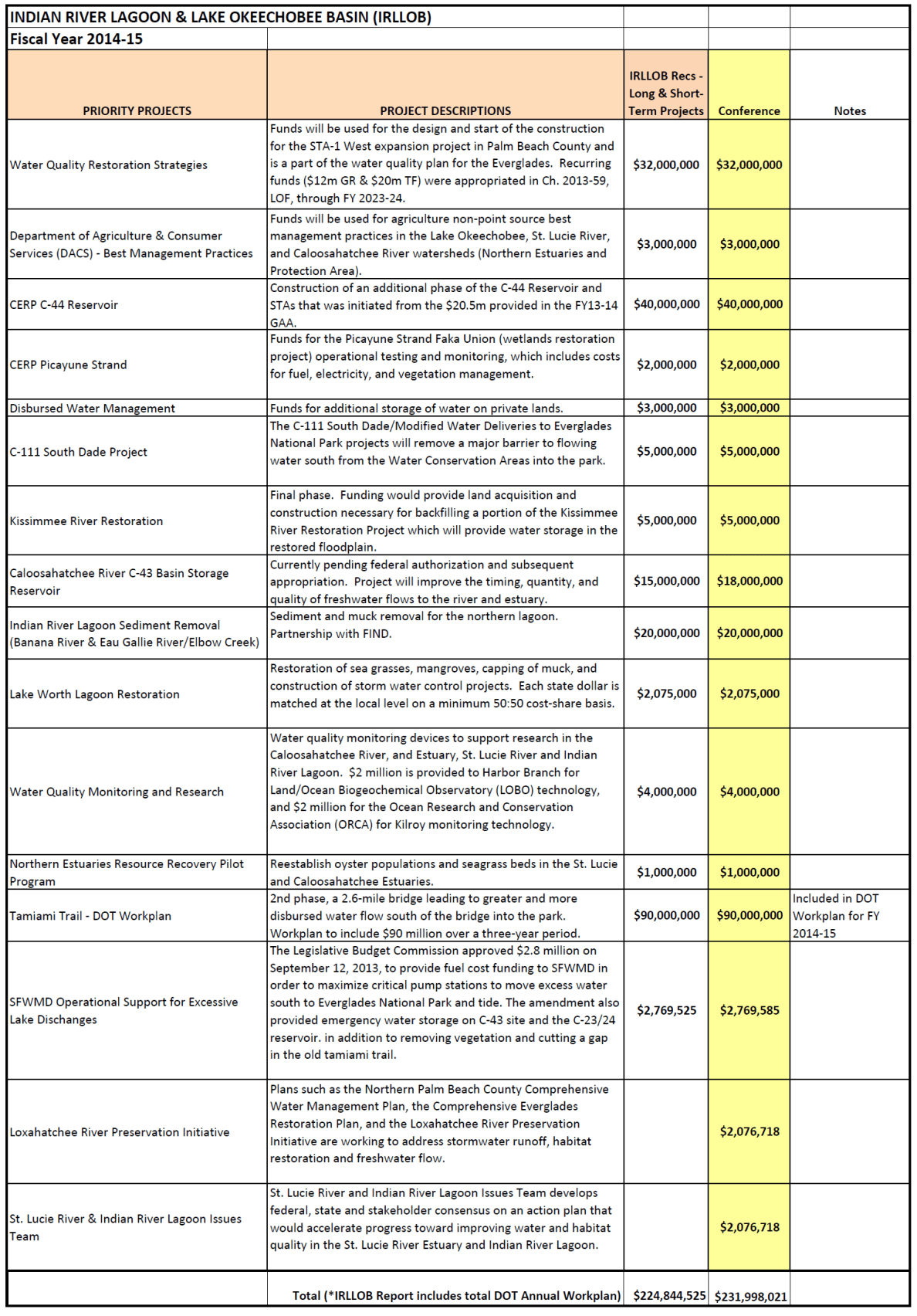
Senator Joe Negron, Senate Appropriations Chair, and leader of the “Senate Hearing on the Indian River Lagoon and Lake Okeechobee,” brought home more money for the IRL compared to any other water body in the state: $231,998,021. Our springs comrades who have been publicly fighting ten years longer than us, brought home 30 million. Tallahassee is wondering who this new kid on the block is, us….
Whether you are a fan or not, it must be noted that Senator Negron stuck his neck out, possibly compromising his senate presidency, to get our “name on the map” as far as Tallahassee goes. Prior to last year, most “good ‘ol boys in Tallahassee would have said, “Indian River Lagoon…Hmmmm? Creature of the Indian Lagoon, ain’t that a movie?”
Nonetheless, I do not pretend to think that these monies alone will cure the lagoon’s ills, as the gorilla in the room has not been addressed “head on and in its entirety:” the releases from Lake Okeechobee through S-308 and S-80. I believe this will come in time if we keep fighting.
In my opinion, the biggest part of change is the first step. With the outrage of the public over the “Lost Summer’s” toxic St Lucie River and Indian River Lagoon, and the support of Senator Negron, one of the few people in a the legislature with the seniority and status to act somewhat independently of demanding party pressures to conform, we have taken the first step forward to fixing the lagoon. Actually, a leap.
WE MUST CONTINUE, YES! But let’s be happy that we have made public progress on a state level more than ever before, and let’s look at what we received, as we should be aware of the gift of public monies from people all over our great state and be full of gratitude.
It’s a lot to go over, but it is important, so I will simply go down the list and summarize. Let’s look at the map as well. Please remember the SLR/IRL is part of the greater Everglades system, from the Kissimmee River area in Orlando, south to the Tamiami Trail in Dade, and beyond to Florida Bay. So anything done to help “the system,” helps us move water south, and with our health as well.
IRL/L.O. Fascility and Infrastructure Location Map Index, 2014. (Senator Negron’s Office)Key to stars/locations on map.
Here we go!
1. $32,000,000 for Water Quality storage in Storm Water Treatment Area 1 in Palm Beach County. Water storage is key to stop releasing so much into the estuaries.
2. $3,000,000 for Best Management Practices (BMPs) for farmers in the St Lucie, Lake O, and Caloosahatee watersheds. It is difficult to swallow more public money going to help farmers with pollution runoff, but there is no other way to do this. We must continue to help fund them, big or small. This is a historical issue as they have been here since the 1800s in many cases. I look at it like “grandfathering” with an extra requirement, as in real estate. The good news is that as time goes on, agriculture businesses will have higher standards to avoid pollution fertilizer, pesticides and fungicide runoff that is killing our waterbodies. Hopefully we can make changes before the rivers and springs die off completely.
3. $40,000,00 for the C-44 Storm Water Treatment Area/reservoir in Martin County. This will offset local drainage farm and urban runoff along the C-44 canal, not water from Lake Okeechobee. We must clean our local runoff as well as it is responsible for around 50% of the destruction to our estuary and on an everyday basis.
4. $2,000,000 CERP Picayune Strand east of Naples in Collier County. This area is important to the southern glades and needs monitoring and vegetative management for water flow and storage and improvement. Hopefully it will help some panthers too!
5. $5,000,000 C-111 South Dade. This is a crucial water delivery system to allow more water to “go south.” A must.
6. $5,000,000 Kissimmee River Restoration. The all time worst thing ever done in Florida other than dike Lake O and redirect the water to the estuaries, was to straighten the Kissimmee River. (Hold my tongue!) Restoration of the ox bows must continue. So far the ACOE has restored about 22 miles of the 56 miles of what was once 153 miles of gorgeous serpentine like, vegetative, wildlife filled, cleansing waters.
7. $18,000,000 C-43 STA along Caloosahatchee River. This is the equivalent of C-44 STA/reservoir for the Caloosahatchee. Only fair. C-43 is a must. They take up to three times the polluted runoff from Lake Okeechobee that we do!
8. $20,000,000 IRL muck removal in northern lagoon. The northern IRL has lost 60% of their seagrasses and has 2 Unexplained Mortality Events including manatee, dolphin, and pelican die offs. Give them what they need! Sediment/muck fills the lagoon over the years from canal runoff covering seagrasses; when stirred up, it releases legacy pollution. GET THE MUCK OUT!
9. $2,075,000 Lake Worth Lagoon. Lake Worth does not get the attention it needs being in development happy Palm Beach County. This area was once full of sea grass and life but not after years of receiving dump water from Lake O, like us, but through a different canal. Local advocate, Lee Shepard, is a great advocate for this part of the lagoon. Let’s help!
10. $4,000,000 Water Quality research for Harbor Branch and ORCA. Although it is hard to justify “more tests,” as we can all see the lagoon is dying, these new, scientific studies will help us find sources to our pollution issues that the legislature can’t ignore. Septic leakage, especially, is difficult to trace without such systems. LOBOS and Kilroys, please help us!
11. $1,000,000 Oyster recovery programs for St Lucie and Caloosahatchee Rivers. Millions of dollars worth of oysters, natural and deployed by government programs, died during the fresh water discharges of 2013 and years before. One oyster can filter 50 gallons of water a day. Government in action….
12. $90,000,000 NUMBER ONE NECESSITY is raising the Tamiami Trail in Dade County so water is not blocked off from going south. They should raise the whole road as the road built in the 1920s cuts off the flow of water south to the Everglades for the entire state. (Another environmental nightmare to fix.)
13, $2,7769,585 This money will be used for pump improvements etc to move more water south and cut away vegetation blocking water “going south,” or hold water in the C-43/44 reservoirs that would go into the estuaries.
14. $2,076,728 The Loxahatchee is one of two “Wild & Scenic Rivers” in the state of Florida and home to tremendous amounts of wildlife. Helping with storm water runoff and preservation is key for the health of this important part of the Everglades System.
15. $2,076,718 The St Lucie Rivers Issues Team has a long history of working with local governments for “close to home” projects along the SLR/IRL. Kathy LaMartina at its helm, South Florida Water Management District. Thank you!
Grand total= $231,998,021
I am grateful to the state legislature, especially Senator Negron, and I must note Governor Scott did not veto one line. But please know everyone, the “fight for right” along the Indian River Lagoon has just begun!
Parts of the Okeechobee Waterway or Cross State Canal, (partially C-44), is managed through a partnership of F.I.N.D.and the U.S. government, ACOE. (Photo Jacqui Thurlow-Lippisch, 2009.)
The Intracoastal and Okeechobee Waterways are important navigation channels and part of our country’s heritage.
Atlantic Intracoastal Waterway from Maine to South Floida. (Map, public.)
Okeechobee Waterway from Atlantic to Gulf of Mexico. (Map, public)
The history of navigation in the United States is a long one that is difficult to put into perspective within the context of today’s modern world. Military, commercial and communication centers were imperative goals to the newly established United States and remain so today, but these things are now taken for granted and have also inadvertently caused massive environmental destruction.
The Atlantic Intracoastal Waterway is a 3000 mile inland waterway along the east coast of the US from Maine to Florida. The Okeechobee Waterway is a few hundred miles across the state, from Stuart to Ft Meyers, linking the Atlantic to the Gulf of Mexico through canals and Lake Okeechobee.
These canals are directly supported by the public though a tax. If you look at your tax bill you will notice you are charged a .3045 mill to maintain the Florida Atlantic and Okeechobee Intracoastal Waterways. After a long evolution, today, the state’s Florida Inland Navigational District or FIND is the entity that acts in cooperation with the US Government, Army Corp of Engineers, to oversee these tax funds in order to maintain these important canals that serve many purposes. Some we don’t like…
One of the purposes of the Okeechobee Canal, built in the late 1920s and “improved” many times since, by being deepened and widened, is to release water from Lake Okeechobee into the St Lucie River/Indian River Lagoon when Lake Okeechobee gets too full, as the lake has been diked for the safety of agricultural lands and urban communities living around and south of the lake.
The mission of FIND is very broad actually; if we look at the mission statement of FIND it reads:
“The Florida Inland Navigation District has two primary missions: (1) to perform the functions of the “local sponsor” of the Atlantic Intracoastal Waterway project and a portion of the Okeechobee Waterway project in Florida, both of which are State/Federal navigation projects, and (2) provide assistance to other governments to develop waterway access and improvement projects. As the local sponsor of the Waterway, the District provides all lands required for the navigation project including rights of way and lands for the management of dredged materials removed from the waterway channel during dredging activities.”(http://aicw.org/index.jsp)
FIND is overseen by commissioners from the twelve counties along Florida’s east coast. Commissioners are appointed by the Governor and approved by the Senate. Our local commissioner is friendly and well known, Mr Don Cuozzo.
Don Cuozzo
FIND also serves other purposes very close to the people and local communities that I do care about, such as providing grant funding for local waterways improvements, and maintaining the important manatee signage and protection zones. We all know this iconic and endanger species, a gentle, distant relative of the elephant, is often stuck by speeding boaters.
Award winning photo seen in National Geographic story on south Florida waters, 2012.) (Photo by Paul Niklin, friend of Nichole Mader.)
Thank you to FIND, but it sure would be nice if we could FIND another way to for the lake’s water to go than through the St Lucie/Indian River Lagoon.
For 2013, Ed and I paid $13.31 to FIND. Although I would prefer not to support the Okeechobee Waterway atrocity, I do like manatees, boating, and the Town of Sewall’s Point has benefited from FIND grant programs as well. So, I guess, for now, Ed and I will pay the tax; but one day, I have the feeling, I might just rebel!
Girlfriends from the Martin County High School Class of 1982 celebrating our 50th birthdays in Sanibel/Captiva, the area of the Caloosahatchee River, Lee County, Florida.
This past weekend, my girlfriends from high school decided to travel across the state to celebrate our 50th birthdays!
It was a great time. We stayed in the area of the Caloosahatchee River which is the sister river the the St Lucie River. Both rivers have been plumbed to take overflow waters from Lake Okeechobee that Nature meant to flow south to the Everglades. The Caloosahatchee, in fact, is the “bigger sister,” in that when the rains come, she takes three to four times as much polluted, fresh water as we do—she is longer and larger than ourself. Ironically now, year long, the river needs constant small releases of fresh water from the lake as she becomes too saline. The system is suffering as is the St Lucie.
Caloosahatchee River was the first estuary to be channelized and connected to Lake Okeechobee in the late 1800s by Hamilton Disston. (Photo, CRCA)
“Caloosahtchee” means “river of the Calusa,” after the native peoples who lived and thrived there thousands of years ago.
So how does the Calooshatchee compare to the St Lucie? Well, according to the Caloosahatchee River Citizens Association, (CRCA), as sea levels receded after the last ice age, a series of lakes connected by wet prairies fed a tiny lake in the center of a valley feeding a “tortuously” long, crooked river that flowed slowly west to the Gulf of Mexico. So the Calooshatchee like the St Lucie drained to the sea but was never “connected” to Lake Okechobee.
But then entered “modern man.”
In 1881, investor and business man, Hamilton Disston, bought four million acres of Florida lands for development and agriculture getting the state out of debt. His first project was to drain the land around lake Okeechobee.
He dynamited the water fall between Lake Flirt and the Caloosahatchee and connected an old Indian passage from the Caloosahtchee to the lake. With that and the dredging and channeling of the mouth of the Kissimmee, the lake dropped tremendously, and although Disston committed suicide in a bathtub after the Panic of 1893, he inspired those following him to continue the drainage machine that has formed the Florida we know today.
After the floods and hurricanes of 1926 and 1928 the Caloosahatchee was straightened, deepened, and widened, draining surrounding agricultural lands and controlling flood waters. The “improvements” continued again in the the 1950s as more people moved into the area.
The story of the Calooshatchee is very similar to the St Lucie.
On another note, one of the most interesting parts of getting to the Caloosahatchee with my friends was driving “under” Lake Okeechobee taking Highways 441, to 80, to 27 and passing through the sugar towns of Belle Glade, South Bay, Clewiston and La Belle. It was a three and a half hour drive from Stuart to Captiva and most of the drive was through the Everglades Agricultural Area.
The Everglades Agricultural Area (EAA) is 700,000 acres south of Lake Okeechobee. To drive through them one drives just south of the lake.
As we were driving through we were amazed to think that historically the waters of Lake Okeechobee went south, as today, south of the lake, it is sugar fields for as far as the eye can see! And for many, many miles you are driving right next to the dike.
“This is kind of weird…”
Mile upon mile of sugar fields is the view while traveling south of the lake.Southern dike around Lake Okeechobee looks more like a hill of grass.
I reminded my friends of the hurricane of 1928 and the thousands of migrant workers that were killed with no alert of the coming doom. The small dike around the southern lake certainly did not look like it would hold if another monster storm came. We talked about how clueless we were as kids to the environmental effects of agriculture on our St Lucie River/Indian River Lagoon compared to what the children are learning today.
Of course we need agriculture but to have 700,000 acres completely cut off water flow south of the lake is an accident waiting to happen and a death sentence for our St Lucie Indian River Lagoon and for the Caloosahatchee.
As I talked about a possible third outlet to the lake, I told my friend Jill not to speed because if we were stopped, and I was in the car, we would all certainly go to jail!They laughed knowing I am an advocate for the St Lucie/Indian River Lagoon an often contentious issue when it comes to sugar farming.
Once in Captiva, we had a great time, paddle boarding, riding bicycles, swimming, and going out in Sanibel/Captiva Island.
Such a wonderful time would not have been possible had the Army Corp and South Florida Water Management District been releasing masses of polluted, fresh water from Lake Okeechobee. United we are on both sides of the state, that there has to be another option for Lake Okeechobee’s water coming through our estuaries–we are sisters!
A beautiful sunset over the convergence of Pine Island Sound and the Caloosahatchee , our sister river.
The delay of CEPP, the Central Everglades Planning Project, may end up symbolically being the beginning of Florida’s 4th Seminole War as people fight for water to move south. (Photos public.)
I really did not want to write about the failure of the Central Everglades Planning Project, CEPP, as I have been trying to forget about it. The whole thing is so depressing to me. However, last night, before I went to bed, my husband said, “Dan thinks you should write about what’s going to happen now that CEPP did not make it into the WRDA bill…” So, I had a long series of nightmares, now it’s morning, and for Dr Daniel Velinsky, I will do the right thing, and try to write this piece.
First some history.
It is well documented that Florida’s three Seminole Wars were the longest, bloodiest, and most costly of all the Indian wars fought by the United States, fought on and off between 1814 and 1858. In the end, no treaty was signed and the few hundred remaining native peoples hid in their well known Everglades swamp to resurrect themselves as today’s Seminole, Miccosukee, and unaffiliated Independent Seminole Tribes.
They never surrendered and today their successful 1980s/1990s law suit against the Federal Government and the State of Florida requiring the polluting of Everglades Agricultural Area run off water onto their lands, to be reduced from sometimes over 300 to 10 parts per billion/phosphorus, in my opinion, is a key reason, along with its tartiness and other issues, why CEPP was not included in the Water Resources Development Act, WRDA, bill by the U.S. Army Corp of Engineers.
I can hear the D.C. ACOE now: “Even if we had the designated land, the mass of water could not be sent south—it’s too dirty. We need so much more land to clean it. So we’ll build all this structure but we won’t be able to send but a dribble of water south…Florida has to lessen the water quality requirements or …”
Well first of all, I say “kudos” to the Seminole and Miccosucci for holding the state responsible for cleaning up its water, even if it is an”impossible” number to achieve under present circumstances. I’d say in the karma department, “we had it coming.”
So now what do we do? Well in my opinion a type of war is going to start, and I liken the people of the St Lucie River/Indian River Lagoon to the “Fourth Indian War Warriors.” We will not surrender.
The failure of CEPP to pass will historically be the beginning of this war. And like the Indians of the 1880s, we were indirectly lied to, and part of it was our fault for believing what we were told, knowing the facts of history.
We all watched and participated along with the South Florida Water Management District and the Jacksonville Army Corp of Engineers for three years, putting full concentration of resources and creativity– forcing dedicated staff from both agencies to produce a document, CEPP, that the US Army Corp of Engineers more than likely knew, would never make it. So now, “they” want us to continue rallying for another two years for next WRDA bill. “Oh sorry maybe it will be seven years….”
I don’t think so.
Guess what? The people are tired of waiting. They put their money on the state and federal governments’ horse, and our horse wasn’t even allowed to run.
Do you feel the chain pulling and digging into your neck? I do.
This tactic is not new, and honestly I think it is simply part of a dysfunctional federal and state government. Let’s look back.
In the 1990s governor Lawton Childs had the state halt the famous water quality law suit and actually “laid down his sword” in a courtroom-how courageous, but look where we are now; in the mid 2000s Charlie Christ’s “Sugar Land Deal” was downsized due to the Economic Crisis of 2008 and other politics; before that, Jeb Bush started the “Acceler8 Program to quickly complete eight of over 60 Central Everglades Restoration Plan’s (CERP) projects. The SFWMD, functioning under the governor, worked diligently like they did recently for CEPP–the eight projects were not completed; and since 2011/12, under the Rick Scott administration, the entire focus was on CEPP, which also would have bundled some of the CERP projects to begin “moving faster” and to “move the water south.” After years of laser like dedication, for now, the project is “dead.”
Florida has water quality and quantity issues brewing like a hurricane, and our Indian River Lagoon area will be the eye in November of 2014, as former governor Charlie Christ runs against Governor Rick Scott. The race would have been messy anyway, but now it is going to be war as the different sides configure how to “send the water south” with out CEPP. Start thinking about how you want to send the water south or stored, and “never, never, never give up.”
“End of the Rainbow,” South Florida. (Photo by John Whiticar, 2013.)
As we approach hurricane season, we must prepare for rain. Florida is more like Africa than the rest of the county in that there are really only two seasons: dry and rainy. “Officially,” rainy season runs from June 1st to November 30th, and dry season is from December 1st through the end of May.
One of the most interesting accounts I’ve ever read of a “great south Florida rain” was published in 1886 by pioneer Charles Pierce, member the famous Hannibal Pierce family, to which our illustrious Indian Riverkeeper, Mr Marty Baum belongs. We along the St Lucie/Indian River Lagoon are part of the south Florida great rain system and there are reoccurring themes whether here or farther south, as l think you’ll see as I share the story.
Charles Pierce is most well known for his book “Pioneer Life in Southeast Florida” written about the years 1870 through 1894, and published by Miami’s University Press in 1970. It is a five star classic. According to a write up on the book, during this era of Florida history around 724 people were living between Stuart and Miami.
My mother, historian Sandra Thurlow, shared an excerpt that Charles Pierce wrote for the Broward Legacy in 1886, as he was living and overseeing the Biscayne House of Refuge at the time.
According to Pierce:
“In October of 1884 occurred the greatest and longest rainfall ever known on the east coast since its earliest settlement. It poured down for eight days and nights, slacking at times for a few minutes, but never stoping; then came down harder if that were possible. The whole southern part of the state was inundated…
On the eighth day the rain stopped and the next day came in bright and clear, and the sun shone brightly on a rain-soaked Florida…
I was on the east porch looking out to sea…looking up the coast to the northward, I caught the glint of something white about four miles away. At first, I thought it was a sea gull, then it looked like striking fish. I was not certain which it was, so I went for the old long spyglass to get a close up view of the scintillating white. What the spyglass revealed surprised me. The flickering white I had seen was now clearly shown to be whitecaps or breaking seas at the head of a dark body of water rushing down the coast….a mass of dark water some hundred feet in width rushing along to the south and with breaking seas over running the blue water in front.
It was a strange sight and at first we all wondered where it came from. My father Hannibal solved they mystery when he said, ‘It is fresh water from the New River Inlet.’ Could that be possible? It was fourteen miles away but there was no other solution to the phenomenon.
What a mighty volume of water must be coming out of the inlet and with tremendous velocity enough to overcome the resistance of wind and sea for so many miles. By night of that day the entire ocean in sight of the Station was covered with dark coffee-colored freshwater from the New River. Not a bit of blue water to be seen in any direction. Biscayne Bay was fresh for nearly a month after the week of rain.”
Incredible. So even before humankind diked and channelized the entirety of south Florida, when it rained heavily, the black wave of fresh water pushed forth through the south eastern inlets to the ocean; it did not just “go south.” We see a similar but not as intense phenomenon today, although drainage has been modified, when a heavy rain gushes through the St Lucie Inlet, Ft Pierce or Jupiter Inlets. In any case, when one hears a story such as Mr Pierce’s it makes one wonder, with all that water, during a really “great rain” a rain that comes only once in a few hundred years, will our manmade structures hold?
We all know the Army Corp of Engineers, along with support from the South Florida Water Management District, is working diligently to harden the dike around Lake Okeechobee, but it seems that a third outlet, a flow way south, from the lake to the Everglades surely would alleviate some of that natural pressure, the pressure Charlie Pierce describes as a
“tremendous velocity…”
If he were alive today, I wonder what Mr Charles Pierce would think?
Army Corp of Engineers’ structure S-80 releases water from Lake Okeechobee into the the C-44 Canal that leads to the St Lucie River/S. Indian River Lagoon. (Photo Jacqui Thurlow-Lippisch, 2013.)
Today is what I consider the genesis of the Martin and St Lucie River movement, as last year, on this day, May 8th, 2013, the Army Corp of Engineers opened the gates of S-80 once again, but little did they know, this time things would never be the same….
Before we laud ourselves too much it is important to know our history and its not a fun one to study. Martin County and the C-44 Canal have a long history, in fact the canal, started in 1915 precedes Martin becoming a county which occurred in 1925. The City of Stuart though was incorporated in 1914, and it was their early leaders that supported the the building the C-44 canal.
Ironically most the early settlers wanted it, having no idea of its unintended consequences, and in 1915 even held a celebration when construction began by featuring the high school band and a gathering at Woodmen Hall in downtown Stuart.
According to historian Sandra Thurlow’s book Stuart on the St Lucie:
“The Stuart Times pleaded for a canal in its early issues in 1913. The Stuart Commercial Club pushed for the canal and clashed with BW Mulford and and other promoters of Salerno who insisted that the best route for the proposed ship and drainage canal from Lake Okeechobee would be one cut into the Manatee Pocket.”
The canal was an economic issue and people wanted jobs and trade brought to the area.
After the Hurricane of 1928 the canal was widened and deepened, and the situation really got worse. “Silt and chemicals entered the St Lucie/Indian River and diminished the once teeming fish population.” Again according to Sandra Thurlow, “because the the changes were gradual it took a while to notice that the abundance that had nourished the settlers and attracted the sports fishermen no longer existed.”
Hard to believe isn’t it? I have had some people tell me, “It’s better not to bring this up….” I disagree. Times change and values change. Our country is known for overcoming some of the most difficult of institutions such as slavery and women’s rights. Environmentalism is also a social issue. It is based on how one views the world, what is acceptable or not.
Today most Stuart and Martin/StLucie residents agree that it is no longer acceptable to have up to 9000 cubic feet per second of dirty, tainted Lake Okeechobee water released into our St Lucie River. In 2013 the releases from Lake Okeechobee tipped the scale for toxic algae blooms in the estuary, (FOS, Mark Perry). And it was well known from sampling that the South Florida Water Management District (SFWMD) knew toxic algae was being released into the estuary at S-80.
In the early 1900 and even through the 1970s, not that many many people lived in Martin County. Having grown up here, I can attest to that. But, that is not the case today. Releases that were simply “accepted” are now “unacceptable.” Unlike years ago, with today’s high population and health and safety issues that are the responsibility of the state, the releasing of toxic waters from outside our basin is an embarrassment and seems illegal.
1930 was the first year the Martin County Commission asked the ACOE to stop discharging and passionate people have been demanding such ever since. But at that time, there were not enough people to really have a voice and the general public was not screaming along side its leaders. Today we are are all on one page. Local elected officials and the public. And we also have tools that allow us to make our cause a state and national issue.
If history has shown anything at all it is that things do change. I believe we are the generation that is in the right place at the right time to finally cause the turn of history for the St Lucie River/Indian River Lagoon. Happy May 8th, 2014!
A portion of the restored Kissimmee River. Note discolored and filled C-38 canal juxtaposed to winding restored, greener oxbows. (Photo Jacqui Thurlow-Lippisch, 2014).
Last week, on a hazy smoked filled afternoon, Ed and I flew over Lake Okeechobee and the once mighty Kissimmee River. There was the normal stress involved with me giving Ed directions and the fun of an adventure. It went something like this:
“Oh there it is, the Kissimmee’s opening to the lake, over there!”
I can’t fly north of “over there,” it’s off limits; it’s a near a bombing range or air force base…” says Ed, shooting me a serious glance.
“What a bombing range-air force base? You’re kidding, close to of some of the state’s richest wildlife habitat? How symbolic…”
Ed rolls his eyes, I can feel it. But he tries harder…
Somehow, Ed talks to Miami Air Traffic Conrol and we get lucky. It is a Sunday and we are allowed to fly over at least part of the area I wish to see.
On the way, we fly over the southwest area of the lake’s agricultural lands. The hand of humankind is reflected in organized, perfect sized boxes of agriculture and straight canals.
We veer off to the northwestern area of the Lake Okeechobee where earth and water meet; on this side of the lake the hand of the Creator still evident. Little specks of light blend together in a blinding symphony of light.
We near the area in Okeechobee County where the mouth of the once great Kissimmee meets Lake Okeechobee. The straightened canal looks out of place among the lush greenery and a small town is evident. There are people here. Flooding is an issue.
It is great seeing “it all” from above as I have never really been able to figure out on a map where the Kissimmee River restoration is happening. It starts about 20 miles north of the lake.
The Kissimmee river was once 103 miles of wildlife/fish filled meandering oxbows, but it was canalized to a depth of 30 feet as C-38 from 1962-71. This was part of the Army Corp of Engineers and the Central and South Florida “Flood Control Project” of 1954. The state had asked for help after two back to back hurricanes and wide spread flooding and destruction in 1945. The state got help but with untended consequences…
The Kissimmee River that once meandered south to Lake Okeechobee as part of a two mile wide flood plane now shot down to the lake with grave environmental effects that included the destruction of the estuaries, St Lucie/Indian River Lagoon and Caloosahatechee.
Since 1994, around 23 miles of the now 56 mile long canal, C-38, from Lake Kissimmee to Lake Okeechobee has been/is being backfilled and considered part of “the” most ambitious environmental restoration project in the world.
Recently, the ACOE and SFWMD have been in a dispute over the completion of the restoration project. The project is tremendously expensive requiring federal and state funding which has not come easy since 2008. The two agencies “cost share” in its completion. Word is they are “working things out…”
The long term goal is to continue the restoration of at least 20 miles more of the 56 miles of the canal.
In light of the dying Indian River Lagoon, it is important to see that restoration can be accomplished. Mother Nature is quick to rebound once given the chance.
The Kissimmee’s restoration is critical, as the polluted waters coming from Orlando south carry sediment, and urban and agricultural runoff into the lake. As we know, when the lake gets too full the water is diverted to the estuaries because the water is not presently allowed to flow south, as the EAA (Everglades Agricultural Area) is located there along with cities of people.
So we here along the St Lucie Indian River Lagoon, are fighting a two front war. One north and the other south of the lake. We are winning in the north because the ACOE and SFWMD recognized their/our mistakes, and have been working since 1994. We are also getting closer in the to finding a safe way to “move the water south…” CEPP (Central Everglades Planning Project) is not looking good right now, but the pressure is on, and even Tallahassee is saying “move the water south!”
We must have inspiration or we will never complete our goal of saving the estuaries. The Kissimmee River is a place to look and find hope.
2014 Google Earth map of restored area of Kissimmee River.
Canals C-23, C-24 and C-25 in St Lucie County were built in the 50s and 60s and are all connected. C-23 and C-24 release into the north fork of the St Lucie River leading to the S. Indian River Lagoon, but C-25 releases straight into the southern central Indian River Lagoon near Taylor Creek, close to the Fort Pierce Inlet. These canals were built as part of the Central and South Florida Project of the 1940s that came into existence after a very large flood of central and south Florida. (Photo, Jacqui Thurlow Lippisch, 2013)
One of the things that is hardest for me to comprehend is that my ancestors worked as hard, if not harder, to get the water off the land as I am, trying to keep in on…
According to an article shared by my mother, historian Sandra Thurlow, by Charles S. Miley a newspaper man in Ft Pierce, “prior to the 1920s floods were a common occurrence in the area particularly in the back-coutry.”
The article discusses how a demand for drainage began to develop among land owners as the growing of pineapples was no longer profitable and the people turned to citrus. In 1915 citizens in the area of Ft Pierce “held court” forming the North St Lucie River Drainage District. The headline in the News Tribune paper of 1921 read: ” Drainage of 75,000 Ares of Rich Land Now Under Way.”
I can just see it, “Sam, I think it’s time to form a flood district and utilize our lands.” Go forward just shy of 100 years and the conversation is : “Joe, I think it’s time we get the Army Corp to stop dumping this lousy water into the St Lucie River, ruining my riverfront property values.”
The North St Lucie River Water Control District is still in place today and was created, as all drainage districts of its time, under the provisions of Chapter 298, Florida Statutes, commonly referred to as the “General Drainage Law of Florida.” Today the NSLRWCD falls under the authority of the South Florida Water Management District that historically began really as the Central and South Florida Project, C&SFP.
In 1945 there was massive flooding throughout central and south Florida so the state and its residents called for federal assistance. Sound familiar? It may if you recall that the Hurricane of 1928 caused an even more extreme reaction and the Herbert Hoover Dike was built around Lake Okeechobee by the Army Corp of Engineers. Thus our federal partnerships today. The one that we complain about all the time…Ironic, isn’t it?
The green area is the NSLRWCD’s boundaries; the orange are is the Fort Pierce Farms Drainage District, since 1976 under the South Florida Water Management District.
So, I drifted a bit, but I was talking about the Central and South Florida Project. This large project was formed after the great flood of the 1940s and three huge canals were built during the 50s and 60s as part of this plan: C-23, C-24 and C-25. I drove over them for years with my parents as a kid and had no idea what they really were, I never learned about them in school, and I was 40 years old before I decided I needed to figure them out…
Map of canals system, Matin/St Lucie Counties.
I have not even mentioned the C-44 also known as the “St Lucie Canal” that is further south. This canal drains the basin lands around it as well as being a dumping ground for “overflow waters” of Lake Okeechobee.
The South Florida Water Management’s web site says that after C-23, and C-24 were built, the north fork of the St Lucie River drained lands approximately four times its natural drainage size! That is not even counting C-44 and Lake Okeechobee. Oh, and by the way in 1892 we opened the St Lucie Inlet permanently too.
We are living a world very different than Mother Nature created. From what I’m told she’s moody and a bit irritated. I think I’ll keep working on getting her some of her water back!
Last year, people rose up giving the Indian River Lagoon her voice. Tallahassee has heard. (Drawing of Earth, people and waters by River Kidz member, Mary Thurlow, age 11.)
“Let us throw off everything that hinders, and run with perseverance, the race marked out for us…” Hebrews
We might still be a long way from the finish line, but no one can say that the Indian River Lagoon hasn’t hasn’t been “heard.” In 2012, few state legislators, not even the Governor, sitting in his chair in Tallahassee knew what, or even where, the St Lucie River/Indian River Lagoon was… Today literally, “everyone” in Tallahassee knows about the, dying manatees, sick dolphins, toxic waters, the disappearing seagrasses, and deadly releases from Lake Okeechobee. On top of that “Tally” is watching the IRL positioned to walk away with a large chunk of the pie, a pie that others wanted too. Others who had been fighting longer than the IRL and were very much know by name… Remarkable.
(Specifics of Negron’s Senate/House negotiated IRL/L.O. 3-year budget for 231.9 million dollars. This “recommendation” must still go before the Governor’s pen.)
How did this happen? How did the Indian River Lagoon get so well known so quickly?
This happened because the the people, River Kidz, and local officials of Stuart, Port St Lucie, eventually all eight counties along the lagoon, rose up, demanded change, exposed health, safety, and moral issues, and then the local press, Scripps, took that flame of the people, threw kerosine on it, and has continued to keep the fire going. State and Congressional politicians along with state and federal agencies, usually free to do whatever they pleased, were taken off guard, suddenly their constituency was watching where officials got their money, how they were voting, and if they were supporting the lagoon.
Senator Joe Negron listened and made the Indian River Lagoon his first priority creating the budget list above, held a Senate Hearing that took the topic “viral,” possibly under-cutting his Senate presidency because of his outspoken support, and then proceeded to tell the ACOE they needed to give up their control of the lake and that they were “killing us;” Rep. Gayle Harrell made a memorial in DC her “top”priority; newcomer Rep. Larry Lee voted against party line for the sake of the lagoon; and freshman Rep. Mary Lynn Magar passed out bottles of muck ridden toxic river water and aerial photo booklets to her colleagues, Rep. Debbie Mayfield called her closest contacts… At the federal level, Congressman Patrick Murphy did every single thing possible to familiarize the ACOE leaders with the C-44 IRL project, and even invited the public to DC for a special meeting. In walks Nancy Pelosi, and then this bipartisan group helps get the WRDA (Water Resources Development Act) bill passed in the US House of Representatives where usually people can’t make a decision to save their lives. Holy Cow!
OK, let’s pull back for a moment, because I come from a group of erudite and very skeptical river supporters. And although I am excited, I am not wearing rose colored glasses and never have. I know politicians can dance like marionettes when they need to; I know that a lot more has to be done, like a flow way south; I know that if it starts raining intensely tomorrow and doesn’t stop, a repeat of the “Lost Summer” will happen all over again. But Karl…Michael….the others….even you, the harshest, most honest critics, have to admit that the end of 2013, and so far 2014, has been one remarkable year. Less than a year actually…
Just May 8th of last year, the releases from Lake Okeechobee began releasing for 5 months, and set off a series of events that galvanized public outcry. Thousands of people rallied at the locks and shoreline; social media whipped the situation to a frenzy, and today we are still today talking about it, fighting for it, and defining ourselves and our children by it. There are no social, age or economic boundaries. It is all of us. We are making history.
Yes, a great disappointment, the ACOE’s recent denial of CEPP (Central Everglades Planning Project) into the WRDA Bill last week is a huge setback, but the Army Corp of Engineers has forgotten something. When passions are repressed, they only get stronger.
This Saturday at 9 AM, locals have organized a “Funeral Services for the Lagoon” at St Lucie Locks and Dam in response to the ACOE’s inaction. (Go to Facebook for information.) Here again locals will plead their case to “send the water south.”
When I reminisce about the past year and even present, I am reminded of Dr Suess’ famous children’s book, Horton Hears a Who. The story is about the miniature city of people who live on the speck of dust. After being lost, Horton the elephant and the other animals hear the screaming “We’re here!” “We’re here!” of the tiny people of Who-ville, and agree to protect them. But they wouldn’t have protected them if they did not hear them. Remember?
Like the story, the Indian River Lagoon has finally been heard! Be proud of this. It is a huge accomplishment. We are certainly not yet at the finish line, but let’s be happy that 2013/14 has been, “The Year of the Indian River Lagoon,” and that everyone knows our name!
1950s map of Hutchinson Island’s “Coral Strand.” Today, known as “Sailfish Point.” (Map, Ben McCoy, courtesy historic archives of Sandra Henderson Thurlow.)
How romantic, the “Coral Strand…” Like a string of pearls the riches of Hutchinson Island’s coast strung along the blue waters of the Atlantic and Indian River Lagoon. The crowing jewel, today, known as Sailfish Point.
The above promotional map by Ben McCoy, brother, of the infamous rum runner, Captain Bill McCoy, highlights some of our area’s best features, most interesting history, and even an excerpt from a novel by Faith Baldwin:
” It was a long jut of land running into the water, upon one side was the ocean, upon the other, an inlet forming a small quiet bay. It was colored like a lithograph, strong blinding colors. The beach was so white that it dazzled, water and sky so blue they seemed unreal…”
If one looks closely at the map, fish of the area are listed around the point: Blue Fish; Sheepshead; Bass; Snapper; Pompano; Spanish Mackerel; and Tarpon everywhere…the Indian River is not noted just as the” Indian River” but the “Famous Indian River,” for fishing of course!
The publication notes that five presidents, Arthur, Cleveland, Roosevelt, Taft, and Harding, as well as Joe Jefferson, beloved disciple of Izaak Walton, fished these waters as “who indeed among fisherman has not heard of the famous St Lucie Region, rendezvous for more than half a century for anglers from all over the world!”
Believe it or not, according to The History of Martin County, the McCoy’s land, today’s Sailfish Point, was listed for $25,000.
It is fun to visit the dream like past, but soon or later, reality always sets in. In the 1950s the Coral Strand was sold to eccentric entrepreneur and Florida Oceanographic Society founder, James Rand, for its limited development the name was marketed as “Seminole Shores.” Later in the 1960s, the the Hutchinson Island property was sold by Harvard University to a group of Boston investors and eventually to Mobil Oil who legally tore the mangroves from the land, scared off the mosquitoes and filled it. Eventually, in the 80s the land was developed as exclusive “Sailfish Point.”
According to Dr Grant Gilmore, most famous for his long career at Harbor Branch Oceanographic, the waters/seagrasses surrounding Sailfish Point, the old Coral Strand, are truly the most diverse in the North America with over 800 types of fish, often growing baby fish, documented in these waters.
It is a crime that during rainy season, the Army Corp of Engineers often releases water from Lake Okeechobee exacerbating the pollution from our local canals killing the seagrasses in these waters, thus fish habitat destroyed. Last year, in 2013, according to Mark Perry of Florida Oceanographic, approximately 85% of the seagrasses were destroyed.
Yes, this has happened many times, but one day, it may not come back.
For history, for today, we must fight to protect our “Coral Strand,” and our pearl, our incredibly bio-diverse waters…
Clear beautiful water off the Sandbar, Stuart; but is safe to swim? (Photo, Jacqui Thurlow-Lippisch, St Lucie River/Indian River Lagoon, 2012)
Enterococcus: Bacteria normally found in the feces. Two types, Enterococcus fecalis and Enterococcus fecium, cause human disease, most commonly in the form of urinary tract and wound infections. Other infections, including those of the blood stream (bacteremia), heart valves (endocarditis), and the brain (meningitis) can occur in severely ill patients in hospitals. Enterococci also often colonize open wounds and skin ulcers, and are among the most common antibiotic-resistant bacteria. Medicine-Net
*The Martin County Health Department tests for Enterococcus (E) in area waters: According to their interpretation, 0-35 cfu of E./100 ml river water =GOOD; 36-104 cfu E/100 ml river water=MODERATE; and 105 cfu E./ml River water is POOR (“cfu” relates to number of viable cells per milliliter.)
In November 2012, some members of the public were worried that the Martin County Health Department (MCHD) did not have enough support. Due to the pushing of a few members at a Rivers Coalition meeting, Senator Joe Negron, during the legislative budgeting process, added specific funding for MCHD to sample three new sites weekly. In turn, with input from the Rivers Coalition and the help of Bob Washam of the MCHD, the three test locations were chosen and the public began regularly checking bacteria levels in the St Lucie River/Indian River Lagoon on the MCHD website.
Before the senator intervened, the sites being tested in the river were the Roosevelt Bridge; the Jensen and Stuart Causeways, and the north fork of the St Lucie River in St Lucie County.
The new test sites included Bessey Creek, close to the mouth of the C-23 canal, in Palm City; Leighton Park, at the base of the Palm City Bridge; and Sandsprit Park, near the Manatee Pocket in Stuart, close to the inlet. The Department of Environmental Protection also conducted/s periodic testing.
In early June of the 2013, the bacteria numbers really spiked. This occurred after heavy rains caused storm water to run through local canals C-23, C-24, and C-44 into the river, as well as polluted fresh water discharges from Lake Okeechobee through C-44, that had begun on May 8, 2013 by the Army Corp of Engineers.
The areas waters were looking dark and ugly, and most of the river was off limits to the public due to high Enterococcus levels. By mid June, there were a number of reports from people that had visited the Sandbar, located just inside the mouth of the St Lucie Inlet, that they and their children were feeling ill with stomach aches and diarrhea after contact with the water.
(Photo of water in St Lucie River two miles from Sandbar w/ high bacteria and toxic blue green algae, photo by Jenny Flaugh, July 2013.)
Because of the popularity of the Sandbar area and the complaints to the health department, Bob Washam, MCHD, together with Mark Perry, of Florida Oceanograpic, decided to drop the Bessey Creek site and change testing to the Stuart Sandbar. When the tests came back, the Sandbar reading was a high 192 cfu/100 ml river water/or POOR. So signs were posted at the Sandbar, at the hight of the summer season; it was off limits to the public. Shocking.
Just for comparison, I am going to share the highest readings at the other sites in June and July of 2013. The highest readings were as follows: Roosevelt, 1620 cfu; Sandsprit, 640 cfu; Leighton, 3020 cfu; and Bessey Creek, 1560 cfu. As mentioned about 105 cfu per 100 ml of river water is considered POOR.
For a comparison to “today,” the latest readings on April 21, 2014 were: Roosevelt, 58 cfu; Sandsprit, 7cfu ; Leighton Park, 94 cfu and the Sandbar, 30 cfu . So even without super heavy rains or releases from Lake Okeechobee, readings can be moderate to borderline poor. (The Leighton site had been in the poor range just a few just weeks ago but is coming down…)
It is important to know that bacteria levels are absolutely exacerbated by the releases from Lake Okeechobee that bring in polluted fresh water from outside of our basin as far away as from Orlando, but Lake Okeechobee is not the only cause. Local canals’ runoff, poorly cared for septic tanks, farm and domestic animals, along with other sources in both Marin and St Lucie Counties, even Okeechobee, anywhere water runs into our rivers from a basin, play an important role in the bacteria water puzzle.
To understand the sources of fecal pollution, Martin County is presently conducting a water quality monitering study in partnership with Florida Atlantic University’s Harbor Branch. The study is tracking DNA results leading “back,” through attachment to isotopes, to either human, cow, horse, dog and/or bird feces.
At this point, studies are inconclusive, and helpful data is not expected until rainy season begins June 1st through November 30th.
We can’t dream that things here in Stuart used to be “perfect.” When I was a kid growing up in Martin County in the 60s and 70s there were some businesses that legally dumped their raw sewage into the St Lucie River and boaters were allowed to dump waste straight into the river. There were fewer people here then, yes, but it is still disgusting by today’s standards. I grew up swimming and water skiing in these waters. I never got sick and back then no one was monitoring the bacteria in the river
In conclusion, we don’t need to panic, we just need to be careful, and to be thankful for the progress we have made; most important, we must continue to improve the situation and “fix it.”
______________________________
Thank you to Bob Washam, formerly of the MCHD, for his years of dedication and for his help with composing specifics of this article.
Topographical map of EAA showing elevations. CEPP would move approximately 15% of Lake Okeechobee’s overflow water south and build a basis for future increases, rather than sending all water through the northern estuaries. By means of canals in the EAA and other structures, this water would be cleaned and then directed to the Everglades. The ACOE refused to sign off on CEPP 4/22/14. (Map courtesy of INTER-MAP via Kevin Henderson)
CEPP=Central Everglades Planning Project, 2014,( contains elements of CERP); CERP=Comprehensive Everglades Restoration Plan of 2000.
To every action, there is a reaction, and in the case of the ACOE refusing to sign off on CEPP, the reaction here in Martin, St Lucie, and Lee County across the state certainly will not be “good.”
Mind you there is a Jacksonville ACOE, who works with “us” and then the ACOE in DC. They are the same but different…
Let’s start at somewhat of the beginning so we can get a grip on this always terribly confusing, multi-layered attempt to fix our estuaries and restore the Everglades.
Around 2000, long before I was involved with the River Movement directly, a group of Florida stakeholders, including environmentalists, the agriculture industry, tribes, utilities, users, and government agencies miraculously agreed on something called CERP, or the Comprehensive Everglades Restoration Plan. This plan consisted of at least 68 projects to “fix the Everglades.” It was historical and celebrated by all. Congress approved and eventually appropriated some funds that would be shared in costs with the South Florida Water Management District, (SFWMD) towards “CERP.”
Now, 14 years later, some work has been done, but not one of the 68 projects has been completed.
OK now we move to 2010, 2011… still in the sinkhole of 2008 Great Recession, the SFWMD, the local ACOE Jacksonville team, and the stakeholders decide sitting with “nothing” is not an option and determine to do something unprecedented and “speed things up.” They work like crazy, often being criticized by those same stakeholders, to package some of the CERP ideas into CEPP (the Central Everglades Planning Project) to sell to the DC ACOE and Congress again, in a different form, and get things going.
Although often behind, the Jacksonville ACOE appears to almost meet their deadline of 18 months and finally, two weeks ago the SFWMD is able to sign off on cost sharing (not an easy task and not all supported the move) on the local Jacksonville ACOE completed CEPP project— which of course has to meet every Tom, Dick and Harry regulation you can possibly imagine. A neurotic situation for sure.
So yesterday, Earth Day, the Washington D.C. ACOE office refuses to sign off on CEPP, saying they need more time to review the documents they have had since last August.
As of yet, no official statement has been given, but the local press and the Everglades Foundation’s Eric Eichenberg call the move “a staggering failure of duty and responsibility.” I would imagine the main concern here is that the Water Resources Development Bill (WRDA) that only comes around once every 5-7 years these days, must include CEPP for it to be funded (appropriated) by Congress. Now it seems CEPP will certainly not make the deadline, which is really “now.”
So is there hope? We all know, that “it’s not over until its over,” and until the WRDA is officially closed, perhaps some political miracle could ensue. Is it likely? I would doubt it. But I do not know.
What I do know is that Florida has been really dependent on the Federal Government since 1933 when the Florida Legislature and the people of Florida convinced the US Government to build the Herbert Hoover Dike around Lake Okeechobee and the ensuing flood control projects over the years to protect the important growing agriculture industry south of the lake and thousands of people who were allowed to build and develop inside the Everglades’ historical flow area, especially south from Palm Beach to Dade counties. At this time there was no thought of the estuaries.
So in many ways we want our cake and to eat it too….”protect us from the waters of Lake O but don’t hurt the estuaries….” Something is going to have to give.
For almost four years, Senator Joe Negron has been pushing for less involvement of the ACOE. Whether one likes Senator Negron or not, I agree with his philosophy. Congress/ the US ACOE is no longer supporting the dredging of our state inlets which they did for almost 100 years, and they most likely not going to support the restoration of the Everglades and the betterment of the estuaries through changing our pluming system and sending more water south. After 14 years of of begging, and celebrating crumbs, you’d think we’d get the message.
Is this the Jacksonville local ACOE’s fault? Not really as the Federal Government is simply terribly dysfunctional so it is hard for the ACOE to do its job, plus they are broke.
In conclusion, yes, we have to finish what’s been started, and I recognize the difficulty of “us” fixing our own problems, however; if we really take a hard look in the mirror, there may not be a choice but to try.
Congressman Patrick Murphy speaking, Kiwanis luncheon, 4/15/14, 2014. (Photo by Jacqui Thurlow-Lippsich)
One of the nicest things lately is spending time with my father. He is a long time member of Kiwanis and has invited me to be a guest three times this year. Yesterday, he invited me because Congressman Murphy was speaking, and my dad knows I like politics, especially “river politics,” of which Congressman Murphy has been very supportive.
In the relatively small group I had the opportunity to ask a direct question. One thing I am very aware of is that even though I study this water “stuff” all the time, I literally understand the only “tip of the iceberg.” This is confusing and I know if I don’t know, there are plenty of others who don’t know either.
So today, I am going to try to explain what I think I know, and what Congressman Murphy explained yesterday about the Water Resources Development Act (WRDA) that we keep hearing so much about.
First of all, the federal government is a black hole and just because they vote on something does not insure it will happen. As in “authorizing”–or agreeing to spend money on projects. Let’s keep this in the back of our minds….
So WRDA is a bill that is only passed ever so often, in which Congress “authorizes” (kind of promises to give money, over time) to the Army Corp of Engineers, so the Army Corp can do their work. So far, there have been a number WRDA acts since 1974-2007, but none lately. (http://en.wikipedia.org/wiki/Water_Resources_Development_Act)
From what I understand CEPP, or the Central Everglades Planning Project, that the South Florida Water Management District just voted 5-0 last week to “recommend,” (a big deal), can now go to the Army Corp of Engineers to be included the Corps “final report,” to hopefully be included in WRDA 2014. CEPP is the first part of “moving more water south” from Lake Okeechobee to the Everglades and is critical to the beginning betterment of the St Lucie River and Indian River Lagoon.
So this was my question to Congressman Murphy yesterday: ” You just now said WRDA passed, but whenever I hear the ACOE talking about it, it sounds like they are still waiting for it and hoping to “tag on,” as it is possible to still “get in…?”
Congressman Murphy explained that WRDA passed the US HOUSE with flying colors, (he serves in the House), and then later passed the US Senate, but that the language although similar was not the same, so the bills, together, had to go “to committee” and are still being hashed out–blending House and Senate language and goals for a final bill.
So WRDA 2014 is not yet passed or final…
OK….that makes sense but what is confusing to the public and to me is when they say “it passed.” I guess this is not too much different than in municipal government when an ordinance “passes first reading,” but it still has to go through “second reading” to “really” pass….
It’s all very confusing, but WRDA is one of our greatest tools to fix the lagoon, so don’t give up. Keep pushing for WRDA and CEPP’s inclusion, and if you really want to help, write Congressman Murphy to thank him for WRDA passing just the House. Then egg him on for Easter and Passover to keep pushing for WRDA, and our river, in ways bigger than he already has. (FLMurphyPatrick@mail.house.gov)
Statue in honor of the dead – 1928 Hurricane, Bell Glade’s Public Library. (Photo public, artist unmentioned.)
I have written before about the Hurricane of 1928 and the mass grave in its honor located in Martin County, but today I wish to share my thoughts on a book entitled: Killer Cane: the Hurricane of 1928 by Robert Mykle. (http://www.robertmykle.com/index.html)
The book was written in 2003 and won the Florida Historical Society’s Library Foundation award for “Best Popular Book.” Mykle interviewed numerous old timers who had been children at the time of the storm and survived. He weaves a tale of their large poor but honorable families, their struggles, loyalties, dreams, incredible work ethic, and the final disaster. He is able to create characters that resonate. The reader is completely drawn in witnessing the accounts of the dream of Everglade’s riches and then the storm. In the end, Lake Okeechobee’s earthen dike breeches and its waters rise like a black, vengeful evil, choking the splintered homes that have been lifted off their foundations, while suffocating and drowning the terrified and the praying…
Mykel’s book focuses on the the white families of the tragedy; it is important to note that during this Jim Crow era of American History the rights of black farm workers were close to non-existent. They lived in the isolated shanty low-lands of the fields. According to the book, in the storm, three quarters more blacks died than whites. The total for both whites and blacks is estimated now at “at least 2500-3000.”
One of the telling things for me about reading this story is that it documents the early famers planting their crops inside the lake. Yes, “inside the lake.” The richest soil was there. In dry times the lake would retreat and the farmers would play a game of “Russian Roulette,” planting in the richest soil. If they won, the pay off was huge; if they lost, and the waters came forward covering their plants, they lost everything.
Today, Lake Okeechobee is one third smaller than it originally was and this is one reason the St Lucie/Indian River Lagoon and the Caloosahatchee are destroyed in times of rain when the ACOE directs water that wishes to go south and fill a lake that is “no longer there.” (Conversations with Engineer, Mr. Tom MacVickars, SFWMD, ACOE)
We took nature’s storage area, diked northward of it and then turned it into the Everglades Agricultural Area, (EAA.) Obviously, economically we benefit from this today, but ecologically and on a safety level, we do not. Living along the coast is an enormous danger; living south of the lake is a death sentence.
The Herbert Hoover Dike was built in 1933, after the Hurricane of 1928. Agriulture south of the lake expanded. People got rich and we “feed the world.” But after Hurricane Katrina, dikes of the US were prioritized, and frighteningly, the Herbert Hoover was listed in the top 10 dikes most likely to fail.
Since that time, the Army Corp of Engineers has been reinforcing many miles of the dike with concrete drilled deep down in the earth and repaired many culverts. Billions of dollars have been spent. Will the dike hold if another hurricane like the one of 1928 visits?
We continue to play “Russian Roulette” and only time will tell…
14 year old Natalie and new Lt Governor, Carlos Lopez-Cantera
Last week, I took my fourteen year old niece, Natalie, to a meeting with me, to meet Florida’s brand new, only seven weeks old in the position of Lieutenant Governor, Carlos Lopez-Cantera of Miami; he is the first hispanic ever to hold this office.
The purpose of the meeting was to “educate” the new lieutenant governor about issues concerning the St Lucie River/Indian River Lagoon. I had Natalie for Spring Break and since she has been a member of River Kidz (http://riverscoalition.org) since she was ten, I figured I’d put her to work.
I said, “Natalie, just be honest and polite. Shake his hand, look him in the eye, smile and then tell him how you and your family were affected by the releases from Lake Okeechobee and the other canals last summer, the “Lost Summer.”
When it was our turn, Natalie went first. She did exactly what I had asked. She shook his hand, looked him in the eye and smiled saying:” My name is Natalie and I live in North River Shores. Last summer, because of the releases from Lake Okeechobee, my family and I could not use the new wakeboard we got for Christmas, because the river was off limits with toxic algae blooms. Also we did not go fishing like we usually do. The water was gross…”
At this point, as there were others standing around listening and waiting to meet Mr Lopez-Cantez too, I did my typical control-freak move and “nicely” butted in just to qualify a piece of information so my comrades couldn’t claim I was using Natalie for purposes of propaganda.
“Natalie, we should mention, that the other canals were releasing too; you know the C-23 and C-24; the C-23 is the one your sister did her Science Fair Project on…”
Natalie looked and me and the Lieutenant Governor looked at me. Natalie nodded her head, and Mr Lopez-Cantera honestly asked: “Don’t all the canals here connect to Lake Okeechobee?” Silence.
“I’m glad you asked, I said. It’s all very confusing.” I drew a picture as Natalie explained that C-44 does connect to the lake, but C-23 and C-24 do not. She also explained that the C-23 and C-24 are very polluting canals, but it has been only when the heavy releases from Lake Okeechobee come, on top of the releases from our local canals, that the river goes completely toxic.
I told a story that is well known. Prior to the releases from Lake Okeechobee, the South Florida Water Management District had taken samples of toxic algae, “microcystis aeruginosa,” a type of cyanobacteria, from Lake Okeechobee at Port Mayaca , and the Army Corp of Engineers knew this, before they opened the gates at S-308 and S-80 allowing the water to flow into the St Lucie Canal and St Lucie River/Indian River Lagoon.
I relayed that Mark Perry speaks on this situation often, reiterating again, that the river became toxic not while our own, although they be disgusting canals, were releasing, but only when the massive water from the Lake Okeechobee was allowed in…
The Lieutenant Governor looked surprised, “Who is Mary Perry? ” he asked. “Mark Perry is the executive director for Florida Oceanographic,” I replied. Mr. Lopez-Cantera wrote down Mark’s name.
Our fifteen minutes were up, I gave the Lieutenant Governor a booklet of aerial photos my husband and I took of the river during the summer of 2013; he did a double take when he saw the cover but it was time to go.
Nonetheless, he did not rush us off, and as we were getting up to go, he told Natalie about being a big wake boarder himself in Miami in younger days. We took a photo for Natalie’s album and then Natalie and I were off to walk the dogs and bake cookies since it was too windy to go to the beach.
I commend the Lieutenant Governor for coming to Stuart and meeting with local stakeholders to learn about the Indian River Lagoon, St Lucie River and Lake Okeechobee. I’m sure he has people pulling at him from all directions, but he came here.
As distasteful as politics is, at the end of the day, change for our rivers will come through the steady work of building relationships. By knowing our politicians, whether they be republican or democrat, the face to face experience makes it harder for them to forget us when the vote is before them.
I’m hoping when it comes time for a vote, or in the future when the possibility of sending the water south is real, Lieutenant Governor Lopez-Cantera, or what ever his position is at that time, will remember the nice kid named Natalie from Stuart, and her story about not being able to wakeboard in the toxic St Lucie River during the lost summer of 2013.
ACOE Lt. Col. Greco explains restoration of the Kissimmee River at a River Coalition meeting in Stuart, 3-26-14. (Photo JTL)
At the request of the Florida and US government, the Army Corps of Engineers channelized the Kissimmee River between 1962 and 1970 to improve flooding that had specifically occurred in 1947. Almost immediately this channelization was recognized as problematic to Lake Okeechobee and the estuaries. In 1997 Congess approved efforts to restore parts of the Kissimmee to its natural design.
With ranch, agricultural and other land purchases that were made in the former flood plains, restoration is/was complex and difficult. Nonetheless the ACOE has completed an approximate twenty mile restoration. This is one of the few great accomplishments made so far to improve the misjudgments of the Central and South Florida Flood Project of 1948.(http://www.evergladesplan.org/about/restudy_csf_devel.aspx)
The problem with the Kissimmee was that it was straightened, let’s try to simplify what has led to the destruction/problems of the Indian River Lagoon by listing what has led to its poor health:
too much shoreline development, building the C-44 canal from Lake Okeechobee to the St Lucie a River, diking Lake Okeechobee, channelizing the creeks that are now the C-23 and C-24 canals, the channelizing of the Kissimmee River, dredging a channel in the lagoon and St Lucie River, runoff from agriculture and urban development that runs into the lagoon, automobiles and the thousands of Department of Transportation canals that also lead to lagoon, causeways that block the flow of water in the lagoon, marinas and boat traffic, fishing line and trash left to harm wildlife, rains that may carry mercury and other pollutants from thousands of miles away, inlets that have been dug and made permanent or at least not allowing the ocean to break through when and where it desired as it did for tens of thousands of years, the invention of synthetic fertilizer and septic tanks, suburbia, herbicides and pesticides and even laundry detergent, drugs and antibiotics that many of us take that seep into the waters of the lagoons causing disfunction to animal life like antibiotic resistant dolphins, (http://www.cehaweb.com/documents/2_000.pdf) the list goes on…
Fixing the Indian a River Lagoon is actually more historic and multilayered than fixing the Kissimmee River. Thankfully we know we have the will to make our government and to make ourselves fix it.
Bessey Creek and a newly constructed C-23 photographed in 1965. The creek is the exiting point for C-23 into the St Lucie River. The canal was built between 1959 and 1961. As development of the surrounding lands has increased so has the pollution from the canal. (Photo archives of Sandra Thurlow)
There are three destructive canals that empty into the St Lucie River/Indian River Lagoon, C-44 built in the 1920s, and C-23 and C-24, built later, between 1959 and 1961. They all over time have destroyed the health and integrity of the St Lucie River/Indian River Lagoon.
C-23 is the canal that boarders northern Martin and southern St Lucie Counties. It was built by the Army Corp of Engineers as part of the Central and and South Florida Flood Control Project that came into being in a “second” gigantic round of federal funds invested in Florida after a hurricane and extreme flooding in 1947 because, basically, people had built and started farming in areas throughout south Florida that were wetlands or swamps. The goal of the canal was to divert waters that would have “gone south,” and possibly even north into the St John’s River to the eastern, coastal waters. As usual, the ACOE was very successful at the complete cost of the environment.
Thus the C-23 canal drains a 175 square foot basin that includes parts of Okeechobee and St Lucie Counties that originally did not run into the St Lucie River. Once drained, these lands were primarily developed into citrus groves and other agriculture . According to the Department of Environmental Protection, the “urban land use, at the eastern end of the basin, includes solid waste disposal; light industrial, and golf courses.”
My middle school aged niece, Mary, lives across the canal in North River Shores; she chose to do her science fair project on the C-23 this year and found that the canal had the highest level of phosphorus of the three canals. As she grows up, her generation will be working to fix our and our grandparents’ over zealous accomplishments and mistakes. Although our federal, state and local government claims that we’re “working on getting the water right,” it seems like we could do more and a little faster to help them…
S-80 connecting Lake Okeechobee to the St Lucie Canal or C-44 controlled by the ACOE. (Photo JTL)
“Who controls the past controls the future. Who controls the present controls the past.” George Orwell
I used to think it was the Colonel of the Army Corp of Engineers who single handedly had control to open the gates at S-80 and S-308 to allow the waters of Lake Okeechobee to flow into the St Lucie River, Indian River Lagoon. (http://www.saj.usace.army.mil/Missions/CivilWorks/LakeOkeechobee.aspx)
But since February of last year, I have gotten more insight.
As an elected official, I am allowed to sit in on the Army Corp of Engineers “Periodic Scientists Call” that occurs about once every two weeks. Last year I was invited to sit in with Martin County and I have attend ever since.
No experience has helped me understand the south Florida water process as much as consistently sitting in on these calls.
The call is a meeting of the scientific stakeholders to give their input to the ACOE before the Corp makes its “guidance” for Lake Okeechobee, and usually the following Thursday, after, meeting with the SFWMD, a “recommendation.”
As you can imagine, the call is run by the US Army, so it is very systematic and the language is filled with acronyms and science jargon. For the first six months, I was basically a silent idiot listening to a foreign language. But slowly I have been catching on.
Thankfully some things are totally predicable. For instance, every call the first thing that is accomplished after reading the rules of the call, is that the roll call is taken. I like to listen to who is there: ACOE? Florida Fish and Wildlife Commission? City of Sanibel? Ft Meyers? Martin County? St Lucie County? NOAA? Florida Dept. of Environmental Protection? Florida Department of Agriculture and Consumer Services? SFWMD? Broward County? Highlands County? Osceola County? Tribal Nations? Lee County? Ding Darling? Congressmen and other elected representatives? Members of the public? Other?
Next, each stakeholder, one at a time, gives an update on their specialty and makes their case for their interest. Public members are then allowed to speak and and the again the ACOE leader goes through everyone one more time to see if if anyone has new comments based on the other just shared.
The calls are scientific and unemotional. However, there times of tension and difficulty like last year when the ACOE began releasing to the St Lucie River, Indian River Lagoon and Caloosahatchee on May 8th and continued steadily, then intensely, through September 21, 2013. This tension may start up again soon, as the lake is higher than they wish for this time of year and it has been a wet winter. The “decision” should become public today.
I have to say that after sitting in on all these calls, the Army Corp often holds back when the LORS chart, and maybe even the SFWMD, says to “release.” But in the end, the inevitable occurs.
Although I appreciative of the hard working men and women who run the ACOE, I do think the overall system fails to take into account the long term survival needs of the natural system which includes “us,” and favors the security of resources of the sugar industry and agriculture south of the lake. It is easy to fall back on “flood control” each time the lake rises, and dump east and west, but the system is more far reaching and has greater demands than just that. The water they are dumping, 1.7 billion gallons on average a day, is simply wasted due to an outdated system. (FOS, Mark Perry)
On a deeper level, the intertwined culture of the SFWMD, the ACOE and agriculture, especially the sugar industry, is one going back over 100 years. Their connection runs deep and is a cultural one, one that has allowed them to control water and politics for their own interests in South Florida, past and present.
But times change and world views evolve. Personally, I am pushing for a future a little less Orwellian, and a little more respectful, of our natural resources and Mother Nature.
Historical marker of mass burial site for Florida’s 1928 hurricane, near Port Mayaca, Indiantown. (Photo by Evie Flaugh)
If you drive west from Stuart, on Highway 76 towards Port Mayaca, you’ll eventually see a large graveyard on the left hand side of the road. It is well kept and reminiscent of an old Florida, a Florida of pioneers, the Klu Klux Clan, and the Indian Wars. Large oak trees line the property and the unusually massive grave stones stand like sentinels to a time long past.
At the entrance is a memorial sign dedicated to the approximately 3000 people who were killed in the Florida hurricane of 1928. An earthen dike, barely holding back the waters that had naturally flowed south for thousands of years, breeched, killing mostly black agricultural migrant workers, while flooding sugar, vegetable farms, and personal property built in the path of the natural flow way south of the lake. Thousands of bodies were laboriously buried in mass graves, one in Martin and another in Palm Beach County. (http://www.srh.noaa.gov/mfl/okeechobee)
African American, Etonville writer, Zora Neale Hurston, http://en.wikipedia.org/wiki/Zora_Neale_Hurston) writes in her classic novel, Their Eyes were Watching God, about migrant workers “looking back” as they were running to escape the furry of the 1928 hurricane.
“Above all the drive of the wind and the water…and the lake. Under its multiplied roar could be heard the almighty sound of grinding rock and timber and a wail….people trying to run in raging waters and screaming…The monstropolous beast had left his bed. The two hundred miles an hour winds has looses his chains. The sea was walking the earth, with a heavy heel.”
All work for blacks during the late 1920s was difficult and filled with the prejudice and hardship of the Jim Crow Laws. In the sugar industry there were complaints of “controlling” black harvest labor, aided by law enforcement, debt peonage, forced labor and even killings.
Today when people speak about the hurricane of 1928, the death of the workers south of the lake is credited as the source for pushing for “flood protection.” This is not full disclosure.
The truth of the matter is that the storm was also an opportunity for the struggling sugar industry, south of Lake Okeechobee, not only to “protect” their poorly treated laborers, but to rally local, state and national government officials to support legislation to “invest” in the area against future flooding for the benefit of their fields, and the future riches of the industry. (Source Raining Cain in the Glades, Hollister, http://www.press.uchicago.edu/ucp/books/book/chicago/R/bo5704198.html)
This was no easy feat and insanely expensive in a time around the U.S. Great Depression. Politicians and businessmen were creative and put emphasis the Okeechobee Waterway for “navigation, “rather than focusing solely on “flood protection.” At the time, navigation funds were much easier to get from the federal government than funds for “drainage” or flood control of the newly created Okeechobee Flood District.
These funds came to fruition in the construction of the “Cross State Canal,” also known as the “Okeechobee Waterway, “which links the Caloosahatchee River to Lake Okeechobee, to the St Lucie River and Indian River Lagoon and conveniently doubles as a giant drainage canal for the sugar industry, diverting as much a 92% of the flow of water south of Lake Okeechobee.
You may have seen an arch in Rio that says “Gateway to the Atlantic.” That arch was built in celebration of he Cross State Canal…
Local people at the time had no of idea the greater repercussions of such to their greatest local resource, the St Lucie River, Indian River Lagoon. We still sit open mouthed today when S-308 at Port Mayaca is opened by the Army Corp of Engineers, and our area’s river resources are destroyed. Certainly we have our own local canal and runoff problems, but Lake Okeechobee’s tremendous waters, all the way from Orlando, are most destructive.
It’s exhausting. The Cross State Canal was completed in 1937, and we in Martin County have been fighting ever since, the changing winds of Florida’s hurricane of 1928.
In 2000, after many years of compromise and work, the stakeholders of WRAC, or the Water Resource Advisory Committee, of the SFWMD, “agreed” on a monumental Everglades restoration project called CERP, or the Central Everglades Restoration Project. This accomplishment, and that it was, was approved and celebrated through the WRDA bill signed by our federal government, with the State of Florida, giddy, cheering on. Unfortunately, only one of the 60 projects of CERP, Spreader Canal 111, has been completed in fourteen years. Moving forward with projects is torturously slow. Time goes on, people, positions, the economy, and politicians change; and we forget…http://www.evergladesplan.org/about/rest_plan_pt_01.aspx
To overcome this molasses like state/federal partnership, in 2011, the SFWMD and the ACOE came up with CEPP, fast tracking of some of the components of CERP, “to move more water south…” The goal was to complete the study and recommend to Congress in 18 months. http://www.evergladesplan.org/docs/fs_cepp_jan_2013.pdf This goal was accomplished but another Federal WRDA bill and a final OK, presently “await.”
Absolutely, Florida’s government has its problems, but in essence, the fast tracking stopped as soon as CEPP got to the Federal Government causing the people of Florida to wonder what is happening and continue fighting at home. Recently, our state government complained that “the feds” have not come forward with their promised share, and “being credited” it is an issue. Also, you hear about “cost sharing,” a complicated arrangement where the state cannot outspend the feds or visa versa. So if the feds don’t move forward after the state has spent money, the State has to just wait, and wait, and wait…
On its most basic level, the state and federal arrangement is a relationship of sorts. CERP/WRDA is a contract, kind of like a marriage or business document. In the end, if both parties don’t contribute, things go sour. The biggest problem for us in this relationship is that we are so dependent on the Federal Government and their money, ironically, just like the Sugar Farmers are dependent for their price limits through the US Farm Bill. And just like the Farm Bill, WRDA is so intertwined other other things/dependencies that have nothing to do with the original contract, that we can’t pull away, we can’t let go. We are handcuffed waiting for the money…
So the years go by, and a child grows up and votes and serves our county and has children before another Everglades CERP project is built. I say our best chance of throwing off the golden handcuffs and saving the Everglades and our dying estuary, the St Lucie River, Indian River Lagoon, is truly educating our youth on the faults and dreams of our system. They certainly can come up with something better.
Change on the Map “Seat of War, 1839,” East of Lake Okeechobee
I use my mother a lot when I speak about myself because she has had such a profound impact on me. She and my father taught me to like maps, to like history, to like the stories of the people of today and of those that were pioneers, in our once great wilderness. And my mother, unlike me, is much more accepting of our area’s change. “It’s history,” she says….
I look at this 1839 map excerpt, I see so many changes, and I wonder if the history we are creating is going awry. This 1839 map was a war map because we were at war with the Seminoles pushing them further into the interior of the Everglades. They never surrendered….but we took most of the lands they lived on and changed them.
In 1892 we dug, by hand, the St Lucie Inlet, once Gilbert’s Bar, that had closed up since this map was drawn, creating the most bio diverse estuary in North America, as salt water and fresh water of the ocean, and St Lucie River/ Indian River Lagoon, mixed; in 1923 we dug the C-44 canal from Lake Okeechobee to the St Lucie River as an outlet for a “diked” lake that had been created for agriculture south of the lake, the first and “most important” industry in our state; in the 1930s and 40s we built C-23 and C-24 to drain the “useless” Alpatiokee Swamp meandering through “Martin and St Lucie Counties,” once known as “Mosquito County;” we “moved” the Indian River Inlet, creating the Ft Pierce Inlet; we built bridges, houses, roads, schools, churches and other places of worship, and finally we built shopping malls. We fought wars, had children, we had grandchildren, farmed, started businesses, went through desegregation and women’s rights. And along the way we loved and cherished what we had created, although it was hard: “a human paradise,” a veritable Garden of Eden.
And what do we have today? For me, it is still paradise, with a couple of caveats, a dying river, children who can’t swim or catch fish with out the possibility of a tumor or lesion, a lot of people on the road…. Can we turn back? Or is this change going to be constant? I think even my mother would say: “the river’s history, is a history to change.”
Sheepshead with tumor from North Fork of St Lucie River caught 2-8-14 by Dave Smith
This photo showed up on the Rivers Coalition facebook page yesterday. The fisherman reported catching the sheepshead near the mouth of Bessey Creek, close to the hugely polluting C-23 canal. Within minutes, the photo had been shared 30 times and numerous comments ensued.
Unfortunately, tumors and lesions are not new or unique to our time. In fact, the Rivers Coalition formed in 1998 when the locks were opened from Lake Okeechobee to a level rarely experienced. So many fish had lesions that the cover of the Rivers Coalition handout included the photos below.
As usual the government did a “study” to determine the “possible” causes: SLR/IRL fish lesion studies and the study did state “water quality” was the cause—polluted water from Lake Okeechobee; C-23; C-24 and others local runoff. Years of destruction to fish habitat.
Today,we seem to be making progress as people, as voters, but policy makers and politicians continue to ask for more studies, more science. I completely respect science, and yes, science changes over time, however; you don’t have to be a scientist to “know/see” there is a problem and have the common sense just to fix it.
2005 Satellite Map showing Water Location. Notice EAA South of Lake is Dry.
This 2005 map from the water districts shows where the water is located. Although it is now 2014, a map of today would show a similar situation, a feat of American engineering that unfortunately is to the detriment of the St Lucie and Caloosahatchee Estuaries.
The Everglades Agricultural Area south of Lake Okeechobee is allowed by law to pump the water off their lands into the STAs (Storm Water Treatment Areas) south of the lake. They do this so as not to flood their crops. Once these STAs are full, there is no way to send the overflow water in Lake Okeechobee through the STAs to be cleaned before it goes to the Everglades.
The real pinch here is that mostly public tax dollars and yes, some monies from the EAA paid for the STAs. So why do “they” get 100% of the storage in rainy times and why do we get 100% of the discharges reeking havoc on our economy and our bio-divese/dying treasure, the St Lucie River /Indian River Lagoon?
The government, the ACOE and the SFWMD and even local entities don’t often point this out; they simply say “there is no place for the water to go but through the estuaries.”
This model may have worked in the 1960s but it is not working today. Especially since much of the EAA is subsidized through our Federal Government. “Feed the world” or not, this is government sponsored ecological destruction in an era where we need to rethink the model not embrace it.
The ACOE may need to start dumping 1170 cubic feet per second into the St Lucie River/Indian River Lagoon starting tomorrow as “there is no where for the water to go but through the estuaries….”
One of the greatest things about the river movement that started in the summer of 2013 is that young people are involved. This video entitled “Estuary’s Story” is by local and FIT student, Allison Randolph. She aims to educate and inspire. This video will complete nationally for young directors. Kudos to Allison and all the young people who are speaking out for their and the river’s future. Please click on link: “An Estuary’s Story” above.
The photo above shows the reservoir for Ten Mile Creek located in northwestern St Lucie County. The project was defunct before it was ever used. Since 2009, Ten Mile Creek has been in a “passive operating state” as near the end of construction, the concrete liner was “found to be deficient.”
The reservoir is designed to hold 6,000 acre feet of water at 10 feet. This water which would come from nearby 10 Mile Creek would then run though a storm water treatment area, retuning the cleaned water to the north fork of the St Lucie River.
The Army corp and the South Florida Water Management District must resolve their lawsuit over who is to blame and move on. The St Lucie doesn’t have time to wait.
Town of Sewall’s Point, St Lucie River/Indian River Lagoon, Martin County Florida, 9-13, surrounded by polluted waters released from Lake Okeechobee
You may wonder, “how we got here,”to this polluted Lake Okeechobee sewer running through the St Lucie River/Indian River Lagoon and the Calooshahatchee?
In order to do so, we must go way back.
In 1845, Florida became a state, and even before this time, there had been discussion about “draining the Everglades and reclaiming the swamp lands for productive use.”
Florida was poor and the legislature wanted to build its coffers, so when the “Swamp Land Act of 1850” transferred twenty million acres from the federal government to the state of Florida, of course the state legislature had dollar signs in their eyes.
From 1851 to 1885 the Internal Improvement Fund, overseen by the Florida Governor and his cabinet, sold swamp lands, and others, to the railroad companies ; with the money the state made, it built canals and drained more lands, an endless and helpful cycle for building the state’s immature economy.
By 1864, at the end of the Civil War, Florida was broke and it wasn’t until 1881 when Hamilton Disston entered the picture that draining the land started again. Disston paid for the land and started draining it by running a canal through the Caloosahatchee River on the west coast to Lake Okeechobee in the interior as well as parts of the Kissimmee River. The lake dropped substantially; Florida would never be the same. Disston ended up committing suicide due to the Panic of 1893, but he inspired generations of drainers to come.
As early as the mid 1800s, the legislature had discussed draining Lake Okeechobee through the Caloosahatchee and the St Lucie rivers . By 1923, this had been accomplished, on a shallow level, creating a water way across the state through Lake Okeechobee. At the same time, agriculture south of the lake excelled in the the rich soils that had been reclaimed from the great swamp. The state was happy and “feeling rich.” However, within only a few years, the country had fallen into the “Great Depression” and Mother Nature brought Florida to its knees.
The hurricanes of 1926 and 1928, together, killed thousands of agriculture workers when the water of Lake Okeechobee went south, as nature intended. The outcry from the local and state governments of Florida made it to Washington DC, and the true dependency on the the Army Corp of Engineers began.
By 1938 the Herbert Hoover Dike had been built around the once magnificent lake until another hurricane, in 1947, flooded the agriculture south of the lake again.
As it had done after 1928, the Army Corp dug the canals of St Lucie and the Calooshahatchee deeper and wider. Eventually, the Central and South Florida Flood Control Project was formed by the state and federal government for seventeen counties; its headquarters was placed in West Palm Beach, today the headquarters of the South Florida Water Management District -which the flood agency eventually morphed into.
More canals and pump stations were constructed and by the 1960s most of what was eventually called the Everglades Agriculture Area, 700,000 acres south of the lake, would grow primarily sugar. These sugar families became very powerful and influential in government and remain so today.
It wasn’t until the 1970s, under Governor Rubin Askew, that the environment and natural resources became “important,” as the conservation movement of the time demanded such.
The South Florida Water Management District now received an expanded mission that went beyond flood control and water supply for agriculture and other users; this mission now included an “ecological mission.”
To this day, the environment is certainly last in the mission of Florida’s government and today’s sick and polluted waters of the St Lucie, Indian River Lagoon, and the Caloosahatchee attest to this.
For 168 years the state of Florida has protected agriculture above all others. In light of the state’s history and prior poverty, this makes sense. Nonetheless, a lot has changed in 168 years. We’ve had a civil war, slavery has been outlawed, women can vote, children are no longer used as common labor, and we have an African America president. Don’t you think it’s time to change how we drain and destroy our rivers?