Map of our area in the 1982 Coastal Management Zone document showing heights. in MC. (Mark Perry)
Yesterday’s conversation regarding Sewall’s Point’s Mount Pisgah, at 57 feet, in the area of Frances Langford’s former estate got people talking about many things. One of the less controversial, but interesting was “heights.” My brother Todd wrote:
“Jacqui, with respect to Mt. Pisgah being the highest point, I think you are correctly specifying “along” the rivers (e.g. adjacent to the water). There are higher points listed in my video below. But all the ones on the waterfront are less than 37ft. The highest waterfront in Hobe Sound is 50ft and we ran US-1 over it!”
Mr Don Quazzo in his comments noted the even higher heights than Mt Pisgah of the inland sand hills in the Skyline Drive area….interesting. Fascinating. Talk about history!
Today I will transcribe a piece of “Martin County’s 1982 Coastal Management Zone” shared with me years ago by Mr. Mark Perry. It talks about high places, ancient sand dunes, through out our county.
View Todd’s Time Capsule Flight video “The Hills of Sewall’s Point and Jensen Beach 1950 USGS Topo Map”: (https://youtu.be/fIwsz5grVg0)
More detail of height in MC. Figure 3
Here we go:
The 1982 Coastal Zone Management Study of Hutchinson Island, Martin County, Florida, 1982, wa written by Florida Oceanographic Society and the Martin County Development Department.
Part II is entitled “Natural Geologic History.” It reads: “Just before the most recent Ice Age, the Wisconsin, which lasted from 100,000 to 11,000 years before present, the sea level was approximately 25-35 feet above the present mean seal level…At that time the sea was covering most of Martin County except for the Orlando Ridge, which was a narrow peninsula or series of islands and shoals, and the Green Ridge which was an offshore bar with the crest at sea level…The sea beating against the much smaller Florida coast formed, by erosion and deposition, a broad terrace of Pamlico sands.
These sands were composed of mostly quartz, fossils and some carbon materials. The Atlantic Coastal Ridge was of pre-Pamlico origin was altered by an advancing Pamlico sea. This is evident by the south and north boundaries of the Jensen Beach and Jonathan Dickinson Sandhills which have spit-like structures projecting westward, as shown in Figure 3. (above)
The tall sandhills together with Sewall’s Point and Rocky Point form the backbone of the Atlantic Coastal Ridge. It is breached by the St Lucie River between Sewall’s Point and Rocky Point. During times of high sea level, like the Pamlico Period, the drainage basins of the St Lucie River and Loxahatchee River probably formed and ancient lagoon such as the Indian River Lagoon does today, with the older sandhills of Jensen Beach and Johnathan Dickinson acting as the barrier islands and dunes of that time. It was also during this time when Hutchinson and Jupiter Islands began forming as offshore bars….
—-Excerpt from MC 1982 Coastal Zone Management Study
Whether it is 100,000, 11,000, or 60 years ago, the more we know about the history and formation of Martin County the more likely we are to respect our natural resources.
Former Langford Estate, 1-20-16 Photo by Ed Lippisch.
Today I continue documentation of the former Frances Langford Estate, the 53 acres bordering Mount Pisgah and the Town of Sewall’s Point. Mount Pisgah, at 57 feet, is the highest point in the region along the St Lucie River and Indian River Lagoon.
I have written on this topic extensively already. Perhaps, too much. So I’ll keep it short and just say, once again…”There has to be a better way to develop property with such historical significance, and once, such tremendous natural beauty.”
Yes—- this type of development is within the law, but is it within our conscience? What was Martin County and the Commission thinking when they approved this transfer? How can we stop this from happening again? Can we?
Anyway—I did recently visit the site and the “Engineer of Record” assured me the high bluff will not be leveled to allow for more homes as is rumored.
“It is the lot’s majestic view of the water that we want…” he said. Six will face the river. You can see that lots are small compared to Sewall’s Point.
Personally, I think it would have looked even more majestic if some of Mrs Langford’s world-famous tropical vegetation and pond had been left and the lots were not so crammed in.
In conclusion, here are some photos for “the record.”
Thank you to my husband, Ed Lippisch for taking the aerials. All were taken yesterday, January 20th, 2016.
Oh, by the way, when I was leaving I noticed the documents stated that the cleared land had to be “seeded” within 30 days. We’re getting close. The lot was cleared at Christmas. I bet they put in sod. From tropical paradise to sodded conformity. What a loss.
Front of Langford Landing today 1-19-16. (Photo JTL)Langford home stands on barren hill 1-19-16. (Photo JTL)The subdivision Langford Landing. 6 houses will be located on bluff overlooking the St Lucie River. (Documents on site)A 60 boat marina will be put in. The submerged lands went with the property.…..…….….
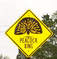
Frances Langford publicly photo.Standing before a giant photo of Frances Langford at Florida Oceanographic’s event 2013. (Photo Ed Lippisch)The former Langford Estate, cleared for development of Langford’s Landing, 2015. (Photo Jacqui Thurlow-Lippisch and Ed Lippisch)Local celebrity, Frances Langford, in her later years stands next to a pen containing peacocks on her property in Rio. The peacocks roamed freely on her land while she was alive. (Public photo)Sign in Rio.
As we all know, movie star and local philanthropists, Frances Langford, was and is very loved in Martin County. Nonetheless, recently her 53 acre river estate, in Rio, was mowed down for development to create ironically “Langford’s Landing.” Yes, it was legal, but what a shame. What a crime of local history. Part of that history included Frances’ flock of peacocks.
Invasive or not, Frances brought the exotic birds to her property in the 1940s and they had been happily living here ever since. They became part of the cultural landscape of the Rio area. Over the years the county even erected signs warning drivers about the birds.
After Frances’ death in 2005 there were tougher times for the peacocks, peahens, and peachicks but they managed to survive. They had become “wild” living off the land although some residents would joyfully feed them. Kind of like cardinals…. 🙂
Sometimes stopping traffic as they lollygagg across State Road 707, the birds cause smiles and sometimes cursing and horn blowing from drivers. Inconvenient? Maybe— but so cool! So local! So “Frances”…..a reminder of her philanthropic spirit and love for our area with every sighting!
Of course since the 53 acres has been clear-cut and scraped the peacocks have lost their home base habitat. Did anyone even think about this? I mentioned it at a county commission meeting years ago. Perhaps the county thought no one would notice when the birds fell on hard times or were possibly eradicated?
This was not the case. Not along the Indian River Lagoon…not in the land of River Warriors.
Yesterday there was a great win for the spirit of Frances Langford and the peacocks when resident Toni Rummo used social media to inform the public that a bank and real estate agency had “ordered the trapping of the peacocks at 1547 SW Sottlong Avenue.”
The house is in foreclosure and the cleaning people were apparently put off by all the birds. This led to the trapping or quote for such. According to Rummo some birds were trapped but after the outcry the others were left alone. Even the media, Sheriff’s department, and Martin County Commission got involved. It was crazy!
Than you to Toni Rummo and the others! Just to follow up, I spoke to Bill Dean head of Century 21 on Hutchinson Island whose company was incorrectly linked with the sale and he said it was a day like no other. The phone rang off the hook!
At the end of the conversation I said: “But isn’t it great? The love of Frances Langford and the people standing up for her spirit?”
We laughed. I recommended having a gin and tonic in her honor.
Thank you Toni for the peacock win! It was a win for the people of Rio. A win for the spirit of Frances Langford, and a win for the spirit of St Lucie River/ Indian River Lagoon!
One of Frances Langford’s peacocks in a royal poinciana tree on her estate.Rainbow over Langford Estate 2014. (Photo JTL)
Map showing Big Cypress Swamp next to the Everglades. Also note Lake Okeechobee.
The maps and information in today’s blog is taken from an article entitled “Big Cypress Swamp,” by Benjamin F. McPherson, that is included in the 1974, “Environments of South Florida Past and Present,” complied by Patrick J. Gleason. As I have mentioned previously this week, this text was lent to my by Dr Gary Goforth who gives insight into understanding our St Lucie River/Indian River Lagoon system and our Lake Okeechobee and canal issues.
….cover….The Everglades and Big Cypress Swamp.
This above map gives one an idea of how far east the Everglades used to go and how much development has crept in (see below)….how come agriculture and development didn’t totally take over Big Cypress? Well, perhaps they could not stop the water….
West of the red lines shows the edge of what was once the Everglades in South Florida. Development has crept and continues to creep over this edge. (Photo/map courtesy of Chappy Young,/GCY Surveyors, 2014.)
Big Cypress Swamp…we may not think of it too much over here on the east coast but we should study it as well. It is sister to the Everglades and people fought to save parts of it and were successful. It became one of our nation’s first national preserves in the same year Patrick Gleason’s text was published, 1974. I was ten years old and my family had just moved to a very undeveloped Sewall’s Point.
Today I will transcribe from the parts of the summary from McPherson’s work. I like reading the old texts. Sometimes they seem more clear and easier to understand. It helps us understand how things have changed looking an old book like we grew up with instead of today’s electronic media.
Excerpts from “Big Cypress Swamp,” by Benjamin F. McPherson
“The Big Cypress Swamp differs form the adjacent Everglades in topography, soil, water quality, and vegetation. Because the swamp has relatively more high land, inundation soil deposit are less extensive in the swamp than the Everglades. Soil in the swamp is usually a thin layer of marl sand or mixture of the two or is absent where limestone crops out where as soil in the Everglades is usually deeper organic peat. Vegetation in the swamp is closely associated with typography, water inundation, and soils, and is more diverse and forested than in the Everglades…
Big Cypress Swamp is a flat, swamp area of about 3120 square kilometers in SW Florida. It is seasonally inundated over as much as 90 % its surface area. Water moves slowly to the south by overland flow toward the estuaries. Fifty -six percent of the surface water that flows into Everglades National Park comes from the Big Cypress. A substantial amount of water also enters Conservation Area 3 from the Swamp. The western part of the Swamp is drained by canals and no longer floods extensively…
The quality of water in the big Cypress, particularly in the untrained parts is in generally of better quality that the water in the Everglades. Some contamination by metals pesticides and other potentially toxic chemicals does occur however….
Up close map 2 drainage of Big CypressFull summary from article
This week we will take a look back at Lake Okeechobee, a lake that since 1923–via the C-44 canal, has been connected to the St Lucie River/Indian River Lagoon.
Information for these posts is made possible through a book entitled “Environments of South Florida–Past and Present,” by Patrick J. Gleason. This text was lent to me by Dr Gary Goforth. I will transcribe portions of this rare and amazing text in order for us to contemplate the changes that have occurred and how those who first documented this once remote area experienced our region.
It continues to amaze me—the ability of the early map makers and surveyors who functioned without today’s technology.
For me it is noteworthy to notice how the original map of the lake “veers off to the south-east.” Looking below one can see that today this area is today’s Bell Glade and South Bay. These lands are the richest in “black gold” as they have the accumulation of thousands of years of muck. Now we can see why. Tremendous amounts of sugar and vegetable products are produced in this area. Also, I believe these lands are most valuable because they are less likely to freeze due to their proximity to the lake.
As we can see, although we must take the Captain’s map with a grain of salt–interestingly enough—this area was once the lake…
Today’s Google map, 2016.
Here are the words of Captain Backus for us to ponder as I transcribe:
In 1838 map produced by Captain E. Backus had produced a map of Lake Okeechobee, which for a long time remained buried in the national archives records of the Seminole War. It reveals the knowledge of the lake that time, and his version of the lower Kissimmee River shows graphically how that crooked meandering stream flowed thirty-five miles from Fort Basinger to reach the lake only eighteen miles away– as the crow flies… In a brief statement in the lower left portion of the map, Captain Backus writes: “Many small streams flow into the Okee-cho–bee on the North-East and West side and also on the South- East side, but it is not known that it has any outlet, and probably has none, except at the high water when Grassy Lake (The Everglades) and Okee-cho-bee are united, and probably empties thought some streams into the Atlantic. This is corroborated by the statements of different indians and negroes who profess to have crossed from one side to the other in a canoe at high-water, and to have carried and dragged a canoe many miles over the portage at low tide.”
I wonder how we would have seen the lake had we been there? Would you have crossed it in a canoe? What would you have dreamt it to become?
….The handwritten text….Book information and inside cover.
A fun thing about working on blog posts with my brother, Todd, is that I learn new words like “Bathymetry. ” It is the study of under water depths. Kind of like topography but underwater. Maybe you already knew the word; I did not! He got on this while we were studying the intense clearning of Frances Langford’s property….
Viewing this short video that compares a historic 1883 map with a 2015 Google map, one clearly sees the differences in the depths of the St Lucie River. It appears that in many areas along and just northwest of the peninsula of Sewall’s Point, where Frances Langford’s historic property is located, the river was as deep as 10 to 12 feet. Today depths are closer 7 or 8 feet or shallower. Mostly a build up of muck from 100 years of releases from Lake Okeechobee I would think….
As far as topography, heights on land, “Mount Pisgah” still stands like a sentinel as the highest point as 57 feet. There is where I always picture Black Beard standing when I drive of the bridge….
What an interesting video, for me, it is amazing to think of the surveyors in the 1800s who calculated such with none of today’s technology! Their maps are quite beautiful. I wonder what surveyor will use in the future?
There are only a handful of people who are qualified to help us navigate the turbulent and murky waters of Lake Okeechobee and its effects on our beloved St Lucie River/Indian River Lagoon….
One of these rare individuals is Dr Gary Goforth. “Gary” has more than 30 years of experience in water resources engineering, encompassing strategic planning, design, permitting, construction, operation and program management.
For the last 25 years, his focus has been on large-scale environmental restoration programs in the Kissimmee-Okeechobee-Everglades ecosystem. He was the Chief Consulting Engineer during the design, construction and operation of the $700 million Everglades Construction Project, containing over 41,000 acres of constructed wetlands.
With all this experience Gary spends a tremendous amount of time at River Coalition and SFWMD meetings, and with every day people, advocating to local, state, and national officials telling the story in a manner that the average person can understand but with the power and expertise of a scientist.
Dr Goforth teaches us that we CAN HOLD THE ACOE, AND ESPECIALLY THE SOUTH FLORIDA WATER MANAGEMENT DISTRICT ACCOUNTABLE.
We can ask such questions as “are you sending the maximum practicable amount of water south?” “Is it 28% more than in 1994 as required by the Everglades Forever Act?” ” Is an average per year of 250,000 acre feet going south from the lake to the Everglades as required by the Everglades Forever Act?” “Are the Storm Water Treatment Areas being used to full capacity?” “Is the truth of the destruction of the estuaries being reported?” “Should 2008 LORS, Lake Okeechobee Regulation Schedule, been revised?” “Should the Everglades Settlement’s Q-Bell (limit of Phosphorus) be reviewed-is it realistic?” “Is a large reservoir being created in the Everglades Agricultural Area as is called for in the Central Everglades Restoration Plan?” “Who are the Lake and the STAs really serving?”
In order to hold the agencies accountable we must be educated! We must ask questions. We must look at the figures for water flowing south of the lake every year and compare.
Dr Goforth provides regular public updates on these issues, directly and indirectly holding the fire to the agencies. Today I am publishing in full his DRAFT–WET SEASON 2015 LAKE DISCHARGE report.
Please read it, study it, familiarize yourself with it. Dr Goforth has a website if you have any questions. Thank you Dr Goforth for the gift of shared knowledge. It is the greatest gift of all.
Draft – Wet Season 2015 Lake Discharges by Dr Gary Goforth:
Goforth – December 18, 2015
Flows into and out of Lake Okeechobee were examined for the period May 1, 2015 – October 31, 2015, corresponding to the first half of the annual water year (May 2015 to April 2016), and roughly corresponding to the south Florida wet season. The flows and associated Lake water levels were compared to same period from last year. In light of the influence of the current strong El Nino, Lake water levels were compared to the levels that occurred during May- November 1997 which preceded over 1 million acre feet (347 billion gallons) of destructive Lake releases to the St. Lucie Estuary between December 1997 and May 1998.
Flows into Lake Okeechobee – excluding rainfall. For the period May 1 to October 31, 2015, surface inflows to Lake Okeechobee amounted to 1.43 million acre feet (466 billion gallons) (Table 1). This is 20 percent less than for the same period in 2014 (Table 2 and Figure 1).
Flows out of Lake Okeechobee – excluding evapotranspiration. For the period May 1 to October 31, 2015, surface outflows from Lake Okeechobee amounted to 780,000 acre feet (254 billion gallons) (Table 3). This is 37 percent more than for the same period in 2014 (Table 4 and Figure 2). Approximately 30 percent more Lake water was sent to the EAA and L-8 Canals during 2015 than 2014, likely in response to higher water supply demands (due to lower rainfall than in 2014).
Lake Okeechobee water levels. The level of Lake Okeechobee varied from 13.81 ft on May 1 to 14.55 ft on October 31, 2015, reaching a low level of 11.96 ft on July 16 (Figure 3). For 2014, the level of Lake Okeechobee varied from 13.07 ft on May 1 to 15.85 ft on October 31, reaching a low level of 12.32 ft on June 11. Lake water levels rose only 0.74 feet during the 2015 wet season compared with a rise of 2.78 ft during the same period in 2014. The Lake level on October 31, 2015 was approximately 1.3 ft lower than it was a year earlier, and approximately 0.5 ft lower than October 31, 1997 (Figure 4). In addition, the Lake level on November 30, 2015 was approximately 1 ft lower than it was on November 30, 1997, which preceded over 1 million acre feet (347 billion gallons) of destructive Lake releases to the St. Lucie Estuary between December 1997 and May 1998. Two important differences between 1997 and today that could influence Lake discharges to the estuary include rainfall over the Lake Okeechobee watershed and the regulation schedules governing Lake operations. According to the South Florida Water Management District (District), November 2015 was the wettest November since 1998, indicating inflows to the Lake over the next month may be substantially larger than average. Additionally, the Lake is currently operated under the LORS2008 schedule which was anticipated to result in increased frequency and magnitude of Lake releases to the estuaries compared to the regulation schedule in place during 1997-1998.
Lake flows to the STAs. Beginning in August 2015, the District began operating the EAA A-1 Flow Equalization Basin (FEB), which is approximately 15,000 acres in size and can store water up to 4 feet deep. The FEB can receive Lake releases and EAA runoff, and distribute flows either to STA-2, STA-3/4 or to the EAA for irrigation. At this time incomplete flow records are available to the public through the District’s DBHYDRO database to fully account for the various flow paths, and until additional data are available, the estimates of Lake releases and runoff to STA-2 and STA-3/4 will be subject to revision. Using these preliminary estimates, approximately 13 percent less Lake water has been sent to the STAs in 2015 compared with 2014 (Figures 5 and 6 and Table 5). During the same period, approximately 32 percent less basin runoff was sent to the STAs, reflecting less wet season rainfall in 2015.
Flows to the estuaries. Lower rainfall in 2015 resulted in less basin runoff to the estuaries for the period May to October than occurred in 2014 (Table 6). However, due to the Lake releases that occurred during January through May 2015, Lake discharges to the estuaries in 2015 far exceeded Lake releases during 2014.
SUMMARY. Lower rainfall during the May to October 2015 period resulted in about 20 percent less inflows to Lake Okeechobee than in 2014. However, outflows from the Lake increased compared to 2014, likely in response to higher water supply demands (due to lower rainfall than in 2014). Lake water levels rose only 0.74 feet during the 2015 wet season compared with a rise of 2.78 ft during the same period in 2014. The Lake level at the end of October 2015 was about 1.3 ft lower than in 2014. In addition, the Lake level on November 30, 2015 was approximately 1 ft lower than it was on the same date on November 30, 1997, which preceded over 1 million acre feet (347 billion gallons) of destructive Lake releases to the St. Lucie Estuary between December 1997 and May 1998. However, differences in rainfall and Lake regulation schedules prevent a forecast of potential 2016 Lake discharges compared to the 1997-1998 discharges to the estuaries based on Lake levels at the end of November.
May 1925 aerial for the Sailfish Club by Bob Higgins shared by historian Sandra Henderson Thurlow.
This amazing 1925 aerial photograph of the confluence of the St Lucie River and Indian River Lagoon tells a story….I found this photo looking back through some old emails between me, my mother, and my brother dated 2010. At the time, I did not catch all of the nuances in the photograph….
For instance, look at the beautiful, healthy seagrasses hugging the elbow of the shoreline of Hutchinson Island; what about the dock in the midst of the seagrasses that is no longer there; the gentle, crashing waves over a thriving reef at “Bathtub Beach;” the entire area so pristine with extensive natural vegetation. Look at the wispy sandbars forming in the river… Nearby the St Lucie Inlet had been permanently opened, (1892), but also much “improved,” as 1925 was just before the real estate crash, great depression, and two hurricanes that altered Florida’s history forever.
In 1925, community leaders were actually planning a port, Port Sewall, one to complete with Miami and Jacksonville right in this area! In fact they dug a turning basin for ships just off the southern tip of Sewall’s Point and created Sandsprit Park with the fill. Can you imagine?
Back to the photo…
Notice there were no spoil islands off of Sewall’s Point–no Archipelago or Island Addition…Notice the sparse development of Stuart and the lack of an airport. Notice the basically undeveloped peninsula of Sewall’s Point, Rocky Point, and the even less developed— later named— “Sailfish Point.”….The Manatee Pocket just east of and beyond Sewall’s Point shows some signs of the coming future but not many….Do you see anything else?
For me the most interesting thing of all was caught by my brother Todd’s keen eye.
“What is that huge white stripe on the horizon??” He said. “It’s looks like a giant 20-mile-long spaceship runway. Well, it’s the spoil from the freshly-dug Okeechobee waterway. See it in the attached comparison from Google Earth.”
Looking upward and beyond in the 1925 photograph to the right of the clouds, Todd noticed the piled up sands of the C-44 canal—a long curving snake connecting Lake Okeechobee to the South Fork of the St Lucie River. Can you see them?
Of course we all know that this canal along with others and extensive development, over time, destroyed the healthy seagrasses, great fishing, negatively altering the beautiful paradise of the St Lucie River/Indian River Lagoon..
It’s fun to look back, but its even more fun to think about how we have the ability to improve things in the future.
….Google image 2010 showing C-44 canal to compare to 1925 aerial. (Todd Thurlow)
Sewall’s Point Post Office ca. 1890s. Photo courtesy of Historic Society of Martin County and Sandra Henderson Thurlow.
Certain photographs become imprinted in our minds, affecting us on an emotional level–conjuring up images and memories again and again….
One such photo for me is this late 1800s image of Captain Henry Sewall’s Post Office and home. The picture graces the cover of my mother’s book “Sewall’s Point, A History of a Peninsular Community on Florida’s Treasure Coast.” This photograph was often laid out on our family dining room table and we kids listened to mom tell stories of the house and the people from that era of history.
The first time I ever saw the photo it was like I was walking along the long, crooked dock myself to say “hello” or go pick up the mail. I could imagine a gentle breeze blowing, the sun shining, the birds flying over, the fish jumping, and yes, maybe a mosquito or two….
In my imagination, I also thought about how happy I would be to say “hi” to the Sewalls and to maybe get some mail…My mother in her years of writing the books repeatedly pointed out how “lonely” it was for the pioneers, and that the post office played a social role in the community as well as one of function.
With no roads, the St Lucie River/Indian River Lagoon—were the roads—the only means of transportation to greet a neighbor, get supplies, or pick up the mail. The river brought people tougher, just like it does today.
Yesterday, when I drove to today’s Stuart Post Office from Sewall’s Point to drop off Ed and my Christmas cards, I thought about how much things have changed.
But I have to say, that even though I did not recognize anyone at the post office, the holiday mood and bustle of mail led to many smiles just as it must have in the days of Captain Henry Sewall. The post office, even with all of the world’s changes, still holds the heart of “greetings and hellos,” especially during the holidays.
SEWALL POST OFFICE/HOUSE TIMELINE
1889: Capt. Henry Sewall builds a house on Sewall’s Point
1891: Sewall’s Point post office established in the house
1913: The house is moved by barge to Port Sewall
2006: The house is moved by barge to Indian RiverSide Park with unanimous support from the Martin County Commission and advocacy of historian Sandra Thurlow, Stuart Heritage, the Historical Society of Martin County and others. A large donation is made to support the move by Mr. Fred Ayers.
2012: Restoration of the house is completed/the house is listed as one of 11 properties on the Martin County Local Historic Register of Historic Places.
Merry Christmas and Happy Holidays!
Jacqui
Jacqui Thurlow-Lippisch
Sewall House and Post Office tip of South Sewall’s Point, ca 1890s. HSMC
All of Sandra Thurlow’s books can be purchased at the Stuart Heritage Museum (http://www.stuartheritagemuseum.com) on Flagler Avenue, the Elliott Museum, or ordered on Amazon.
Sofia slide on fish lesions in SLR 1999.Slide from Dr Gary Goforth’s December 2015 update on SLR/IRL Lake Okeechobee.
Today I would like to briefly remember 1997 and 1998 and recall why this year is so important to our St Lucie River/Indian River Lagoon history. I would also like to note for some who may not know why these years are being brought back into the ACOE/SFWMD discussion this year.
Today’s slide is complements of a recent document shared by our friend, Dr Gary Goforth. (http://garygoforth.net) “Draft – Wet Season 2015 Lake Discharges – December 9, 2015.” This slide shows that Lake Okeechobee today is lower than it was in 1997.
Why is Dr Goforth comparing 1997? He is comparing 1997 because in 1997-98 there was a strong El Nino (rainy winter), just as we are experiencing right now in 2015/2016.
Certainly we have all noticed how much it is raining this winter so far!
The difference as far a Lake O management in 1997-98 was that there was no”LORS” schedule then….The 2008 LORS or “Lake Okeechobee Release Schedule” did not go into place until 2008 so prior to that year the lake was allowed to be over a foot higher. Since 2008, the lake is required to be lower because of work and safety issues on the Herbert Hoover Dike.
It is important that as we move forward to also look back. We must remember what happened in 1997-98, a similar El Nino to what is happening right now…. 1997-98 were not good years for the river…So much water was released into the St Lucie River/Indian River Lagoon in 1997-1998 that there were more reported fish lessons than ever before– due to too much and too long of exposure to fresh water. This is also why, in 1998,the Rivers Coalition was born. (http://riverscoalition.org)
Section of Dr Goforth’s report on Lake O levels December 9, 2015.
El Nino means possible heavy rains for our SLR/IRL region during the coming winter.
I woke up this morning to the percussion of hard, fast rains hitting our tin roof… In my foggy state of slumber, I bumped Ed’s shoulder, “How are you going to take out the dogs?”
Rolling over, I started thinking about what I’d heard on Tuesday’s Army Corp of Engineer Periodic Scientist Call: “…How are we going to prepare if NOAA’s El Nino rain predictions are right? What if there is up to seven feet of water that fills the lake?….”
Seven feet? That would mean releases from Lake Okeechobee this Florida winter.
Remember 2008 and Tropical Storm Fay? For reference, that storm raised Lake Okeechobee by more than three feet in no more than few weeks. The lake fills up six times faster than it can be “drained”….and as we all know, we are the drainage pipe.
It’s an odd thing how the flow of water going south to the Everglades is blocked by the EAA (Everglades Agricultural Area) so now the over-flow is directed to the St Lucie River and Caloosahatchee. But it’s a reality. A reality that one day must be changed.
We must restore the flow of water to the Everglades and halt releases to the SLR/IRL. This requires land purchases and reservoirs.
Remember–too much fresh water, as during releases from Lake Okeechobee, is a pollutant to our St Lucie River/Indian River Lagoon— altering salinity, destroying spawning/fisheries, wiping out seagrasses and food throughout the food chain, lowering property values and the right of residents and their children to have “peaceful enjoyment” of their property…Yes, I can clearly state that toxic algae blooms and fish lesions do not precipitate peace for the Town of Sewall’s Point, nor for Martin and St Lucie Counties.
So how do we prepare? We must educate ourselves ahead of time; we shouldn’t over fertilize; we should get our septic tanks checked; and we should contact our legislators now saying we want to see a plan. We want to know ahead of time what may happen if indeed seven feet of water fills the lake between December and this coming May. How will we adapt to knowns and unknowns? We can’t just wait. Not when it’s this clear…we must be proactive on every level.
Legislative delegation Senate President Negron, Representative Harrell and Magar, what are we doing now to deal with all this water and what are we going to do in the future? The C-44 Reservoir/STA is great but it does not address Lake Okeechobee…. Why are we wasting the valuable water? What about Amendment 1 and the purchase of lands?
The barrier island of Hutchinson Island, 1957. Atlantic Ocean on left. Indian River Lagoon on right. Photo courtesy of Thurlow Archives.
The sands of time….shifting, reforming, just like my childhood memories. 1977–Seventh grade—I remember riding my bike with my best friend, Vicki, out to Hutchinson Island. No traffic. Along the way we would take our hands off the handle bars holding them over our heads, laughing and shouting “look mom!”
A veritable paradise and giant playground we left our bikes at Stuart Beach not locking them and jumped into the ocean.
This photo was taken in 1957, twenty years before Vicki and my bike ride, but it was still relatively undeveloped at that time. If my memory serves me correctly Indian River Plantation’s first condo, The Pelican, went up in 1976 and later in the 1980s the establishment filled out to its final glory. Later sold to the Marriott these lands, though altered, remain a beautiful part of Martin County with public beaches for all to enjoy.
I got ahold of this photo from my mother asking her what kind of vegetation pre-development was on the island. This was her reply:
“This aerial was taken on October 16, 1957. The causeway was under construction as were improvements to Stuart Beach. It is hard to tell what kind of trees are there. They were probably a variety of things, oak, salt bush, cabbage palms, palmetto and Australian pine. The later were growing at the House of Refuge at this time so they were no doubt popping up everywhere. It was “disturbed land” since patches of it had been cleared for farming. Mangrove would be growing along the water but I doubt they had reached inland yet. You can see the new piles of sand indicating mosquito ditches had recently been dug. Notice the little Beach Road.” Historian, Sandra Henderson Thurlow
Thinking a bit more about this area I asked my brother, Todd Thurlow, if this area formed “the fan” because it was once an inlet, such as the Gap, he talks about so much. He sent me this:
“The steady forces of long shore drift have operated over the eons to produce not just the current BI and previous BIs such as the ACR on the mainland, but even the peninsula of Florida itself (Schmidt 1997). The strong linearity of the east central and southeast Florida coastline, its low fractal dimensionality (Rial n.d.), indicates the steadiness and consistent directionality of these forces. Chaotic events like storms, on the other hand, produce drastic BI and lagoonal modifications via overwash and tidal inlet cuts, and leave chaotic, or irregular (“squiggly”) backbarrier shorelines, the former producing overwash fans, and the latter producing flood tidal deltas (Figure 3-6).
Figure 4-19. Cartographic signatures of geomorphic stability and instability. Map to left is most north, right map is most south”
Alan Brech, NEITHER OCEAN NOR CONTINENT: CORRELATING THE ARCHAEOLOGY AND GEOMORPHOLOGY OF THE BARRIER ISLANDS OF EAST CENTRAL FLORIDA, 2004.
——————————
Translation: Breaks occurring during storms create overwash fans. (e.g. IRP and Sailfish Point). Tidal inlets produce flood tidal deltas, somewhat like the old Gilberts Bar. BI = Barrier Island; ACR = Atlantic Coastal Ridge. —-Todd Thurlow, “Time Capsule Flights:”(https://www.youtube.com/playlist?list=PLDaNwdmfhj15bmGNQaGhog9QpkQPAXl06)
The shifting sands of time… So many wonderful memories, and so many more to make as times and sands continue to change.
IRP Marriott today, Google Maps 2015.Wide view, red dot is IRP Marriott 2015. Sewall’s Point east.
Learning how to make cheese at Ground Floor Farm in Downtown Stuart with hostess Lindsey Donigan, guests, and owner Jackie Vitale.Located at 100 SE MLK Blvd. Stuart, FL 34994.Owners of Ground Floor Farm: Jackie Vitale, Micah Hartman, Mike Meier.The entrance to “the farm….”Inside, my husband ,Ed, learning about growing greens with minimal and non-synthetic fertilizers.Hydroponics teaches recycling and re-use of water and how to avoid use of pesticides.Busy Bees!
Over the past year, I have watched this new City of Stuart icon grow from the ground up, but not until yesterday did I enter. It is located right across the street from my father and brother’s law offices, Thurlow and Thurlow, so I have seen it many times. A large parcel that was formerly the Salvation Army is now painted green, fenced, and having a rebirth as the new urban chic “Ground Floor Farm.”
Yes, urban agriculture is hip and bringing a healthy, and community business minded spirit to the St Lucie/Indian River Lagoon Region. Words like homesteading, self-reliance, chickens, and interdependence ring with new meaning and inspiration. Making and growing your own food is cool. Hydroponics teaches about water quality, conservation, and re-use and no pesticides.
Learning how easy it is to make cheese from owner Jackie Vitale —the process of “curds and whey,” was the beginning of real understanding for me!
The event was hosted by Sewall’s Point residents Dean MacMillian and Lindsey Donigan. They invited about sixty of their closest friends to “Come Down on the Farm,” to showcase and help people learn about Ground Floor Farm. Owners Jackie Vitale, Micah Hartman, and Mike Meier shared their story of Ground Floor Farm and their vision for a hip and sustainable future for the City of Stuart, and for Martin County.
It was an amazing evening seeing the younger generation teach and inspire the older generation. As population continues to grow, and resources become more precious, a sustainable path to the future is finding its place. Such a path will continue to revitalize the City of Stuart, bring us all closer to home, and to each other. Kudos Jackie, Micah, and Mike for your creative business model and for your leadership!
To learn more about Ground Floor Farms if you have not visited stop by Wednesdays 3-7pm, October-May, and visit their farmstand. Their address is 100 SE MLK Blvd. in Downtown Stuart. To learn how to visit or become part: (http://www.groundfloorfarm.com)
Like them on Facebook: (https://www.facebook.com/groundfloorfarm/?fref=ts)
________________________ THEIR VISION:“We want Ground Floor Farm to be a part of a hometown renaissance, in which individuals focus their energy and creativity on the places they come from and through which the importance of a vibrant community center is reclaimed and revitalized. THEIR MISSION “Grow and produce delicious food and give others the tools and resources to do so themselves. Show that productive agriculture can take place in small spaces in urban centers and that it can be economically sustainable. Provide the space and resources for others to use their talents, skills, and interests to engage their community.Curate an exciting and diverse program of cultural and social events that engage the hearts and minds of our community.” GFF
Touring the farm.Ricotta cheese the group made all by itself was eaten along with other fresh foods for dinner.Deane MacMillan with Mark and Nancy Perry. Deane served as the chair of Florida Oceanographic.Jackie Vitale, Micha Hartman, JTL, Mike Meier.Interested? Attend the Make. Share. Do. Summit:(http://www.groundfloorfarm.com/makesharedotickets/)
C-44 canal with Coca Cola’s Minute Maid Orange Groves, 1964. Photo Arthur Ruhnke courtesy of historian Sandra Henderson Thurlow.SFWMD including C-44 R/STA in blue, 2014. This area was once Minute Maid’s orange groves.
The C-44 Reservoir and Storm Water Treatment Area has been in the news over the past few years. Once completed by the SFWMD and ACOE with help funds raised locally, it will clean water from the tremendous and polluting C-44 basin. It is one component of the Indian River Lagoon South Project that is part of the Central Everglades Restoration Plan. But what was all that land used for in the past? That land was orange groves. Thousands and thousands of acres of orange groves! As far as the eye could see….
Today even with the area’s transformation to STA/Reservoir, “Coca Cola” and “Minute Maid” roads remain as reminders of an all too distant past…when oranges were healthy and the St Lucie River/Indian River Lagoon was not impaired.
Today I will share eleven incredible 1964 aerial Ruhnke aerials my mother stumbled upon while creating a presentation for the Martin County Property Appraiser’s office. Arthur Ruhnke photographs are so important to our understanding of our history and I thank my mother for sharing these treasures. Art was a well-known photographer in his day and my parents acquired many of his photos.
The following is an exchange with my mother, Sandy, and long time family friend Jack Norris, who was an executive for Minute Maid. In the exchange, they “talk”about these photographs. Their interplay tells the story best, so I have gotten permission to share.
—-Jack, Tonight Fred asked me if I had any images to illustrate the his Citrus Program. These are from a packet of 10 Ruhnke negatives marked Minute Maid Groves, Indiantown, 1964. Surely the canal shown isn’t C-44? Are those workers’ houses? Sandy
—- Sandy”Hi Sandy – The barn, equipment storage & office are located in the NW corner of the intersection, the buildings in the SW and NE are workers houses, and the buildings in the SE corner are supervisors houses. The canal running N&S was the main source of irrigation, originating at the St. Lucie at the site of the rodeo bowl. It is now substantially enlarged by the SFWMD to carry water to the new reservoir. The NS canal and l the main drainage canal was owned and operated by the Troup – Indiantown Drainage District.” Jack
So then my mother sends this email to me:
—-Jacqui, I am working on my program for the Property Appraisers and thought I needed to say something about western Martin County. I thought I might show the old Minute Maid Grove and say it is now a reservoir. I couldn’t find my aerials. I have finally found them and thought I would share them with you. Understanding them would be an education. Jack Norris was in charge of planting all of those millions of citrus trees.
So I today I am sharing the photos and started researching Minute Maid and the land purchase for the C-44 STA/R; this is what I found: According to a 2011 Stuart News article bout C-44 R/STA by Jim Mayfield:
“The project site, 12,000 acres of former citrus land, was purchased in 2007 for $168 million, $27 million of which came from Martin County taxpayers through the one-cent sales tax for conservation lands, South Florida Water Management officials said. The property is south of the Allapattah Flats Wildlife Management Area near Indiantown. Over the last year, the water management district has spent roughly $5 million to remove trees and rid the topsoil of copper deposits, officials said.” Jim Mayfield
I hope you enjoy these historic photos today. I find these aerials amazing! It is my hope that one day even more of this agricultural land will be converted to hold water as Nature intended. The C-44 STA/Reservoir is a great start.
Orange Groves and C-44 canal. All photographs below taken in 1964 by Arthur Ruhnke and shared by historian Sandra Henderson Thurlow.…..….…….….….………
“Here is one of your pictures – here and now”
(Cool video with historic maps and Google Earth fly over by my brother Todd Thurlow: (https://youtu.be/i9h1d1pzfww)
___________________________________________________
This ACOE sponsored video gives an artists rendition of what the C-44 R/STA will achieve for water polluted by agricultural runoff once complete:video: (https://www.youtube.com/watch?v=4BsC0BoIPJ4)
Stuart’s City Seal The original seal of Stuart was designed by a committee of three, A. T. Hogarth, J. A. Hancock and Curt Schroeder. It showed the confluence of the north and south forks of the St. Lucie River and the Florida East Coast railroad bridge. The original seal, adopted when Stuart was incorporated on May 7, 1914, served through the 1970s. (Sandra Henderson Thurlow, Stuart on the St Lucie)
The ironies of life in Stuart and Martin County are grand.
Here are a few:
Business tycoon, Henry Flagler, is said to have first planned to run his railway through and develop Sewall’s Point and then across the St Lucie River to Rocky Point rather than developing Palm Beach. Title problems with the Hanson Grant, of which Sewall’s Point encompassed, led Henry to change the path of his railroad, instead taking it through Potsdam, later named Stuart.
Stuart’s orignal seal, adopted in 1914, shows only the railroad going through Stuart as there was no “auto bridge” at that time. The docks sticking out into the St Lucie River can be seen on the seal due to their importance to property and commerce at that time in history. —The St Lucie River was important to “commerce” like the train at that time.
Stuart was first on the north side of the railroad over the St Lucie River. When leaders wanted to change the name to “Port St Lucie” the railroad company “denied” this as there was already a town by the same name north. So the clever leaders of the town just moved the train station over the river to Potsdam and changed the name to Stuart. When things don’t work, smart business men take another path…
All Aboard Florida and East Coast Railroad, Henry Flagler’s company, is now owned by Fortress; their plan to expand Mr Flagler’s business is likely to fail.
City of Stuart seal showed the railroad and an auto bridge in 1978. Seal taken from city stationary. Courtesy of Sandra Henderson Thurlow.
Today proposed All Aboard Florida is not following Henry Flagler’s one famous quote: “To help others is to help yourself,” in the age of paternalism such was the justification of the railroad….not today… Fortress Corporation is doing nothing to help others, like putting a stop at every pineapple plantation, but rather figuring how much money they can make for themselves barreling right through and then failing for bigger and better things…like Panama Canal freight. Luckily their plan is falling apart.
The following information was simplified and explained by Mr Len Sucsy, of CARE, Citizens Against Railroad Expansion. He is a business expert. He gives us the inside scoop in layman terms we can understand.
You probably know about the Martin County and Indian River County lawsuits that are pending, but the specifics of All Aboard Florida’s failing business deal makes its vulnerability easier to understand:
“All Aboard Florida is having difficulty selling their $1.7 billion tax exempt, junk bond issue. Municipal bond investors are being quoted in Bloomberg, the Chicago Tribune, and other media sources as being “uncomfortable” with the business model not only because no passenger train in the history of the country has been profitable but also the real estate above and around some train stations is speculative and yet to be built. Other freight rail cash-flowing services are also future events and speculative. The high leverage of the deal is also been noted…. a problem. A well known muni manger of a $36 billion fund passed on the deal for “credit risk” reasons.
Fortress, Inc., parent company of All Aboard Florida and Florida East Coast Railway, is closing its flagship macro hedge fund. At its peak, it managed $1.6 billion which now stands at $400 million due to investor flight. Last year the fund lost .6% and this year is down 17.5%. Managing partner and billionaire co-founder of Fortress, Michael Novogratz will leave the firm. The company share price (FIG, NASDQ) has dropped 32% this year…”
AAF CAN’T SELL ITS BONDS. THEY ARE A BAD DEAL. SPREAD THE WORD. WRITE IT ON FACEBOOK. CALL YOUR FRIENDS UP NORTH. PUT UP A SIGN.
Maybe our sign should read: “HENRY FLAGLER WOULDN’T HAVE BOUGHT AAF BONDS.”
A train on the original wooden bridge that spanned the St Lucie River 1894. Historical Society of Martin County via Sandra H. Thurlow’s book St on the St Lucie.
“Isle Addition” far left. March 1966. Peninsula of Sewall’s Point with roads at High Point are also visible. Looking south at confluence of St Lucie River/Indian River Lagoon. (Photo Arthur Ruhnke via Sandra Henderson Thurlow’s book Sewall’s Point.)
Today I am going to share some aerial photographs that showcase development in Sewall’s Point during the 1960s, specifically, Isle Edition and Archipelago. To give reference, I was born in 1964. During this time and before, the bulkheading of spoil islands was fashionable. Due to environmental restrictions that were put into law in the 1970s, development on such a scale is no longer allowed.
Bulkheading is basically when one creates a seawall. In the case of a some of the islands off the Town of Sewall’s Point, they were cleared, bulkheaded, filled with sand, and then developed. In some instances the fill is high enough that these islands are not completely in same flood zones as surrounding areas.
According to my mother’s book, “Sewall’s Point, A History of a Peninsular Community on Florida’s Treasure Coast:”
“High Point’s “Isle Addition” was developed by Bessemer in 1966, during the same years Perry Boswell developed Archipelago. Both subdivisions are on bulkheaded islands that were augmented by dredge-and-fill operations. Since laws no longer allow this type of development, there will never be another one on Sewall’s Point.” -Sandra Henderson Thurlow
Looking north. This aerial photograph taken in 1960 shows the spoil islands which were to become Isle Addition and Archipelago. Archipelago is further north. (Dillion Reynolds Aerial Photography via Sandra Henderson Thurlow’s book Sewall’s Point.)
The islands I am referring to are spoil islands. They are not natural islands. These islands were created by the ACOE. The 156 mile long Indian River Lagoon has 137 spoil islands; they were formed from 1953 to 1961 when the U.S. Army Corps of Engineers dredged the Intracoastal Waterway — the main channel through the center of the lagoon. The Corps left behind heaps of sand on either side of the channel.
Archipelago first developed in 1964. Photo courtesy of Sandra Henderson Thurlow.
I am including this video my brother Todd created about the spoil islands from an earlier blog as it is most fascinating as is the coast history of our St Lucie River/Indian River Lagoon region. Enjoy!
Photo from “Flight to Everglades City,” (Photo Jenny Flaugh (2007)My niece Evie with her mom, my little sister, Jenny Flaugh. “Flight to Everglades” with my husband Ed, 2007)…..Robert Fennema’s presentation slide , GEER 2008 about water going south to the Everglades…SFWMD map showing STAs and WCAs. Storm Water Treatment Areas’s (STA) vegetation etc. clean the water of excess phosphorus and nitrogen coming from agriculture and development. Then the flows into the Water Conservation Areas (WCA)/Everglades hopefully meeting standards.……
GOAL: Sending water to the Everglades!
The South Florida Water Management District did a great job “sending water south,” from May-September last year, so how are they doing so far this year comparatively? Recently I asked Dr Gary Goforth (http://garygoforth.net) if I could share his calculations:
Jacqui, As you know, my mantra has been to send the Lake water south – slowly but steadily – throughout the year.
This was echoed by Robert Fennema describing historical flows from the Lake to the Everglades in the same 2008 Greater Everglades Ecosystem Restoration (GEER) workshop as the Chris McVoy piece you referenced recently: “Persistent outflow along the southern shore provided the head to maintain constant flow through the Everglades.”
All the best, Gary
Here are Dr Gary Goforth’s numbers:
2 years ago May-Sept: 32,032 acre feet to STAs Last year May-Sept: 187,125 acre feet to STAs This year May – Sept.: 95,600 acre feet to STA/FEB
He adds: “Jeff Kivett stated there was 60% probability of above average rainfall during the upcoming dry season and now is the time to keep the Lake low by sending it to the Everglades.”
Thank you Dr Goforth.
I have noticed, at recent meetings, speakers and scientists for the SFWMD note that rainfall and other issues have a lot to do with how much water they can send south. It would be wonderful if someone from the District could explain this in simple terms for the public and noting the goal for this year. Please feel free to participate in this blog.
As we all know, sending water south and working on more ways to achieve such is imperative for restoring the Everglades and for saving the St Lucie River Indian River Lagoon. This power point presentation by Robert Femema (http://conference.ifas.ufl.edu/geer2008/Presentation_PDFs/Wednesday/Royal%20Palm%20VI/1200%20R%20Fennema.pdf) was given in 2008 at the GEER conference and is another great resource for those of us learning as much as we can about creating a better water future for ourselves, our children, and grandchildren.
South Bay is approximately 5.8 miles from open water, it was once “in” water. Lake O has been drained and altered for agriculture over the past 100 years with most drainage occurring after the 1926 and 1928 hurricanes. (Slide from Todd Thurlow’s presentation)The red line shows where a former canal was located and filled in. The square is Section 2, Township 44, Row 36E, once custard apples and a “dead river” part of the lake, now sugar fileds. (Todd Thurlow.)
Published on Oct 16, 2015
This overlay flight shows the following maps:
– 1907 Official Map of the Everglades Patent 137 conveyed to Florida on January 2, 1905
– Map of the Everglades Patent 137 re-recorded in Plat Books of Broward County, originally recorded in Plat Book B, Page 131, Dade County Florida
– 1924-1925 USCGS Maps of the Airplane Survey of Lake Okeechobee
After taking a counterclockwise lap around the shoreline of Lake Okeechobee while viewing the 1925 surveys, we return to South Bay.
Section 2 of Township 44 South, Range 36 East, north of the town of South Bay, was originally under the waters of South Bay. On 12/31/1888 that section was conveyed by TIFF to the Pensacola and Atlantic Railroad Company. The area of the Lake is now sugarcane farms.
Lake Okeechobee used to be a much larger lake. It crested at about 21 feet to fall over an undefined edge of sawgrass and in some areas a pond apple forest.
Since the late 1800s the lake has slowly had its undefined edge pushed back and dammed. The lake perhaps holds about 30% less water than it originally could. Those overflow waters today are plumed to drain into the St Lucie River/Indian River Lagoon and the Caloosahatchee so that the Everglades Agricultural Area (EAA) can exist. Watch this amazing historic map/Google Earth video created by my brother Todd Thurlow and see for yourself!
South Bay, for instance…Todd explains: “You can see on Google Earth where the canals and levees follow the old shoreline of South Bay, now 5.8 miles from open water, but 2 miles from the rim canal. That Section 2, which was under the bay, was conveyed to the Pensacola and Atlantic Railroad Company by TIIF deed on 12/31/1888. It looks like there is a little town there called South Bay…”
A mullet jumps in the St Lucie River off North River Shores. (Photo Todd Thurlow, 10-10-15.)
Mullet are famous for being excellent jumpers. In fact, Florida Fish and Wildlife states “it’s often easy to identify their locations by simply watching for jumping fish.” Me? When I see a mullet jump, I have a tendency to personify thinking, “now there’s a happy fish!”
This beautiful jumping mullet-sunset photo was taken by my brother, Todd Thurlow, this past Saturday evening, October 10th, 2015 just off of North River Shores.
Former Stuart News editor and river advocate Ernest Lyons wrote about mullet jumping in his essay ” Never a River Like the St Lucie Back Then.”
There was never a river to compare to Florida’s St Lucie I when I was young….the river fed us. You could get all the big fat mullet you wanted with a castnet or a spear. If you were real lazy, you could leave a lantern burning in a tethered rowboat overnight and a half-dozen mullet would jump in, ready to be picked off the boat bottom next morning….at the headwaters of the south fork of the St Lucie….the waters were clear as crystal… (Ernest Lyons 1915-1990)
Today, the water of St Lucie River/Indian River Lagoon are anything but clear, but “hail to the mullet that are still jumping!”
Sunset over the St Lucie, Todd Thurlow, 10-10-15.……….
St Lucie Inlet, plume exiting SLR at Crossroads of SLR/IRL. 10-3-15. Photo Dr Scott Kuhns.
I am supposed to be on a blog break, but I did not want to miss the chance for Dr Scott Kuhns’ photos to be documented. Dr Kuhns has a much better camera than Ed or myself who use our iPhones. These photos were taken on Saturday, October 3, around 11:00am, 2015, with a Nikon D750.
So far this year, the St Lucie River/Indian River Lagoon has avoided the releases from Lake Okeechobee, and we were fortune that Hurricane Joaquin did not hit Florida which certainly would have filled up that lake. Nevertheless, we have been getting the discharges from regional canals C-23, C-24, C-44 and C-25 up in Ft Pierce.
While this fresh water is running off Martin, St Lucie, Okeechobee, and Indian River County, and being dumped to tide through our ailing rivers, Lake Okeechobee is filling up from the Kissimmee and other tributaries.
10-3-15 plume rounds Jupiter Island south of St Lucie Inlet, Hutchinson Island over near shore reefs. Sailfish Point on right. (Kuhns)10-3-15 —-(Kuhns)10-3-15 over Sailfish Point. (Kuhns)SFWMD discharge chart from ACOE Per. Scientist Call 10-29-15SFWMD basin/canal map, 10-29-15.SFWMD salinity chart SLR Roosevelt Bridge.10-29-15.Thie big picture… image courtesy of the EF.
Lake Okeechobee’s level today is at 14.77 NGVD. (http://w3.saj.usace.army.mil/h2o/currentLL.shtml) Hurricane Season officially ends November 30th….When the lake gets over approximately 15.5 feet there is a high chance its waters will be directed through C-44’s S-308 and S-80 to the St Lucie River/IRL by the SFWMD and the ACOE.
Presently according to NOAA, there is an El Nino (complicated, but basically a wet “winter” predicted/fewer hurricanes in summer) so this 2016 winter and Florida-spring, during what is normally the “dry season,” it may be rainy.
We must keep an eye on Lake O’s level every day, all year-long. I would still like to get a bank in Stuart to sponsor a “Lake O. Level Screen,” next to the temperatures….like they do in Clewiston. Like Clewiston, the lake affects our lives and livelihoods along the St Lucie River/Indian River Lagoon on an everyday level—– whether we can “see” it or not.
Thank you Dr Scott Kuhns for the quality aerial photographs! Let’s keep documenting, learning, advocating, and affecting change.
Blue sea glass. (Photo via “West Coast Sea Glass.”)
One of my favorite childhood memories is searching for sea glass along our beaches, on the other side of the Indian River Lagoon…
My parents’ friends, the Nelsons, were one of the first to build “out there,” on Hutchinson Island; I would often spend the night with their daughter Lynda. Lynda and I would wake up in the morning before dawn, climb the stairs to the roof, and wait for the sun to rise. Like yellow gold, it would emerge over the ocean, and we would begin our treasure hunt for sea glass.
In those days, in the late 1960s and 1970s, our Martin County beaches were not “renoursished,” and if you picked the sand up in the palm of your hand, it was beautiful and consisted of thousands of little crushed shells of every imaginable color….often a piece of sea glass would be there too.
Lynda and I had baskets her mother had given us, and on any given weekend we could fill a small basket full with glass. The most common color was brown, then green, then clear, and the rarest of all was blue! Blue was the prize. Blue was goal…Lynda always won!
Sea glass comes in many colors. (Photo via “Odyssey Sea Glass.”)Sea glass rarity color chart. (Image via “Find Sea Glass.”)Along the beach, Jupiter Island, 1968. Lynda Nelson, Cyndi Luce, and me. (Thurlow family archives, via Sandra Henderson Thurlow.)
It is harder to find sea glass today. And this is a very good thing…
Prior to the 1970s, and many places until the 1990s, trash was dumped from barges off the shores the United States. It was not until the 1972 passage of the “Marine Protection Research and Sanctuaries Act” that laws, regulations, and public awareness stopped this practice.
The plethora of glass along Atlantic beaches came from the bottles dumped with the trash. After years of being tumbled in the sea, once sharp pieces emerged rounded and frosted by nature….just beautiful!
What do they say? “One man’s trash is another man’s treasure?” Thankfully in this case, there is less “treasure” to find.
Mr Reginald Waters with black bears killed on Hutchinson Island, around 1930. (Photo credit Sandra Thurlow, Sewall’s Point,” A History of a Peninsular Community on Florida’s Treasure Coast”/Reginald Waters Rice)Photo from my mother: Bill Pitchford’s “last bear.”
A friend of mine, Mrs Mary Chapman, once described Stuart News reporter, Ed Killer, as “the only reporter in America who got her to read the sports page.” I feel the same way. Ed Killer’s past Sunday article entitled: “Bearing Down for the Bear Hunt,” was quite the read, and I have been thinking about it the past few days.
Bears….to think that they used to live right here in along the waters of the St Lucie River and Indian River Lagoon, and now there are none.
Today I thought I’d share a photo I have shared before, but it is certainly worth dusting off and bringing out of the archives again.
The above photos are from my mother’s book, “Sewall’s Point,” and shows Mr Reginald Waters with multiple black bears he killed on Hutchinson Island, a mother and two cubs, around 1918. The other is the “last bear shot on Hutchinson Island, 1926.” Historian, Alice Luckhardt, wrote a comprehensive piece on these black bears that once roamed our region. Here is an excerpt from a recent vignette:
“At one time, Florida black bears existed in fairly large numbers along the ocean coast between Jupiter and Fort Pierce, living in and among the mangroves and feeding on palmetto fruits and turtle eggs buried in the beach sand. However, as more people began settling the area, bears became unwelcome guests, and many were hunted and killed by early pioneers.
By the 1920s and early ’30s there were still a few wild black bears in the area. They found a tasty delight in honey and bee larvae from the numerous beehives in operation on Hutchinson Island at that time.
Jensen resident William Pitchford felt the only solution was to hunt down the bear that had been raiding his bee hives during the summer of 1931. Pitchford first thought to capture the bear using a steel trap he set out over several nights near the hives. The bear, however, was too smart to fall for that trap, avoiding it each night and still getting into the honey, destroying several hives.
Determined to end the bear’s raids, Pitchford, with the assistance of a neighbor, Vincent Wortham Sr., laid in wait one Saturday night, Aug. 8, 1931, with weapons in hand. As hoped, in the darkness of night, the bear appeared and the men turned on their flashlights. Pitchford immediately fired three times using his 303 Savage rifle, and Wortham fired his 32-20 Smith and Wesson revolver twice at the animal. The seriously wounded bear managed to scramble a short distance away before the two men later found him dead near the Pickerton farm. They managed to bring the 200-pound animal back to Jensen where photos documented the event, as this marked the last bear killed on Hutchinson Island.”
So, quite sad as far as I am concerned that we killed all the bears here. Let’s figure out how FWC, the Florida Wildlife Commission, the agency making the laws on bear hunting today “works.” —How do they fit into Florida government? How were they able to determine it is OK to shoot bears this season? For one thing FWC is not “under the governor,” a situation many state agencies would “kill for.” Oh, no pun intended… 🙂
Also, I must state that the structure of the agency is confusing like everything else in government.
There is “US Fish and Wildlife,” a federal agency, and then there is FWC, or the Florida Wildlife Commission, a state agency. One will also hear this same agency referred to as Florida Fish and Wildlife Conservation Commission. Why I am not sure. So Florida Wildlife Commission (FWC) and Florida Fish and Wildlife Conservation Commission (FFWCC) are the same thing. If anyone knows more about this please let me know….
In 2004 the agency, FWC. was restructured by an act of the Florida Legislature:
This excerpt below explains:
“The FWC was established with a headquarter in Tallahassee, the state capital on July 1, 1999 after an amendment to the Florida Constitution approved in 1998. The FWC resulted from a merger between the former offices of the Marine Fisheries Commission, Division of Marine Resources and Division of Law Enforcement of the Florida Department of Environmental Protection (DEP}, and all of the employees and Commissioners of the former Game and Fresh Water Fish Commission.
The Florida Department of Environmental Protection (DEP) serves as the environmental regulatory agency for the state, enforcing environmental legislation regarding air and water quality, for example. In 2004, the Florida Legislature approved a reorganization of the FWC that integrated parts of the Division of Wildlife, Division of Freshwater Fisheries, and the Florida Marine Research Institute to create the ‘Fish and Wildlife Research Institute’ (FWRI) in St. Petersburg, Florida.It has over 600 employees. As of 2014 FWC had over 2,000 full-time employees, maintained the FWRI, five regional offices, and 73 field offices across the state.”
FWC commission 2015Organizational Chart FWC 2015Organizational Chart DEP
Looking at the structure one can see that the commissioners are at the top of FWC chart and the “people” are over the governor for DEP chart….
Hmmmm?
If the bears had a seat at the table, I wonder where they would be?
Black bear sitting at a picnic table, a popular image on Facebook, 2014.
____________________________________
Full note from my historian mother when she sent the “last bear” photo:
“Jacqui, Here is a photograph of Bill Pitchford’s “last bear” that Alice Luckhart wrote about. I have a file on the Waters family who lived in Walton on Indian River Drive. The photograph of Russell Waters with the mother bear and two cubs had “1918” written on it. I am glad Ed Killer’s article explain that hunters will not be allowed to kill a mother with cubs. Reginal Waters Rice who supplied the photograph said his uncle Russell felt very bad about killing “the three bears.” Mom
Sunrise over Florida’s “Waters of the State,” SLR/IRL region.
The more I learn about water, “the more I learn what I don’t know”…Federal laws….state laws…and local governments living with the “sins of the fathers,” —just trying to keep up…
Because I taught eighth and ninth grade for so many years, it is my training to try to break down complicated information, so that it can be understood on a basic level and shared. Obviously, I am no expert on water law so please chime in!
Today’s lesson? CLASSIFICATION OF FLORIDA SURFACE WATERS
Classifications and designated uses of water by the state of Florida are required by the Clean Water Act of the United States. “The act requires that the surface waters of each state be classified according to “designated uses.” Florida has six classes with associated designated uses, which are arranged in order of degree of protection required.” DEP
Classification, Waters of the State, FAQ Fl. Dept. of Environmental Protection, 2012.
Class III Fish Consumption, Recreation, Propagation and Maintenance of a Health, Well-Balanced, Population of Fish and Wildlife
Class III-Limited the same Class III but “with limited physical/habitat conditions…
Class IV Agriculture Water Supplies
Class V Navigation, Utility and Industrial Use.
I wonder what category the St Lucie River/ Indian River Lagoon falls under? This is not easy to find on-line. Let’s guess….Look at the chart above closely….
What do you think?
My guess would be Class III-Limited, but I don’t know. I could not find it “for sure” on-line.
Looking at the chart and reading the DEP website, it sounds like all waters of the state of Florida are “Class III” regular “unless otherwise specified….”
—–Finding a simple list of class designations for waters of the state is not easy. This download is what I found and it does not make sense.
Now to complicate the issue, certain classes of water that are listed as Class III or otherwise can also be listed separately as “Outstanding Waters of the State,” or as “Aquatic Preserves.” How can this be?
—–For instance, the North Fork of the St Lucie River is listed as an “Aquatic Preserve” and “Outstanding Water” of the State. Also the Indian River Lagoon has parts, including parts in St Lucie and Martin Counties, that are also Aquatic Preserves. This doesn’t make sense to me. These bodies of water have been designated as “protected” since the 70s but they are not protected with canals dumping pollution into them. We all see that!
SFWMD canal and basin map.C-24 dumps pollution into North Fork of SLR, C-23 dumps into main area of SLR, C-44 dumps into South Fork, and C-25 into IRL near Ft Pierce. The North Fork of the SLR and parts of the IRL are Aquatic Preserves/and or Outstanding Florida Waters…..this makes no sense.Aquatic Preserves of the IRL as shown in DEP’s IRL Management Plan draft June 2014.
Now I am going to share some photos of the Southern Indian River Lagoon, (an Aquatic Preserve), that my husband, Ed, took last Sunday, September 13th. The photos are of the C-25 canal which is dumping into the Indian River Lagoon in Ft Pierce. I don’t know about you, but I don’t think it makes sense to dump pollution into an aquatic preserve, no matter what class the waters are.
To be fair, I must mention that I recently received an email from Mr Glenn Henderson, the senior grants writer for St Lucie County. He noted that a blog reader sent him the shocking photographs of C-25 recently published. Mr Henderson noted that he and others are working together with the St Lucie Issues Team to get a grant from the state for the San Lucie storm water detention project. The San Lucie is an old subdivision that has dirt roads, few swales and no structures to hold stormwater — and it’s less than a mile from the IRL. This is one of the many things running into the lagoon.
Thank you Glenn and everyone! And the state? “Let’s get back to class!”
Algae fills C-25 as this water is dumped into the IRL in Ft Pierce, an aquatic preserve. (Photo Ed Lippisch 9-13-15)C-25 9-13-15 (EL)C-25 9-13-15 (EL)C-25 9-13-15 (EL)
Horses were used to patrol the Indian River Lagoon region’s area beaches during WWII. (Photo untitled: http://olive-drab.com/od_army-horses-mules_ww2.php)Men on horseback looking for enemy invaders, Hutchinson Island. “Historic Jensen and Eden on Florida’s Indian River,” Sandra Henderson Thurlow,. Photo James W. Harrington.1945 US Coast Guard Station and stables for horses were later converted to the Kensington Club located in the area where Jensen beaches are today. (Photo Dale Hipson via Sandra H. Thurlow.)US Coast Guard patrol and former “snack shop” at Jensen Beach. 1943. (Thurlow Collection.)“Jensen residents could hear explosions and see billowing smoke from freighters torpedoed by German U boats. in 1942.” SHT (Florida Photographic Archives via Sandra Henderson Thurlow’s book “Eden and Jensen.”
I love animals whether they walk, fly, hop, slither, swim, run, or trot…
As a young person growing up along the St Lucie River/Indian River Lagoon, one of my very finest memories is riding horses along the beaches of Hutchinson Island. My friend Michelle White whose father still lives on McArthur Boulevard, had horses at their ranch in Palm City and would often bring them to —keeping them under the shade at the “beach house.” Michelle and I would get up at the crack of dawn and ride these horses bareback along the beach. It was wondrous. Obviously, the laws were not as restrictive then. We even got our picture in the Stuart News!
Stuart News photo ca 1980, Joseph Noble. Michelle White and Jacqui Thurlow ride along the beach Hutchinson Island.(Sandra Thurlow’s photo archives)
So horses……
Today, I will share a story sent to me by blog reader Stan Field, A.K.A. Anthony Stevens who is a professional writer who lives in Rio and friend of my family.
When he sent me this excerpt about the beach horses of WWII, I wrote back: “I do hope none of the horses were hurt jumping off the Jensen Beach Bridge.” He assured me all were fine. Here is his amazing story:
Horse Patrols on Hutchinson Island “Early in the war, it was decided that they needed to maintain regular patrols of the Atlantic beaches. Someone in Washington thought that horse patrols would be a good idea.
“In September 1942, horses were authorized for use by the beach patrol. The mounted portion of the patrol soon became the largest segment of the patrol. For example, one year after orders were given to use horses, there were 3,222 of the animals assigned to the Coast Guard. All came from the Army. The Army Remount Service provided all the riding gear required, while the Coast Guard provided the uniforms for the riders. A call went out for personnel and a mixed bag of people responded. Polo players, cowboys, former sheriffs, horse trainers, Army Reserve cavalrymen, jockeys, farm boys, rodeo riders and stunt men applied. Much of the mounted training took place at Elkins Park Training Station and Hilton Head, the sites of the dog training schools.” – US Coast Guard One of these horse patrols groups was stationed on Hutchinson Island. What is not generally mentioned is one of those horrible snafus that always happen during wartime. Well, they arranged for a large herd of horses to be delivered by the Florida East Coast Railroad and a corral and stables was built on Hutchinson Island, near the old wooden bridge in Jensen. Seaman from the Coast Guard base in Fort Pierce would be stationed there and at the House of Refuge and they would patrol the entire island. Now since there were no roads on the island from Jensen north, this seemed like a great idea. The soft sand was murder on jeeps and mounted riders would be able to cut around swampy areas and investigate in the woods, if needed. They asked for volunteers for the first herd and there was only one real cowboy in the base. There were only a few more who had pleasure riding experience. Well, everyone was pretty excited when the big day came and several railroad cars were delivered to the siding just north of Jensen Beach Blvd. A temporary corral had been built there to hold them for inventory and basic tack was in the back of trucks, ready to mount the animals and ride them over to their permanent duty station, on the island. There was an immediate problem when they opened the doors, however. In its infinite wisdom, the Government had decided that purchasing trained horses was too expensive. And since a lot of wild horses lived for free on Government land out west, they just rounded up a herd of wild ones, packed them onto cattle cars and shipped them to Jensen. Not one of them had ever been in close contact with a man before… much less a saddle. Riding them to the island was out of the question. So the one loan cowpoke arranged a ‘drive’ and the entire community was drafted into helping with the operation. Well, things seemed to be going pretty well, until they got to the old wooden bridge that led to the island. This was more than a mile and a quarter long, two narrow lanes wide and the decking has ½” gaps between each plank. The horses did NOT want to cross it! About half of them were driven over by the shoving, shouting crowds behind. The other half jumped the sides of the bridge and the banks of the Indian River and swam for freedom. Most of the next couple of days was spent with the Pitchfords and other boat owners chasing them around the river and running them down on land. Eventually they all made it to the island and the serious breaking and training started. The one loan cowhand and the base officers appealed to the locals for help once more and older cowhands, both male and female, volunteered to teach the Coast Guard people how to break and train the wild herd.
There is not a lot of information available on the mounted patrols of World War II. They did setup training facilities in Hilton Head, SC.” —-written by Anthony Stevens, in a letter to JTL August, 2015
Wow. Can you imagine all those poor horses jumping off the bridge into the Indian River Lagoon? Crazy! And wild ones at that. Wonder what happened to them all after the war?
Well today horses are allowed on the beaches in St Lucie County and horseback riding is a very popular and extremely well rated experience. When my husband Ed flys the cub looking for pollution plumes in the Indian River Lagoon and area inlets, he often sees horseback riders from his plane. There is some romance left in the world…
—–Right here along the Indian River Lagoon…I wonder if any of those horses’ ancestors patrolled the beach? If only a horse could talk!
Horseback riding along the beaches of St Lucie County. Cover photo of website, 2015.
View of new intake canal far right and lands to be used for C-44 STA/Reservoir. C-44 canal in foreground. Near Indiantown.(Photo 2014, JTL)Intake canal for C-44 STA/R.(JTL)
Today’s blog is a review of something we have been talking about for a long time now. Something that is in the news once again. The C-44 Storm Water Treatment Area and Reservoir, a component of the Indian River Lagoon South, CERP project.
Today we will break down this project into chucks so we can understand what is happening, and what has already happened, and clarify some terminology.
The term “C-44” can be confusing as C-44 is a canal but is applied to others things and used as a “nickname” for an entire, multi-layered project. First, the C-44 is a canal that was built from 1915 to 1923 by the flood control district of the era and later by the Army Corp of Engineers. This canal has dual purposes. It allows water from the C-44 basin to run into and be released into the North Fork of the St Lucie River, and it allows overflow water from Lake Okeechobee to be released into the North Fork of the St Lucie River. “All this water” plasters the bottom of the estuary with silt and pollution from surrounding lands, in this case mostly from agricultural runoff.
There are two structures along the C-44 canal that release the water: structure 308 (S-308) at Lake Okeechobee, “Port Mayaca,” and S-80 at St Lucie Locks and Dam in Tropical Farms.
Believe it or not, the canal can “run in both directions, dumping water to the lake or to the St Lucie. The ACOE is in charge and works together with the South Florida Water Management District to manage this canal that is part of Florida’s history for “water supply” of agriculture and “flood control” for agricultural lands that later became populated by people other than just farmers…..
SFWMD canal and basin map. C-44 canal is the canal most southerly in the image.
So the “C-44 STA/R.,” as I will call it, has been in the works conceptually since the Comprehensive Everglades Restoration Plan or CERP that was agreed on by stakeholders in 2000. There are/were 68 project components of CERP, none are 100% complete. C-44 STA/R is part of “Indian River Lagoon South” a part of CERP that got a jump-start in 2007 and moved up on the list of 68.
Why haven’t all these projects been approved and funded? In the insane and fickle world of federal and state politics there is never a guarantee. So the ACOE and SFWMD live in a state of flux as do we, the public. This is why we must fight so hard, elect the right legislators, and “never give up.”
An overview of C-44 STA/R can be read about here:(http://www.martin.fl.us/web_docs/eng/web/EcoSystem_Restoration_and_Management/Water_Quality/Indian_River_Lagoon_South_Fact_Sheet.pdf)
Martin County and the public have done a great job supporting the SFWMD and advocating for the C-44 STA/R. As reporter, Tyler Treadway, stated in his recent Stuart News, article: “The C-44 project began in 2007 when the South Florida Water Management District spent $173 million and Martin County kicked in $27 million through a special 1-cent sales tax to buy and clear 12,000 acres for the facility.”
In 2011, after a couple of false starts the ACOE held a groundbreaking for the C-44 STA/R project. This was a happy day. I was mayor of the Town of Sewall’s Point at the time and participated in the groundbreaking event. This was Contract 1 and there are many components to this contract, but the most visible one is the building of the INTAKE CANAL from C-44 canal into the interior of the lands where the STA and Reservoir are to be built.
As you can see from this breakdown the project below, C-44 STA/R has multiple “contracts.” This is why we keep hearing about it “again and again.” The chart below is very helpful in understanding a timeline of the contracts. Each is funded separately. For fun, I have also included some pictures of the 2011 groundbreaking event. You can see how many people involved are not “here” anymore….
Breakdown of Contracts, C-44 STA/R.Sign for groundbreaking, 2011.Conceptual rendering 2011 event.Unidentified gentleman, Lt Col. Kinard, and Col Pantano. 2011. (Photo JTL)Agency leadership, groundbreaking 2011.Martin County Commissioners, 2011.Agency, regional leadership, and local leadership pose for the camera, groundbreaking, 2011.
OK so now fast forward to 2013. A year that rings like torture for those of us who lived here in Martin and St Lucie Counties during that time. It was the “Lost Summer” when the waters of Lake Okeechobee and C-44, C-23, C-24, and C-25 just about killed us and did kill our economy and the St Lucie River Southern Indian River Lagoon. It was during this time that Governor Rick Scott and the state legislature put 40 million towards “the C-44” to speed up construction of the STAs. This was wonderful cooperation between state and federal agencies. Entities that sometimes are at odds. This cooperation shined light on the agreed importance of improving water quality in the St Lucie River/Indian River Lagoon system, a yes…it WAS an election year! 🙂
Sewall’s Point confluence of SLR/IRL 2013. (JTL)Toxic algae SLR, photo Mary Ratabaugh 2013.Plume along Jupiter Island, Lost Summer 2013. (JTL)The people rally for the river, Stuart Beach. Over 2000 people docuemtned. (Sevin Bullwinkle, 2013.)
There were also other local politicians that were very vocal and helpful during this 2013 time. Florida Senator Joe Negron; Congressional Representative Patrick Murphy, there were others too like Senator Bill Nelson; Senator Marco Rubio even visited- and others….the public though was what really shined as they rallied and advocated on behalf of the river.
Now we are hearing about C-44 STA/R in the news AGAIN. So what are they talking about now? They are talking about the next part of the “contract sequence,” or phase…this time to build the reservoir as seen in light blue below. This is where the water will be held before going to he STA to be cleaned before again being released into the canal and then the river….
The reservoir is in light blue on left. The canal and storm water treatment area is in blue. The water is pulled out of the C-44 canal as seen in bottom of image.(ACOE)Palmar on far bottom right is part of the water quality component of the C-44 STA/R as seen on north side of C-44 canal.(ACOE)….
So as you can see, the building and funding of the C-44 STA/Reservoir is not an event but rather a story. “Reaching the finish line” includes many chapters….Considering so many other Everglades Restoration projects are not even close to getting this kind of attention and funding is something we must appreciate and be proud and thankful for.
What we must also understand is this is just the beginning and will not alone fix our water problems. In a bad year maybe 1.5 to 2 million acre feet— (one foot of water on one acre of land) ——-of water goes into Lake Okeechobee from the Kissimmee River alone. This amount of water is basically unfathomable. Picture all the water that used to be on the lands of central Florida each wet season before we drained them and straightened the Kissimmee River….not to mention “Disney”….
And since the Everglades Agricultural Area (EAA) south of Lake Okeechobee blocks the flow of water south to the Everglades this water is redirected to the St Lucie River/IRL and to the Calooshahatchee. The C-44 STA/R is meant to clean water from the C-44 basin alone. A reservoir of 50,600 acre feet will help the C-44 basin problems but not the releases from Lake Okeechobee. Only an outlet south of the lake, and a tremendous amount of storage can do that. —-So in essence, our race has just begun…
This satellite photo shows water on lands in 2005. One can see the lands in the EAA are devoid of water. This water has been pumped off the lands into the Water Conservation Areas, sometimes back pumped into the lake, and also stored in other canals. (Captiva Conservation 2005.)
Fresh water plume flowing past Sailfish Point at St Lucie Inlet 9-3-15. (Ed Lippisch)
Fresh water plumes flowing out of estuaries into the ocean are, of course, noted all over the world. There are even accounts from early Florida pioneers in the 1800s documenting such phenomenon. The difference with the “freshwater plumes” in our area of the St Lucie River/Indian River Lagoon, is that the watershed has been radically altered over time to take on more than its fair share of water and the plumes are not just sediment and organic material but often toxic.
As we are aware, canals C-44, C-23, C-24, and C-25 expanded the watershed of the SLR/IRL by more than five times its God-given capacity, plus in the case of C-44 the overflow waters of Lake Okeechobee. Yes we live in a “swamp.” But our South Florida swamp has been over-drained.
Drainage changes to the SLR. Green is the original watershed. Yellow and pink have been added since ca.1920. (St Lucie River Initiative’s Report to Congress 1994.)
Today I will share photos my husband Ed Lippisch took on September 3rd, and September 7th, 2015, and then contrast then with a few taken in September of 2013 during the “Lost Summer.” My point being, even our rain plumes, like “now,” are not natural to our watershed as the watershed has been expanded so much. Add Lake Okeechobee to it, and a really bad summer like 2013, and the plumes are visibly “different.”
Of course lighting and timing have a lot to do with a photograph.
A photograph is an image in time; it is not necessary “scientific,” but no one can say, a picture doesn’t “speak a thousand words.”
9-3-15 SL Inlet.9-3-15. SL Inlet.9-3-15 Close up freshwater plume exiting SL Inlet.
_______________________________________________
9-7-15 By Over Stuart Harbor looking north towards the North Fork. Plume seeming to be coming from South Fork, C-44. (bottom brown) (Ed Lippisch)Over Rocky Point looking to Sewall’s Point, 9-7-15.SL Inlet near Jupiter Narrow’s opening 9-7-15.Sailfish Flats between Sewall’s Point and Sailfish Point 9-7-15.Sailfish Flats…9-7-15.Sewall’s Point storm approaching, 9-17-15.SLR near Willoughby Creek a polluting outfall into river, water from Airport and surrounding area….This is just on the west side of South Sewall’s Point, 9-7-15.
_______________________________________
Map. Sewall’s Point is the peninsula. Inlet is to east. (Google maps) 2013.Plume in 2013, during the LOST SUMMER along Jupiter Island coming form SLI.C-23, C-24 , C-44 and mostly Lake O.9-13 St Lucie Inlet with plume exiting…JTL C-23, C-23, C-244 and mostly Lake O.Plume in 9-13 coming form C-23, C-24, C-44 and mostly Lake O. (JTL)
I am a 2015/16 Fellow for UF/IFAS Natural Resources Leadership Institute:(http://nrli.ifas.ufl.edu/)
NRLI stands for UF/IFAS Natural Resouces Leadership Institute.At NASA. Standing under where the rocket’s fire comes out upon take off. (Photo NRLI classmate August 2015 at NASA)Before walking into the building. (Selfie August 2015)
As part of my University of Florida “Natural Resources Leadership Institute” program, I will be leaving this Wednesday for five days to Apalachicola Bay in Florida’s panhandle where the historic oyster industry is dying due to lack of upstream fresh water from Georgia. Last month, I traveled to Titusville, along the Indian River Lagoon, to learn about NASA, Space Florida, and serious concerns over possible future land use inside the Merritt Island National Wildlife Refuge.
I have been waiting to write about my experience in Titusville until now. It was rather intense, and I wanted time to think. Also our NRLI Class XV newsletter came out recently and provides perspective and background on the visit and the program.
On the second day of NRLI, after much preparation, our class was driven to NASA to visit the assembly building for the rockets and to take a tour of the grounds. Nothing would have prepared me for walking into that building. I can only liken it to the cathedrals in Belgium and Germany I saw when I was younger whose Gothic architecture “forced my eye to God.”
Upon entering the building, I was struck by a feeling of awe. It hit me, the creative force of humanity necessary to organize and go into space. The successes and the failures. Lives lost and new perspective of the universe gained….and what about the future?
The image of the Earth from space. (NASA )
I felt proud to be American, my eyes teared up, and I turned away from my fellow classmates for fear they would think me nuts. Later on, I learned that many others had the same experience.
Looking up, where the Saturn rockets and Space Shuttles would have been….(Photo JTL)…..…..Signature of those who worked on the shuttle program.NRLI Class VX, newsletter 2015, September.Area of IRL where NASA and the Merritt Island National Wildlife Refuge is located…Google Maps.
It is very difficult in a blog post to get into all the detail of my visit, but I can share that NASA’s Kennedy a Space Center is presently located in the area where you see Highway 528 on the above map. NASA is recreating itself since the Federal Government basically shut down the space program here just a few years ago, and around 8000 people lost their jobs. According to NASA’s literature:
“Kennedy Space Center will pursue transformation through consolidation of NASA operations, asset partnering, and agreements development in order to preserve the Center’s and nations crucial launch infrastructure. The transformation to a multi-user spaceport will allow NASA to subsidize costs of expensive infrastructure and facilities and still maintain the country’s ability to push the boundaries of our understand of the universe.
KSC was established in 1962; is a 6 billion $ asset; 140,000 acres; 55,000 acres of submerged wetlands; 3500 acres of development. “
In 1963, NASA realized it had so much land, as only a small part is developed, that they asked it to be managed as a national wildlife refuge… and thus it has been for over 50 years.
“The Refuge, which is an overlay of the John F. Kennedy Space Center, was established in August 1963 to provide a buffer zone for the National Aeronautics and Space Administration (NASA) in the quest for space exploration.”
Mario Busacca , Chief Spaceport Planning, NASA before the NRLI. (From newsletter, September 2015.)
So jumping to Space Florida…
“Space Florida is the aerospace economic development agency of the State of Florida. The agency was created by consolidating three existing space entities into a single new organization via the Space Florida Act, enacted in May 2006 by the Florida Legislature.”
Space Florida is proposing to put a launch pad at Shiloh north of Titusville in an area of the wildlife refuge along the lagoon that is very sensitive as it contains many endangered species, historic cultural resources, as well as Native American historic resources. This area is utilized by fishermen and “recreationalist” today. You can see this location near the red pin in the Google Maps image above. Some say they “couldn’t have chosen a more sensitive area….”
Proposed Shiloh site. Image from preliminary impact statement doc.Image/map showing impacts to wetlands and cultural areas in Shiloh area. Preliminary environmental impact statement.
I did not go to Titusville to have an opinion on what is right or wrong concerning this situation. But I have thought on it, and those of you who know me can probably guess where I ended up with my position. But this is only for me personally, not for what I am supposed to learn at NRLI.
At NRLI, I am there to learn how to be a “leader in collaborative decision-making.”
NRLI puts it like this:
“We are all dependent on Florida’s natural resources. Decisions about natural resources involve complex sets of issues and stakeholders. Expensive and time-consuming disputes often emerge over issues such as endangered species, land use, coastal and marine resources, and water quality and quantity. Effective leadership in managing such issues requires a specialized set of skills, tools, and strategies to build trust and promote collaboration among competing interests. In recognition of this, the Florida Natural Resources Leadership Institute (NRLI) was founded in 1998 to bring together professionals in sectors that impact or are impacted by natural resource issues to develop the skills required to work towards collaborative solutions.
Vision NRLI seeks to impact decision-making in Florida by creating a network of professionals prepared to effectively address natural resource issues through conflict management and collaborative leadership.”
(http://nrli.ifas.ufl.edu/)
Well, I hope I gave you enough information to get started on your own opinion.
I am looking forward to my second NRLI session this week. There are great people from many backgrounds in the program and I learn from them just as much as anything…For it is really through building relationships that we will better the condition of our state and our Indian River Lagoon.
C-25 at Taylor Creek, exits into the IRL near Ft Pierce Inlet. (Photo Ed Lippisch 9-2-15)
On Wednesday, my husband Ed and I sat down for dinner. “Did you see my photos of the river? He asked.
“No, I’m sorry, I haven’t looked at them yet…”
“They are pretty dramatic,” he replied, taking a swig of his Lagunitas.
I didn’t think much more about it, but later that evening, when I reviewed his shots, I understood.
Today I will share Ed’s recent photos of the Indian River Lagoon and St Lucie River that he took on Wednesday, September 2nd between 11:30AM-1PM. The first set of photos are from the Ft Pierce area around Taylor Creek where canal C-25 dumps into the IRL near Ft Pierce Inlet. C-25’s discharge can also be from C-24 or C-23 as they are all connected and can be manipulated to flow in different ways by the South Florida Water Management District. C-25, C-24 and C-23 ARE NOT connected to Lake Okeechobee. These photos are just showing rain runoff and all that is carried along with it and brought in by rising ground waters.
Canal and basin map SLR/IRL. (Public, SFWMD)Drainage changes to the SLR. Green is the original watershed. Yellow and pink have been added since ca.1920. The watershed has been unnaturlaly expanded to include up to 5 times the amount of water in the natural watershed.LO is the final blow when it comes. (St Lucie River Initiative’s Report to Congress 1994.)SFWMD chart showing flow into C-25 over past days.
I believe there have been recent improvements made at Taylor Creek (C-25), but perhaps there should be more as the outflow still looks like an oil spill. A cocktail of agriculture, development, residential, and road runoff….a “river of death…”
Once a reader wrote me saying,” Jacqui I like your blog but when it rains anywhere in the world there are these freshwater plumes….you are being misleading….”
I nicely replied. “I agree there are freshwater plumes all over the world, but I have to say, ours in the SLR/IRL region are beyond freshwater-soil plumes…they are deadly, full of heavy pollution. You can read it on agency web sites if you look hard enough…It is unnatural…and it is killing the St Lucie River/Indian River Lagoon.”
C-25 Canal in Ft Pierce. 9-2-15. (EL)C-25 discharging into Taylor Creek and the Marina, IRL Ft Pierce. 9-2-15. (EL)9-2-15 EL9-2-15 EL9-2-15. EL
_____________________________________
This second set of photos is from the same day, but further south along the Indian River Lagoon where it meets the St Lucie River at Sewall’s Point. Here you will see a plume at Hell’s Gate, not so dramatic as the C-25 plume, but a definite plume nonetheless.
The ACOE did recently dump BASIN runoff from around the C-44 canal (see map above) in preparation for ERIKA, but they DID NOT dump from Lake Okeechobee. In fact the canal is higher than the lake. I think this blog makes clear we have enough problems even with out releases from Lake Okeechobee.
Well, hope you learned something. Have a good Labor Day weekend as we honor the American Labor Movement and the contributions laborers have made to the strength, prosperity, and well-being of our country. —Sounds like just who we need to rework our canals….
ACOE/SFWMD slide showing breakdown of runoff into SLR. (9-1-15)ACOE website shows no releases from S-308 or Lake O.
ACOE website does show releases from S-80. In this case this is from the C-44 basin only. The basin is huge and mostly agricultural. See above chart.Plume at Hell’s Gate St Lucie River, west side of Sewall’s Point. This water is from rain runoff probably from C-44, C-24, and C-23 unless the SFWMD is dumping C-23 and C-24 through C-25 in Ft Pierce. (Photo EL 9-2-15)9-2-15 EL Another angle of Hell’s Gate and SP, SLR9-12-15 ELIncoming tide still clear around southern tip of Sewall’s Point. 9-2-15 EL –Hell’s Gate jutting forward far left.Confluence of SLR/IRL between Sailfish Point and Sewall’s Point. St Lucie Inlet in full view. (Photo EL 9-12-15)EL 9-2-15. Another view. Sailfish Point, SLR/IRL This areas seagrasses have still not recovered from 2013 even though water is blue in this photo.Sailfish Flats in distance SLR/IRL EL 9-2-15.
Leon Abood served as the chair of the Rivers Coalition for 17 years. (1998-2015)
Today and will share some history, and today I will honor Mr Leon Abood, who has led the Rivers Coalition of Martin County for the past seventeen years…
In 1998 a terrible thing was happening. An uncanny number of fish in the St Lucie River had lesions, and for the very first time, numerous algae blooms were being reported the river. The ACOE and SFWMD had been releasing fresh water from Lake Okeechobee into the estuary for a longer period of time than “typical” due to high rains and high water levels in Lake Okeechobee; this had occurred before, but this time something was different. Really different.
“Fish with lesions? Disgusting. And those poor fish! What’s going on?”
RC handout 2005.
Fishermen were confused and furious; the public was just learning the extent of the problems in their beloved St Lucie River; and real estate agents were desperate because they could not sell houses. All were watching the economic vitality of Martin County and its essential natural system (that brought residents here in the first place) collapse.
The standing motto of the day became: ENOUGH IS ENOUGH!
Agencies as usual declared uncertainty of why the fish were so sickly, everyone looking at everyone else…In time, very quietly, studies did verify that high levels of fresh water in brackish systems allow a bacteria to grow that promotes lesions, as a fish’s delicate slime coat is compromised….It was Lake Okeechobee exacerbated by the other canals….
This is taken into account today before decisions are made…When possible, “pulse releases” became more common rather than giant long-lasting slugs of water into the system….
As far as “the river,” other groups had been fighting for the St Lucie River/Southern Indian River Lagoon since the 1950s, but now it was time for “business!”
In a fit of fury and desperation, the Realtor Association, on May 12th, 1998, formed the “Rivers Coalition.” The group was built from the earlier formed El Nino Task Force and focused on group rather than individual membership.
Founding members in 1998 included the St Lucie River Initiative, the Realtor Association of Martin County; Stuart/Martin Chamber of Commerce; Treasure Coast Builders Association; Martin County Conservation alliance; Economic Council; Florida Oceanographic Society; Marine Industries Association; Audubon of Florida; Audubon of Florida; and the Martin County Farm Bureau.
Leisoned fish St Lucie River, 1998, From FWC, RC files.Photograph of fish from SLR 1998, DEP C-44. See link above to read about this.
Leon has led the coalition through the horrors of fish lesions, toxic algae blooms, releases from Lake Okeechobee and area canals, along with Mr Karl Wickstrom–a law-suit against the federal government, and has been the face and front man of the river for a confused and desperate public. His calm and authoritative demeanor gives people confidence. He is a true leader, calm when surrounded by controversy and sharks at every turn.
Leon’s goal has always been that all stakeholders are to take part: business, environmental, and residential…. and to bring information forward for the public so they can make “logical and intelligent decisions about what is going on.” He has helped achieve this important goal. —And without information and discussion there is no change…
Quote
Since 1998, the Rivers Coalition has grown and evolved but always remained a consistent “voice for the river.” Without the voice the Rivers Coalition, our river situation would not have the statewide recognition and there would not be the pressure on government to fix the problems.
We all know, it is a problem of monumental proportion, TO MOVE WATER SOUTH and not through our estuary, that will take generations. Knowing this, Leon Abood gave the first “go ahead” to support the River Kidz in 2011 so they could one day “take the baton.”
River Kidz listen to Mr Abood at St Lucie Locks and Dam protest of Lake O. 2014.(Photo Darrell Brand)Leon Abood holds map of South Florida. Rally/protest St Lucie Locks and Dam 2103. (Photo Darrell Brand)
Please read more about Leon Abood and the accomplishments of the Rivers Coalition below on Rivers Coalition link.
Leadership for the future will be made soon. Leon will not walk-away until he has given his blessing and guided new leadership. After 17 years of investing heart and soul it’s not as easy as “passing the baton,” and the River Kidz are just a tad too young. We are going to need some leaders just a bit older….:) He has a few in mind…
Why is he leaving?
After 17 years, he is tired. And Leon simply wishes to spend more time with his wife Georgia, a well-known artist; they love to travel to Europe specifically Paris and Italy. What do they say in real estate? In life too, “Time is of the Essence….”
Thank you Leon, you will never be replaced, and you will always be remembered!
Know the Rivers Coalition will have a rebirth with you always at its side.
Google Earth image with historic photo overlay, USCG Ft Pierce, Fl. Taken from Todd Thurlow’s Time Capsule Flight.
UNITED STATES COAST GUARD STATIONS FT PIERCE AND LAKE WORTH, THEN AND NOW…
It’s fun when a blog blossoms into more!
My recent post of the historic US Coast Guard station in Ft Piece was one such post…Thank you for the many wonderful comments and insights. Also, Dr Edie Widder is going to have the historic photos printed and hung at ORCA, located in the building itself. Talk about full circle!
As a follow-up, my brother Todd created a “time capsule flight” of the Ft Pierce USCG Station and the Lake Worth station using the historic photos shared by Tim Dring, President of the U. S. Life-Saving Service Heritage Association. Mr Dring had recently shared the photos (discovered in the National Archives) with my mother as she is writing a book on the subject.
My brother’s time capsule flight will take you from the St Lucie River/Indian River Lagoon proper to the Ft Pierce Coast Guard Station, and then jet-off to Peanut Island’s Lake Worth USCG Station. It is wild to see the what our area looked like undeveloped. I have to say although they are invasive, I miss the tall Australian Pine Trees. I can still hear them blowing in the Trade Winds. Such a romantic time it was….Have fun. Wear your seatbelt and don’t lean too far out of the Cub!
My mother, Sandy Thurlow, taking photos and flying in the cub with my husband Ed, 2014. (Go-Pro photo.)
Link to THEN AND NOW, US COAST GUARD STATION FT PIERCE AND LAKE WORTH, Todd Thurlow.
_________________________________________________
Also I am going to include a “funny story” about the “boys of the USCG” in Ft Pierce during WWII sent to me by family friend Stan Field, whose pen name is Anthony Stevens.
Hi there, Jacqui [cheery wave]
I just read your post about ORCA and the old CG station and thought I would share this tale with you. My mother, Emmy, shared this family legend many times. She was a teenager during WWII.
A true story about telephone Operations during WWII.
My mother and her friends, worked as telephone operators during most of the war. In those days, that involved a headphone and a bank of ¼” phone jacks with cables and plugs. There were no automatic dialing systems. Every call was placed manually via party lines with anywhere from four to a dozen phones on each line. Now Emmy and her fellow operators were usually pretty bored and would stay ‘on the line’ when there were military conversations. One night, a very young and very ‘cool’ fellow that everyone loved for his sense of humor, was stationed at the Gilbert’s Bar House of Refuge. A call came into Emmy’s switchboard and she was asked to patch in to the House lookout station. Now all of the watchtowers along Hutchinson Island were on the same party line. When it rang, everybody picked up. The person on the other end asked for the station they wanted and that station would respond. Normally, as soon as you realized it wasn’t for you, you would hang up. This night, the caller asked for the watch on duty at the House of Refuge. The young man’s reply was loud and clear… “Gilbert’s Bar! Wine, women and song, all night long!” There was a dead silence on the line for several seconds and the caller asked in a cold voice… “Do you know who this is, son?” “No sir.” “This is the Captain of the Coast Guard Base in Fort Piece.” Without missing a beat… “Do you know who THIS is, Sir?” “No.” “THANK GOD!” And he hung up. The sound of loud laughter flowed from a dozen headsets that were listening and the Captain hung up in fury. The next day, the Captain passed the word that the person who answered had better confess or the entire post would lose liberty the following weekend. Even though everybody on watch that night knew who it was, NOBODY stepped forward and they all were restricted to barracks that weekend. Needless to say, the young man was a model sailor for the rest of the war… and he owed each of his buddies a great deal.
Ft Pierce USCG station ca. 1930/40s. National Archives. Tim Dring via Sandra Thurlow.Lake Worth USCG Station 1951, Peanut Island, National Archives. Tim Dring via Sandra Thurlow.
Photo of a stuffed “Carolina Paroquet,” displayed in a glass container. “The bird was given to Mrs. Carlin at Jupiter and was owned by her son Carlin White who died at 105.” The birds were prevalent and lived in Florida’s swamps and old growth forest until overshooting, the pet trade, and loss of habitat led to their extinction. (Photo Palm Beach County Museum, quote by Sandra Henderson Thurlow)
Sometimes on a sunny day, I hear gregarious green parrots in the cabbage palms of Sandsprit Park near Port Salerno. When my husband, Ed, and I recently visited his niece at University of Miami two huge, gorgeous multi-colored macaws swooped down over cars stuck in traffic.
“Holy moly!” I exclaimed. “What was that?”
“Parrots.” Darcy calmly replied. “They got loose from the zoo after the hurricanes. Now they live here; they have chicks in a royal palm tree on campus.”
Pretty cool. Life adapts, unless you go extinct that is…Extinct: “No longer existing or living; dead.”
This was the fate in the early 1900s of a beautiful bird known as the “Carolina Parakeet,” last reported between 1910 and 1920. The “paroquet” as the old timers referred to them, had an expansive range that included much of the eastern United States, west into Colorado, and south into Florida. Their habitat? Swamps and old growth forests… what our state used to be.
As these habitats were cleared and filled for timber and development, especially from the late 1800s into the early 1900s, their range became limited, and their numbers declined. According to documentation, some of the last remaining lived in our Indian River Lagoon region.
The birds were sought after for their bright feathers and friendly voices. People kept them as pets and wore them on ladies’ hats prior to Florida Audubon’s rampage.
Perhaps the most poignant tale of their story is that the birds were very social, and like people, if a member of their group were shot, all the others would “flock to the injured,” making capture, or shooting of all others, “easy-pickings.” This compassion, an “advanced, evolved trait” sealed their fate in the extinction-book of history.
Ironically one of the most famous reports of the stunning birds occurred in the area of the Sebastian River and its confluence of the Indian River Lagoon. A local man, Chuck Fulton, whose relation was my principal at Martin County High School, seems to have guided Chapman thorough the areas as a lad when he stayed at Oak Lodge in Sebastian where his great-great grandmother lived. (Sandra Henderson Thurlow)
Mind you Frank Chapman was like a movie star of his day. This would have been very exciting for young Chuck. “Frank Michler Chapman”—scientist, explorer, author, editor, photographer, lecturer, and museum curator, —-one of the most influential naturalist and greatest ornithologists of his era.
In a book “Letters to Brevard County” shared by my mother, historian, Sandra Henderson Thurlow, Chapman accounts his travels of our region:
Frank M. Chapman
“The Sebastian is a beautiful river, no words of mine can adequately describe it.” Half a mile wide at its mouth, it narrows rapidly and three miles above appears as a mere stream which at our camp, eight miles up, was not more than fifty feet in width and about fifteen feet in-depth. Its course is exceedingly irregular and winding. The banks as we found them are high and for some distance from the water grown with palms and cypresses which arching meet overhead forming most enchanting vistas, and in many places there is a wild profusion of blooming convolvulus and moon flower…Here we observed about fifty colorful paroquets, in flocks of six to twenty. At an early hour, they left their roost in the hammock bordering the river, and passed out into the pines to feed….
In the “spirit of the day” Chapman goes on to describe how unafraid the birds were of him and then shoots a few birds for “science,” leaving alone those that come to the rescues of their fallen comrades…..
In all fairness, it must be noted Chapman also appealed to President Teddy Roosevelt to establish Pelican Island as a national preserve– which in time became the first U.S. National Wildlife Refuge, (also in Sebastian), and he is also credited with starting the Audubon Christmas Bird Count, where birds are counted, and not shot. Even today “scientific” specimens must be killed in order to be recorded as a new species. One day perhaps a photograph will be sufficient.
Quite a story….and so close to home.
So next time you see a brown pelican gracefully flying past, picture a flock of fifty, squawking, colorful parakeets happily trailing behind. What a colorful world our Indian River Lagoon must have been!
8-25-15 10PM: I am including a photos and comment sent to me by Dr. Paul Grey, Okeechobee Science Coordinator, Florida Audubon. Very interesting!
“Jacqui, thanks for the parakeet story. Look at the tags on these parakeets, these are the skins of the birds Chapman shot that still are in the Museum of Natural History in NY. There is a statue of the bird at the Kissimmee Prairie Preserve that Todd McGrain did for his Lost Bird Project…Worth seeing.” —Paul Grey
*NOTE THE LITTLE CARD THAT SAYS “SEBASTIAN RIVER!”
Chapman’s birds, Museum of Natural History. (Paul Grey)Carolina Parakeet sculpture at Kissimmee Prairie Preserve, by Todd McGrain. (Paul Grey)
Aerial of SLR/IRL. Confluence of St Lucie River/Indian River Lagoon near St Lucie Inlet with low tide exposed sea grasses looking bleak. (Photo Ed Lippisch; plane piloted by Scott Kuhns 8-20-15.)Most recent chart showing discharges into the SLR from area canals C-23, C-24, C-44 Ten Mile Creek, and “Tidal Basin” –from rainfall. No Lake O. (From ACOE Periodic Scientist Call 8-18-15. Image courtesy of the SFWMD.)Basin chart, SFWMD.
As we all know, until last week, it has been raining a lot! Almost daily it seems the grey clouds gather and beat their chests threateningly; most often making good on their promise. This past week was the first time in a long time, my husband, Ed, could get up in the Cub and photograph the river. I will share these photos today.
Following are two sets of photos; the first Ed took on Thursday, August 20, 2015, and the second set were taken by Ed and friend Scott Kuhns, Sunday, August 23, 2015.
The point of the blog is to share the photos, and celebrate our 2015 “clearer waters” near the Indian River Lagoon’s southern inlets, but also to feature the weaker-looking “rain-event, fresh-water plumes.” You may recall the wretched, horrific looking plumes of the Lost Summer of 2013 during the discharges from Lake Okeechobee and area canals? Here is a photo to remind you taken in September 2013:
St Lucie Inlet September 2013 looking towards Sailfish Point.(JTL)
2015’s summer rain induced plumes do not include Lake Okeechobee releases, or the other conditions of 2013; this summer’s plumes are not as severe looking as 2013’s as you will see. Thus we have “clear water,” even when there is a lot of rain.
Last, I ask you to note the photos of the seagrasses around the Sailfish Flats area between Sewall’s Point and Sailfish Point. I am no scientist, but I think they look awful. Recently, I was told having some algae on the seagrasses is good in that when they are exposed during low tide they are protected from the burning sun. That is nice to know. Nevertheless, they look weird. Like there is too much algae; they do not look healthy. They appear grey and sickly. It is obvious they are not recovered yet from 2013 and before.
Seagrass beds of the St Lucie River/Indian River Lagoon near St Lucie Inlet 8-20-15.
I do not have a “before aerial.” but this photo from the St Johns River Water Management District show up close what healthy seagrasses look like and I do not think ours look anything like this right now.
Photo by Lauren Hall, SJRWMD, “up close” showing what healthy seagrasses should look like in the IRL. (From Save the Manatee Website)
So here are the photos, enjoy the clearer water thus far this summer, and please stay on the Water Districts and politicians noting that clear water doesn’t mean healthy seagrasses. We have a long way to go!
Sailfish Flats outskirts off Sewall’s Point near St Lucie Inlet. Beautiful blue waters but odd-looking sea grass beds. 8-20-15. (Ed Lippisch)St Lucie Inlet with weak plume exiting northerly through jetty with most going south. 8-20-15. (Ed Lippisch)Sewall’s Point, 8-23-15. (Ed Lippisch)Sailfish Flat between Sailfish Point and Sewall’s Point. Here aside Hutchison Island looking southwest. 8-23-15. (Ed Lippisch)St Lucie Inlet 8-20-15. (Ed Lippisch)Weak rain plume exiting SL Inlet with near shore reefs in clear view through clear ocean water. 8-24-15. (Ed Lippisch)View of rain plume hugging shoreline as it leaves St Lucie Inlet along Jupiter Island. 8-24-15. (Ed Lippisch)
THESE LAST PHOTOS ARE OF FT PIERCE INLET. FT PIERCE INLET GETS WATER FROM C-25 WHICH DOES NOT DISCHARGE INTO THE ST LUCIE BUT DIRECTLY INTO THE IRL JUST OUTSIDE OF THE FT PIERCE INLET AT TAYLOR CREEK. C-25 IS NOT SHOWN ON THE CHART AT THE BEGINNING OF THIS POST FOR THE ST LUCIE RIVER. C-25 CAN ALSO RELEASE WATER FROM THE C-23 AND C-24 CANALS IF THE SFWMD DIRECTS SUCH. SEE CANAL MAP BELOW.
Canal and basin map SLR/IRL. (SFWMD)Ft Pierce Inlet takes water from C-25. This water exits directly into the IRL at Taylor Creek and Marina. 8-23-15. (Ed Lippisch)Ft Pierce Inlet 8-23-15. (EL)Ft Pierce Inlet. 8-23-15. (EL)
Thank you to my husband Ed Lippisch, friend Scott Kuhns for these photos. Also thank you the ACOE and SFWMD for sharing their chart information.
A pipe into the Indian River Lagoon from a cottage along the Indian River Drive goes directly into the river disposing of sewage. In our Treasure Coast’s regions’ early days there were no laws prohibiting this. Photo archives of historian Sandra Thurlow. ca late 1950/60s.
It’s been a tough week for river lovers.
It was reported by the Stuart News and others that a gentleman died suddenly after being “stuck by a fish.” He had put in his line in the Indian River Lagoon, near Harbor Branch, in St Lucie County. Just a few days later, the headlines noted the experience of Mr Bruce Osborn whose “knee and leg turned black, swelled up, and became hot to the touch after he dove into the confluence of the St Lucie River/Indian River Lagoon. Mr Osborn was boating near the Sandbar which is located within sight of the St Lucie Inlet…
Mr Osborn had an open sore….he recovered with prompt, emergency-room, antibiotic-treatment and a good wife.
Today in Stuart New’s “Letters to the Editor” a retired New York sheriff is of the opinion that the news of the fisherman had been “sensationalized” noting that “no autopsy had been performed on the man– who died…..”
Who is right? Who is wrong? Or does “truth” lie somewhere in between?
Who knows…But it is all certainly worth thinking about.
Interestingly enough, in this river or near-ocean story, the culprit would not be a shark or anything scary like that, but rather a microscopic bacteria or virus that cannot even be seen….
Bacteria is everywhere. In soil and in water. On our skin and in our bodies. For humans there is “good” and “bad” bacteria.
How do we know where there “bad” bacteria is in the river?
Canal and basin map SLR/IRL. (Public) The basin has been expanded at least 5x its natural size since 1920.
I don’t know, but I do know numbers of bacteria everywhere in water communities are highest in the sediment. Sediment is the sand, clay and other soil types that build up on the bottom of the river in the St Lucie River/Indian River Lagoon and all estuaries of the world.
Muck from the bottom of the Indian River Lagoon. (Public photo)
In our area, the most recent hundred years of sediment, this “muck,” has been heavily affected by human alteration of the environment, especially by drainage canals, like C-44, the drainage of Lake Okeechobee, C-23, C-24, and C-25, as well as shoreline development’s tear down of native vegetation along the shoreline. (That can no longer filter runoff.)
Giant, mile-long canals drain mostly agricultural lands from out west. Many if not most of these lands never even drained into the St Lucie River/Indian River Lagoon in the first place. Not by God. Not by Nature. Just by “us” since around 1920.
So now literally thousands of pounds of fertilizers, pesticides, herbicides, metals, oils from cars and roads, septic effluent…..the list goes on and on….so these pollutants run into our waterways building up in the sediments of the river, —-to be re-suspended with every storm, with every boat that races by……as the sediment builds and flocculates, bacteria grows–especially if it is warm..many fish live on the bottom of the river….
Estuary depiction public photo.
On the positive side, as far as water, many things have changed for the better since my childhood.
During my lifetime, in the early 60s, sewage was directly dumped into the St Lucie River/Indian River Lagoon from homes and boats….I swam and skied in this water every weekend….Not many people lived here. As kids, we did not know or notice although we used to make jokes about “logs passing by…”
🙂
And yes, since the 1960s and 70s tremendous improvements in sewage treatment plants, packaging plants, septic systems, “Best Management Practices” for Agriculture to lower runoff, etc…have been made. This is fantastic.
Ag runoff DEP photo.
But we can never catch up….We are always chasing our tail….Because we keep putting more pollution into the system than we can clean up. Like putting too many fish in a fish tank, and not cleaning your gravel often enough…our relatively closed lagoon system has met its limit…
The chart below just goes to the year 2000. Florida is now the third most populated state in the nation with over 19 million people. 19 million people’s’ waste….19 million people’s yards, and not just small time farmers anymore, but agribusiness– hundred of thousands of acres of fields and chemicals….a huge portion seeping into our water. Best Management Practices. That’s just not enough…Oh. Let’s not forget what runs down from Orlando….
What’s the truth? The truth is there are too many fish in our fish tank. And we whether we know the cause or not, until we stop draining so much of our personal and agricultural waste into our waterways, we will continue to “drown in our own filth.”
The Hobe Sound Depot with engine ca. early part of 1900s, photo courtesy of Stuart Heritage.
I was recently reminded of train depots while reading a front page “Stuart News” article showing an artist painting a mural of the old Hobe Sound Train Depot….All Aboard Florida being rammed down our throats has the Treasure Coast very unhappy about “trains…” yet our area has a history of trains that we may know a bit better if the rail service and the government hadn’t demolished most of the depots that once peppered the Indian River Lagoon Region from Volusia to Palm Beach counties.
As the daughter of a historian, I was fortunate to hear many stories during my youth that if nothing else “made me think.” One of these stories was about how lonely it was to be pioneer here in Stuart’s early days. My mother would say….
Stuart Train Depot, photo courtesy of Historical Society of Martin County, Elliott Museum via archives of Sandra Thurlow.
“Jacqui, for the people, for the women especially, this was a very lonely place.”
The daily train used to alleviate that loneliness and give the people a place to meet, gossip, and share. Kind of like today’s Facebook. As my mother Sandra Thurlow notes in her book, “Stuart on the St Lucie,” “Town life centered around the arrivals and departures of passenger trains that also brought the mail.”
Sound familiar? “YOU’VE GOT MAIL!”
Jensen Depot. Photo courtesy of Seth Bramson via Sandra Thurlow.Train depot in Hobe Sound, courtesy of Seth Bramson via archives of Sandra Thurlow.
From my reading it sounds as if most of the construction and the use of depots and lesser “flag stops,” (a flag was raised if they needed the conductor to stop?)….was between 1894 and 1935. The Hurricanes of 1926 and 1928 coupled with the real estate crash of 1926 was a big part of the railroads’ demise as was the fact that wholesale fishing industries waned from unwise over-fishing, and pineapples had to start competing with Cuba. So basically, in about one generation, the railroads depots and the railroad of Henry Flagler along the Lagoon had seen their “best days.”
In the 1960s and before, the aging, remaining, cute-little, aging stations were demolished by order of F.E.C. Railway officials. As my mother writes about the Stuart Depot: “The depot that was once the center of the community’s activities was demolished without fanfare during the 1960s.”
And so “it goes,” and “so it went”….. THERE GOES THE TRAIN!
The passenger train is gone, along with the depots….today we have too much car traffic, roads are everywhere, All Abroad Florida threats purport a bleak future, Florida’s population is expanding, Panama Canal freight is coming…
Well, at least we have Facebook or we can stay home and text…..
Hmmmmm?
What will the future bring? 🙂
Walton Flag Stop, with people happy to see each other and get the mail. Photo. Photo courtesy of Reginald Waters Rice and Sandra Thurlow’s book “Historic Jensen and Eden on Florida’s Indian River.”
Great link shared by Rick Langdon of Walton Flag Stop and what wonderful things came of it: (http://rickinbham.tripod.com/TownOfSIRD/SIRD_Homes_11090RidgeAve.html)
(In Martin and southern St Lucie counties, there were stations in Jensen, Stuart, Salerno, Hobe Sound, and “Flag Stops” in Walton, Eden.)
Salerno Depot, courtesy of Seth Bramson via Sandra Henderson Thurlow.Train route along Indian River/St Lucie. Map Sandra Thurlow’s book “Jensen and Eden…”Eden’s Flag Stop. (SHT)Inside cover of “Stuart on the St Lucie,” Sandra Henderson Thurlow. Photo shows train depot in downtown, Stuart.
Thank you to my mother, Sandra Henderson Thurlow, for sharing all the photos for this blog post.
If you are a regular reader of my blog, you may know that I prefer to write a “happy-Friday” St Lucie River/Indian River Lagoon post…Sometimes though, the news of the day is too pressing, and it is more important to respond to the “question of the day.”
So here we go…
Early this morning, I get a call…
“Jacqui, did you sees the ad in the Stuart News? Who is “We”? Is the ad from the SFWMD?Did the South Florida Water Management District pay for this ad? That would be wrong!”
My husband had already placed the paper by my bedside; the ad’s headline read: WE DON”T NEED SUGAR’S LAND FOR EVERGLADES….With a foggy head, I recalled that there was a full-page ad in yesterday’s paper from US Sugar:
Ad 6-11-15 Stuart News.
Getting up, pouring a cup of coffee, and perusing the ad, I noted the right bottom corner: “Brought to you by: Western Palm Beach County Farm Bureau.”
I am familiar with Farm Bureaus as my Grandfather Henderson, a soil scientist, UF teacher, Gainesville IFAS-Extension employee, and leader of the 1952-1969 “Agronomy Project,” was an active member throughout his lifetime. There are farm bureaus throughout Florida; they are key in education, and supporting the rights of farmers. They are powerful, historical entities.
Of course, the Western Palm Beach County Farm Bureau is the largest and most powerful of all… So going to the internet on my phone, I noted who was listed on their board.
I didn’t know anybody except Ms, Judy Sanchez, from US Sugar Corporation, Clewiston. I have met Ms Sanchez. She is really nice and an excellent PR lady; US Sugar is very lucky to have her. This is her job and she does it very well. I would imagine the others listed are also “in the business” of the Everglades Agricultural Area south of Lake Okeechobee too…
Board of Directors WPBCFB 2015
So why is this ad in today’s paper with the headline WE DON’T NEED SUGAR’S LAND FOR EVERGLADES “dangerous?” Well, I think it is dangerous because to the public it could appear that the ad comes from the SFWMD as it uses information from an Op-Ed written by SFWMD Board Chair Dan O’keefe that ran in the Miami Herald but not here on the Treasure Coast. WE is next to Dan Okeefe’s head. Dan chairs the SFWMD Governing Board. The way the ad reads, it almost appears as if the ad is from the SFWMD itself. WE should be clearly referring to the West Palm Beach County Farm Bureau.
Thus mostly the reason for the early morning call….
In case you don’t know, the SFWMD is a “special taxing district.” If you look at your tax bill you will see we all pay taxes to the District. This money is not to be spent on “ads” but rather on their mission “to manage water and related resources for the benefit of the public: the key elements of the Mission are environmental protection and enhancement, water supply, flood protection and water quality protection.” (Data Directory 1999) Maybe their mission has altered since 1999 but I don’t have time to look for the 2015 version. This should be close enough…
Portion of my and Ed’s tax bill 2014 showing SFWMD assessments taken from our taxes: $150.73.
In information wars it is very important that players show no “questionable impropriety.” In my opinion, this ad does not achieve this goal.
“Be Floridian. Don’t Fertilize.” Photo adapted from “Beauty of Nature” photos sent to me by Anna Marie Wintercorn, 2015.*
The “Be Floridian” program was born over a decade ago of the Tampa Bay area. This program has many elements, but most noteworthy is that “strict” fertilizer ordinances evolved collaboratively along the counties and cities of Florida’s “southerly” east coast.
Today, Tampa Bay has more seagrass than it did in the 1940s. This is in spite of the area’s high population. Certainly, they have different issues than we, and “no Lake O,” but the goal is clear: “if they did it there; we can do it here…improve our waters.”
On Florida’s east coast, in 2010, the peninsular Town of Sewall’s Point, my community, was the first to implement in a strong fertilizer ordnance. With the 2011-2013 melt down of the Indian River Lagoon due to super-algae blooms killing approximately 60% of the northern/central lagoon’s seagrasses, and the toxic “Lost Summer” of excessive dumping from Lake Okeechobee and area canals along the St Lucie River/Indian River Lagoon, communities all along the Indian River pushed their governments to implement strong fertilizer ordinances. —Making a statement that they were “fed-up” with dead waters, and were willing themselves to put “skin in the game.”
In case you don’t know, there are variations, but basically a “strong fertilizer ordinance” is one that does not allow fertilization with phosphorus and nitrogen during the summer rainy/hurricane season.
Recently there was an article in the “Stuart News” asking the question of whether or not these strong fertilizer ordinances are “working” along the IRL. The expert on hand replied it is “too soon to tell…”
I beg to differ, and here is why.
Of course they are working.
A four-year old can tell you they are working.
Ad in Stuart News. Martin County has a strong fertilizer ordinance and is now promoting the BE FLORIDIAN program here in Martin County. Dianne Hughes and Deb Drum deserve applause for these great ads, 2015.
I use this analogy a lot when discussing Lake Okeechobee and the Everglades Agricultural Area’s 700,000 acres south of the lake blocking the natural flow of water from the northern estuaries to the Everglades.
In spite of the sugar and vegetable empires south of the lake trying to convince us that it is water from Orland and the Kissimmee River killing our St Lucie River/Indian River Lagoon, any four-year old studying the River Kidz program will point to the area directly south of the lake as biggest problem forcing the water up and out the estuaries rather than allowing it to flow south as nature intended…We need a third outlet south of the lake. There is too much water to hold it all north. End of story. I don’t need a study to tell me this. I know it. A four-year old knows it. You know it.
Back to fertilizer….last night it rained hard here in Sewall’s Point. My rain gauge says two inches. Seemed like more than that. If my yard had been fertilized of course that fertilizer would have gone into the gutter and down the drain and into the Indian River Lagoon. You can go out and watch this from my driveway.
It must be noted that until the ACOE and SFWMD (collaborating at the direction of our government) stop dumping from the lake and out over expanded canals, we will never know our “area’s” levels of phosphorus and nitrogen.
For example, the ACOE began releasing into our SLR/IRL this January and just stopped a few weeks ago, so if a scientist had done her or her study recently, they would be measuring nutrients that came into our river from “other places” too.
But we, here, are doing our part and can feel good about this…keeping our house in order will help push order in the houses of the state and federal governments that are presently quite un-orderly.
Enforcement? Let’s focus on education. As we can see. It’s working! Five years ago people weren’t even aware that fertilizer was an “issue.”
As a sidebar before I close, I recently had the pleasure of meeting Mr Woody Woodraska who headed the SFWMD in the 1980s before it was under the anvil of the governor and the state legislature. The topic of visiting Cuba arose. My husband Ed and I will be visiting Cuba this fall with our church, St Mary’s.
Mr Woodraska said: “Oh, you are going to love it..”
In the course of telling his story visiting as a competitor in the Ernest Hemingway competition, he alluded to Cuba’s long repressed economy and how this kept fertilizers, via the agriculture industry, from ruining Cuba’s waters, fish and wildlife. Thus overall, Cuba’s waters are healthy and beautiful today.
We here in Florida, on the other hand, have developed every piece of land right up to edge of every river, some with septic tanks, and torn out the native plants and replaced with plants that we must fertilize; agriculture is a corporate producer going through literately tons of fertilizer every day; canals not only to drain our land, but we build houses along them; a turf grass industry flourishes in South Florida that sells 25% of all turf-grass in the WORLD; wonderful universities, like my alma mater and family connected University of Florida, do research and watch the industry’s back to “keeping our economy rolling!”
Yeah…rolling right over our fish, and our wildlife, and over ourselves as we see our own economy suffering from dirty waters.
Whew. I need a cup of coffee.
Sorry to be so opinionated, but I just can’t stand it. Fertilizer that is. In fact I have a file on my computer called DEATH BY FERTILIZER. Here are some pictures; thanks for reading my rant, have a good day, and I will not say “happy fertilizing!” 🙂
Grass going right over edge of canal….photo DEP.Ag runoff from fields into canals DEP photo.An ad from the west coast of Florida, 2014.When it rains a lot all runoff from yards goes into the SLR/IL taking fertilizer, pesticides and herbicides with it. This kills seagrasses by supporting algae blooms Animal and fish suffer. (JTL)Ad west coast near springs.Ad on bus west coast or Gainesville.River Kidz protest Florida legislature’s trying to outlaw local governments from creating stricter fertilizer ordinances than the states. 2012. (Nic Mader)
RK artwork 2011. Save the dolphins. Fertilizer is not good for their skin, or seagrasses needed by the fish they eat.
The National Research Council’s book “Clean Coastal Waters, Understanding and Reducing the Effects of Nutrient Pollution,” National Academy’s Press, 2000, is the best book I have read on this subject. It can be ordered on line.
It is an amazing thing to fly through time and space, and this is exactly what I did yesterday with my brother, Todd. He took me on a “flight” over a 1958/Today St Lucie River, North Fork, and Ten Mile Creek. All the while, the images flashing in and out of past and present….Please watch this short video yourself by clicking the link or image above.
At one point along our armchair journey, I said to myself, “Wow, I don’t feel so great,” –just like sometimes when I am with Ed, my husband, in the airplane. I actually got motion sickness having plastered my face right up to the screen to see every moving detail!
A few deep breathing exercises put the feeling off, but next time I’ll take my Dramamine!
Google Earth image at the northern reaches of what was Ten Mile Creek in St Lucie County. Algae in agriculture canals is very visible.
This flight, as the others you may have experienced on my blog with Todd, is amazing. It allows one to really see what the lands were originally like and how they have been developed as residential homes and endless agriculture fields.
Towards the end of the video, you can even see algae growing in the agriculture canals, off of Ten Mile Creek, St Lucie County–“bright green,” for all to see on Google Earth. I have witnessed these green canals too from an airplane.
Due to drainage canals— leading to drainage canals—leading to drainage canals, this water from the ag fields, and from all of our yards, ends up in the now sickly St Lucie River. This problem is exacerbated by ACOE/SFWMD releases from Lake Okeechobee and the basin area of C-44 in Southern Martin County. These canals and the expanded engineered runoff from the lands is what is killing our river.
It is my hope that with visuals like the video above, future generations will find a way, and want to be a part of a new water and land management generation “seeing” how to improve St Lucie River/Indian River Lagoon. Our generation seems stuck in a quagmire….
Like they say: “seeing is believing,” and seeing provides insight for change.
*Thank you to my brother Todd, for this incredible journey using overlays of aerial photographs taken in 1958 by the United States Government, and marrying these aerials over images from today’s Google Earth. (http://thurlowpa.com)
Northern reaches of the North Fork of St Lucie River, Ten Mile Creek in St Lucie County, 1958. Wetlands showing multiple small ponds are visible. These lands were drained in the 1950s by canals C-24, and further south C-23 and further north by C-25. These canals were part of the USACOE and SFWMD’s effort for more flood control and to expand agriculture and development: These canals are part of the Central and South Florida Flood Control Project of the 1950s which allowed more non flooding development and agriculture, but also destroyed our valuable south Florida waterways.