Tag Archives: indian river lagoon

Understanding the Water Resources Development Act, (WRDA), and the Indian River Lagoon

Congressman Patrick Murphy speaking, Kiwanis luncheon, 4/15/14, 2014.
Congressman Patrick Murphy speaking, Kiwanis luncheon, 4/15/14, 2014. (Photo by Jacqui Thurlow-Lippsich)

One of the nicest things lately is spending time with my father. He is a long time member of Kiwanis and has invited me to be a guest three times this year. Yesterday, he invited me because Congressman Murphy was speaking, and my dad  knows I like politics, especially “river politics,” of which Congressman Murphy has been very supportive.

In the relatively small group I had the opportunity to ask a direct question. One thing I am very aware of is that even though I study this water “stuff” all the time, I literally understand the only “tip of the iceberg.” This is confusing and I know if I don’t know, there  are plenty of others who don’t know either.

So today, I am going to try to explain what I think I know, and what Congressman Murphy explained yesterday about the Water Resources Development Act (WRDA) that we keep hearing so much about.

First of all, the federal government is a black hole and just because they vote on something does not insure it will happen. As in “authorizing”–or agreeing to spend money on projects. Let’s keep this in the back of our minds….

So WRDA is a bill that is only passed ever so often, in which Congress “authorizes” (kind of promises to give money, over time) to the Army Corp of Engineers, so the Army Corp can do their work. So far, there have been a number WRDA acts since 1974-2007, but none lately. (http://en.wikipedia.org/wiki/Water_Resources_Development_Act)

The proposed WRDA bill that is being worked on right now, for 2014, (it was  2013), “promotes critical investment in the nations water infrastructure:”,  (http://www.epw.senate.gov/public/index.cfm?FuseAction=Files.View&FileStore_id=1db8714f-ac01-4253-8c9f-367d09d6f573). The projects referred to in this bill are mostly structural and not environmental, as in improving ports and the moving agricultural product. Nonetheless, we can benefit from this bill.

From what I understand CEPP, or the Central Everglades Planning Project, that the South Florida Water Management District just voted 5-0 last week to “recommend,” (a big deal), can now go to the Army Corp of Engineers to be included the Corps “final report,”  to hopefully be included in WRDA 2014. CEPP is the first part of “moving more water south” from Lake Okeechobee to the Everglades and is critical to the beginning betterment of the St Lucie River and Indian River Lagoon.

(http://www.evergladesplan.org/pm/projects/proj_51_cepp.aspx)

So this was my question to Congressman Murphy yesterday: ” You just now said WRDA passed, but whenever I hear the ACOE talking about it, it sounds like they are still waiting  for it and hoping to “tag on,” as it is possible to still “get in…?”

Congressman Murphy explained that WRDA passed the US HOUSE with flying colors, (he serves in the House), and then later passed the US Senate, but that the language although similar was not the same, so the bills, together, had to go “to committee” and are still being hashed out–blending House and Senate language and goals for a final bill.

So WRDA  2014 is not yet passed or final…

OK….that makes sense but what is confusing to the public and to me is when they say “it passed.” I guess this is not too much different than in municipal government when an ordinance “passes first reading,” but it still has to go through “second reading” to  “really” pass….

It’s  all very confusing, but WRDA is one of our greatest tools to fix the lagoon, so don’t give up. Keep pushing for WRDA and CEPP’s inclusion, and if you really want to help, write Congressman Murphy to thank him for WRDA passing just the House.  Then egg  him on for Easter and Passover to keep pushing for WRDA, and our river, in ways bigger than he already has.  (FLMurphyPatrick@mail.house.gov)

Developing a Habit of Checking Lake Okeechobee’s Level in Light of the Indian River Lagoon

My niece Evie stands at the manicured edge of the east side of Lake Okeechobee at Port Mayaca. (Photo Jacqui Thurlow-Lippisch 2013)
My niece, Evie, stands at the manicured, “parking lotted” edge of the east side of Lake Okeechobee, Port Mayaca. (Photo Jacqui Thurlow-Lippisch 2013)

Last year, when I was in Clewiston, I thought it was really amazing how everyone, and I mean just about everyone, was aware of the level of Lake Okeechobee. In fact, the local bank on the main drive through town had the lake level flashing on its information screen the way we in Stuart might see temperature. “LAKE OKEECHOBEE 14 FEET” FLASH, FLASH, FLASH…

Of course Clewiston is located at the southern edge of the lake, so for them it is critical to know the lake level as  they are more at risk of flooding and mayhem the higher the lake gets. In fact, according to a Palm Beach Post article last year by Christine Stapelton: “At  15.51 feet, the Corps considers the probability of a breach at about 3 percent; probability rises increasingly faster with each inch. At 16.9 feet it climbs to 10 percent. At 18 feet, to 45 percent. At 21 feet, the dike would fail, causing widespread flooding.”

We here in Stuart, are also affected by the level of lake as when it gets over 15.5 feet the Army Corp’s LORS Lake Okeechobee Regulation Schedule is getting close or telling them to  “dump” to the estuaries. So if one is watching the “writing is on the wall.” There is no need to be surprised when news comes of the dumping if we’re paying attention….

In a perfect world, residents of Martin County would check and know the level of Lake Okeechobee. Last year I asked my husband if he would consider putting a flashing sign of the lake level on his office building on East Ocean. He smirked, laughed out loud but didn’t say “no,” so I am still waiting.

In the meantime, the easier way to check Lake Okeechobee’s level, to see if it is nearing “dump level”, is to go to the Army Corp of Engineers’ Lake Okeechobee web site: (http://w3.saj.usace.army.mil/h2o/currentLL.shtml)

Today the lake is at 13.3, below 15.5. Although this level seems “good” for  Martin County, it is actually only  a few tenths away from where it was last year at this time. If a huge tropical storm or rain event came it could easily increase the level of the lake  by three to four feet. This has happened many times.

So why isn’t the lake lower? Why don’t “they” let it drain to the Everglades now? Well obviously there are other interests than just “ours.” Agriculture in the EAA likes to insure that there is enough water in the lake, because they know that  just as quickly as a  storm could fill the lake, drought could ensure, and not only would the agriculture community be lacking needed water for crops but some of the utilities on the southeast coast may go short on drinking water.  For the wildlife agencies, they are cognizant of  the need of water, but not too much, for wildlife to survive, especially birds and fish.

It is a delicate balance that really Mother Nature and God should be working out but since the mid 1900s “we” have really completely taken over, or so we think…

So let’s be aware of the “bigger picture” and know how we fit into that picture, and in the meanwhile, get into the habit of regularly checking the lake level. Also take time to write your legislators and insist that more water flow south and be stored, and that Kissimmee River be fully restored to hold more water in its flood plain. If they say, “there’s no place to store or clean the water, and there’s no money,” tell them nicely to “figure it out…”and remind them of the great things this county has done in its past.

And last, if you see my husband around town, would you please ask him if he is ever going to put up the electronic sign outside at his office? I’d appreciate it!

SEFAS: 14000 Years Ago where was the Indian River Lagoon?

SEFAS map showing "Florida" 14,000 years ago when it was much larger in size, was desert like, and had few springs were animals and people converged. (www.sefas.org)
SEFAS “map” showing “Florida” approximately 14,000 years ago when it was much larger in size, was more desert like, had no rivers, and only few springs where animals and people converged.  (http://www.sefas.org)

This weekend the Southeast Florida Archaeological Society had a display booth at the Environmental Studies Center. After the River Kidz painted my face in honor of Earth Day, I visited the SEFAS table of old maps, ancient mastodon fossils and Native American artifacts.

I started talking with Will Ghioto, the president of SEFAS; he and his wife Charlotte are Sewall’s Point residents. We talked about the FEMA house raising project of the town in light of 14,000 years of Florida history….

According to what I was told, “Florida” was once much larger as one can see by the map above. During this time the climate was more African or desert like and there we NO RIVERS, only a handful of springs. (One can see  these named in red above.) These springs of course were the center of life for the people, giant, and smaller animals that lived during that time.

Only later, when the seas rose once again, did the St Lucie River and Indian River Lagoon form as giant rivers of water flowed south from the eastern North America and up through the earth onto and through the slowly shrinking peninsula.

The climate changed, the Everglades eventually were formed, the giant mammals disappeared, and the native people adapted to hunting smaller animals and a different lifestyle.

I stared with mouth open. I had heard this in some form before but I am always fascinated…

As I slowly walked back to the River Kidz table,  I heard Charlotte say, “People are successful through adaptation Jacqui, that is one thing  that never changes….”

Links:

1982 Coastal Zone Management Study by Mark Perry: (http://www.gpo.gov/fdsys/pkg/CZIC-ht393-f6-f6-1982/html/CZIC-ht393-f6-f6-1982.htm)

Clewiston’s incredible fossils/museum: (http://www.fossilexpeditions.com/ClewistonMuseumText.htm)

Mammoth photos/art  Florida: (https://www.google.com/search?q=mammoths+florida+photos&client=safari&rls=en&tbm=isch&tbo=u&source=univ&sa=X&ei=vsVLU_CgF7O-sQSGo4DgAw&ved=0CC0QsAQ&biw=1897&bih=803) 

Vero’s famous  fossils: (http://www.npr.org/2011/07/25/137549198/florida-fossil-hunter-gets-credit-for-big-find)

SEFAS:  Martin Count/St Lucie County Archaeological Society- you can join!(http://www.sefas.org/)

4th Generation Monarch Butterflies, the River Warriors, and the Indian River Lagoon

Fourth generation monarch butterflies are made for the long haul.
Fourth generation monarch butterflies emerge from their chrysalises uniquely made for the long-haul…(Photos by Ed Lippisch)

photo photo monarch.flightpath


When the pressure and destruction of last summer’s releases from Lake Okeechobee and the local canals overcame my world, I decided I needed to do something to keep a positive attitude; I started a butterfly garden in my yard.

It has been an amazing experience learning about the “hosts” plants that imediately bring a specific butterfly to the garden; the nectar plants the butterflies can “eat;” the eggs and “Transformer- like,” funny,  caterpillars that emerge to consume the host plants; the chrysalises that hang like Christmas bulbs everywhere; and finally the spectacular emerging butterflies.

So far, I have mostly had zebra long-wing, various swallowtails, dagger-winged, gulf fritillary, and monarchs. Each has their own cool story, but the monarch has something special as far as “inspiration” goes, and I liken it to the Indian River Movement, or the “River Warriors” as its been coined.

No one can explain the following, as God has made the world a mystery, but the fourth generation of monarch butterflies is genetically programmed, unlike the rest of its family heritage, for the “long haul,” to make the migration.

For me this is like the Indian River Movement, the “River Warriors.”

Yes, we are the fourth generation of Martin County’s pioneer residents trying to save the river. The area’s first generation started as early as  the beginning of the 1900s.

In case you are unfamiliar, let me explain.

According to scientists, the first three generations of monarch butterflies  live around 4-6 weeks flying, breeding and eating, but the 4th generation of monarch butterflies are different. They  live 6-8 months and are the only generation to participate in the long haul “migration,” as seen on the map above.

We, the River Movement of 2013, are the river movement’s 4th generation. The “long-haul” generation. We will take the Indian River Lagoon further than most, closer to the finish line.

In conclusion, life is a mystery, and much is not completely understood…

But what is understood, is that we, the River Movement of 2013, are a generation that is different!


LINKS

Monarch migration maps: (https://www.google.com/search?q=monarch+migration+map&client=safari&rls=en&tbm=isch&tbo=u&source=univ&sa=X&ei=ZYdGU-MsxpvZBYrBgKgP&ved=0CCoQsAQ&biw=1897&bih=803)

Monarch butterflies, 4th generation difference: (http://www.monarch-butterfly.com/monarch-butterflies-facts.html)

The Florida Water and Land Conservation Initiative’s Power to Save the Indian River Lagoon

Florida Water and Land Conservation Initiative can help save our Indian River Lagoon. (Photo Jenny Flaugh)
The Florida Water and Land Conservation Initiative, Amendment 1, is more than just hope. It will help save our Indian River Lagoon. (Photo Jenny Flaugh, St Lucie River sunset.)

Amendment 1, the Florida Water and Land Conservation Amendment is the voice of generations of people, people who have been diligently working to restore and protect the natural water and land resources of Florida. These same people were, in essence, robbed by their government. The Land Acquisition Trust Fund, Florida’s conservationists, ethical business people, and protectionists, are not going to allow this to happen again.

Over many years, governors and legislative bodies have taken or “swept” trust fund money from multiple interests. This was done by the Bush administration and more recently by the Scott administration. Through out the years, Democrats have done it too. It is a long standing, accepted way of  “ruling.”  And yes, there are a hundred “good” reasons to do so, if one is a politician,  like the financial crisis of 2008, and the fall out afterwards.

Nonetheless, it is wrong. Immoral. Governments should not  call the hard collected, established, monies of special interest groups TRUST funds if they are legally allowed to take them when times get tough. This mode of operandus  takes advantage of and confuses a public that has purposely been uninformed by its leaders. It simply is not good government.

This is where Amendment 1 comes in. To restore a program for lands and now waters in our state, one that cannot be taken away.

On April 16th at 2pm, at Indian Riverside Park, supporters of the constitutional amendment,  #1, FLORIDA WATER & AND LAND CONSERVATION INITIATIVE (2014) will hold an educational forum to educate on why it is critical  that we all vote yes on this amendment in November.

I have provided the formal wording below so you can read the document, but I will summarize why it is a good thing:

1. First, it does not allow future monies to be commingled with the General Revenue Fund of the state. (taken/stolen/redirected by the state legislature)

2. Second, it supports a committee that has the ability to use funds collected from 33% of documentary tax stamps (real estate charges the state collects form homebuyers) to purchase lands across the state including the Everglades Agriculture Area, (EAA) the Everglades Protection Area, (EPA),  water areas, conservation easements, wetlands, forests, fish/wildlife habitat/management areas, drinking water lands, lands protecting water quality and and quantity for springs, rivers, streams, spring sheds, recharge areas for groundwater/aquifers, recreational lands, open spaces, rural landscapes, farm and ranches, and historic or geologic sites.

Here is the legal language:

SECTION 28. Land Acquisition Trust Fund. —

a) Effective on July 1 of the year following passage of this amendment by the voters, and for a period of 20 years after that effective date, the Land Acquisition Trust Fund shall receive no less than 33 percent of net revenues derived from the existing excise tax on documents, as defined in the statutes in effect on January 1, 2012, as amended from time to time, or any successor or replacement tax, after the Department of Revenue first deducts a service charge to pay the costs of the collection and enforcement of the excise tax on documents.
b) Funds in the Land Acquisition Trust Fund shall be expended only for the following purposes:
1) As provided by law, to finance or refinance: the acquisition and improvement of land, water areas, and related property interests, including conservation easements, and resources for conservation lands including wetlands, forests, and fish and wildlife habitat; wildlife management areas; lands that protect water resources and drinking water sources, including lands protecting the water quality and quantity of rivers, lakes, streams, springsheds, and lands providing recharge for groundwater and aquifer systems; lands in the Everglades Agricultural Area and the Everglades Protection Area, as defined in Article II, Section 7(b); beaches and shores; outdoor recreation lands, including recreational trails, parks, and urban open space; rural landscapes; working farms and ranches; historic or geologic sites; together with management, restoration of natural systems, and the enhancement of public access or recreational enjoyment of conservation lands.
2) To pay the debt service on bonds issued pursuant to Article VII, Section 11(e).
c) The moneys deposited into the Land Acquisition Trust Fund, as defined by the statutes in effect on January 1, 2012, shall not be or become commingled with the General Revenue Fund of the state.

The local forum on April 16th is sponsored by the Treasured Lands Foundation and the Martin County Taxpayers Association, the event features a host of elected officials and environmental experts, including U.S. Rep. Patrick Murphy; Eric Draper, executive director of Audubon Florida; Mark Perry, executive director of Florida Oceanographic Society; Sarah Heard, chair of the Martin County Commission; Troy McDonald, mayor of Stuart; Jacqui Thurlow-Lippisch, commissioner of Sewall’s Point; Eve Samples, Stuart News columnist; John Nelson, president of the Martin County Audubon Society and Maggy Hurchalla, leading environmentalist.

I hope this blog has been helpful as sometimes all this can be convoluted and confusing.

I encourage you to attend the forum on April 16th as I will be speaking along with others. More important, in November, please vote for Amendment 1, the Florida Water and Land Legacy.

This amendment is the voice of the people and  is truly tailor made to, over time, help our ailing St Lucie River and Indian River Lagoon.

Reference links:

Official site, VOTE YES ON 1: (http://voteyeson1fl.org/sections/page/about)

General information: (http://ballotpedia.org/Florida_Water_and_Land_Conservation_Initiative,_Amendment_1_(2014))

Article, 10 News Tampa Bay,  2011, “Florida’s Sweeping of Trust Funds:” (http://archive.wtsp.com/news/florida/article/194649/19/Florida-sweeps-trust-funds?odyssey=mod)

Russian Roulette, the Herbert Hoover Dike and the Indian River Lagoon

Statue in honor of the dead of 1928 Hurricane, Bell Glade,  Public Library. (Photos public files, artist not mentioned.)
Statue in honor of the dead – 1928 Hurricane, Bell Glade’s Public Library. (Photo public, artist unmentioned.)

I have written before about the Hurricane of 1928 and the mass grave in its  honor located in Martin County, but today I wish to share my thoughts on a book entitled: Killer Cane: the Hurricane of 1928 by Robert Mykle. (http://www.robertmykle.com/index.html)

The book was written in 2003 and won the Florida Historical Society’s Library Foundation  award for “Best Popular Book.” Mykle interviewed numerous old timers who had been children at the time of the storm and survived. He weaves a  tale of their large poor but honorable families, their struggles, loyalties, dreams, incredible work ethic, and the final disaster. He is able to create characters that resonate. The reader is completely drawn in witnessing the accounts of the dream of Everglade’s riches and then the storm. In the end, Lake Okeechobee’s earthen dike breeches and  its waters rise like a black, vengeful evil,  choking  the splintered homes that have been lifted off their foundations,  while suffocating and drowning the terrified and the praying…

Mykel’s book focuses on the the white families of the tragedy; it is important to note that during this Jim Crow era of American History the rights of black farm workers were close to non-existent. They lived in the isolated  shanty low-lands of the fields.  According to the book, in the storm, three quarters more blacks died than whites. The total for both whites and blacks is estimated now at “at least 2500-3000.”

One of the telling  things for me about reading this story is that it documents the early famers planting their crops inside the lake. Yes, “inside the lake.” The richest soil was there.  In dry times the lake would retreat and the farmers  would play a game of “Russian Roulette,” planting in the richest soil.  If they won, the pay off was huge; if they lost,  and the waters came forward covering their plants, they lost everything.

Today, Lake Okeechobee is one third smaller than it originally was and this is one reason the St Lucie/Indian River Lagoon and the Caloosahatchee are destroyed in times of rain when the ACOE directs water that wishes to go south and fill a lake that is “no longer there.” (Conversations with Engineer, Mr. Tom MacVickars, SFWMD, ACOE)

We took nature’s storage area, diked northward of it and then turned it into the Everglades Agricultural Area, (EAA.)  Obviously, economically we benefit from this today, but ecologically and on a safety level, we do not. Living along the coast is an enormous danger; living south of the lake is  a death sentence.

The Herbert Hoover Dike was built in 1933, after the Hurricane of 1928. Agriulture south of the lake expanded. People got rich and we “feed the world.”  But after Hurricane Katrina, dikes of the US were prioritized, and frighteningly, the Herbert Hoover was listed in the top 10 dikes most likely to fail.

Since that time, the Army Corp of Engineers has been reinforcing many miles of the dike with concrete drilled deep down in the earth and repaired many culverts. Billions of dollars have been spent. Will the dike hold if another hurricane like the one of 1928 visits?

We continue to play “Russian Roulette” and only time will tell…

Original Map/Size of Lake Okeechobee: (http://www.floridamemory.com/items/show/143906)

Historical Photos Hurricane 1928:

(https://www.google.com/search?q=tedder+1928+huuricane+photos&ie=UTF-8&oe=UTF-8&hl=en&client=safari),

(http://www.tommymarkham.com/Hurricane/AListPage.htm)

Giant Eden, Savannas, Rattlesnake along the Indian River Lagoon

Giant Eden Rattlesnake 11' 4" long and 112 pounds.
Man holding giant Eden rattlesnake documented as 11′ 4″ long and 112 pounds, caught west of Indian River Drive in the savannas,  just west of the Indian River Lagoon. Southern St Lucie County, year unknown. (Photo historical  archives of Sandra Thurlow.)

Growing up in Stuart, my parents taught me to respect nature and not to fear it; this included snakes. I remember coming home from school and my mother having a captured or rescued non venomous snakes, opossums, raccoons, birds, turtles, squirrels, and other wildlife  for my brother, sister and I to look at,  learn about, and sometimes nurse, before releasing the animal. We got out our pocket sized,  $1.00,  Golden Nature Guides and pretend we were Jr. Scientist.  It was fun and in fact these experiences remain some of my favorite memories of growing up along  the Treasure Coast. (http://en.wikipedia.org/wiki/Golden_Guide)

My brother, sister and I were taught that snakes were God’s creatures, as all animals were, however frightening, dangerous or strange; that all animals held a miraculous and important place in the web of life and food chain that made the world work. 

Truly,  I don’t remember seeing many venomous snakes  growing up in the 60s, 70s and 80s, just indigo, black racers, and orange and black rat snakes. Although there was one incident on Arbor Day in fifth grade at Jensen Beach Elementary School, when we were planting a class tree and a diamond back rattlesnake was warning us of its presence in nearby palmettos. The teacher fearfully huddled all the kids, and a maintenance man was called to behead the reptile. No explanation. No thought. Typical.

Now for the picture…

The above  photo is one that my parents acquired in the early 2000s when looking at a piece of property on Indian River Drive in the 12,000 section. Properties in this area were once known as the  historic Indian River Lagoon town of “Eden.”

My mother, a historian, often talks about how Eden could never fully develop, as Jensen did, as Eden backed up to the easterly savannas which are underwater a good portion of the year.

The gentleman who gave my parents the above photo,  saw them walking around in the savannas behind the house, shared the photo, and warned them “to be careful.”

Yikes!

When I recently asked my mother to share this photo, she said “although she usually I likes to have more than one person’s story in regard to such matters, she did not  think the photo was a hoax.” She also mentioned, she believes there is a photograph of a large rattlesnake killed by John Miller, who owned the property where the photo came from, at the St. Lucie County Historical Museum.

True or untrue, with all the development, and mankind’s propensity to kill snakes, there are probably very few of these giant rattlesnakes remaining anywhere in Florida. So  a photo like this one is worth “remembering.”

One thing no one would question is that both the savannas and the Indian River Lagoon, are just shadows of what they used to be!

Venomous snakes of  Florida: (http://www.flmnh.ufl.edu/herpetology/fl-guide/venomsnk.htm)

Savannas State Park: (http://www.floridastateparks.org/resources/doc/individualparks/brochures/sav-brochure.pdf)

The Guardians of Martin County and the Indian River Lagoon

The American Flag Flying. (Photo Jacqui Thurlow-Lippisch, House of Refuge)
The American flag flying.
(Photo Jacqui Thurlow-Lippisch, House of Refuge.)

I have always admired those who are unafraid to stand up to the system. Since our country is built on the blood of revolutionaries, I feel this is “American.” And the Guardians of Martin County certainly are not afraid to stand up.(http://theguardiansofmartincounty.com)

You might recall around 2010, when there were two DRIs,  (Developments of Regional Impact), (http://www.dep.state.fl.us/secretary/oip/dri.htm),  possibly planned to be built in Martin County and therefore go before the county commission. In a short period of time, the Guardians, and some others,  mobilized, and then, before you knew it, the  face of the county commission had changed to more “non-development,” and the DRIs were not supported.

I am not anti business. I am a real estate agent and come from a family of  attorneys,  farmers, and teachers, who worked hard in this country,  since the 1700s on my mother’s side,  to build a decent life in mostly difficult times. My heritage is  one of people who respect property rights and “mean business.”

Nonetheless, we all know that business often does not consider the costs of over development, and although “over development” is certainly a matter of personal perspective, one thing is certain, development affects one’s quality of life and the quality of water in the St Lucie River and Indian River Lagoon, as all runoff eventually ends up in the river. Our waterways and our aquifers need “land” to survive.

In the document Florida, Population of Counties by Decennial Census: 1900-1990, Martin County’s numbers are the following beginning in 1920: —-; 1930: 5111; 1940: 6295; 1950: 7807; 1960: 16,932; 1970: 28,035; 1980: 64,014; and 1990: 100,900.(https://www.census.gov/population/cencounts/fl190090.txt)

A recent Martin County Commission publication states 2000’s population number at 1126, 731 and in 2010, at 146,318.

Having lived in Martin County since 1965 and my father’s side of the family since 1952, I have grown up hearing the stories of change, and the glory and health  of the area’s original beauty.

If one looks at the population numbers of most of the other Florida coastal counties, the population growth of Martin County is minimal. Dade County for instance went from 42,753 people in 1920 to approximately 2,496,435 today.

My soil scientist grandfather who worked for IFAS, the Institute for Food and Agricultural Sciences,  at University of Florida, (http://ifas.ufl.edu), used to tell me stories about driving from Gainesville to Dade County in the early days to take soil samples; today there wouldn’t be many in those same areas left to take.

Even if the Guardians sometimes make “business as usual” difficult, I thank and commend them for protecting the beauty, water, and quality of life we still have left in Martin County.

I would also like to thank the Guardians who have always supported my river work and that of the River Kidz/Rivers Coallition. Recently the Guardians  asked  if they could post my husband and my booklet: “Lake Okeechobee Releases 2013,” an aerial  story, on their website. I am honored and I thank them! Click here for electronic version of river booklet: (http://theguardiansofmartincounty.com/river-photo-booklet-by-jacqui-thurlow-lippisch-2013/)

The Amazing Work of the Indian River Land Trust along the Indian River Lagoon

Indian River Land Trust map of acquired properties along the Indian River Lagoon.
Indian River Land Trust map of 8 major  properties aquired along the Indian River Lagoon just since 2009. (IRLT)

Today I am the guest speaker  for the  Indian River Land Trust’s  inaugural meeting of the “Ladies of the Lagoon.” And yes, I too am a founding member.

This is a particular honor for me as the land trust is located in Indian River County two north of my home county of Martin. Over the years I have gained a particular admiration for Indian River County in their independent nature and their ability to say, “no.”

In 2008 as the Great Recession hit with terrible intensity and unemployment rose and real estate prices fell, the Indian River Land Trust said “no” to more development and destruction of habitat along the Indian River Lagoon. In the depths of the recession they saw an opportunity and in 2009, long before the river movement began in 2013, the IRLT board decided to make purchases along the Indian River Lagoon its #1 priority. And in a short four years since that time they have raised unbelievable amounts of money,  applied for grants, and have acquired eight major shoreline properties  as shown in the map above: Coastal Oaks Preserve; Lagoon Greenway;  Bridge View Parcel; Bee Gum Point; Winter Beach Salt Marsh; Quay Dock Kayak Launch; Pine Island and the Toni Robinson Waterfront Trail. Amazing!

The non-profit Indian River Land Trust was founded in 1990 by local artist and environmentalist  Toni Robinson. As she is quoted in Vero Beach Magazines’s November 2013 issue: ” We saw the threat of “concrete canyons” drawing closer to the Treasure Coast.” (http://www.indianriverlandtrust.org/cfiles/home.cfm?csintro=yes)

The main impetus for this was the seemingly “doomed fate” of  the long standing tourist attraction, McKee Jungle Gardens, to become a shopping center. Mrs Robinson and her comrades in arms would not have this and the Indian River Land Trust was born. McKee stands  today as a symbol of what local people can do to mobilize– rejecting the “inevitable,” and thus protecting, and saving,  beauty, history, and nature, for today and generations to come.

Although the northern part of the  Indian River Lagoon in Brevard County lost the most seagrass during the super, secondary and brown tide of 2011-2013, according to Dr Eddie Widder of Orca, Indian River County proper has lost 32,000 acres of seagrasses. A tremendous loss. (http://floridaswater.com/itsyourlagoon/), (http://www.tcpalm.com/news/2013/mar/26/seagrass-die-off-one-of-major-issues-addressed/)

As state and federal  agencies document the seagrass loss as a “mystery” and are  scrambling for answers, we know that there are multiple problems causing the destruction of our beloved  Indian River Lagoon.  

It is a no-brainer that long term development of shoreline habitat, perhaps the hardest to undo, is certainly in the top two.  The population along the 156 mile lagoon has slowly gobbled up, and filled most every shoreline “lot” with a beautiful home, torn down native vegetation, installed sprawling turf grass that comes with fertilizer, pesticides, seawalls and no where for wildlife to live.

Kudos to the quiet “Campaign to  Save Our Indian River Lagoon” of the Indian River Land Trust!


Unknown, Sacred Indian Mounds of the Indian River Lagoon

Ancient Aye Indian mound and gravesite, possibly 3000-4000 years old overlooks the Indian River Lagoon at Ft Pierce but is but is unrecognized. The park is known today as "Old Fort Park."
Ancient Ais Indian mound and gravesite, possibly 2000-4000 years old overlooks the Indian River Lagoon but is but is unrecognized. The park is known today as “Old Fort Park,” Ft Pierce. (Photo Jacqui Thurlow-Lippisch)

When I was a teenager, one time my mother, a historian, pulled the car over on the side of the road near “Old Fort Park” in Ft. Pierce. She said,” Let’s get out of the car, we are going to look for Indian shards.” “Cool,” I thought, but how could that be? We were driving right along Indian River Drive in a residential area just outside of downtown Ft. Pierce. I’d been here a thousand times….

So anyway, she parked the car and we actually walked across the street, closer to the river, and right there lying on top of the pushed up earth, were discarded oyster and clam shells and splinters of pottery that my mother explained belonged to an ancient mound building culture.  I was amazed. Later, we walked up the remains of the forty foot midden, turned around  and looked out over the beautiful Indian River, through gigantic gnarled oak trees. I imagined I was an Ais Indian, looking out for the British or Spanish and their Indian collaborators  who one day would destroy me and the Indian River too.

According to the Florida Anthropologist 2002, Volume 55 3-4, a total of 49 shell middens, circles or graves have been found in Martin County and were determined to be in much better condition than the ones  that had been plowed down in neighboring and over developed Palm Beach County. These Indian mounds were determined to be anywhere from 3000-4000 years old, possibly older, and belonged to various Florida mound building tribes. In Martin County they were named the Ays or Ais. (http://ufdc.ufl.edu/UF00027829/00090/1j)

The “Old Fort Park” is in St Lucie County, but Martin County’s most well known Indian midden is known today as “Tuckahoe.” The mound was once 60 feet high and overlooks the Indian River as well. I learned that  many of the Indian mounds, even parts of Tuckahoe, were all or partially bulldozed and the shells  used to pave the early streets of the area.

How resourceful? How horrendous and completely unthoughtful.

This partial map below shows where some of the major coastal and interior mounds in Martin County are located: Mount Elizabeth or Tuckahoe; Hutchinson Island; House of Refuge; Rocky Point; St Lucie Inlet; Joseph Reed Shell Ring; Peck ‘s Lake Complex; Banner Lake Complex; Hobe Sound Complex; Jupiter Sound Complex; Jupiter Inlet Complex; Indiantown and Barley Barber.

-Image courtesy of the “Florida Anthropologist,” ufl.edu link above.

A few years ago after a big storm, the Indian Mound on Hutchinson Island was opened up by the sea. Bones and artifacts were found, studied and reburied because today we have a deeper respect for these grave sites, these sites of culture that  many of our ancestors, like mine,  destroyed.

Perhaps the spirt of the Ais Indians broke forth that day, and in the rolling waves was brought back to the shoreline. Maybe they are somehow helping us who care and empathise save what’s left of their Eden – the beautiful,  the sacred, the Indian River Lagoon.

Photos: (https://www.google.com/search?q=indian+mounds+photos+florida&client=safari&rls=en&tbm=isch&tbo=u&source=univ&sa=X&ei=5LE5U-CeD63gsATZvYHADQ&ved=0CCgQsAQ&biw=1598&bih=803)

Lt. Governor, Carlos Lopez-Cantera and the Indian River Lagoon

14 year old Natalie and new Lt Governor, Carlos Lopez-Cantera

Last week, I took my fourteen year old niece, Natalie, to a meeting with me, to meet  Florida’s brand new, only seven weeks old in the position of Lieutenant Governor, Carlos Lopez-Cantera of Miami; he is the first hispanic ever to hold this office.

(http://en.wikipedia.org/wiki/Carlos_López-Cantera); (http://www.flgov.com/meet-lieutenant-governor-carlos-lopez-cantera/)

The purpose of the meeting was to “educate” the new lieutenant  governor about issues concerning the St Lucie River/Indian River Lagoon. I had Natalie for Spring Break and since she has  been a member of River Kidz (http://riverscoalition.org) since she was ten, I figured I’d put her to work.

I said, “Natalie, just be honest and polite. Shake his hand, look him in the eye, smile and then tell him how you and your family were affected by the releases from Lake Okeechobee and the other  canals last summer, the “Lost Summer.”

When it was our turn, Natalie went first. She did exactly what I had asked.  She shook his hand, looked him in the eye and smiled saying:” My name is Natalie and I live in North River Shores. Last summer, because of the releases from Lake Okeechobee, my family and I could not use the new wakeboard we got for Christmas, because the river was  off limits with toxic algae blooms.  Also we did not go fishing like we usually do. The water was gross…”

At this point, as there were others standing around listening and waiting to meet Mr Lopez-Cantez too,  I did my typical control-freak move and “nicely” butted in just to qualify a piece of information so my comrades couldn’t claim I was using Natalie for purposes of propaganda.

“Natalie, we should mention, that the other canals were releasing too; you know the C-23 and C-24; the C-23 is the one your sister did her Science Fair Project on…”

Natalie looked and me and the Lieutenant Governor looked at me. Natalie nodded her head, and Mr Lopez-Cantera honestly asked: “Don’t all the canals here connect to Lake Okeechobee?” Silence.

“I’m glad you asked, I  said. It’s all very confusing.” I drew a picture as Natalie explained that C-44 does connect to the lake, but C-23 and C-24 do not. She also explained that the C-23 and C-24 are very polluting canals, but it has been only when the heavy releases from Lake Okeechobee come, on top of the releases from our local canals, that the river goes completely toxic.

I told a story that is well known.  Prior to the releases from Lake Okeechobee, the South Florida Water Management District had taken samples of  toxic algae, “microcystis aeruginosa,”  a type of cyanobacteria,  from Lake Okeechobee at Port Mayaca , and the Army Corp of Engineers knew this,  before they opened the gates at  S-308 and S-80 allowing the water to flow into the St Lucie Canal and St Lucie River/Indian River Lagoon.

Images: (https://www.google.com/search?q=toxic+algae+st+lucie+river&client=safari&rls=en&tbm=isch&tbo=u&source=univ&sa=X&ei=tmA5U6yLIpTzrAGY7YGwDw&ved=0CHAQsAQ&biw=1598&bih=803)

I relayed that Mark Perry speaks on this situation often, reiterating again, that the river became toxic not while our own, although they be disgusting  canals, were releasing, but only when the massive water from the Lake Okeechobee was allowed in…

The Lieutenant Governor looked surprised, “Who is Mary Perry? ” he asked. “Mark Perry is the executive director for Florida Oceanographic,” I replied. Mr. Lopez-Cantera wrote down Mark’s name.

Our fifteen minutes were up, I gave the Lieutenant Governor  a booklet of  aerial photos my husband and I took of the river during the summer of 2013; he did a double take when he saw the cover but it was time to go.

Nonetheless,  he did not rush us off, and as we were getting up to go, he told Natalie about being a big wake boarder himself in Miami in younger days. We took a photo for Natalie’s album and then Natalie and I were off to walk the dogs and bake cookies since it was too windy to go to the beach.

I commend the Lieutenant Governor for coming to Stuart and meeting with local stakeholders to learn about the Indian River Lagoon, St Lucie River and Lake Okeechobee. I’m sure he has people pulling at him from all directions, but he came here.

As distasteful as politics is, at the end of the day, change for our rivers will come through the steady work of building relationships. By knowing our politicians, whether they be republican or democrat, the  face to face experience makes it harder for them to forget us when the vote is before them.

I’m hoping when it comes time for a vote, or in the future when the possibility of sending the water south is real, Lieutenant Governor Lopez-Cantera, or what ever his position is at that time, will remember the nice kid named Natalie from Stuart, and her story about not being able to wakeboard in  the toxic St Lucie River during the lost summer of 2013.


Endangered Small-toothed Sawfish and the Indian River Lagoon

Small-toothed Sawfish, Sewall's Point, 1916. Reported 18-28 feet, they  were once common in the Indian River Lagoon. (Photo courtesy of Sandra Thurlow's archives and the Historical Society of Martin County.)
Small-toothed Sawfish, Sewall’s Point, 1916. Historically reported from 18-28 feet, they were once extremely common in the Indian River Lagoon. (Photo courtesy archives of Sandra Thurlow and the Historical Society of Martin County.)

I guess as much as I have just begun to really fight for our Indian River Lagoon/St Lucie River, many of its most spectacular creatures have been dying off for a very long time. For me, the most notable of these is the prehistoric, quiet, remarkable, and since 1999, “critically endangered,” small toothed sawfish whose numbers have been estimated to have been reduced by up to 99%, due mostly, to thankfully former, commercial fishing practices.

Many may not realize that this fish, the “small toothed sawfish” was the first marine fish determined as “critically endangerd” in United States’ waters, right here, along the Indian River Lagoon’s Treasure Coast!

Sources for this post:(http://www.nmfs.noaa.gov/pr/pdfs/statusreviews/smalltoothsawfish.pdf)

(http://www.mrcirl.org)

(http://m.myfwc.com/research/saltwater/fish/sawfish/general-information/)

As a kid growing up in Stuart in the 60s, 70s and 80s, I would hear about sawfish and see pictures, but I never “saw” one, until recently believe it or not, when one was reported and photographed in the Stuart News, caught near the Ernie Lyons Bridge in Sewall’s Point. The creature was released, giving hope for its survival and comeback.

How incredibly cool, “Leviathan lives!”

As far as notes of interest: sawfishes are a family of rays and their mouth and nostrils are on its flat underside. Its skeleton is made of cartilage; they can live up to fifty years and don’t mature sexually until they are about ten. Bearing young only every other year, sawfish babies grow in eggs inside their mother and once they are fully developed, she gives birth to her “pups,” usually around 1-15 in number.

By far, the sawfishes most distinctive feature is its “rostrum,” or saw, which is covered with electrosensitive pores that allow it to sense even the beating heart of of its prey hiding in the mud or muck covered bottom. They can also dig with their unique appendage and slash/stun fish above them to ingest whole. The saw is also used to protect them from shark attacks but unfortunately “nets,” which were allowed in the Indian River from time beginning until 1994, caught possibly over time hundreds of thousands of these creatures “accidentally.” Most were simply killed, usually by cutting off the saw, and the dying fish left to sink to the bottom discarded. In its hey-day, more small toothed saw fish lived in the Indian River Lagoon than any other body of  water on the planet.

All things considered, I think the small toothed sawfish should become our symbol  for the Indian River Lagoon movement that really took shape  in 2013. The Indian River Lagoon, like the critically endangered small toothed sawfish, after years of hiding on the bottom, is finally coming back,  full of vim and vigor,  to rightfully claim its former glory.


Restoration of the Kissimmee & Indian River Lagoon

ACOE Lt. Col. Greco explains restoration of the Kissimmee River
ACOE Lt. Col. Greco explains restoration of the Kissimmee River at a River Coalition meeting in Stuart, 3-26-14. (Photo JTL)

At the request of the Florida and US government, the Army Corps of Engineers channelized the Kissimmee River between 1962 and 1970 to improve flooding that had specifically occurred in 1947. Almost immediately this channelization was recognized as problematic to Lake Okeechobee and the estuaries. In 1997 Congess approved efforts to restore parts of the Kissimmee to its natural design.

With ranch, agricultural and other land purchases that were made in the former flood plains, restoration is/was complex and difficult. Nonetheless the ACOE has completed an approximate twenty mile restoration. This is one of the few great accomplishments made so far to improve the misjudgments of the Central and South Florida Flood Project of 1948.(http://www.evergladesplan.org/about/restudy_csf_devel.aspx)

The problem with the Kissimmee was that it was straightened, let’s try to simplify what has led to the destruction/problems of the Indian River Lagoon by listing what has led to its poor health:

too much shoreline development, building the C-44 canal from Lake Okeechobee to the St Lucie a River, diking Lake Okeechobee, channelizing the creeks that are now the C-23 and C-24 canals, the channelizing of the Kissimmee River, dredging a channel in the lagoon and St Lucie River, runoff from agriculture and urban development that runs into the lagoon, automobiles and the thousands of Department of Transportation canals that also lead to lagoon, causeways that block the flow of water in the lagoon, marinas and boat traffic, fishing line and trash left to harm wildlife, rains that may carry mercury and other pollutants from thousands of miles away, inlets that have been dug and made permanent or at least not allowing the ocean to break through when and where it desired as it did for tens of thousands of years, the invention of synthetic fertilizer and septic tanks, suburbia, herbicides and pesticides and even laundry detergent, drugs and antibiotics that many of us take that seep into the waters of the lagoons causing disfunction to animal life like antibiotic resistant dolphins, (http://www.cehaweb.com/documents/2_000.pdf) the list goes on…

Fixing the Indian a River Lagoon is actually more historic and multilayered than fixing the Kissimmee River. Thankfully we know we have the will to make our government and to make ourselves fix it.

Impairment of the St Lucie River/Indian River Lagoon

image

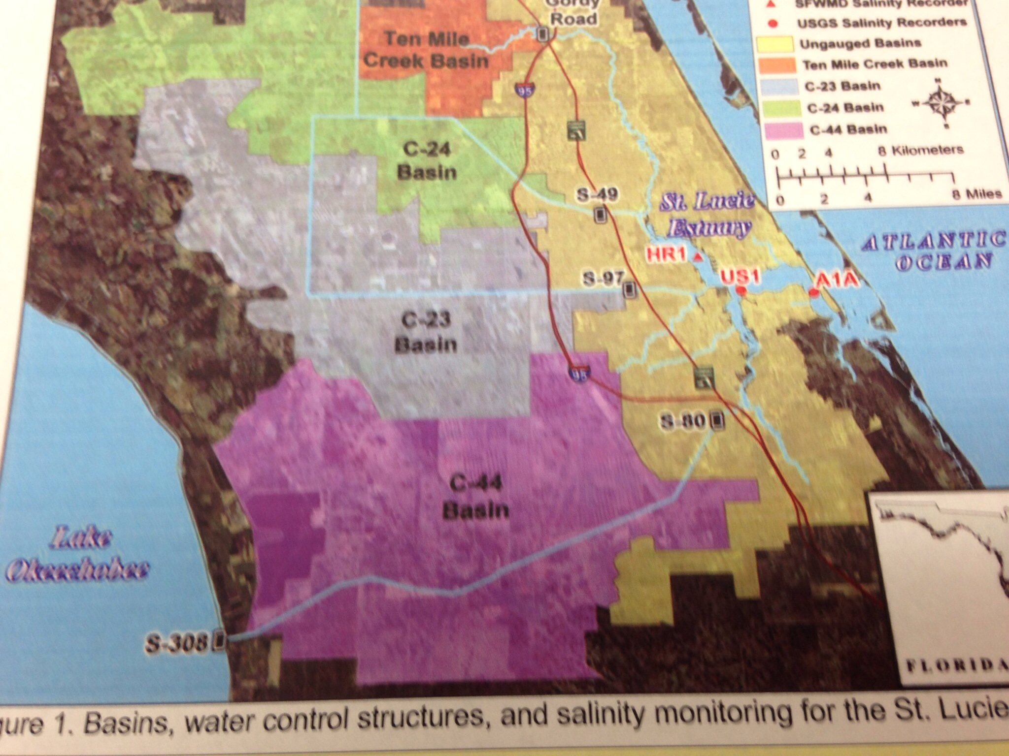
Basins of the St Lucie River.

Something the every day person may not know because the communication feedback loop between state agencies and the public doesn’t really function, is that in 2002, the Department of Environmental Protection, a state agency, declared the St Lucie River, part of the southern Indian River Lagoon, “impaired.”

The 2002 report reads: “Anthropogenic impacts to the St Lucie River have impaired its function as an important estuarine ecosystem and resource. Stream channelization, wetland drainage, conversion, construction of drainage canal systems, urbanization, and agriculture activity have so completely modified the watershed that it can no longer function as a healthy ecosystem…although it was once one of the most productive in the world…” (http://www.dep.state.fl.us/southeast/ecosum/ecosums/SLE_Impairment_Narrative_ver_3.7.pdf)

A tremendously loss to say the least. Why did we have to wait until it was dead to do something?

Unfortunately that is the case, so what’s important to know now about this “impaired” status is that it triggered a program to help the water body called a Basin Management Action Plan (BMAP) and Total Maximum Daily Loads, (TMDLs).

You may have heard of them.

So now that the water body is impaired, there is an action plan for the water basins limiting the total maximum daily loads of nitrogen and phosphorus that flow into the estuary.

Municipalities and counties will be held eventually responsible for the maximum levels of pollutants allowed to enter the water before the water would become “impaired.”

This gets confusing, I know. I think of it like this: how many cigarettes one is allowed to smoke before one is on the verge of dying of cancer…your total maximum daily smoke, before you become “impaired.” But what if you been smoking a pack a day for 80 years? Is there time to cut back? Shouldn’t you just quit?

Crazy isn’t it?

The real catch for the St Lucie River is that much of the water that runs into the river is from Lake Okeechobee through C-44. So even if the St Lucie met its TMDLs they would be destroyed by releases from Lake O.

The state is working on this problem and many others. This might take awhile to fix. They are figuring 5, 15, and 30 year implementations before they can really measure improvements…

Time is of the essence, but this is the best the state can do.

Hmmm…I’m not a smoker but I am so frustrated, I think I’ll go have a cigarette.

Mark Perry, the Voice of the Indian River Lagoon

50 year anniversary Florida Oceanographic Society.
50 year anniversary Florida Oceanographic Society, 2014. Nancy Perry, Jacqui TL, Mark Perry. (Photo Ed Lippisch)

Florida Oceanographic was started in 1964, the year of my birth. When my parents moved to Stuart, I was eight months old. After living with or near my grandparents, the family built a house on Edgewood Drive in St Lucie Estates. As soon as I was old enough to ride my bike, one of the coolest things around was Florida Oceanographic at the mouth of Krueger Creek, where Mr Rand, an eccentric, wealthy businessman lived or had the headquarters to his corporation.

Another part of growing up was going to St Mary’s Church. And as a kid I always looked up to the older kids and two of the most prominent were Mark and Chris Perry. Their parents lived in Snug Harbor and looked like movie stars to me. Mark and Chris were simply “cool,” while I was a little twerp. My mom always told me Mark worked or helped at Florida Oceanographic, this made me pay more attention to the water and research of such.

In time Mark became the head of Florida Oceanographic. I went away to University of Florida and other places for over 17 years and when I returned the new location of the institution on Hutchinson Island was even more compelling. Mark’s leadership had built the institution and given a voice to the Indian River Lagoon and offshore reefs in way never done locally before, inspiring a new generation of people.

To celebrate Florida Oceanographic, is to celebrate the life of Mark Perry. No one has given a lifetime of service to the areas’ lagoon and ocean in the way Mark Perry has. Fifty years later and he remains one of the people I still admire most and feel he has influenced my love and protective attitude towards our local waters; I bet he’s influenced you too. Go visit today and give Mark Perry a bear hug in the name of the Indian River Lagoon!
(www.floridaocean.org)

Aerials, “Never Forget the Lost Summer” St Lucie River/Indian River Lagoon

On September the releases were at their worst.
 Aerial photos of releases at St Lucie Inlet, Sewall’s Point and Jupiter Island at the height of releases from Lake Okeechobee. Area canals were also releasing at this time.  This era became known as the “Lost Summer, as waters were toxic for almost three months and visibly disgusting the two months before. The releases themselves began May 8th and stopped October 21, 2013. (Photos taken in August/September by Jacqui Thurlow-Lippsich and Ed Lippisch )

These shocking photos taken last summer have helped to keep up the pressure on Martin and St Lucie’s counties legislative delegation and others in both Tallahassee and Washington DC for change along water bodies releasing into the St Lucie River and Indian River Lagoon and future hope for future water storage and a flow way south.

Also, the Stuart News and Scripps Newspapers continues to post lagoon article almost every day. The business community, students, and retired, everyday people are still up in arms.

There are  both short and long term goals to save the Indian River Lagoon and St Lucie River, but the public’s collective memory is the greatest hope for a better future as we advocate, partake, and lobby for clean water.

As you go out this weekend and Spring Break begins for our area young people, recall last year’s late spring, summer and fall when the public  could not go out or into  our area waters.

And when you have a chance, call your local, state and federal officials and nicely ask: “How’s it coming with those  water issues,  and when are you up for reelection?”

IMG_8250 IMG_8254 IMG_8256 IMG_8259 IMG_8274IMG_3351 IMG_3361 IMG_7312 IMG_7314 IMG_7421 IMG_7435

C-23 and its Destruction of the St Lucie River/Indian River Lagoon

Bessey Creek in 1965, is the exiting point for C-23 into the St Lucie River. The canal was  built between 1959 and  1961.
Bessey Creek and a newly constructed C-23 photographed in 1965. The creek  is the exiting point for C-23 into the St Lucie River. The canal was built between 1959 and 1961. As development of the surrounding lands has increased so has the pollution from the canal. (Photo archives of Sandra Thurlow)

There are three destructive canals that empty into the St Lucie River/Indian River Lagoon, C-44 built in the 1920s, and  C-23 and C-24, built later, between 1959 and 1961. They all over time have destroyed the health and integrity of the St Lucie River/Indian River Lagoon.

C-23 is the canal that boarders northern Martin and southern St Lucie Counties. It was built by the Army Corp of Engineers as part of the Central and and South Florida Flood Control Project that came into being in a “second” gigantic  round of federal funds invested in Florida after a hurricane and extreme flooding in 1947 because, basically, people had built and started farming in areas throughout south Florida that were wetlands or swamps.  The goal of the canal was to divert waters that would have “gone south,” and possibly even north into the St John’s River to the eastern, coastal waters.  As usual, the ACOE  was very successful at the complete cost of the environment.

Thus the C-23 canal drains a 175 square foot basin that includes parts of Okeechobee and St Lucie Counties that originally did not run into the St Lucie River. Once drained, these lands were primarily developed into citrus groves and other agriculture . According to the Department of Environmental Protection, the “urban land use, at the eastern end of the basin, includes solid waste disposal; light industrial, and golf courses.”

C-23 is a filthy canal. It delivers suspended solids, nutrients, fertilizers, and pesticides such as ethion, norflurazon, simazine, bromacil. Metals such as copper and  lead have also been found in the surrounding sediments with concentrations high enough to “constitute toxicity” to fish, seagrasses,  and other animals. You may recall even recently in the news,  a sheepshead, with a huge pink tumor caught right in this area. DEP (http://www.dep.state.fl.us/southeast/ecosum/ecosums/c23.pdf); Tumored fish(http://martincountytimes.com/fish-with-large-tumor-on-head-found-in-palm-citys-bessey-creek-near-st-lucie-estuary)

My middle school aged niece, Mary, lives across the canal in North River Shores;  she chose to do her science fair project on the C-23 this year and found that the canal had the highest level of phosphorus of the three canals. As she grows up, her generation will be working to fix our and our grandparents’ over zealous accomplishments and mistakes. Although our federal, state and local government claims that we’re “working on getting the water right,” it seems like we could do more and a little faster to help them… 

photo

Killer Gerard Schaefer and the Indian River Lagoon

Blind Creek is located on Hutchinson Island just north of the St Lucie  Power Plant.
Blind Creek is located on Hutchinson Island just northeast of the St Lucie Power Plant, in St Lucie County and is where serial killer and Martin County Sheriff’s officer, Gerard Schaefer, tortured and killed two young women in 1973.

The subject of serial killer, Gerard Schaefer,  is one I certainly never indented to write about, but with Tyler Hadley’s murder trial in the paper every day I am reminded of another terrible murder story that occurred “in  Stuart” along  the Indian River Lagoon, North Hutchinson Island.

When I was  nine years old, growing up in Stuart, a Sheriff  in our county  of 28,000 people was arrested for allegedly killing and torturing two girls on Hutchinson Island. Over time, it was learned he had killed over thirty women in towns  across America. This smiling killer is one of the most atrocious  serial killers of all time. He worked and lived right here; as mentioned, his  name is Gerard Schaefer.

As with Tyler Hadley, it  didn’t make any sense. Schaefer came from a “nice family,” in Wisconsin, was raised Catholic,  graduated from Florida Atlantic University, in Broward County worked as a teacher and in law enforcement, he was married,  his mother also apparently lived with the young couple. As time went on things didn’t go so well in Broward, so he decided to apply for a Sheriff’s position further north in Martin County.

What was even more bizarre for me to grasp in my youth, was the fact that this serial killer’s public defender, Elton Schwarz,  also working in Martin County, ended up marrying Gerard Schaefer’s wife, twenty four years Schwartz’ junior, while Schaefer was in prison.  After divorcing Schaefer and marring Schwartz, the couple was  happily married for thirty years. (The Early Lawyers of Martin County 1925-1965, Thomas Thurlow Jr, 2011.) Schaefer, on the other hand, was murdered by a fellow inmate while in prison in 2005.

The Schafer trail went on for years, long past my high school days, and  definitely tainted my teenage mind.

I don’t know if it made me any more careful, in fact it may have made me more defiant, as I remember jogging along North River Road’s sidewalk at night in Sewall’s Point and being reprimanded by Chief Savini, even brought home; but, I know for sure that it  certainly affected the way I view authority and “the world.”

“Things are not always what you think they are; don’t trust what you see.”

Today most people don’t even remember serial killer Gerard Schaefer, but I think as uncomfortable as it is, it  is important that we do. Presently as Tyler Hadley is on trial in neighboring Port St Lucie, we are faced to confront demons even here along the beautiful Treasure Coast.

And most important, by remembering, there is a  better chance that history will not be allowed to repeat itself.

Link to 2010 story by Stuart New’s Tyler Treadway: (https://www.tcpalm.com/news/2010/nov/28/former-martin-county-deputys-killing-spree-in-of/?print=1) Subscriber link: (https://www.tcpalm.com/news/2010/nov/28/former-martin-county-deputys-killing-spree-in-of/)

The Almost Great “Port of Stuart,” along the St Lucie/Indian River Lagoon

1911 Seawall's Point Land Company map
Portion of 1911 Sewall’s Point Land Company map showing area off of Sewall’s Point and Stuart where the great “Port of Stuart” was being developed.

The headlines of the South Florida Developer on December 29th, 1925 bragged about a Stuart along the St Lucie/Indian River Lagoon very different than the one we know today:

“Port of Stuart, Florida’s New Gateway. “

“The Opening of the St Lucie Inlet to the commerce of the world will bring to Stuart and all Martin County that belated recognition to which it is rightfully  entitled by virtue of its strategic geographic location.”

“W.B. Shearer, recognized international authority on ports and waterways, makes the positive statement that of all the East Coast’s four hundred miles of waterfront, the harbor at Stuart is the the only port with natural advantages suitable for a naval base…”

“St Lucie Ship Canal Locks- the first link in the chain of waterways that will eventually form a navigable canal from the Atlantic  to the Gulf of Mexico is the “St Lucie Ship Canal” now 95% complete. It’s completion will open up the fertile western portion of Marin County…”

As these headlines show, the “Port of Stuart” was not just a dream, in the early 1920s, it was a becoming reality.  Details of the port still exists in dusty federal, state and local documents. If it were not for the Great Depression of the late 1920s and the difficulty for the ACOE in dynamiting the Anastasia rock from the bottom of the St Lucie Inlet, it could have been a reality.

So how could this be? Today an idea like this would be heresy!

Well, Captain Henry Sewall, for which the peninsula of Sewall’s Point is named, was one of many responsible for this “heresy.”  Not only had he led locals  to  open the St Lucie Inlet by hand in 1892, he had served as county commissioner, and state representative. 

In 1910 Captain Sewall and his powerful business friends, including adventurer Hugh Willoughby, founded “Sewall’s Point Land Company,” as Captain Sewall had inherited the tip of Sewall’s Point and large portions of waterfront and other lands along Stuart through his family linage to the famous Miles-Hanson Grant.

According to Sandra Thurlow’s book: “Sewall’s Point, the History of a Peninsula on Florida’s Treasure Coast,” after the formation of Sewall’s Point Land Company, the men got right to work building the Sunrise Inn on Old St Lucie Boulvard, and miles of roads in today’s Golden Gate; (see map above), government, bonds were held by the county and a turning basin at the tip of Sewall’s Point was dredged; this fill created today’s Sandsprit Park.”

A turning basin at Sewall’s Point? You’ve got to be kidding.

They were not.

Even poetry was written for the dream, ironically by beloved environmentalist,  Ernie Lyon’s father: 

Just One Place for the Harbor
by Harry Lyons
1924

“Brave sailors in Atlantic storms, 
A harbor need for aid.
 They skirt the coast of Florida,
Lest commerce be delayed.
When hurricanes sweep o’er the deep,
And ships grave perils face,
‘Tis the duty of all mariners,
To seek an anchorage place.
You’ll find the place for a harbor here,
Where the old St. Lucie flows.
There is room for ships at Sewall’s Point,
Where the Indian River goes.
No where else is there such an inlet,
Down below or up above.
There is just one place for the harbor!
Stuart the town we love!
From Stuart to Fort Myers at last,
We’ll have a waterway,
When the canal is finished,
And they’re hastening the day.
Across Lake Okeechobee,
From the Gulf of Mexico,
Oil and phosphate, fruit and lumber,
Into Stuart soon will go.”

Sewall died in 1925 and the bottom fell out of the real estate market around 1926. Around the same time, two devastating hurricanes put the nail in coffin of the Stuart Port at the St Lucie River and Indian River Lagoon.

It is interesting to note that the St Lucie Canal, C-44, between Lake Okeechobee and the St Lucie River was completed not only for transportation and trade, but for flood control of agriculture and people working south of the lake. The prosperity associated with the canal for the local people of Stuart never came and the canal ended up being a major factor in the destruction of their beloved waterways…

Well time goes on, new dreams come and go; new fortunes are made and lost. But for old times’ sake, one can stand at  Sandsprit Park, and look out to Sewall’s Point remembering  perhaps Stuart’s biggest dream, the lost dream, and for many, a dream well lost, the dream of the “Great Port of Stuart.”

*Thank you to my mother, Sandra Henderson Thurlow,  for sharing her historic articles to make this write up possible.

Inspiration’s Luminescence on the Indian River Lagoon

Morning's Light on the Indian River Lagoon
Sunrise along the Indian River Lagoon, Jensen Beach. (Photo JTL)

light, noun: “understanding of a problem or mystery; enlightenment”

If you have ever had the chance to drive along Indian River Lagoon in the early morning or at sunset, you have probably been taken by it’s light.

No matter how “bad” the health of the river itself can get, at sunrise or sunset, there is the river’s glorious illumination. It’s one of those otherworldly gifts in a life that is often otherwise quite commonplace.

In the new or fading light of the Indian River Lagoon, we are renewed, and find our  inspiration to fight, and to save it.

Tallahassee’s Dolphins and the Sadness of the Indian River Lagoon

Stormsong

The last time I was in Tallahassee was I eighteen and there to cheer on the Florida Gators.Today I was there to visit the Capitol and  the city looked very different with thirty plus years under my belt.

I noticed the city was actually quite beautiful, very southern, with magnificent, awe inspiring oak trees, tall stately buildings, and dolphins.

At the back of the Capitol, which today almost acts like the front of the Capitol, there is a large statue called “Stormsong” composed of stainless steel dolphins. The animals seem to soar joyously in invisible waves.(http://www.floridamemory.com/items/show/17019) The large piece is beautiful.

The statue is by Hugh Bradford and is a “celebration of Florida’s wildlife.” A public private partnership, from Florida’s  Bush administration, that was started in 2000 and completed in 2008, made the work possible.

As breathtaking as the statue is, I could not help but be saddened knowing that the dolphins who live in my home town of Sewall’s Point in Martin County are probably the sickest in the state. These dolphins suffer from suppressed immune systems, multiple sicknesses and more than anywhere else, lobomycosis. This has all been written about and documented by Dr Gregory Bossert previously of Harbor Brach Oceanographic Institute. His research states that it is believed the filthy fresh water releases from Lake Okeechobee exasperate an already toxic water system in the southern Indian River Lagoon.
(http://avmajournals.avma.org/doi/abs/10.2460/javma.228.1.104)

On top of this the northern and central lagoon has had a UME or “unexplained morality event” since 2013 and over 90 dolphins have died, “mysteriously.”
(http://www.nmfs.noaa.gov/pr/health/mmume/floridadolphins2013.html)

It is time for the Capitol’s politicians to look deep within themselves and out the widows and start working for the irreplaceable wildlife in our state instead of against it.

Pioneer Churches Still Praying for the Indian River Lagoon

Stained glass windows from St Paul's Episcopal Church of Eden, later St Paul's' Church of Walton, now at St Mary's Church, Stuart. (Photo Sandra Thurlow)
Stained glass windows from St Paul’s Episcopal Church of Eden, later St Paul’s Church of Walton, now at St Mary’s Episcopal Church of Stuart. (Photo JTL)

According to my mother’s book, Historic Eden and Jensen on Florida’s Indian River,  there were a  number of pioneer churches along the Indian River Lagoon.

One that strikes a special cord for me is St Paul’s that was built in 1898 but destroyed in the hurricane of 1949 as pictured below. (Photo courtesy archives of Sandra  Henderson Thurlow.)

scan0025 (3)

Thankfully the stained glass windows were saved, and today they are the backdrop for the altar at St Mary’s Episcopal Church in Stuart that was built in 1949, the year of the storm.

According to My mother’s Jensen/Eden book,”there were no churches for the earliest settlers of Jensen and Eden to attend,” but it was the African American community of Tick Ridge, along Savannah Road, that built the first in 1890. This church eventually took on the name “St Peter’s African Methodist Episcopal Chapel,” and is located between the Savannas and the Indian River Lagoon. A newer church, a CME, or Christian Methodist Episcopal Church, stands on the same location today.

A second church rose in 1899, also in Tick Ridge; it was baptist in denomination.

In 1898 the beautiful All Saint’s Episcopal Church and Cemetery (http://en.wikipedia.org/wiki/All_Saints_Episcopal_Church,_Waveland_(Jensen_Beach,_Florida)  was built, still stands today, and is the oldest longstanding church in the area according to its Wikipedia write up; this is the church that can be seen on the west hill just north of Rio when traveling on Indian River Drive.

In 1903 the Eden Union Congregational Church was built and is still standing in old downtown Jensen; it the one with the really cool concrete blocks and once was painted bright yellow; and finally, the Community Church of Jensen was organized in 1938,  eventually moving to its stunning and “heavenly” location on one of the highest sites in the county, Skyline Drive, Jensen Beach. 

In the hard times of Eden/Jensen pioneers, people set priorities and organized to worship. In one form or another, most of these churches are still standing today. What an accomplishment to the spirit of the men and women who built and loved our area and have passed on.

I believe with out a doubt, they’re all still praying, and and thank God they are, because we all know, the Indian River Lagoon needs nothing short of a miracle!

All on Board for Fertilizer Ordinances-Indian River Lagoon

The River Kidz protest HB 421, Fertilizer Preemption, in 2011, Town of Sewall's Point. (Photo Nic Mader)
The River Kidz protest Florida HB 421, that would have preempted the fertilizer ordinance of Sewall’s Point. (Photo Nic Mader, 2011)

Fertilizer has certainly been a hot topic over the past few years and for me this movement is one of the great hopes that the Indian River Lagoon has a chance of surviving.

Fertilizer ordinances, specifically those with “black out periods,” started on the west coast of Florida over a decade ago as activist around Tampa Bay and Sarasota decided to fight for their waters. They have had great success after great losses and now Tampa Bay has more sea grasses than it did before World War II, due mostly to its BE FLORIDAN program that the National Estuary Program is now trying to bring to the IRL. (http://www.befloridian.org)

Although there had been talk years ago of fertilizer ordinances on Florida’s east coast, they really didn’t  catch on until  the Town of Sewall’s Point adopted a “strong” fertilizer ordinance, a “black out period,” or no fertilizer use during the rainy season (June-November, for SP)  in 2010. I am proud to say I was a big part of that movement with the support of the Sewall’s Point Commission.

It was Commissioner, to be Mayor, Jeffery Krauskoph, in 2009, who gave me the idea to push for such an ordinance in the Town of Sewall’s Point. The City of Stuart had actually passed the first in the area, however;  it did not have a “black out period” and the Sewall’s Point ordinance does.

Ironically, last night the City of Stuart was petitioned by fertilizer activists from Volusia, Brevard, Indian River, St Lucie and Martin counties to push for a “stronger” fertilizer ordinance and Stuart in fact adopted, by first reading, the Martin County ordinance, a “strong” fertilizer ordiance.

The perils of fertilizer were first majorly documented in  the research of the National Reasearch Council’s, Clean Coastal Waters, Understanding and Reducing the Effects of Nutrient Pollution, in 2000. Dr Brian LaPointe and and Dr Margaret Leinen of Harbor Branch Oceanographic Institute both sat on this national committee and Dr Leinen even testified before Congress. (http://www.nap.edu/catalog.php?record_id=9812)

The book scientifically states ” the problems caused by nutrient over enrichment are significant and likely to increase as human use of inorganic fertilizers and an fossil fuels continue to intensify.” The scholarly publication notes strategies for “control” and tells the story of synthetic fertilizers created after World War II and how they transformed not only agri-business but suburbia, and how this, hand in hand, with over development, has lead to the steady demise of our beloved coastal estuaries. In many cases, such as the Gulf of Mexico, fertilizer from farms along the Mississippi River have created “dead zones.”

I am on the board of Harbor Branch’s Foundation and I once asked Dr Leinen, (who now is now the Vice Chancellor for Marine Sciences and Dean of the School for Scripps Institute of Oecnograpy in California,) “if you testified before Congress on this problem, why didn’t they listen; why didn’t they do anything? ” She smiled at me and kindly and replied, “Jacqui, politics often overrides science.”

I stood there and had one of my “realizations…”

On a positive note, what  I love about fertilizer ordinances the most, is that the “people” have embraced them as they realize the fertilizer problem is something they can directly and positively affect. As the public puts “skin in the game” for the direct benefit of their rivers, springs and estuaries, they expect this of their politicians as well. This is the  beauty and and power of fertilizer ordinances; it is politics on its most revolutionary level, that of “the people….”

At this time, “strong” fertilizer ordinances have been adopted in the Town of Sewall’s Point; Martin County; Indian River County; St Lucie County;  Orchid Island; Indian River Shores; Vero Beach; Brevard County; and are at first reading or being “worked on or discussed” in Stuart; City of Port St Lucie, Jupiter Island; Ocean Breeze; Fellslmere; Palm Shores; Melbourne Beach; Sebastian; Rockledge; Satellite Beach; New Smyrna Beach; Cocoa Beach and most likely a handful of others. Marty Baum, the Indian River Keeper, and others to be commended for taking the time to travel and advocate.

Like wildfire, communities along the Indian River Lagoon are taking into their own hands a part of the puzzle to save their lagoon. And the dolphins, manatees, seagrasses and and fish are smiling and hoping that this is just the start! As Dr Grant Gilmore said at the 2013 Harbor Branch Symposium, “it is the people, not the government, that will save the IRL.”

The Black Bobcats of the St Lucie Region and Indian River Lagoon

Melanistic bobcat caught in Martin County (Photo Busch Wildlife Center)
Captured melanistic bobcat from Martin County (Photo courtesy of Busch Wildlife Center, 2007) 

The Martin County Difference” is an expression that one often hears from locals that means exactly what it says, “things are different here…”

Not only are the different, they are exceptional. We have the beautiful St Lucie River and Indian River Lagoon, a four story height limit, a strong urban service boundary, great public schools,  a strong fertilizer ordinance, public beaches and black bobcats…

When I was a kid growing up in Stuart, one sometimes heard stories from the kids that lived in Indiantown or Palm City about “black panthers.” And someone who had seen them would swear on their mother’s grave this to be true. Supposedly these stories had been around for many, many years coming down from parents and grandparents.

More recently in 2008, my first year on the Sewall’s Point commission, the town had  at least  three “normally colored” bobcats and multiple kittens. The sightings were very exciting but scared some residents who had moved here  from up north so I started reading about bobcats in great detail. Eventually we had Dan Martinelli of the Treasure Coast Wildlife Center speak before the commission and things calmed down but my fascination with these beautiful creatures did not.

I talked about bobcats a lot during this time and in the course of a discussion, one of my husband’s physician friends who lived in Palm City, with great excitement told a story of  seeing a black bobcat in Palm City walk across his yard. That same year one of the Guatemalan landscape workers in the town, knowing I loved animals, struggled wide eyes to tell me about the black panther he had seen walking along a fence, close to Lake Okeechobee and the St Lucie Canal, that he had seen while fishing with his son.

According to my reading there have been more reports of melanistic bobcats in Martin County than anywhere else in the country, mostly near the area of the St Lucie Canal, Lake Okeechobee and Loxahatchee.

If you want to find these reports, google “melanistic bobcats martin.” These posts are not entirely scientific but they are documented. They say there have been sightings for the past 80 years.

Although I never seen a black bobcat, popular lore says the exist, I believe it, and it’s certainly better documented than Sasquatch who many of my high school friends claimed to see too.

What an incredible place to live! The “Martin County Difference!”

__________________________________________________________________

According to the Florida Wildlife Commission black panthers  do not exist  but black bobcats do!

FLORIDA PANTHERS:(http://www.fws.gov/floridapanther/panther_faq.html) 

FLORIDA BOBCATS:(http://myfwc.com/wildlifehabitats/profiles/mammals/land/bobcat/)

The ACOE’s “Periodic Scientists Call” and the Indian River Lagoon

S-80, Connecting Lake Okeechobee to the St Lucie Canal or C-44
S-80  connecting Lake Okeechobee to the St Lucie Canal or C-44 controlled by the ACOE. (Photo JTL)

“Who controls the past controls the future. Who controls the present controls the past.” George Orwell 

I used to think it was the Colonel of the Army Corp of Engineers who single handedly had control to open the gates at S-80 and S-308 to allow the waters  of Lake Okeechobee to flow into the St Lucie River, Indian River Lagoon. (http://www.saj.usace.army.mil/Missions/CivilWorks/LakeOkeechobee.aspx)

But since February of last year,  I have gotten more insight.

As an elected official, I am allowed to sit in on the Army Corp of Engineers “Periodic Scientists Call” that occurs about once every two weeks.  Last year I was invited to sit in with Martin County and I have attend ever since.

No experience has helped me understand the south Florida water process as much as  consistently sitting in on these calls.

The call is a meeting of the scientific stakeholders to give their input to the ACOE before the Corp makes  its “guidance” for Lake Okeechobee, and usually the following Thursday, after, meeting with the SFWMD,  a “recommendation.”

As you can imagine,  the call is run by the US Army, so it  is very systematic and the language is filled with acronyms and science jargon. For the first six months, I was basically a silent  idiot listening to a foreign language. But slowly I have been catching on.

Thankfully some things are totally predicable. For instance, every call the first thing that is accomplished after reading the rules of the call, is that  the roll call is taken. I like to listen to who is there: ACOE? Florida Fish and Wildlife Commission? City of Sanibel? Ft Meyers? Martin County? St Lucie County? NOAA? Florida Dept. of Environmental Protection?  Florida Department of Agriculture and Consumer Services? SFWMD? Broward County? Highlands County? Osceola County? Tribal Nations? Lee County? Ding Darling? Congressmen and other elected representatives? Members of the public? Other?

Then a leader from the ACOE  gives a short power point presentation that reviews rainfall; precipitation outlooks by the SFWMD and NOAA; Lake Okeechobee inflows and outflows;  operational band standing; SFWMD position analysis; Lake Okeechobee Regulation Schedule (LORS); and then finally a “guidance” for a “decision.”(http://www.saj.usace.army.mil/Media/NewsReleases/tabid/6071/Tag/2128/lake-okeechobee-regulation-schedule.aspx)

Next, each stakeholder, one at a time, gives an update on their specialty and makes their case for their interest. Public members are then allowed to speak and and the again the ACOE leader goes through everyone one more time to see if if anyone has  new comments based on the other just shared.

The calls are scientific and unemotional. However, there times of tension and difficulty like last year when the ACOE began releasing to the St Lucie River, Indian River Lagoon and Caloosahatchee on May 8th and continued steadily, then intensely, through September 21, 2013. This tension may start up again soon, as the lake is higher than they wish for this time of year and it has been a wet winter. The “decision” should become public today.

I have to say that after sitting in on all these calls, the Army Corp often holds back when the LORS chart, and maybe even the SFWMD, says to “release.” But in the end, the inevitable occurs.

Although I appreciative of the hard working men and women who run the ACOE, I do think the overall system fails to take into account the long term survival needs of the natural system which includes “us,” and favors the security of resources of the sugar industry and agriculture south of the lake.  It is easy to fall back on  “flood control” each time the lake rises, and dump east and west, but the system is more far reaching and has greater demands than just that. The water they are dumping, 1.7 billion gallons on average a day, is simply wasted due to an outdated system. (FOS, Mark Perry)

On a deeper level, the intertwined culture of the SFWMD, the ACOE and agriculture, especially the sugar industry, is one going back over 100  years. Their connection runs deep and is a cultural one, one that has allowed them to control water and politics for their own interests in South  Florida, past and present.

But times change and world views evolve. Personally, I am pushing for a future  a little less Orwellian, and a little more respectful, of our natural resources and Mother Nature.

Sugar, the Indian River Lagoon, and the Changing Hurricane Winds of 1928

Historical marker of mass burial site, 1928 hurricane, Indiantown, near Port Mayaca. (Photo by Evie Flaugh)

Historical marker of mass burial site for  Florida’s 1928 hurricane, near Port Mayaca, Indiantown. (Photo by Evie Flaugh)

If you drive west from Stuart, on Highway 76  towards Port Mayaca,  you’ll eventually see a large graveyard on the left hand side of the road. It is well kept and reminiscent of an old Florida, a Florida of pioneers, the Klu Klux Clan, and the Indian Wars. Large oak trees line the property and the unusually massive grave stones stand like sentinels to a time long past.

At the entrance is a memorial sign dedicated to the approximately 3000 people who were killed in the Florida hurricane of 1928. An earthen dike, barely holding back the waters that had naturally flowed south for thousands of years, breeched, killing mostly black agricultural migrant workers, while flooding sugar, vegetable farms, and personal property built in the  path of the natural flow way south of the lake. Thousands of bodies were  laboriously  buried in mass graves, one in Martin and another in Palm Beach County. (http://www.srh.noaa.gov/mfl/okeechobee)

African American, Etonville writer, Zora Neale Hurston, http://en.wikipedia.org/wiki/Zora_Neale_Hurston) writes in her classic novel, Their Eyes were Watching God, about migrant workers “looking back” as they were running to escape the furry of the 1928 hurricane. 

“Above all the drive of the wind and the water…and the lake. Under its multiplied roar could be heard the almighty sound of grinding rock and timber and a wail….people trying to run in raging waters and screaming…The monstropolous beast had left his bed. The two hundred miles an hour winds has looses his chains. The sea was walking the earth, with a heavy heel.”

All work for blacks during the late 1920s was difficult and filled with the prejudice and hardship of the Jim Crow Laws. In the sugar industry  there were complaints of “controlling” black harvest labor, aided by law enforcement, debt peonage, forced labor and even killings.

Today when people speak about the hurricane of 1928, the death of the workers south of the lake is credited as the source for pushing for “flood protection.”  This is not full disclosure. 

The truth of the matter is that the storm was also an opportunity for the struggling sugar industry, south of Lake  Okeechobee, not only to “protect” their poorly treated laborers, but to rally local, state and national government officials to support legislation to “invest” in  the area against future flooding for the benefit of their fields, and the future riches of the industry.  (Source Raining Cain in the Glades, Hollister, http://www.press.uchicago.edu/ucp/books/book/chicago/R/bo5704198.html)

This was no easy feat and insanely expensive in a time around the U.S. Great Depression. Politicians and businessmen were creative and put emphasis the  Okeechobee Waterway for “navigation, “rather than focusing solely on “flood protection.” At the time, navigation funds were much easier to get from the federal government than funds for “drainage” or flood control of the newly created Okeechobee Flood District.

These funds came to fruition in the construction of the  “Cross State Canal,” also known as  the “Okeechobee Waterway, “which links the Caloosahatchee River to Lake Okeechobee,  to the St Lucie River and Indian River Lagoon and conveniently doubles as a giant drainage canal for the sugar industry, diverting as much a 92% of the flow of water south of Lake Okeechobee.  

You may have seen an arch in Rio that says “Gateway to the Atlantic.” That arch was built in celebration of he Cross State Canal…

Local people at the time had no of idea the greater repercussions of such to their greatest local resource, the St Lucie River, Indian River Lagoon. We still sit open mouthed today when S-308 at Port Mayaca is opened by the Army Corp of Engineers, and our area’s river resources are destroyed. Certainly we have our own local canal and runoff problems, but Lake Okeechobee’s tremendous waters, all the way from Orlando, are most destructive. 

It’s exhausting. The Cross State Canal was completed  in 1937, and we in Martin County have been fighting ever since, the changing winds of Florida’s hurricane of 1928. 


Florida’s Legislative Session, How Can it Work for the Indian River Lagoon?

"Save our River," River Kidz FDOT recycled art sign, now in Washington DC, office of Congressman Patrick Murphy. (Photo JTL)
“Save our River,” River Kidz FDOT recycled art sign, now in Washington DC, office of Congressman Patrick Murphy. (Photo JTL)

After six years as a locally elected official, one thing is clear. I still do not really understand how the Florida Legislature works or how to make it work for me, but I’m getting there.

I thought with the Legislative Session convening, today, March 4, 2014, I would try to share what I do think I know or what I think I have figured out.

First of all, the basics. The legislature is composed of two “houses:” the House, that consist of 120 members http://www.myfloridahouse.gov

and a  Senate, that is composed of 40 members http://www.wikipedia.org/wiki/Florida_Senate. Each represents a district according to population.

The House leadership includes Speaker of the House; Speaker pro tempore; Majority Leader; Minority Leader and committee chairs. These House seats come up for reelection every two years. Not fun.

The Senate leadership consist of the President of the Senate; President pro tempore; Majority Leader; Minority Leader and  committee chairs. Senate seats come up for reelection every four years, so you can at least get something going before you have to jump back into the reelection circus.

There are term limits for both the house and the Senate but because they are defined as “consecutive” you can take a break and then jump back in….

So what have they been doing? Well, recently they have been in Tallahassee and had “House and Senate Interim Committee Meetings.” The dates of those meetings were as follows:  September 2013, 23-27; October 7-11; November 4-8; December 9-13;  January 2014, 6-10; 13-17; February 3-7; 10-14; and 17-21.  So what do they do at these “interim meetings?” In their committees they formulate the bills that individuals will sponsor and try to get passed starting today, March 4th, when the session officially begins. This year the last day of session  is May 2nd.  So it is two months of “mayhem …”

A bill can start in the House or the Senate but it has to have a “companion bill” to move forward and be voted upon. Hundreds of bills are brought before the legislature each session but only a fraction will make it into law. You can imagine there are many different interest throughout our varying state…

As the session continues, it is difficult to keep track of everything and bills usually get packaged along with others, sometimes with others that have nothing to do with them. As a locally elected official, this frustrates me as I feel every bill should be considered separately as local ordinances are. Well, this is not the case, and allows for negotiating– better said, “if you help me, I’ll help you,” which at the end of the day is not so bad. What is bad, is that the people, the voting public, have almost no way of keeping up with all this hop-schotching, so we are 100% dependent on our elected officials and those watching out for us at home. To complicate issues further, elected officials are pressured, and blackmailed, mostly by their own party, to do what they need to do to make a deal work or “we won’t let your bill be heard” or “you’ll never get to chair a committee,” especially if you are a freshmen or relatively new to the pecking order.

It takes years to develop the seniority to do what you want, so to speak. Senator Joe Negron http://en.wikipedia.org/wiki/Joe_Negron a good example, as he served in the House before he served in the Senate, then he became the head of the Appropriations Committee (they all sit on committees in some capacity ) and his recent  position has a lot of influence and power. Senator Negron could not have started the “senate Select Committee on the Indian River Lagoon and Lake Okeechobee” years ago; he has earned his position to do such.

So how do you stay on top of all this  politicking ? It  is kind of like holding an angry cat. Hold on tight but be prepared to get scratched. Go on line to the state website and get on email alerts and call your local delegation: here in Martin, St Lucie and Indian River: Senator Joe Negron; Representative Gayle Harrell and Representative Mary Lynn Magar; Representative Debbie Mayfield; Representative Larry Lee,  and tell them you expect them to support  St Lucie River and Indian River Lagoon policy and whatever else is important to you; tell them you appreciate what they are doing, and that you are paying attention to reports in the newspaper as far as how they vote. Most of all, be supportive so they support you. And be sure to tell them “good luck not getting scratched.”

Cinnamon Toast and the Indian River Lagoon

The Ship and the Oak Tree
The Ship and the Oak Tree (Photo JTL)

In the late 1960s, one of the best things about Christmas, was that old Christmas trees reinforced our fort under the old oak tree, we pretended was a ship, along the St Lucie River.  I remember going to my neighbors, the Schramm’s house, with all their brothers and sisters, to have cinnamon sugar toast for breakfast around this time of year.

Mrs Schramm’s cinnamon toast was like nothing I had ever had: butter, sugar and cinnamon on Wonder Bread toast. Delicious! Little did I know, that one day I would be criticizing  the sugar industry for not doing enough to help us save the Indian River Lagoon.

Recently, I have been reading the book, Raising Cane in the Glades,  The Global Sugar Trade and the Transformation of Florida, by Florida International University professor, Gail M. Hollander. http://www.press.uchicago.edu/ucp/books/book/chicago/R/bo5704198.html

The book is credited as the first “to study the environmental transformation of the Everglades within the economic and historical geography of global sugar production and trade.” It is an “environmental history,” a discipline that is becoming more studied and written about: how we as humans effect change in our environment.

The book’s history is amazing and so far the story that has hit me the most is one about Mr Bohr Dahlberg who in the late 1920s owned Southern Sugar Company  before it went into “receivership” and was purchased by Stewart Mott who created the United States Sugar Corporation. http://www.ussugar.com/downloads/ussc-history.pdf

Although Mr Dahlberg’s  company went broke by 1928, the year of the great hurricane, he managed to break the Democratic hold on the “South” and form relationships with Republicans across the country for the benefit of the sugar industry in South Florida by supporting the successful presidential campaign of Herbert Hoover. Mr Hoover was a man who came to the support of those who had supported him, and it is he who authorized the building of the Herbert Hoover Dike around Lake Okeechobee, to protect the sugar industry’s lands and the labor. The dike was completed in 1933 and changed forever the fate of the Everglades, the St Lucie River, and the Caloosahatchee River.

The politics of this book will make your jaw drop. Expressions such as: structure of the world system, national and global importance for presidents, national interest and world unrest, supposed and real issues of national security, using drainage and navigation to nationally fund the Okeechobee Flood District, the Army Corp of Engineers, the  Cross State Canal that opened up the major draining of Lake Okeechobee into the St Lucie River/Indian River Lagoon.

All of this happened thirty years before I ate that cinnamon toast at the Schramms; there are fifty more years of politics that have come into play since then!  The whole thing is rather daunting, but whether a kid, or a 50 year old today, I think the Sugar Industry owes the St Lucie River/Indian River Lagoon something, after all we take their drainage and I ate all that toast as a kid.

Nathaniel Reed, Nature’s God, and the Indian River Lagoon

Nathaniel Reed, in a moment of refection, Rivers Coalition meeting 2-27-14.

Mr Nathaniel Reed is one of those people I have always admired and who has always been “bigger than life,” in my life. http://www.aapra.org/Pugsley/ReedNathaniel.html

His name came before me like sunshine throughout my youth, as someone from little Martin County, who was fighting against the “big guy,” big development, destruction of Florida’s paradise, on a local, state and national level. Someone helping our Indian River Lagoon and St Lucie River.

On the other hand, his family developed Jupiter Island so there was a balance or an irony to the big  picture. Such is life.

Over time, words like these, written by Mr Reed, in his early career, formed the basis of my world view:

“I suggest to you that the American dream, based as it is on the concept of unlimited space and resources, has run aground on the natural limits of the earth. It has foundered on the shoals of the steadily emerging environmental crisis, a crisis broadly defined to include not only physical and biological factors, but the social consequences that flow from them. The American dream, so long an energizing force in our society, is withering as growing social and ecological costs generated by decades of relative neglect, overtake the economic and technological gains generated by ‘rugged individualism’. The earth as a place to live has a limited amount of air, water, soil, minerals, space and other natural resources, and today we are pressing hard on our resource base. Man, rich or poor, is utterly dependent on his global life-support system.”

Yesterday, at a Rivers Coalition meeting, Mr Reed said he had failed in two things in his long successful environmental career. He said he has failed to limit phosphorus going into Lake Okeechobee, and that he had failed to convince others of the importance of getting  the water going south, the basic principal of restoring the estuaries and the Everglades.

He then relayed to a crowd over two hundred that the flow-way south to the the Everglades, Plan 6, was unfeasible because the sugar industry is the richest industry in the U.S. and they would block anything put before Congress to do such and the costs of the project is too much. He recommended working on a plan that would move the water southeast, through canals, into an enormous reservoir, and letting is seep southward…

I adore Mr Reed, and he will always  be a hero of mine. He looked down yesterday, and confided, that he is in “the final inning “of his life and wants to resolve this water issue before they take him out “fighting..”

Mr Reed is exhausted; he wants success in his lifetime. Of course he does.

But personally, I think to go “around the sugar industry” is perhaps not the answer as the sugar industry has a moral obligation to help with this whole debacle.

Although I respect Mr Reed’s recommendation, as Americans we must remember that sometimes it becomes necessary to “dissolve the political bands which have connected one to another, and to assume among the powers of the earth,  that which the Laws of Nature and Nature’s God entitle us…”

The Indian River Lagoon, an Overview Effect

Earth from Space
Earth from Space (Photo credit, NASA)

This past Tuesday, my father invited me to Kiwanis to listen to a very special speaker, Captain Edgar Mitchell, astronaut, Apollo 14, who is now 83. http://www.noetic.org/directory/person/edgar-mitchell/

The room at Manero’s in Palm City was packed and right off the bat, Captain Mitchell spoke  on his experience in space referred to as the “overview effect.” The overview effect is defined as a cognitive shift in awareness often experienced by astronauts while in space. Mitchell spoke about an experience on the “ride home” as he looked at the floating earth and moon, where an understanding of  life’s broader consciousness “hit him.”

“Seeing the earth in space as a tiny, fragile, ball of life…a pale beautiful blue dot,” changed him forever.

Mitchell returned home, retired from NASA and within one year founded the Institute of Noetic Sciences to study the science of “consciousness.” http://www.noetic.org

Mitchell was not alone in his experience as many astronauts described a similar feeling. They went on as changed men,  as men who went back to the world with a message, a message that in our language and culture is restricted to being called a “spiritual message.”

Captain Mitchell’s message in the crowded room of Manero’s in Palm City, Florida was that we as a species have to change our ways, and how we treat nature, or we will destroy all we have, including ourselves. He said we have have to start “saving the plant instead of consuming it.”

The crowd was slightly amazed, and seemed more interested in the safety of questions about what it was like to set foot on the moon, physically. Nonetheless, I believe the crowd left changed as well.

On my way home, I drove over the Palm City Bridge and nodded to the great St Lucie River, part of our Indian River Lagoon. “The time is coming.”  I said to the river.

It is time, and it has been time, to save it.

St Lucie River, Indian River Lagoon-We’ve Really Mucked it Up…

Muck from the St Lucie River, Indian River Lagoon 2006. (Photo credit, Bob Voisenet,Rivers Coalition)
Muck from the St Lucie River, Indian River Lagoon. (Photo credit, Bob Voisinet, Rivers Coalition, 2006)

It has been described as “black mayonnaise,” and if you’ve ever stepped into parts of the St Lucie River or Indian River Lagoon it may have sucked you down, like quicksand. Muck is as deep as 12 feet or more in some areas and is one of the primary reasons that the St Lucie River, part of the Indian River Lagoon, was declared “impaired” by the state of Florida in the early 2000s.

According to the the Department of Environmental Protection, due to the area’s development, agricultural industry and the building and discharge from canals and Lake Okeechobee, muck sediments into the the St Lucie River have increased causing thick deposits to accumulate.

These muck sediments  are contaminated with pesticides, and metals that “may be toxic to indigenous species.”  The turbidity and algal blooms the muck sediments support have contributed to the near elimination of once abundant seagrasses,  decimation of oysters and outbreaks in fish abnormalities. http://www.dep.state.fl.us/southeast/ecosum/ecosums/SLE_Impairment_Narrative_ver_3.7.pdf

In 2004, with the help of then Senate President, Ken Pruitt, Kevin Henderson of the St Lucie River Initiative, published a study for the SFWMD entitled “Final Report: Characterization, Sources, Beneficial Re-Use, and Removal of Marine Muck Sediments in the St Lucie Estuary.”

This extensive and excellent report concluded that there really are no “beneficial uses” for muck. Because of its high salt content  it cannot be used as fertilizer and the cost of transporting it is often “cost prohibitive.”  Nonetheless, based of this study the county and district were able to coordinate the plans or execution  of muck removal from area creeks, such as Poppleton, Kruegar, Frazier and Haney.

For those of you really into this, it is worth noting that slow moving government policies such as SWIM, Surface Water and Improvement Management, CERP, Central Everglades Restoration Project as well as the Indian River Lagoon Restoration Plan, also deal with muck sediment removal.

There is hope, manatees came back to Kruegar Creek once it was cleaned and the muck sediments of some of the creeks went to build brims at Witham Airfield and “lined” the land fill. Mr Henderson’s report is a reference for all of us and the basis for future improvements.

Also,  right now,  in the central lagoon they are very close to getting monies from the state for muck removal in their area due to their area senator, Thad Altman’s involvement on  Senator Joe Negron’s “Subcommittee on the Indian River Lagoon and Lake Okeechobee.”

As depressing as the river situation is,  in the 1970s laws were created to halt destruction of submerged and coastal lands, like here in  Sewall’s Point where once developers and the local government could  just decide to “create a marina or make subdivisions out of mangrove filled spoil islands. It is a slow go, but in some ways we have been, and we are making  progress. 

I’m about mucked out, but in case you’d like to learn more about muck, this Saturday at 10am in Sewall’s Point, the River Kidz are tie-dying t-shirts with river muck and colors. They named their project: “Get the Muck Out!”  Scientists will be speaking; we will be teaching;  and we will be screaming GET THE MUCK OUT! Please join us.

Black Bears of Hutchinson Island, Our Wild Past

Mr Reginald Waters with black bears killed on Hutchinson Island, around 1930.  (Photo credit Sandra Thurlow, Sewall's Point," A History of a Peninsular Community on Florida's Treasure Coast"/Reginald Waters Rice)
Mr Reginald Waters with black bears killed on Hutchinson Island, around 1930. (Photo credit Sandra Thurlow, Sewall’s Point,” A History of a Peninsular Community on Florida’s Treasure Coast”/Reginald Waters Rice)

When I was a kid, I had a favorite stuffed animal; he was orange bear with blue eyes and his name was “Beary Bear.” I carried him around until his eyes fell off and my mother sewed new ones back on. Over the years, all of his fur came off  so he was bald.

There wasn’t a whole lot “to do” growing up in Stuart in the 1960s and 70s so a kid had to rely on the freedom of empty lots, friends, and  his or her imagination to have any fun.

Before dinner, I used to climb to the top of a giant cedar tree in our back yard and look at the ocean and Indian River Lagoon from our house in St Lucie Estates, in Stuart. I carried Beary Bear up about forty feet with me and we talked about the black bears out there on Hutchinson Island and how there were just a few secret ones left,  a few Mr Walters and the other pioneers couldn’t catch, and didn’t kill. That was fantasy.

According  to historian Alice Luckhart, the black bear population on Hutchinson Island was completely wiped out by about 1930.  (http://www.tcpalm.com/news/2012/feb/03/historical-vignettes-when-bears-roamed-hutchinson-/)

Before modern man came and planted bean fields and produced honey, the bears ate turtle eggs, palmetto berries and the riches of the Indian River Lagoon and St Lucie River. But they they became a problem, so we “wiped them out.”

Isn’t it amazing to think of where we  really live? A land where not too long ago a panther may have swum across the St Lucie Sound;  or a black bear happily frolicked along the Indian River Lagoon? Where fish were so plentiful they kept you awake at night. What I don’t understand is why we “wiped them out.” I guess times were harder then and the mentality was 100% “man over nature” but it’s fun to imagine what it would be like if we hadn’t killed them all,  or somehow, we brought them back.

Well, Beary Bear is long gone, and the bean farms have been replaced with million dollar homes and unimaginative condominiums. But I still have my imagination and somewhere out there, there’s a bear;  I’m sure of it.

Beach Re-nourishment vs. Mother Nature

Homes and Condos at Sailfish Point compromised by beach erosion-with newly constructed seawall, 2-12-14
Homes and Condos at Sailfish Point compromised by beach erosion-with newly constructed seawall and birm, 2-22-14.   (Photo JTL)

The trucks come in about once a year and dump millions of dollars worth of tax payer sand on Martin County beaches and other’s throughout our state. Then winter’s storms arrive and wash it back into the ocean, covering and damaging our nearshore reefs. But at least the turtles have a place to lay their eggs…?

Erosion is a natural part of all coastal barrier islands, in fact, time lapse photography would show these islands moving, like giant sea slugs, changing shape, due to  erosion and accretion, over time.

However, it is mostly the man made inlets that change the erosion pattern along our beaches and cause the issues we have today. http://martincountycoastal.org/program_projects.html 

Before modern man settled this area, inlets along the Indian River Lagoon came and went with the whims of Mother Nature. Looking at old maps, one sees documentation of changing  natural inlets over time. Jupiter and Indian River Inlet north of  Ft Pierce were the only long standing opening to the sea in our area most recently. Over thousands of years, others came and went, all along the lagoon. Peck’s Lake in Martin County broke through as recently as 1960 and was quickly “closed…” 

In 1892 in today’s Martin County, then Dade, Captain Henry Sewall’s inspired local men to dig a permanent inlet, by hand. My historian mother has  told me stories of other inlet attempts as well. According to her, one time, the men fell asleep after the exhausting dig, only to awake and find the tide coming in, filling in their work! One local’s pet raccoon was tied to a tree and taken away by the strong waters. Even today, Mother Nature want’s to fill back in the St Lucie Inlet, but we continue to resist her.

Very interesting is that “old maps” also show Jupiter Island on equal “terms” with Sailfish Point. But today Jupiter Island is much “further back” as she has eroded over time and been slowly swept into the sea. This remains an problem of enormous proportions today that is on the verge of law suit. Last year, the Army Corp of Engineers informed Martin County they wish to take the lovely textured, offshore sands of Stuart, to re-nourish,  Dade and Broward Counties beaches. Unbelievable…

The inlets give us access to the ocean, they raise the value of our property, they were and could be again national defense.  Most timely for today, in the case of the St Lucie Inlet,  it allows the putrid waters slugging forth during rainy season from C-23; C-24 ; C-44; and worst of all from Lake Okeechobee, to go to sea.

There are those who believe we should let the inlet close up;  and there are many who believe we should fill in the canals; there are those who believe the inlet is what defines Martin County and we should do everything to keep her open. Hmm…

One thing for sure, fighting Mother Nature is a full time job.

Remembering Mangroves, the Walking Tree to Wetlands

Evie Flaugh balances her way through a mangrove forest, 2012. Martin County. (Photo credit Jenny Flaugh)
Young Evie Flaugh, walks through a mangrove forest, 2012, Near Hole in the Wall, Martin County. (Photo credit Jenny Flaugh)

One of the first things I learned about the Indian River Lagoon and St Lucie River as a kid at the Environmental Studies Center and later at Florida Oceanographic was mangroves. Red mangroves had cool arch like roots; white mangrove had a notch on the leaf and a salty back; and black mangrove had weird breathing sucker roots coming out of the ground around the tree and were sometimes very  large. http://www.floridaocean.org/uploads/docs/blocks/22/irl-mangroves.pdf  

I also remember walking with my parents along the beach of Jupiter Island and there were gigantic halloween like remnants of a black mangrove forest coming out of the eroding sands.  I also remember the closed off mosquito impoundments around today’s Marriott, Indian River Plantation, and A1A, along the ocean, drowning the mangroves, many white, and black, that looked like giant dead sentinels, somehow still alive, watching us over-kill our environment and all the little misquitoes.

And today, yes, it seems the red mangrove, more than the others, flourishes. Interestingly enough, before the St Lucie Inlet was opened by hand in 1892, there were not many mangroves along the St Lucie River as it was fresh. But close to the ocean, along parts of the Indian River Lagoon, there was brackish water and  there were mangroves.

My historian mother recently told me she attended a lecture of  fish scientist, Dr. Grant Gilmore, and he was of the opinion we needed to create, restore more wetlands and fewer mangroves (as they were destroyed by mosquito impoundments) as the wading birds and many fish rely on this habitat, not just mangrove habitat.

His 2012 key note presentation at Harbor Branch Oceanograpic Institute Symposium is summarized here: http://indianriverlagoon.org/pdf/IRLS%202012%20Abstracts%20of%20Presentations.pdf

In closing this short reminiscent piece, one other thing I remember about being a kid growing up in Martin County is the mosquitos! They were brutal at certain times of the year. We would run in place at the bus stop so they couldn’t get us, and my little  legs were always full of bites and scars. I also remember riding our bikes behind the mosquito fogger truck for entertainment…(so that’s what happened!)

Remembering it all, I can empathize why we went to war with the mosquitos, but if we went too far, let’s take a clear-headed walk through the mangroves, and see what we can do…

Sewall’s Point, Tomorrow’s Oceanfront Property?

Aerial of Sewall's Point, C.B. Arbogast Brochure. Photo Clyde Coutant 1946-1949.
Aerial of Sewall’s Point, C.B. Arbogast Brochure. Photo Clyde Coutant 1946-1949.(Photo courtesy of  S.H. Thurlow)

If you have driven through the Town of Sewall’s Point lately you may have noticed houses being raised. Within a short time, a total of twelve homes will have had millions of dollars invested from the US Federal Government as part of a FEMA flood mediation program. Just over  40 percent of Sewall’s Points’ homes are in a flood zone, and many had “repetitive losses,” during hurricanes Jeanne and Francis in 2004.

“FEMA” is a controversial program. Why is the Federal Government giving people in one of the “wealthiest” areas of Martin County money,  so much money, to raise their homes? Well, at the end of the day, it is a business decision for an almost insolvent FEMA. They figure they will save money in the long run by “lifting” homes that historically they have paid so much money “out to.” This is not just happening in Sewall’s Point, it is happening in coastal communities all over the country. In fact the entire state and county flood maps are changing right now: (http://geoweb.martin.fl.us/flood/  or go to http://www.martin.fl.us –then tab Maps/FEMA Flood Maps)

In 2009, Mark Perry, of Florida Oceanographic, shared a paper with me he had written in 1982, the year I graduated from high school: “Coastal Zone Study of Hutchinson Island and Martin County,” which included substantial information on the geological formation of Sewall’s Point. I was struck by his writing:

“Just before the most recent Ice Age, the Wisconsin, which lasted from 100,000 to 11,000 years before present, the sea level was approximately 25-35 feet above the present mean sea level…at that time the sea was  covering most of Martin County except for the Orlando Ridge, Green Ridge, and Atlantic Ridge…” Sewall’s Point is part of that “Atlantic Ridge, so at least its west side was above sea level. Other known areas today that would have been islands in the ancient sea, are parts of Jensen Beach around the Skyline Drive, Jonathan Dickinson Park, and a large area inland adjacent  to the Allapattah Flats.

My mother wrote the book on Sewall’s Point, “The History of a Peninsular Community on the Florida’s Treasure Coast” and I certainly learned, at a young age, that history repeats itself.

Waters rise and fall; civilizations are built and crumble; powerful multibillion dollar corporations become obsolete…

I suppose we can look on the bright side, the good news is that if you live in Sewall’s Point between the Indian River Lagoon and St Lucie Rivers, you may one day be able to deed your great grandchildren ocean front property.

Why “River Kidz” is Different, and Making a Difference

1509780_739521082727667_910170737_n

River Kidz-St Lucie County member, Adian Lewy, 10, speaks at the Clean Water Rally in Tallahassee 2-18-14 as Indian Riverkeeper, Marty Baum, proudly looks on…

River Kidz, a program that was started by two Sewall’s Point fifth grade girls in 2011, now has hundreds of members,  has a workbook, is taught in many private and public schools, and has divisions in St Lucie and Lee counties. Kids have been taught about the environment for years, so why is River Kidz different?

River Kidz is different because it teaches kids how to advocate. River Kidz’ mission is to “speak out, get involved and raise awareness because we believe kids should have a voice in the future of our rivers.”

All the River Kidz do includes “art, action, and advocacy.” Kids create art in the classroom and in public about the Indian River Lagoon, St Lucie River, focusing on its animals, seagrasses, as well as the damaging discharges  from the canals and especially releases from Lake Okeechobee. This artwork is compiled by teachers and parents along with letters the children write and sent, or personally given,  to local commissioners, mayors, policy makers, congressmen and women, state representatives, senators and even the president of the United States.

Kidz learn to speak in public. Last summer in 2013, 11 year old Veronica Dalton, ask if she could speak at the River Rally at the St Lucie Locks. She delivered her own speech in front of 5000 people.

When I was a kid they taught us about sea grasses and seahorses and it was fun; I learned to love the St Lucie River and Indian River Lagoon but today’s children, if they are going to have the river for their children, have to learn early about its  wonders and its issues, environmental and political,  so they are prepared to protect  and creatively save it in the future.

As a former teacher I know, a child likes nothing more than to have a purpose, responsibility, to be trusted. These kids are rising to the occasion and learning at a young age, to write letters to politicians, to speak out in public, “to do” by deploying  oysters and reef balls and to create art to  get their message across. If  this is what they are accomplishing at ten, what will they do in the future?

River Kidz is my best hope for the future.

River Kidz  is a division of the Rivers Coalition: http://www.riverscoalition.org and RIVER KIDZ Facebook.

Fishing-line, Transparent Death

Banded Brown Pelican, Bird Island, died struggling to escape fishing line 2/14
Banded Brown Pelican, Bird Island, died struggling to escape fishing line in the Indian River Lagoon. 2/16/14

Not a fun photo to see, but one that needs to be seen. This brown pelican was found at Bird Island, or MC-2, a well known  bird rookery, just 100 feet off of Sewall’s Point. The bird, like many others, had become entangled in transparent fishing line, and in its struggle actually pulled its foot off trying to escape. Unfortunately,  the line was caught around the metal band as well.

In 2012, when I was mayor of Sewall’s Point, I worked closely with The Florida Wildlife Commission and Martin County as they built a break wall to stabilize the erosion on  the north end of Bird Island. During this time, they were required to monitor the island. On average, there were one to two birds per week found tangled in fishing line during this time. Many were euthanized as they were emaciated and weakened; a few recovered for a second chance, at the Treasure Coast Wildlife Center, http://www.tcwild.org. This was an eye opening experience for me. What of all the birds that are never reported or found when they are not monitoring? Transparent death…

Personally, I don’t see how these magnificent water birds can  keep their population numbers up with such terrible odds.

Let’s help them out and be sure to safely throw away our fishing line.

If you find an entangled bird call the Sheriff’s Department,  Animal Control at 772-220-7170.

The above pelican was found by Sunshine Wildlife Tours operator, Captain Nancy Beaver, she states:

“This is why I don’t like metal banding of birds! I have seen many lose a foot or die
because they don’t release. This poor bird was alive when I found him and he had ripped his foot off attempting to free himself.” http://www.sunshinewildlifetours.com

“Crediting Cris Costello, the Wizard of Clean Water”

The Florida Clean Water Campaign, Tallahassee  2-18-14
The Florida Clean Water Rally and the Clean Water Declaration, Tallahassee, Fl. 
2-18-14

http://org2.salsalabs.com/o/5215/p/dia/action3/common/public/?action_KEY=16024

People who really change the world are often not seen as much as some others. They orchestrate their goals like the Wizard of Oz, behind  a curtain. So today, I wish to pull the curtain aside and credit Cris Costello of the the Florida West Coast Sierra Club, who is changing our world in the state of Florida in a big way.

I first met Cris in 2009, when the I was trying to usher through a strong fertilizer ordinance for the Town of Sewall’s Point ; it was only my second year as a commissioner, and I needed lots of help. And suddenly she appeared, like “Glenda the Good.”She contacted me, introducing herself, commending me on my efforts and forwarding me helpful information, ammunition, and contacts, to help me achieve me goal. Then she was gone but she came back to congratulate me when the town’s strong fertilizer ordinance passed in 2010, the first on Florida’s east coast!

Through out the years there have been other experiences with her like this, at the Florida League of Cities, at the Sugarland Rally in Clewiston, fighting the Florida Legislature each year as some there try to take away our Home Rule to have strong fertilizer ordinances and other water protections, and most recently the Clean Water Summit (CWS) in Orlando.

Cris helped organize people and press from all over our great state, as people all over our great state have water issues: overdrawn aquifers, algae filled springs, creeks filled with agricultural and residential fertilizer runoff, the dying Everglades, and especially “us,” the St Lucie River and Indian River Lagoon, with our filthy canals and releases from Lake Okeechobee killing “one of the most bio-diverse estuaries in North America.”

I believe Cris saw the amazing citizen river/lagoon protests that occurred in Martin and St Lucie Counties last summer, and brought the movement state wide. The opening comments of the Clean Water Summit of which hundreds attended were: “The Indian River crisis spurred this movement. It is our responsibility to embrace this movement and embodied it now as a state.”

Today Cris and others organized the Tallahassee Clean Water Rally and thousands of citizens are signing the Clean Water Declaration, see link above. Hundreds of people will be descending upon the steps of the state capitol today, to  say to our legislature: “Clean Water IS  business in Florida; it’s our business!”

Kudos to Cris and those who are changing our world fighting for clean water in Florida. Let’s give her and her team a loud round of applause!

“Golden Handcuffs, our Federal/State Partnership”

C-44 STA Groundbreaking 2011, a Federal/State partnership
C-44 STA Groundbreaking 2011, a CERP project

In 2000, after many years of compromise and work, the stakeholders of WRAC, or the Water Resource Advisory Committee, of the SFWMD, “agreed” on a monumental Everglades restoration project called CERP, or the Central Everglades Restoration Project. This accomplishment, and that it was, was approved and celebrated through the WRDA bill signed by our federal government, with the State of Florida, giddy, cheering on.  Unfortunately, only one of the 60 projects of CERP, Spreader Canal 111, has been completed in fourteen years. Moving forward with projects is  torturously slow. Time goes on, people, positions, the economy, and politicians change; and we forget…http://www.evergladesplan.org/about/rest_plan_pt_01.aspx

To overcome this molasses like state/federal partnership, in 2011, the SFWMD and the ACOE came up with CEPP, fast tracking of some of the components of CERP, “to move more water south…” The goal was to complete the study and recommend to Congress in 18 months. http://www.evergladesplan.org/docs/fs_cepp_jan_2013.pdf  This goal was accomplished but another Federal WRDA bill and a final OK, presently “await.”

Absolutely,  Florida’s government has its problems, but in essence, the fast tracking stopped as soon as CEPP got to the Federal Government causing the  people of Florida to wonder what is happening and continue fighting at home.  Recently, our state government complained that “the feds” have not come forward with their promised share, and “being credited” it is an issue.  Also, you hear about “cost sharing,” a complicated arrangement where the  state cannot outspend the feds or visa versa. So if the feds don’t move forward after the state has spent money, the State has to just wait, and wait,  and wait…

On its most basic level, the state and federal arrangement is a relationship of sorts. CERP/WRDA is a contract, kind of like a marriage or business document.  In the end, if both parties don’t  contribute, things go sour. The biggest  problem for us in this relationship is that we are so dependent on the Federal Government and their money, ironically, just like the Sugar Farmers are dependent for their price limits through the US Farm Bill. And just like the Farm Bill, WRDA  is so intertwined other other things/dependencies  that have nothing to do with the original contract, that we can’t pull away, we can’t let go. We are handcuffed waiting for the money…

So the years go by, and a child grows up and votes and serves our county and has children before another Everglades CERP project is built.  I say our best chance of throwing off the golden handcuffs and  saving the Everglades and our dying estuary, the St Lucie River, Indian River Lagoon, is truly educating our youth on the faults and dreams of our system. They certainly can come up with something better.

“The Seminole Spirit of the Indian River Lagoon”

Coacoochee or Wildcat, by James Hutchinson 1976
Coacoochee or Wildcat, by James Hutchinson, 1976

Their stern faces stared at me for three years on the office walls of Stuart Middle School, and from the conservative backdrop of First National Bank and Trust Company of Stuart. My mom and dad told me stories at the dinner table about neighbor and artist James Hutchinson and his wife, Joan, living and painting these serious and  beautiful people on their reservation, not too far from where we lived. I drove on the school bus and graduated with Kevin Hutchinson, James and Joan’s son; I saw Kevin’s younger brother learn to ride a tricycle. The faces of the Seminole warriors and the faces of the Hutchinsons were an integral part of my childhood and we remain friends today.

The portrait above is of Coacoochee, or Wildcat. Coacoochee was possibly the greatest of Seminole warriors; he was not a formal chief. He rose up as a leader in a time of need during the Second Seminole War. His people loved him; to them, it is said, he had a great sense of humor, of all things–during the worst of times for his people, and yet he taught them how to fight back; how to survive.

Somewhere, I learned that in early times, the Seminoles used to camp and hunt along the North Fork of the St Lucie River making their way south across the Indian River Lagoon to Hutchinson Island to hunt black bears.  And once my mother, on the way to Ft Pierce, pulled over the car, and showed me how to find Native Indian pottery artifacts, right along the side of  the road, close to the mound by the railroad track.

Often, today, when I drive over the bridges, or along Indian River Drive, I imagine the Seminoles; I imagine that I can see them right there, fishing, cooking, and hunting or even their Ais ancestors. Perhaps a difficult life, but one in harmony with nature, unlike my own people…

Today, I have all four of Mr Hutchinson’s Seminole prints in my office staring at me from all walls.  And for me, their spirt is certainly alive.