Homes of Mr and Mrs S.F. Webb, and Capt. John and Annie Miller–Eden, Florida, along the ridge of the Indian River Lagoon, 1910. Pineapple fields in foreground. (Photo Patty Childs via Sandra Thurlow’s book Eden and Jensen.)
Today I am sharing a historic photograph from my mother’s book “Jensen and Eden on Florida’s Indian River.” It is a remarkable photo that takes us to another time and place. Looking at the river viewed from the ridge, we witness our region’s pioneer history when hard-working people like Mr and Mrs S.F. Webb, and Capt. John and and Annie Miller bought acreage along the Indian River Lagoon, cleared the land, planted pineapples and built a school.
My mother writes: “Jensen Beach evolved from the historic communities of Eden and Jensen perched beside the Indian River. This estuary beginning above Titusville and stretching south along the Florida east coast for more than 140 miles to the Jupiter Inlet, served as a highway for early settlers when sailboats were the primary mode of transportation.” –Sandra H. Thurlow
The river may not be our primary mode of transportation today and the pineapple fields are long gone, but it is certainly the reason why many of us are here. The river continues to be our path…the way…
…Book page 64 from Jensen and Eden on Florida’s Indian River, by Sandra Henderson Thurlow available at the Elliott Musem and Stuart Heritage.
This morning I went searching for inspiration so I visited the “Florida Memory Project” and typed in Lake Okeechobee. A variety of historical photos came up. So interesting. Old photos of an ancient shoreline rimmed with pond apple, cypress trees, white sandy shorelines and loads of fish. Photos of building the dike and dredging around Lake Okeechobee…even some in another section of the St Lucie River and Indian River Lagoon. And then this aerial from 1968 of a VMCJ-2 squadron EA-6B Prowler photographed over Lake Okeechobee. I was captivated looking at this photo. The early days of color photography …dreamlike…
And the lake is so large– over 35 miles long and 28 miles across –70% its original size–still enormous! You can tell the pilot flying next to this airplane took the photograph. Skill. Teamwork. Belief.
1968— This was a time of great social change and struggle in the United States, but also a time of great determination. Apollo 11 was the first manned mission to land on the Moon, on 20 July 1969, shortly after this photograph was taken. This EA-6B jet is not a space ship, but it too represents the technological capabilities of the United States. Our ability to achieve when we believe.
When this photograph was taken, I was four years old. I remember this time in spirit if not in memory. Nonetheless, it is ingrained in me, as in all Americans, that we can accomplish anything if we put our minds to it. This photo is an image that remind us that we CAN fix water in the state of Florida if we take the wide view and the high view of Lake Okeechobee. And if we believe.
Dr Gary Goforth has been kind enough to update his “Flows South Comparison”report. I posted his previous one just this week on 2-22-16. His most recent comparison is included below in slide format. Please click on the slides to enlarge and view information.
The numbers are staggering.
At this point, more than 171,000 acre feet (55.99 billion gallons) of Lake Okeechobee water (blackwater) has been dumped to the river/estuary during just the first 26 days of the 2016 Lake releases; this is equal to 41% of the entire 2013 releases and 16% of the 1997/98 El Nino event. …
We are in for a very difficult, long year of discharges for our St Lucie River/Indian River Lagoon; and they have more than likely “just begun.” We must remain updated, educated, and vocal —and documenting–take photos share what you see. Last night I was told there are dead fish in the area of Sailfish Marina. If you see such a thing take a photo and post it or send it to me with location etc….(jthurlow@me.com) Also continue contacting our state and federal partners and advocating that land be purchased south of the lake to offset these type of events. We shall and are turning this Titanic.
Born to be a River Warrior?JTL at 16 with horseshoe crab on head at Boy Scout Island in the Indian River Lagoon, family outing ca. 1979. (Photo Sandra Thurlow)
There are real positives to having a historian for a mother.
My mother saves everything–every picture, every letter ever written, every card.
My mother—-Sandra Henderson Thurlow—-the self-proclaimed “history lady of Martin County,” has written four books, inspired numerous people, saved a historic post office, and to this day sits every Wednesday at the Captain Sewall House in Indian Riverside Park to “share history,” with those who come to visit.
The photo above she recently pulled out of her files writing something like: “Jacqui, just found this looking though some old photo albums, perhaps you were destined to become a River Warrior…?” Love Mom.
I thought I’d share today since I am feeling like more of a River Warrior than ever.
“Clam Diggers” Gloucester, MA by Emile Gruppe as shared by Gloria Fike from a Christmas card years ago sent by Frances Langford.
Water…and the gifts of life from the water….
Today I am sharing a beautiful work of art that is connected to our St Lucie River/Indian River Lagoon by the late, famous, and long time resident, Frances Langford. She resided most of her life along both rivers’ shores.
Kimberly Falconer is a friend of mine that I grew up with here in Martin County. Kim now lives in Miami as owner of “Ocean Adventures.” After reading my blog post a few weeks back about the famed Gruppe collection of Frances Langford, she wrote:
“—-thought I would share a few images with you. This one is of artist Emile Gruppe’s painting entitled“Clam Diggers Gloucester, MA.” It was reproduced as a Christmas card by Frances. Feel free to use it however you wish. Credit for sharing should go to my mother, Gloria Cabre Fike.” (Kim’s family was great friends with the late Mrs. Langford.)
Today is supposed to bring heavy rains again due to the El Nino conditions. Our St Lucie River/Indian River Lagoon will continue to be destroyed by releases from Lake Okeechobee and the area canals. I though this image might be of interest and inspiration and a break from the aerial photos. Think of it as an early Christmas card from Frances Langford.
I think the image says a lot about the intricate relationship between man and water whether it be in Massachusetts or Florida.
…..Dead pelican floating in discharge water, recent photo from Jupiter Island’s, photo credit: The Guardians.
These aerial photos were taken around 4PM by my husband, Ed Lippisch, this past Sunday, 2-21-16. They show the Lake Okeechobee/area canals’ plume moving south along Jupiter Island over nearshore reefs. There are photos of the exclusive neighborhood, Sailfish Point, at the mouth of the St Lucie Inlet as well.
High levels of Lake Okeechobee and canal discharge water (7000 cfs +/- at S-80) continue to decimate the seagrasses, oysters, fish, and bird life of the St Lucie River/Indian River Lagoon. Our reef communities and property values are also affected.
Unfortunately, even with unprecedented state and federal actions of the South Florida Water Management District and the Army Corp of Engineers to “move water south” from the Water Conservation Areas to Everglades National Park, there is presently no end in sight for the northern estuaries.
There has to be a better way. “Finishing the projects” is not enough….
Over the weekend at my niece Julia’s lacrosse game I ran into a former fellow commissioner, and long time Martin County resident, Dr Paul Schoppe.
“Hey Jacqui,” he said. “I was just thinking about you…”
“Oh really, ” I replied.
“Yes. I was thinking about you when I went down to my dock and saw a dead Snook floating in the foamy dark water….. What are we doing about this river…..?”
Yesterday, I received a call from a Sewall’s Point resident informing me of a phone call he got from a friend in real estate. The friend was photographing the water at his listing on the St Lucie River and forwarding the photos saying: “I hope the buyers don’t cancel when they see the water. They are doing their walk through today.”
At Publix, that evening, I ran into an old-timer of Stuart. He said to me: “Jacqui of course there have been releases from the lake for years…the difference now is that the water is so polluted….”
Today I am sharing in full Dr Gary Goforth’s ( http://garygoforth.net/resume.htm) note and summary of Lake Okeechobee releases for 2016 compared to 2013 and the last big El Nino event (1997-1998) as presented to Martin County. Please click on slides for larger view and thank you Dr Goforth for helping us with the numbers.
….Slide 1
From the desk of Dr Gary Goforth regarding slide presentation:
1. More than 113,000 acre feet (36.9 billion gallons) of Lake water (“blackwater”) has been dumped to the River/Estuary during the first 20 days of the 2016 Lake releases; this is equal to 27% of the entire 147-day 2013 event, and 11% of the 1998 event.
2. The 2016 average daily rate of Lake releases is slightly less than the average 1998 rate, and more than twice the 2013 rate.
3. A distinguishing feature of the 2016 event is exceptionally high rates of C-44 Basin runoff in combination with the high Lake releases.
4. The 2016 average daily C-44 Basin runoff rate is 4 times the runoff rate of 1998, and more than twice the 2013 rate.
5. The 2016 average daily rate of combined flows through S-80 is more than the 1998 rate, and more than twice the 2013 rate.
6. The 2016 maximum daily rate of combined flows through S-80 is less than the 1998 maximum flow, but more than the 2013 maximum flow.
7. The 2016 Lake releases have already contributed more than twice the annual TMDL for phosphorus and nitrogen.
2016 data are preliminary and subject to revision.
I was on the IRL yesterday and travelled from the St. Lucie Inlet to the Ft. Pierce inlet – I saw no pockets of clear water and visibility was only 6 inches – 18 inches. I can’t imagine the sea grasses are getting any sunlight; I certainly didn’t see any sea grasses from the surface.
Gary
SLIDE PRESENTATION:
….Slide 1
Notes: 1. More than 113,000 acre feet (36.9 billion gallons) of Lake water (“blackwater”) has been dumped to the River/Estuary during the first 20 days of the 2016 Lake releases; this is equal to 27% of the entire 2013 releases, and 11% of the 1997-1998 event. 2. The 2016 average daily rate of Lake releases is slightly less than the average 1998 rate, and more than twice the 2013 rate. 3. The 2016 average daily C-44 Basin runoff rate is 4 times the runoff rate of 1998, and more than twice the 2013 rate. 4. The 2016 average daily rate of combined flows through S-80 is more than the 1998 rate, and more than twice the 2013 rate. 5. The 2016 maximum daily rate of combined flows through S-80 is less than the 1998 maximum flow, but more than the 2013 maximum flow. 6. The 2016 Lake releases have contributed more than twice the annual TMDL for phosphorus and nitrogen. 7. 2016 data are preliminary and subject to revision.
Blue line 2013 releases into SLR/IRL, red 2016. It is only February and we are 1/3 there. Discharge amounts are much higher this time. Slide, Todd Thurlow.Cumulative 2-18-16 Slide created by SFWMD data via Todd Thurlow. Click to enlarge.….
“—Here it is graphically vs 2013 – The year of ‘The Lost Summer.’ As you can see, as we approach 75 billion gallons we are already one-third of the way to the amount released in of all of 2013. It took us until July 30, 2013 to accumulate 75 billion gallons of discharges in that year.” —-Todd Thurlow(http://www.thurlowpa.com)
Today I am sharing numbers from my brother, and photos from my husband. Documenting the St Lucie River/Indian River Lagoon is a family effort. I am very fortunate to have such help.
The St Lucie River/Indian River Lagoon is not so fortunate. Right now as you can see from the two slides above, the cumulative discharges into the rivers are already one-third the total amount released by the ACOE/SFWMD into the estuary during 2013’s “Lost Summer.” We are experiencing another complete ecological disaster and rainy season doesn’t even begin until June 1st…
Sometimes I am speechless… Sometimes my eyes swell with tears thinking about all this and the sun hasn’t even risen….but I take a deep breath and know my duty.
We will not give up. We will shine a light on this issue for all the world to see; and for us to change. And we will.
….SLR approaching SL Inlet. (All photos, Ed Lippisch 2-17-16)…Sewall’s Point once surrounded by rich seagrass bed much fish and wildlife. Years of destruction from discharges especially has taken a great toll.….Sailfish Point…..Crossroads–seagrass beds covered in silt and viewed through blackwater.….Jupiter Island….….Plume leaving inlet. This year Ed says it is skinnier going further south than in 2013. It is reported about 2 miles out the inlet on outgoing tides.…..Jupiter Island….Jupiter Narrows, Jupiter Island…Jupiter Island….Jupiter Island beach
Map of earliest canals built in 1911. The SL Canal was built in 1915-1923 and was then widened and deepened in the 1940s. Florida Archives.Close up of SFWMD map today showing S-structures south of LO. See rim of lake.South Florida has many “S” structures and S-333 is one of a few furthest south, south of WCA 3, allowing water to enter the Everglades and other areas.
Today’s blog will feature a common sense question. The question is basically why isn’t the dumping into the St Lucie River/Indian River Lagoon being alleviated by the large canals south of Lake Okeechobee, specifically the Miami and New River? Those two rivers were used before for drainage before our St Lucie canal was even constructed. The Miami River naturally had rapids before they were blown up with dynamite…Mother Nature had her way of dealing with the some of the spillover waters of Lake Okeechobee. Why aren’t we following that model?
I think a recent exchange between my brother Todd and Dr Gary Goforth gives insight into this question. I learned from it and the conversation is not yet over, thus I am posting it today.
By the way, just in case you don’t know, “S” means “structure” for water releases…. There are hundreds of structures that allow water to drain Lake Okeechobee and thus South Florida. The SFWMD deals with the structures south of the lake and the ACOE deals with the larger structures that go east west to the our northern estuaries.
Here we go:
TODD: http://www.thurlowpa.com/news.htm
“Right now… I am looking at the status map asking: “Why are the WCAs rising while very little water, if any, seems to go out to the New River (S-34) and the Miami River (S-31), which are historical tributaries of the Everglades (they even had rapids!) ?— all while we are getting dumped on because the Water Conservation Areas (WCAs) are over schedule?”
Recently, S-34 flowing into the New River was at 0 cfs. Now I see that it is at 233 cfs. A drop in the bucket compared to the 7523 cfs that has been hitting the St. Lucie for days.
That S-333 doesn’t seem to flow to the Park but instead to the Miami River also. (Someone correct me if I am wrong.) It was at 0 cfs on the 4th and is now at 1200 cfs. Even if that water isn’t going to the Park, at least it is going south and not east/west – but why the wait? The system is more complex than we will ever understand but the more we understand the better. Thank you, Gary, Mark Perry and others for keeping everyone informed.
DR GOFORTH:http://garygoforth.net
Todd – you’re absolutely correct – the New River and Miami Canal were historical tributaries of the Everglades.
“Why are the WCAs rising while very little water, if any, seems to go out to the New River (S-34) and the Miami River (S-31)?”
The short answer is that flood protection for the suburbs of Ft. Lauderdale and Miami takes precedence over conveyance of floodwaters from the water conservation areas. The intervening canals are operated to provide flood protection to the urban areas between S-31/S-34 and the tidal structures (S-26/ – similar to S-80 in the C-44). When heavy rains occur in the suburbs, the canal capacity is primarily devoted to moving the stormwater out of the basin. After the storm events and water levels in the canals subside, S-31 and S-34 can be opened to move so-called “regulatory releases” out of the water conservation areas. This is similar (although not exact) to how S-308/S-80 and the C-44 Canal is operated – flood protection of the local basin takes precedence over Lake releases.
“why the wait?”
Opening S-333 allows water from WCA-3 to move into the Tamiami Canal (aka L-29 Canal); the one-mile bridge along Tamimi Trail allows water from the Tamiami Canal to enter Northeast Shark River Slough (see the map). S-333 couldn’t open without special authorization from the Corps to allow the water level in L-29 Canal to rise, which Gov. Scott requested in his letter last week, and the corps granted this week.
Gary Goforth S-333.
Interesting to think about…maybe there is more to explore here….
Contact the SFWMD should you wish to get a Facility and Infrastructure Location Index Map: (561) 682-6262. The person at this number should be able to direct you.
Just last year, Florida Realtors, “The Voice for Real Estate in Florida,” published a final report on the impacts of water quality on Florida’s home values. “March 2015 Final Report.”
The first page of the executive summary states:
“There has long been a belief that there is a connection between home values and the quality and clarity of Florida waterways. The objective of this study was to determine whether that belief is in fact true.
We examined the impact of water quality and clarity on the sale prices of homes in Martin and Lee counties over a four-year period, from 2010-2013. What was clearly found was that the ongoing problem of polluted water in the Caloosahatchee and St Lucie rivers has indeed resulted in a negative impact on home values.
In addition, the study found a significant economic impacts resulting from improved water quality and clarity. Lee County’s aggregate property values increase by an estimated $541 million while Marin County’s aggregate property values increase by an estimated $428 million. These increased property values also provide additional revenue for city and county governments.”
…..
Unfortunately this report, very much like the University of Florida Report, was basically ignored by the South Florida Water Management District and the state legislature when speakers came before them last year using this document and asking for relief.
As we enter yet another long summer of water pollution, may we re-familiarize ourselves with this report; we are going need to reference it again. Even though this is certainly “common sense,” it helps to have the formal report in hand when speaking.
Here is the full document for your reference. Reading through you will see the story of Lake Okeechobee’s worsening polluting discharges and our property values’ decline.
History, “being changed,” is always uncomfortable….
—-Kudos to Adam Putnam, and —-Kudos to the River Warriors…
This is not an easy video to watch, and I apologize for the foul language, but I do think it is important we document this movement. Yesterday evening Florida’s Commissioner of Agriculture, and more than likely our next Governor, stood in a sea of angry River Warriors at an Economic Council dinner at the Elliott Museum in Martin County, Florida.
The crowd angry over the discharges once again killing the St Lucie River/Indian River Lagoon as well as their way of life and their businesses… –We see here how volatile and political the issue has become.
That Adam Putnam tried very hard to talk to the crowd and remained amongst them for such a length of time is to his credit. It is well-known that in the past politicians have run away. I do believe there is a silver lining here. I do believe this means that someone may have been found who is brave enough and versed enough to tackle this issue beyond “finishing the projects.”
For all involved, this is hard to do, but can be done.
We must find a way to sit at the table together to begin to solve this issue . May this difficult day have been the beginning. —-Hope.
SLR/IRL St Lucie Inlet 2-7-16 by Ed Lippisch.SFWMD canal and basin map. C-44’s S-80 is the canal most southerly in the image.SFWMD 1955-2015 history of discharges at S-80.
The idiomatic expression “death by a thousand cuts” has been used by many people in many situations…but the St Lucie River/Indian River Lagoon is the expression’s poster child…
Idiom: Death of a thousand cuts Idiom Definitions for ‘Death of a thousand cuts’
“If something is suffering the death of a thousand cuts, or death by a thousand cuts, lots of bad things are happening, none of which are fatal in themselves, but which add up to a slow and painful demise.”
The St Lucie River/Indian River Lagoon has been dying, has been “being killed” by our local, state, and federal governments since before I was born. Since the 1940s when the 1915 “slice” between Lake Okeechobee and the South Fork of the St Lucie River was deepened, widened and made permanent by the ACOE as requested by a state protecting agriculture and development interests.
Does this make it “right?” —That it has been happening for so long? Does this mean we should have nothing to say about the present very high level discharges killing our estuary? Absolutely not.
As in most instances righting cultural wrongs takes time. It takes many years of pain and realization. And then it takes people rising up for change.—- It takes bravery, determination, and exposure.
For instance, it wasn’t until the first TV stations in the 1960s showed black Americans displaying non-violence in the face of attack dogs and beatings; it wasn’t until a few brave women spoke out publicly and were arrested as displayed in the first newspapers of the day that these hundred year old issues began to change.
…….……
For Florida, we are that new issue. Our river is that “new issue.” Without the advent of social media and Go Pros allowing a pilot, like my husband Ed, to attach a camera to his plane and share formerly unseen images with the world, the cuts of Lake Okeechobee and area canal discharges at S-80 would happen again and again and again. But since 2013 images have been shared, social media has ripped through the hearts of people who want something different. Not just here but on the west coast and all across our state. The River Warriors, the Rivers Coalition and thousands of others have stood up. We are primed to do this again but even more effectively. Film it. Share it. Expose it.
The SFWMD chart below, found by my brother Todd, shows the Lake Okeechobee and C-44 area canal releases from Structure-80 displayed from 1955-2015. Dr Gary Goforth has shown us in a blog I wrote in 2013 that in the 1920s the release levels were even higher. We can see the destructive releases have happened many times at horrific levels. They are going down. Now they must stop.
These red lines are the historic destruction that is driving our actions today. Each line a new cut causing a weaker estuary. ——-We are the chosen generation to change this. We are the chosen generation to save the St Lucie River/Indian River Lagoon.
Yesterday, after the vocal encouragement of the River Warriors and others our Martin County Commission unanimously voted to send a resolution to Governor Scott asking for a “State of Emergency.”
In my opinion, this means that not some, but every commissioner must support the purchase of land south of Lake Okeechobee. Because the propaganda of “finishing the projects” as the answer— just isn’t going to cut it.
River Warriors protesting before the MCBOCC 7-9-16. Photo JTL.SFWMD 1955-2015 discharges at S-80.With SFWMD info on bottom of slide.Plume, Ed Lippisch 2-7-16.SL Inlet, 2-7-16, Ed Lippisch.Plume, Sailfish Flats discharges, photo 2-7-16 Ed Lippisch 2016.
Sunrise over the St Lucie River’s Willoughby Creek, by John Whiticar.
Today, I will once again feature the work of local photographer and famous Stuart boat building family member, Mr John Whiticar. I have shared his gorgeous photographs many times, but this time may be the most important.
This morning, as I walked to the mailbox—- in the darkness of Sewall’s Point—-the peninsula lying between the two massacred rivers of St Lucie and Indian, I saw the “rosy-fingered dawn” rising— silhouetted— against arching gumbo limbo and ancient oaks trees.
I thought to myself, “you know, on this day I shall not share more photos of destruction, but rather the recent sunrise photos of Mr Whiticar…..”
In the face of the present destruction, we will find inspiration for our rivers. We must not despair but be the light for a new generation.
St Lucie River, John Whiticar.St Lucie Sunrise, John Whiticar.Mangrove Indian River Sunrise, John Whiticar.
Mr John Whiticar, Feb 4th, 2016.
“The mangrove island is on the Indian River. The sad part is the water was finally starting to clear up only to get trashed again by new releases from the c-44 canal. The last release was bad but this may be the worst ever. Massive back-pumping to save crops from record-setting rain yields higher amounts of sediments and nutrients.
The second panorama was taken…on the St. Lucie… The location is a few blocks north of the (Whiticar) Boat Yard… sunrise was taken at the Boat Yard on Willoughby Creek.”
JW
Thank you to Mr Whiticar for his beautiful and inspirational photographs and for allowing me to share.
Clewistons’ US Sugar Corporation refinery with fields surrounding, 2013. (Aerial, Dr Scott Kuhns)Sugar refinery with cane in foreground, public photo.Land ownership
U.S. Sugar Corporation…..I always think of them as a giant corporation “south of the lake,” blocking the waters of Lake Okeechobee causing the waters to be redirected to our St Lucie River/Indian River Lagoon…Well “they” are no longer just south of the lake….
“They’re here”———and I am not speaking about cane fields.
“They’re here.” Poltergeist 1982.
I have been thinking about writing this blog post since October of 2015, but waited. It was in October of 2015, from a very reliable source, that I first heard that U.S. Sugar Corporation had become a member of the Martin County Economic Council. I was surprised. This is a game changer for Martin County in my opinion. And then I started looking around and realized that they had been here to influence for a while and I just had not noticed…
US Sugar listed as a trustee member on the Economic Council of Martin County’s Website’s 2016
For instance a couple of months ago, my husband Ed and I attended an event at the historic Lyric Theater. My husband, Ed, started donating in both our names to his beloved Lyric Theater shortly after our marriage in 2005. About two months ago we attend an event and when we sat down to have our picture taken against the newly designed Directors’ Circle Donor Wall, I notice that our name is right up there “in bronze “with US Sugar Corporation. “This is new,” I thought to myself….”Wow.”
“I didn’t see that last time we were here….Interesting.”
Bronze walled sponsors for the Lyric. Look left third up.Ed and I have been list on the wall since 2006.Lyric booklet of Director Circle Donors
OK let’s continue ….
So then yesterday, I go to Office Depot to get a special pen, and while I am standing in line a nice lady hands me the brochure for the upcoming Martin County Fair. I have attended the fair since middle school—an iconic event. I smile, thank her, open the brochure, and guess who is one of the sponsors?
Yes. US Sugar Corporation.
Martin County Fair brochure 2016
When I really think about it, I guess this is no surprise as US Sugar Corporation has been very visible trying to improve their image locally in the Stuart News after 2013’s “Lost Summer” toxic algae fiasco spending $100,000s of dollars on ads like the one below. I wonder where their influence will show up next?
In any case they are not just south of the lake, “they’re here.” This is becoming more and more obvious. Look around.
— The good thing is we’ll have a chance for conversation a little closer to home…I look forward to it.
An “S” structure south of Lake Okeechobee as seen on flight to Clewiston passing Bell Glade. (Photo JTL, pilot Shawn Engebretsen 2014).S-2 Image SFWMD image showing piled up vegetation against structure.SFWMD map. Notice the S-2 structure south of the lake, near Bell Glade. The SFWMD oversees the S-structures south of the lake. The ACOE oversees the structures going into the SLR and Caloosahatchee.Wider view of SFWMD map.S-80 releasing at StLucie Lock and Dam.
After much controversy, today the South Florida Water Management District has halted its recent “backpumping.”
“Backpumping” —kind of an odd word isn’t it? What does it mean? And why in spite of multiple law suits, some changes, appeals, and “back and forths” on what is allowed is it still going on?
Basically, in reference to Lake Okeechobee, backpumping means that water that would normally be flowing south is pumped north—Pumped back into Lake Okeechobee to keep it out of the Everglades Agricultural Area (EAA).(https://nicholas.duke.edu/wetland/eaa.htm)
The satellite/GIS image below gives one an idea. This image is from 2005, also a rainy year. Through this satellite image shared by the Captiva Conservation Organization one can see how the EAA remained dry(er) and yet southern and central parts of the state are wet. This is basically what the EAA is trying to achieve now.
My explanation and example is certainly oversimplified but gives an idea to those who may not quite understand all the controversy surrounding backpumping.
Let’s continue…
Many do know that when Lake Okeechobee is “too high” the ACOE and SFWMD work together to dump the water into the St Lucie River/Indian River Lagoon and the Caloosahatchee estuaries usually with devastating effects. Thus locals are protesting again.
….Satellite/GIS image 2004 /2005. Blue is water.
So why does the ACOE and SFWMD dump?
People, property, and farmlands are south of the lake. In 1926 and 1928 there were horrific hurricanes that killed thousands of people and destroyed property. We live in fear of this happening again, and oh yes, we need those sugar fields dry…don’t we?
So what is the answer for not destroying the estuaries and not flooding Bell Glade and other communities south of Lake Okeechobee?
That is for the experts to work on, and the “we, the people” to encourage….
One thing is for sure, there has to be a better way. We must have vision.
The Belle Glade Everglades experiment station after the hurricane of 1928. Palm Beach Post file photo BELLE GLADE — An undated photo taken in the aftermath of the 1928 hurricane shows the damage done to a cluster of scientific work stations. Thousands drowned on Sept. 16 that year when hurricane-force winds blew a wall of water from Lake Okeechobee through a makeshift dike. The official death toll is 1,836, but historians and hurricane researchers say it’s probably closer to 2,500 or 3,000. Palm Beach Post online.
Please note this correction to this blog post from Mark Perry. My post originally read under the first and second photos: “An “S” structure south of Lake Okeechobee as seen on flight to Clewiston passing Bell Glade. (Photo JTL, pilot Shawn Engebretsen 2014). These structures can pump forward (downhill) into the EAA to water fields or backwards (up hill) into Lake O when there is “too much” water.”–These pumps can work in both directions.”
Mark Perry, Florida Oceanographic, kindly corrected my mistake and I am thankful for the correction. We all learn from each other as we try to understand things. Thank you Mark!
“Hi Jacqui,
Thanks for you post of “Backpumping 101” but I need to offer a correction.
Below your aerial photo of the S2 pump station you stated that “These pumps can work in both directions”. This is incorrect as the S2 and S3 pumps only go in ONE DIRECTION, from the EAA canals INTO the Lake. The gate structures next to the pumps (S-351 & S-354) can flow both ways depending on which side has higher water elevation. (See Attached Photo- Note Blue Arrows for flow). As of yesterday, 1-31-16, the Lake was at 16.16 feet and the canals were at 11.11 feet (at S-354see below) so if the gates were opened, the water would flow from the Lake into the canals that is why they are keeping them closed. You can see the pump flows in cfs for S3 (745) and S2 (856) as of yesterday.
Hope this helps to make it clear. Backpumping in not good for the Lake or eventually the Estuaries where the water will go.
Call me if you want to discuss this.
Thanks for your posts.
Mark
Mark D. Perry
Executive Director
Florida Oceanographic Society
890 NE Ocean Blvd.
Stuart, Florida 34996
772-225-0505 x103
772-486-3858 (Cell)
772-225-4725 (Fax) http://www.FloridaOcean.org
Florida Oceanographic’s mission is to inspire environmental stewardship of Florida’s coastal ecosystems through education and research.
Please consider the environment before printing this e-mail. Reduce, Reuse & Recycle”
S-153 drains this area.S-153 drains into the C-44 canal and then the St Lucie RiverSFWMD canal and basin map. C-44 canal is the canal most southerly in the image. See S-153 northeast of the C-44 “basin” area.
Water, water everywhere….
The ACOE and South Florida Water Management District are scrambling….they will have to start dumping from the lake and the local basin runoff is exceeding targets ….But is all the runoff into the C-44 really from a local basin? No it’s not.
Let’s drill down a bit.
The ACOE’s recent press release reads:
“FOR IMMEDIATE RELEASE
Corps to increase flows from Lake Okeechobee
The U.S. Army Corps of Engineers Jacksonville District intends to release
more water from Lake Okeechobee starting this weekend as it continues to
manage the lake level in the midst of El Nino conditions.
Starting Friday (Jan. 29), the new target flow for the Caloosahatchee
Estuary will average 2,800 cubic feet per second (cfs) over seven days as
measured at W.P. Franklin Lock (S-79) near Fort Myers. The new target flow
for the St. Lucie Estuary is a seven-day average of 1,170 cfs as measured at
St. Lucie Lock (S-80) near Stuart. However, runoff from rain in the Caloosahatchee or the St. Lucie basins could occasionally result in flows
that exceed targets as the water passes through the spillway gates at the
Franklin or St. Lucie structures…”
What we have to remember is that the “basin,” the lands that water runs off of into the St Lucie River has been altered by agriculture and development ….so to call “all the water” going into the St Lucie its own basin water is really misleading and not respectful of history….
Let’s look at S-153 for instance, a spillway that is presently dumping approximately 1.2 billion gallons into the C-44 which then goes into the St Lucie River. If man had not altered this area, much of this water would naturally be flowing back into the lake…so again we really should not refer to it as “basin runoff” that belongs to the St Lucie River. Today large portions of this area are agriculture fields and an FPL energy plant so the run off water of this area has been redirected from the lake to us.
S-308 drain LO; S-153 drain area around FPL plant.
Hmmm?
Let’s reflect for a moment on this information from my brother Todd:
“Jacqui,
According to my C-44 page the gates at the locks are up 2ft and dumping 4451cfs which equals 2.8 billion gallons per day.
Nothing is coming from the lake so they will say that this is all local runoff because S-308 at Port Mayaca is at 0? That S-153 spillway is dumping 1.2 billion into C-44. It seems to pull water west of Indiantown that would have otherwise gone into the lake not to the St. Lucie?
Todd of course is right. And 1.2 billion gallons of extra fertilized, dirty water is worth noting. Don’t you think? The least they could do is filter it!
Todd and I will look into this further with historic maps of the old creek and ridge system prior to development and how the water historically flowed prior to S-153 flows, etc—– but for now, let’s not entirely be sold “up the creek,” by believing the all this water is “local” basin runoff.
Because it’s not. 🙂
Other basin changes are also bringing excess water into the river right now. This map shows general drainage changes to the SLR. Green is the original watershed. Yellow and pink have been added since ca.1920. (St Lucie River Initiative’s Report to Congress 1994.)
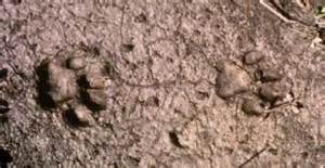
….1744:112215:77F:0000:CAMERA1: Florida Panther walks through Martin County, Florida 11/22/15…1745:112215:77F:0000:CAMERA1:3…..1745:112215:77F:0000:CAMERA1:3Panther tracks
So close to the St Lucie River/Indian River Lagoon… Do you see his tracks?
I have been holding back on writing this blog, but today seems like the “puuurfect” day to write! Trapped inside with all this rain has me daydreaming about Florida adventures.
Did you know that a panther was spotted just ten miles west of Palm City in November of 2015? Just two months ago? Maybe he is there today– hiding in the palmettos– trying to get out of this rain.
I learned about the panther’s visit to Martin County when I attended my University of Florida Natural Resources Leadership Institute in January. I didn’t write about as I was not sure I could share the photos. As I have learned the photo are public, I am now sharing. I learned the following from my source:
The person who shared today’s photos with the Florida Wildlife Commission advised that the photos were taken on a trail camera at Allapattah Flats in Martin County’s Wildlife Management Area on November 22, 2015. He/she advised the camera was in the Wildlife Management Area off of State Road 714, but did not give any more specific location.
Panther biologists confirmed that this is “FP232.” This panther was hit by a car in Ft Meade in Polk County northwest of Lake Okeechobee, in April of 2014. He is a male and was given veterinary care by the University of Florida for his broken leg, and rehabilitated in Yulee until his release in January of 2015. FP232 was released at Kissimmee River Prairie Preserve State Park, and has since roamed all over south central Florida. It was very exciting to learn of his appearance in Martin county.
I think this is so totally cool. Panthers were once common in Martin County, in all Florida, but now as Florida is full of highways, houses, and swimming pools they are very, very rare; I have written about panthers before, but never thought I’d get to share a photo of one right here. Very rarely are they photographed…
May the panther who visited us have the very best of luck! I will take this public opportunity to name him “Martin” as FP232 is not a name fit for such a magnificent creature.
My Frances Langford theme continues. Today I will share some photos of Frances’ St Lucie River estate treasures given to me by blog reader and salvage director, Bobbi Blodgett. Bobbi recently contacted me. Not only did we have a very interesting conversation regarding the recent destruction of the Langford property and the difficulties of getting developers to “reuse and recycle,” but Bobbi also shared some good news about what was “salvaged” from the Langford Estate in 2008 when it was first being “deconstructed,” as part a tax write off for the developers via Habitat For Humanity.
Her email reads:
“Hi Jacqui,
Langford additional pics during 2008 deconstruction project. Frances was very into Polynesian style and the “tapa cloth” pictured, we salvaged also, It was all handmade and imported. It was laid on the bars, walls etc.
The long bar was in the river house. I believe it was purchased by a couple who bought the house she owned on Hutchinson Island, which is awesome.”
ReUse Salvage Inc.
Bobbi Blodgett, Director
“Green & Clean”
De-construction Services
Removal of Products for Reuse http://www.reusesalvage.com/
….
Thank you to Bobbi for allowing me to share so many pictures. It is fun just to look through them. So many memories! Thank you for this historic documentation. May everyone enjoy!
….…….….….….….…..….….….….….….….….…..….…….….………….
….….…..…….….….….Frances Langford 1913-2005….The estate2016 scraped clean for Langford Landing (Photo JTL and EL)
Map of our area in the 1982 Coastal Management Zone document showing heights. in MC. (Mark Perry)
Yesterday’s conversation regarding Sewall’s Point’s Mount Pisgah, at 57 feet, in the area of Frances Langford’s former estate got people talking about many things. One of the less controversial, but interesting was “heights.” My brother Todd wrote:
“Jacqui, with respect to Mt. Pisgah being the highest point, I think you are correctly specifying “along” the rivers (e.g. adjacent to the water). There are higher points listed in my video below. But all the ones on the waterfront are less than 37ft. The highest waterfront in Hobe Sound is 50ft and we ran US-1 over it!”
Mr Don Quazzo in his comments noted the even higher heights than Mt Pisgah of the inland sand hills in the Skyline Drive area….interesting. Fascinating. Talk about history!
Today I will transcribe a piece of “Martin County’s 1982 Coastal Management Zone” shared with me years ago by Mr. Mark Perry. It talks about high places, ancient sand dunes, through out our county.
View Todd’s Time Capsule Flight video “The Hills of Sewall’s Point and Jensen Beach 1950 USGS Topo Map”: (https://youtu.be/fIwsz5grVg0)
More detail of height in MC. Figure 3
Here we go:
The 1982 Coastal Zone Management Study of Hutchinson Island, Martin County, Florida, 1982, wa written by Florida Oceanographic Society and the Martin County Development Department.
Part II is entitled “Natural Geologic History.” It reads: “Just before the most recent Ice Age, the Wisconsin, which lasted from 100,000 to 11,000 years before present, the sea level was approximately 25-35 feet above the present mean seal level…At that time the sea was covering most of Martin County except for the Orlando Ridge, which was a narrow peninsula or series of islands and shoals, and the Green Ridge which was an offshore bar with the crest at sea level…The sea beating against the much smaller Florida coast formed, by erosion and deposition, a broad terrace of Pamlico sands.
These sands were composed of mostly quartz, fossils and some carbon materials. The Atlantic Coastal Ridge was of pre-Pamlico origin was altered by an advancing Pamlico sea. This is evident by the south and north boundaries of the Jensen Beach and Jonathan Dickinson Sandhills which have spit-like structures projecting westward, as shown in Figure 3. (above)
The tall sandhills together with Sewall’s Point and Rocky Point form the backbone of the Atlantic Coastal Ridge. It is breached by the St Lucie River between Sewall’s Point and Rocky Point. During times of high sea level, like the Pamlico Period, the drainage basins of the St Lucie River and Loxahatchee River probably formed and ancient lagoon such as the Indian River Lagoon does today, with the older sandhills of Jensen Beach and Johnathan Dickinson acting as the barrier islands and dunes of that time. It was also during this time when Hutchinson and Jupiter Islands began forming as offshore bars….
—-Excerpt from MC 1982 Coastal Zone Management Study
Whether it is 100,000, 11,000, or 60 years ago, the more we know about the history and formation of Martin County the more likely we are to respect our natural resources.
Former Langford Estate, 1-20-16 Photo by Ed Lippisch.
Today I continue documentation of the former Frances Langford Estate, the 53 acres bordering Mount Pisgah and the Town of Sewall’s Point. Mount Pisgah, at 57 feet, is the highest point in the region along the St Lucie River and Indian River Lagoon.
I have written on this topic extensively already. Perhaps, too much. So I’ll keep it short and just say, once again…”There has to be a better way to develop property with such historical significance, and once, such tremendous natural beauty.”
Yes—- this type of development is within the law, but is it within our conscience? What was Martin County and the Commission thinking when they approved this transfer? How can we stop this from happening again? Can we?
Anyway—I did recently visit the site and the “Engineer of Record” assured me the high bluff will not be leveled to allow for more homes as is rumored.
“It is the lot’s majestic view of the water that we want…” he said. Six will face the river. You can see that lots are small compared to Sewall’s Point.
Personally, I think it would have looked even more majestic if some of Mrs Langford’s world-famous tropical vegetation and pond had been left and the lots were not so crammed in.
In conclusion, here are some photos for “the record.”
Thank you to my husband, Ed Lippisch for taking the aerials. All were taken yesterday, January 20th, 2016.
Oh, by the way, when I was leaving I noticed the documents stated that the cleared land had to be “seeded” within 30 days. We’re getting close. The lot was cleared at Christmas. I bet they put in sod. From tropical paradise to sodded conformity. What a loss.
Front of Langford Landing today 1-19-16. (Photo JTL)Langford home stands on barren hill 1-19-16. (Photo JTL)The subdivision Langford Landing. 6 houses will be located on bluff overlooking the St Lucie River. (Documents on site)A 60 boat marina will be put in. The submerged lands went with the property.…..…….….
Frances Langford’s tiki hut on her estate as possibly portrayed by Emile Gruppe. (unsigned)
Sometimes things are a mystery and reveal themselves slowly through many days…such is the story of black and white sketch of “The Hut” you see above.
I first saw the piece in an email dated January 14th, 2016, sent to me by my mother, historian Sandra Thurlow. Her email read: “I came across this in a box of treasures. It was an invitation to a joint birthday party for Talley Crary, Frances Langford Stuart, and Jane Merrell. I guess it was “The, with a capital, Hut.” Mom
Prior to receiving this email I had traveled on a yacht up the St Lucie River with my next door neighbor Mr Rohloff—this was two days after Christmas. This was when Ed and I saw up close the destruction of the former Langford Estate. Cleared to the bone.
Scared clean, Frances Langford estate today. (Photo Jacqui Thurlow-Lippisch)the Tiki Hut and pond, Frances feeding her swans. (Aurthur Ruhnke courtesy o Sandra Thurlow, 1961)….
When the captain of Mr Rohloff’s yacht heard me gasping as I saw Mrs Langford’s wrecked estate he told me he used to live on there, and was married there, and that he actually worked for Mrs Langford for some time. His name is Rick Copeland. Captain Copland continued to talk about Mrs Langford throughout the trip and told stories of what a remarkable person she was.
He told a story that as she was aging she gathered all the painting of Emile Gruppe who she and her husband collected and gave them to the artist’ son. “These were very expensive paintings……” She wanted to make certain they were given to the right place and appreciated….
Now fast forward to last weekend. I attended an Environmental Studies Luncheon and sat next to Matt Kelly, who oversees the real estate for Martin Health Systems and years ago was my swimming coach. He took his phone out showing me the same ‘The Hut” piece going back in an email to the son of Emile Grippe and with my sister who works for MHS.
It’s a small world and the heart of Frances Langford lives on!
By just doing a quick search on the internet I found an article about an art show in 2013 in Naples of these Langford/Evenrude paintings! The Gruppe family is very famous and there were three generations of paintings as you will read.
It would be fun if I could find more of the the paintings to share. Here’s one I found. Mrs Langford called her house along the St Lucie River, the “River House,”—maybe this is hers?
Easter party at our Thurlow family home in 1971, St Lucie Estates, Stuart Florida. Students and Mrs Jernigan were from JD Parker Elementary School.…..
In celebration of Martin Luther King Jr. Day, I am going to write a short blog and share some pictures from my baby book about growing up in Martin County. Mind you, I was born in 1964. In 1971 I attended first grade at Parker Annex–J.D. Parker in Stuart.
When I attended J.D. Parker Elementary School in Stuart I was six years old, so I never thought about being black or white. I think very young kids innately realize that blood runs red in everyone. We are all the same until we are told we are different.
Although I did not feel “different” when listening to stories of the grown-ups I could tell it used to be very different.
I remember my father being disheartened and sharing stories about how when he was growing up in Stuart, Florida, in the 1950s, there were white and black water fountains, and the black community had to sit in a designated area at the Lyric Theater….Schools were separated. I remember going to the doctor’s office on East Ocean Blvd. and there were two sets of doors..I would ask: “Mom why are there two sets of doors?” Well Jacqui, not too long ago, one set was for blacks, and the other one was for whites.”
I remember hearing that there were certain beaches along Hutchinson Island and the Indian River Lagoon were for blacks only…even the water was segregated?
All this seemed crazy.
It was not until I became an adult that I realized how near all of this history is. Just one generation away. Hard to believe isn’t it?
When I finally grew up, I taught 9th grade English and German at Pensacola High School and one of my favorite readings for my English students was Martin Luther’s Kings’ “I Have a Dream.”
Every MLK Day I read it aloud and remember…..It is a great inspiration….today or yesterday…
“I have a dream that my four little children will one day live in a nation where they will not be judged by the color of their skin, but by the content of their character…I have a dream today….”
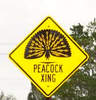
Frances Langford publicly photo.Standing before a giant photo of Frances Langford at Florida Oceanographic’s event 2013. (Photo Ed Lippisch)The former Langford Estate, cleared for development of Langford’s Landing, 2015. (Photo Jacqui Thurlow-Lippisch and Ed Lippisch)Local celebrity, Frances Langford, in her later years stands next to a pen containing peacocks on her property in Rio. The peacocks roamed freely on her land while she was alive. (Public photo)Sign in Rio.
As we all know, movie star and local philanthropists, Frances Langford, was and is very loved in Martin County. Nonetheless, recently her 53 acre river estate, in Rio, was mowed down for development to create ironically “Langford’s Landing.” Yes, it was legal, but what a shame. What a crime of local history. Part of that history included Frances’ flock of peacocks.
Invasive or not, Frances brought the exotic birds to her property in the 1940s and they had been happily living here ever since. They became part of the cultural landscape of the Rio area. Over the years the county even erected signs warning drivers about the birds.
After Frances’ death in 2005 there were tougher times for the peacocks, peahens, and peachicks but they managed to survive. They had become “wild” living off the land although some residents would joyfully feed them. Kind of like cardinals…. 🙂
Sometimes stopping traffic as they lollygagg across State Road 707, the birds cause smiles and sometimes cursing and horn blowing from drivers. Inconvenient? Maybe— but so cool! So local! So “Frances”…..a reminder of her philanthropic spirit and love for our area with every sighting!
Of course since the 53 acres has been clear-cut and scraped the peacocks have lost their home base habitat. Did anyone even think about this? I mentioned it at a county commission meeting years ago. Perhaps the county thought no one would notice when the birds fell on hard times or were possibly eradicated?
This was not the case. Not along the Indian River Lagoon…not in the land of River Warriors.
Yesterday there was a great win for the spirit of Frances Langford and the peacocks when resident Toni Rummo used social media to inform the public that a bank and real estate agency had “ordered the trapping of the peacocks at 1547 SW Sottlong Avenue.”
The house is in foreclosure and the cleaning people were apparently put off by all the birds. This led to the trapping or quote for such. According to Rummo some birds were trapped but after the outcry the others were left alone. Even the media, Sheriff’s department, and Martin County Commission got involved. It was crazy!
Than you to Toni Rummo and the others! Just to follow up, I spoke to Bill Dean head of Century 21 on Hutchinson Island whose company was incorrectly linked with the sale and he said it was a day like no other. The phone rang off the hook!
At the end of the conversation I said: “But isn’t it great? The love of Frances Langford and the people standing up for her spirit?”
We laughed. I recommended having a gin and tonic in her honor.
Thank you Toni for the peacock win! It was a win for the people of Rio. A win for the spirit of Frances Langford, and a win for the spirit of St Lucie River/ Indian River Lagoon!
One of Frances Langford’s peacocks in a royal poinciana tree on her estate.Rainbow over Langford Estate 2014. (Photo JTL)
Map showing Big Cypress Swamp next to the Everglades. Also note Lake Okeechobee.
The maps and information in today’s blog is taken from an article entitled “Big Cypress Swamp,” by Benjamin F. McPherson, that is included in the 1974, “Environments of South Florida Past and Present,” complied by Patrick J. Gleason. As I have mentioned previously this week, this text was lent to my by Dr Gary Goforth who gives insight into understanding our St Lucie River/Indian River Lagoon system and our Lake Okeechobee and canal issues.
….cover….The Everglades and Big Cypress Swamp.
This above map gives one an idea of how far east the Everglades used to go and how much development has crept in (see below)….how come agriculture and development didn’t totally take over Big Cypress? Well, perhaps they could not stop the water….
West of the red lines shows the edge of what was once the Everglades in South Florida. Development has crept and continues to creep over this edge. (Photo/map courtesy of Chappy Young,/GCY Surveyors, 2014.)
Big Cypress Swamp…we may not think of it too much over here on the east coast but we should study it as well. It is sister to the Everglades and people fought to save parts of it and were successful. It became one of our nation’s first national preserves in the same year Patrick Gleason’s text was published, 1974. I was ten years old and my family had just moved to a very undeveloped Sewall’s Point.
Today I will transcribe from the parts of the summary from McPherson’s work. I like reading the old texts. Sometimes they seem more clear and easier to understand. It helps us understand how things have changed looking an old book like we grew up with instead of today’s electronic media.
Excerpts from “Big Cypress Swamp,” by Benjamin F. McPherson
“The Big Cypress Swamp differs form the adjacent Everglades in topography, soil, water quality, and vegetation. Because the swamp has relatively more high land, inundation soil deposit are less extensive in the swamp than the Everglades. Soil in the swamp is usually a thin layer of marl sand or mixture of the two or is absent where limestone crops out where as soil in the Everglades is usually deeper organic peat. Vegetation in the swamp is closely associated with typography, water inundation, and soils, and is more diverse and forested than in the Everglades…
Big Cypress Swamp is a flat, swamp area of about 3120 square kilometers in SW Florida. It is seasonally inundated over as much as 90 % its surface area. Water moves slowly to the south by overland flow toward the estuaries. Fifty -six percent of the surface water that flows into Everglades National Park comes from the Big Cypress. A substantial amount of water also enters Conservation Area 3 from the Swamp. The western part of the Swamp is drained by canals and no longer floods extensively…
The quality of water in the big Cypress, particularly in the untrained parts is in generally of better quality that the water in the Everglades. Some contamination by metals pesticides and other potentially toxic chemicals does occur however….
Up close map 2 drainage of Big CypressFull summary from article
Today we continue looking at parts of a 1974 text entitled: “Environments of South Florida, Present and Past,” by Patrick J. Gleason, lent to me by Dr Gary Goforth.
Today’s map of study was created by Frederick A. Ober.
Fred Ober was a man who once ran a shoe shop, but one day, with a dream in mind, literally “threw off his shoes.” He decided to go on an adventure and make something more exciting of his life. In 1974 he visited and documented our Lake Okeechobee and surrounding Everglades.
Our text ironically, looks at Lake Okeechobee 100 years after his visit–published in 1974.
To look at the map and see such notes as “commencement of cypress belt with sandy shore” along the east side; “custard apples, and marshy lands, —-sand beach on the south side”; and “palmetto ridge and Kissimmee Prairie in the north,” really take one to another world.
—A world that basically does not exist anymore.
We scraped it clean. We rearranged it. We built it out. We drained it. We diked it. We planted seed. We erected houses. Maybe one day the young people will try to put some of it back. It must have been spectacular.
What will it look like in another 100 years? Will today’s Google map below appear as obsolete as Ober’s? What do you think? Is there a way to go back? Envision 2074.
….cover of text, 1974south rimKissimmee River area, northNE area of lakethe lake up closeToday’s Google map, 2016.
Today we look back in history….but you have to look….
These historic photographs are marked “Fairchild Aerial Surveys, Inc.”
According to Mr. John H. Canada, president, Ocean Naval Architects, the year was 1925. You may recognize one of the images as it was used in a former blog post discussing the piled up sand of the C-44 canal. From 1915 to 1925 the government was connecting the canal from Lake Okeechobee to the St Lucie River and Indian River Lagoon. A big mistake!
These photos below were originally sent to my mother, historian, Sandra Thurlow, by Mr John Whiticar. In their discussion, it is noted that one can see farming where Indian River Plantation is today (The Marriott); one cannot see an Intercostal Waterway–no spoil islands off Sewall’s Point; there was no development on Rocky Point; and most interesting for me, looking at the photo this time: today’s Martin County Golf Course, part of yesteryear’s “Sunrise Inn,” sits right there “in the middle of no where” in 1925. Those were the days!
Frances Langford and Ralph Evenrude photographed before their trademark Tiki Hut and pond, Jensen Beach Estate, 1961. (Photo Arthur Ruhnke with permission of historian Sandra Henderson Thurlow)Frances Langford as young movie star. April 4, 1913 – July 11, 2005
“I am sure the new development will be re-landscaped very beautifully, but it is hard to see the once serene property so desecrated.” –Local historian, Sandra Thurlow, 2016
“Frances Langford,” the name is as beautiful as the woman. She is a legend here in Martin County and much of the world. No one has been more generous, loving, and appreciative towards our community. A true philanthropist, her name graces buildings, parks, and centers from the Indian River Lagoon to Indiantown.
As a singer and movie star, she is best known for “entertaining the troops” during World War II aside Bob Hope. Through her family, young Frances was exposed to Jensen Beach, and later, after the war, came back to create her dream: “Frances Langford’s Polynesian Outrigger Resort.” It sat along the beautiful St Lucie River and Indian River Lagoon just north of Sewall’s Point.
Over time, inspired by her travels, Frances and her husbands created a tropical paradise known far and wide. Cottages, a restaurant, a marina, palm trees, rare foliage, freshwater ponds, peacocks, and even swans graced the property. Famous movie stars often visited. She gave Martin County a reputation and she put it on the map. She made Martin County’s Jensen Beach her permanent home.
Frances chose to build her personal residence near Mount Pisgah, the highest point of the peninsula. Lore has it that pirates and Indians once lived here too, standing on the high bluff looking for passing ships in the ocean. The property is steeped in beauty, history, and mystery. Sadly, in the end, the remaining 53 acre parcel was treated like any other piece of real estate.
After a long wait since the 2008 Great Recession, the property is finally being developed ironically as “Langford Landing.” The manner in which this is being done has taken most us by surprise.
Is it really necessary to remove every beloved palm tree, stately strangler fig, and blade of grass? Surely Frances thought some of her legacy might stand. It has not. The majority of the property has been scraped clean for new development. My sister said it best: “Jacqui, from the water, it looks like the property has been Napalmed.”
There has to be—-a better way.
The Tiki Hut, bridge and pond, Frances feeding her swans. Many fundraisers were held here and many movie starts attended “in the day.” (Arthur Ruhnke courtesy o Sandra Thurlow, 1961)Langford Estate 1961. (Arthur Ruhnke/ST)Langford Estate 1961. (Arthur Ruhnke/ST)View of estate from river by kayaker. This photo was sent to me by a Facebook friend.
Tiki hut in ruins 2016. (Rebecca Fatzinger)Around the pond, palm trees lay in a heap. 2015. (Photo by Rebecca Fatzinger)Today in 2015/16 photo of Langford property by (Rebecca Fatzinger)The grounds 2015/16 (Rebecca Fatzinger)Estate sold for development. (Courtesy Todd Thurlow/Google Earth)From the air–history scraped clean, 1-1-16, Frances Langford’s estate after all foliage has been removed. (Photo Jacqui Thurlow-Lippisch and Ed Lippisch )Langford Estate seen from the St Lucie River, 12-3-16. (Photo by Todd Thurlow)Photo of one of Frances Langford’s peacocks on her estate, 1980s. (A gift to me from her housekeeper 2006.)Young Frances. Public photo.Frances in her later years.
There are only a handful of people who are qualified to help us navigate the turbulent and murky waters of Lake Okeechobee and its effects on our beloved St Lucie River/Indian River Lagoon….
One of these rare individuals is Dr Gary Goforth. “Gary” has more than 30 years of experience in water resources engineering, encompassing strategic planning, design, permitting, construction, operation and program management.
For the last 25 years, his focus has been on large-scale environmental restoration programs in the Kissimmee-Okeechobee-Everglades ecosystem. He was the Chief Consulting Engineer during the design, construction and operation of the $700 million Everglades Construction Project, containing over 41,000 acres of constructed wetlands.
With all this experience Gary spends a tremendous amount of time at River Coalition and SFWMD meetings, and with every day people, advocating to local, state, and national officials telling the story in a manner that the average person can understand but with the power and expertise of a scientist.
Dr Goforth teaches us that we CAN HOLD THE ACOE, AND ESPECIALLY THE SOUTH FLORIDA WATER MANAGEMENT DISTRICT ACCOUNTABLE.
We can ask such questions as “are you sending the maximum practicable amount of water south?” “Is it 28% more than in 1994 as required by the Everglades Forever Act?” ” Is an average per year of 250,000 acre feet going south from the lake to the Everglades as required by the Everglades Forever Act?” “Are the Storm Water Treatment Areas being used to full capacity?” “Is the truth of the destruction of the estuaries being reported?” “Should 2008 LORS, Lake Okeechobee Regulation Schedule, been revised?” “Should the Everglades Settlement’s Q-Bell (limit of Phosphorus) be reviewed-is it realistic?” “Is a large reservoir being created in the Everglades Agricultural Area as is called for in the Central Everglades Restoration Plan?” “Who are the Lake and the STAs really serving?”
In order to hold the agencies accountable we must be educated! We must ask questions. We must look at the figures for water flowing south of the lake every year and compare.
Dr Goforth provides regular public updates on these issues, directly and indirectly holding the fire to the agencies. Today I am publishing in full his DRAFT–WET SEASON 2015 LAKE DISCHARGE report.
Please read it, study it, familiarize yourself with it. Dr Goforth has a website if you have any questions. Thank you Dr Goforth for the gift of shared knowledge. It is the greatest gift of all.
Draft – Wet Season 2015 Lake Discharges by Dr Gary Goforth:
Goforth – December 18, 2015
Flows into and out of Lake Okeechobee were examined for the period May 1, 2015 – October 31, 2015, corresponding to the first half of the annual water year (May 2015 to April 2016), and roughly corresponding to the south Florida wet season. The flows and associated Lake water levels were compared to same period from last year. In light of the influence of the current strong El Nino, Lake water levels were compared to the levels that occurred during May- November 1997 which preceded over 1 million acre feet (347 billion gallons) of destructive Lake releases to the St. Lucie Estuary between December 1997 and May 1998.
Flows into Lake Okeechobee – excluding rainfall. For the period May 1 to October 31, 2015, surface inflows to Lake Okeechobee amounted to 1.43 million acre feet (466 billion gallons) (Table 1). This is 20 percent less than for the same period in 2014 (Table 2 and Figure 1).
Flows out of Lake Okeechobee – excluding evapotranspiration. For the period May 1 to October 31, 2015, surface outflows from Lake Okeechobee amounted to 780,000 acre feet (254 billion gallons) (Table 3). This is 37 percent more than for the same period in 2014 (Table 4 and Figure 2). Approximately 30 percent more Lake water was sent to the EAA and L-8 Canals during 2015 than 2014, likely in response to higher water supply demands (due to lower rainfall than in 2014).
Lake Okeechobee water levels. The level of Lake Okeechobee varied from 13.81 ft on May 1 to 14.55 ft on October 31, 2015, reaching a low level of 11.96 ft on July 16 (Figure 3). For 2014, the level of Lake Okeechobee varied from 13.07 ft on May 1 to 15.85 ft on October 31, reaching a low level of 12.32 ft on June 11. Lake water levels rose only 0.74 feet during the 2015 wet season compared with a rise of 2.78 ft during the same period in 2014. The Lake level on October 31, 2015 was approximately 1.3 ft lower than it was a year earlier, and approximately 0.5 ft lower than October 31, 1997 (Figure 4). In addition, the Lake level on November 30, 2015 was approximately 1 ft lower than it was on November 30, 1997, which preceded over 1 million acre feet (347 billion gallons) of destructive Lake releases to the St. Lucie Estuary between December 1997 and May 1998. Two important differences between 1997 and today that could influence Lake discharges to the estuary include rainfall over the Lake Okeechobee watershed and the regulation schedules governing Lake operations. According to the South Florida Water Management District (District), November 2015 was the wettest November since 1998, indicating inflows to the Lake over the next month may be substantially larger than average. Additionally, the Lake is currently operated under the LORS2008 schedule which was anticipated to result in increased frequency and magnitude of Lake releases to the estuaries compared to the regulation schedule in place during 1997-1998.
Lake flows to the STAs. Beginning in August 2015, the District began operating the EAA A-1 Flow Equalization Basin (FEB), which is approximately 15,000 acres in size and can store water up to 4 feet deep. The FEB can receive Lake releases and EAA runoff, and distribute flows either to STA-2, STA-3/4 or to the EAA for irrigation. At this time incomplete flow records are available to the public through the District’s DBHYDRO database to fully account for the various flow paths, and until additional data are available, the estimates of Lake releases and runoff to STA-2 and STA-3/4 will be subject to revision. Using these preliminary estimates, approximately 13 percent less Lake water has been sent to the STAs in 2015 compared with 2014 (Figures 5 and 6 and Table 5). During the same period, approximately 32 percent less basin runoff was sent to the STAs, reflecting less wet season rainfall in 2015.
Flows to the estuaries. Lower rainfall in 2015 resulted in less basin runoff to the estuaries for the period May to October than occurred in 2014 (Table 6). However, due to the Lake releases that occurred during January through May 2015, Lake discharges to the estuaries in 2015 far exceeded Lake releases during 2014.
SUMMARY. Lower rainfall during the May to October 2015 period resulted in about 20 percent less inflows to Lake Okeechobee than in 2014. However, outflows from the Lake increased compared to 2014, likely in response to higher water supply demands (due to lower rainfall than in 2014). Lake water levels rose only 0.74 feet during the 2015 wet season compared with a rise of 2.78 ft during the same period in 2014. The Lake level at the end of October 2015 was about 1.3 ft lower than in 2014. In addition, the Lake level on November 30, 2015 was approximately 1 ft lower than it was on the same date on November 30, 1997, which preceded over 1 million acre feet (347 billion gallons) of destructive Lake releases to the St. Lucie Estuary between December 1997 and May 1998. However, differences in rainfall and Lake regulation schedules prevent a forecast of potential 2016 Lake discharges compared to the 1997-1998 discharges to the estuaries based on Lake levels at the end of November.
Dredge and fill, public photo, 2015.A multi-image of the area in the 1887 NOAA map, the 1925 shot (partially), 1940, a 1958 NOAA map, 1970 and today by Todd Thurlow.
Today’s blog is a full expansion of the 1925 aerial photo I wrote about last Friday.
My brother Todd took this photo creating a time line flight of 1925 and 1940 views of the Sailfish Flats, the Indian and St. Lucie Rivers, and the St. Lucie Canal (C-44).
Todd’s video is a history lesson in “dredge and fill” which was very common throughout all south Florida and the United States until national laws in the 1970s required more scrutiny and often no longer allow such due to heavy impacts and damages on waterways and the natural environment.
Our Martin and St Lucie County canals dug by the ACOE and water management entities C-44, C-23, C-24, C-25 are dredge and fill. Sailfish Point, Sewall’s Point, and Indian River Plantation, just to name a few, have large portions that are dredge and fill. The dike around Lake Okeechobee and the work abound the FPL plant in Indiantown by Barley Barber Swamp are dredge and fill. At the time, it was “how it was done.” People did not foresee the ramifications to the environment or to people living in these areas in the future.
The land was our Play Doh…
1925 aerial by Bob Higgins shared by Sandra H. Thurlow. SLR/IRL
I know you will learn a lot and enjoy watching Todd’s video. The link is above.
—My questions to Todd after I saw the video included:
Jacqui: “So Todd, what are the white lines on the edge of Stuart, Rocky Point etc…more piled white sand? Looks like Jupiter Island was smaller at one point…across from Sailfish…
So how in the world did they dig out the Sailfish Point Marina and what about the straight marina of Sailfish Point that was already there from the days of Mr Rand? Also what about the FPL Pond in Indiantown? Where do you think they put that fill? Holy cow! That’s a lot of fill!
(I have adapted Todd’s words after checking concepts with him so I could present info in a simple manner.)
Todd: “The lines on the edge of Rocky Point were probably a beachy shoreline. With it being more open water at the time and more exposed to the inlet; I’m sure there was more of a beach there. That shoreline matches perfectly the shoreline shown on the early NOAA maps – even before the inlet was there.
With respect to Jupiter Island, you are probably referring to all the spoil that was piled up at the entrance to the Great Pocket – some of that was put there when I was in middle school. The main part of Jupiter Island is more to the east and is now gone – and earlier connected to Hutchinson Island. The old Gilbert’s Bar Inlet was south of that point.
The marina on Sailfish Point was dredge fill. We have some aerials of it in the making. As was the case in areas of Sewall’s Point, the sand dug to build small marinas or subdivisions was piled on the land (Archipelago, Isle Addition) to make the land higher or to create completely new lands.
As far as the giant FPL pond, they probably just dug with a dragline and used the fill to make the dike around the outside of the pond and also to build up the land around FPL.”
Hmmm?
So we live in an environment altered by our forefathers, and now we are experiencing unintended consequences to the health of our St Lucie River/Indian River Lagoon. We must assist the next generation in understanding the past so that we and they can create a better water future. And that we can!
May 1925 aerial for the Sailfish Club by Bob Higgins shared by historian Sandra Henderson Thurlow.
This amazing 1925 aerial photograph of the confluence of the St Lucie River and Indian River Lagoon tells a story….I found this photo looking back through some old emails between me, my mother, and my brother dated 2010. At the time, I did not catch all of the nuances in the photograph….
For instance, look at the beautiful, healthy seagrasses hugging the elbow of the shoreline of Hutchinson Island; what about the dock in the midst of the seagrasses that is no longer there; the gentle, crashing waves over a thriving reef at “Bathtub Beach;” the entire area so pristine with extensive natural vegetation. Look at the wispy sandbars forming in the river… Nearby the St Lucie Inlet had been permanently opened, (1892), but also much “improved,” as 1925 was just before the real estate crash, great depression, and two hurricanes that altered Florida’s history forever.
In 1925, community leaders were actually planning a port, Port Sewall, one to complete with Miami and Jacksonville right in this area! In fact they dug a turning basin for ships just off the southern tip of Sewall’s Point and created Sandsprit Park with the fill. Can you imagine?
Back to the photo…
Notice there were no spoil islands off of Sewall’s Point–no Archipelago or Island Addition…Notice the sparse development of Stuart and the lack of an airport. Notice the basically undeveloped peninsula of Sewall’s Point, Rocky Point, and the even less developed— later named— “Sailfish Point.”….The Manatee Pocket just east of and beyond Sewall’s Point shows some signs of the coming future but not many….Do you see anything else?
For me the most interesting thing of all was caught by my brother Todd’s keen eye.
“What is that huge white stripe on the horizon??” He said. “It’s looks like a giant 20-mile-long spaceship runway. Well, it’s the spoil from the freshly-dug Okeechobee waterway. See it in the attached comparison from Google Earth.”
Looking upward and beyond in the 1925 photograph to the right of the clouds, Todd noticed the piled up sands of the C-44 canal—a long curving snake connecting Lake Okeechobee to the South Fork of the St Lucie River. Can you see them?
Of course we all know that this canal along with others and extensive development, over time, destroyed the healthy seagrasses, great fishing, negatively altering the beautiful paradise of the St Lucie River/Indian River Lagoon..
It’s fun to look back, but its even more fun to think about how we have the ability to improve things in the future.
….Google image 2010 showing C-44 canal to compare to 1925 aerial. (Todd Thurlow)
Sewall’s Point Post Office ca. 1890s. Photo courtesy of Historic Society of Martin County and Sandra Henderson Thurlow.
Certain photographs become imprinted in our minds, affecting us on an emotional level–conjuring up images and memories again and again….
One such photo for me is this late 1800s image of Captain Henry Sewall’s Post Office and home. The picture graces the cover of my mother’s book “Sewall’s Point, A History of a Peninsular Community on Florida’s Treasure Coast.” This photograph was often laid out on our family dining room table and we kids listened to mom tell stories of the house and the people from that era of history.
The first time I ever saw the photo it was like I was walking along the long, crooked dock myself to say “hello” or go pick up the mail. I could imagine a gentle breeze blowing, the sun shining, the birds flying over, the fish jumping, and yes, maybe a mosquito or two….
In my imagination, I also thought about how happy I would be to say “hi” to the Sewalls and to maybe get some mail…My mother in her years of writing the books repeatedly pointed out how “lonely” it was for the pioneers, and that the post office played a social role in the community as well as one of function.
With no roads, the St Lucie River/Indian River Lagoon—were the roads—the only means of transportation to greet a neighbor, get supplies, or pick up the mail. The river brought people tougher, just like it does today.
Yesterday, when I drove to today’s Stuart Post Office from Sewall’s Point to drop off Ed and my Christmas cards, I thought about how much things have changed.
But I have to say, that even though I did not recognize anyone at the post office, the holiday mood and bustle of mail led to many smiles just as it must have in the days of Captain Henry Sewall. The post office, even with all of the world’s changes, still holds the heart of “greetings and hellos,” especially during the holidays.
SEWALL POST OFFICE/HOUSE TIMELINE
1889: Capt. Henry Sewall builds a house on Sewall’s Point
1891: Sewall’s Point post office established in the house
1913: The house is moved by barge to Port Sewall
2006: The house is moved by barge to Indian RiverSide Park with unanimous support from the Martin County Commission and advocacy of historian Sandra Thurlow, Stuart Heritage, the Historical Society of Martin County and others. A large donation is made to support the move by Mr. Fred Ayers.
2012: Restoration of the house is completed/the house is listed as one of 11 properties on the Martin County Local Historic Register of Historic Places.
Merry Christmas and Happy Holidays!
Jacqui
Jacqui Thurlow-Lippisch
Sewall House and Post Office tip of South Sewall’s Point, ca 1890s. HSMC
All of Sandra Thurlow’s books can be purchased at the Stuart Heritage Museum (http://www.stuartheritagemuseum.com) on Flagler Avenue, the Elliott Museum, or ordered on Amazon.
Sofia slide on fish lesions in SLR 1999.Slide from Dr Gary Goforth’s December 2015 update on SLR/IRL Lake Okeechobee.
Today I would like to briefly remember 1997 and 1998 and recall why this year is so important to our St Lucie River/Indian River Lagoon history. I would also like to note for some who may not know why these years are being brought back into the ACOE/SFWMD discussion this year.
Today’s slide is complements of a recent document shared by our friend, Dr Gary Goforth. (http://garygoforth.net) “Draft – Wet Season 2015 Lake Discharges – December 9, 2015.” This slide shows that Lake Okeechobee today is lower than it was in 1997.
Why is Dr Goforth comparing 1997? He is comparing 1997 because in 1997-98 there was a strong El Nino (rainy winter), just as we are experiencing right now in 2015/2016.
Certainly we have all noticed how much it is raining this winter so far!
The difference as far a Lake O management in 1997-98 was that there was no”LORS” schedule then….The 2008 LORS or “Lake Okeechobee Release Schedule” did not go into place until 2008 so prior to that year the lake was allowed to be over a foot higher. Since 2008, the lake is required to be lower because of work and safety issues on the Herbert Hoover Dike.
It is important that as we move forward to also look back. We must remember what happened in 1997-98, a similar El Nino to what is happening right now…. 1997-98 were not good years for the river…So much water was released into the St Lucie River/Indian River Lagoon in 1997-1998 that there were more reported fish lessons than ever before– due to too much and too long of exposure to fresh water. This is also why, in 1998,the Rivers Coalition was born. (http://riverscoalition.org)
Section of Dr Goforth’s report on Lake O levels December 9, 2015.
Ed and I at a bus stop for tourists east of Havana.A new bridge at the tourist stop. Wild royal palms were scattered across the hilly horizon. The ocean to the east…
It has been awhile since I have blogged; a lot has happened. I think I’ll start with Cuba.
One of the stories my father relays to me with great relish is his 1954 Stuart High School senior trip to Havana, Cuba. Can you imagine that? A senior trip to Cuba? My dad grew up on Riverside Drive in Stuart, Florida, in the 1950s, on the St Lucie River/Indian River Lagoon.
With a broad smile and sparkling eyes, he tells of magnificent buildings, music, art, restaurants, and night clubs around Port of Havana, and having “lots of fun.” “In fact one of the students had so much fun, he was sent back to Stuart!” My dad laughs out loud, with thoughts of the “good old days.”
My father’s Stuart High School class traveled with chaperones before Fidel Castro’s 1958 rise to power over Batista and later the embargo and tumultuous history that the world has watched unfold for over a half century.
My husband, Ed and I, traveled for a very different reason during a very different time. Two weeks ago we left on a journey with the Episcopal Diocese of South East Florida and we were classified by the government as”pilgrims.”
Stuart High School senior trip 1954. My father, Tom Thurlow, is standing in the back row one from far right.
Our journey was led by Bishop Leo Frade of Miami and his wife.
The trip took about fifty people, including other priests, to Havana, Cardenas, Lemonar, Bolondron, Metanzas and back again to Havana. We visited churches that were rebuilding since the communist government allowed them in the 1990s to once again worship. They have few resources but great spirit.
Group in Old Havana square.….
It was a great education for me. If I had to describe the experience in one sentence I would say: “Government is corrupt, not its people.”
To see the smiles and hear the appreciation of those we met along the way, to think about all they have endured, to realize more than ever before how much I take for granted.
I have visited poor countries before. I lived and taught in Berlin, Germany in 1990 just after the Berlin Wall came down and East Germany was emerging from the brace of communism…I think what was so different for me about Cuba, is that it is so close to home and I know some people who lost everything. Also, the flight took less than an hour. Cuba’s climate is much like Florida; it is geologically considered part of North America.
Although most of the buildings were falling apart, it is a beautiful, beautiful country…So here are some photos. May the next generation of Thurlows see something better, but may the smiles and the warm spirits of the Cuban people stay the same.
With our guide.…Limonar’s church.…..There was no roof.….The priests.…..….….…School kids in uniform. Cuba is highly literate.………Old American cars still running……….….…….……Sugarcane has a long history in Cuba and is very tied to South Florida in the U.S.…….….Havana.…Fixing up old buildings…….
_______________________________________
Last night my Dad and I took out the souvenirs from his 1954 senior trip to Cuba.Photograph my dad saved of the school bus taken from Stuart to Miami in 1954.
Confluence of St Lucie River/Indian River Lagoon at St Lucie Inlet. This aerial shows mosquito ditches through mangroves and other vegetation on today’s Sailfish Point. Due to state and local protections, the mangroves could not be removed today as they were in Martin County in the late 70s and early 80s. Aerial dated 1952 courtesy of Thurlow Archives.
“A rose is a rose is a rose…”
The “Coral Strand” was a rose; “Seminole Shores” was a rose; “Sailfish Point is a rose…” and whatever Native American name the Indian’s had for this sacred area was also a rose….
In her poem’s famous first line: “a rose is a rose is a rose,” poet Gertrude Stein’s words are often interpreted as meaning “things are what they are”…”using a name of a thing already invokes the imagery and emotions associated with it..”
For me all these names are “a rose” evoking different images and times of Indian River Region history. The Coral Strand being the name given to the land by the McCoy brothers–famous rum runners and wheeler-dealer business men. Seminole Shores the name given by James Rand a wealthy eccentric of our area whose riches founded the Florida Oceanographic Society; and Sailfish Point the name given to the area after its development by Mobil Oil Corporation in the 1980s.
Will there be another name in the future? And if so what will it be? Well–a rose is a rose is a rose, always and forever…..no matter the name.
Picnicking at the Coral Strand 1927, “for sale/lease” sign in the background. Photo courtesy of Stuart the History of Martin County.According to the History of Martin County the Coral Strand was for sale for $25,000 in the 1920s.Wider view showing the SLR/IRL in all its former fishing riches, impacts from regional development agricultural canals, and area development with removal of vegetation have lessened water quality.
El Nino means possible heavy rains for our SLR/IRL region during the coming winter.
I woke up this morning to the percussion of hard, fast rains hitting our tin roof… In my foggy state of slumber, I bumped Ed’s shoulder, “How are you going to take out the dogs?”
Rolling over, I started thinking about what I’d heard on Tuesday’s Army Corp of Engineer Periodic Scientist Call: “…How are we going to prepare if NOAA’s El Nino rain predictions are right? What if there is up to seven feet of water that fills the lake?….”
Seven feet? That would mean releases from Lake Okeechobee this Florida winter.
Remember 2008 and Tropical Storm Fay? For reference, that storm raised Lake Okeechobee by more than three feet in no more than few weeks. The lake fills up six times faster than it can be “drained”….and as we all know, we are the drainage pipe.
It’s an odd thing how the flow of water going south to the Everglades is blocked by the EAA (Everglades Agricultural Area) so now the over-flow is directed to the St Lucie River and Caloosahatchee. But it’s a reality. A reality that one day must be changed.
We must restore the flow of water to the Everglades and halt releases to the SLR/IRL. This requires land purchases and reservoirs.
Remember–too much fresh water, as during releases from Lake Okeechobee, is a pollutant to our St Lucie River/Indian River Lagoon— altering salinity, destroying spawning/fisheries, wiping out seagrasses and food throughout the food chain, lowering property values and the right of residents and their children to have “peaceful enjoyment” of their property…Yes, I can clearly state that toxic algae blooms and fish lesions do not precipitate peace for the Town of Sewall’s Point, nor for Martin and St Lucie Counties.
So how do we prepare? We must educate ourselves ahead of time; we shouldn’t over fertilize; we should get our septic tanks checked; and we should contact our legislators now saying we want to see a plan. We want to know ahead of time what may happen if indeed seven feet of water fills the lake between December and this coming May. How will we adapt to knowns and unknowns? We can’t just wait. Not when it’s this clear…we must be proactive on every level.
Legislative delegation Senate President Negron, Representative Harrell and Magar, what are we doing now to deal with all this water and what are we going to do in the future? The C-44 Reservoir/STA is great but it does not address Lake Okeechobee…. Why are we wasting the valuable water? What about Amendment 1 and the purchase of lands?
The barrier island of Hutchinson Island, 1957. Atlantic Ocean on left. Indian River Lagoon on right. Photo courtesy of Thurlow Archives.
The sands of time….shifting, reforming, just like my childhood memories. 1977–Seventh grade—I remember riding my bike with my best friend, Vicki, out to Hutchinson Island. No traffic. Along the way we would take our hands off the handle bars holding them over our heads, laughing and shouting “look mom!”
A veritable paradise and giant playground we left our bikes at Stuart Beach not locking them and jumped into the ocean.
This photo was taken in 1957, twenty years before Vicki and my bike ride, but it was still relatively undeveloped at that time. If my memory serves me correctly Indian River Plantation’s first condo, The Pelican, went up in 1976 and later in the 1980s the establishment filled out to its final glory. Later sold to the Marriott these lands, though altered, remain a beautiful part of Martin County with public beaches for all to enjoy.
I got ahold of this photo from my mother asking her what kind of vegetation pre-development was on the island. This was her reply:
“This aerial was taken on October 16, 1957. The causeway was under construction as were improvements to Stuart Beach. It is hard to tell what kind of trees are there. They were probably a variety of things, oak, salt bush, cabbage palms, palmetto and Australian pine. The later were growing at the House of Refuge at this time so they were no doubt popping up everywhere. It was “disturbed land” since patches of it had been cleared for farming. Mangrove would be growing along the water but I doubt they had reached inland yet. You can see the new piles of sand indicating mosquito ditches had recently been dug. Notice the little Beach Road.” Historian, Sandra Henderson Thurlow
Thinking a bit more about this area I asked my brother, Todd Thurlow, if this area formed “the fan” because it was once an inlet, such as the Gap, he talks about so much. He sent me this:
“The steady forces of long shore drift have operated over the eons to produce not just the current BI and previous BIs such as the ACR on the mainland, but even the peninsula of Florida itself (Schmidt 1997). The strong linearity of the east central and southeast Florida coastline, its low fractal dimensionality (Rial n.d.), indicates the steadiness and consistent directionality of these forces. Chaotic events like storms, on the other hand, produce drastic BI and lagoonal modifications via overwash and tidal inlet cuts, and leave chaotic, or irregular (“squiggly”) backbarrier shorelines, the former producing overwash fans, and the latter producing flood tidal deltas (Figure 3-6).
Figure 4-19. Cartographic signatures of geomorphic stability and instability. Map to left is most north, right map is most south”
Alan Brech, NEITHER OCEAN NOR CONTINENT: CORRELATING THE ARCHAEOLOGY AND GEOMORPHOLOGY OF THE BARRIER ISLANDS OF EAST CENTRAL FLORIDA, 2004.
——————————
Translation: Breaks occurring during storms create overwash fans. (e.g. IRP and Sailfish Point). Tidal inlets produce flood tidal deltas, somewhat like the old Gilberts Bar. BI = Barrier Island; ACR = Atlantic Coastal Ridge. —-Todd Thurlow, “Time Capsule Flights:”(https://www.youtube.com/playlist?list=PLDaNwdmfhj15bmGNQaGhog9QpkQPAXl06)
The shifting sands of time… So many wonderful memories, and so many more to make as times and sands continue to change.
IRP Marriott today, Google Maps 2015.Wide view, red dot is IRP Marriott 2015. Sewall’s Point east.
The Pettyway Grocery’s location has been in business serving the Gomez community since ca 1920s. Photo Duren Roofing, Facebook.Map today of inland area of the Gomez Grant. Town of Gomez in bottom right.
It was Sunday afternoon and I was driving south on Dixie Highway. Henry Flagler’s train tracks and the Indian River Lagoon were just east of my line of sight. From a distance, I saw the grocery’s signature blue trim. I’d driven by hundreds of times but never gone inside….in an instant, I knew this was the day.
I pulled over my car and walked inside. The bell clanged against the door and I could see an older pretty African-American woman doing paper work; I bent down and stared through the shelves…”
“This must be the matriarch of Gomez,” I thought. She looked up at me with sharp, clear eyes, like an eagle. When she saw me standing there, her expression softened and she smiled. “May I help you?”
“I am looking for Mrs Annie Pettway,” I said.
“That’s me,” she replied…
I told her who I was, why I’d come, and that I’d just recently met her niece , Mrs Ollie Harvey. Mrs Pettway invited me to sit in the chair by the side of her desk. We spoke and she told me of her long and change filled life in the Indian River Lagoon Region of Gomez in Hobe Sound.
She was born in 1941. She had been through segregation and desegregation. She had seen it all. Her mother Mattie Mae, and father, Bill Pettway moved to the area in 1909 from Alabama. They worked hard, purchased land, apartments, a trucking business, and the area’s first grocery store. Her father was the first black man to own his own business. Today, there is a park down the street named in the family’s honor…
“Were you born here I asked?” She smiled and hit her knee. “Yes mam; I was born right down the street!” She pointed southwest.
People came and went in the store, both black and white; everyone seemed in good spirits and the conversation was relaxed and familiar. I felt like I was in the Bahamas. I liked the feel. The bell would clang and Mrs Annie would get up and ring her customers out while I waited. While she worked, I watched her and I thought about all the history and all the people who had walked through those doors. I thought about how much things have changed along our Indian River Lagoon.
I also thought about what my mother and brother have taught me about this unique area of Martin County…
This land was part of the famous Spanish Gomez Land Grant preceding Florida’s stateship in 1845. Due to title/legal issues that eventually played out in the United States Supreme Court, the land was not surveyed in the 1850s like the rest of Florida. The Gomez Grant situation was eventually worked out, and then acquired by the Indian River and Pineapple Growers Association in 1893; later, the Indian River Association in 1904. It was really the Indian River Association that began “developing.”
When looking at a map you’ll notice that unlike most of the rest of Martin County, other than its sister “Hanson Grant,” the roads of Bridge and Pettway stand out. None of the Gomez Grant area roads run directly east/west or north/south. Instead, the east/west roads run at a roughly 66 degree northeast angle, which is perpendicular to the shoreline, following the old Spanish land grant. The north/south roads run approx 24 degrees west of north-south or perpendicular to the east-west roads…This makes this area unique and gives it a historical “signature.”
Gomez Grant from the book of Nathaniel Reed,” A Different Vision.”
I stopped day-dreaming…
Mrs Annie sat back down.
“Mrs Pettway, why don’t they call it “Gomez” anymore? Wasn’t this area called Gomez?
“That was the old name, and it is still Gomez, but today we call it all Hobe Sound. It’s all one name now; things have changed.” There was a twinkle in her eye, and I stopped asking questions. I suddenly knew that no amount time could really tell the amazing American story of Mrs Annie and the family of Pettway.
Annie Pettway in the 1960s. Photo from History of Hobe Sound, by Paula Mac Arthur Cooper.
The house built in the “outback” by Maggy’s mother in the early days of a growing Miami.……..The driveway leading to the house. (JTL)The porch.The grounds has many trees planted by Mrs Reno years ago that are now gigantic.Oolite rock on the grounds.The house only lost one shingle during Hurricane Andrew in 1992. This hangs on the wall as a testament to Mrs Reno and her husband.Cover of book. Mrs Jane Woods Reno.In 1994, when I was a much younger woman, my mother handed me a book entitled: “To Hell With Politics,” a compilation of the writings of Jane Wood Reno.
My mother noted that the author was an incredible woman. She had built her house with her own two hands; was a savant; she had had a career as a reporter for the Miami Herald; she once hiked many miles northward, for days and nights, along the Atlantic’s shoreline meeting, speaking, and writing about the people she met along the way; she had befriended the Miccosukee Indians and they considered her an “Indian Princess;” she raised peacocks on her very large parcel way out west of Downtown Miami; she was a dedicated mother and wife…..she was Martin County Commissioner Maggy Hurchalla’s mother.
To say the least, I found Mrs Reno’s story interesting and never forgot the book. Fast forward twenty years; I was invited to visit the house, and I did.
Driving down on October 24, 2015, I thought it would be a straight shot down the Turnpike from Stuart. But somehow I “took a wrong turn” and ended up in the craziness of Downtown Miami driving in carpool lanes as a single driver, cameras taking my picture, and barriers forcing me to stay in “my lane.” As I pulled off I-95 stressed out and sweating Siri’s voice rung in the tense air. Then I saw it, the mailbox.
Turning right down a long unpaved driveway I exited the bustle, excessive traffic, shopping malls, and crowded housing developments, and went back in time. Driving in I noticed wild coffee plants and gumbo limbo trees just like some areas of our St Lucie River/Indian River Lagoon. “Weird.” I thought. “Is there a creek around here somewhere? I wonder what Kendall looked like before they drained it, filled it, mowed it down, and planted hedges? A pine forest? An oak/palm hammock? Beautiful…”
I parked my car and looked around. Time stood still. A tropical breeze floated through the trees and the sun shined. Birds were chirping. Legend Maggy Hurchalla greeted me and I toured the grounds of her family home. She was there caring for her older sister, former U.S. Attorney General, Janet Reno. It was a day I will always treasure. A day a book I read as a younger woman came to life.
I think the photos will say it all, so I won’t write much more.
The house is an island. It is a symbol of what was, and what has become. Thank you to Maggy Hurchalla who helped keep what happened around her childhood home from happening in Martin County.
You can see the Reno parcel unchanged amoung the rampant development of Miami Dade. Google maps 2015Up close.Chickee built by Maggy’s brother. (Photo JTL)Maggy gives me a tour of the grounds.Mrs Hurchalla having a park named after her in Martin County 2013 for her work as a commissioner from 1974-1994. (MC Flicker photos.)Plaque in Maggy’s park, Photo Sandra Thurlow 2015.Sally Schwarz’ article about park in MC: (http://opinionzone.blog.palmbeachpost.com/2013/12/07/martin-county-names-park-after-maggy-hurchalla/)
Bobcat, Sewall’s Point, 2008. Photo courtesy of Jackie Pearson.
I have had many phones since 2008. I have dropped them, lost them, and forgotten them…Throughout all of my phones, only one image has graced its screen: the “Bobcat of Sewall’s Point,” by Jackie Pearson.
In this photo, the bobcat, in all its athletic beauty, looks up, as if recognizing a greater power…
In the hectic bustle of my days, I often look to this image as a reminder of what’s important to me.
Today I will share a few other bobcat images I have compiled over the years. If you are lucky enough to see one of these secretive and shy survivors that has adapted to our human world of the St Lucie River/Indian River Lagoon, don’t be afraid, be amazed!
Sewall’s Point bobcat 2008, Jackie Pearson.Bobcat up in oak tree, Sewall’s Point, 2010, Beverly Beavis Jones.Domestic cat juxtaposed to wild bob cat–drinking from my mother’s bird bath, Sewall’s Point. Sandy Thurlow, 2012.
C-44 canal with Coca Cola’s Minute Maid Orange Groves, 1964. Photo Arthur Ruhnke courtesy of historian Sandra Henderson Thurlow.SFWMD including C-44 R/STA in blue, 2014. This area was once Minute Maid’s orange groves.
The C-44 Reservoir and Storm Water Treatment Area has been in the news over the past few years. Once completed by the SFWMD and ACOE with help funds raised locally, it will clean water from the tremendous and polluting C-44 basin. It is one component of the Indian River Lagoon South Project that is part of the Central Everglades Restoration Plan. But what was all that land used for in the past? That land was orange groves. Thousands and thousands of acres of orange groves! As far as the eye could see….
Today even with the area’s transformation to STA/Reservoir, “Coca Cola” and “Minute Maid” roads remain as reminders of an all too distant past…when oranges were healthy and the St Lucie River/Indian River Lagoon was not impaired.
Today I will share eleven incredible 1964 aerial Ruhnke aerials my mother stumbled upon while creating a presentation for the Martin County Property Appraiser’s office. Arthur Ruhnke photographs are so important to our understanding of our history and I thank my mother for sharing these treasures. Art was a well-known photographer in his day and my parents acquired many of his photos.
The following is an exchange with my mother, Sandy, and long time family friend Jack Norris, who was an executive for Minute Maid. In the exchange, they “talk”about these photographs. Their interplay tells the story best, so I have gotten permission to share.
—-Jack, Tonight Fred asked me if I had any images to illustrate the his Citrus Program. These are from a packet of 10 Ruhnke negatives marked Minute Maid Groves, Indiantown, 1964. Surely the canal shown isn’t C-44? Are those workers’ houses? Sandy
—- Sandy”Hi Sandy – The barn, equipment storage & office are located in the NW corner of the intersection, the buildings in the SW and NE are workers houses, and the buildings in the SE corner are supervisors houses. The canal running N&S was the main source of irrigation, originating at the St. Lucie at the site of the rodeo bowl. It is now substantially enlarged by the SFWMD to carry water to the new reservoir. The NS canal and l the main drainage canal was owned and operated by the Troup – Indiantown Drainage District.” Jack
So then my mother sends this email to me:
—-Jacqui, I am working on my program for the Property Appraisers and thought I needed to say something about western Martin County. I thought I might show the old Minute Maid Grove and say it is now a reservoir. I couldn’t find my aerials. I have finally found them and thought I would share them with you. Understanding them would be an education. Jack Norris was in charge of planting all of those millions of citrus trees.
So I today I am sharing the photos and started researching Minute Maid and the land purchase for the C-44 STA/R; this is what I found: According to a 2011 Stuart News article bout C-44 R/STA by Jim Mayfield:
“The project site, 12,000 acres of former citrus land, was purchased in 2007 for $168 million, $27 million of which came from Martin County taxpayers through the one-cent sales tax for conservation lands, South Florida Water Management officials said. The property is south of the Allapattah Flats Wildlife Management Area near Indiantown. Over the last year, the water management district has spent roughly $5 million to remove trees and rid the topsoil of copper deposits, officials said.” Jim Mayfield
I hope you enjoy these historic photos today. I find these aerials amazing! It is my hope that one day even more of this agricultural land will be converted to hold water as Nature intended. The C-44 STA/Reservoir is a great start.
Orange Groves and C-44 canal. All photographs below taken in 1964 by Arthur Ruhnke and shared by historian Sandra Henderson Thurlow.…..….…….….….………
“Here is one of your pictures – here and now”
(Cool video with historic maps and Google Earth fly over by my brother Todd Thurlow: (https://youtu.be/i9h1d1pzfww)
___________________________________________________
This ACOE sponsored video gives an artists rendition of what the C-44 R/STA will achieve for water polluted by agricultural runoff once complete:video: (https://www.youtube.com/watch?v=4BsC0BoIPJ4)