Me standing in front of the Berlin Wall and “No-man’s Land” 1990. Berlin Germany. Alexander Platz in the distance. (Photo by Christian Koch.)The Berlin Wall came down on November 10th, 1989. Many believed this wall would never come down….
Yesterday, I referred to our plight of trying to influence our state legislature and governor to purchase option lands in the Everglades Agricultural Area (EAA)– in order to save the St Lucie River/Indian River Lagoon, as “breaking down a wall…”
To quote:
—–all this pushing IS having effect. I also know it may push the “powers that be” faster into what-ever-it-is that breaks this wall of historical government/agriculture “self-interest,” because water and the flood gates of the people will in time bring this wall down.”
This got me thinking about another wall I have seen come down in my lifetime, and why I remain optimistic in about our journey. If you were alive 1989, you “saw” the Berlin Wall come down in Germany. Many believed this wall of communism would “never come down,” but it did. I was in Germany just months after the wall actually broke open on November 10, 1989 and lived there teaching for two years. I think this is one reason I believe we can achieve our goals. Stranger things have happened…
I think President Reagan’s said it best in his speech. His words remain an inspiration to us today.
“THIS WALL WILL FALL. BELIEFS BECOME REALITY.”
YES…THIS WALL WILL FALL. FOR IT CANNOT WITHSTAND FAITH. IT CANNOT WITHSTAND TRUTH. THE WALL CANNOT WITHSTAND FREEDOM.——Ronald Reagan, 1987
Words of Ronal Reagan from his historic speech.
The EAA is a wall of sorts. A symbolic wall. It is time to break down this wall. I have faith we will do just that…..and really, we already are!
Berlin Wall, as it looked in Germany prior to 1990.(Public image)This image shows a figuarative “wall” surrounding the EAA. (Captiva Conservation 2005.)South Florida’s southern Everglades, 1950 vs. 2003. A wall has been created separating Lake Okeechobee from the Everglades at the expense of the estuaries.(Map courtesy of SFWMD.)Berlin Wall 1990. (Photo public domain.)Maggy Hurchalla…and other River Warriors on the steps of the state capitol trying to break down a wall. (Photo JTL, 2-18-15.)Berlin Wall, 1990. (JTL)Bernauer Strausse, Berlin Wall in background. (JTL 1990.)Wall with “East Germany” feet away…(JTL 1990.)In front of the wall….1990. (Photo Christinan Koch.)Crane taking down the Berlin Wall near Brandenburg Gate 1990. (Public photo.)Wall surrounding stadium. (JTL )
“Oliver,” a mastiff, not too long ago was found in the sugarcane fields near Clewiston, Florida. Today he is happy and healthy. When rescued, he was emaciated and fearful. (Photo Drs. Greg and Susan Braunstein, ca 2015.)
I recently met Oliver, the mastiff, during a family walk, at Indian RiverSide Park. You can’t miss him! He is enormous, stunning and regal. Walking along the sidewalk with his sister Abigail (another mastiff breed,) and his devoted parents, doctors Greg and Susan Braunstein, one would never know Oliver’s horrific story, unless one stopped to ask….
Greg Braunstein walks Oliver at Indian River Side Park, 2015. (Photo Jacqui Thurlow-Lippisch.)Indian River Side Park along the Indian River Lagoon. (Photo JTL.)Another view of Oliver! (JTL.) Mastiffs of course are one of the largest dogs of recorded history. These remarkable canines can weigh between 120 and 250 pounds.(http://en.m.wikipedia.org/wiki/English_Mastiff).
Greg and Susan Braunstein are well-known along the Treasure Coast for their tireless work with all animals in need, especially at the Humane Society of the Treasure Coast (http://www.hstc1.org), but their greatest love is the large dogs known as “mastiffs.” (http://mastiffrescuefl.org)
Doctors Susan and Greg Braunstein, public photo, ca. 2013.)
Unfortunately in the dog rescue world, it is well-known that the expansive “Everglades area,” including the Everglades Agricultural Area, the surrounding Glades and cities around the Everglades, is a region where dogs are often abandoned—this includes dogs of the very largest of breeds…
According to Everglades Dog Rescue: “These dogs may be starving, dehydrated, alone, snake bit, frightened, sick, injured, pregnant, missing limbs or with ears cut off. They may be covered in ticks and fleas, in sweltering heat or cold weather, old or young, purebred or mutts, abandoned and forlorn….and yet, amazingly, THEIR TAILS WAG when they see their rescuers…”
There are many, but a couple of the organizations working to save the “literally thousands of dogs” that are dumped and abandoned in the Florida Everglades as noted by the Braunsteins are:
After running into Susan and Greg at the park a few months ago, I asked Susan to share Oliver’s story and how he came to live along the St Lucie River/Indian River Lagoon. Susan did such a remarkable job telling his story that I will not edit it, and will share it fully with you today:
Today we signed Oliver’s adoption papers. He is identified on the paperwork as Oliver – the Everglades Dog.
Many people dump unwanted dogs in the Glades, and most live short, miserable lives in the wild or go to small rural high-kill shelters for a brief time before they are euthanized. Animal Control had seen a mastiff for three months near Clewiston, Florida. He was spotted near a school, in sugarcane fields, in the Glades, and by canals. They could never catch him although several times they came close. They had tried to trap him, but he was so wary he successfully eluded them time after time. They watched him grow more and more emaciated Finally, they darted him with a tranquilizer, captured him, carried him to their truck and took him to their small, rural shelter. One of the two staff members remembering hearing about Mastiff Rescue and emailed.
Greg was doing transports that week, and he offered to go to Clewiston, do a dog evaluation, and transport the dog back to Mastiff Central. He prepared for the event by stocking up on hot dogs and turkey, two items we find almost irresistible to mastiffs.
Oliver was in a fenced area, and Greg sat quietly holding out treats. Oliver approached and retreated, approached and retreated in a classic approach/avoidance dance. When frightened by a movement inside or outside the enclosure, he slinked so low he became one with the ground. Eventually he took the treats, and later still he allowed Greg to put him in the van. On the two-hour drive back to Mastiff Central, he took tastes of hot dog and turkey as they continually appeared in Greg’s hand. Somewhere on the drive, Greg and Oliver fell in love.
Oliver went to the vet where he was found to have no micro-chip. He had a parasite-borne disease, and he was emaciated. He could not be neutered until his disease was gone and he gained enough weight.
Oliver became Greg’s foster dog in a family of two humans and one other mastiff, Abigail. Abigail is a former puppy mill breeder who had been chained to a tree her whole life. Oliver and Abigail became instant friends. He was wary, slinky, and silent. During the time his family waited for his good health and weight gain, many people worked with Oliver so he would regain his confidence. He slowly began accepting treats from some people. He re-learned walking on a leash near other people and dogs. He began to willingly enter rooms where strangers sat.
He began to bark. It is a big, deep, and joyous sound. He barks when his van approaches his favorite parks and places to walk. He barks when he sees his special friends approaching. He barks and dances when Greg re-enters the house after a short time away. He is still wary. He still does not willingly approach strangers. When a person he normally likes picked up a stick-like device to throw a tennis ball, he cringed and ran away. However, he becomes more confident every day. He now rolls over for tummy rubs from his parents, sleeps touching his sister Abigail, and allows a few special friends to pat his head.
Many people collaborated so we could rescue Oliver, and, in turn, he could help rescue Abigail from the behaviors forced upon her by a cruel past. Both of these dogs are a testament to the nobility and infinite forgiveness of the breed. —–Susan Braunstein
What a story…
What an inspiration…
Look for Oliver if you visit Indian RiverSide Park!
Kudos to doctors Greg and Susan Braunstein for their rescue work in the Everglades, as well as our along our St Lucie River/Indian River Lagoon!
Today, I am going to try to simplify and share the idea of an “EAA reservoir.” You probably have been hearing a lot about this, but you may not know how it fits into a an option lands purchase and the “sending more water south” concept that will help save the St Lucie River/Indian River Lagoon, and the Everglades.
This is not fully understood by me either, so I contacted Dr Thomas Van Lent of the Everglades Foundation; he sent me some information that today will share with you.
For me all of this is part of a “flow way concept,” though some may disagree.
Dr Tom Van Lent, Everglades Foundation, (EF). (Photo 2015.)
LAND PURCHASE: In order to do anything that will actually take a significant amount of water off of Lake Okeechobee, so the ACOE doesn’t have to discharge to the SLR/IRL and Caloosahatchee, there needs to be land to “store, clean and convey that water south.”
Because over the past 95 years, the EAA took up all the southerly land to create their Everglades Agricultural Area, 700,000 acres of land south of Lake Okeechobee, we are “forced” to purchase lands in the EAA to move any water south. Thankfully, land is for sale; although US Sugar rather not sell it. (Long drama….let’s just leave it at that–the land is for sale; I believe the state should buy it with Amendment 1 monies and /or “bond it.”) This Option 1, the brown lands below, runs out in October of 2015.
Option Lands Map SFWMD River of Grass, Option 1 is 46,800 acres and shown in brown. (SFWMD map, 2010)
So after getting the land purchase necessity out-of-the-way, let’s look at Dr Van Lent’s write-up and slides:
Jacqui, I’ve attached a graphic that I hope will help explain.
I think everyone can agree that the best solution to the estuaries’ problems is to send more water south. But the major limitation to doing that today is (1) the water is polluted and would irreparably damage the Everglades and (2) the dams in the Everglades prevent you from getting the water out, so adding more water would drown tree islands and other habitats. So, the bottleneck to flow is actually further south, in the Everglades, and not in the EAA.
The solution is to clean the water and then remove the dams. But if you just pull out the dams so water flows when it’s wet, then the Everglades will dry up and burn when it’s dry. So an essential step to pulling out the dams is to add water supply reservoir so that you can keep the Everglades wet during droughts.
The Central Everglades Plan started to open up the dams in the Everglades, but was limited because it did not build any storage. With storage, you can open up the Everglades even more, sending more water south.—–Dr Van Lent
—-I have to say I don’t know much about the dams in the Everglades, but that’s OK, let’s move on….
Slide 1. (EF, 2015.)
(Refer to above slide.) Discharges to the Everglades are limited because the STA’s (Storm Water Treatment Areas) (1.) are too small and cannot clean enough water. Also, dams in the Everglades (2) limit the flow through the Everglades. This leaves the St Lucie/S IRL and Caloosahatchee (3) as the primary outlets for Lake Okeechobee.
Slide 2. (EF, 2015.)
(Refer to above slide.) The “*Restoration Strategies” expansions to STAs (1) and water quality features in *CEPP (2) expanded the ability to treat Lake water going to the Everglades. Moreover, CEPP and Tamiami Trail (3) bridging opened up the Everglades to take more flow, improving conditions in the national park and Florida Bay. The means that significantly less water could be discharged to the St Lucie and Caloosahatchee estuaries (4). The EAA Reservoir (5) supplies water during dry periods so the Everglades remains set seven when the dams are removed. That is why a reservoir is critical to sending water south; it allows the dams in the Everglades to be breached.
Thank you Dr Van Lent!
__________________________________________
In case you are wondering, I have added the following below, to explain Dr Van Lent’s slide explanation.
*Restoration Strategies is basically making the STAs larger due to a long going law suit of the federal government against Florida that was finalized in the past few years under Gov, Scott. The lawsuit occurred because of the dirty water from Lake O polluting the Everglades: This IS happening and the state has to pay for it, 880 million.(http://www.sfwmd.gov/portal/page/portal/xrepository/sfwmd_repository_pdf/rs_waterquality_plan_042712_final.pdf)
*CEPP the Central Everglades Planning Project of part of CERP (the Central Everglades Restoration Project.)(http://www.saj.usace.army.mil/Portals/44/docs/FactSheets/CEPP_FS_September2013_508.pdf) This is a project that was “fast tracked,” by the ACOE and SFWMD. Congressman Patrick Murphy helped a lot with this. It was not taken on as part of WRDA the Water Resources Development Act that funds projects so it is still on the burner really and will have to be approved the next time a WRDA bill is passed by the US Congress. So right now it is NOT happening but hopefully will in the future…
In closing, I hope these slides, and the explanation from Dr Van Lent helped you in your journey of understand all this. I believe all these things are part of a greater whole. I am very appreciative to Dr Van Lent for sending the slides. What an honor to correspond with him.
When one looks at such, one certainly realizes we are planning for a far off future…and nothing is guaranteed. This can be discouraging, but don’t let it be!
It is our responsibility to the children of the future.
Please write a short email to the Florida Senate in support of purchasing Option Lands this 2015 Legislative Session: (http://www.flsenate.gov/media/topics/wlc) Thank you!
Sunrise along the Indian River Lagoon. Photograph by John Whiticar, 2015.
“Sunrise, sunset, sunrise, sunset,
Swiftly fly the years,
One season following another,
Laden with happiness and tears…”
1st verse, of song from musical “Fiddler on the Roof,” 1964
The beautiful sunset and sunrise photos of our area’s photographers invoke a deep appreciation of our St Lucie River/Indian River Lagoon, as well as the struggles and successes of our lives.
Sunsets and sunrises seems intrinsically linked to inspiration and reflection in all of us.
Thankfully, here in the Indian River Lagoon region, we can still see our sunrises and sunsets, although the health of our river, and thus our ability to enjoy the river, is “impaired.” This was scientifically determined by the Florida Department of Environmental Protection (FDEP) in 2000. (http://www.dep.state.fl.us/southeast/ecosum/ecosums/SLE_Impairment_Narrative_ver_3.7.pdf)
In Beijing, China, last year, the government erected a televised screen showing sunsets, as the people could not see their sunsets any longer— due to the tremendous smog in their city. What a price to pay for economic “success.”
China starts “televising” the sunset in Beijing, as the city is continually blanketed in smog, 2014. (Source earthfirstjournal.org.)
Oddly enough, on some level, we have experienced the same thing. On a level of world comparison, we have a “thriving economy;” however, somehow, over the past 100 years, we have “lost our river.” Yet in most of the adds one sees, the river still looks beautiful and healthy.
Right now, the Army Corp of Engineers (ACOE) is discharging water from Lake Okeechobee, while the South Florida Water Management District canals C-44, C-24, C-23, and C-25 are also dumping polluted water into our estuary. All of this extra water has been “engineered” to come here so agriculture and development can thrive. Us included…
Sunset, St Lucie River, 2014. Todd Thurlow.
So, right now there is “no other way,” and the ACOE and South Florida Water Management District are locked in a cycle of struggle to send more water south when the entire southern area south of Lake Okeechobee is blocked by the Everglades Agricultural Area— other than a few canals, to “send water south.” Plus the water is too dirty for the Everglades—but not for the St Lucie River/Indian River Lagoon that is already “impaired.”
The “mighty” Kissimmee too has been “engineered for the success of farming and ranches and development in its former watershed. It is being partially restored by the SFWMD; this is wonderful, a testament of the ability of the system to recover if given a chance….
And after all, it’s not so bad here right? We can still see the sun…..AGGGGG!
Let’s continue to turn this ship; let’s continue to fix our own yards, towns, cities, and counties; let’s keep pushing the State for a reservoir/flow way to store, clean and convey water south. As Eric Eichenberg, CEO of the Everglades Foundation said yesterday at the Rivers Coalition meeting, this is the “only way” as the Kissimmee River’s continued restoration is simply not enough to hold all the water.
“Sunrise, sunset….sunrise, sunset….”we are thankful and we are inspired….
The first verse of the River Kidz’ Song, written by River Mom, Nicole Mader, and the River Kidz goes:
“The River Kidz are here; Our mission’s quite clear; We love our river and ALL its critters; Let’s hold it all dear…”
The rest of this wonderful song can be found on page 36 of the new workbook below.
After over a year of creative preparation, and community collaboration, the River Kidz’ 2nd Edition Workbook is here!
After long contemplation this morning, I decided to share the entire booklet in my blog; but as WordPress, does not accept PDF files, I have photographed the entire 39 pages! So, not all pages are perfectly readable, but you can get the idea.
The really cool thing about this workbook is that it was written “by kids for kids,” (Jensen Beach High School students for elementary students). The high school students named the main character of the book after Marty Baum, our Indian Riverkeeper. The students had met Mr Baum in their classroom (of Mrs Crystal Lucas) along with other presenters and field trip guides like the Army Corp of Engineers, South Florida Water Management District, and politicians speaking on the subject…
The books will be going into all second grade public school classrooms and many private school classrooms beginning in February of 2015. Teacher training will be underway this February at the Environmental Studies Center in Jensen: (https://www.facebook.com/escmc?rf=132947903444315)
River Kidz will make the booklet available to everyone. Some will be given away, and some will be used to raise money at five dollars a booklet. To purchase the booklets, please contact Olivia Sala, administrative assistant for the Rivers Coalition at olivia@riverscoalition.org —-Numbers are limited.
In closing, enjoy the workbook and thank you to Martin County, Superintendent, Laurie J. Gaylord for encouraging the workbook and for her beautiful letter in the front of the booklet. Thank you to Martin County School Science Leader, Valerie Gaylord; teacher, Mrs Crystal Lucas; Mom, Mrs Nicole Mader; Sewall’s Point artist, Ms Julia Kelly; Southeastern Printing’s Bluewater Editions’ manager and River Dad, Jason Leonard; to River Kidz founders Evie Flaugh and Naia Mader, now 14/13; years old–they were 10 and 9 when this started,—- to the Knoph Foundation, and the Garden Club of Stuart, and to the hundreds of kids, parents, students, businesses, politicians, state and federal agencies, and especially to Southeastern Printing and the Mader Family who made this concept a reality through education, participation. (Please see page 34 below.)
Thank you to all those who donated money for the workbook campaign and to River Kidz over the years, and to the Stuart News, for Eve Samples’ column, and reporter, Tyler Treadway, for including the River Kidz in their “12 Days of Christmas” for two years in a row. River Kidz is grateful to everyone has helped…this is a community effort!
River Kidz is now in St Lucie County and across the coast in Lee County….
Remember, all kids are “River Kidz,” even you!
—-The workbook is in loving memory of JBHS student, Kyle Conrad.
Lake Okeechobee is tremendous in size. One cannot see across to the other side. (Photo Jacqui Thurlow-Lippisch, S. Engebretsen pilot, 2014.)
The first time I ever saw Lake Okeechobee, I was fourteen years old. I was visiting River Ranch, at Yeehaw Junction, with my friend Vicki Whipkey, and her family. Jay Brock, who was by far the smartest of any of us kids there that summer vacation, and my first real “crush,” recommended we go see sunset on the lake. I don’t remember how we got there, but we did.
Once we arrived, the sun was starting to fall. The horizon was miles away, and the water went as far as the eye could see in all directions.
“It looks like the ocean, not a lake.” I said, taken aback.
Jay, spouted off some statistics saying something like: “The lake is about 730 square miles; 35 miles long; and up to 25 miles wide. It is the largest lake entirely within a state in the United States of America; it is half the size of Rhode Island.”
I wondered how he know all this stuff, and we sat there watching the sunset.
I wondered if I would have my first kiss at this beautiful, but almost eerie, “ocean of a lake.” It never happened…
I never really forgot Jay Brock, and we remained friends throughout our lives.
I never, never, ever, forgot Lake Okeechobee.
Years later, an adult, I started going back to Lake Okeechobee in my forties when I started to become concerned about the releases from the lake into the St Lucie River/Indian River Lagoon. I wanted and needed to see it through “adult eyes.”
—-I have flown over the lake with my husband and his friends many times; I have entered the lake by boat; and I have driven 30 miles west with my niece Evie, on Highway 76, until arriving at Port Mayaca. No matter how I have gotten there, every time I see the lake, I have the same experience I had at fourteen years old, I am completely “overcome by its size.”
At the edge of Lake Okeechobee, 2015. (Photo by Ed Lippisch.)Lake Okeechobee by plane 2014. (Photo JTL.)Lake Okeechobee by boat. (Photo Ed Lippisch 2009.)
Yesterday, Governor Rick Scott pledged Amendment 1 monies to the Everglades, but not for buying the US Sugar option 1 lands south of Lake Okeechobee,
Option Lands Map SFWMD River of Grass, Option 1 is 46,800 acres and shown in brown. (SFWMD map, 2010.)
Aerial photo of portion of restored Kissimmee River. Note discolored filled in C-38 canal juxtaposed to winding restored oxbows. The Kissimmee is long but in its altered state, cannot hold all the extra water now stored in Lake Okeechobee and then released into the SLR/IRL and Caloosahatchee Estuaries. (Photo Jacqui Thurlow-Lippisch, 2014).
I am thankful for this, but disappointed; I am thankful Governor Scott has the Everglades and local projects in his budget recommendation for the 2015 Legislative Session. Nonetheless, I recognize that our St Lucie River/Indian River Lagoon problems will never be fixed until there is land and eventually a reservoir south of the lake to store, clean, and convey water south— a flow way of sorts to move that water south….
THERE IS TOO MUCH WATER. SOME MUST GO SOUTH. WE NEED A COMBINATION AND THE OPTION 1 LANDS EXPIRE THIS OCTOBER, 2015.
Let’s think a minute. Let’s review, and contemplate about what we can still do to politely convince our governor and legislature. There is still time.
Florida Oceanographic Society quotes 1.5 or so million acres feet coming out the Kissimmee River into Lake Okeechobee in 2013, (not our worst of years), with approximately 300,000 acre feet being released to the St Lucie/IRL and 660,000 acre feet being releases to the Caloosahatchee. The rest going to sustain the Everglades Agriculture Area south of the lake, and a smaller portion yet trickling to the dying Everglades.
So even if the Kissimmee holds more water, it won’t hold enough water. The water is meant to go south….
I wonder if the governor or Adam Putnam have any grandchildren who might be able to explain this? 🙂
Remember that the Governor’s recommendation is just that. It must be approved by the legislature. We still have time to make our voices heard and to ask for one thing to be added. ——one thing that would really help hold the tremendous and over-pouring waters of Lake Okeechobee, —-a lands purchase and a reservoir south of the lake. Then the senate, the house and the governor can duke it out….it’s not over yet!
What did Winston Churchill say? “Never, never, never, —-never give up!” 🙂
EAA below Lake Okeechobee. (Public map.)Historic flow from lake Okeechobee. (Map Everglades Foundation.)Today’s flow from Lake Okeechobee east and west through the estuaries. (Image Everglades Foundation.)My niece Evie stands at the manicured edge of the east side of Lake Okeechobee at Port Mayaca. (Photo Jacqui Thurlow-Lippisch 2013)Lake O. 730 square miles and was once 1000 square miles….
Option Lands Map SFWMD River of Grass, Option 1 is 46,800 acres and shown in brown. These option lands could store some of the water now stored in Lake Okeechobee and released to the estuaries. (SFWMD map, 2010)
Approve and Appropriate. What’s the difference? Isn’t the government working on fixing the Everglades? (Public image.)
“approve”
VERB
–officially agree to or accept as satisfactory: “the budget was approved by Congress” synonyms: accept · agree to · consent to
“appropriate”
VERB
—-devote (money or assets) to a special purpose: “Congress finally did appropriate money to the Everglades C-111 project after 15 years…” synonyms: allocate · assign · allot · earmark · set aside · devote
Sometimes, when I finally “get” something, I cannot believe it took me so long to understand. This has certainly been the case over the past six years when it comes to money, and projects, to help save the St Lucie River/Indian River Lagoon as part of the Central Everglades Restoration Project— known as CERP. (http://www.evergladesplan.org/about/about_cerp_brief.aspx)
SAVE THE WATER; SAVE THE SLR/IRL and the EVERGLADES. (Waterfest art, 2nd graders, City of Stuart 2013.)
Although the projects for CERP were “expected” to take 30 years, 15 years has passed, and not one of the projects is fully completed. The kids that made the poster above may be grandparents by the time a couple of the dozens or so projects, that are necessary to fix the Everglades SLR/IRL, are completed.
Today, I thought I’d share this post just in case you are a bit confused by this long time line, like me.
I think another aspect of difficulty in “understanding” all of this is that many projects are written about, and talked about, in the press,and by the state and federal agencies, as if they are “under way,” when they are really not, or its just government officials arguing over projects that may never be.
As all things in life, understanding this “mess,” may help us to overcome it.
Today’s lesson:
So, there are two words you will often hear: 1.”approval” and 2. “appropriate.”
Just because something is “approved,” does not mean it is “appropriated,” because in the world of government, “appropriate” means GETTING THE MONEY TO DO THE WORK, and “approval” just means a bunch of people at one point agreed something is a good idea.
Just like in a small town, a commission may agree the town needs new street lights, and advertise this in their newsletter, but the commission may never, over time, actually do what is necessary for the staff to buy the lights and get them installed–like giving the staff the money. This is complicated by election cycles every two, to four, to six years! New people may not agree with the previous monetary decisions that were “approved.”
Water and money….
Let’s apply this to the US and State Government:
In the year 2000, the US Congress “approved,” the Central Everglades Restoration Project to help fix the messed-up south Florida Everglades system that was created mostly in the 1950s and 60s after a big flood in 1947. Stakeholders celebrated at the time, that the “over drainage,” dying estuaries, and the drying up of the Everglades would be fixed, but this situation is still not fixed enough to make a huge difference….Also, all the people that were in Congress in 2000 are mostly gone, and there are different priorities now.
Nonetheless, today, the Army Corp of Engineers/South Florida Water Management’s shared website on CERP reads:
“The Plan was approved (by Congress) in the Water Resources Development Act (WRDA) of 2000. It includes more than 60 elements, will take more than 30 years to construct and the current estimate in Oct 2007 dollars is $9.5 billion for projects ($11.9 overall including PLA and AAM).”
OK if you read this, you would think this might mean it was “approved” so it is going to, or is being done. This is not the case because the money needed to construct and complete these projects has not been APPROPRIATED (set aside.)
The streetlights were never purchased and put up!
The scenario becomes even more complex in some instances as the State of Florida may be bound by contract to also give money or “cost share.” And if the US Congress has not given their “approved” part yet, the State can’t really get going and give its part. Sometimes the State moves ahead anyway……
Anyway, so everybody is grumpy, and fighting, and it’s a big mess.
So the bigger question is after 15 years:
Even though we all have our hopes up that the US Congress will APPROPRIATE the money for the CERP project to help fix the Everglades and St Lucie River/Indian River Lagoon, and people worked very hard to achieve this we must think…
—-If we are true to ourselves, viewing history, we see a situation, like a bad relationship, where someone promises you something, but never gives it to you…you keep hoping but it never happens….
—-Finally, after many years, you start to realize that although you have a “promise,” YOU ARE NEVER GOING TO GET IT!
(Or that it is unlikely anyway, or that you will be dead if you ever get it….)
Not a fun realization, but such is life…so do you stay in the relationship or break it off? Or maybe just become less dependent?
So here we are…..and there is some light now…
In closing…
Although the state of Florida cannot afford to fix the Everglades all by itself; it is too expensive, in the billions and billions of dollars. With the advent of Amendment 1 passing by 75%, there may be some ability for Florida to do this.
But that is another blog, for tomorrow!
River Kidz Naia and Kiele Mader in front of the White House, 2013.)
Option Lands Map SFWMD; Purchasing optional lands would start the process of having enough land south of Lake Okeechobee to store, clean and convey water south. (SFWMD map, 2010)
Map showing SFWMD boundaries overall, as well as Everglades National Park, and Water Conservation Areas. (Map courtesy of Florida Backroads Travel.)
This week, in our attempt to save and be knowledgeable about the St Lucie River/Indian River Lagoon, we have learned about the STAs, Strormwater Treatment Areas, and the WCAs, Water Conservation Areas; today, will we will ask the question, “Where do the WCAs end, and where does Everglades National Park begin?”
After all, “send the water south” means to the Everglades…
On the Army Corp of Engineers’ Periodic Scientist Calls, the South Florida Water Management District is alway reporting how “full” or “not full” the WCAs are, so as to explain how much water “they have been able to send south/or not” through them…. The SFWMD has even created an amazing web site, that if you take the time to navigate, will teach you more than any of my blog posts ever can: (http://sfwmd.maps.arcgis.com/apps/MapTour/index.html?appid=a9072c94b5c144d8a8af14996ce23bca&webmap=d8e767997b0d494494243ffbc7f6f861)
The point is: in order to save the St Lucie/Indian River Lagoon, we have to keep an eye on the “big picture,” saving the Everglades…or what’s left, as “Everglades National Park.”
We have developed and altered this area so much very little is remaining–the drainage of the land, the redirection of the Lake Okeechobee’s waters through the estuaries, the construction of the Everglades Agricultural Area, as well as development of the coast and inland, is a testament to the impressive determination of humankind and our ability to alter our environment; but it is also an embarrassment of our inability to constrain ourselves or think long term. (See below.)
South Florida’s southern Everglades, 1950 vs. 2003. (Map courtesy of SFWMD.)Redirection of water to the estuaries. Late 1800 and early 1900s.(Map Everglades Foundation.)
So back to the original question, where do the WCA stop and Everglades National Park begin? Well, looking at the map below, we can see that Everglades National Park “proper” pretty much starts right under the Tamiami Trail. And we can tell from the other maps that the WCAs are above this area, as well as above the development on the south-east coast and inland areas of Florida, especially the City of Homestead. (See image 2 down.)
Knowing about the STAs, the WCAs and ENP will help us to save the SRL/IRL!
“Chronology of Water Management Changes” map. Reconstructed pre-drainage landscapes, source, McVoyet al., 2011. Presentation of Robert Johnson, Director of South Florida Natural Resources Center at Everglades National Park,Everglades Coalition, 2015. (With words added: “Water Started Flowing South 2014, JTL”.)
After the horrendous “Lost Summer of 2013,” and public outcry, more water has been sent south to the Everglades by the Army Corp of Engineers and South Florida Water Management District in 2014/15 than in the past ten years. But we are still drowning…
Hanging over our heads is the fact that Lake Okeechobee is at 15.04 feet today, and chances are that to prepare the lake for a predicted El Nino rainy winter/spring, the ACOE is going to “have to” start releasing water soon. Although it’s being worked on right now, the system is not even close to being able to hold the ocean of overflow-lake water and “send it south….” plus we are handcuffed by 10 parts per billion phosphorus goals.(http://www.sfwmd.gov/portal/page/portal/xrepository/sfwmd_repository_pdf/derivation_wqbel_stas_toc_4-20-10.pdf)
With this in mind, the Everglades Coalition’s 30th Annual Conference (http://evergladescoalition.org) was a whirlwind; its theme “Send it South: Water for America’s Everglades.”
Let’s begin, by looking at some water/land maps and think about the big picture.
The image below is a “simplified chronology of water management changes,” and shows the canals and structures that waste water to the ocean destroying our precious estuaries. This map was shared by Robert Johnson during the coalition meeting. It made a big impression on me, because it gives historical perspective, is simple, and is clear.
Map again from above to review.
The red lines are canals that drain lake Okeechobee. We know them well: the Caloosahatchee (C-43); the Miami: the North New River: the Hillsboro: the West Palm Beach; and our own St Lucie (C-44). The grey shows the Herbert Hoover Dike built around Lake Okeechobee in the 1930s after the terrible hurricanes of the late 1920s; the Eastern Protective Levee is also in grey, on the far right, and basically is like a giant underground wall between the Everglades and eastern coastal development; the Everglades Agricultural Area Levee System, which I think is the grey line depicting a structure built south and almost around the Everglades Agricultural area; the Water Conservation Area Levees (WCAs-areas where water slowly travels south after being cleaned in Storm Water Treatment Areas (STAs) above them) are the grey lines around the WCAs; and last on this chart, the South Dade Conveyance System…
There are other canals as well. Thousands of miles of them….
These canals make our lives a living hell along the Indian River Lagoon, and must be re-plumed, but we must note that they also have allowed South Florida to rise above the poverty of our ancestors, and to develop some of the world’s most “productive” sugar and vegetable farms. Too bad they had to build their riches south of Lake Okeechobee blocking the flow of the lake! Also, much of this drainage system has allowed development of the east coast of south Florida, inside the Everglades’ boundary which is in yellow on the map above and red below.
The red line, shows were development has “crept into the Everglades.” This is obviously a problem for sending water south. Therefore, whatever is created to “send more water south,” must be created so as to avoid destroying lives or property.
West of the red lines shows the edge of what was once the Everglades in South Florida. Development has crept and continues to creep over this edge. (Photo/map courtesy of Chappy Young,/GCY Surveyors, 2014.)
So narrowing this down to “our” needs, how does one build a way to send more water south? And aren’t we already doing that? Let’s look at the projects being built first before we conclude our goals for more storage.
There are many projects on the books to help with sending water south: some include CERP (http://www.evergladesplan.org/about/about_cerp_brief.aspx) and CEPP…(http://www.evergladesplan.org/docs/fs_cepp_jan_2013.pdf), in fact parts of the Tamiami Trail are being raised right now, but according to many experts at the coalition, one thing is missing, enormous amounts of LAND. Land would help these projects come into being. There must be land to hold some of the tremendous amounts of water, and to clean it. Also realistically, the above projects will take generations to complete. Land purchase or no land purchase.
One thing is for sure, more land south of the lake would help the situation tremendously. As even a five year old can see, lack of lands south of the lake is the true disconnect. But where is there that much land and what are our options?
Below is a map of “Option 1,” and “Option 2”, lands in the Everglades Agricultural Area, lands that US Sugar agreed to sell in 2008. These lands remain for sale.
Perhaps US Sugar rather not sell these lands anymore. In 2008 they were going broke, but today, ironically after an infusion of cash from the South Florida Water Management District that was given to buy the paired down 26,800 acres purchased, and since the economy has improved since, US Sugar is thriving again.
But a “contract is a contract,” and thus there remains a contract allowing for the state of Florida to buy the option lands.
General consensus for many at the Everglades Coalition meeting was “buy the lands” with the new Amendment 1 (http://ballotpedia.org/Florida_Water_and_Land_Conservation_Initiative,_Amendment_1_%282014%29) monies starting with Option 1 because it is less expensive than Option 2, and can be traded for other lands, and because the option expires in October of 2015. The secondoption expires around 2020.
Option Lands Map SFWMD River of Grass
Would purchasing these slow everyone down even more, taking moneys and energy away from other projects?
Hmmmm? Maybe, but according to some very seasoned River/Everglades Warriors, it is worth it.
At the Everglades Coalition meeting Nathaniel Reed, Maggie Hurchalla, Mary Barely, former governor Bob Graham, and Mark Perry gave the group a “call to action” to purchase these option lands. It is a lofty goal and one that would change the game forever.
But there is not much time, and the legislature is in committee meetings “now.” (January through Feburary) and convenes (starts) March 3, 2015, and then ends in May! A rabbit race!
There is not a second to spare.
So long story short, there may be options as far a purchasing the sugar lands, but there is no option when it comes to advocating for such. Should this be your goal, you must start today! Start writing and calling below and thank you for being a part of history!
Home Page for new SFWMD website “Moving Water South,” 2014.
In case you have not seen it, managers at the South Florida Water Management District have created a wonderful new website entitled “Moving Water South.”
This website shows the incredible “work-around” the District performs to send water through the Everglades Agricultural Area, (EAA), to get water to flow south. The EAA, of course, is one of the nation’s richest agricultural areas and completely blocks the flow of water from Lake Okeechobee to the Everglades. Since the 1920s, the EAA has been the primary reason for the Army Corp of Engineers building canals C-43 and C-44 for the “overflow” waters of Lake Okeechobee. These excess waters are then dumped into our precious estuaries of the St Lucie River/Indian River Lagoon and Caloosahatchee. This destroys them.
If you go to the link above and view the website you will see a combination of ten different structures, (S); stormwater treatment areas, (STA); and water conservation areas (WC) that either basically send, clean, or hold water in its journey south.
They are as follows: Lake Okeechobee; S-354; S-351; S-352; C10A; WC1; WC2; WC3; STA3/4; and STA 2.
I really think this is a great site and as a former 8th and 9th grade teacher, I appreciate that it is something that can be visually shared with young people so that they can easily understand why our estuaries are periodically destroyed; the value, but difficulty of the EAA’s location; and why our Everglades are being starved of the amount of water they originally received.
My greatest hope with tools like this is that future generations will be able to figure out a way for us all “to have our cake and eat it too–” allowing enough water to go south so as not to destroy our estuaries, and allow the state’s long time best friend, historic “Ag” to do what it does, make money and feed people….
I definitiely commend the SFWMD for the transparency of the web-site; let’s take a look at what they are reporting today.
From Nov. 1, 2013, through Oct. 31, 2014, South Florida Water Management District operations moved approximately 339 billion gallons of water from Lake Okeechobee – that’s the same as 782,367 football fields filled with 1 foot of water or about 2.2 feet of water depth of Lake Okeechobee.
Holy Toledo! 339 billion gallons of water. Hmmm? How much is that?
After the 2013 Lost Summer and looking at the ACOE’s website for so long, I understand acre feet better….so how do we convert gallons to acre feet? (An acre foot is one foot of water standing on one acre of land…)
Thankfully, I have friends who can help me answer this question.
My friend, Dr Goforth, (garygoforth.net), a former long time employee of the SFWMD and designer of the Storm Water Treatment Areas told me:
“To convert from gallons to acre feet, divide by 325,872.”
All joking aside, thank you SFWMD for the website. By the way, it is important to recognize that the ACOE and SFWMD have “moved more water south” in 2014 than at least since 1995. Bravo!
In conclusion, in conferring with Dr Goforth, he thought it was a great site too, but mentioned it would be nice if the site explained how much water “made it to Everglades,” as this is a tremendous part of the overall goal.
Below is Dr Goforth’s chart showing water to Everglades among other complicated transactions. Like I said, thank God there are people who can read this stuff and do the numbers; all I really know is that sometimes there is an ocean of water coming into our estuaries and it needs to go somewhere else!
Dr Gary Goforth’s chart for moving water south to the Everglades, May-Oct. 2014.
*Thank you to Ted Guy for calling the Move Water South site to my attention!
12-20-14: After completing the above post, I am adding the chart below of Dr Goforth’s showing how much water by year comparatively moved south into the STAs from 1995 to 2014. I think it is a helpful visual and now I can reference this photo in Comments of this blog post.
Dr Goforth’s chart showing amount of Lake O. water sent south to the STAs from 1995-2014.
I am also adding this Option Lands Map as it too is referred to in the comments on this blog post as a way to send even more water south and create a type of flow way in the future….
Sugar Hill Sector Plan and Airglades Airport’s location in reference to Lake Okeechobee, (Maps, iPhone, 2014.)
Since last week, you may have seen press on “Sugar Hill and Airglades Airport,” a land use change proposal located in Hendry County southwest of Lake Okeechobee. This is a highly controversial, approximately 67 square miles, of present “farmland” that could change to residential, (up to 18,000 homes), and commercial lands, built around an airport that is already in place with the potential to expand.
Just for comparison, the Airglades Airport runway is 5900 feet long while Witham Airport’s in Stuart is 5800 according to my husband Ed. (http://en.wikipedia.org/wiki/Airglades_Airport)
Anyway, this morning I do not have time to debate this issue in detail, but I will say of course that it is a true “game changer.” I wanted to SHOW where these lands are located in reference to lands that are still available for purchase by the state of Florida due to an option you may have heard of as well.
If purchased, these “option” lands would be key in Everglades restoration from Lake Okeechobee to the Everglades and restoring some pathetic remnant of its historic flow.
Presently, the state does not want to buy these lands because politicians claim there is no money to maintain them and if they were bought the lands will just end up “sitting there,” at great expense until a possible time they could be utilized in the future, like 2060.
This argument may sound “reasonable” but in order to save the Everglades and the St Lucie River/Indian River Lagoon, purchasing these lands is critical and should be done “now” because if these lands are not purchased “now,” as the Sugar Hill Sector Plan shows, their land use could be changed and then the lands will be too expensive for the state to ever purchase. Market value for agricultural lands is less than residential. Sometimes life demands you spend money now to save in the future.
So, just so we know where we are talking about, where are these Sugar Hill and Airglades lands located? See map below.
Airglades Airport and the Sugar Hill Sector plan are located south west of Clewiston by about five miles on the west side of Lake O along Hwy. 27.
They are located on Highway 27 west of Clewiston. Highway 27 runs through the Everglades Agricultural Area south of Lake Okeechobee connecting both coasts. The Airglades Airport and Sugar Hill Sector Proposal are located right before the highway shoots north. See red dots above and below. The 67 square miles of Sugar Hill Proposed Sector lands are “around” the airport. I do not know exactly where, but I would think mostly south.
At closer view, one can see the Airglades Airport amongst the sugar fields.
Now if we look at a partial map of the option lands we can see that the Airglades Airport and Sugar Hill Sector Proposal are located in lands that were designated for purchase to one day benefit Everglades restoration for posterity. (Dark green is of “most importance” and yellow is of “importance,” both are option lands…)
Map showing option lands close to Clewiston.
Overall EAA option lands:
Option Lands marked for purchase for Everglades restoration under former Gov. Charlie Crist. The deal fell apart due to politics and the financial crisis of 2008–a much smaller land purchase ensued.
OK…so how would this fit into the Plan 6, River of Grass restoration? Please keep in mind Plan 6 and all “plans” are fluid as they have not happened yet…The amount of water we are talking about it almost beyond comprehension and requires great areas of land beyond lines on a sheet of paper. So even though this Plan 6 chart concentrates flow between the Miami and New River Canals the lands west of this area where Sugar Hill would be located are part of the overall restoration plan for this area as we can tell from the option lands maps above.
Plan 6.Plan 6 flow, River of Grass.
In conclusion, and to repeat myself: all the lands marked as option lands are important for the overall Everglades/Northern Estuaries restoration project. The Sugar Hill Sector Plan, if successful, is setting a precedent for changes in agricultural land use in Florida. There may be no turning back on this at this point as the Scott Administration gutted the Department of Community Affairs that used to keep such land use changes in check. As usual the state of Florida has put development before restoration of natural lands and water’s protection.
When Florida’s future waters are just one big toxic algae bloom, and people do not want to live here, I wonder if some of our politicians will wish they had voted another way? Oh but they will be dead like me, so I guess it doesn’t matter….
It does matter. It matters almost more than anything in the world. Please make your voice known and let’s leave something to the children of the future other than cookie cutter homes.
Color graph showing land use and development in South Florida by 1972 made possible by drainage and re-plumbing of Lake Okeechobee waters to the northern estuaries. (SOFIA, Robert Renken team 2000.)
To understand the impacts on the St Lucie River/Indian River Lagoon, it is necessary to look in beyond our boarders. One of the most telling documents helping to explain why the St Lucie River/Indian River Lagoon is forced to take the over flow water of Lake Okeechobee (which in some years, since 1923, has been above 2,000,000 acre feet) is a document entitled “Synthesis of the Impacts of 20th Century Water Management Land Use Practices on Coastal Hydrology of South East Florida,” by Robert Renken and other scientists for the 2000 Greater Everglades Ecosystem Restoration Conference.
Today I will show parts of this document as “food for thought.”
Chart 1, 1900.
As one can see above, in 1900, Lake Okeechobee overflowed naturally to the Everglades to Florida Bay. The green on the eastern coast was a Florida forest.
Chart 2, 1953.
By 1953, the year after my Thurlow grandparents came to Stuart from Syracuse, New York, the Everglades Agricultural Area, (EAA), just south of the lake had caused the destructive redirection of Lake Okeechobee waters; this water was directed to the northern estuaries, the St Lucie River/Indian River Lagoon on the east, and to the Calooshatchee on the west. More agriculture can be seen in dark brown along the eastern coast and south to Homestead. Forests in some areas remain (green). The yellow is urban development. There is some urban development but it is not extensive.
Chart 3, 1972.
By 1972, when I was 8 years old growing up in Stuart, the Everglades Agricultural Area (EAA) now mostly sugarcane, south of Lake Okeechobee, had morphed to gigantic proportions (dark brown), agriculture had also expanded along the eastern coast, and coastal development (yellow) had grown and moved into the eastern Everglades.
Chart 4, 1995.
By 1995, when I was 31 years old, and teaching English and German at Pensacola High School, the EAA had achieved its 700,000 acreage south of the lake, and although there remained extensive agriculture (dark brown) along the east coast, excessive urban development had taken over many of these lands (yellow.)
Today, there is nothing but more rapid population growth projected for this area. There were 5,564,635 inhabitants of the Miami-Dade metropolitan area as of the 2010 Census; it is the most populous in Florida, and southeastern United States. It is the eighth-most populous area in the entire United States. (http://en.wikipedia.org/wiki/Miami_metropolitan_area)
For me, this rapid population and agriculture growth is rather depressing, but I will say Ed and I had a great Cuban meal in West Miami at Islas Canarias Restaurant over the Labor Day weekend…
At the end of the day, this area is going to need more water. With a growing population, documented salt water intrusion, and sinking aquifer level this part of the county will not stand the test of time unless it has more fresh water. Perhaps they would reconsider re-plumbing the canals making releases to the estuaries?
“Move the Water South” may just start being chanted from Miami…
Artist depiction of a Florida in the future. Sea level rise, public photos.
I have read and listened to people speak about sea level rise before, but for some reason, this time it was different…
Last week, in Hollywood, Florida, at the sparkling ocean side resort, the Westin Diplomat, I listened to Dr Harold Wanless, Chairman of the Department of Geological Sciences, University of Miami. I experienced half denial and half fascination as he gave his unemotional, scientific presentation at the Florida League of Cities Annual Conference. The first sentence he said was “Sometime in the next 30 years, people in South Florida with 30 year mortgages will not be able to sell their homes.”
He cited Miami as the ninth most vulnerable city in the world to sea level rise and number one in exposed assets. He noted the warming and expansion of the world oceans, and the melting of Greenland and the polar glaciers. He said the oceans will rise 2-5 feet by the end of the century. Miami International Airport will be a marsh. He calmly projected that there will be forced evacuation of most barrier islands.
“Guess what?” he said. “The ocean has arrived.”
“The ocean city, Sewall’s Point. The island city that is…”I fantasized.
Dr Wanless like a mannequin continued.
The porous sand of Florida will not allow what Holland and New Orleans have done. South Florida will be under water and if not underwater the water will be so close underground that it will make maintaining roads and infrastructure almost impossible for cities…
At two feet increase, 72% of Miami’s land mass will remain above water. At six feet, 44%.
At this point I started doing the math. In years that is. I wrote down my age, 50, and all the ages of my family. In 34 years, with his prediction for two feet, I would be 84. Ed my husband, 92. My parents in heaven. My sister 81; my brother 78; my nieces 44; 46; 47 and 47. “I guess Ed and I can’t leave the house to the “kids…” I thought.
The whole time I was watching my real estate values go down, I was wondering about my beloved Indian River Lagoon. Can we still save her? Will the ocean reclaim her? Will she still be an estuary? Is all our work in vain?
There were two more speakers after Dr Wanless. Attorney Thomas Ruppert and Assistant Public Works Director of the City of Ft Lauderdale, Nancy Gassman. Basically Ruppert said you can’t win and Gassman said not to panic. Cites have gone through changes before…we must believe in humankind. We will keep building; we will adapt and survive.
As someone who has given my life to the preservation of the St Lucie River/Indian River Lagoon, I felt like “preserve” was suddenly a word that was outdated.
I starred thinking…worrying…’
“I must rather help the lagoon “adapt” to changes the best I can. If this to be, which I do not know, but probably is… I cannot preserve her, in fact I never could, she has always been changing. Wow, this is uncomfortable. It’s like my world is upside down. How can I plan if this is to be the future? …I must stay the course; I will not abandon ship. I will keep my values…
I think I’ll go to my room and look out the window, at the ocean…when is happy hour?
I think I will begin to prepare for the storm ahead…”
–thank you to Mayor, Cindy Lerner, Village of Pinecrest and Ryan Matthews, FLC for organizing this presentation.
FLC links:
Sea Level Rise and the Impacts of Climate Change
System Status Update is a presentation slide from the ACOE periodic scientist calls. It shows how much water is going east/west and south, in this slide, from the Everglades Agricultural Area (EAA) to the Everglades.
Today I am going to share an entire 25 piece slide presentation from the Army Corp of Engineers’ Periodic Scientists Call, 7-25-14. It’s a lot of slides, but I think you’ll enjoy trying to interpret them, and I’ll help the best I can. These presentations include a lot of information and show how the ACOE decides how much Lake Okeechobee water is going to go the estuaries, south, to the Everglades, and held, or released, to other places. This information is UNCLASSIFIED so I can share it.
I first was invited to sit in on these calls in 2012, as I was former mayor and continued commissioner, as today, for the Town of Sewall’s Point. I have talked about this before in my blog but I will restate. I felt like a complete idiot for the first six months as the ACOE kind of speaks in their own language. A military language.
Eventually, I started to catch on, and even gained the confidence to comment. Although not a scientist, as an elected official I am allowed to give succinct perspective.
These calls take place approximately every two weeks depending on the circumstances. During the terrible 2013 releases from Lake Okeechobee into the St Lucie River/Indian River Lagoon and the Caloosahatchee, calls took place every week. “Stakeholders” from the lakes south of Orlando to the Everglades participate in these calls. Representatives from agriculture, the state agencies, counties and others are present.
Here is the entire presentation from the last call on July 25, 2014.
In the slides one sees weather outlooks; inflows/outflows (west, east, south) from Lake Okeechobee and/or the southern flow of water from the EAA or Storm Water Treatment Areas into the Water Conservation Areas and Everglades; position/historical analysis of water levels in the lake; Lake Okeechobee Regulation Schedule (LORS) guidance for releases; estuary salinities; basin and lake runoff/releases into the estuaries; ongoing emergency storage of water…
In all honesty, it’s a lot for me. I mostly pay attention to the level of Lake Okeechobee and how much they may or may not decide to release into the St Lucie River/IRL. Here the LORS guidance said they could release 1170 cfs cubic feet per second into the SLR/IRL but the ACOE chose not to. Yes, many times the ACOE actually cuts us a break. But when the lake is really high, over 15 feet or so, there is no break.
I also pay more attention to how much water is going south, as this would help alleviate our situation. It appears to me that usually the water “going south” is from the Everglades Agricultural Area (EAA), not from the lake, as in this presentation, the canals just south of the lake are not noted or say “0.” Understandably, the agriculture people like to hold the water in the lake, in case a drought comes, as they need water for their crops.
I will never interpret these calls like a scientist and some the scientist may cringe when I make my non-scientific statements. But that’s OK. I am “trying.”
I think the ACOE and shared South Florida Water Management District (SFWMD) slides have gotten better and show more information than when I first started attending. I think they know the people and some politicians of Martin and St Lucie Counties, really all over the state now, are watching like hawks and demanding more disclosure and transparency in how the ACOE and SFWMD decide to manage Lake Okeechobee and surrounding areas.
I do hope you find this information interesting and not overwhelming. You can find some of it on the ACOE Facebook page (Jacksonville District, U.S. Army Corps of Engineers) or on their website (http://www.saj.usace.army.mil).
Personally, I still find the info for the SLR/IRL hard to find. I wish the ACOE would devote a special area on their website to us like the SRWMD has because the more we as citizens can easily learn and pay attention, the better chance we have, one day, for a healthier St Lucie River Indian River Lagoon for our children.
Map for the “Performance Configuration” co-authored in 2009, incorporating Plan 6 ideas for sending more water south.
First thank you to Dr Gary Goforth for providing much of this historical data.(http://garygoforth.net)
There is a lot of controversy surrounding the idea of “sending water south,” mostly because in order to do so privately owned lands would be taken out of sugar productivity. This post is meant to share some of the history of ideas over the years to do so, not debate it.
As we all know, before the lands south of Lake Okeechobee were drained for the budding agriculture industry in the late 1800s onward, when Lake Okeechobee overflowed, ever so gently its waters ran over the southern lip of the lake through a pond apple forest, creating a “river of grass” that became the Everglades.
In the 1920s at the direction of Congress and the State of Florida the Army Corp of Engineers (ACOE) redirected these overflow waters that had functioned as such for thousands of years through canals C-44 to the St Lucie River and C-43 to the Caloosahatchee.
This achieved better flood control for agriculture and development but has caused an environmental disaster for the northern estuaries and for the Everglades.
The environmental destruction and safety issues of the Herbert Hoover Dike were noted early on. As far as the destruction of a local industry, the fishing industry in the St Lucie River was the poster child. This and many other reasons caused many people over the years to seeks “improvements,” to the overall ecological system.
One of the first was the 1955 ACOE Central and Southern Florida Project Part IV. It was a proposal evaluating different options (plans) for “increasing lake outlet capacity. One component was “Plan 6,” a one mile wide floodway extending from the Herbert Hoover Dike to one mile into Water Conservation Area 3. For this report, Plan 6 was the recommended improvement. Dr Gary Goforth notes discharges to the St Lucie would have been lessened about by half, but “not eliminate lake discharges to the St Lucie River.” In the end, the entire plan was not acted upon as many tax payer paid plans are not…but Plan 6 was not forgotten…
Photos taken of 1955 ACOE CSFP Report courtesy of Dr Gary Goforth.Floodway 1955
Various references to Plan 6 and a floodway.
Dr Goforth also notes a “more robust plan,”a plan co-authored in 2009 by Karl Wickstrum, Paul Gray, Maggy Hurchalla, Tom Van Lent, Mark Oncavgne, Cynthia Interlandi, and Jennifer Nelson. (See first photo in this blog.) This plan is referenced by Mark Perry in his well known “River of Grass” presentation.
Mark Perry’s drawing in his presentation for “River of Grass,”used today, 2014.
The Art Marshal Foundation (Art was one of the great conservationist of the early 1960/70s environmental movement and has a wildlife preserve named after him) also notes in their literature that Plan 6 is traceable to the Marshall Plan-1981.
“Marshall Plan 1981 to Repair the Everglades, Why Plan 6 Will Work.” Marshall Foundation publication 2013, Version 2.2.
Most recently in 2013, the Rivers Coalition published on its website “Plan 6 Flowway, River of Grass, Missing Link.”
You can learn more about this version of the plan by clicking on the above link.
All of these plans, I believe, are one way or another based upon the 1955 ACOE Report. it may not have come to fruition but it certainly provided a lot of inspiration!
Also last year, Senator Joe Negron was able to secure $250,000 for a University of Florida study that should occur in 2014 for “Sending more water south.” Wonder what their plan will recommend?
If history repeats itself, even more Plan 6 versions will be created. In any case, let’s keep pushing for change to save the estuaries and find some way to move more water south. And thank you Army Corp of Engineers for the inspiration…
West of the red line shows the edge of what was once the Everglades in South Florida. Development has crept and continues to creep over this edge. (Photo/map courtesy of Chappy Young,/GCY Inc. Surveyors, 2014.)
We in Martin and St Lucie Counties make up what is referred to as the “Northern Everglades.” Before the Army Corp of Engineers, (ACOE), changed the course of Lake Okeechobee’s waters in the 1920s and directed it to go east and west through canals to the estuaries, Lake Okeechobee’s water would slowly crest over the southern edge of the lake and flow south. For many, myself included, the long term goal of saving our St Lucie/IRL and Caloosahatchee estuaries includes recreating a type of “flow way, or floodway south” to Everglades National Park. The parched park needs our water just as Nature intended.
There are many challenges to this scenario but the most visual are the following.
The first is the Everglades Agricultural Area, (EAA), 700,000 acres located just south of the lake; the second is east coast development that has crept in over the years “into the Everglades.”
The red colored blocks south of Lake O. are the EAA,700,000 acres of sugar lands, vegetables, small historic agricultural communities, and infrastructure. South of the EAA are the water conservation areas in purple and green. (SFWMD map, 2012.)The red line surrounding Lake O. shows the Everglades wetlands that historically filtered the water before it got to Florida Bay. As we can see humankind has “filled in” a lot of this. (SFWMD map, 2012.)
I have written before about the “seepage barrier” an underground permeable wall that runs along the east coast to keep the water out of these developed areas through pumps that send the seeping water back inside the Everglades. Crazy. If needed, the EAA also pumps its ground water and surface water off its lands to keep the level as needed for the crops. They are assisted by the SFWMD. This is a historic relationship. It is how our state was “built.”
This satellite photo shows in blue the water on lands in 2005. One can see the lands in the EAA just south of the lake are devoid of water. This water has been pumped off the lands into the water conservation areas, sometimes back pumped into the lake, and also stored in other canals. The water would flood the crops if it were on the lands. (2004-2005 SFWMD aerial photography.)
The above photo shows the EAA dry while surrounding lands are wet.
I really do not have an answer of how to build a flow way through all this agriculture, infrastructure, and development as I am not a scientist. But I have not given up the idea. I have faith one day there will not be another choice.
What I confidently can say is that we all know water is valuable, “the new oil.” Water issues whether they be pollution or the need for water usage in a growing state demand attention and we know with the future coming we should not build anything else inside those red lines. No port, no windmill farms, no more development, no more agriculture.
FWC map for 2060 projected population growth, state of Florida, 2011.
If the the Florida Wildlife Commission’s map is right and Florida’s population in 2060 is around 36 million, (today it is 19 million), we are going to need more fresh water. Also if we are to save the northern estuaries and the Everglades so our children have some semblance of what the planet once was, we must redirect more water to go to where it once did, south.
Let’s draw a new line for water. A line that clearly shows we know its value not just to agriculture and development, but to the environment, and the children of the future.
C-44, C-23 and C-24 basin runoff discolors the waters of the SLR/IRL while exiting the St Lucie Inlet 7-19-14. (Aerial photo, Ed Lippisch.)All Photos were taken 7-19-14 and are showing C-44 basin runoff along with C-23 and C-24 runoff off. Pictured are Sewall’s Point and Sailfish Point along the SLR/IRL. Water exits at the St Lucie Inlet going mostly south to Jupiter Island over nearshore reefs. The plume is significant but not as large as the summer of 2013 when the ACOE was releasing from Lake Okeechobee as well. (Photos by Ed Lippisch.)
The river looks awful right now as the photographs taken Saturday, 7-19-14, by my husband show. Why? They are not even discharging from Lake Okeechobee…yet.
We have terrible problems with our local canals and adding the Lake discharges on top of it is a crime. The state, federal and local governments are working slowly to improve the situation through CERP (Central Everglades Restoration Project) projects but improvement is very expensive and cumbersome.(http://www.evergladesplan.org/pm/projects/proj_07_irl_south.aspx)
The C-44 Storm Water Treatment Area/Reservoir the governments are working on now will cost millions of dollars and store only some of the discharges from the C-44 we are getting today. But there must be more. We must learn more. We must keep pushing and helping our governments move along.
The best way to do this is to know how to read the information on water discharges yourself.
Last summer, when the discharges from Lake Okeechobee threw our already ailing river into toxic status, Boyd Gunsalus, one of the the leading scientists (and certainly coolest) at the South Florida Water Management District, showed me how to find the water discharge statistics, and today, in case you do not know, and are interested, I am going to show you.
FIRST THE LAKE AND C-44 BASIN
This link (http://w3.saj.usace.army.mil/h2o/reports.htm) of the ACOE at Lake O. will show you the level of the lake, and whether the ACOE is releasing from the C-44 canal, and or Lake O.
Go to the site above and on the right hand side you will see, St Lucie Lock, S-80 Spillway. Click on it. A chart will come up arranged by dates. (The data is always one day behind.) Look for FLOWS CFS (cubic foot per second) in the 3rd column. Today’s is 260 cfs. : 20JUL14 14.46 0.58 260 0. 00 270 0.0 7 30.07 1018. 2 0.00
Now go back to the same link and look at, Port Mayaca Lock, S-308 Spillway. Click on it. Again look for 3rd column, FLOWS CFS.. Today reads “0.” The gates from the lake to C-44 are not open. 20JUL14 13.55 14.40 0 0.00 270 0.0 9 30.04 1017.3 0.33 0.00
Now if both S-80 and S-308 are open you have to add the numbers together to know how much total cfs are coming into the SLR/IRL. And to figure out how much water is coming in just from the lake, subtract the S-308 number from the S-80 number which will always be larger.
To learn how high Lake O. is go back to the link, go to the chart and hit CURRENT LAKE OKEECHOBEE LEVEL. Today it is 13.66 feet. “Current Lake level is: 13.66 (ft-ngvd)”
OTHER CANALS
OK, now for C-23, C-24 and C-25.
Now, go to this link, the SFWMD’s web site: (http://www.sfwmd.gov/portal/page/portal/sfwmdmain/home%20page) 1. Look for the tab “Managing and Protecting Water;” look under and to the left of this tab for a small title reading “Scietists and Engineers,” click on this and go to LIVE DATA. 3. Go to the top link “Water Conditions-Regional Realtime Data, Status of Water/ Control Gates.” 4. Go to FT PIERCE and click right on the Ft Pierce link. A confusing chart will come up.
Look for these things:
1. S-49. S-49 is the opening for C-24.
2. S-97. S-97 is the opening/gate for C-23
3. S-99. S-99 is the gate for C-25.
Mind you C-23 and C-24 run into the St Lucie River’s north fork and main area and C-25 dumps directly in the IRL at Taylor Creek close to the Ft Pierce Inlet. So C-25 is not coming through the SLR and St Lucie Inlet like the rest of the sludge but it is important to know C-25 too as it is heavily destructive to the IRL.
OK, if you have been able to follow me so far. Once you open the SFWMD pages and get to FT PIERCE and see the weird chart, find the corresponding gate numbers I gave you above, and click on the the second row’s PLOT little box and arrow. Once this opens up, you will see a chart corresponding to discharges that looks like a wave or like boxes. The hight of the box or wave corresponds to a number on the left side of the chart. For instance: Today, S-49 (or C-24) is 450 cfs; S-97 (or C-23 ) is around 350cfs; and S-99 (or C-25) is around 100 cfs.
(I know there are a duplicate gates sometimes but I ignore them and just read one. They seem to say the same thing.)
Now to add up the cfs for “today:” C-23=350; C-24=450; C-44 at S-80 =260; S-308 from lake, 0. Today’s total incoming discharge water is around 1060 cfs cubic feet per second coming into the St Lucie River/Southern Indian River Lagoon.
Last week it was twice or three times this much. The discharges occur after it rains, long after and then finally slow down like they are now.
I do hope this has been helpful and that your head is not spinning or that you can save the links and instructions and try it when you have time. Call me if you have questions and want to learn, 772 486 3818.
It is important for the public to keep up with this and let the ACOE and SFWMD know we are watching what they are doing, so one day I don’t have to choke when I see the tab “Managing and “PROTECTING” water.
Aerial photo of C-25 canal depositing what DEP and SFWMD note in their Eco-Summary literature as “nutrients and agriculture chemicals into the Indian River Lagoon.” (Photo Ed Lippisch, July 10, 2014.)
Ed and I returned from California on July 9th and within 24 hours he was up in his plane and took these photos of C-25’s Taylor Creek outlet in Ft Pierce releasing excessive rain water runoff into the Indian River Lagoon. Still recovering from the three hour time difference, I gladly stayed home!
C-25 runoff into IRL. (Photo Ed Lippisch 7-10-14.)
The C-25’s canal outfall, although not connected to Lake Okeechobee, is one of the most dramatic and heartbreaking sites of our Indian River Lagoon’s destruction as it releases very close to the Ft Pierce Inlet so the difference in the water color is extreme. C-23, C-24, and C-44 releasing into the St Lucie River are probably quite similar, however, because the St Lucie River is dark in color and not close to an inlet to the ocean–the brown on brown water does not give the same effect as C-25’s brown on blue.
C-25 canal in Ft Pierce. (Photo Ed Lippisch 7-10-14.)
During last year’s heavy releases from Lake Okeechobee by the ACOE, my husband Ed and I flew up to Ft Pierce and flew the entire length of the C-25 canal which attaches to the C-24 canal, which in turn attaches to the C-23 canal. The water can be”made” to go in any direction by the South Florida Water Management District for agriculture purposes or otherwise. So water from C-23 or C-24 could theoretically be moved into C-25 and visa versa.
So anyway, Ed and I were taking a video for Dr Edie Widder of ORCA who is studying the water issues of the area. The ride was so bumpy and windy I became very sick which is not unusual for me in airplanes.
“Ed can you turn around?” I think I am going to puke.” I muffled through the microphone.
“Sorry babe, we’re in for the long haul with this wind; we should just follow the canal in this direction and ride it out….”
At that point my jacket in the back storage area flew out of the Cub and I envisioned it going over Ed’s face and us crashing, but it did not, and instead floated to the ground below. I held my stomach wondering what the person or cow who saw the jacket fall to the ground thought, hoping it did not land on someone’s windshield.
That trip, along the C-25, C-24 and C-23 back to Stuart was the worst ride of my life and I got sick many times while looking over mostly acres of orange fields and other agriculture. I saw some cows and then development as we got closer to the coast. I really just remember that is was acres and acres of land.
In the wind, the trip took over an hour from Ft Pierce, inland, south, and then back to the east coast of Stuart. The map below shows how the canals are connected and you can see the path we took–like a giant tall open rectangle.
Canal and basin map SLR/IRL. (Public.)
There is great literature on the C-25 and from what I have read the state agencies have been aware of the destruction caused by the canal for many years.
The ECO SUMMARY written by the Florida Department of Environmental Protection 1998, unfortunately, mostly still applies today, as the Indian River South Plan, has not come into being yet. The Indian River South Plan is a component of the Central Everglades Restoration Plan or CERP, that was approved by Congress around 2000. This plan would and hopefully will, one day, acquire lands, to hold water so it doesn’t just run untreated into the lagoon.
C-23, C-24 and C-44 are part of this IRL Plan as well, and as we know we have been fortunate this year and in recent past years to have been appropriated partial monies by our US Congress, the state of Florida and Martin County to build the C-44 Storm Water Treatment and Reservoir system–they are building it now.
But back to the C-25 the Eco-Summary. This link below interestingly states:
“The C-25 Canal was created as past of the Central and Southern Florida Flood Control Project (1950/60s) and discharges into the Indian River Lagoon…The section of the lagoon currently impacted by discharges from C-25 comprises one of the best remaining segments of the lagoon, namely the area just north of Harbor Branch Oceanographic Institution to the Ft Pierce Inlet…Thus C-25 potentially impacts the best of the best.”
“C-25 delivers a greater volume of water and thus a great net pollutant load that the other major upper east coast drainage canals C-23, C-24, and C-44. ( A surprise to me.) C-25 has been shown to transport pesticides, polyaromatic hydrocarbons, and heavy metals into the estuary as well as offshore…”
As you would expect, the C-25 is an “impaired” water body and was determined as such by the Department of Environmental Protection in 2003. Yet the IRL, from Vero to Ft Pierce Inlet, has been designated by the state as a protected Aquatic Preserve since 1975.
Did I just write that?
An impaired canal full of heavy pollutants has been running into an Aquatic Preserve?
Yes, I just wrote that. This is the truth.
This to me is even more heartbreaking than the photo. To know “we” have known the situation since the 1970s really and have not fixed the issue is a crime. We are all guilty as it is we that direct the course of our government.
So please don’t forget:
“The power of the government is derived from the consent of the governed….”Let’s keep pushing our elected officials and be prepared ourselves to do what it takes to fix this mess!
Thank you for reading my blog and for caring about our rivers.
Fresh water releases from basin runoff through local canals C-23, C-24, and C-44 as well as polluted fresh water from releases from Lake Okeechobee through C-44, cover near shore reefs off of Stuart and Jupiter Island. (Photo MC archives, 2011.)
The concept that fresh water is a “pollutant” is sometimes confusing as we typically associate pollution with heavy metals, nutrients like phosphorus and nitrogen from fertilizer, and muck accumulation, on the bottom of the river, from sediments running off of lands, through canals. Believe it or not, too much fresh water is just as polluting and has dire consequences for the St Lucie River/Indian River Lagoon.
This is historically ironic as well, as when the Ais Indians lived in this area, the St Lucie River was a large fresh water “stream.” Throughout history, most of the time, the “St Lucie,” was not connected to the ocean. The natural inlet at what was later called “Gilbert’s Bar” by the Spanish was sometimes open, sometimes not, but never for too long, and the inlet opening was much smaller and shallower than today’s St Lucie Inlet.
Yes, we are going back, before we go forward, but history is important to know!
The “St Lucie Inlet” was permanently opened by hand using shovels, in 1892, by local pioneers who wanted access to the ocean for trade and communication. They had no idea that by doing this they would create “the most bio-diverse estuary in North America.”
As the salt water came in and mixed with the fresh water of the St Lucie and the “fresher than today’s water” of the Indian River Lagoon, one ecosystem, a freshwater ecosystem was destroyed by the salt, and another was born.
Over time, more fish and critters entered the St Lucie/ Southern Indian River Lagoon than at any other time in known history. The forks of the St Lucie, north and especially north, remained more “fresh” as the salt water usually did not go up that high into those areas. Perfect! Salt and fresh water fishing! It was a unique situation and as mentioned in the day before yesterday’s blog, presidents and other famous people swarmed to the St Lucie for its amazing fishing during this era, and all enjoyed.
Then things changed. In the late 1920s and early 30s, due to flooding of agricultural lands and bad hurricanes killing people living and working in the southern area surrounding the lake, the Army Corp built the C-44 canal from Lake Okeechobee to the south fork of the St Lucie River. Then in the 50s and 60s they built canals C-23 and C-24 as part of the Central and South Florida Flood System, another “flood protection project.” Although all of these drainage programs helped agriculture, especially the sugar industry south of the lake, and citrus, in mostly St Lucie and parts of Okeechobee counties, as well as greedy developers, it did not help the St Lucie River. In fact, these drainage canals have been slowly killing the St Lucie and Indian River Lagoon ever since.
How?
Through many things, but believe it or not, mostly through fresh water.
Once the estuary (St Lucie/IRL) became brackish, a mixture of fresh and salt water, this delicate balance was important to the fish, mammals and others critters that made the river/lagoon their home in this new found paradise.
Briefly, I will summarize some of the killer effects of fresh water on its residents:
1. Fish: When there is too much fresh water the fish get lesions. This is from a fungus that only can live and operate in a fresh environment. The name of the fungus is Aphanomycesinvadans and its spores get into fish skin when temperatures are low and water is fresh causing horrible lesions. More lesions have been reported over time in the St Lucie River that any other site in Florida according to the FDEP report at the end of this blog. The worst outbreak was in 1998 after the ACOE had been releasing fresh water from Lake Okeechobee in the winter months due to heavy rains. Thousands of fisherman were reporting fish with lesions; it is well accepted in the literature of our state agencies that this outbreak was connected to the gigantic releases of fresh water from Lake O.
Striped mullet with lesions. St Lucie River, 1998. (Photo, DEP State of Florida.)
2. Bottle nosed dolphins: Dr Gregory Bossert formerly, of Harbor Branch, has done extensive research into lobo-mycosis, an awful skin disease, in dolphins of the SLR/IRL. The highest number of dolphins with lobo in the entire 156 mile Indian River Lagoon system from Jupiter to New Smyrna Beach, are in the Stuart to Sebastian area. Dr Bossert’s 2009-20014 “Application for a Scientific Research Permit” to NOAA states on page 59:
“Water quality in the central and southern segments of the lagoon, is influenced by infusion of water from flood control drainage canals, e.g., in particular, run-off form agricultural watersheds and fresh water releases from Lake Okeechobee. (Sime, 2005.) Discharges from these sources introduce higher amounts of nutrients, metals, pesticides and suspended solids into the system (Woodward-Clyde, 1994). Analysis of spatial distribution of presumptive cases showed that the highs rates occurred in the IRL segments 3 and 4 confirming our earlier observations.” (Mazzoil, 2003/Rief, 2006).”
(Sections 3 and 4 are the “south central” and “south” IRL/SLR-from-south of Sebastian Inlet, to Stuart’s St Lucie Inlet. IRL dolphins are “site specific” staying usually in a 30 mile range. The St Lucie River is considered part of the southern IRL.)
S. Indian River Lagoon Dolphin with lobo mycosis. (Photo Dr Gregory Bossert.)
3. Seagrasses: Seagrasses are the basis of health for the entire SRL/IRL. Seagrasses that live in an “estuary” need sunlight and brackish (part salt/part fresh) water to survive. among other problems, the fresh water releases cause turbidity in the water so the grasses can’t get light and they die. Mark Perry of Florida Oceanographic states that during the Lake Okeechobee and canal releases from 2013, that lasted five months, up to 85 percent of the seagrasses died around the St Lucie Inlet. All nursery fishes are affected by this and of course it goes right up the food chain. Manatees, an endangered species, that live exclusively off of seagrasses, are very affected and reduced to eating drift algae that in some cases kills them. Dolphins are swimming around saying: “Where are the fish?!”
Unhealthy looking seagrasses coated in algae as seen 6-14 near St Lucie Inlet at low tide. (Aerial photo, Jacqui Thurlow-Lippisch)
4. Near shore reefs: The reef system in our area is the northern most of a tropical reef system that goes all the way south to the Keys. It cannot survive with fresh water dumping sediment on its delicate system and altering the salinity of the St Lucie Inlet. Insaine. These reefs are supposedly “protected.”
Freshwater pollution and near shore reef, St Lucie Inlet. (MC archives, 2011.)
I could go on and on, but I will stop here. I’m sure you get the point. Salinity is a delicate and important part of a healthy estuary. Generally short lived fresh water releases during heavy rains by our local canals are bad enough, but long term dumping of Lake Okeechobee releases on top of that, is certain death. It must stop. Send the water south.
_______________________________________________
(NOTE: The links below were removed by the Florida Department of Environmental Protection in 2016. When I called and asked why, I was told they were archiving…JTL)
The S-80 structure at St Lucie Locks and Dam. C-44 canal in background goes miles to Lake Okeechobee where the S-308 structure is located at the eastern edge of Lake O. (Photo Scott Kuhns, 2013)Drainage basins into the St Lucie River, note C-44 south. (SFWMD, 1999.)
The locks are back in the news again. WPTV, “hard working for the river reporter,” Jana Eschbach, broke the story yesterday, that the Army Corp of Engineers did not alert the public that they would be releasing polluted canal, C-44 basin water through the S-80 structure into the St Lucie River. Jana, like most people, feels that the public should be alerted when polluted water will be coming into the estuary in that we swim and fish. She is also concerned the water in the area of Palm City and the Roosevelt Bridge, which has been reported to have high levels of bacteria, will be pushed to the popular Sandbar area.
This can be confusing. Don’t we just care about lake water? Also, if the locks are open, doesn’t that mean the ACOE is releasing Lake Okeechobee water? Not necessarily, and the basin water can be just as damaging to the estuary and the public. So how does releasing basin or lake water work?
There are two structures along the C-44 canal which runs along the side of Highway 76 from the South Fork of the St Lucie River, to Lake Okeechobee: S-308 at the edge of Lake Okeechobee, and S-80, 20 miles or so, east, at the St Lucie Locks and Dam.
This ACOE canal and structure map shows S-308 at Lake O. and S-80 along the C-44 inland.
S-80 serves duel purposes. First to release water through Lake Okeechobee, but only if S-308, at the lake, is open first, allowing water into the C-44 canal. Then S-80 lets the water pour into the St Lucie River.
Second, S-80 can be opened just to allow water from the C-44 to flow into the St Lucie River, as the C-44 canal is surrounded by a 185 square mile basin, mostly agriculture, that has been directed to flow into the canal when it rains. Agriculture also uses this water in the C-44 canal to water their crops. To make things more confusing, C-44 can “deliver” local basin runoff in both directions: to Lake Okeechobee and to the St Lucie Estuary. The ACOE decides where the water “needs” to go by opening and closing the structures of S-308 and S-80.
It must be noted that the water from the C-44 basin is polluted, as is the water from Lake Okeechobee. The Florida Department of Environmental Protection writes: “…the construction of the C-44 canal has had the greatest impact of the St Lucie Estuary–and nearly all of that impact has been bad, FDEP 2001.) The charts below show how much nitrogen and phosphorus come into the river from the C-44 and other basins. C-44 is the highest. Phosphorus and nitrogen mostly from fertilizer, feed toxic algae blooms in the hot summer months.
Similar charts shows amounts of nitrogen and phosphorus runoff into the SLR. Note C-44 basin is the highest. (SFWMD, 1995.)
Fortunately, there is good news due to the help of our local, state and federal governments. The almost 3 billion dollar “C-44 Storm Water Treatment Area/Reservoir” has received first stage fundings and is under construction in Indiantown. It has been since 2011. This reservoir will hold the release water from the C-44 basin and clean it before it is returned to the St Lucie River. This is a huge positive, although it will not stop the releases from Lake Okeechobee.
An educated public is the best defense against the continued destruction of the St Lucie River/Indian River Lagoon. Thank you for being part of the solution and hopefully, next time, the ACOE opens any structure for any reason, they will alert the public, because here in Martin and St Lucie counties, we want to know!
The delay of CEPP, the Central Everglades Planning Project, may end up symbolically being the beginning of Florida’s 4th Seminole War as people fight for water to move south. (Photos public.)
I really did not want to write about the failure of the Central Everglades Planning Project, CEPP, as I have been trying to forget about it. The whole thing is so depressing to me. However, last night, before I went to bed, my husband said, “Dan thinks you should write about what’s going to happen now that CEPP did not make it into the WRDA bill…” So, I had a long series of nightmares, now it’s morning, and for Dr Daniel Velinsky, I will do the right thing, and try to write this piece.
First some history.
It is well documented that Florida’s three Seminole Wars were the longest, bloodiest, and most costly of all the Indian wars fought by the United States, fought on and off between 1814 and 1858. In the end, no treaty was signed and the few hundred remaining native peoples hid in their well known Everglades swamp to resurrect themselves as today’s Seminole, Miccosukee, and unaffiliated Independent Seminole Tribes.
They never surrendered and today their successful 1980s/1990s law suit against the Federal Government and the State of Florida requiring the polluting of Everglades Agricultural Area run off water onto their lands, to be reduced from sometimes over 300 to 10 parts per billion/phosphorus, in my opinion, is a key reason, along with its tartiness and other issues, why CEPP was not included in the Water Resources Development Act, WRDA, bill by the U.S. Army Corp of Engineers.
I can hear the D.C. ACOE now: “Even if we had the designated land, the mass of water could not be sent south—it’s too dirty. We need so much more land to clean it. So we’ll build all this structure but we won’t be able to send but a dribble of water south…Florida has to lessen the water quality requirements or …”
Well first of all, I say “kudos” to the Seminole and Miccosucci for holding the state responsible for cleaning up its water, even if it is an”impossible” number to achieve under present circumstances. I’d say in the karma department, “we had it coming.”
So now what do we do? Well in my opinion a type of war is going to start, and I liken the people of the St Lucie River/Indian River Lagoon to the “Fourth Indian War Warriors.” We will not surrender.
The failure of CEPP to pass will historically be the beginning of this war. And like the Indians of the 1880s, we were indirectly lied to, and part of it was our fault for believing what we were told, knowing the facts of history.
We all watched and participated along with the South Florida Water Management District and the Jacksonville Army Corp of Engineers for three years, putting full concentration of resources and creativity– forcing dedicated staff from both agencies to produce a document, CEPP, that the US Army Corp of Engineers more than likely knew, would never make it. So now, “they” want us to continue rallying for another two years for next WRDA bill. “Oh sorry maybe it will be seven years….”
I don’t think so.
Guess what? The people are tired of waiting. They put their money on the state and federal governments’ horse, and our horse wasn’t even allowed to run.
Do you feel the chain pulling and digging into your neck? I do.
This tactic is not new, and honestly I think it is simply part of a dysfunctional federal and state government. Let’s look back.
In the 1990s governor Lawton Childs had the state halt the famous water quality law suit and actually “laid down his sword” in a courtroom-how courageous, but look where we are now; in the mid 2000s Charlie Christ’s “Sugar Land Deal” was downsized due to the Economic Crisis of 2008 and other politics; before that, Jeb Bush started the “Acceler8 Program to quickly complete eight of over 60 Central Everglades Restoration Plan’s (CERP) projects. The SFWMD, functioning under the governor, worked diligently like they did recently for CEPP–the eight projects were not completed; and since 2011/12, under the Rick Scott administration, the entire focus was on CEPP, which also would have bundled some of the CERP projects to begin “moving faster” and to “move the water south.” After years of laser like dedication, for now, the project is “dead.”
Florida has water quality and quantity issues brewing like a hurricane, and our Indian River Lagoon area will be the eye in November of 2014, as former governor Charlie Christ runs against Governor Rick Scott. The race would have been messy anyway, but now it is going to be war as the different sides configure how to “send the water south” with out CEPP. Start thinking about how you want to send the water south or stored, and “never, never, never give up.”
Topographical map of EAA showing elevations. CEPP would move approximately 15% of Lake Okeechobee’s overflow water south and build a basis for future increases, rather than sending all water through the northern estuaries. By means of canals in the EAA and other structures, this water would be cleaned and then directed to the Everglades. The ACOE refused to sign off on CEPP 4/22/14. (Map courtesy of INTER-MAP via Kevin Henderson)
CEPP=Central Everglades Planning Project, 2014,( contains elements of CERP); CERP=Comprehensive Everglades Restoration Plan of 2000.
To every action, there is a reaction, and in the case of the ACOE refusing to sign off on CEPP, the reaction here in Martin, St Lucie, and Lee County across the state certainly will not be “good.”
Mind you there is a Jacksonville ACOE, who works with “us” and then the ACOE in DC. They are the same but different…
Let’s start at somewhat of the beginning so we can get a grip on this always terribly confusing, multi-layered attempt to fix our estuaries and restore the Everglades.
Around 2000, long before I was involved with the River Movement directly, a group of Florida stakeholders, including environmentalists, the agriculture industry, tribes, utilities, users, and government agencies miraculously agreed on something called CERP, or the Comprehensive Everglades Restoration Plan. This plan consisted of at least 68 projects to “fix the Everglades.” It was historical and celebrated by all. Congress approved and eventually appropriated some funds that would be shared in costs with the South Florida Water Management District, (SFWMD) towards “CERP.”
Now, 14 years later, some work has been done, but not one of the 68 projects has been completed.
OK now we move to 2010, 2011… still in the sinkhole of 2008 Great Recession, the SFWMD, the local ACOE Jacksonville team, and the stakeholders decide sitting with “nothing” is not an option and determine to do something unprecedented and “speed things up.” They work like crazy, often being criticized by those same stakeholders, to package some of the CERP ideas into CEPP (the Central Everglades Planning Project) to sell to the DC ACOE and Congress again, in a different form, and get things going.
Although often behind, the Jacksonville ACOE appears to almost meet their deadline of 18 months and finally, two weeks ago the SFWMD is able to sign off on cost sharing (not an easy task and not all supported the move) on the local Jacksonville ACOE completed CEPP project— which of course has to meet every Tom, Dick and Harry regulation you can possibly imagine. A neurotic situation for sure.
So yesterday, Earth Day, the Washington D.C. ACOE office refuses to sign off on CEPP, saying they need more time to review the documents they have had since last August.
As of yet, no official statement has been given, but the local press and the Everglades Foundation’s Eric Eichenberg call the move “a staggering failure of duty and responsibility.” I would imagine the main concern here is that the Water Resources Development Bill (WRDA) that only comes around once every 5-7 years these days, must include CEPP for it to be funded (appropriated) by Congress. Now it seems CEPP will certainly not make the deadline, which is really “now.”
So is there hope? We all know, that “it’s not over until its over,” and until the WRDA is officially closed, perhaps some political miracle could ensue. Is it likely? I would doubt it. But I do not know.
What I do know is that Florida has been really dependent on the Federal Government since 1933 when the Florida Legislature and the people of Florida convinced the US Government to build the Herbert Hoover Dike around Lake Okeechobee and the ensuing flood control projects over the years to protect the important growing agriculture industry south of the lake and thousands of people who were allowed to build and develop inside the Everglades’ historical flow area, especially south from Palm Beach to Dade counties. At this time there was no thought of the estuaries.
So in many ways we want our cake and to eat it too….”protect us from the waters of Lake O but don’t hurt the estuaries….” Something is going to have to give.
For almost four years, Senator Joe Negron has been pushing for less involvement of the ACOE. Whether one likes Senator Negron or not, I agree with his philosophy. Congress/ the US ACOE is no longer supporting the dredging of our state inlets which they did for almost 100 years, and they most likely not going to support the restoration of the Everglades and the betterment of the estuaries through changing our pluming system and sending more water south. After 14 years of of begging, and celebrating crumbs, you’d think we’d get the message.
Is this the Jacksonville local ACOE’s fault? Not really as the Federal Government is simply terribly dysfunctional so it is hard for the ACOE to do its job, plus they are broke.
In conclusion, yes, we have to finish what’s been started, and I recognize the difficulty of “us” fixing our own problems, however; if we really take a hard look in the mirror, there may not be a choice but to try.
Understanding sending water south and storing north requires familiarity with the canal structures and pump systems north and south of Lake Okeechobee. ACOE, April 18th, 2014.
I have been getting a lot of calls asking me to explain how South Florida’s canal systems work; how more water will be stored north of Lake Okeechobee and more sent south to the Everglades in light of everything that is recently in the newspapers. So in this short space, I will attempt to give just an overview of South Florida’s canal and drainage system. Mind you, you may come up with some of your own ideas to add to what is already being proposed…
As an aside, I must note that the main way the “powers that be” keep the public from changing “things” is that they don’t talk a lot about “how things work.” So it is our job to be proactive and figure this our by ourselves. There are many resources at our disposal should we seek, and if we help each other interpret the data.
First of all, the natural water system of Florida has been completely altered since the early 1900s and even more so since World War II. Look below at the pink line surrounding the lake; this is the approximate boundary of the original greater everglades drainage basin. Look at all of the houses built inside the pink line from Palm Beach County south. Next, look at the yellow line inside of the pink line, on the right side; this is the East Coast Protective Levee, a giant concrete permeable slab along with pumps, that keeps the natural ground water from “seeping permanently” into the area built inside the drainage basin.
Now we will look north of Lake Okeechobee to see the Kissimmee River, that has was channelized, or made straight, in the 60s and 70s that dumps tons of water into Lake Okeechobee, that in turn is diverted to our estuaries. The great river once had a wide, winding, drainage basin that held water, but it was straightened so now it all pours quickly into the lake full of agricultural and urban filth. An approximate 20 mile long section is now slowly being restored as best possible, in light of ranching and regaining right of ways. We must encourage them to restore it all in time.
Now let’s take a good look south of the lake. One can see that the entire area is now the EAA, or Everglades Agricultural Area. This area has very productive land, as it, like the Nile River in Egypt, naturally floods and overflow its banks, enriching the surrounding areas with layers of rich soil. But rather than just grow crops when the river receded, we diked the lake permanently and now grow crops year-round south of the lake, not allowing the waters to flow south if the lake starts to overflow.
Agriculture is the monetary and cultural heritage of Florida but it is interesting to note that today agriculture is the second biggest industry in Florida after tourism. With the estuaries areas growing population, today, there is substantial tourism money connected to the estuaries; there was not in the 1900 through the 1970s. But the canal system is still set up for the agriculture industry to thrive as it has since about World War II and we do need agriculture. Here in lies the tension.
Also, of course, the water being diverted into the estuaries protects people south of the lake inside that pink area from being flooded as well. So figuring “this one”out is very tricky business. Nonetheless, we must create a flow way south as hopefully CEPP will start to do.
What a change to Mother Nature. Is this now a permanent system or could it be altered to accommodate changes in values and concerns for today? Like all things, in order to survive, it must adapt.
So slowly a flow way south of the lake must be the goal; the Kissimmee River must be fully restored so its flood plain can hold and filter more water; the St Lucie River and Caloosahatchee Rivers must be restored.
I think we have all noticed that, the River Movement is finally catching traction, and we must not let up. We are excited for our seeming progress but remember, “smoke and mirrors” will appear. But this is no magic trick to be amazed by, this is real.
We are making progress. Let’s keep educating ourselves, and continue fighting and inspiring our government and our children to keep working to store more water through the restoration of the Kissimmee and send more water south. Let’s learn about South Florida’s canal and drainage system and think of ways to adapt it for a better future.
*Most of these maps can be purchased through the South Florida Water Management District or at Val Martin’s bookstore in Hobe Sound, Florida Classics Library: (http://www.floridaclassicslibrary.com)
Congressman Patrick Murphy speaking, Kiwanis luncheon, 4/15/14, 2014. (Photo by Jacqui Thurlow-Lippsich)
One of the nicest things lately is spending time with my father. He is a long time member of Kiwanis and has invited me to be a guest three times this year. Yesterday, he invited me because Congressman Murphy was speaking, and my dad knows I like politics, especially “river politics,” of which Congressman Murphy has been very supportive.
In the relatively small group I had the opportunity to ask a direct question. One thing I am very aware of is that even though I study this water “stuff” all the time, I literally understand the only “tip of the iceberg.” This is confusing and I know if I don’t know, there are plenty of others who don’t know either.
So today, I am going to try to explain what I think I know, and what Congressman Murphy explained yesterday about the Water Resources Development Act (WRDA) that we keep hearing so much about.
First of all, the federal government is a black hole and just because they vote on something does not insure it will happen. As in “authorizing”–or agreeing to spend money on projects. Let’s keep this in the back of our minds….
So WRDA is a bill that is only passed ever so often, in which Congress “authorizes” (kind of promises to give money, over time) to the Army Corp of Engineers, so the Army Corp can do their work. So far, there have been a number WRDA acts since 1974-2007, but none lately. (http://en.wikipedia.org/wiki/Water_Resources_Development_Act)
From what I understand CEPP, or the Central Everglades Planning Project, that the South Florida Water Management District just voted 5-0 last week to “recommend,” (a big deal), can now go to the Army Corp of Engineers to be included the Corps “final report,” to hopefully be included in WRDA 2014. CEPP is the first part of “moving more water south” from Lake Okeechobee to the Everglades and is critical to the beginning betterment of the St Lucie River and Indian River Lagoon.
So this was my question to Congressman Murphy yesterday: ” You just now said WRDA passed, but whenever I hear the ACOE talking about it, it sounds like they are still waiting for it and hoping to “tag on,” as it is possible to still “get in…?”
Congressman Murphy explained that WRDA passed the US HOUSE with flying colors, (he serves in the House), and then later passed the US Senate, but that the language although similar was not the same, so the bills, together, had to go “to committee” and are still being hashed out–blending House and Senate language and goals for a final bill.
So WRDA 2014 is not yet passed or final…
OK….that makes sense but what is confusing to the public and to me is when they say “it passed.” I guess this is not too much different than in municipal government when an ordinance “passes first reading,” but it still has to go through “second reading” to “really” pass….
It’s all very confusing, but WRDA is one of our greatest tools to fix the lagoon, so don’t give up. Keep pushing for WRDA and CEPP’s inclusion, and if you really want to help, write Congressman Murphy to thank him for WRDA passing just the House. Then egg him on for Easter and Passover to keep pushing for WRDA, and our river, in ways bigger than he already has. (FLMurphyPatrick@mail.house.gov)
His name came before me like sunshine throughout my youth, as someone from little Martin County, who was fighting against the “big guy,” big development, destruction of Florida’s paradise, on a local, state and national level. Someone helping our Indian River Lagoon and St Lucie River.
On the other hand, his family developed Jupiter Island so there was a balance or an irony to the big picture. Such is life.
Over time, words like these, written by Mr Reed, in his early career, formed the basis of my world view:
“I suggest to you that the American dream, based as it is on the concept of unlimited space and resources, has run aground on the natural limits of the earth. It has foundered on the shoals of the steadily emerging environmental crisis, a crisis broadly defined to include not only physical and biological factors, but the social consequences that flow from them. The American dream, so long an energizing force in our society, is withering as growing social and ecological costs generated by decades of relative neglect, overtake the economic and technological gains generated by ‘rugged individualism’. The earth as a place to live has a limited amount of air, water, soil, minerals, space and other natural resources, and today we are pressing hard on our resource base. Man, rich or poor, is utterly dependent on his global life-support system.”
Yesterday, at a Rivers Coalition meeting, Mr Reed said he had failed in two things in his long successful environmental career. He said he has failed to limit phosphorus going into Lake Okeechobee, and that he had failed to convince others of the importance of getting the water going south, the basic principal of restoring the estuaries and the Everglades.
He then relayed to a crowd over two hundred that the flow-way south to the the Everglades, Plan 6, was unfeasible because the sugar industry is the richest industry in the U.S. and they would block anything put before Congress to do such and the costs of the project is too much. He recommended working on a plan that would move the water southeast, through canals, into an enormous reservoir, and letting is seep southward…
I adore Mr Reed, and he will always be a hero of mine. He looked down yesterday, and confided, that he is in “the final inning “of his life and wants to resolve this water issue before they take him out “fighting..”
Mr Reed is exhausted; he wants success in his lifetime. Of course he does.
But personally, I think to go “around the sugar industry” is perhaps not the answer as the sugar industry has a moral obligation to help with this whole debacle.
Although I respect Mr Reed’s recommendation, as Americans we must remember that sometimes it becomes necessary to “dissolve the political bands which have connected one to another, and to assume among the powers of the earth, that which the Laws of Nature and Nature’s God entitle us…”
OVERVIEW: The water system for South Florida starts in the chain of lakes, just south of Orlando. This water runs south, along the canalized Kissimmee River, making it to Lake Okeechobee in just a few days, a trip that took months before the snake like river was turned into a canal by the Army Corp and the State of Florida in the 1960s. The now unfiltered water is full of pollutants, nitrogen and phosphorus it picks up along the way.
The giant lake, once open to the south to nourish the Everglades, has been closed off by a dike since the late 1920s. Thus when the lake water rises too high for the “safety” of agriculture, mostly sugar, south of lake, the water is diverted east and west through the estuaries: the Caloosahatchee and the St Lucie.
From this diverted water, billions of gallons goes to tide through the Gulf of Mexico on the west, and the Atlantic Ocean on the east. Along the way, the estuaries are destroyed of all life and the economies of the surrounding cites are decimated.
At South Florida Water Management meetings, stakeholders fight over water rights…
For the St Lucie, dumping billions of gallons to tide, there are toxic algae warnings from the health department and state; salinity is so low oysters and seagrasses have died off by 99%; wildlife suffers and dies; business and recreation are at a standstill; children go back to school speaking of the “lost summer…”
Yes, the estuaries have been the dumping ground for Lake Okeechobee since the 1920’s when the estuaries were canalized by the State of Florida and the Army Corp of Engineers…
And yes, Martin County residents have fought against this destruction before, but this time it is different…
This summer a “Riverlution” began….
Right now, this “Riverlution” is building and organizing….
This new blog is dedicated to the “Riverlution” of Martin County, Florida, 2013. May it educate and inspire you….as you inspire me!
For the Estuaries,
Jacqui Thurlow-Lippisch, Commissioner, Town of Sewall’s Point


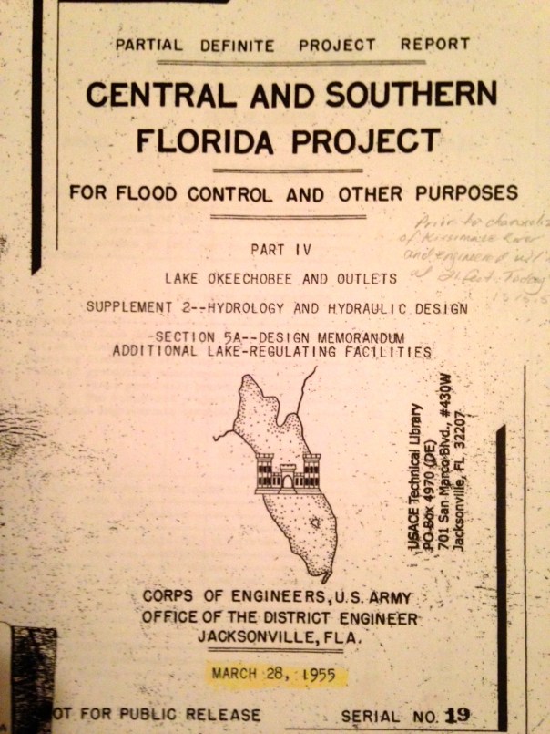


