Ed’s Aerial Update, 7 days after discharges begin 500cfs SLR

Ed Lippisch

Due to high Lake Okeechobee level and in light of cyanaobactia blooms predicted on lake this summer -a side effect of Category 4 Hurricane Ian- the U. S. Army Corp of Engineers, with the support of the SFWMD on 1-22-23, began discharging 500 cubic feet per second to the St Lucie River/Indian River Lagoon on January 22, 2023 and 2000 cfs to the Caloosahatchee to lower a lake not receding.

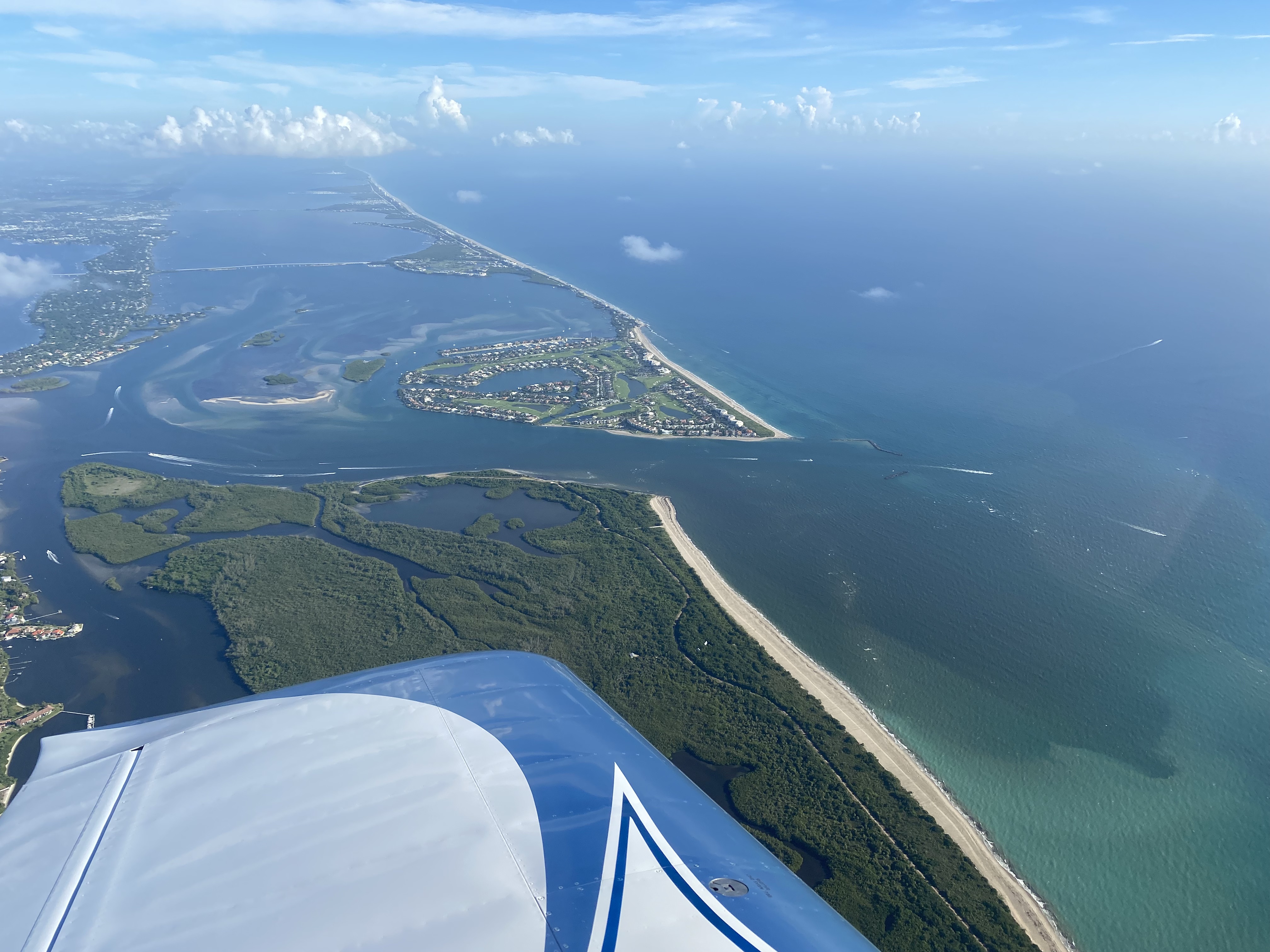
Yesterday, on January 29, 2023 my husband, Ed Lippisch, flew over the St Lucie River to see how the estuary is visually faring after seven days of discharges. He captured the images  around 2pm so it was what he calls a “slack tide,” a tide in between high tide and low tide.

Today I share Ed’s aerials, the effects of discharges is obvious and to compare to a pre-discharge high tide and low tide taken on January 22, 2023, before the discharges reached the estuary, please see link above and go to end of blog post.

I cannot thank my husband enough for all of his flights and dedication as a River Warrior of the St Lucie River. He continues to be our eye in the sky since 2013 and my best friend.

Tide chart St Luce River. Note January 29, 2023. Ed’s photos were taken beginning at 1:56pm.

Below:

Aerials of St Lucie River/Indian River Lagoon after 7 days of discharges from Lake O, note darker water and plume at inlet. Among other things, the discharges cause less light to reach the struggling seagrasses and a plume exiting the St Lucie Inlet covers already sick near shore reefs.

More CERP projects than ever before are being built to offset discharges to the estuaries and this is cause for celebration, but it will take years for these projects to all be completed and undo the horrible environmental consequence of the Central and Southern Florida Plan of 1948. Most recently, since 2018, the State of Florida under the DeSantis administration, has led the effort to stop harmful discharges to the estuaries under Executive Order 19-12 and now 23-06. Millions of dollars are being spent by state and federal government. We will get there.

Slide of expenditures, Everglades Coalition Conference 2023 presentation.

LOSOM, a new lake operations schedule of the ACOE, will help too and should be in place by mid summer. This was an effort of all stakeholders. An exhausting and successful effort.

The St Lucie has not had heavy discharges in over four years. At height in years such as 2013, 2016 and 2018, over 5000 to 9000 cubic feet per second were sent to the St Lucie. This present 500 cfs is an attempt to avoid such a situation this summer. To lower the lake before it kills us. I hate discharges but I rather take my medicine now than be destroyed  later. Also I  appreciate the ACOE for trying something different (HAB DEVIATIONS & LOSOM). I have been watching like a hawk since 2008, I can assure you we are in a better place due to advocacy changing the political landscape. Do not get discouraged!

Lake Okeechobee Lake Levels U.S. ACOE

To follow the most updated lake okeechobee levels go to Todd Thurlow, eyeonlakeo.com
Grey is environmental envelope for Lake O. It is to be seen what the goal is for lowering the lake and decisions will be made weekly by ACOE.

Lake O Discharges 2023

St Lucie Canal, aka, C-44 at S-80, Ed Lippisch 1-22-23. ~Discharges began by ACOE from Lake O at 500 cfs on 1-22-23. For comparison, at worst times 5000 to 9000 cfs flooded the St Lucie on and off in 2013, 2016, 2018. 500cfs (cubic feet per second) is not good, but it is not high-level discharges. JTL

The St Lucie Canal, also known as, the C-44 Canal, is the property of the U.S. Government. Martin County public records show that in the early 1930s, as a result of the 1928 hurricane, the right of way of the Everglades Drainage District was taken as part of the Okeechobee Waterway.

The U.S. Army Corp of Engineers holds jurisdiction and decision making over the canal and the water that flows through it from basins and Lake Okeechobee. Since the great flood of 1947 and the creation of the Central and Southern Florida Plan, there has been a “local partner” in decision making. That partner today is named the South Florida Water Management District, formerly the Everglades Drainage District…

In a modern world, every week, there are conditions calls regarding Lake Okeechobee and the environmental envelope, etc.  As in all things, these calls start with the “higher ups” and then end with a public call. The public call is the ACOE Periodic Scientist Call. During this call, stakeholders share conditions and concerns from all over south and central Florida. Most participants are government people or elected officials, but also heads of NGOs and members of the public chime in.

Grey is environmental envelope for Lake O

The process generally works as such: after all these calls, the SFWMD, the local sponsor, puts out an operations statement or recommendation to the ACOE. All of this information is available on line, but its like trying to find a needle in hay stack.

SFWMD Ops_Position_Statement_Jan_17_23_2023

Of course the ACOE and the SFWMD have been communicating all week. At the end of the day, because the U.S. ACOE holds jurisdiction over the C-44 Canal the ACOE is the final decision maker. More than ever, though, they are listening and even seeking public input. This is refreshing!

Pulse to average 500cfs -releases to the SLR from LO, via ACOEO and https://eyeonlakeo.com, Todd Thurlow

The ACOEs has been announcing their decision on the Jacksonville District’s media call on Friday of the week of all the other calls. This past Friday, the day after the SFWMD operations report was submitted, and all the “calls”, January 20, 2023, the ACOE held its media call, and the decision to start discharging from Lake Okeechobee was made make Col. Booth.

https://www.usace.army.mil/About/Leadership/Bio-Article-View/Article/2768770/col-james-l-booth/

Going back a couple of years, Col. Kelly, at the ACOE, came up with an operations plan called a HAB DEVIATION or Harmful Algae Bloom Deviation. This was done after Governor Ron DeSantis put forth Executive Order 19-12 that did all possible to avoid harmful and toxic discharges to the northern estuaries, St Lucie and Caloosahatcee, as years 2013, 2016 and 2018 had been disasters. HAB DEVIATIONS, like all things Army Corp, is engineering-like and complicated, but goal was to allow a deviation from lake operations (LORS or LOSOM) if there was algae in the lake or it was possible there could be algae in the lake, like after a Category 4 hurricane stirs everything up and brings massive runoff…

I am not sure if what the ACOE is doing now qualifies as a technical HAB Deviation, but it is certainly in the spirit of one. Both SFWMD and ACOE have stated they are expecting a large post Ian cyanobacteria blue-green algae bloom in Lake Okeechobee this summer. High lake water in summer would set off releases so they are hopefully dodging a bullet by lowing the lake now.

Due to Hurricane Ian, a Category 4 storm, that obliterated the lower west coast of Florida, coming in just north of Sanibel Island and Ft Meyers, Lake Okeechobee has risen four feet since September 28, 2022 cresting at around 16.47 feet. Because the Herbert Hoover Dike was almost complete, the ACOE did not discharge right away. If the lake had been at the 15.50 limit as before dike completion, there would have been discharges, input or no input.

Yesterday, January 25, 2023, was the ribbon-cutting for the Herbert Hoover Dike Rehabilitation. It took eighteen years. This does not mean there is unlimited allowance of water in Lake Okeechobee, but it allows for more flexibility as will LOSOM. Sediment has been settling in the lake since September/October.

I for one, appreciate the flexibility of the ACOE. In the old world when I entered in 2008, they just followed the book and opened the gates toxic algae or no toxic algae. Now there is awareness and thought. And water quality remains the responsibility of the state. If the ACOE believe/agree a HAB deviation is necessary after a Category 4 hurricane in order to try to avoid toxic discharges in summer when the lake often cooks into a toxic soup, I am all for it. I do not want to go through those type of years again!

These charts below from my brother Todd’s eyeonlakeo.com website show how water was discharged to the St Lucie in 2016, 2018, 2021, and 2022. Although the ACOE is discharging at 500 cfs average now to the SLR, all will be done to avoid another “Lost Summer!”

2016 Lost Summer 2

2018 Lost Summer 3

2021 nice summer even with LO releases (green)

2022 great summer, no releases LO

Photos of Ed Lippisch taken on Sunday, January 22, 2022, the day the 500 cfs discharges began to the St Lucie. These photos are baseline photos to compare to the future. I takes a day or more for discharge water to reach the St Lucie Inlet. The differences in these photos is due to tide and light.

SLR/IRL 1-22-23 at 11am, Ed Lippisch

SLR/IRL 1-22-23, 5:45pm

Part III -The Boon of the Huge Monster Ditch, St Lucie Canal

-Stuart News 50th Anniversary Edition, 1964.Today I will complete part three, the final portion of my transcription of an historic 1964 Stuart News, anniversary edition from my mother’s archives. She actually shared this article with me over a year ago and I was so taken by it that I thought it may be an inspiration for a book. I never got around to it, thus now I am sharing on my blog as part of my 2023 new year’s resolution to write more and learn more about the St Lucie Canal. 2024 is the official 100 year anniversary of the St Lucie Canal according to the Department of Environmental Protection.

Here are links to Parts I and Part II.

~Interesting references in part three of the article are the mentioning of a “release canal,” south to the Everglades, something that never materialized; reference, once again, to cutting edge “scientific water control” and the amazing success of the agriculture industry; 1933 noted as the first extreme discharge year from Lake Okeechobee to the St. Lucie River and damaging effects to fisheries and tourism; and in the final paragraph, a future plan linking a new “C-23 Canal on Martin County’s northern border with a major channel which would extend westward to Lake Okeechobee, with a side link to St Lucie Canal, and another channel from St. Lucie Canal southeastward down toward Pratt & Whitney and the Loxahatchee Marshes;” Gulp!

This is a reference to part of the canal system proposed in the 1948 and many following editions of the Central and Southern Florida Plan that thankfully was never built. This reference also leads me to believe that I was incorrect in part two when I wrote the article was written around 1937 or 1920 in part one. With these references to C-23, the article must have been composed after the great flood of 1947 as it is referring to the Central and Southern Florida Project of 1948.  I am learning all the time as I sludge through this stuff. The St. Lucie Canal has had so many face lifts! It is hard to know what cut they are referring to!

~As we learn, we are more informed and able to change the future of this huge “ditch” that has defined, benefited, and destroyed the region of our St Lucie River.

So here is a transcription of Part III.

I have entitled my post “The Boon of the Huge Monster Ditch, St Lucie Canal,” as both terms “huge” and “monster,” are noted in full article. To me, the canal is a monster continuing to haunt and terrify. And just like in the movies, I know that until I meet this monster face to face, it wont go away. I hope you will encounter it with me.

You can click on images to enlarge.

Begin transcript paragraphs 11-25:

The great hurricane of 1928, which drowned about 4000 persons in the Lake Okeechobee area, resulted in the widening and deepening of both the St. Luice Canal and the Caloosahatchee River as well as major outlets from the lake. The widened and deepened canal was officially dedicated at ceremonies headed by Secretary of Commerce, Daniel Roper on March 22, 1937.

In the intervening years, the canal’s “good and bad” points have been the cause of growth in the agricultural lands of the interior and of damages to the fisheries and resorts on the coast in periods of excessive discharge. Today, as ever since 1933, when the first heavy discharge from hurricane rains was experienced, efforts are under way to so shape the discharge so that the canal’s benefit can be enjoyed without attendant harm. The U. S. Engineer Corp’s plans for a higher lake level by diking the entire lake may result in less necessity for discharge and a long-range plan has been advanced for diversion of excess water to Everglades National Park by means of a relief-valve canal.

However in the half century which has ensued since the canal was approved, one indisputable fact not clearly seen in the beginning has emerged stage by stage to justify it.

It is “scientific agriculture by water control.”

Thousands of pleasure craft and hundreds of barges, shrimp boats, and other commercial craft use the waterway today, but it never did develop into the “thriving artery of commerce” that was predicted in which ocean ships would sail up to Stuart and load the products of the Everglades Empire brought to the coast by the St. Luice Canal.

Nor did a plan advocated during World War II jell out to make it a major barge and oil transport canal to escape the submarines which infested the Straits of Florida, Yucatan Channel and the Gulf Stream.

What did “jell out” was an expansion all along the route of the the scientific water control for agriculture that was  proven at Port Mayaca by that pioneering agricultural beginning in 1925.

G.C. Troup and Troup Brothers at Indiantown on their former 20,000-acre holdings, demonstrated that the combination of irrigation and good drainage would unlock agricultural riches. Today the Minute Maid and Hood corporations are among the huge citrus firms which have planted some 10,000 acres of new citrus and the largest lemon grove in the world on former Troup lands and lands opened to agriculture through water control by P. L. Hinson and others.

On both sides of the St. Lucie Canal, in the entire twenty-five miles of its length, there are spreading pastures, ranches where blooded cattle graze, and the Indiantown area also has some of the country’s largest diaries.

The Bessemer firm that proved it could be done is “in there pitching” with some of the most outstanding modern developments including Westbury Farms 1, 2, and 3, the new Westbury Farms Valencia Groves on the south side of the canal, and the spreading Green Ridge Groves on the north side. George Oliver who manages the giant spread and Michael Phipps of the major corporation are proud of the agricultural and ranching growth but prouder still of St. Lucie Training Park, unique race horse training facility where, “hopefuls” of some of the nation’s top stables get their “running” starts.

They can be found at dawn watching the work-outs on the oval track. Both are skilled polo players.

“Scientific water control with ample supplies from the St. Lucie Canal, and drainage into the canal, is the key to our county’s solid growth,” commented Oliver.

Currently being pushed by Martin County agricultural interests is a new over-all water control plan for the county which would spread the advantages of irrigation and drainage to areas not continuous to the St Lucie Canal.

The new plan would link in C-23 Canal on Martin County’s north border, where huge  citrus planting have recently been made, with a major channel which would extend westward to   Lake Okeechobee, with a side link to St Lucie Canal, and another channel from St. Lucie Canal southeastward down toward Pratt & Whitney and the Loxahatchee Marshes. Private landowners would link in with these new canals by irrigation pumps and drainage outlet as they have done along the St. Luice Canal.

-End of transcript and article JTL

Ed’s St. Lucie River Update, January 15, 2023

-Eye in the sky since 2013, Ed Lippisch I am going to keep this blog post short as I already wrote another today. Yesterday, 1-15-23, at around 1:45 pm, Ed took aerials over the St Lucie River/Indian River Lagoon. As it has been cold and windy the past few days there has been a “Beach Hazards Statement” from the National Weather Service. In Ed’s photos, the rough, turquoise, incoming ocean waters make for a stark contrast against the darker waters of the river. I believe the ocean waters are full of sand and that is what gives the aerials the milky, almost iridescent coloring. Hopefully, the sand is not burying the dormant seagrasses in the Sandbar and Sailfish Flats. Thankfully, there is no dumping from Lake Okeechobee at this time although the river is receiving the other C-Canal water and runoff. I’ll get Ed up in the plane again soon as I have not yet flown in the Van’s RV -and I am not planning on it! 🙂 JTL

SFWMD canal and basin map.

Added 1-18-23. ACOE’s Periodic Scientists Call -Power Point 1-17-23. Periodic_Scientists_Call_2023-01-17

Part II: The Boon of the Monster Ditch, St. Lucie Canal

Today’s post is the second part of a story. A story from the 1964 50th Anniversary Edition of the Stuart News. Signalizing Half a Century of Growth and Progress in Martin County, Florida.” It is a huge special edition newspaper, 110 pages!

The article I am sharing is on page 6-H and is titled ” St. Lucie Canal Approved in 1914, Is Boon to Agriculture Here. Huge Citrus Growth Along Water Route; Mayaca Groves First.” I feel this remarkable article given to my mother for her history archives by family friend and real estate man, Ronnie Nelson, must be shared. As the 100 year “anniversary”of the St. Luice Canal is next year in 2024. At this time, I must state I am finding many different dates as to the completion date of the canal, but at this point I am sticking with an article from the Department of Environmental Protection, 1916-1924. (Ecosummary 2001, C-44 Canal)

Learning about the St. Lucie Canal can be confusing because it was “rebuilt” or “improved”  and, believe it or not, “celebrated” a few times. I think this article included in the 50th anniversary edition was written as the canal approached its second rebirth in 1937.

There is so much to learn about how the St. Lucie Canal was perceived in earlier times. And it is only through understanding the past, that we can create a better water future for today and for tomorrow.

Part I  Paragraphs 1-4 

Part II, transcription continued, paragraphs 5-11

1964 Stuart News, 50th Anniversary Issue, Thurlow Archives
1964, Stuart News 6-H and 7-H

Transcription begins:

“The completion of this monster ditch will mean much for the Everglades, for south Florida in general, and for Stuart in particular. The improvement of the St. Lucie Inlet and harbor will thus make Stuart the gateway to the Everglades, and millions of dollars worth of agricultural timber, fish, and livestock products will pass through the canal transferring at Stuart onto ocean-going vessels. The canal is, according to contract, to be completed in four years.

First tangible result of the canal for large-scale agriculture was the pioneering effort of the Port Mayaca development back around 1925, created by Bessemer Properties, Inc., a Phipps company which saw the opportunities for agriculture through scientific water control by tapping on to St. Lucie Canal with pumps to provide irrigation in dry spells. At the same time, a series of canals discharged excess water into the canal during wet spells.

Port Mayaca Valencia orange groves today represents the first big-scale successful planting of citrus in Martin County.

Port Mayaca could well be said to be the test plot on which millions were spent to prove, by trial and error, with the best possible scientific agricultural advice, what could be done by enlisting the aid of the man-made waterway.

Paul M. Hoenshel, now a resident of Stuart, was the first agricultural manager in the Port Mayaca development. He was backed by the vision and guidance of such able Phipp’s representatives in Florida as Paul R. Scott and Roy M Hawkins, as was Thomas Gartland when he took over the management in later years.

Port Mayaca was an outstanding “first” because it squarely faced up to the fact that the problems of drainage and water control must be solved if agriculture was to be successful in Martin County. The Phipps interests took the property of several thousand acres and divided it into forty-acre fields separated by drainage ditches, roads, and windbreaks.

About 100 miles of those ditches were dug in the Port Mayaca development, all linked by giant pumps to the life saving waters of the canal. Since Port Mayaca contained both muck lands and sand lands, it was an ideal test tube not only for for its initial 600 acres of Valencia oranges but also for various truck crops, gladiolus- then a major flower crop before chrysanthemums came along- and for experiments in the right grasses and mineral additives to make pasture lands where livestock could thrive…”

~End of transcription. To be continued. JTL

Google Maps 2023 shows Port Mayaca’s location on/near Lake Okeechobee, in Martin County, FL. Blue Dot is area of confluence of St Lucie River/Indian River Lagoon leading to St Lucie Inlet.

Article about the history of Port Mayaca and Cypress Lodge by the late historian, Alice Luckhardt.

Visual Seagrass Comparison -August 2022 to January 2023 SLR/IRL

After a stretch of hurricane and rains since October 2022, the St Lucie River/Indian River Lagoon is clearing up. The river has endured the “usual suspects” C-44 basin, C-23 canal, C-24 canal, and stromwater runoff; however, luckily no damaging discharges from Lake Okeechobee.

With my husband Ed’s most recent flight, I was pleased to see the blue, clear waters returning to the Sailfish Flats and surrounding waters of the St Lucie Inlet in the vicinity of Sewall’s Point. But I was surprised and a bit disturbed to see a “seagrass desert” once again. Of course seagrass, like all plants, is more abundant and lush in summer months, but to see “nothing?”  This seems strange. I need to get in the water with a mask for a closer look!

Let’s compare two photographs, one taken in August 2022 and another taken in January 2023.

I. AERIAL TAKEN January 8, 2023. Water looking clearer but no visible seagrasses.

II. AERIAL TAKEN AUGUST 26, 2022.  This photos show regrowth of seagrasses.

As the August 26, 2022 photograph shows, seagrasses had rebounded in the southern Indian River Lagoon after years of damaging discharges. The worst recent Lake Okeechobee discharges were between the years of 2013 and 2018.

St. Lucie seagrasses are critical water and wildlife habitat. Especially as the seagrasses in the central northern lagoon have disappeared at such an alarming rate that a high number of manatees have starved to death.  

In recent years FWC has been feeding Indian River Lagoon manatees romaine lettuce as they have no secure seagrass food source. This is not sustainable. All political policy must specifically support the betterment of water quality and the return of seagrasses of the Indian River Lagoon. This began yesterday with an Executive Order  of Governor Ron DeSantis. See section 2.

-ALL OF ED’S AERIALS January 8, 2013, around 12:30pm.

-EXTRA and WONDERFUL NEWS. Click on photos to enlarge.

The next day, January 9th, Ed went flying with artist and friend Geoffrey Smith to relocate a very endangered Right Whale and her calf that Geoffrey had spotted in the Hobe Sound area just south of the St. Luice Inlet, on January 8, 2023. With his permission, I am sharing Geoffrey’s photos.

Wonderful news that our St Lucie is looking better. We must continue to take the protection of seagrasses and water quality seriously.

-Photos and mapping of Right Whale and Calf off of Hobe Sound in Atlantic Ocean.  Geoffrey Smith, January 9, 2023.

AREA CANALS DRAINING TO SLR/IRL

SFWMD canal map showing canals that drain lands and thus negatively affect water quality in the St Lucie River.

“The Boon of the Huge Ditch,” St Lucie Canal

Today, we will continue to study an article of a 1964 50th Anniversary Edition of the Stuart News from my mother’s history archives. We are doing this in light of the upcoming 100 year “anniversary” of the St. Lucie Canal.

The title of the this article, published originally in the 1920s is “St Lucie  Canal, Approved in 1914, Is Boon to Agriculture Here. Huge Citrus Growth Along Water Route; Mayaca Groves First.” In 2023with all of our water quality issues it is hard to imagine supporting the digging of this giant ditch. Back in the 1920s, it was a promise for a better future.

Looking west towards Lake Okeechobee. St Lucie Canal meeting the south fork of the St Lucie River c. 1920s. Thurlow/Ruhnke Collection.

TRANSCRIPTION, first 4 paragraphs of Stuart News 50th Anniversary Edition, 1964, page 6-H. JTL

“The St Lucie Canal, a twenty-five  mile artificial river tapping vast Lake Okeechobee, was originally approved back in 1914 as a drainage and navigation outlet from the lake, with great accent upon its commercial use as a barge waterway, but few foresaw that its greatest boon would be to agriculture. Digging began in September 1915, with dredges starting at the lake and working eastward.

Excerpt, Stuart News Anniversary Edition 1964.

The land from Stuart westward to the mysterious lake was a wilderness supporting a few scrub cattle and a few patches of “hit-and-run” tomato farms which were frequently drowned out or parched. Small scale citrus plantings, attempted on ten-acre tracts west of Palm City and Port Salerno were bringing heartbreak because of a lack of water control. There was either too much or too little.

Back on November 5, 1915, the Stuart newspaper reported the work of digging the huge St. Lucie-Okeechobee drainage and shipping canal is progressing nicely and is being hurried along with night and day shifts. Two dredges are employed in the work, each operating from the Okeechobee end. The small dredge, which precedes the larger, is now about one and one-half miles from the lake, and is advancing at the rate of about 600 feet a day. The large dredge which completes the actual work of digging the huge ditch has reached a point about one and one-half miles from the Okeechobee end and is excavating dirt at the rate of about 10,000 cubic yards daily. If this rate could be maintained constantly work would be finished in a year. Actual digging operations on the canal have been in progress for about five weeks. It is probable, the the Furst Clark Construction Company, the contractors, will also put a dredge at the St Lucie end of the canal so as to expedite the work, although no definite announcement to this effect has been made.

Manuscript Collection, courtesy, Florida Memory https://www.floridamemory.com/items/show/335255
Dredge “Culebra” on the St. Lucie Canal in the Everglades Drainage District, 1925.

The St Lucie Canal will be the main control canal of the immense Everglades drainage system, the largest drainage project in the world. The huge ditch will be twenty-five miles in length. 200 feet wide at the top, 160 feet wide at the bottom, with a maximum depth of twelve feet. It will empty into the south fork of the St lucie River six miles above Stuart, the waters reaching the Atlantic Ocean through St Lucie Inlet about the same distance southeast of Stuart. Indications are the digging operations will now go steadily forward until the completion of the canal and that no further hitch up will result  as the Internal Improvement Board of Florida and the United States War Department have come to a thorough understanding…” 

-End of transcription.

Florida Geology Collection, courtesy Florida Memory, https://www.floridamemory.com/items/show/124753
People along the Saint Lucie Canal near Indiantown. Note sand. Unlike other canals  constructed, at least partially along the alignment of natural creeks or rivers, the St. Lucie Canal winds through uplands with no natural drainage patterns (SFWMD historic timeline). The St Lucie has/had no natural connection to Lake Okeechobee.

The St Lucie Canal, now known as the C-44 Canal since becoming part of the Central and Southern Florida Project of 1948, runs from Lake Okeechobee to the South Fork of the St Luice River. The canal/ditch allows for both “basin runoff” (historically almost all of this water flowed south to the Loxahatchee system attached to the Everglades) and  Lake Okeechobee’s waters to be directed through the St Luice River. The “ditch” is also designed to flow backwards into the lake if the lake level is lower than the canal level.

The infamous St Lucie Canal in spite of its “boon for agriculture and Everglades drainage” has been, and continues to be, the most controversial canal in Martin County (in 1925 Martin County was created from Palm Beach County and a smaller part of St Lucie County) due to its potential for immense, longstanding, economic and environmental damaging discharges to the St Lucie River.

Thankfully and ironically, progress by the same entities that built this huge “ditch” is being made by the modern  Army Corp of Engineers (referred to in the historic Stuart News article as the United States War Department) and their local partner whose origins go back to the 1905 Everglades Drainage District now the South Florida Water Management District.  Yes, modern progress is being achieved through the Indian River Lagoon South portion of the Comprehensive Everglades Restoration Plan. As we know, times change and so does the definition of what brings a better future!

As we work to improve the system it is important to understand the perceived positive and negative consequences of the history of this “ditch.” I will be writing a lot about the St Lucie Canal this year, as mentioned at the beginning of this post, next year, 2024, will be the official anniversary of the St Luice Canal.

Google Maps today in 2023. The red bubble is near Indiantown. The St Lucie Canal runs from Lake Okeechobee to the St Lucie River and out to sea at the St Luice Inlet, near blue dot. The St Lucie “ditch” cut through uplands of narrow strips of pine flatlands interspersed with hammocks, ponds, sawgrass, wide prairies, sloughs and cypress trees, severing the natural flow south of water from Allapattah Flats and connected lands that once drained almost entirely  into the Loxahatchee/ Everglades system that also has been severed.

Study of this historic article is to be continued…JTL


Coming to Terms With a Painful Environmental History-St Lucie Canal 1913-1937

-Part of a series leading up to the 100 year anniversary of the St Lucie Canal (built 1916-1924) as we continue to work to understand and heal this waterway…

-Left side of 1913 east coast drainage blueprint, Florida State Archives -Right side of huge 1913 east coast drainage blueprint, Florida State ArchivesTwo days ago was the first day of 2023. As there is always a chance we will once again be tortured by the “C-44 ,” now seems like a good time to review it under its original title: the St Lucie Canal.

The above blueprints are from the Florida State Archives and they are enormous documents. Ed and I visited Tallahassee in order to lay eyes on these remarkable pieces of history. Laid out on a large table in the library one can piece the two pages together to read:

Territory From lake Okeechobee to the Atlantic Ocean,

Between Townships 37 and 43 South,

Showing Routes Examined for Proposed Drainage Canals,

Made Under the Direction of F.C. Elliot,

Acting Chief Drainage Engineer, March – April 1913.

The St Lucie Canal was built by the state of Florida’s Everglades Drainage District from 1916 through 1924 when Martin was Palm Beach County. Over the holiday I read through some of my mother‘s historic newspaper articles. They were sobering.

A 1923 Stuart Messenger headline reads “Wednesday Next is the Day Set for First Flow of Water From Lake to River Through St Lucie Canal.” It sounds a bit like today, fishermen and tourism had major concerns, but the chamber of commerce folk celebrated with visions of expanded inland agriculture and a port of commerce. The truth of the matter is that the primary reason for the St Lucie Canal, since Florida’s earliest fantasies, was drainage.

In fact most bragged about it. An April 29, 1920’s Stuart Messenger article expressed with pride: “The St Lucie is the main control outlet for Lake Okeechobee.”

On July 7, 1923, the same paper wrote: “the St Lucie is the key to the entire Everglades drainage project.” On November 6, 1931, not long after the deadly hurricane of 1928, The Florida Developer printed something that today makes me sick to my stomach:  “The east locks of the St Lucie Canal were closed Saturday, after being open nearly two years. In that time the level of the lake has been reduced from 18 to 14 feet.” 

Unbelievable! Four feet off the lake through the St Lucie!

In 1937, the year the St Lucie Canal was federally rededicated as part of the Cross State Canal to Ft. Meyers -another jaw breaker. In a 1937 February 27 Stuart Daily News article written by famous journalist and horticulturalist Edwin A. Menninger it reads: “…work on the St Lucie had begun when the pioneers realized the that canals through muck lands were unless as they refused to carry water out of the lake. Four of them had been dug and were utterly worthless. The St Lucie Canal was completed in 1924 and for 13 years has been the only functioning outlet from Lake Okeechobee to the sea.”

The St Lucie Canal the only outlet for 13 years?! No! Kill me please!

A Daily News Article of the same day has a title reading: “New Ortona Locks to Alleviate St Lucie Flow.”  According to this article, apparently until made part of the Cross State Canal’s Okeechobee Waterway in 1937, the Caloosahatchee’s drainage of Lake Okeechobee had not been functioning at least since 1924. 13 years! 

Upon reading through these old articles, I just about cried. I drank a lot of wine. I have studied this for years but nevertheless. And there were more articles…

The worst was a Stuart News January 9, 1964 anniversary issue article, the year of my birth of all years. There is a photo is the upper right corner with a picture, it reads again with pride: “Old Aerial View shows the island and lock formerly at Port Mayaca where the canal enters Lake Okeechobee. These works were removed in 1936 to give unimpeded discharge from the lake.”

They removed the structure at Port Mayaca so the most lake water could flow through? What’s wrong with you people?!!!!!! No!!!!!

As I was losing my mind, my husband, Ed, pointed out to me that the lake was not polluted at that time. True, but nonetheless! Fresh water is a pollutant to a brackish system! No! Another glass please!

Excerpt, Stuart News Anniversary Edition 1964.

To think of all the destruction the St Lucie River has experienced! As written in the archive timeline in the hallways of the South Florida Water Management District whose official close date for the St Lucie Canal is 1925:

“Recommended by the Randolph Report and begun in 1916, …unlike other canals constructed at least partially along the alignment of natural creeks or rivers, the St Lucie Canal winds through uplands with no natural drainage patters. Its sole purpose is to channel excess water from the lake to the Atlantic Ocean.”

SFWMD timeline

In closing, there is some good historical news, if you click on the blueprints above and study them you will see that in the design work for 1913 there was a proposed canal from Lake Okeechobee trough the Loxahatchee to Lake Worth. Boy they are lucky that canal was never built.

After a long drive, Ed is reflected while taking my picture in front of the Florida State Archives, 2022.


Wrapping up 2022-St Lucie River Update

Tomorrow will be December 31, 2022. Today I share the most recent aerial photographs of the St Lucie River/Indian River Lagoon and even one around Lake Okeechobee.

It was a very cold Christmas season. According to the Stuart News, Stuart logged in at 39 degrees on Christmas Day! The cold system hovered for a few days causing intermittent rain and cloud coverage. These photos taken a few days later after it warmed up -on an incoming tide- reveal that since our last photo session, it appears the river is clearing up thankfully with no discharges from Lake Okeechobee in 2022.

AERIALS

-December 28, 2022 at 8:45am, west of Stuart, east side of Lake Okeechobee, near Barley Barber Swamp and FPL cooling reservoir, -sugarcane burning or a controlled burn??? Photographs taken by Scott Kuhns from SuperCub.

-December 29, 2022 around 2:30 pm, St Lucie River/Indian River Lagoon around St Lucie Inlet, Sewall’s Point, Sailfish Flats, wide view taken over Palm City. Aerials by Ed Lippisch from Vans RV. I am including all photos although some are very similar as each one shows something a little different. Remember you can click on photo to enlarge 🙂

Wishing everyone a very happy and safe New YearEve and let’s continue to work together for a great 2023 for the St Lucie River! 

A Florida River, St Lucie 1950-2050?

Looking up the North Fork of the St Lucie River towards what became Port St. Lucie 1957, Ruhnke Collection, courtesy Sandra Thurlow.

A Florida River, A Look at Wildlife 1950, by E.W. Dutton.

“This film shows a trip down the St. Lucie River with E.W. Dutton. Viewers see gators, blue herons, and many plants and flowers. The film also shows a red-shoulder hawk, sandhill crane, armadillo, black bear and cub, rattlesnake, land crab, and a gator being fed by hand. “Now a NO! NO! “Viewers see pelicans, mullet, cormorant, deer and a Florida panther.” ~Florida Memory.

Click on arrow below or the link here to view short film. 

Recently, my mother sent me this wildlife video filmed by E.W. Dutton, well known for his work of the St Lucie River and for area Chambers. His films bring one back to a time when not as many people lived here, and wildlife was prolific including animals unable to live along the river today such as deer, bears, and panthers. At this time the North Fork was a game sanctuary and conservation laws were respected in the South Fork.

E.W. Dutton, Ruhnke-Thurlow Collection

Wikipedia shows the population of St Lucie County as 20,180 in 1950.

And the population of Martin County as 7,807 in 1950.

The UF Bureau of Economic and Business Research projected population leads me to think that by 2050 there may no wildlife left anywhere in the region of the St Lucie River unless we curb development, work to “wild” our yards, work to live with wildlife rather that eradicate it, get more serious about highway over and underpasses and promoting and supporting the Florida Wildlife Corridor, including parts of Martin and St Luice County. Let’s make 2023 a turn in that direction! Kudos to the Loxa-Lucie Headwaters Initiative in Hobe Sound that added lands this year.

PROJECTED POPULATION COMPARED TO 1950 ST LUCIE RIVER REGION

St Luice County:  1950 population 20,180; 2020, 329,226; high projected  population by 2050, 601,400.

Martin County:  1950 population 7,807; 2020, 158,431; high projected population by 2050 – 277,700.

*Sources: Wiki and UF Bureau of Economic and Business Research

12-27-22 bio E. W. Dutton

Visual Update St Lucie River 12-20-22

I wanted to provide a visual update of the St Lucie River/Indian River Lagoon. Even though the river looks dark and silty, as 2022 comes to a close, we remain fortunate that there have been no major discharges from Lake Okeechobee to the St Lucie River since 2018 and no discharges to the St Lucie this year even though Lake Okeechobee got very high -maxing out at 16.51 feet.

Recently, there has been quite a bit of rain in Martin County. This follows the rains of Hurricane Ian and Hurricane Nicole. Thus the river looks dark and silty from weeks of runoff. The runoff now is coming from surrounding lands as well as C-23, C-24 and C-25 out in the IRL at Ft Pierce. There are also hundreds of old ditches that dump into the St Lucie River running though creeks such as Dansforth, Willoughby, Warner and others.

Thankfully the Indian River Lagoon South project is underway by the ACOE and local sponsor SFWMD to offset the destruction of the major canals of the Central and Southern Florida Plan. If things go well and the economy and political will remain in place, the remainder of these projects should be complete in ten or fifteen years. The C-44 Reservoir and STA in Indiantown, Martin County is complete.  Ten to fifteen years sounds like a long time, however, these  are gigantic, expensive  projects working to undo gigantic problems as our population skyrockets.

In the meanwhile we should be working on going septic to sewer where necessary and improving our yards by using little grass, fertilizer, or pesticides;  planting more native and Florida Friendly plants; using less water, picking up dog waste; and realizing everything we put on our laws or fertilize -crops and/or yard plants- ends up in the water ways! We have to be part of the solution. Don’t expect the government to do it all.

AERIAL PHOTOS ST LUCE RIVER UPDATE

Ed Lippisch, my husband, and Scott Kuhns, our dear friend, took the aerials  I am sharing today. The river does not look great due to so much rain. Thank goodness there are no Lake O discharges on top of this “local runoff.” Of which it really is not! This runoff has been mainlined here through canals of the Central and Southern Florida Plan.

SFWMD canal and basin map.

Next year they both Ed and Scott will have been River Warriors for ten years documenting the St Lucie! As eyes in the sky they provide a wider view and inspire a wider net of recovery for these waters. My brother, Todd’s web site eyeonlakeo allows for full time satellite and data updates.

SCOTT KUHNS, SUPER CUB, December 16, 2022 around 9:40 am. St Lucie Inlet (Hutchinson Island) plume about 12 miles south past Peck’s Lake, (Hobe Sound).

ED LIPPISCH, VAN’S RV December 18, 2022 around 12:15 pm. Plume at St Lucie Inlet, and dark runoff waters discoloring the entire estuary even close to the inlet around Sewall’s Point and Sailfish Point, Hutchinson Island.

Most recent rain as shown in my rain gauge. Just under 4 inches around December 14.

12-21-22 Added Presentation from ACOE Periodic Scientist Call: Periodic_Scientists_Call_2022-12-20

Drainage of Witham Field, Stuart

Images below from Todd Thurlow’s “East Ocean Blvd. & Dolphin Drive 1940, 1958 time capsule flight” reveals the drainage of  Witham Field in Stuart, Florida.For some reason as I drive around, I am preoccupied with drainage. Over-drainage that is. I always remember my father’s high school farmer friend Mr Haddad saying to me: “Jacqui, we spent one-hundred years taking the water off the land and we’re going to spend one-hundred years putting it back on…” 

I have been wanting to write something about Stuart’s Witham Field for a long time.  I have flown out of it for years, Ed and I going up to take photographs of the St Lucie River/Indian River Lagoon. What a surprise when I finally figured out the ditch behind Ed’s hanger is part of the remains of Willoughby Creek! Aggg!

The land Witham Field sits upon was ditched and drained long ago and parts of the land the airport sits on held the headwaters of Willoughby Creek.

If you’re ever driving east past Witham Field on Monterey Road (714) at Kingswood Drive you’ll notice a fairly wide ditch. This ditch bends east, widening, and then getting skinny again, eventually going under St Lucie Boulevard, and then dumps into the St Lucie River.

-Screenshot of Google Maps showing canal along Monterey and Kingswood Drive dumping to the St Lucie River then turning right to gold course.Another canal goes all along the airport behind the houses on St Lucie Blvd. until the Sailfish Sands golf course. Curving around St Lucie Boulvard, which becomes Indian Street, one will see a restored fork or section of Willoughby Creek and next the bridge going over Willoughby Creek itself. This is the bridge where people often observe manatees.There are more ditches that are off Dixie Highway that lead back into the airport that one cannot see from the road.

-The surrounding lands, especially ponds around Willoughby Creek, once drained into Willoughby Creek. These ponds are long gone and the runoff waters have been directed into small reservoirs and ditches. Thankfully, Martin County has worked hard to improve the water quality in this area.

Below: Martin County completed a storm water treatment area and native plant storm water treatment area for Willoughby Creek in 2020. (Image MC)

It remains rather amazing to look back and think on what these lands in the “middle of town” used to be. Large ponds surrounded by wetlands, scrub habitat, and certainly areas of tall sand and slash pine.

Watch my brother Todd’s time capsule flight below to view old Stuart including the lands where the Witham Field sits. Once an oasis for birds, deer, gopher turtles and other wildlife, today it seems like it was always an airport. It wasn’t. 

To see the area of Witham Field go to 2:29 in video if you see it below, if not   CLICK HERE.

-Ditch on Monterey (714) and Kingswood  -Ditch/Canal on Kingwood -Ditch/Canal coming from Kingswood to St Lucie River. Water looks pretty gross.  -Other side of St Lucie Blvd. Outfall into St Lucie River. It’s at a speed hump. -Part of restoration of Willoughby Creek on Indian Street. This goes much further back.

-Not a great photo but you see the manatee sign at bridge over Willoughby Creek on Indian Street. The manatees love it here where it is warm and they are protected.

Draining Palm City

My recent blog post featuring my brother Todd’s time capsule flight of Palm City 1966 Then & Now received great interest. So today I am going to take the subject a bit further in our study of area canals that drain wetlands into the St Lucie River.

If you have never seen the 1940s Aerial Photos UF Collection, you must! These historic aerials were taken when the United States had new-spy plane technology. They are our earliest comprehensive, aerial wetland accounts of Martin County, St Lucie County, and all of central and southern Florida. (All the dark in the photos is little ponds and sloughs!)

Just recently, through the help of archivists at the South Florida Water Management District, I was able to verify important historic information regarding canals C-23, C-24 and C-25. Again, these canals were constructed as part of the Central and Southern Florida Plan after the great flood of 1947. What is most interesting is that these canals were dug atop already existing local drainage ditches…

According to the SFWMD:C-23: “Acquisition began in April 1951 and concluded in 1961. There was an existing creek and ditch known locally as the Bessey Creek Canal. The Corp’s As Built Survey is dated November 18, 1964.

*I would think this local ditch had been dug by the Palm City Drainage District.

C-24: Acquisition began in August 1958 and concluded in October 1962. There was a existing canal know as the Diversion Canal, which was under the jurisdiction of the North St Lucie River Drainage District and they converted their interest in the canal to the SFWMD in August 1958. The Corps’ As Built Survey dates June 22, 1962.

NO PHOTO for C-25. (1940 aerials do not contain the Belcher Canal as the plane did not fly that far north. There are later aerials of the Belcher Canals after 1940, but I am sticking with 1940 today! the Belcher Canal, now C-25 is starts in Ft Pierce at Taylor Creek dumping into IRL.)

C-25: Acquisition began in October 1949 and concluded in September 1962. There was an existing canal known as the Belcher Canal, which was under the jurisdiction of Fort Pierce Farms Drainage District and they converted their interest in the canal to the SFWMD in January 1961. The Corp’s As Built Survey is dated July, 8 1964.”

Full view 1940’s Aerials  1 & 2

For me,  it is important to know the history of these canals. The C-44 south, and connected to Lake Okeechobee is our greatest water quality nightmare, however C-23, C-24, and C-25 are also extremely destructive. Yes, they allowed great growth of agriculture and development,  but they, as all the canals of the Central and Southern Florida Plan continue to killing our environment and the wildlife that once flew, roamed, ran, hopped, and dug freely, not to mention water quality issues.

The ACOE and the SFWMD are in the process of Northern Everglades restoration through the Indian River Lagoon South component of CERP.  This is wonderful news! We must be mindful of this before we continue to allow more growth and development and more drainage within these lands.

Indian River Lagoon South an overview

C-23/25 Recevoir & STA under construction


SFWMD basin map for SLR showing C-canals draining lands into the SLR.

Palm City, FL 1966 Then and Now w/ Todd Thurlow

Today’s blog post is about western Martin County Florida’s Palm City. This post includes  my mother’s inspiration, my brother Todd’s  time capsule flight video, and my writing.

Palm City was once narrow strips of pine flatlands interspersed with hammocks, ponds, wide prairies, sloughs, sawgrass and cypress trees. Today it is a bustling part of Martin County due to the drainage of the C-23 canal on the north, and the C-44 canal on the south. When one attempts to unravel the long history of drainage of Palm City, it is helpful to think in three connected but separate levels: local, state, and federal. 

In 1919  the Palm City Drainage District was created. It was established for a local level as a special drainage district by the Florida Legislature with a lifetime of fifty years. It was primarily created to drain newly established Palm City Farms. Miles of canals and ditches were dug to drain into Bessey Creek, Dansforth Creek, and the South Fork of the St Lucie River. Some of these canals and ditches still exist today or have been incorporated into larger canals.

Palm City Drainage District Docs. 1919

Digging of the St Lucie Canal in the south began around 1915  lasting into 1926. It was dug by the Everglades Drainage District, State of Florida, from the South Fork of the St Lucie River to Lake Okeechobee. After the deathly hurricane of 1928, the federal government authorized widening and deepening the St Lucie Canal to create the Okeechobee Waterway also known as the Cross State Canal from Stuart, across Lake Okeechobee, to Ft Meyers. Doing so allowed the St Lucie Canal to conveniently function as the main outlet for Lake Okeechobee’s flood waters. Later, after the great flood of 1947, the canal became part of the Central and Southern Florida Plan and renamed C-44 becoming part of the giant Central and Southern Florida Flood Control System of the Army Corp of Engineers.

The great flood of 1947 called not just for the widening and depending of the St Lucie Canal and enlargement of its structures, but the federal Flood Control Act of 1948 authorized more canals, levees, and structures  to be built by the Army Corps of Engineers throughout southern and central Florida. Among the new canals were the C-23, the C-24 and C-25 canals of Martin and St Lucie counties -all discharging into the North Fork of the St Lucie River. The state asked for and supported this. The C-23 is the border between Martin and St Lucie Counties. Of course there were major unintended consequences that added to the discharges of the St Lucie Canal and the original Palm City Drainage District. This plethora of fresh, dirty water has all but killed the St Lucie River. Improving the health of the St Lucie is the goal of local, state, and federal restoration efforts today.

The video below created by my brother Todd begins in 1966 after all the aforementioned canals were constructed. It is easiest to see in a large format. You can either click on the YouTube image below or use this link to watch this remarkable Palm City time Capsule Flight!

*Click on link to watch video by Todd Thurlow

-Below: the federal government’s (ACOE) Central and Southern Florida Flood Control Project authorized by Congress in 1948 included C-23 on the border of Martin and St Lucie Counties, C-24, and C-25,- and enlarging the flood control structure along the St Lucie Canal. Once this system was built out it was turned over the state of Florida’s Central and Southern Flood Control District; however, the ACOE kept the St Lucie Canal now named C-44, for federal flood control. The Central and Southern Flood Control District, a Florida state agency that followed the Everglades Drainage District in 1949, became the South Florida Water Management District in 1977. -Below: A 1973 C&SFP update map, Army Corp of Engineers. Green never built thank God!

Celebrating the 75th Anniversary of Everglades National Park!

Yesterday, December 3, 2022, Ed and I drove to Flamingo in Everglades National Park for a very special day, the park’s 75th anniversary celebration. It was unforgettable! Today I share the event program, historic postage, and some of my photographs.

The event featured an open house of the newly renovated Guy Bradley Visitor Center, a rededication ceremony with a list of impressive speakers including ENP Superintendent Pedro Ramos, live music by once Artist in Residence in Everglades, Grant Livingston, historic re enactments of Marjorie Stoneman Douglas,  Ernest F. Coe, Guy Bradley, May Mann Jennings, Ruth Bryan Owens, and John Pennekamp. Under a  blue sky and perfect weather the crowd looked out over Florida Bay and could see white pelicans, brown pelicans, and a plethora of other wading birds in the distance. The mood was jovial led by ZooMiami’s Ron Magill -master of ceremonies. Throughout the day many noted the moving speech of President  Harry S. Truman at the December 6, 1947 dedication of Everglades National Park in Everglades City. We walk in the footsteps of giants…

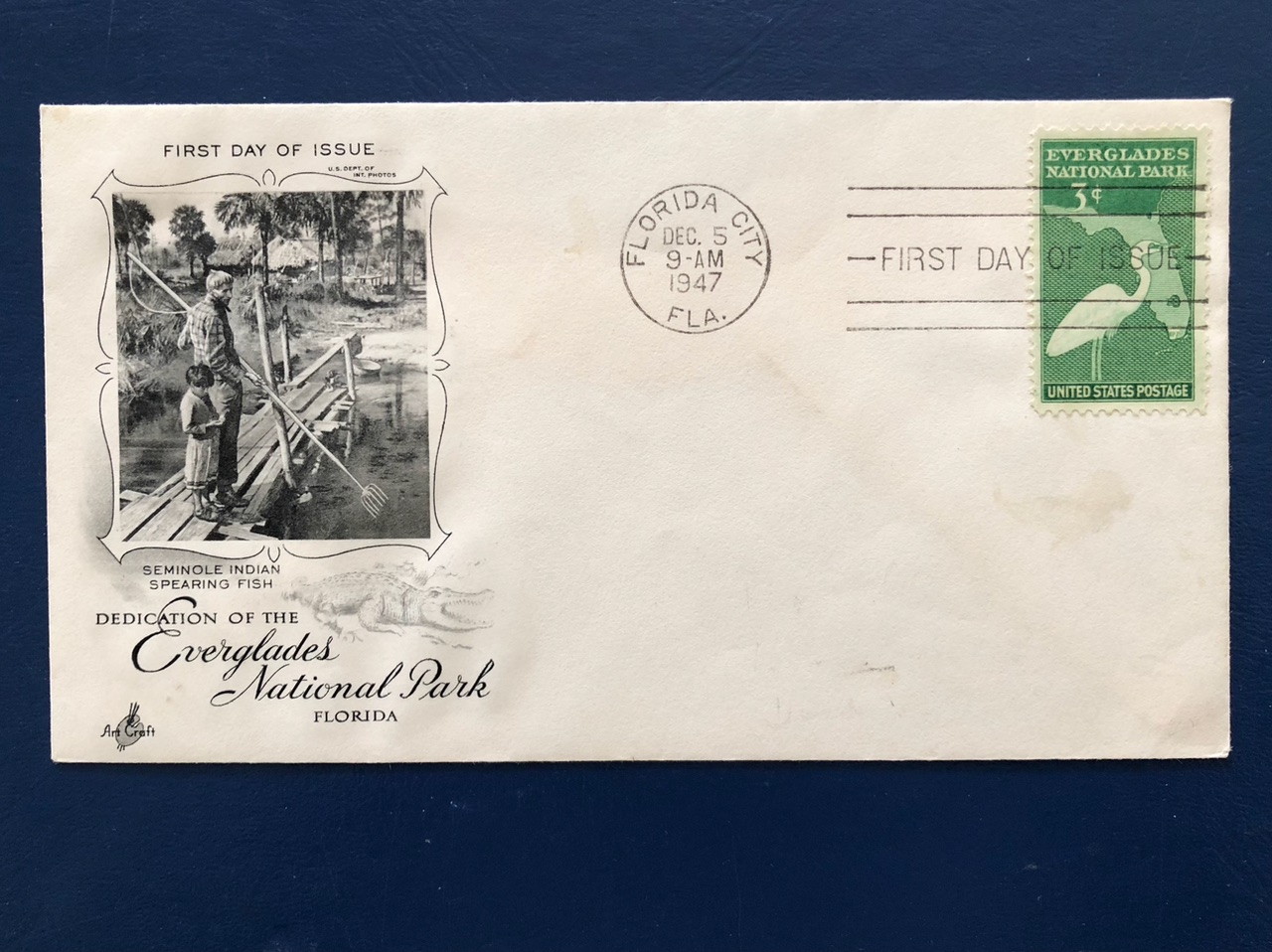
-Historic time-stamped 1947 Everglades City envelope and stamp in celebration of the dedication of ENP. From the stamp collection of the late Thomas H. Thurlow Jr., courtesy of historian Sandra Henderson Thurlow.

“Not so often in these demanding days are we able to lay aside the problems of the times, and turn to a project whose great value lies in the enrichment of the human spirit. Today, we make the achievement of another great conservation victory. We have permanently safeguarded an irreplaceable primitive area. We have assembled to dedicate to the use of all the people for all time, the Everglades  National Park…” –President Harry S. Truman December 6, 1947

It was wonderful to participate in this historic day in 2022 that so many before us worked so hard to attain. We all hold the baton for remarkable  Everglades National Park!

HAPPY ANNIVERSARY ENP! 

-Click on image to enlarge

-Order of the Day & List of Speakers -President Truman’s historic 1947 speech -Historic Figures  -Superintendent ENP, Pedro Ramos beaming on this special day! -with Craig Van Der Heiden PH.D and wildlife dept. Miccosukee Tribe of Indians of Florida -With Ernest Coe as portrayed by Mr Lee Jacobs.-Manatee drinking fresh water running down seawall, Florida Bay.-Mr and Mrs Chauncey Goss, Chauncey is Chairman of the SFMWD -together with Sean Cooley, Communications Director for the SFWMD. Drew Bartlett, Ex. Dir, Libby Pigman, Reg. Rep., her husband, and fellow governing board members Ben Butler and “Alligator” Ron Bergeron also attended. -Juan Cueto, Executive Director, The Alliance of Florida’s National Parks, Superintendent Ramos, and Maimi-Dade County Mayor Daniella Levine Cava.-Col. Jamie Booth speaks on behalf of the ACOE.-Reenactment: Mary Mann Jennings presented the bill for Palm Hammock and Paradise Key in 1915. -Historic display showing Great Egret plumes- destructive fashion for ladies hats in the late 1800s and early 1900s. Guy Bradley was killed as Audubon’s first warden trying to protect wading birds from this terrible fate.-Great Egret photograph showing a bird extending its plumes during mating season, public domain. What a  sight to behold!-Video reenactment of Marjorie Stoneman Douglas who wrote the famous book River of Grass.

-Grant Livingstone and Ernest Coe. Ernest Coe, the major inspirer for the park, almost did not attend the 1947 dedication as he felt the park should have been larger as originally planned.-Tina Osceola, Sup. Ramos, Debbie W. Schultz, Shannon Estenoz, Talbert Cypress, Ron Magill right. (See program for titles)-Rep. Wasserman-Schultz, Superintendent Ramos, and Assistant Secretary of the Interior, Shannon Estenoz celebrate the rededication proclamation of ENP.


A Child’s Dream -A Hunt for the 1715 Treasure Fleet’s Riches

It started about two years ago when Ed’s young niece and nephew, Capri and Cole, came to visit. On our trawler, Adrift, they found the map “Shipwrecks of Florida and the Eastern Gulf of Mexico.” They stared asking about shipwrecks and treasure and pirates. Ed and I had to study up.

“…The 1715 Treasure Fleet was returning from the New World to Spain. At two in the morning on Wednesday, July 31, 1715, seven days after departing from Havana Cuba, all eleven ships were lost  in a hurricane along the east coast of Florida. Today, we refer to this area as the Treasure Coast.

Every time Ed and I saw Cole and Capri thereafter, they asked again about the pirates, the gold, the ships at the bottom of the sea. So this time when the family came for Thanksgiving I told Ed it was time we lead a treasure hunt and then visit Mel Fisher’s Treasure Museum in Sebastian. We could teach the kids about the famous Treasure Fleet of 1715 featured in the 1965 edition of National Geographic where Kip Wagner and Mel Fisher’s Sebastian, Vero, and Ft. Pierce finds created “treasure fever” all over the world. I ordered an inexpensive treasure chest, false pieces of eight, and colorful costume gems. I visited thrift stores for beads. I thought about how the pieces of silver and gold were stamped in Peru and Mexico and that the Spanish had colonized these areas only steal the riches back to the crown…

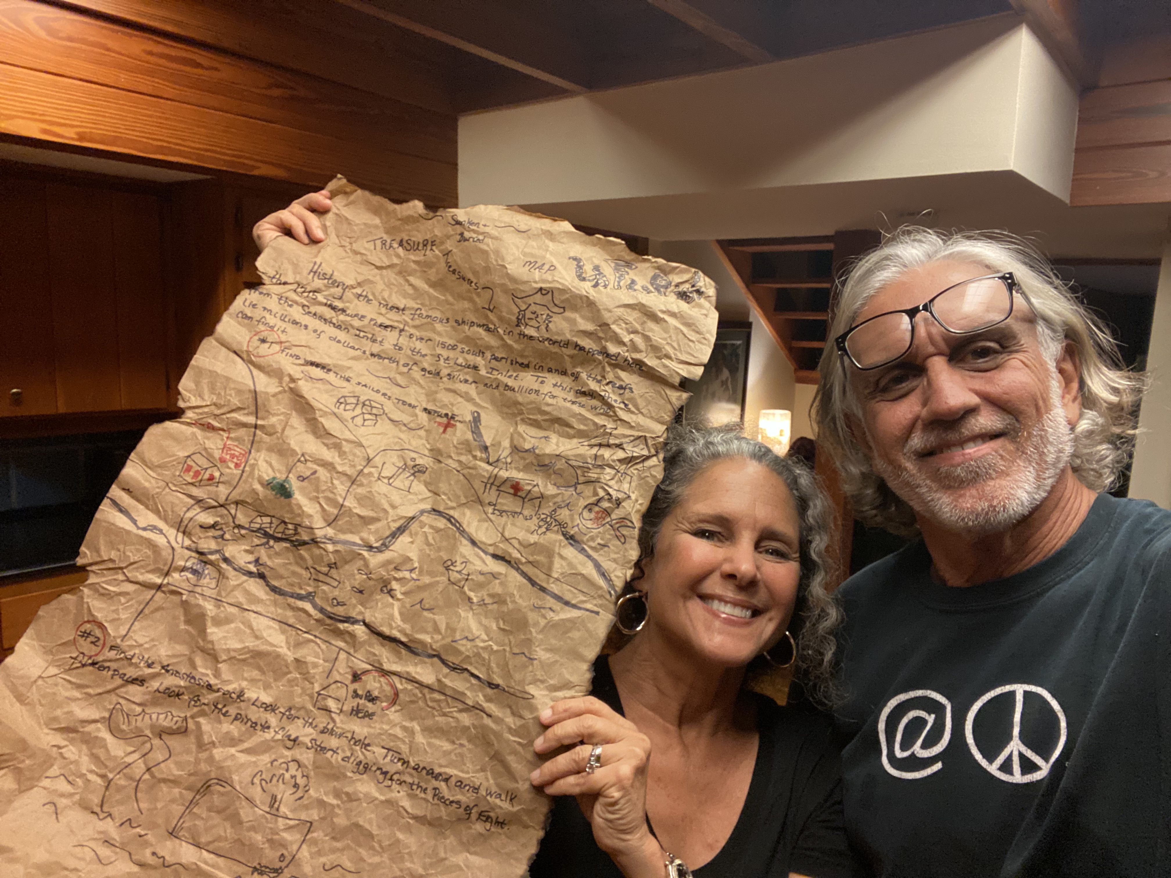
Ed’s first job was to crate a treasure map. He drew the figures and I wrote the history and clues. Ed even tore, crinkled, and burned the edges of the paper to make it look old.  WRITTEN ON MAP

History: the most famous shipwreck in the world happened here. The 1715 Treasure Fleet and over 1500 souls perished in and off the reefs from Sebastian to the St Lucie Inlet area. To this day, lie millions of dollars of gold, silver, and bullion for those who can find it.”

Clue #1 Find Where the Sailors took Refuge
Cule #2 Find the Anastasia Rock. Look for the Blow Hole. Turn around and walk fifteen paces. Look for the pirate flag. Start digging for the Pieces of Eight.

Ed’s second job was to go ahead of me and his family and bury the treasure chest at the House of Refuge. Ed did a heck of a job. Such a great job that once the kids found “X-marks the spot,” they dug, and dug, but could not find the treasure!

I was looking at Ed. I was glancing at Ben (Ed’s nephew) and Kelly (Ben’s wife). I couldn’t believe it!

“Ed!!!” I bellowed!

Although it was November, and Thanksgiving time, it was hot and humid.  A fog hung over Hutchinson Island as we drove over the Indian River from Sewall’s Point.

Now we all were getting nervous and Ed and Ben started digging for the treasure box. The kids stood by spellbound. It wasn’t as if they hadn’t given it a good shot.

-Ed and Ben taken over…-Cole tries to help.-Capri holds a map up for Ed to get a clue..“Well the kids moved the pirate flag and the metal bar I put over where I marked the booty.”  Ed whispered, so the kids would not hear. “Just find it! I replied.  “Keep the dream alive!”

Ben and Ed dug. And they dug. And they dug. This went on for at least fifteen minuets or longer. The hole was getting deep and I knew this is a “no-no” due to nesting sea turtles. I kept making Ben and Ed fill the hole back in. I heard a voice and realized the Keeper of the House of Refuge, Michael Philips,  had left his historic post to come outside and see what we were doing. I explained, apologizing. He laughed and was very kind.

Then it dawned on me that we may never find the treasure box. That it would sit and rot here at the historic house of refuge under the sands of time forever. The irony was unbelievable.

Sweaty and tired, Ed looked at me: “You’re going to kill me, aren’t you?”

I laughed and hugged him. “No, it’s actually very funny.”

Right at this moment Ben struck the treasure box. “Thump.” Cole and Capri screamed with joy and resumed their digging. Gold and silver coins were strewn across the sand as the kids fought to hold the bullion.  Success! Certainly a dream kept alive and that is all that matters.

Field Trip post treasure hunt:

-Mel Fishers Treasure Museum, Sebastian, Florida about an hour drive north of Stuart. You can take AIA where all the ships lie off shore! -The museum offer kids a fill in the blank treasure hunt questionnaire and once completed the kids get to choose a small gift from the gift shop. Carpi chose tiny binoculars and Cole chose a pirate ring. They also saw real pieces of eight and how expensive and beautiful the pieces were. This facilitated a lot of historical and present day conversation. -Capri and Cols stand before the 1876 House of Refuge, Hutchinson Island, Martin County. This setting was wonderful for our treasure hunt. Thank you!

-A scholarly article by Rick Crary about the 1715 Treasure Fleet. 

More Rain, but #NoLakeO, SLR/IRL

Thanksgiving was a whirlwind and a lot of fun as Ed’s family including niece and nephew visited. The two days before their arrival on November 22, 2022 was quite rainy -a light, humid, constant rain. After the “rain event” my rain gauge read just under 6 inches! Here along the coast in Sewall’s Point the old saying remains: “when it rains, it pours.”

Today, I am sharing my husband Ed’s aerials of the St Lucie River/Indian River Lagoon. They were taken area above Sewall’s Point, the St Luice Inlet, and a few of the Roosevelt Bridge in Stuart -on November 26, 2022 around noon on an incoming tide. Like my previous post , after Hurricane Nicole, the contrast of milky, stirred up ocean water and the dark, fresh, polluted, runoff from area canals and surrounding lands and neighborhoods is extreme.

In my opinion, to witness such events without the discharges from Lake Okeechobee is educational, it makes clear how important not fertilizing and using chemicals on our yards is, and thankfully the tides flush the mouth of the river out over time. When the ACOE starts Lake O discharges, this can go on and on – for months and in worst case scenarios -for years. The river cannot clean out. There have been no major, longstanding discharges from Lake Okeechobee since 2018 and the Sailfish Flats’ seagrass community has been slowly recovering.

Today the lake stands at 16.50 feet. There is a periodic scientists call today of the ACOE when input will be taken regarding lake discharges and other water issues.

Thus Ed and I present these photographs for the record.

-My rain gauge after the rains a few days prior to Thanksgiving on November 24, 2020. almost 6 inches.

-SFWMD Lake O update

-Canal map

SFWMD basin map showing canals that lead to the SLR. The C-44 can dump water in the C-44 basin or water from Lake O or both.

11-29-22 6:17pm slide from ACOE PSC at 2pm


Hurricane Nicole’s Ugly Effect – St. Lucie River/Indian River Lagoon

As shared in my recent blog post, Hurricane Nicole brought a significant storm surge to the St Lucie River and Indian River Lagoon region. Many residents experienced flooding and property damage, especially of docks and seawalls.

Today, 11-16-22, my husband, Ed, went up in the RV plane and took pictures to compare to others we took prior to Hurricane Nicole.

It has been quite a time. Nicole hit Florida on November 10, 2022 and Hurricane Ian on September 28, 2022. The river has taken two recent hits.

When Ed got home and I asked him how the river looked, there was a pause and he replied, “just like old times…” meaning “not good.”

Ed’s photos were taking during a rising tide around 1:15 November, 16, 2022. You will see that there is the flushing/cleaning of incoming ocean water from the St. Lucie Inlet. If the estuary is left alone, in time, a few weeks, it will significantly clear up. If the ACOE discharges from Lake Okeechobee, (the Lake is at 16.22 feet) it will not clear. Tomorrow’s (11-17-22) Rivers Coalition meeting at 11am at the City of Stuart Chamber, 121 SW Flagler Avenue, Stuart, Fl 34994, will address this issue, also the issue of “sending water south.” The guest speaker will be LTC Todd Polk. I encourage all to attend.

The goal? To allow the St Lucie River to return to her true beauty and that can only happen when we stop the discharges, all of them.

2-11-15 ACOE Periodic Scientist Call information: Periodic_Scientists_Call_2022-11-15

-Sewall’s Point between the SLR/IRL -click on to enlarge. -Ernie Lyons bridge from Sewall’s Point to Hutchinson Island- IRL–Jupiter Narrows far left, SLR-Plume in Atlantic Ocean coming out of St Lucie Inlet


We “All” Live in an Ancient Indian Archaeological Zone

-Erosion at Santa Lucea Beach, Martin County , FL  11-11-22, JTLJust a few days ago, Hurricane Nicole whipped up the Atlantic Ocean and unearthed an ancient Ais Indian burial site at Chastain Beach on Hutchinson Island, near Bathtub Beach and Sailfish Point. Once again, we are reminded of history and those who lived here before us. I would hope, in time, these remains will be sacredly reinterred.

11-12-22 TCPalm article “Hutchinson Island Burial Site May Have Exposed Bones”

It is important to note that the local native people of Florida did not just live on Hutchinson Island, they utilized our entire coastal area of the St Lucie River/Indian River Lagoon. In fact, almost our entire coastal region is designated an “Archaeological Zone.”

-Below: map insert section of Martin County, Florida coast. “An Archaeological Survey of Martin County, Florida, 1995.” The shaded areas denote archaeological zones – areas the native people especially lived in and utilized. This includes Hutchinson Island, Sewall’s Point, parts of Rio, Jensen, Stuart, Palm City,  Rocky Point, and Hobe Sound among others. This report was not just to map these areas but also to alert developers. What does this mean? It means that in 1995 the famous archaeologist, Robert Carr, and his team determined such, and this is documented in their publication written for Martin County Government. Ironically, I had just asked my mother for a copy for our study of Palm City so when the unearthing occurred I took note.

The publication  provides the following designating these Archaeological Zones.

I am reminded to share an old blog post of mine about the Indian Mound, still visible,  in Ft Pierce. Tuckahoe, in Jensen, is also an ancient Indian mound. Most of course were disrespectfully carted away to construct roads.

“The Ais were a tribe of Native Americans who inhabited the Atlantic Coast of Florida. They ranged from present day Cape Canaveral to the St. Lucie Inlet, in the present day counties of Brevard, Indian River, St. Lucie and northernmost Martin. They lived in villages and towns along the shores of the great lagoon called Rio de Ais by the Spanish, and now called the Indian River.” -House of Refuge exhibit

Not just after a hurricane, but every day, we should remember those who were here before us and how they lived- in tune and respecting Nature. The best place to learn about the Ais people is at the House of Refuge on Hutchinson Island near to where the recent artifacts and bones were unearthed.

By the way, where do you live?

Video “Shadows & Reflections, Florida’s Lost People, features archaeologist Robert Carr and gives an idea of many of Florida’s native peoples.


Hurricane Nicole vs. 1984 Thanksgiving Day Storm

What a few days…
What became “Hurricane Nicole” was first labeled a “subtropical” storm
I texted my brother Todd, (eyeonlakeo.com) inquiring and he sent me a NOAA article about tropical, subtropical, and extratropical storms. Hmmm?
When I posted a video on Facebook as Nicole approached, showing South Sewall’s Point Road underwater, I was asked: “Is this the worst it has ever flooded?” This got me thinking about my photo archives so  I pulled out old pictures of the November Thanksgiving Day Storm that former Sewall’s Point Mayor, and friend, Don Winer shared with me.
The Thanksgiving Day Storm was not a named hurricane.  
Below are videos of Sewall’s Point from November 9, 2022 as Hurricane Nicole approached the east cost of Florida. Next, are photos from 1984 after the Thanksgiving Day Flood. Both storms are for the Florida November record books -that’s for sure! Looking at the photographs, and considering all the variables, what do you think? Nichole or Thanksgiving Day Storm?
-Above: Sewall’s Point is a peninsula in Martin County, FL surrounded by the Indian River Lagoon on the east and St Lucie River on the west. The east side is lower in elevation and sometimes experiences flooding. The town of Sewall’s Point is working hard to change this and the new work in the area of Mandalay held up according to Mayor Tompeck.
I. HURRICANE NICOLE, made landfall late November 9, 2022. Storm surge proceeded impact. JTL
-At Ridgeview 11-9-22 at 11:48am

-Riverview 11-9-22 at 11:42am

-Post storm 

-Post storm

-Below: Entrance to South SP Rd. November 9, 2022 at 11:51pm 

-North Sewall’ Point Road at entrance to Indialuice, approaching midnight after landfall. Courtesy of my brother law Mike Flaugh and my sister, Jenny Flaugh.

Sewall’s Point Park, post storm, November 10, 2022.


II. THANKSGIVING DAY STORM, November 22, 1984
Subject: Thanks Giving Day Flood 1984, Sewall’s Point Florida.

Jacqui,

Flood photos attached.
If you look carefully you will see some pointed towards the entrance to High Point when they had the white brick pillars on each side of the entrance.  Some look up the side streets to where you can see South River Road and how far up the side street the flood came.  Some are at Mandalay and you can read the street sign.  Some are by Kiplinger’s looking from the road to the river.  Some look north up SP Road and others were taken as the flood receded.  
Don

Below added 11-12-22 an email from Mark Perry, Executive Director of Florida Oceanographic  -this history is so interesting!

Hi Jacqui,

“Great Blog on the comparison of Hurricane Nicole and the Thanksgiving Day Storm of 1984.  Florida Oceanographic established the St. Lucie Inlet Coastal Weather Station at the House of Refuge in October 1984, just before the “Thanksgiving Day Storm”.  The weather Station has been upgraded over the years and is a display at the House of Refuge showing “real” time weather conditions to visitors while providing weather to over 200 callers each day, boaters, fishermen,etc..  The weather information is also valuable to ocean and coastal research efforts and reporting pending storm conditions.  I recall the major storm surge and how glad I was that our weather station held up.  Back then we used a TR180 computer and a Realistic answering machine from Radio Shack.  Do you rember George Gross?  He and his father (Chemistry professor at FIT) were the owners of the 1st Radio Shack in Stuart.  George was on our Board at the time and he along with Bill Chase (also FIT computer teacher) installed the first coastal weather station in October 1984.  It was the first in our area and it is still going (with updated equipment of course);

Weather | Florida Oceanographic Society  (click on the one at House of Refuge)

Just some history I thought you might enjoy.

Mark

Mark D. Perry

Executive Director & CEO

Florida Oceanographic Society

890 NE Ocean Blvd.

Stuart, Florida  34996

11-28-22

Of interest Thanksgiving Day Storm article TCPalm regarding damage along Vero Beach, FL (available to subscribers only November, 2022)

St Luice River and Nicole

Tropical Storm/Hurricane Nicole

I am posting the aerial photographs below for comparison after Tropical Storm or Hurricane Nicole arrives. The St Luice River will surely be impacted. At this time, as much as ten inches of rain is predicted in some areas. Follow TS/Hurricane Nicole on EYEONLAKEO.COM

National Hurricane Center: rainfall and other charts 

Although I have no aerials for November 2022, I have three unpublished October aerials to share.  They were taken by my husband, Ed Lippisch. One can see from the photographs the impact from canals C-23, C-24, C-44 and “local basin” runoff that accompanied Hurricane Ian that struck southwest Florida as a category 4 storm on September 28, 2022 – impacting the entire state. For weeks, the rains from Ian filled the St Lucie River. But by October 28th the river is clearing up.

Post Ian, Lake Okeechobee was not discharged into the St Lucie. The impacts of Nicole we do not know at this time, but whatever they are, they will not be good.

Lake Okeechobee sits at 15.89 feet.

Most recent water conditions ACOE Periodic_Scientists_Call_2022-10-25

-October 22, 2022 around 1pm, all aerials Ed Lippisch. (Hurricane Ian hit with high rainfall on September, 28, 2022.)

-October 25, 2022 around 3pm 

-October 28, 2022 around 4pm 

SFWMD canal and basin map. C-44 canal is the canal most southerly in the image and is connected to Lake Okeechobee.

There will be a St Lucie River/Indian River Lagoon post Nicole update as soon as flight is possible.

JTL

125 Years Later, Retracing Willoughby’s Across the Everglades

-Across the Everglades was written in 1897 by Hugh Laussat Willoughby, Thurlow Library.“Hugh Laussat Willoughby, a Sewall’s Point winter resident for 32 years, was one of the Treasure Coast’s most colorful characters,” writes my mother Sandra Thurlow in her book Sewall’s Point, The History of a Peninsular Community on Florida’s Treasure Coast. 

While in my youth, the stories I heard about Hugh Willoughby really shaped my Weltanschauung. My historian mother often referred to him a “braggart,” but he certainly earned it! He led a life of adventure even “at home.” He flew an early airplane over the St Lucie River taking some the first aerials photographs; he partnered with Captain Henry Sewall for whom Sewall’s Point is named, together they developed Port Sewall. As a kid, I thought that parts of the War Hawk aeroplane Willoughby built could be found at his Sewall’s Point property on the St Lucie River, Mandalay. Willoughby’s life was the stuff of dreams and he lived in my hometown. I still think of him every time I take a walk. Over the past few years, I watched the remains of his beautiful estate get developed and endured witnessing the clueless developer tear down the ancient night blooming cactus vines and giant old trees…

So why am I speaking of Hugh Willoughby? I am writing this blog today because right now Willoughby’s memory is being honored for another famous and remarkable accomplishment of his -in 1897, he crossed the Florida Everglades and in 1898 wrote Across the Everglades, an American classic.As I write, a team of adventurers and scientists, are retracing a modern day Willoughby path. Their website reads: “In  recognition of the 125th anniversary of Hugh Willoughby’s daring Everglades crossing and the 75th anniversary of the creation of Everglades National Park: The Willoughby Expedition.”

Willoughby was the first to test Everglades’ waters, this team will test for many substances but one especially Willoughby would never have imagined, micro-plastics. Another, through the help of Dr Fred Sklar, SFWMD, invasive apple snails.

The group pushed off from the Harney River on October 27th, and as of October 31, 2022 at 12:26 pm, the team was located, along the Tamiami Trail’s L-29 Canal. Of course when Willoughby explored these waters 125 years ago Florida was a wilderness unlike today. In fact today, cities, airports, and roads have been built out into the once Everglades. These are the words of Chief Navigator Charlie Arazoza explaining to me the path from today until the last day:

“The 31st we come out of the wilderness and into civilization. We launch from the North bank of the Tamiami canal across from the bridge and paddle to the Tamiami Canal Park on 6th Street and 127 ave. Straight line canal paddling with several portages, come for the day or come for a slice. Halloween at Belen!

On the 1st of November we leave the park and paddle down the Tamiami, hang a left at the Palmetto, come through Blue Lagoon and spend the night under the LeJeune overpass into the airport. Join us for the paddle, or join us for a drink when it’s over.

The last day of the expedition, we launch under the overpass, paddle 50 yards, and get out again to drag our boats across Melreese golf course around the last floodgate. That puts us less than a mile from the river and then down the river we go. Final destination, Bayside.”

You can follow along on their website and on November 19th they will be giving a report of their travels at 1pm at the Cox Science Center in West Palm Beach. May we continue to work to educate and revive the Everglades health. Gratitude and thanks to the all reliving history and setting new scientific baselines 125 years later by retracing Willoughby’s Across the Everglades!

LEARN ABOUT THE THE WILLOUGHBY EXPEDITION 2022

MEET THE TEAM

Support Team Members

Listen to Co-Expedition Leader Harvey Oyer’s Willoughby Expedition presentation to the SFWMD

-Map insert of Willoughby’s track across the Everglades 1897, Across the Everglades.

-Hugh Willoughby in aviation attire. He flew often over the St Luice River after his adventure across the Everglades. Historical Society of Martin County.

11-1-22

A message and some photos sent from expedition co-leader Harvey Oyer. Below holding the prestigious Explorers’ Club Flag! Awesome!

“Being greeted by Mayor of Miami Dade County last night when we landed at Belen Jesuit School on banks of Tamiami Canal. Three canoes of Belen students paddled with us from our exit from the sawgrass back to Belen where they hosted a dinner for us.” Harvey Oyer -Screen shot of location 11-1-22 6:25pm. 

11-3-22

Co-expedition Harvey Oyer wrote: “We finished yesterday. 7 days, 6 nights, no major injuries…”

So exciting! I can’t wait to hear more about this modern day historical journey! I will be reporting. ~jacqui tl

11-9-22

Thank you to Captain Frank Adams of Naples who sent these photos from Hugh Willoughby’s first edition of Across the Everglades. There were four.

12-11-22

Channel 10 ABC Affiliate report on Across the Everglades and its impact on students.

Where Exactly Did Hurricane Ian Make Landfall?

Today I continue to reflect on Hurricane Ian, Southwest Florida’s Category 4 storm of September 28, 2022.  I ask the most basic of questions: “Where exactly did Ian make landfall?” This question seems simple, but it is not, and is best answered sharing a text exchange with my brother Todd after the storm.

Text Exchange

Jacqui: “Todd, the ‘New York Times’ did a story that shows Hurricane Ian coming in on the south side of Boca Grande. Did not NOAA say Cayo Costa? Not much of a difference, but still why? …. https://www.nytimes.com/2022/10/21/us/hurricane-ian-victims.html

Todd: “The National Hurricane Center Track is just connecting dots that are two hours apart — at each official update, seen below. Thus, the line does not show the wobble of the center of circulation.  The second fie is the archived radar data showing the eye at 19:05 UTC (3:05pm ET).  It’s a pretty good indicator of where the center made landfall.” 

Jacqui: “Hmm, incredible. Looking back through my screen shots, this Weather Channel one is interesting because it shows all the shifts – those wobbles you note – and Ian clearly makes landfall at Cayo Costa not Boca Grand.” 

Todd: “Yes that must have the intermediate positions so more wobble showing. My computer has been grinding radar data for about 15 minutes for a video and is 39% finished. It should spit out a radar animation from 8am to 8pm on the 28th. The colors are just the radar echo in decibels.  The higher the reflection the more dense the rain.”  

Jacqui: “What a terrible hit and the video makes wobbling clear. Makes me think of how fortunate we were that Cat. 5 Dorian did not continue on from the Bahamas to hit us in 2019. What a nightmare.” 

For more on Hurricane Ian see Todd Thurlow’s website eyeonlakeo.com

Then and Now Images and Movies – Hurricane Ian

Screenshot of slide-bar image: “Then and Now Images and Movies:” “Matlacha After Hurricane Ian,” eyeonlakeo.com, Todd Thurlow.

Having grown up in Florida, my brother Todd and I both developed a reverence for the natural world. Hurricane Ian made landfall in Southwest Florida on September 28, 2022. Today, I share Todd’s latest eyeonlakeo.com creation featuring jaw-dropping “then and now images and movies” of Hurricane Ian’s swollen effects on the Kissimmee, Peace, Lake Harney and St John’s rivers; the Gulf of Mexico; the intense destruction in Charlotte County’s Gulf Cove; Lee County’s once fishing village of Matlacha; and Sanibel Causeway; as well as NOAA NGS emergency response imagery. This is documentation is almost as powerful as the storm itself and the comparison images can be viewed by clicking on the illustration and then using the simple blue dot slide-bar to go back and forth. Respectfully, Todd and I submit this documentation with continued prayers for those whose lives are forever changed.

Please click link below:

THEN & NOW HURRICANE IAN 

Sanibel Causeway & Waters Then and Now🌀Hurricane Ian

Todd Thurlow eyeonlake.com

Today I am trying my hand at posting while mobile. So if the two YouTube videos I share do not come through and eyeonlakeo.com is not linked I apologize.

Many of you who follow my blog know my brother’s “Time Capsule Flights, “and his web site eyeonlake.com. Todd and I have worked together for many years documenting South Florida’s water history-past and present.

For this post, by going back and forth between present and past Google Earth images, Todd gives us a comparative view of what just was and now is. Hard to watch, but important to know. Next time it could be any of us. Our hearts are with Florida’s West Coast in the aftermath of Hurricane Ian.

Todd Thurlow: https://eyeonlakeo.com/

Forever Changed

Category 4 Hurricane Ian at impact September 28, 2022 NOAA via eyeonlakeo.com

I am blogging from my phone so I do not know what this post will look like when it’s published. On my street in Sewall’s Point, there is no power. Not for one second will I complain knowing what so many have lost on Florida’s southwest coast and around the state. Hurricane Ian has only just begun to tell his story. We all will be living with his impact for years.

From the bottom of my heart I am wishing those who are suffering comfort. “West Coasters” are indeed our brothers and sisters. In 2013 when the River Movement was rising from the filth and black waters of the St Lucie and Caloosahatchee’s “Lost Summer” we met at the Sugarland Rally in Clewiston. East & West met to bind for the fight against polluting discharges from Lake Okeechobee, and we indeed planted seeds that inspired a youth movement, and changed water policy and politics throughout the state of Florida. Our influence grew with each terrible event- 2013, 2016, 2018. Over time, this east/west partnership became much, much, more, and yes, like every family, we’ve had our challenges, our problems. The ACOE’s LOSOM, the most recent challenge, publicly pitted us against each other for over three years, but we finally found a fair center for ourselves and others.

The past couple of days, I’ve been thinking about SFWMD Chairman, Chauncey Goss who I sit next to every month at our governing board meetings. Chauncey’s family lives on Sanibel and his father worked to create the special low density, native character of the Island. May it be rebuilt in the same nature respecting spirit.

As we all know, all we have can be taken from us, thus all we really have is that within us. May we be good neighbors to those left in Ian’s path, as it is not just them, we are all forever changed.

Miami Herald, 9-29-22: https://apple.news/AT8SaoFURQCCE0xkfbO0dvg

Different Views~St Lucie River Region

These aerials were taken by my husband, Ed Lippisch, between September 16 and September 23, 2022. I had asked him to get some photographs other than our normally featured Sailfish Flats area between Sewall’s Point and Hutchinson Island.

I chose a few of my favorites for a series entitled “A Different View.” This past weekend, I started closely reviewing all of Ed’s photos and decided to share more. Ed captured from Stuart, to Hobe Sound, to Palm City and Port St Lucie. I think what is most clear is how close we are to the river and thus how it is clearly our responsibility to protect her. Thank you Ed for being our eye in the sky and for giving us these different views.

-Roosevelt Bridge, FEC Railroad, and US1 crossing St Lucie River, Stuart. Palm City west. -Roosevelt Bridge, St Lucie River Stuart looking east over Witham Field and Sewall’s Point to Atlantic Ocean.-Shoreline of North River Shores, just north of Roosevelt Bridge, Stuart, FL.-Closeup Roosevelt Bridge, Florida East Coast Railway, and US1. St Lucie River, Stuart.-Indian River Lagoon and Savannas Preserve State Park, Jensen/Rio and north St Lucie Co. -North Fork of St Lucie River, Port St Lucie, looking east to Indian River Lagoon and Atlantic Ocean. -Savannas Preserve State Park looking west to Savannah Club Golf Course, St Lucie Co. (I think) -Savannas Preserve State Park looking south to St Lucie River, note Sewall’s Point & St Lucie Inlet. Very old- Indian River Drive and the Florida East Coast Railroad are clearly seen along the ridge of the Indian River Lagoon. -Nettles Island in the Indian River Lagoon,  St Lucie County, Hutchinson Island. -Jensen Beach Bridge at Hutchison Island where large section of mangroves died due to drowning and poor planning. It appears some are coming back to life.-North Sewall’s Point looking from over the IRL to forks/and the St Lucie River. Line of C-23 can be seen in distance. -Evans Crary Sr. & Ernie Lyons bridges from Stuart to Sewall’s Point leading to Hutchinson Island, St Luice River/Indian River Lagoon. Rio/Jensen north, and City of Stuart sprawling north and south. -Bird Island, a Critical Wildlife Area, off South Sewall’s Point, note seagrass/macroalge beds.-Ernie Lyon’s Bridge ending at Hutchinson Island at Indian River Plantation, Marriott, right. Elliott Museum and Florida Oceanographic on left. Indian River Lagoon and Atlantic Ocean in view.-C-23 Canal, the county line between Martin and St Lucie counties. Note the difference in development patterns. “Newfield” will be constructed around Citrus Blvd. the wavy white line in the now green area of Martin County it’s pattern will not resemble PSL. -Next two photos: Another view of C-23 Canal and surrounding area near North Fork and former arm of the St Lucie River. -Next five photos: Winding North Fork of St Lucie River surrounded by development of Port St Lucie under puffy clouds. -Hobe Sound area near Bridge Road looking southwest. This is where the controversial development of Atlantic Fields was just approved by the Martin County Commission. The Polo Club where it will be built  is located close to the oval shape (maybe a horse track) seen in the green field. Atlantic Ridge State Park and Loxa-Lucie are also in this region of Martin County. The Town of Jupiter Island is along the Indian River Lagoon and the Atlantic Ocean at the east end of Bridge Road. There are many other developers eyeing this area or Martin County.  -Next three photos: Same area of Hobe Sound -note Indian River Lagoon and Atlantic Ocean east and right, and St Lucie River ahead. The South Fork of the St Lucie was once easy to see in this area. Since drainage of South Florida it is almost unrecognizable, but it is here. -Florida Turnpike and I95 near Bridge Road, Hobe Sound, FL. -Natural Lands near Atlantic Ridge State Park and Seabranch Preserve State Park looking east towards Jupiter Narrows, Indian River Lagoon, and Atlantic Ocean. Thank you to those who worked to save some of these lands around the St Lucie River/Indian River Lagoon. We must conserve even more!

Thank you Ed, for giving us “a different view.”

A Different View~Western Port St Lucie

-September 21, 2022 at 10:48 am, SW Gray Fox Lane, at Heron Preserve, Port St Lucie, FL, aerial photo by Ed Lippisch. 

A Different View~Western Port St Lucie

I once read that as a city grows, road names reflect a time long past. This is certainly the case here in western Port St Lucie. The name the road below is “SW Gray Fox Lane,” but there are no longer gray foxes running here. And the development? Ironically, “Heron Preserve.”  Don’t think so. Just scraped and squared wetlands that once cleansed water running south. Our river cries for days long past.

A Different View~North Fork St Lucie River

-North Fork of St Lucie River surrounded by by development, Port St Lucie, Florida. Distinctive oxbows lie south of Prima Vista Blvd. Aerial photo by Ed Lippisch September 16, 12.15pm.

The above aerial of the North Fork of the St Lucie River is the second in my recent series entitled: “A Different View,” as Ed and I feature areas of the St Lucie River/Indian River Lagoon other than the Sailfish Flats and Sandbar between Sewall’s Point and Hutchinson Island.

For me, today’s is a powerful visual. Though it shows the remaining serpentine beauty of the North Fork of the St Lucie River one can easily see how the river, remaining natural lands, seagrasses, and fish and wildlife -close by and downstream-  are impacted by human activity from the surrounding houses, roads, bridges, and highways.

Just think of all the people living in this sea of development surrounding the winding waterway. Imagine if the people were thoughtlessly putting fertilizer and pesticides onto their lawns -that runoff in turn draining into the river- or perhaps their home located right inside the river’s watershed has an old, leaking, septic tank. Envision all the oily/dirty runoff from the surrounding roads and highways flowing down into the waters after a hard, long rain like we’ve had this week.

An image such as this makes it intensely clear and can be applied anywhere as a learning tool in the St Lucie River region: It is ridiculous not to change and modernize our ways if we truly desire the health and recovery of our waterways. All of us!


A Different View, St Lucie River~Indian River Lagoon

-Indian River Lagoon & St Luice River meet to flow into the Atlantic Ocean as seen over the savannas. Nettles Island , a landmark, juts into the IRL (upper left.) Note peninsula of Sewall’s Point and St Lucie Inlet. Aerial photograph by Ed Lippisch, 9/11/22, 6:15pm.Recently, I have been asking Ed to get a “different view” while flying-something other than the location between Sewall’s Point and Hutchinson Island near the St Lucie Inlet. That area is the heart of the matter when documenting seagrass recovery or destructive discharges from Lake Okeechobee. However, the St Lucie River/Indian River Lagoon includes much more than that. The undeveloped savannas region seen above is quite striking.

Here Ed looks south over the savannas, now Savannas Preserve State Park, an area west of the railroad tracks stretching ten miles between Jensen Beach and Fort Pierce.

As my mother, author Sandra Thurlow writes  in her book, Historic Jensen and Eden on Florida’s Indian River, …”ours is not a savanna at all. A true savanna is grassland with scattered, small drought resistant trees. Many eons ago the Jensen Savannas was a lagoon like the Indian River. Now the ancient lagoon is a region of lakes, marsh and pine flatwoods. When polar icecaps formed, bringing Florida out of the sea, tides and winds shaped a primary dune along the east coast of the peninsula. The shallow waters in the wetlands behind the dune were brackish. The ocean levels continued to drop and sand bars just off the coast were exposed, forming Hutchinson Island. What had been the primary dune became the Atlantic Coastal Ridge.” 

She goes on to explain that prior to modern times the savannas’ ecosystem was almost 200 miles long, but due to development along the Indian River Lagoon the region has been reduced to just ten ecologically intact miles.

Areas such as these “savannas” are critical to the health of the St Lucie River/Indian River Lagoon and an inspiration for more comprehensive protection in the future.

Hope you enjoyed today’s different view.


True Beauty, SLR/IRL

-L to R: The peninsula of Sewall’s Point lies between the SLR/IRL. The Sailfish Flats and Sandbar seagrass meadows lie between Sewall’s Point and Hutchinson Island. Witham Field, Stuart, can be seen west. The Atlantic Ocean is east. St Lucie Inlet State Park is located south on Jupiter Island. The St Lucie Inlet is cut between Hutchinson and Jupiter Islands. Today’s photos highlight the area’s returning seagrass meadows after their disappearance primarily because of years of damaging cyanobacteria laden Lake Okeechobee discharges, especially in 2013, 2016, & 2018. Photo Ed Lippisch, 8/26/22.When Ed came home from flying the RV on Friday, August 26, 2022, he said, “I think the aerials look good, you can really see the seagrasses.” I looked at him kind of funny. He never says anything like that. Looking on my phone, I could tell the photos were revealing, but it wasn’t until I viewed them full screen on my computer that I saw their true beauty. Ed’s photos reveal clear water, clear air, defined nearshore reefs, and lush seagrass/micro-algae meadows.

It is exciting to see and am I so glad Ed captured it! In the coming days and weeks tropical weather may be pushing our way. “Thank you Ed, for capturing the river before the height of hurricane season, before possibly more rains and more runoff.”

These just might be the most beautiful recent photos ever taken of the St Lucie River/Indian River Lagoon. Over the past couple of years, we’ve had some good ones of blue water alone, but blue waters cradling seagrass beds, the life of the sea itself, this is “true beauty.”

These improvements have only been possible due to recent  ACOE policy decisions – no major Lake O discharges for over three and one half years, and Mother Nature, who so far, has not brought any of her discontent our way.

At this time, it is in order to thank former City of Stuart Mayor, Merritt Matheson, who went to great lengths over the past four years to hold accountable and build relationships with the Army Corps of Engineers. Mayor Matheson led numerous boat tours and meetings inviting, colonels, commanders, and staff. His St Lucie River tours led by an elected,  passionate, educated, local helped the ACOE understand the fragility of our region and the intense ecological and health impacts caused by discharges from Lake Okeechobee. Mayor Matheson your efforts made a tremendous difference for the health of the St Lucie River. Thank you.

Canal system SLR/IRL, SFWMD


Awash

This post is for aerial documentation. With recent needed rains this past week in the St Lucie Region, the St Lucie River is “awash” from area canals and “local” runoff. But #NoLake O!

Remember: Don’t fertilize through rainy season-June 1-Nov. 30-and let’s all be aware that everything we or our four legged friends put on our lawns ends up in the river. Seagrasses are recovering let’s help not hurt.

Ed Lippisch & Scott Kuhns, August 19, 2:18pm, RV, Lake Okeechobee (no visible algae) to St Lucie River 

-Island in Lake O south of Buckhead Ridge also visible is Kissimmee River, now C-38  -St Lucie River at St Lucie Inlet 

Ed Lippisch, August 21, 8:45am Lake Okeechobee to St Lucie River, RV -Visible plume 

Canal systems dumping fresh water into SLR, SFWMD.

8-14-22 (South Sewall’s Point)

8-17-22

At Mid Tide

In July a post I wrote, “At Low Tide, made many waves of happiness as our seagrass recovery (albeit with macro-algae) was suddenly visible. Today I share “At Mid Tide,” not as dramatic, but certainly worth documenting as it too shows the improving state of our St Lucie River/Indian River Lagoon since the damaging and toxic Lake O discharges of 2013, 2016 and 2018 eradicated all seagrasses.

These photos were taken at different times of day on Sunday, August 14, 2022 in the area of the St Lucie Inlet between Sewall’s Point and Hutchinson Island – an area often locally referred to as the “Sand Bar,” including Sailfish Flats.

Incorporated are photos from my sister Jenny, my brother Todd, friend Mary Radabaugh, and me. All on the water with family/friends on the same day! Ed and I were late getting out, and the tide was receding. While about, Ed and I are very careful not to disturb the budding seagrasses -staying on the edge.  All mollusks/sea life if photographed is immediately returned to its original location. This habitat is delicate!

Yet another recent wonderful day on the St Lucie River/Indian River Lagoon since there have been no major damaging discharges from Lake Okeechobee in over three years and Mother Nature has not thrown a hurricane our way…

Enjoy!

Approaching Ernie Lyons Bridge from Jensen Boat Ramp Do you see the fighting conch’s blue eyes? Video below gives perspective:

Almost home! 

II.

My sister’s photos: Zella-Sand Bar, earlier incoming tide, Jenny Flaugh

III.

My brother’s photos: Todd Thurlow – daughter Julia water skiing off the House of Refuge

IV.

Mary Radabaugh, friend and nature photographer: Osprey & blue sky near Boy Scout Island

~Our wildlife, sea and sky,  needs our continued support for a healthy St Lucie!

A Good Days Work!!! SFWMD’s C-23 Mechanical Vegetation Removal

Mr Mike Knepper is a force. His passion? Changing the way Florida state agencies such as FWC and the SFWMD approach aquatic vegetation removal. Mike feels strongly that agencies should manage waterway aquatic vegetation mechanically, rather than with chemicals. Mike has become a regular voice at the SFWMD Governing Board meetings and people are listening….

Mike is a 1979 graduate of Martin County High School, a grandfather, a well known and respected home builder (Knepper Construction), and an environmental activist.

On August 5, 2022, Mike contacted me.

“Jacqui,  I would like for you to meet me at the end of boat ramp road so you can see the spray job the district just did. It will make you sick. All of these dead plants will end up in the St Lucie River.”

As it was my mother’s 83rd birthday and my 40 year high school reunion, I replied:

“Mike, aggg. thanks for letting me know. Why don’t you call Executive Director, Drew Bartlett?”

Mike:

“I just left him a message, I bet he won’t reply…”

Not only did Drew Bartlett return Mike’s call, Drew Bartlett, SFWMD Executive Director, decided that the vegetation in C-23 at the S-97 structure should be removed MECHANICALLY.

-C-23 Canal prior to removal of vegetation, photo Mike Knepper, 8-5-22By the time I spoke to Drew Bartlett later that afternoon the plan to mechanically remove the vegetation was in motion. I was ecstatic and yes, a bit surprised. “This could be the beginning,” I thought. What made me most pleased was that I was told this decision was made on behalf of the St Lucie River…

AND SO THE WORK BEGAN!

SFWMD’s Mr Rich Virgil, Division Director Field Operations, informed his men of a change of process. The men would be working through the weekend to remove the vegetation.

“The Okeechobee Field Station has a long reach backhoe at the S-97 structure and C-23 Canal performing mechanical removal of the floating vegetation. This is the location that was reported by Mr Knepper yesterday. The crew will work today and tomorrow to address the issue.”

-Photographs mechanical removal of vegetation C-23 Canal, photo SFWMD’s Rich Virgil “Mr Knepper, your voice has been heard!”

Vegetation is being mechanically removed and a towboat has been deployed from S-65 (Kissimmee River) to assist. Mr Virgil says this will decrease response time to remove the vegetation an the towboat will remain on site through the duration of the wet season.

-Mr Virgil’s photos below of towboat being deployed S-65 structure in Kissimmee to C-23

“The crew is done for the day, they will be back in the morning to finish. The picture is from the S-97 structure looking east plus the pile of removed vegetation. 

A good days work!!! ” ~Rich Virgil

-C-23 Canal vegetation removed day 1, August 5, 2022. Photo SFWMD’s Rich Virgil August 6, 2022

Day 2

“Task Complete: C-23 Canal at Structure S-97 Mechanical Vegetation Removal Efforts-the crew has completed the vegetation removal in the C-23 Canal at the S-97 Structure.” 

-After vegetation removal is complete. C-23 & S-97 Structure. Beautiful!  Photo SFWMD’s Rich Virgil 

WOW! A GOOD DAYS WORK! EVEN A GREAT DAYS WORK!

-Thank you to those who worked through the weekend to clear the C-23 canal:

Robert Prescott crew chief

Jack Theriault excavator OPER

Joey Conroy transport OPER / barrier remover 

Jonathan Spooner boat OPER 

Brody Lamb transport OPER / barrier remover 

-Thank you Mike Knepper for inspiring the removal!

-Thank you Mr Drew Bartlett, SFWMD Executive Director and Mr Rich Virgil, Division Director of Field Operations, for showing leadership and thoughtfulness working for the health of the St Lucie River.

SFWMD: “Our mission is to safeguard and restore South Florida’s water resources and ecosystems, protect our communities from flooding, and meet the region’s water needs while connecting with the public and stakeholders.” 

Captain’s for Clean Water – why not to spray!


Field Trip of a Lifetime: EAA Reservoir/STA

At 8am on Friday, July 29, 2022, a group of realtors, environmentalists, reporters, and professionals met at SFWMD headquarters in West Palm Beach. The day had finally arrived for our field trip to the EAA Reservoir/Storm Water Treatment Area south of Lake Okeechobee. The Army Corp will be building the reservoir scheduled to be complete in 2029, and the SFWMD is under construction with the storm water treatment area or “STA” to be complete in 2023. The project, became part of CEPP, the Central Everglades Planning Project, and was reborn through public outcry due to toxic summers and the grit and leadership of Martin County’s 2017/18 Senate President, Joe Negron (SB10). And thus today, like a phoenix, the EAA Reservoir and STA is rising, and will one day be the first structure built to encompass sending cleansed Lake O water south to the Everglades. Make no mistake, this reservoir is the greatest hope for the health of the Northern Estuaries that for decades have been subjected to damaging discharges from Lake Okeechobee.

Well located between the Miami and New River Canals, and neighboring the A-1 Flow Equalization Basin, the 6500 acre STA’s gigantic water cleaning marsh and the 10,500 acre, 23 feet deep reservoir, will be a game changer. Listen the videos below by SFWMD Executive Director for insights.

What a day! What an experience!It was sobering to make the long drive from headquarters through the Everglades Agricultural Area and historic City of Belle Glade knowing this is where Marjorie Stoneman Douglas’ “River of Grass” once flowed. Today Taco Bells replace sawgrass. Over an hour later arriving at the construction trailer along Highway 27, SFWMD engineers Tim Harper, Alexis San-Miguel, Jennifer Leeds, Leslye Waugh and Drew Bartlett were available to educate us. Next we returned to the vehicles dodging the hot sun, weaving our way through the sugar cane fields that will soon be replaced with one of the most extensive environmental restoration projects not just in the country, but in the world! For myself, having been visited in 2019 and 2021, it was inspiring to see and compare the EAA Reservoir/STA today -now really coming out of the ground and taking form with the inflow/outflow canal (across the top) and C-640 (between STA and reservoir). Of course, there are controversies as there always are; this is the essence and history of Everglades Restoration. I am confident, that these water and cultural concerns will be ameliorated in friendly fashion, just as SFWMD mascot Freddy the Alligator emphasizes. I for one, am thankful for all who got us here, particularly Joe Negron. Through participation, education, and inspiration, we will continue the work to “rebuild and restore” the waters of South Florida.

Group portrait with SFWMD mascot Freddy the Alligator L-R: Max Chesnes, reporter TCPalm; Jennifer Leeds, SFWMD Bureau Chief-Ecosystem Restoration Planning;  Anne Schmidt (realtor), Deb Drum, Director PBC En. Res. Dept; Todd Thurlow, (website eyeonlakeo); Eve Samples, Exec. Dir. Friends of the Everglades; HB Warren, (realtor); JTL, SFWMD G.B.; Kathy LaMartina, SFWMD Reg. Rep.;  Rob Lord, former President of Martin Health/Clevland Clinic); Crystal Vanderweit, photographer TCPalm;  Alexis San-Miguel, Section Leader EAA Res./STA; John Gonzalez, (realtor); Ike Crumpler, (realtor assoc. consultant /Upstairs Communications; Drew Bartlett, Ex. Dir. SFMWD; Gil Smart, Friends of the Everglades;  Leslye Waugh, SFWMD Eco. Restoration Admin.; Sean Cooley, SFWMD Communications Dir.; Kym Hurchalla, Friends of the Everglades. -SFWMD official group shot 🙂

  • Everglades Agricultural Area (EAA) Features
  • Reservoir aka “A2 Reservoir”: 10,500 acres with 240,000 acre-foot storage at about 23 feet deep
  • STA aka “A-2 Stormwater Treatment Area”: 6,500 acres
  • Adds 160,000 to CEPP’s 210,000 for a total of 370,000 average annual acre-feet of new water flowing through to the central Everglades ~ ACOE 

Blue line = path from SFWMD Headquarters in West Palm Beach to the EAA R/STA and back-My vehicle: JTL, Alexis, Gil, Max, Crystal, Drew, Todd, John, HB, Kym, Eve.-Construction Manager Principal, Tim Harper, shares maps, information and answers questions.-SFWMD Exec. Dir Drew Bartlett explains videos 1&2 -extremely helpful!

VIDEO #1 DREW BARLETT

#VIDEO 2 DREW BARTLETT


-Exec. Dir. Drew Bartlett and JTL arrive on site: smile and wave to Freddy the Alligator! “Freddy the Alligator has come to say hello!” Freddy helps other animals during drought and he and his friends need more and clean water! -Reviewing the site is overwhelming; the reservoir and STA by vehicle cover over eight miles!-Dyno-mite! C-640 Canal divides the STA and the Reservoir. We were treated to a blast during lunchtime. Guest, Eric Eichenberg, CEO Everglades Foundation, and I prepare. We have been waiting for this a long, long time! 

-Realtor Anne’s new hat! -John Gonzalez, JTL, HB Warren, Deb Drub, Rob Lord, Eve Samples -Realtors: John Gonzalez, Anne Schmidt, Ike Crumpler, and HB Warren-all worked in Stuart when the horrific harmful discharges from Lake Okeechobee destroyed the estuary and home sales in 2013, 2016 and 2018. “We want clean water!” -My brother, Todd Thurlow, author of eyeonlakeo website, stands before the C-640 Canal that divides the STA and the Reservoir is also part of Friends of the Everglades. This photo was for my mother. 🙂-Thank you SFWMD STAFF! -with David Anderson, RYAN inspector, whom I had met on my previous trip. Thanks David! -TCPalm’s photographer, Crystal Vanderweit, JTL, and environmental reporter, Max Chesnes.-Drew Bartlett, E.D. SFWMD and Bradley Watson, Everglades Foundation.Great that Bradley and Eric Eichenberg joined us too! -JTL and Eve Samples, Friends of the Everglades contemplating the future…-Site photographs, Strorm Water Treatment Area.-My favorite photo of the day, Kym Hurchalla, granddaughter of Martin County’s late environmental leader, Maggy Hurchalla, looks over at  what will become the STA. If anything, everglades restoration is generational…-“Black Gold” from the site. Muck, scraped and stored, now used to grow vegetation to protect the levees.-Everything feels big out here! Everything  is big out here! -Sugarcane fields transforming into the EAA Reservoir/STA…

Thank you to SFWMD‘s Flicker and my brother, Todd Thurlow, for photos included in this post – all are public!

Aerial Update St Lucie River/IRL-end July

My “River Warrior” team and I continue to document the health of the St Lucie River/Indian River Lagoon. Thank you to pilots Scott Kuhns, and my husband, Ed Lippisch. Also my brother, Todd Thurlow, for his eyeonlakeo website updates and Florida Oceanographic for their weekly water quality report. As the summer temperature heats up, the water is not as clear as earlier this year, however, Saharan dust is keeping the rain and hurricanes away, seagrass is rebounding, and there have been no major discharges from Lake Okeechobee in over three years. Thank you to everyone and every agency fighting and advocating for clean water!

Florida Oceanographic Water Quality Report shows a C+ for the overall St Lucie Estuary with high scores near the inlet but lower scores in the main river and forks. See above link.

The seven photos below were taken by Scott Kuhns from his SuperCub on Saturday, July 30, 2022 around 11:30am.

1.

-St Lucie Inlet area and confluence of SLR/IRL -Sailfish Flats with seagrass recovery but lots of attached micro algae

2.

The ten photos below were taken by Ed Lippisch from the Vans RV-also on Saturday, July 30th, at approximately 2pm. No visible algae was seen visually at S-308, Port Mayaca or S-80 in the C-44 Canal although Lake Okeechobee was recently reported by FDEP to be around “50% algae coverage.” View here on my brother’s website  EYEONLAKEO under HAB-IMAGES.

-Port Mayaca’s S-308 at Lake Okeechobee -S-80 at St Lucie Locks and Dam, C-44 Canal

SFWMD canal and basin map. C-44 canal is the canal most southerly in the image and the only canal that connects to Lake Okeechobee.


Thousands of Roosting Swallow-tailed Kites

At 4am my alarm rang. I was headed to Lykes Bros. near the western edge of Lake Okeechobee’s Fisheating Creek. Here were gathered, for their annual assembly, thousands of roosting Swallow-tailed Kites. As a kid, growing up in Stuart, I don’t remember ever seeing these, gorgeous, black and white birds, but today they can be seen gliding almost everywhere: over the woodlands on the side of I-95, around the edge of the Indian River Lagoon, and near Lake Okeechobee. No matter where I see them, time stops. Their graceful beauty surreal, their sharp forked tails unforgettable. These large dove-like birds are raptors in the family of hawks and owls, but eating mostly insects.

Credit: Audubon image, Swallow-tailed KiteYesterday, Lykes Bros., one of Florida’s largest landowners, invited me to visit their land and water resource project, Nicodemus Slough, where an estimated 2500-5000 swallow-tailed kites are roosting. This only occurs sometime between July and August before the birds migrate 10,000 miles to Central and South America. Thank you to Lyke’s Noah Handley, Director of Engineering and Land Management, for being the guide of this field-trip. Thank you to Lykes Bros. for giving shelter and protection to Florida’s wildlife. It was a sight to see. In the early morning hours the birds sat quietly. As the day warmed up, one at a time, they rose in groups of up to a thousand flying like a vortex in the thermals, calling to each other, finally dispersing. A memory for a lifetime! Today I share my photos of this special day.

-A video and close ups of hundreds of dying oak trees where the swallow-tailed kites are roosting. The trees are dying because these lands are being brought back to their natural wetland status inside 15, 858 acres of Nicodemus Slough, a section that the Herbert Hoover Dike had destroyed. My phone camera only captured what was in front of me. This scene went on for miles. Video in slow motion and not the best quality, but it gives the best idea  of the extensive area the birds were in.  

-Kathy LaMartina, SFMWD Region Representative listens to Lykes Bros Director, Noah Handley explain how the company supports wildlife like the swallow-tailed kites. Researchers and scientist study and learn about their not totally understood 10,000 mile migration. -Part of the Herbert Hoover Dike between Fisheating Creek and Lykes Bros. -Noah Handley and JTL This cypress wood carving shows better than any map where Lykes Bros.’ extensive land holdings exists and where the roosting area of the swallow-tailed kite exist.


From Above

This post is meant to be aerial documentation SLR/IRL July 2022Yesterday I published a blog post about this past Saturday, 7-9-22, that is getting a lot of attention, At Low Tide.

Today, I wanted to follow up with Ed’s aerials the following day, between high and low tides, 7-10-22, 10:30am. The aerials are taken over this same area of the St Lucie River/Indian River Lagoon -between Sewall’s Point and Hutchinson Island. One can see the seagrass/macro-algae flats recovering, visible nearshore reefs off the St Lucie Inlet, and the rain’s runoff plume, but no Lake Okeechobee discharges. You can keep up to date on the lake and the science at my brother Todd’s website EyeOnLakeO.

Thank you for being part of the continued fight for the health of the St Lucie River/Indian River Lagoon and all our waters! 


At Low Tide

This post is meant to document the life seen July 2022 On Saturday, 7-9-22, Ed made me promise I would be ready on time. He wanted to take me out in the Maverick to show me the St Lucie River/Indian River Lagoon’s seagrass/macro-algae flats at low tide. Very low tide. “Exactly 12.37pm.”

I was ready on time, but I don’t think I was ready for what I witnessed. With the seagrass and macro-algae totally exposed, one could see the extent of the recovery; wading birds feasted everywhere -over one-hundred of various species.

Ed and I did not walk out into the delicate grass flats, but anchored and explored along the edge. From where we were, in the distance, we could see many boats at the Sandbar, Sailfish Point, and the St Lucie Inlet. Carefully, we photographed and returned the creatures living on the edge of the seagrass/macro-algae flats. It definitely does not look entirely healthy, like it did when I was a kid,  but nonetheless life reigns. The extreme low tide lasted about an hour. Then the ocean tide came rushing in…

Of the critters  I knew were fighting conchs, living sand-dollars, hermit crabs, inky sea slugs, olive snail mollusks, clams, shrimp, and pen shell mollusks bivalves. Many others were present that I could not identify. There were at least two kinds of seagrasses.

Historically, this is a small amount of seagrass life for the Indian River Lagoon. These flats were completely decimated by long-duration Lake Okeechobee discharges, some toxic, in 2013, 2016, and 2018. Three years without major Lake Okeechobee discharges has allowed some life to return.A reader of my blog recently asked if I thought our water improvements were policy driven or luck. My answer? “Both.”

-Fighting Conch says “hello, remember wildlife is protected!” -Watch video of the fighting conch walking

-Video of low tide exposure

-Ed is happy I was on time! -Various photographs 7-9-22 around 1pm. Looking east towards Sandbar (L) and Hutchinson Island’s Sailfish Point (R) visible behind a stunning mangrove island and ibis rookery. Note all the specks, they’re birds! -Ibis-Ed and I did not walk out on the delicate beds but could see many birds feasting in the distance. -Little blue herons happily eating-Living sand-dollar -Fighting conch covered in sandy mud-A clam excretion? Very strange- and a sea-slug.-A hollow tube formation.-Here one can see two kinds of seagrasses, maybe manatee and johnson. -There were hundreds of these piles of sand. Not sure what they are. -When disturbed, a sea slug excretes beautiful purple ink- kind of like an octopus. I put him right back! -A convention of sea slugs!-Baby olive mollusk makes a path through the sand.-Small clams. There were blue crabs, and tiny crabs about but they were too fast to photograph! -Sand dollar. Amazing they are breeding here! -Ed and I though this might be a baby queen conch due to spikes but the more we looked we thought it was yet another fighting conch.-There were many hermit crabs in many different shells. At one point, after the long Lake O discharges, there were no hermit crabs to be seen. Terrible. Glad to see them back! -I think this fighting conch was eating this little shrimp.-Pen shell mollusk bivalve-A living olive mollusk! A rare sight! Beautiful! -Note macro algae on top of seagrass. This is getting to be more and more due to over nutrification (nitrogen and phosphorus) of our waters. -Hermit crab in macro algae and seagrass.-Ed and I at “high noon.”-Surrounding water looking clear! 


Turquoise Today

Today’s post is a visual water update. My husband, Ed, flew over the confluence of the St Lucie River/Indian River Lagoon on July 6, 2022. As you can see, it looks beautiful. Our waters near the inlet are turquoise today. The water is not this color throughout the estuary, only in the area where the inlet regularly flushes in and out.

May Mother Nature hold off her heavy storms and rains this summer; may the state and federal agencies recharge themselves to do all possible to be laser-focused on sending  water south.

As the heat increases, the annual algae bloom in Lake Okeechobee is expanding. Keep track on my brother Todd’s site, EYEONLAKEO.

#NOLAKEO

Aerials, July 6, 2022

-St Lucie Inlet’s nearshore reefs -St Luice Inlet: confluence of SLR/IRL -Sailfish Flats with budding seagrass and macro algae visible -Sailfish Point, Hutchinson Island, Sewall’s Point, Stuart. Look at the color of the ocean! Ed gets into the Van RV pre-flight,  a plane I have not flown in yet. 🙂 Thank you Ed! Our “Eye in the Sky since 2013.”KNOW THE ENEMY: Canals of the Central and South Florida Plan. Only C-44 is attached to Lake O and can have long term human-made discharges. All canals negatively affect the St Lucie Estuary.

SFWMD canal and basin map. C-44 canal is the canal most southerly in the image.