A view from Airglades Airport, the business center of proposed US Sugar’s “SugarHill” development, looking southerly into a horizon of agricultural lands. (All photo by Ed Lippisch, 9-27-14)
(* I have just realized the photo above is the old Clewiston Airport not Airglades. Here is one of Airglades from http://www.airnav.com/airport/2IS. JTL 9:30 AM.)
Airglades Airport, photo AirNAv.
The flight last weekend: Stuart to Clewiston…
I could not be a passenger, it was too windy and I knew I would be sick hanging my head over the edge of the Cub. It has happened before.
In the yellow Piper Cub, the fight to Clewiston from the St Lucie River/Indian River Lagoon, in Stuart, is about 45 minutes one way, a long time if the air becomes a rough ocean.
Approaching Clewiston from the east.
So my husband, Ed flew alone and sent me a few photos along the way. He will do anything to get up in that airplane. For him it is fun even if it is windy.
So let’s take a closer look where Ed flew, to that area we all keep taking about in Hendry County and proposed first by US Sugar Corporation: SugarHill.
As one can see from the map below, Airglades Airport is west of Clewiston close to where Highway 27 shoots north. The SugarHill sector plan land use change encompasses a tremendous amount of land, 44,000 acres, these lands are located where the state has an option to buy for Everglades restoration. If some of those lands get zoned for residential and commercial development it could complicate trying to send water south through trading these lands or using them for restoration in the future. That’s why we want to take a look.
Location of Airglades Airport, Google Maps, 2014.Sugar Hill proposal, 2014.A view from Airglades Airport, (same photo as above) shows runway on right, development on left, and miles and miles of surrounding agricultural lands.Agricultural lands.Agricultural lands.More agricultural lands and canal.Very north-west over what was once Lake Hipochee, headwaters of the Caloosahatechee.Flying back to Stuart looking back to Clewiston.
So basically the SugarHill sector lands are west of Clewiston, there is an airport, some development and miles and miles of agriculture. What is shall become only time will tell. I hope now that you’ve had a look, it will be easier for you to make a decision to protect these lands for the Everglades, St Lucie River and Indian River Lagoon.
“River of Grass” US Sugar Land Acquisition map. US Sugar website 2014.
Do you remember the historic Everglades restoration plan entitled the “Reviving the River of Grass?” In all honesty, “I do, but I don’t,” as I was just jumping into the boiling pot of small town politics at this time having run for my Sewall’s Point commission seat in 2008.
From what I recall, this was an amazing time, in that it appeared possible for the state of Florida to purchase lands south and around Lake Okeechobee so that overflow waters could flow south of the lake and thus not cause such incredible destruction to the St Lucie/Indian River Lagoon and Caloosahatcee estuaries.
The short version of this deal and how it changed is as follows:
2008: included 180,000 acres for 1.34 billion; 2009: included 73,000 acres for 536 million with option for remainder; 2010: 26,800 acres was bought for 194 million in cash, with option/s to purchase remaining 153,200 acres.
The clock is still ticking on these option lands and although it is not on the state’s agenda to buy these lands at this time, the recent sector lands’ land use change/s proposal has brought the US Sugar Lands Option and Everglades Restoration back into the limelight.
Even though our governor and state legislature would consider it a headache, now would be a good time for the people to push for the purchase of these lands.
Let’s learn about them and let’s begin by reviewing the history according to the deal’s biggest player, US Sugar Corporation:
“2008 through 2010 was a bittersweet time for U.S. Sugar – a company that has been farming in the Lake Okeechobee region for more than four generations. It was during this time period when the Company agreed to sell a considerable amount of its sugar cane and citrus acreage to the South Florida Water Management District for the “River of Grass” restoration project. U.S. Sugar is firm in its belief that the sale was for a good cause and is proud to be part of this historic opportunity to make extraordinary progress in Everglades restoration and restore much of the natural footprint of South Florida.”
History of the Agreement
2008 In June of 2008, an announcement was made that the South Florida Water Management District would purchase 187,000 acres of U.S. Sugar’s land (292 square miles or three times the size of the city of Orlando) located in environmentally strategic areas that would help restoration efforts for Lake Okeechobee, the Caloosahatchee and St. Lucie estuaries and the Everglades. Under the terms of the original agreement, sufficient land would also be available for critical water storage and treatment as well as for allowing sustainable farming in the Everglades Agricultural Area and the Everglades to be sustainable.
Over the course of the next two years, modifications were made to the agreement. In May 2009, an amended agreement provided for the initial purchase of close to 73,000 acres for $536 million, with options to purchase the remaining 107,000 acres during the next ten years when economic and financial conditions improve.
2009 In 2009, a proposal for a scaled down acquisition was made due to the global economic crisis. Under the new contract, U.S. Sugar agreed to sell 72,500 acres of the Company’s land for approximately $530 million to the SFWMD. While the SFWMD finalized plans for the land, the Company would continue to farm the 72,500 acres through a 7-year lease that may be extended under certain circumstances. The agreement also provided the SFWMD with an option to acquire the Company’s remaining 107,500 acres for up to ten years.
2010 On August 12, 2010, a second amended agreement was reached for the South Florida Water Management District to buy 26,800 acres of land for $197 million along with the option to acquire 153,200 acres in the future.
In October 2010, the agreement for 26,800 acres was finalized and the following month the Florida Supreme Court struck down a challenge to the land acquisition stating that the purchase of U.S. Sugar lands fulfills a valid and extremely important public purpose in providing land for water storage and treatment to benefit the Everglades ecosystem and the coastal estuaries.
Arrows point to lands with a 2 year non-exclusive option of purchase 46,000 acres by October 12, 2015.
The next part gets confusing, and I don’t think I understand it all, but I will try to share what I think I know. This is the part about the Sugar Hill Sector Plan controversy and how it relates to the US Sugar Option and Everglades restoration.
First: So in 2010 the state purchased two huge pieces of land. This purchase, totaling 26,000 acres, is shown in black in the map above. I believe they are the piece in the upper right east corner and the piece below the lake all the way at the very bottom left.
Second: There was a 10 year option negotiated between US Sugar and the State of Florida to buy the remaining 153,000 acres. This is still out there.
Third: Another element of this option mentioned above is a “2 year non-exclusive option” to buy 46,000 acres by October 12, 2015. This requires the purchase of 46,000 acres of land and it is shown in the map above; the four arrows point to these lands. One of these arrows is pointing to the lands that are the proposed Sugar Hill Sector Plan Lands in Hendry County; it is the second arrow from the left.
Confused yet? Don’t feel bad, I always am!
Sector Plan lands, 44,000 acres, located in US Sugar option lands required to by bought by 2015 if purchased for Everglades restoration.
So it is these sector lands that the second arrow on the left side points to that are the proposed Sugar Hill development in Hendry County. These are the lands causing much controversy because they are located inside “option lands.”
Hendry County wants their land use changed for future economic development; for that I cannot blame them, this is the job of every commission. Nonetheless, the issue for the state and for those of us inundated with toxic waters from Lake Okeechobee every few years is that these lands were set aside for the “River of Grass Restoration Project.”
If the land use is changed from agricultural to residential/commercial its price will be much higher and realistically never purchased by the state of Florida for Everglades restoration.
Overlap lands between option lands and Sugar Hill.
To keep going with this, the map above shows that the possible US Sugar land purchase option lands and the Sector Plan lands of Sugar Hill. You can see in the black lined areas that there is an overlap by approximately 13,250 acres. These are the acres that are requesting land use change that are located within the option lands. So if it is only part of the lands, why the problem?
According to Mr Mark Perry of Florida Oceanographic who provided the maps for this blog entry, ”
The issue here is that the subsequent 2-year, non-exclusive option —46,000 acres (by October 12, 2015) must be bought in total and with changing “land use” on part of the lands, it may pose a problem for the State purchase.”
At this time many conservation groups led by the *Everglades Foundation have sent letters to Governor Scott stating stating:
“We are concerned the proposed land purchase can be jeopardized by a recent 43,000 development plan (The Sugar Hills Sector Plan…) We encourage your administration to revue the impact this Sector Plan may have on the ability of the state to move forward with the land purchase with special attention given to the fiscal impact a land use change could have on the market value of the option lands…”
Only time shall tell if development interests or Everglades restoration wins out. One way to help is to write Governor Scott at the website below. Thank you trying to learn all this and for continuing to fight for the St Lucie River/Indian River Lagoon.
*It was pointed out to me that it was the Sierra Club, not the Everglades Foundation that sent a letter inclusive of many environmentalist groups. The Everglades Foundation did send a letter but just from their board. Thank you Chris Maroney.
One of Val Marin’s favorite books, “Everglades of Florida,” first printed in 1911, and reprinted as “South Florida in Peril,” 1988, by Florida Classics Library.Florida Classics Library
When I was a kid in the 1970s and 80s, there was a bookstore called VAL’s BOOKS. It was located on East Ocean Boulevard across from the Martin County Courthouse. My parents were very fond of Val and we would often visit, browse, and buy. Visiting the bookstore was an escape from the wonderful but limited world of early Stuart.
Years passed, and the businesses along East Ocean changed, and the beloved owner of Val’s Books, Mr Val Martin, moved his bookstore to Hobe Sound. Today you will see it if you drive south on Dixie Highway from Stuart to Bridge Road. It is located at a fork in the road and is a large, attractive spanish style building. The sign reads FLORIDA CLASSICS LIBRARY. (http://www.floridaclassicslibrary.com)
This bookstore is the absolute coolest for the “river enthusiast,” River Warrior, the person who appreciates Florida history or just wants a break from the norm.
There are copies of very old maps, old books, out of print books that have been reprinted by Mr Martin, and a great selection of children’s books as well. All have to do with Florida.
1856 War Map of Florida Everglades, Florida Classic Library.
It was at this bookstore that I first found maps and books that would give me great insight and historical reference for the destruction of South Florida and our St Lucie River/Indian River Lagoon. Val has fought for the Indian River Lagoon himself since the early days and you will see his name now and again in a Letter to the Editor. At the bookstore, he is a great “guide.”
The first book he called to my attention was the one in today’s featured photo, A Study in Bureaucratic Self-Deception, South Florida in Peril–-How the United States Congress and the State of Florida in cooperation with land speculators turned the River of Grass into a billion dollars sand bar.
It’s cover photos features a poor alligator in the Everglades struggling to find water in a culvert in the same “land” its ancestors thrived.
The book itself is a collection of documented congressional and state meeting minutes/summaries. Reading it is sometimes a collection of nauseating run on sentences but very educational and mind-blowing.
For instance on page 21, in an excerpt from 1881, entitled: Note 2, Agreement Between *Hamilton Disstonand Trustees of the Internal Improvement Fund for the Reclamation of overflowed Lands, the book reads in discussion of Lake Okeechobee, the St Lucie River, and the Caloosahatchee:
State/Federal drainage map of Florida 1911. Florida Classics Library.
“…by cuts or canals, including both those already patented as well as those that may hereafter be patented to said State by the United States, the said lands are to be reclaimed and drained and rendered fit for cultivation by permanently lowing and keeping reduced the waters of Lake Okeechobee, and thereby permanently lowering and keeping reduced the high water level of said river, and by thus lowering the waters…it being understood and agreed that the drainage, reduction of lowering of the waters of Lake Okeechobee may be made by a series of canals or cuts from the waters of said lake to the Caloosahatchee River on the west and by cuts and canals from said lake eastwardly to the waters of the St Lucie or other available point…”
For me, it is hard to believe this conversation took place in 1881!
The book goes on to document the state’s efforts to introduce sugar cultivation into south en Florida around the fertile muck lands of Lake Okeechobee and is a documentary record of “those efforts at both the State and National level to ditch, dike and reclaim the Everglades for agricultural production which ultimately resulted in the legacy of destruction of ecosystems across the south region of Florida and its adjacent seacoast.”
Oh well…
The only way to change history is to know history. A visit to Val Martin’s Florida Classics Library is a great place to start!
__________________________________
The address of Florid Classics Library is: 11300 Se Dixie Hwy, Hobe Sound, FL 33455. Here is the website from which you can also “browse:”(http://www.floridaclassicslibrary.com)
*Hamilton Disston was the first successful “drainer” of our state, it is widely believed that despite his “success” and great riches, he ended up committing suicide in a bathtub because of the repercussions of the “Financial Panic of 1893;” some reports say it was heart trouble. (http://en.wikipedia.org/wiki/Hamilton_Disston)
SFWMD’s simplified publication list of RESTORATION PROJECTS, 2014.
If there is anything I believe in, it is the “power of the people,” and it has given me great pleasure to watch this American principal at work over the past year. For me, presently there is nothing more evident of this than a small, simplified pamphlet that was officially released at last week’s Water Resources Advisory Commission (WRAC) on Thursday, September 4th, 2014; it is simply entitled RESTORATION PROJECTS and could fit in your pocket it you folded it in half.
This little pamphlet was greatly inspired by the people, the river protesters in particular, at a meeting that occurred in September of last year and took place at Indian RiverSide Park, in Jensen Beach. At this meeting the WRAC met for its regular meeting within the South Florida Water Management District, but also to hear the voices of the protesters in light of the toxic releases from Lake Okeechobee during the summer of 2013. In August of that year over 5000 people had protested at the St Lucie Locks and Dam. The District took notice.
As did the press….
You may recall Kenny Hinkel’s video that went viral of many people at the meeting on their cell phones? You may remember locals speaking before the WRAC asking for clarity, in understanding exactly “what and when” the SFWMD was doing to “save our river.” You may remember people being mad. You may remember myself and others begging for a simplification of presentation as the presentations from the District are so erudite only a scientist can understand them.
Note the top priorities have to do with attempting to “send Lake O. and others waters south through the Tamiami Trail area and the Indian River Lagoon South projects in Martin and St Lucie County for water storage from polluted local canals. Great. And it may have been that way before, but we needed to see it on paper!
Many people deserve credit for this simple but huge accomplishment, the River Warriors and SFWMD staff in particularly but I must note that on the day of that meeting, it was Chief of Staff, Dan Delisi, who called me aside after that meeting and said: “That simplification idea…so the public can understand….that is a good idea….we will work on that.”
And they did.
Also, the queen of the publication is Ms Temperince Morgan who compiled tons of information and put it before the WRAC to be digested and fought over and did it with a smile.
And the greatest of all, the pearl in the oyster created by that constant irritation, that grain of sand, is the people!
You created this, you demanded this. You insisted your government talk to you in such a way that you “get it.”
Corruption is easily shrouded in complexity. Simplicity is the light, our light for a cleaner and healthier St Lucie River and Indian River Lagoon.
Map for the “Performance Configuration” co-authored in 2009, incorporating Plan 6 ideas for sending more water south.
First thank you to Dr Gary Goforth for providing much of this historical data.(http://garygoforth.net)
There is a lot of controversy surrounding the idea of “sending water south,” mostly because in order to do so privately owned lands would be taken out of sugar productivity. This post is meant to share some of the history of ideas over the years to do so, not debate it.
As we all know, before the lands south of Lake Okeechobee were drained for the budding agriculture industry in the late 1800s onward, when Lake Okeechobee overflowed, ever so gently its waters ran over the southern lip of the lake through a pond apple forest, creating a “river of grass” that became the Everglades.
In the 1920s at the direction of Congress and the State of Florida the Army Corp of Engineers (ACOE) redirected these overflow waters that had functioned as such for thousands of years through canals C-44 to the St Lucie River and C-43 to the Caloosahatchee.
This achieved better flood control for agriculture and development but has caused an environmental disaster for the northern estuaries and for the Everglades.
The environmental destruction and safety issues of the Herbert Hoover Dike were noted early on. As far as the destruction of a local industry, the fishing industry in the St Lucie River was the poster child. This and many other reasons caused many people over the years to seeks “improvements,” to the overall ecological system.
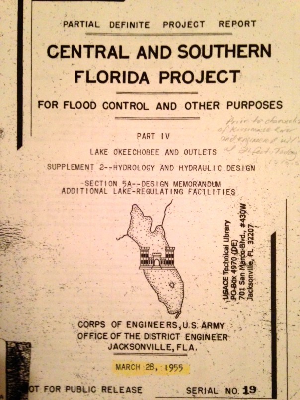
One of the first was the 1955 ACOE Central and Southern Florida Project Part IV. It was a proposal evaluating different options (plans) for “increasing lake outlet capacity. One component was “Plan 6,” a one mile wide floodway extending from the Herbert Hoover Dike to one mile into Water Conservation Area 3. For this report, Plan 6 was the recommended improvement. Dr Gary Goforth notes discharges to the St Lucie would have been lessened about by half, but “not eliminate lake discharges to the St Lucie River.” In the end, the entire plan was not acted upon as many tax payer paid plans are not…but Plan 6 was not forgotten…
Photos taken of 1955 ACOE CSFP Report courtesy of Dr Gary Goforth.Floodway 1955
Various references to Plan 6 and a floodway.
Dr Goforth also notes a “more robust plan,”a plan co-authored in 2009 by Karl Wickstrum, Paul Gray, Maggy Hurchalla, Tom Van Lent, Mark Oncavgne, Cynthia Interlandi, and Jennifer Nelson. (See first photo in this blog.) This plan is referenced by Mark Perry in his well known “River of Grass” presentation.
Mark Perry’s drawing in his presentation for “River of Grass,”used today, 2014.
The Art Marshal Foundation (Art was one of the great conservationist of the early 1960/70s environmental movement and has a wildlife preserve named after him) also notes in their literature that Plan 6 is traceable to the Marshall Plan-1981.
“Marshall Plan 1981 to Repair the Everglades, Why Plan 6 Will Work.” Marshall Foundation publication 2013, Version 2.2.
Most recently in 2013, the Rivers Coalition published on its website “Plan 6 Flowway, River of Grass, Missing Link.”
You can learn more about this version of the plan by clicking on the above link.
All of these plans, I believe, are one way or another based upon the 1955 ACOE Report. it may not have come to fruition but it certainly provided a lot of inspiration!
Also last year, Senator Joe Negron was able to secure $250,000 for a University of Florida study that should occur in 2014 for “Sending more water south.” Wonder what their plan will recommend?
If history repeats itself, even more Plan 6 versions will be created. In any case, let’s keep pushing for change to save the estuaries and find some way to move more water south. And thank you Army Corp of Engineers for the inspiration…
Aerial of the confluence of the SLR/IRL off of Sewall’s Point, June 27th, 2014. (Photo courtesy of Scott Kuhns.)
If there is one thing constant about the St Lucie River/Indian River Lagoon’s problems, it is that they are multi-layered and complex. I believe this is one reason it has been so hard to “fix.” If there were just one problem, it would be easier, but there is not one problem, there are many.
So, today I wanted to focus on C-44 basin runoff, again, as it has been in the news a lot, especially the two weeks since I was gone as I heard it really rained and we even got our first named hurricane.
The photo above shows the waters just off of the tip of Sewall’s Point on June 27th, 2014. Disgusting.
Basin map Martin/St Lucie SLR.
The basin map above reminds us of the C-44 basin’s location in southern Martin County. The “basin” is the large area surrounding the C-44 canal in black lines. As we know, this area is largely agricultural and was expanded over the years to drain more land than nature intended.
Through permits with the South Florida Water Management District the agricultural businesses are allowed to use water from the C-44 canal for irrigation when needed, especially during the “dry” season. The Army Corps of Engineers manages the level of the canal mostly for agricultural use; this is an historic relationship. In spite of “best management practices” much of the water used to irrigate their fields, runs back into the canal, over and over again, filled with fertilizers, pesticides, herbicides, etc…This is the untreated, polluted water that goes straight into our rivers.
As we can see looking at the canal map, over the years, the C-44 basin has become tremendous in size in order to drain land for agriculture and development. Millions of gallons of water come off these lands when it rains, as has been the case the past couple of weeks.
This recent photo below by local river activist and fishing guide, Michael Conner, shows what the C-44 basin water looks like when it comes out of the S-80 gates at St Lucie Locks and Dam, the same gates that are used when water is released from Lake Okeechobee when the ACOE opens S-308 at the lake. This can be confusing because usually we associate this type of photo with releases from Lake Okeechobee. S-80 can release just C-44 canal water or “just lake water,” or both lake and C-44 water…
Releases from S-80 from the C-44 canal at St Lucie Locks and Dam, July 2014. (Photo courtesy of Michael Connor.)
So why haven’t we talked about the C-44 basin until this summer, or seen or very much about it in the newspaper “before?”
Well, it is confusing to the lay person, and I don’t claim to know everything, but I will explain what I can.
Generally, in the past, the ACOE did not usually release the C-44 into the river during the summer…but this summer they are. Why?
Well according the the “Environmental Impact Statement (EIS) for the 2008 Lake Okeechobee Regulation Schedule (LORS),” the document the ACOE uses to manage Lake Okeechobee:
“All alternatives assume back flow from the St Lucie Canal, C-44, to Lake Okeechobee to be allowed to occur at lake stages of 14.50 ft or 0.25 from the bottom of the the lowest non-baseflow regulatory zone, whichever is lower.”
Basically this means that under most circumstances if the lake is under 14.5 feet, which it is now, (13.38), the ACOE will “back flow” C-44 canal runoff water into the lake through S-308, rather than sending it east to the SLR/IRL through S-80. This summer the ACOE has chosen not to do this, so we are getting C-44 basin water released into the SLR/IRL so the water looks gross. In the ACOE’s July 11th, 2014, public periodic scientist call email statement, explaining their choices, it reads:
“The Water Control Plan deliberately allow some flexibility to consider real time and forecasted conditions and decisions made within the guidance provided by the Water Control Plan…for the specific decision not to flow water from the C-44 basin into Lake Okechobee since 12 June 2014, the conditions that we took into consideration were rising lake levels, water supply, remaining duration of the wet season and proximity to the low sub band….the 8 July report from the South Florida Water Management District evaluates the condition of St Lucie Estuary and states “salinity at US1 is within the preferred range for oysters in the mid estuary.”
Photo of SLR/IRL off Sewall’s Point yesterday, 7-15-14. (Thank you Ed Lippisch)
Hmmm? Obviously the SFWMD’s salinity report was not that of Mark Perry’s at Florida Oceanographic…Let’s read and take a look.
Mark Perry feels the ACOE should be back flowing the C-44 water into the lake. He says:
“According to the Water Control Plan for the Lake the Corps should be opening S-308 and back flowing this local basin runoff into the lake when the lake is below 14 feet and the C-44 is above 14.5 feet but they have chosen to make steady releases from the C-44 basin through S-80 into the St Lucie at near 1000 cfs since June 14. Not so good outlook for the St Lucie Oysters…”
Please view his chart below that shows what has happened to salinity levels since the C-44 has been flowing into the SLR/IRL. (Mind you C-23, and C-24 are also dumping their basin runoff water, but C-44’s basin area is larger.)
Salinity is going below safe levels for oysters since the C-44 basin at S-80 has been opened.
On the other hand, friend of Mark Perry, Kevin Henderson, long time advocate for the SLR/IRL and founding member of the St Lucie River Initiative, feels the ACOE is perhaps trying a strategy that will help the St Lucie in the “future.” Kevin states:
“I firmly disagree that the Corps should always run C-44 drainage west until the Lake reaches 14.5. That is the pattern that gets us the most continuous lake and C-44 drainage into the fall, and the the patten that kills oysters…It is not basin runoff that kills the estuary, it’s months of continuous discharges at rates that never let salinity recover. This is why I advocate sending C-44 drainage west only when local salinity could recover for a while, then send it east again and do not let Lake O get high enough to wreck us with longer term discharges…”
I think he’s saying, the ACOE, by not consistantly filling the lake up with C-44 basin water during summer, may be avoiding long term runoff into the SRL/ILR in the future come fall…
Hmmm?
Both Mark and Kevin have a point.
My non-scientific perspective?
I think the ACOE was so taken aback by the wrath of the general public last year, the River Warriors, the River Kidz, the River Movement, the Stuart News/media, as well as some politicians, that they will do “almost anything” not to release water from Lake Okeechobee into the St Lucie River/Indian River Lagoon if they don’t have to.
By letting the C-44 basin water go into the river and not the lake, if a hurricane comes, there is just that much more room in the lake to hold the water so they don’t have to dump here and listen to us scream….
Mosquitos were a great nuisance to early Florida pioneers, often swarming by the thousands. Mosquito impoundments created to control their breeding have destroyed over 40,000 acres of important salt marsh habitat along the IRL. (Public internet photo, 2014.)
So there Ed and I were, in San Francisco, for my 50th birthday, and although we had a fantastic trip, everything I looked at that had to do with water, I saw through my “Indian River Lagoon” muck colored sunglasses…
Photos: Water quality sign San Francisco Bay; restored tidal marsh at Chrissy Field; map showing former natural tidal marsh area of San Francisco Bay compared to today.” (Photos Thurlow-Lippisch, 2014.)
On our first day, we decided to rent bicycles and ride over the Golden Gate Bridge as my sister Jenny and her husband Mike had recently done the same. It was great fun, and once I got my legs moving, we first explored a nearby area that is being restored and redeveloped around Chrissy Air Field.
There were educational signs discussing the importance of salt marsh habitat and a map showing how much marsh had been lost in the development of the San Francisco Bay area. The main focus was on the “restored” marsh in front of us that had been a dump for the military and filled in with sediment from the bottom of the bay.
From the 1800s through around 1960 marshes were considered “unhealthy.” But in time it was realized that marshes contributed greatly to environmental health and were critical for good water quality, wildlife habitat, and linked to clean drinking water.
Reading the signs I said to Ed: “Wow! Look Ed, see that NOTICE sign for the bay’s water quality and bacteria levels.? Just like home!” Ed smirked, more interested in the old airfield that still took up a good portion of Chrissy Marsh.
So we rode our bikes over the Golden Gate Bridge and as I was struggling to breathe and not collide with on coming bicyclists, I thought about salt marshes in my own home town, and how they were destroyed not by a dump, filled in to become an air field, but mostly by mosquito impoundments.
Ed and my bicycle ride over the Golden Gate Bridge, 2014.
Before and after the turn of the 19th century, Florida was full of mosquitos and even in the 1960s when I was living in Stuart, they were ferocious. I remember being at the bus stop in in middle school and running in place the entire time so they couldn’t bite my legs. There were positives as well, like the social event of riding my bike with my friends behind the mosquito truck with its billowing cloud of pesticide spray that came to visit every few evenings during the summer. 🙂
Today it is well accepted in scientific circles that the most extensive impacts of Florida’s salt marshes have been associated with mosquito control programs which continue to be in great demand in Florida today. Some of the highest densities of mosquitoes ever recorded in the continental US occurred right here in south Florida before mosquito control.
To alleviate this issue and encourage development in Florida, salt marsh impoundments were constructed as a government management technique to decrease mosquito populations by continually flooding impounded areas of marsh. Around 1930, thousands acres of wetland marshes along the Indian River Lagoon were flooded to keep misquotes from hatching as salt marsh mosquitoes lay their eggs just above the edge of the water level in these areas. By flooding the impounded marshes, mosquito managers could flood the impoundments and drown the eggs.
Today there are 192 impoundments along Florida’s east coast. A large percentage of these impoundments are in IRL as the IRL takes up 40 % of Florida’s east coast. These impoundments are separated from the lagoon by dikes built around a designated area so it can be filled with water via a pump systems. Over 40,000 acres…
Filling these areas with water has had a huge ramifications on wildlife in the lagoon as the dikes cut off juvenile fish and other critters from their needed protective mangrove/seagrass areas and habitat. Over time, this habit disconnect and loss has led to the extinction the dusky seaside sparrow in the 1987 and much lower and less healthy fish populations.
Also, in some cases the impoundments did not work, or were not well managed, and became breeding grounds for mosquitoes. Drowned native vegetation suffered, especially noticeable is the loss of the giant black mangroves, whose breathing, tubular root systems were drowned killing these ancient trees and leaving them as sentinels of death within the system.
Things have gotten better. As the destruction of salt marshlands and the negative effects on the IRL became more apparent, in the 1980s and 90s some mosquito managers started altering their practices by managing chosen sites with the RIM or “Rotational Impoundment Management Plan.” The RIM program is a seasonal rather than yearly control method, promotes flushing of impounded areas, uses fewer pesticides, focuses on water quality improvements and the promotes restoration of native vegetation.
These improved management strategies have helped lessen the isolation of fish species from their habitat; have allotted benefits to animals, trees, and vegetation; and improved water quality for tiny and important marsh critters, the base of the food chain. Nonetheless, the “tidal exchanges” of the impoundments are limited and not what nature intended.
While fighting for the IRL, we must remember to fight on all fronts and continued improvements of mosquito impoundments should not be forgotten!
So in conclusion, I loved visiting California. There were too many people but great beautiful, protected National Parks.
I am really enjoying being home, especially in my own bed. And right away, on the first night back, I had a wildlife visitor welcoming me home, the familiar sound in the darkness of a mosquito buzzing around my ear!
Fresh water releases from basin runoff through local canals C-23, C-24, and C-44 as well as polluted fresh water from releases from Lake Okeechobee through C-44, cover near shore reefs off of Stuart and Jupiter Island. (Photo MC archives, 2011.)
The concept that fresh water is a “pollutant” is sometimes confusing as we typically associate pollution with heavy metals, nutrients like phosphorus and nitrogen from fertilizer, and muck accumulation, on the bottom of the river, from sediments running off of lands, through canals. Believe it or not, too much fresh water is just as polluting and has dire consequences for the St Lucie River/Indian River Lagoon.
This is historically ironic as well, as when the Ais Indians lived in this area, the St Lucie River was a large fresh water “stream.” Throughout history, most of the time, the “St Lucie,” was not connected to the ocean. The natural inlet at what was later called “Gilbert’s Bar” by the Spanish was sometimes open, sometimes not, but never for too long, and the inlet opening was much smaller and shallower than today’s St Lucie Inlet.
Yes, we are going back, before we go forward, but history is important to know!
The “St Lucie Inlet” was permanently opened by hand using shovels, in 1892, by local pioneers who wanted access to the ocean for trade and communication. They had no idea that by doing this they would create “the most bio-diverse estuary in North America.”
As the salt water came in and mixed with the fresh water of the St Lucie and the “fresher than today’s water” of the Indian River Lagoon, one ecosystem, a freshwater ecosystem was destroyed by the salt, and another was born.
Over time, more fish and critters entered the St Lucie/ Southern Indian River Lagoon than at any other time in known history. The forks of the St Lucie, north and especially north, remained more “fresh” as the salt water usually did not go up that high into those areas. Perfect! Salt and fresh water fishing! It was a unique situation and as mentioned in the day before yesterday’s blog, presidents and other famous people swarmed to the St Lucie for its amazing fishing during this era, and all enjoyed.
Then things changed. In the late 1920s and early 30s, due to flooding of agricultural lands and bad hurricanes killing people living and working in the southern area surrounding the lake, the Army Corp built the C-44 canal from Lake Okeechobee to the south fork of the St Lucie River. Then in the 50s and 60s they built canals C-23 and C-24 as part of the Central and South Florida Flood System, another “flood protection project.” Although all of these drainage programs helped agriculture, especially the sugar industry south of the lake, and citrus, in mostly St Lucie and parts of Okeechobee counties, as well as greedy developers, it did not help the St Lucie River. In fact, these drainage canals have been slowly killing the St Lucie and Indian River Lagoon ever since.
How?
Through many things, but believe it or not, mostly through fresh water.
Once the estuary (St Lucie/IRL) became brackish, a mixture of fresh and salt water, this delicate balance was important to the fish, mammals and others critters that made the river/lagoon their home in this new found paradise.
Briefly, I will summarize some of the killer effects of fresh water on its residents:
1. Fish: When there is too much fresh water the fish get lesions. This is from a fungus that only can live and operate in a fresh environment. The name of the fungus is Aphanomycesinvadans and its spores get into fish skin when temperatures are low and water is fresh causing horrible lesions. More lesions have been reported over time in the St Lucie River that any other site in Florida according to the FDEP report at the end of this blog. The worst outbreak was in 1998 after the ACOE had been releasing fresh water from Lake Okeechobee in the winter months due to heavy rains. Thousands of fisherman were reporting fish with lesions; it is well accepted in the literature of our state agencies that this outbreak was connected to the gigantic releases of fresh water from Lake O.
Striped mullet with lesions. St Lucie River, 1998. (Photo, DEP State of Florida.)
2. Bottle nosed dolphins: Dr Gregory Bossert formerly, of Harbor Branch, has done extensive research into lobo-mycosis, an awful skin disease, in dolphins of the SLR/IRL. The highest number of dolphins with lobo in the entire 156 mile Indian River Lagoon system from Jupiter to New Smyrna Beach, are in the Stuart to Sebastian area. Dr Bossert’s 2009-20014 “Application for a Scientific Research Permit” to NOAA states on page 59:
“Water quality in the central and southern segments of the lagoon, is influenced by infusion of water from flood control drainage canals, e.g., in particular, run-off form agricultural watersheds and fresh water releases from Lake Okeechobee. (Sime, 2005.) Discharges from these sources introduce higher amounts of nutrients, metals, pesticides and suspended solids into the system (Woodward-Clyde, 1994). Analysis of spatial distribution of presumptive cases showed that the highs rates occurred in the IRL segments 3 and 4 confirming our earlier observations.” (Mazzoil, 2003/Rief, 2006).”
(Sections 3 and 4 are the “south central” and “south” IRL/SLR-from-south of Sebastian Inlet, to Stuart’s St Lucie Inlet. IRL dolphins are “site specific” staying usually in a 30 mile range. The St Lucie River is considered part of the southern IRL.)
S. Indian River Lagoon Dolphin with lobo mycosis. (Photo Dr Gregory Bossert.)
3. Seagrasses: Seagrasses are the basis of health for the entire SRL/IRL. Seagrasses that live in an “estuary” need sunlight and brackish (part salt/part fresh) water to survive. among other problems, the fresh water releases cause turbidity in the water so the grasses can’t get light and they die. Mark Perry of Florida Oceanographic states that during the Lake Okeechobee and canal releases from 2013, that lasted five months, up to 85 percent of the seagrasses died around the St Lucie Inlet. All nursery fishes are affected by this and of course it goes right up the food chain. Manatees, an endangered species, that live exclusively off of seagrasses, are very affected and reduced to eating drift algae that in some cases kills them. Dolphins are swimming around saying: “Where are the fish?!”
Unhealthy looking seagrasses coated in algae as seen 6-14 near St Lucie Inlet at low tide. (Aerial photo, Jacqui Thurlow-Lippisch)
4. Near shore reefs: The reef system in our area is the northern most of a tropical reef system that goes all the way south to the Keys. It cannot survive with fresh water dumping sediment on its delicate system and altering the salinity of the St Lucie Inlet. Insaine. These reefs are supposedly “protected.”
Freshwater pollution and near shore reef, St Lucie Inlet. (MC archives, 2011.)
I could go on and on, but I will stop here. I’m sure you get the point. Salinity is a delicate and important part of a healthy estuary. Generally short lived fresh water releases during heavy rains by our local canals are bad enough, but long term dumping of Lake Okeechobee releases on top of that, is certain death. It must stop. Send the water south.
_______________________________________________
(NOTE: The links below were removed by the Florida Department of Environmental Protection in 2016. When I called and asked why, I was told they were archiving…JTL)
The S-80 structure at St Lucie Locks and Dam. C-44 canal in background goes miles to Lake Okeechobee where the S-308 structure is located at the eastern edge of Lake O. (Photo Scott Kuhns, 2013)Drainage basins into the St Lucie River, note C-44 south. (SFWMD, 1999.)
The locks are back in the news again. WPTV, “hard working for the river reporter,” Jana Eschbach, broke the story yesterday, that the Army Corp of Engineers did not alert the public that they would be releasing polluted canal, C-44 basin water through the S-80 structure into the St Lucie River. Jana, like most people, feels that the public should be alerted when polluted water will be coming into the estuary in that we swim and fish. She is also concerned the water in the area of Palm City and the Roosevelt Bridge, which has been reported to have high levels of bacteria, will be pushed to the popular Sandbar area.
This can be confusing. Don’t we just care about lake water? Also, if the locks are open, doesn’t that mean the ACOE is releasing Lake Okeechobee water? Not necessarily, and the basin water can be just as damaging to the estuary and the public. So how does releasing basin or lake water work?
There are two structures along the C-44 canal which runs along the side of Highway 76 from the South Fork of the St Lucie River, to Lake Okeechobee: S-308 at the edge of Lake Okeechobee, and S-80, 20 miles or so, east, at the St Lucie Locks and Dam.
This ACOE canal and structure map shows S-308 at Lake O. and S-80 along the C-44 inland.
S-80 serves duel purposes. First to release water through Lake Okeechobee, but only if S-308, at the lake, is open first, allowing water into the C-44 canal. Then S-80 lets the water pour into the St Lucie River.
Second, S-80 can be opened just to allow water from the C-44 to flow into the St Lucie River, as the C-44 canal is surrounded by a 185 square mile basin, mostly agriculture, that has been directed to flow into the canal when it rains. Agriculture also uses this water in the C-44 canal to water their crops. To make things more confusing, C-44 can “deliver” local basin runoff in both directions: to Lake Okeechobee and to the St Lucie Estuary. The ACOE decides where the water “needs” to go by opening and closing the structures of S-308 and S-80.
It must be noted that the water from the C-44 basin is polluted, as is the water from Lake Okeechobee. The Florida Department of Environmental Protection writes: “…the construction of the C-44 canal has had the greatest impact of the St Lucie Estuary–and nearly all of that impact has been bad, FDEP 2001.) The charts below show how much nitrogen and phosphorus come into the river from the C-44 and other basins. C-44 is the highest. Phosphorus and nitrogen mostly from fertilizer, feed toxic algae blooms in the hot summer months.
Similar charts shows amounts of nitrogen and phosphorus runoff into the SLR. Note C-44 basin is the highest. (SFWMD, 1995.)
Fortunately, there is good news due to the help of our local, state and federal governments. The almost 3 billion dollar “C-44 Storm Water Treatment Area/Reservoir” has received first stage fundings and is under construction in Indiantown. It has been since 2011. This reservoir will hold the release water from the C-44 basin and clean it before it is returned to the St Lucie River. This is a huge positive, although it will not stop the releases from Lake Okeechobee.
An educated public is the best defense against the continued destruction of the St Lucie River/Indian River Lagoon. Thank you for being part of the solution and hopefully, next time, the ACOE opens any structure for any reason, they will alert the public, because here in Martin and St Lucie counties, we want to know!
I taught middle and high school for many years, and I still have numerous friends in the profession. Last week, I received a phone call from teacher, Maureen Breslauer, whose son now attends Bessey Creek Elementary School in Palm City. She asked if I’d like to be filmed by the school’s media specialist, Kelly Middleton, creating a River Kidz public service announcement, as the school, headed by outstanding, Principal Defenthaler, has been learning about river issues and were having a T-shirt day. I was grateful to Maureen for the opportunity to share the concept of “River Kidz” through the morning news. The product reminded me of who I am “most,” at heart, a teacher, and very funny in that in “a moment,” I became the “River Lady.” We did it in one take! For any you who watched MrRoger’s Neighborhood growing up, I think you’ll get a kick out of the video.
*River Kidz, a division of the Rivers Coalition: (
“End of the Rainbow,” South Florida. (Photo by John Whiticar, 2013.)
As we approach hurricane season, we must prepare for rain. Florida is more like Africa than the rest of the county in that there are really only two seasons: dry and rainy. “Officially,” rainy season runs from June 1st to November 30th, and dry season is from December 1st through the end of May.
One of the most interesting accounts I’ve ever read of a “great south Florida rain” was published in 1886 by pioneer Charles Pierce, member the famous Hannibal Pierce family, to which our illustrious Indian Riverkeeper, Mr Marty Baum belongs. We along the St Lucie/Indian River Lagoon are part of the south Florida great rain system and there are reoccurring themes whether here or farther south, as l think you’ll see as I share the story.
Charles Pierce is most well known for his book “Pioneer Life in Southeast Florida” written about the years 1870 through 1894, and published by Miami’s University Press in 1970. It is a five star classic. According to a write up on the book, during this era of Florida history around 724 people were living between Stuart and Miami.
My mother, historian Sandra Thurlow, shared an excerpt that Charles Pierce wrote for the Broward Legacy in 1886, as he was living and overseeing the Biscayne House of Refuge at the time.
According to Pierce:
“In October of 1884 occurred the greatest and longest rainfall ever known on the east coast since its earliest settlement. It poured down for eight days and nights, slacking at times for a few minutes, but never stoping; then came down harder if that were possible. The whole southern part of the state was inundated…
On the eighth day the rain stopped and the next day came in bright and clear, and the sun shone brightly on a rain-soaked Florida…
I was on the east porch looking out to sea…looking up the coast to the northward, I caught the glint of something white about four miles away. At first, I thought it was a sea gull, then it looked like striking fish. I was not certain which it was, so I went for the old long spyglass to get a close up view of the scintillating white. What the spyglass revealed surprised me. The flickering white I had seen was now clearly shown to be whitecaps or breaking seas at the head of a dark body of water rushing down the coast….a mass of dark water some hundred feet in width rushing along to the south and with breaking seas over running the blue water in front.
It was a strange sight and at first we all wondered where it came from. My father Hannibal solved they mystery when he said, ‘It is fresh water from the New River Inlet.’ Could that be possible? It was fourteen miles away but there was no other solution to the phenomenon.
What a mighty volume of water must be coming out of the inlet and with tremendous velocity enough to overcome the resistance of wind and sea for so many miles. By night of that day the entire ocean in sight of the Station was covered with dark coffee-colored freshwater from the New River. Not a bit of blue water to be seen in any direction. Biscayne Bay was fresh for nearly a month after the week of rain.”
Incredible. So even before humankind diked and channelized the entirety of south Florida, when it rained heavily, the black wave of fresh water pushed forth through the south eastern inlets to the ocean; it did not just “go south.” We see a similar but not as intense phenomenon today, although drainage has been modified, when a heavy rain gushes through the St Lucie Inlet, Ft Pierce or Jupiter Inlets. In any case, when one hears a story such as Mr Pierce’s it makes one wonder, with all that water, during a really “great rain” a rain that comes only once in a few hundred years, will our manmade structures hold?
We all know the Army Corp of Engineers, along with support from the South Florida Water Management District, is working diligently to harden the dike around Lake Okeechobee, but it seems that a third outlet, a flow way south, from the lake to the Everglades surely would alleviate some of that natural pressure, the pressure Charlie Pierce describes as a
“tremendous velocity…”
If he were alive today, I wonder what Mr Charles Pierce would think?
Army Corp of Engineers’ structure S-80 releases water from Lake Okeechobee into the the C-44 Canal that leads to the St Lucie River/S. Indian River Lagoon. (Photo Jacqui Thurlow-Lippisch, 2013.)
Today is what I consider the genesis of the Martin and St Lucie River movement, as last year, on this day, May 8th, 2013, the Army Corp of Engineers opened the gates of S-80 once again, but little did they know, this time things would never be the same….
Before we laud ourselves too much it is important to know our history and its not a fun one to study. Martin County and the C-44 Canal have a long history, in fact the canal, started in 1915 precedes Martin becoming a county which occurred in 1925. The City of Stuart though was incorporated in 1914, and it was their early leaders that supported the the building the C-44 canal.
Ironically most the early settlers wanted it, having no idea of its unintended consequences, and in 1915 even held a celebration when construction began by featuring the high school band and a gathering at Woodmen Hall in downtown Stuart.
According to historian Sandra Thurlow’s book Stuart on the St Lucie:
“The Stuart Times pleaded for a canal in its early issues in 1913. The Stuart Commercial Club pushed for the canal and clashed with BW Mulford and and other promoters of Salerno who insisted that the best route for the proposed ship and drainage canal from Lake Okeechobee would be one cut into the Manatee Pocket.”
The canal was an economic issue and people wanted jobs and trade brought to the area.
After the Hurricane of 1928 the canal was widened and deepened, and the situation really got worse. “Silt and chemicals entered the St Lucie/Indian River and diminished the once teeming fish population.” Again according to Sandra Thurlow, “because the the changes were gradual it took a while to notice that the abundance that had nourished the settlers and attracted the sports fishermen no longer existed.”
Hard to believe isn’t it? I have had some people tell me, “It’s better not to bring this up….” I disagree. Times change and values change. Our country is known for overcoming some of the most difficult of institutions such as slavery and women’s rights. Environmentalism is also a social issue. It is based on how one views the world, what is acceptable or not.
Today most Stuart and Martin/StLucie residents agree that it is no longer acceptable to have up to 9000 cubic feet per second of dirty, tainted Lake Okeechobee water released into our St Lucie River. In 2013 the releases from Lake Okeechobee tipped the scale for toxic algae blooms in the estuary, (FOS, Mark Perry). And it was well known from sampling that the South Florida Water Management District (SFWMD) knew toxic algae was being released into the estuary at S-80.
In the early 1900 and even through the 1970s, not that many many people lived in Martin County. Having grown up here, I can attest to that. But, that is not the case today. Releases that were simply “accepted” are now “unacceptable.” Unlike years ago, with today’s high population and health and safety issues that are the responsibility of the state, the releasing of toxic waters from outside our basin is an embarrassment and seems illegal.
1930 was the first year the Martin County Commission asked the ACOE to stop discharging and passionate people have been demanding such ever since. But at that time, there were not enough people to really have a voice and the general public was not screaming along side its leaders. Today we are are all on one page. Local elected officials and the public. And we also have tools that allow us to make our cause a state and national issue.
If history has shown anything at all it is that things do change. I believe we are the generation that is in the right place at the right time to finally cause the turn of history for the St Lucie River/Indian River Lagoon. Happy May 8th, 2014!
A portion of the restored Kissimmee River. Note discolored and filled C-38 canal juxtaposed to winding restored, greener oxbows. (Photo Jacqui Thurlow-Lippisch, 2014).
Last week, on a hazy smoked filled afternoon, Ed and I flew over Lake Okeechobee and the once mighty Kissimmee River. There was the normal stress involved with me giving Ed directions and the fun of an adventure. It went something like this:
“Oh there it is, the Kissimmee’s opening to the lake, over there!”
I can’t fly north of “over there,” it’s off limits; it’s a near a bombing range or air force base…” says Ed, shooting me a serious glance.
“What a bombing range-air force base? You’re kidding, close to of some of the state’s richest wildlife habitat? How symbolic…”
Ed rolls his eyes, I can feel it. But he tries harder…
Somehow, Ed talks to Miami Air Traffic Conrol and we get lucky. It is a Sunday and we are allowed to fly over at least part of the area I wish to see.
On the way, we fly over the southwest area of the lake’s agricultural lands. The hand of humankind is reflected in organized, perfect sized boxes of agriculture and straight canals.
We veer off to the northwestern area of the Lake Okeechobee where earth and water meet; on this side of the lake the hand of the Creator still evident. Little specks of light blend together in a blinding symphony of light.
We near the area in Okeechobee County where the mouth of the once great Kissimmee meets Lake Okeechobee. The straightened canal looks out of place among the lush greenery and a small town is evident. There are people here. Flooding is an issue.
It is great seeing “it all” from above as I have never really been able to figure out on a map where the Kissimmee River restoration is happening. It starts about 20 miles north of the lake.
The Kissimmee river was once 103 miles of wildlife/fish filled meandering oxbows, but it was canalized to a depth of 30 feet as C-38 from 1962-71. This was part of the Army Corp of Engineers and the Central and South Florida “Flood Control Project” of 1954. The state had asked for help after two back to back hurricanes and wide spread flooding and destruction in 1945. The state got help but with untended consequences…
The Kissimmee River that once meandered south to Lake Okeechobee as part of a two mile wide flood plane now shot down to the lake with grave environmental effects that included the destruction of the estuaries, St Lucie/Indian River Lagoon and Caloosahatechee.
Since 1994, around 23 miles of the now 56 mile long canal, C-38, from Lake Kissimmee to Lake Okeechobee has been/is being backfilled and considered part of “the” most ambitious environmental restoration project in the world.
Recently, the ACOE and SFWMD have been in a dispute over the completion of the restoration project. The project is tremendously expensive requiring federal and state funding which has not come easy since 2008. The two agencies “cost share” in its completion. Word is they are “working things out…”
The long term goal is to continue the restoration of at least 20 miles more of the 56 miles of the canal.
In light of the dying Indian River Lagoon, it is important to see that restoration can be accomplished. Mother Nature is quick to rebound once given the chance.
The Kissimmee’s restoration is critical, as the polluted waters coming from Orlando south carry sediment, and urban and agricultural runoff into the lake. As we know, when the lake gets too full the water is diverted to the estuaries because the water is not presently allowed to flow south, as the EAA (Everglades Agricultural Area) is located there along with cities of people.
So we here along the St Lucie Indian River Lagoon, are fighting a two front war. One north and the other south of the lake. We are winning in the north because the ACOE and SFWMD recognized their/our mistakes, and have been working since 1994. We are also getting closer in the to finding a safe way to “move the water south…” CEPP (Central Everglades Planning Project) is not looking good right now, but the pressure is on, and even Tallahassee is saying “move the water south!”
We must have inspiration or we will never complete our goal of saving the estuaries. The Kissimmee River is a place to look and find hope.
2014 Google Earth map of restored area of Kissimmee River.
Topographical map of EAA showing elevations. CEPP would move approximately 15% of Lake Okeechobee’s overflow water south and build a basis for future increases, rather than sending all water through the northern estuaries. By means of canals in the EAA and other structures, this water would be cleaned and then directed to the Everglades. The ACOE refused to sign off on CEPP 4/22/14. (Map courtesy of INTER-MAP via Kevin Henderson)
CEPP=Central Everglades Planning Project, 2014,( contains elements of CERP); CERP=Comprehensive Everglades Restoration Plan of 2000.
To every action, there is a reaction, and in the case of the ACOE refusing to sign off on CEPP, the reaction here in Martin, St Lucie, and Lee County across the state certainly will not be “good.”
Mind you there is a Jacksonville ACOE, who works with “us” and then the ACOE in DC. They are the same but different…
Let’s start at somewhat of the beginning so we can get a grip on this always terribly confusing, multi-layered attempt to fix our estuaries and restore the Everglades.
Around 2000, long before I was involved with the River Movement directly, a group of Florida stakeholders, including environmentalists, the agriculture industry, tribes, utilities, users, and government agencies miraculously agreed on something called CERP, or the Comprehensive Everglades Restoration Plan. This plan consisted of at least 68 projects to “fix the Everglades.” It was historical and celebrated by all. Congress approved and eventually appropriated some funds that would be shared in costs with the South Florida Water Management District, (SFWMD) towards “CERP.”
Now, 14 years later, some work has been done, but not one of the 68 projects has been completed.
OK now we move to 2010, 2011… still in the sinkhole of 2008 Great Recession, the SFWMD, the local ACOE Jacksonville team, and the stakeholders decide sitting with “nothing” is not an option and determine to do something unprecedented and “speed things up.” They work like crazy, often being criticized by those same stakeholders, to package some of the CERP ideas into CEPP (the Central Everglades Planning Project) to sell to the DC ACOE and Congress again, in a different form, and get things going.
Although often behind, the Jacksonville ACOE appears to almost meet their deadline of 18 months and finally, two weeks ago the SFWMD is able to sign off on cost sharing (not an easy task and not all supported the move) on the local Jacksonville ACOE completed CEPP project— which of course has to meet every Tom, Dick and Harry regulation you can possibly imagine. A neurotic situation for sure.
So yesterday, Earth Day, the Washington D.C. ACOE office refuses to sign off on CEPP, saying they need more time to review the documents they have had since last August.
As of yet, no official statement has been given, but the local press and the Everglades Foundation’s Eric Eichenberg call the move “a staggering failure of duty and responsibility.” I would imagine the main concern here is that the Water Resources Development Bill (WRDA) that only comes around once every 5-7 years these days, must include CEPP for it to be funded (appropriated) by Congress. Now it seems CEPP will certainly not make the deadline, which is really “now.”
So is there hope? We all know, that “it’s not over until its over,” and until the WRDA is officially closed, perhaps some political miracle could ensue. Is it likely? I would doubt it. But I do not know.
What I do know is that Florida has been really dependent on the Federal Government since 1933 when the Florida Legislature and the people of Florida convinced the US Government to build the Herbert Hoover Dike around Lake Okeechobee and the ensuing flood control projects over the years to protect the important growing agriculture industry south of the lake and thousands of people who were allowed to build and develop inside the Everglades’ historical flow area, especially south from Palm Beach to Dade counties. At this time there was no thought of the estuaries.
So in many ways we want our cake and to eat it too….”protect us from the waters of Lake O but don’t hurt the estuaries….” Something is going to have to give.
For almost four years, Senator Joe Negron has been pushing for less involvement of the ACOE. Whether one likes Senator Negron or not, I agree with his philosophy. Congress/ the US ACOE is no longer supporting the dredging of our state inlets which they did for almost 100 years, and they most likely not going to support the restoration of the Everglades and the betterment of the estuaries through changing our pluming system and sending more water south. After 14 years of of begging, and celebrating crumbs, you’d think we’d get the message.
Is this the Jacksonville local ACOE’s fault? Not really as the Federal Government is simply terribly dysfunctional so it is hard for the ACOE to do its job, plus they are broke.
In conclusion, yes, we have to finish what’s been started, and I recognize the difficulty of “us” fixing our own problems, however; if we really take a hard look in the mirror, there may not be a choice but to try.
S-80 connecting Lake Okeechobee to the St Lucie Canal or C-44 controlled by the ACOE. (Photo JTL)
“Who controls the past controls the future. Who controls the present controls the past.” George Orwell
I used to think it was the Colonel of the Army Corp of Engineers who single handedly had control to open the gates at S-80 and S-308 to allow the waters of Lake Okeechobee to flow into the St Lucie River, Indian River Lagoon. (http://www.saj.usace.army.mil/Missions/CivilWorks/LakeOkeechobee.aspx)
But since February of last year, I have gotten more insight.
As an elected official, I am allowed to sit in on the Army Corp of Engineers “Periodic Scientists Call” that occurs about once every two weeks. Last year I was invited to sit in with Martin County and I have attend ever since.
No experience has helped me understand the south Florida water process as much as consistently sitting in on these calls.
The call is a meeting of the scientific stakeholders to give their input to the ACOE before the Corp makes its “guidance” for Lake Okeechobee, and usually the following Thursday, after, meeting with the SFWMD, a “recommendation.”
As you can imagine, the call is run by the US Army, so it is very systematic and the language is filled with acronyms and science jargon. For the first six months, I was basically a silent idiot listening to a foreign language. But slowly I have been catching on.
Thankfully some things are totally predicable. For instance, every call the first thing that is accomplished after reading the rules of the call, is that the roll call is taken. I like to listen to who is there: ACOE? Florida Fish and Wildlife Commission? City of Sanibel? Ft Meyers? Martin County? St Lucie County? NOAA? Florida Dept. of Environmental Protection? Florida Department of Agriculture and Consumer Services? SFWMD? Broward County? Highlands County? Osceola County? Tribal Nations? Lee County? Ding Darling? Congressmen and other elected representatives? Members of the public? Other?
Next, each stakeholder, one at a time, gives an update on their specialty and makes their case for their interest. Public members are then allowed to speak and and the again the ACOE leader goes through everyone one more time to see if if anyone has new comments based on the other just shared.
The calls are scientific and unemotional. However, there times of tension and difficulty like last year when the ACOE began releasing to the St Lucie River, Indian River Lagoon and Caloosahatchee on May 8th and continued steadily, then intensely, through September 21, 2013. This tension may start up again soon, as the lake is higher than they wish for this time of year and it has been a wet winter. The “decision” should become public today.
I have to say that after sitting in on all these calls, the Army Corp often holds back when the LORS chart, and maybe even the SFWMD, says to “release.” But in the end, the inevitable occurs.
Although I appreciative of the hard working men and women who run the ACOE, I do think the overall system fails to take into account the long term survival needs of the natural system which includes “us,” and favors the security of resources of the sugar industry and agriculture south of the lake. It is easy to fall back on “flood control” each time the lake rises, and dump east and west, but the system is more far reaching and has greater demands than just that. The water they are dumping, 1.7 billion gallons on average a day, is simply wasted due to an outdated system. (FOS, Mark Perry)
On a deeper level, the intertwined culture of the SFWMD, the ACOE and agriculture, especially the sugar industry, is one going back over 100 years. Their connection runs deep and is a cultural one, one that has allowed them to control water and politics for their own interests in South Florida, past and present.
But times change and world views evolve. Personally, I am pushing for a future a little less Orwellian, and a little more respectful, of our natural resources and Mother Nature.
Historical marker of mass burial site for Florida’s 1928 hurricane, near Port Mayaca, Indiantown. (Photo by Evie Flaugh)
If you drive west from Stuart, on Highway 76 towards Port Mayaca, you’ll eventually see a large graveyard on the left hand side of the road. It is well kept and reminiscent of an old Florida, a Florida of pioneers, the Klu Klux Clan, and the Indian Wars. Large oak trees line the property and the unusually massive grave stones stand like sentinels to a time long past.
At the entrance is a memorial sign dedicated to the approximately 3000 people who were killed in the Florida hurricane of 1928. An earthen dike, barely holding back the waters that had naturally flowed south for thousands of years, breeched, killing mostly black agricultural migrant workers, while flooding sugar, vegetable farms, and personal property built in the path of the natural flow way south of the lake. Thousands of bodies were laboriously buried in mass graves, one in Martin and another in Palm Beach County. (http://www.srh.noaa.gov/mfl/okeechobee)
African American, Etonville writer, Zora Neale Hurston, http://en.wikipedia.org/wiki/Zora_Neale_Hurston) writes in her classic novel, Their Eyes were Watching God, about migrant workers “looking back” as they were running to escape the furry of the 1928 hurricane.
“Above all the drive of the wind and the water…and the lake. Under its multiplied roar could be heard the almighty sound of grinding rock and timber and a wail….people trying to run in raging waters and screaming…The monstropolous beast had left his bed. The two hundred miles an hour winds has looses his chains. The sea was walking the earth, with a heavy heel.”
All work for blacks during the late 1920s was difficult and filled with the prejudice and hardship of the Jim Crow Laws. In the sugar industry there were complaints of “controlling” black harvest labor, aided by law enforcement, debt peonage, forced labor and even killings.
Today when people speak about the hurricane of 1928, the death of the workers south of the lake is credited as the source for pushing for “flood protection.” This is not full disclosure.
The truth of the matter is that the storm was also an opportunity for the struggling sugar industry, south of Lake Okeechobee, not only to “protect” their poorly treated laborers, but to rally local, state and national government officials to support legislation to “invest” in the area against future flooding for the benefit of their fields, and the future riches of the industry. (Source Raining Cain in the Glades, Hollister, http://www.press.uchicago.edu/ucp/books/book/chicago/R/bo5704198.html)
This was no easy feat and insanely expensive in a time around the U.S. Great Depression. Politicians and businessmen were creative and put emphasis the Okeechobee Waterway for “navigation, “rather than focusing solely on “flood protection.” At the time, navigation funds were much easier to get from the federal government than funds for “drainage” or flood control of the newly created Okeechobee Flood District.
These funds came to fruition in the construction of the “Cross State Canal,” also known as the “Okeechobee Waterway, “which links the Caloosahatchee River to Lake Okeechobee, to the St Lucie River and Indian River Lagoon and conveniently doubles as a giant drainage canal for the sugar industry, diverting as much a 92% of the flow of water south of Lake Okeechobee.
You may have seen an arch in Rio that says “Gateway to the Atlantic.” That arch was built in celebration of he Cross State Canal…
Local people at the time had no of idea the greater repercussions of such to their greatest local resource, the St Lucie River, Indian River Lagoon. We still sit open mouthed today when S-308 at Port Mayaca is opened by the Army Corp of Engineers, and our area’s river resources are destroyed. Certainly we have our own local canal and runoff problems, but Lake Okeechobee’s tremendous waters, all the way from Orlando, are most destructive.
It’s exhausting. The Cross State Canal was completed in 1937, and we in Martin County have been fighting ever since, the changing winds of Florida’s hurricane of 1928.
In the late 1960s, one of the best things about Christmas, was that old Christmas trees reinforced our fort under the old oak tree, we pretended was a ship, along the St Lucie River. I remember going to my neighbors, the Schramm’s house, with all their brothers and sisters, to have cinnamon sugar toast for breakfast around this time of year.
Mrs Schramm’s cinnamon toast was like nothing I had ever had: butter, sugar and cinnamon on Wonder Bread toast. Delicious! Little did I know, that one day I would be criticizing the sugar industry for not doing enough to help us save the Indian River Lagoon.
The book is credited as the first “to study the environmental transformation of the Everglades within the economic and historical geography of global sugar production and trade.” It is an “environmental history,” a discipline that is becoming more studied and written about: how we as humans effect change in our environment.
The book’s history is amazing and so far the story that has hit me the most is one about Mr Bohr Dahlberg who in the late 1920s owned Southern Sugar Company before it went into “receivership” and was purchased by Stewart Mott who created the United States Sugar Corporation. http://www.ussugar.com/downloads/ussc-history.pdf
Although Mr Dahlberg’s company went broke by 1928, the year of the great hurricane, he managed to break the Democratic hold on the “South” and form relationships with Republicans across the country for the benefit of the sugar industry in South Florida by supporting the successful presidential campaign of Herbert Hoover. Mr Hoover was a man who came to the support of those who had supported him, and it is he who authorized the building of the Herbert Hoover Dike around Lake Okeechobee, to protect the sugar industry’s lands and the labor. The dike was completed in 1933 and changed forever the fate of the Everglades, the St Lucie River, and the Caloosahatchee River.
The politics of this book will make your jaw drop. Expressions such as: structure of the world system, national and global importance for presidents, national interest and world unrest, supposed and real issues of national security, using drainage and navigation to nationally fund the Okeechobee Flood District, the Army Corp of Engineers, the Cross State Canal that opened up the major draining of Lake Okeechobee into the St Lucie River/Indian River Lagoon.
All of this happened thirty years before I ate that cinnamon toast at the Schramms; there are fifty more years of politics that have come into play since then! The whole thing is rather daunting, but whether a kid, or a 50 year old today, I think the Sugar Industry owes the St Lucie River/Indian River Lagoon something, after all we take their drainage and I ate all that toast as a kid.
Change on the Map “Seat of War, 1839,” East of Lake Okeechobee
I use my mother a lot when I speak about myself because she has had such a profound impact on me. She and my father taught me to like maps, to like history, to like the stories of the people of today and of those that were pioneers, in our once great wilderness. And my mother, unlike me, is much more accepting of our area’s change. “It’s history,” she says….
I look at this 1839 map excerpt, I see so many changes, and I wonder if the history we are creating is going awry. This 1839 map was a war map because we were at war with the Seminoles pushing them further into the interior of the Everglades. They never surrendered….but we took most of the lands they lived on and changed them.
In 1892 we dug, by hand, the St Lucie Inlet, once Gilbert’s Bar, that had closed up since this map was drawn, creating the most bio diverse estuary in North America, as salt water and fresh water of the ocean, and St Lucie River/ Indian River Lagoon, mixed; in 1923 we dug the C-44 canal from Lake Okeechobee to the St Lucie River as an outlet for a “diked” lake that had been created for agriculture south of the lake, the first and “most important” industry in our state; in the 1930s and 40s we built C-23 and C-24 to drain the “useless” Alpatiokee Swamp meandering through “Martin and St Lucie Counties,” once known as “Mosquito County;” we “moved” the Indian River Inlet, creating the Ft Pierce Inlet; we built bridges, houses, roads, schools, churches and other places of worship, and finally we built shopping malls. We fought wars, had children, we had grandchildren, farmed, started businesses, went through desegregation and women’s rights. And along the way we loved and cherished what we had created, although it was hard: “a human paradise,” a veritable Garden of Eden.
And what do we have today? For me, it is still paradise, with a couple of caveats, a dying river, children who can’t swim or catch fish with out the possibility of a tumor or lesion, a lot of people on the road…. Can we turn back? Or is this change going to be constant? I think even my mother would say: “the river’s history, is a history to change.”
Sheepshead with tumor from North Fork of St Lucie River caught 2-8-14 by Dave Smith
This photo showed up on the Rivers Coalition facebook page yesterday. The fisherman reported catching the sheepshead near the mouth of Bessey Creek, close to the hugely polluting C-23 canal. Within minutes, the photo had been shared 30 times and numerous comments ensued.
Unfortunately, tumors and lesions are not new or unique to our time. In fact, the Rivers Coalition formed in 1998 when the locks were opened from Lake Okeechobee to a level rarely experienced. So many fish had lesions that the cover of the Rivers Coalition handout included the photos below.
As usual the government did a “study” to determine the “possible” causes: SLR/IRL fish lesion studies and the study did state “water quality” was the cause—polluted water from Lake Okeechobee; C-23; C-24 and others local runoff. Years of destruction to fish habitat.
Today,we seem to be making progress as people, as voters, but policy makers and politicians continue to ask for more studies, more science. I completely respect science, and yes, science changes over time, however; you don’t have to be a scientist to “know/see” there is a problem and have the common sense just to fix it.
One of the greatest things about the river movement that started in the summer of 2013 is that young people are involved. This video entitled “Estuary’s Story” is by local and FIT student, Allison Randolph. She aims to educate and inspire. This video will complete nationally for young directors. Kudos to Allison and all the young people who are speaking out for their and the river’s future. Please click on link: “An Estuary’s Story” above.
The St Lucie & Caloosahatchee estuaries drained Lake Okeechobee for agricultural lands south of the lake, 1920s.
Before the land was altered, a sixty mile wide, winding, shallow, grassy, river, meandered south of Lake Okeechobee feeding the Everglades. The powers of the time were determined to drain these lands since the mid 1800s and by 1920 they had; a remarkable feat. And as many of the great “accomplishments” of the past century, this feat, not only achieved its goal, but also led to massive environmental destruction. Progress went too far. It is now the mission and economic opportunity for upcoming generations to undo damage done. The only true way to accomplish this is to create a third outlet south of the lake as the amount of water needing to go south in rainy times could never possibly be fixed by well intended “projects” north or around the lake…