Tag Archives: C-44

The Long Deteriorating “Fishing Ground of Presidents,” St Lucie River/Indian River Lagoon

Harold R Johns, posing with a large tarpon, early 19920s, Stuart, St Lucie River. (Photo from Stuart on the St Lucie by Sandra Henderson Thurlow.)
Harold R. Johns, posing with a large tarpon, early 1920s, Stuart, Florida, St Lucie River. (Photo from Stuart on the St Lucie by Sandra Henderson Thurlow.)

When the pioneers permanently opened the St Lucie Inlet in 1892, it killed the freshwater grasses that filled the waterways creating a brackish estuary that due to the convergence of tropical and temperate zones, and the nearby warmth of the Gulf Stream, became “the most diverse estuary in North America.” (Gilmore)

After a short period of time, sportfishing thrived in the area, and fishing guides called Stuart the “fishing grounds of presidents” as US president, Grover Cleveland, vacationed and fished the area in 1900 and years after.

In spite of long standing issues with the health of the estuary,  as late as the 1970/80s Dr Grant Gilmore of Harbor Branch documented over 800 species of fish living and breeding in the then healthy seagrasses around Sailfish and Sewall’s Point at the convergence of the St Lucie River and Indian River Lagoon. This was a larger variety of species in one place than any other area in United States. (Gilmore)

"Goliath Grouper" called "Jew Fish" at the time, Stuart. ca. 1920s. (Thurlow Collection)

“Goliath Grouper” called “Jew Fish” at the time, Stuart. ca. 1920s. (Thurlow Collection)

Going back to the the 1930s, the 1938 Blue Book, a popular annual fishing publication of the time, lauds fishing throughout the entire Stuart area:

“The City of Stuart located approximately 20 miles south of Fort Pierce is world renowned for its fishing. Located as it is…it offers a variety of fishing similar to Fort Pierce but somewhat more pronounced, particularly with regards to the tarpon, sea trout, snook, channel bass, bluefish, crevasse jack, pompano and ladyfish. It’s fresh water fishing is particularly good far into the back county among the Sloughs with their tributary and drainage canals to Lake Okeechobee and the many drainage canals through this territory. These Sloughs and Canals offer splendid fishing for black bass, as well as for the larger game fish from the salt water, such as  th snook and tarpon, that make their way into Stuart Harbor and on up into the both and south branches of the St Lucie River. –Particularly good fishing for these species can be had at the St Lucie Locks about 12 miles inland south of Stuart…”

All photos from Stuart on the St Lucie, Sportfishing chapter, by Sandra Henderson Thurlow.

IMG_5769 IMG_5767

It is interesting to note that although the Blue Book piece, written in 1938, celebrates Stuart’s fishing, one can find evidence of tension regarding the releases from Lake Okeechobee in the literature of the day as early as 1925.

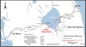
Fearing the onslaught of development in the booming twenties and the changes brought on by the connection and building of the C-44 canal from Lake Okeechobee to the South Fork of the St Lucie River, beginning in 1923, the South Florida Developer’s, November 10th, 1925 headline reads:

Article 1925, South Florida Developer. (Thurlow collection.)

“Fish Will Leave the River As City Grows, Fisherman Assert, Sewage and Oil Sure Death to a Favored Sport is Verdict.”

The article quotes commercial fishermen who know that  the over abundance of fresh water from Lake Okeechobee will chase away the salt water fish and that the oil on the water from development, perhaps from cars and road runoff,  if excessive, won’t allow the fish to sufficiently breathe.

Fishing guide Phil O’Brian is quoted as saying: “I know the ways of the sea fish. They can’t stand fresh water; and they won’t stand sewer water. We have the fresh water now mixin’ in from Lake Okeechobee and we’ll soon have the sewer water.”

These pioneers are probably rolling over in their graves should they have learned about the story of the St Lucie/Indian River Lagoon most recently.

The St Lucie River was labeled “impaired” by the Florida Department of Environmental Protection in 2002 mostly due to pesticides and heavy metals from agriculture and urban pollution runoff accumulating in the sediment from all area canals, especially C-44 and Lake Okeechobee. In a way, just like the 1920s fisherman foresaw…

The fight against the area canals and Lake Okeechobee continues today, and if by the grace of God we can undo some of the hands of history, the St Lucie and Indian River Lagoon will surely heal herself and we once again could be the ” Fishing Grounds of Presidents…”

…but then we might have to get rid of that green and sprawling golf course at the Floridian.

______________________________________________________

FDEP Impairment St Lucie River: (http://www.dep.state.fl.us/southeast/ecosum/ecosums/SLE_Impairment_Narrative_ver_3.7.pdf) 

What Did It Look Like Before the ACOE Built the C-44 Canal along the St Lucie River?

The South Fork of the St Lucie River prior to the construction of the C-44 canal. (Photo ca. 1920,  courtesy archives of Sandra Henderson Thurlow.)
The South Fork of the St Lucie River prior to the construction of the C-44 canal and nearby orange grove. Today, this area is Four Rivers subdivision in Palm City.  (Photo ca. 1920, courtesy archives of Sandra Henderson Thurlow.)

For many years, I was searching for old photos and maps showing what the river looked like before it was intersected by the C-44 canal, at the south fork of the St Lucie River, in Martin County around 1923. The canal was widened and deepened many times thereafter, but according to documents, the construction began around that time.

I felt like a sign should be erected noting the spot were we changed the St Lucie River/Indian River Lagoon forever….I still have not done this, even after the spot was discovered.

Time went on, and one day my mother, historian, Sandy Thurlow, looking through her old aerial photos said, “Jacqui, I think I found it! That spot you are looking for.”

C-44 construction linking canal to south fork of St Lucie River, early 1920s. (Photos from archives of Sandra Henderson Thurlow.)

These are the aerial photos she sent me. I wanted to share. I will not write much today, as a picture speaks a thousand words….

_______________________________________________________

FDEP/History C-44 Canal: (http://www.dep.state.fl.us/southeast/ecosum/ecosums/C-44%20Canal%20.pdf)

FDEP-Evidence of Impairment, C-44 Canal: (http://www.dep.state.fl.us/southeast/ecosum/ecosums/C-44_Impairment.pdf)

Understanding Appropriations for the IRL & Okeechobee Basin, Fiscal Year 2014-2015

Florida League of Cities, 2014. (Photo FLC/Negron)

Senator Joe Negron, Senate Appropriations Chair, and leader of the “Senate Hearing on the Indian River Lagoon and Lake Okeechobee,” brought home more money for the IRL compared to any other water body in the state: $231,998,021. Our springs comrades  who have been publicly fighting ten years longer than us, brought home 30 million. Tallahassee is wondering who this new kid on the block is, us….

Appropriations chart IRL/L.O. Basin 2014/15. (Senator Negron's  Office)
Appropriations chart IRL/L.O. Basin 2014/15. (Senator Negron’s Office)

Whether you are a fan or not, it must be noted that Senator Negron stuck his neck out, possibly compromising his senate presidency, to get our “name on the map” as far as Tallahassee  goes. Prior to last year, most “good ‘ol boys in Tallahassee would have said, “Indian River Lagoon…Hmmmm? Creature of the Indian Lagoon, ain’t that a movie?”

Nonetheless, I do not pretend to think that these monies alone will cure the lagoon’s ills, as the gorilla in the room has not been addressed “head on and in its entirety:” the releases from Lake Okeechobee through S-308 and S-80. I believe this will come in time if we keep fighting.

In my opinion, the biggest part of change is the first step. With the outrage of the public over the “Lost Summer’s” toxic St Lucie River and Indian River Lagoon, and the support of Senator Negron, one of the few  people in a the legislature with the seniority and status to act somewhat independently of demanding party pressures to conform, we have taken the first step forward to fixing the lagoon. Actually, a leap.

WE MUST CONTINUE, YES! But let’s be happy that we have made public progress on a state level more than ever before, and let’s look at what we received, as we should be aware of the gift of public monies from people all over our great state and be full of gratitude. 

It’s a lot to go over, but it is important, so I will simply go down the list and summarize. Let’s look at the map as well. Please remember the SLR/IRL is part of the greater Everglades system, from the Kissimmee River area in Orlando, south to the Tamiami Trail in Dade, and beyond to Florida Bay.  So anything done to help “the system,” helps us move water south, and with our health as well.

Fascility and Infrastructure Location Map Index, 2014. (Senator Negron's Office)
IRL/L.O. Fascility and Infrastructure Location Map Index, 2014. (Senator Negron’s Office)
Key to star/locations on map.
Key to stars/locations on map.

Here we go!

1. $32,000,000 for Water Quality storage in Storm Water Treatment Area 1 in Palm Beach County. Water storage is key to stop releasing so much into the estuaries.

2. $3,000,000 for Best Management Practices (BMPs) for farmers in the St Lucie, Lake O, and Caloosahatee watersheds. It is difficult to swallow more public money going to help farmers with pollution runoff, but there is no other way to do this. We must continue to help fund them, big or small. This is a historical issue as they have been here since the 1800s in many cases. I look at it like “grandfathering” with an extra requirement, as in real estate. The good news is that as time goes on, agriculture businesses will have higher standards to avoid pollution fertilizer, pesticides and fungicide runoff that is killing our waterbodies. Hopefully we can make changes before the rivers and springs die off completely.

3. $40,000,00  for the C-44 Storm Water Treatment Area/reservoir in Martin County. This will offset local drainage farm and urban runoff along the C-44 canal, not water from Lake Okeechobee. We must clean our local runoff as well as it is responsible for around 50% of the destruction to our estuary and on an everyday basis.

4. $2,000,000 CERP Picayune Strand east of Naples in Collier County. This area is important to the southern glades and needs monitoring and vegetative management for water flow and storage and improvement. Hopefully it will help some panthers too!

5. $5,000,000 C-111 South Dade. This is a crucial water delivery system to allow more water to “go south.” A  must.

6. $5,000,000 Kissimmee River Restoration. The all time worst thing ever done in Florida other than dike Lake O and redirect the water to the estuaries, was to straighten the Kissimmee River. (Hold my tongue!) Restoration of the ox bows must continue. So far the ACOE has restored about 22 miles of the 56 miles of what was once 153 miles of gorgeous serpentine like, vegetative, wildlife filled, cleansing waters.

7. $18,000,000 C-43 STA along Caloosahatchee River. This is the equivalent of C-44 STA/reservoir for the Caloosahatchee.  Only fair. C-43 is a must. They take up to three times the polluted runoff from Lake Okeechobee that we do!

8. $20,000,000 IRL muck removal in northern lagoon. The northern IRL has lost 60% of their seagrasses and has 2 Unexplained Mortality Events including manatee, dolphin, and pelican die offs. Give them what they need! Sediment/muck fills the lagoon over the years from canal runoff covering seagrasses; when stirred up, it releases legacy pollution. GET THE MUCK OUT!

9. $2,075,000 Lake Worth Lagoon. Lake Worth does not get the attention it needs being in development happy Palm Beach County. This area was once full of sea grass and life but not after years of receiving dump water from Lake O, like us, but through a different canal. Local advocate, Lee  Shepard, is a great advocate for this part of the lagoon. Let’s help!

10. $4,000,000 Water Quality research for  Harbor Branch and ORCA. Although it is hard to justify “more tests,” as we can all see the lagoon is dying, these new, scientific studies will help us find sources to our pollution issues that the legislature can’t ignore.  Septic leakage,  especially, is difficult to trace without such systems. LOBOS and Kilroys, please help us!

11. $1,000,000 Oyster recovery programs for St Lucie and Caloosahatchee Rivers. Millions of dollars worth of  oysters, natural and deployed by government programs, died during the fresh water discharges of 2013 and years before. One oyster can filter 50 gallons of water a day. Government in action….

12. $90,000,000 NUMBER ONE NECESSITY  is raising the Tamiami Trail in Dade County so water is not blocked off from going south. They should raise the whole  road as the road built in the 1920s cuts off the flow of water south to the Everglades  for the entire state. (Another environmental nightmare to fix.)

13, $2,7769,585 This money will be used for pump improvements etc to move more water south and cut away vegetation blocking water “going south,” or hold water in the C-43/44 reservoirs that would go into the estuaries.

14. $2,076,728 The Loxahatchee is one of two “Wild & Scenic Rivers” in the state of Florida and home to tremendous amounts of wildlife. Helping with storm water runoff and preservation is key for the health of this important part of the Everglades System.

15. $2,076,718 The St Lucie Rivers Issues Team has a long history of working with local governments for “close to home” projects along the SLR/IRL. Kathy LaMartina at its helm, South Florida Water Management District. Thank you!

Grand total= $231,998,021

I am  grateful to the state legislature, especially Senator Negron, and I must note Governor Scott did not veto one line. But please know everyone, the “fight for right” along the Indian River Lagoon has just begun!


Florida Inland Navigation District, F.I.N.D., Maintaining the Okeechobee/Atlantic Waterways of the St Lucie River/Indian River Lagoon

The Okeechobee Waterway or Cross State Canal is managed through a partnership of  F.I.N.D.and the US government.
Parts of the Okeechobee Waterway or Cross State Canal, (partially C-44), is managed through a partnership of F.I.N.D.and the U.S. government, ACOE. (Photo Jacqui Thurlow-Lippisch, 2009.)

The Intracoastal and Okeechobee Waterways are important navigation channels and part of our country’s heritage.

Atlantic Intercoastal Waterway from Maine to South Floida. (Map, public.)
Atlantic Intracoastal Waterway from Maine to South Floida. (Map, public.)


Okeechobee Waterway from Atlantic to Gulf of Mexico. (Map, public)

The history of navigation in the United States is a long one that is difficult to put into perspective within the context of today’s modern world. Military, commercial and communication centers were imperative goals to the newly established United States and remain so today, but these things are now taken for granted and have also inadvertently caused massive environmental destruction.

The Atlantic Intracoastal Waterway is a 3000 mile inland waterway along the east coast of the US from Maine to Florida. The Okeechobee Waterway is a few hundred miles across the state, from Stuart to Ft Meyers, linking the Atlantic to the Gulf of Mexico through canals and Lake Okeechobee.

These canals are directly supported by the public though a tax.  If you look at your tax bill you will notice you are charged a .3045 mill to maintain the Florida Atlantic and Okeechobee Intracoastal Waterways. After a long evolution, today, the state’s Florida Inland Navigational District or FIND is the entity that acts in cooperation with the US Government, Army Corp of Engineers,  to oversee these tax funds in order to maintain these important canals that serve many purposes.  Some we don’t like…

One of the purposes of the Okeechobee Canal, built in the late 1920s and “improved” many times since, by being deepened and widened,  is to release water from Lake Okeechobee into the St Lucie River/Indian River Lagoon when Lake Okeechobee gets too full, as the lake  has been diked for the safety of agricultural lands and urban communities living around and south of the lake.

The mission of FIND is very broad actually; if we look at the mission statement of FIND it reads:

“The Florida Inland Navigation District has two primary missions: (1) to perform the functions of the “local sponsor” of the Atlantic Intracoastal Waterway project and a portion of the Okeechobee Waterway project in Florida, both of which are State/Federal navigation projects, and (2) provide assistance to other governments to develop waterway access and improvement projects. As the local sponsor of the Waterway, the District provides all lands required for the navigation project including rights of way and lands for the management of dredged materials removed from the waterway channel during dredging activities.”(http://aicw.org/index.jsp)

FIND is overseen by commissioners from the twelve counties along Florida’s east coast. Commissioners are appointed by the Governor and approved by the Senate. Our local commissioner is friendly and well known,  Mr Don Cuozzo.

Don Cuozzo
Don Cuozzo

FIND also serves other purposes very close to the people and local communities that I do care about, such as providing grant funding for local waterways improvements, and maintaining the important manatee signage and protection zones. We all know this iconic and endanger species, a gentle, distant relative of the elephant, is often stuck by speeding boaters.

Award winning photo seen in National Geographic story on south Florida waters.
Award winning photo seen in National Geographic story on south Florida waters, 2012.) (Photo by Paul Niklin, friend of Nichole Mader.)

Thank you to FIND, but it sure would be nice if we could FIND another way to for the lake’s water to go than through the St Lucie/Indian River Lagoon.

For 2013, Ed and I paid $13.31 to FIND. Although I would prefer not to support the Okeechobee Waterway atrocity, I do like manatees, boating, and the Town of Sewall’s Point has benefited from FIND grant programs as well.  So, I guess, for now, Ed and I  will pay the tax; but one day, I have the feeling, I might just rebel!

_______________________________________________________

Atlantic Intercoastal Waterway (http://en.wikipedia.org/wiki/Atlantic_Intracoastal_Waterway) 

Okeechobee Waterway, ACOE: (http://www.saj.usace.army.mil/Missions/CivilWorks/LakeOkeechobee/OkeechobeeWaterway(OWW).aspx )

The “River Lady’s Neighborhood” along the the Indian River Lagoon


I taught middle and high school for many years, and I still have numerous friends in the profession. Last week, I received a phone call from teacher, Maureen Breslauer, whose son now attends Bessey Creek Elementary School in Palm City. She asked if I’d like to be filmed by the school’s media specialist, Kelly Middleton, creating  a River Kidz public service announcement, as the school, headed by outstanding, Principal Defenthaler, has been learning about river issues and were having a T-shirt day. I was grateful to Maureen for the opportunity to share the concept of “River Kidz” through the morning news. The product reminded me of who I am “most,” at heart, a teacher, and very funny in that in “a moment,” I became the “River Lady.” We did it in one take! For any you who watched Mr Roger’s Neighborhood growing up, I think you’ll get a kick out of the video.

*River Kidz, a division of the Rivers Coalition: (

Home

) See River Kidz tab.


May 8th, 2013, the Day Things Changed for the St Lucie River/Indian River Lagoon

Army Corp of Engineer Structure S-80 releases water from Lake Okeechobee in the the C-44 Canal that leads to the St Lucie River.
Army Corp of Engineers’ structure S-80 releases water from Lake Okeechobee into the the C-44 Canal that leads to the St Lucie River/S. Indian River Lagoon. (Photo Jacqui Thurlow-Lippisch, 2013.)

Today is what I consider the genesis of the Martin and St Lucie River movement, as last year, on this day, May 8th, 2013, the Army Corp of Engineers opened the gates of S-80 once again, but little did they know, this time things would never be the same….

Before we laud ourselves too much it is important to know our history and its not a fun one to study. Martin County and the C-44 Canal have a long history, in fact the canal, started in 1915 precedes Martin becoming a county which occurred in 1925. The City of Stuart though was incorporated in 1914, and it was their early leaders that supported the the building the C-44 canal.

Ironically most the early settlers wanted it, having no idea of its unintended consequences, and in 1915 even held  a celebration when construction began by featuring the high school band and a gathering at Woodmen Hall in downtown Stuart.

According to historian Sandra Thurlow’s book Stuart on the St Lucie:

“The Stuart Times pleaded for a canal in its early issues in 1913. The Stuart Commercial Club pushed for the canal and clashed with BW Mulford and and other promoters of Salerno who insisted that the best route for the proposed ship and drainage canal from Lake Okeechobee would be one cut into the Manatee Pocket.”

The canal was an economic issue and people wanted jobs and trade brought to the area.

After the Hurricane of 1928 the canal was widened and deepened, and the situation really got worse. “Silt and chemicals entered the St Lucie/Indian River and diminished the once teeming fish population.” Again according to Sandra Thurlow,  “because the the changes were gradual it took a while to notice that the abundance that had nourished the settlers and attracted the sports fishermen no longer existed.”

Hard to believe isn’t it? I have had some people tell me, “It’s better not to bring this up….” I disagree. Times change and values change. Our country is known for overcoming some of the most difficult of institutions such as slavery and women’s rights. Environmentalism is also a social issue. It is based on how one views the world, what is acceptable or not.

Today most Stuart and Martin/StLucie residents agree that it is no longer acceptable to have up to 9000 cubic feet per second  of dirty, tainted Lake Okeechobee water released into our St Lucie River. In 2013 the releases from Lake Okeechobee tipped the scale for toxic algae blooms in the estuary, (FOS, Mark Perry). And it was well known from sampling that the South Florida Water Management District (SFWMD) knew toxic algae was being released into the estuary at S-80.

In the early 1900 and even through the 1970s, not that many many people lived in Martin County. Having grown up here, I can attest to that. But, that is not the case today. Releases that were  simply “accepted” are now “unacceptable.”  Unlike years ago, with today’s high population and health and safety issues that are the responsibility of the state, the releasing of toxic waters from outside our basin is an embarrassment and seems illegal.

1930 was the first year the Martin County Commission asked the ACOE to stop discharging and passionate  people have been demanding such ever since. But at that time, there were not enough people to really have a voice and the general public was not screaming along side its leaders.  Today we are  are all on one page. Local elected officials and the public. And we also have tools that allow us to make our cause a state and national issue.

photo

If history has shown anything at all it is that things do change. I believe we are the generation that is in the right place at the right time to finally cause the turn of history for the St Lucie River/Indian River Lagoon. Happy May 8th, 2014!

________________________________________________

DEP Eco-summary C-44 Canal: (http://www.dep.state.fl.us/southeast/ecosum/ecosums/C-44%20Canal%20.pdf)

Impairment of C-44 Canal, DEP: (http://www.dep.state.fl.us/southeast/ecosum/ecosums/C-44_Impairment.pdf)

The Coral Strand’s Fishing Riches; Today’s Sailfish Point, Along the Indian River Lagoon

1950 map by Ben McCoy of the "Coral Strand" and its riches,  today known as Sailfish Point.
1950s map of Hutchinson Island’s “Coral Strand.” Today, known as “Sailfish Point.” (Map, Ben McCoy, courtesy historic archives of Sandra Henderson Thurlow.)

How romantic, the “Coral Strand…” Like a string of pearls the riches of Hutchinson Island’s coast strung along the blue waters of the Atlantic and Indian River Lagoon. The crowing jewel, today,  known as Sailfish Point.

The above promotional map by Ben McCoy, brother, of the infamous rum runner, Captain Bill McCoy, highlights some of our area’s best features, most interesting history, and even an excerpt from a novel by Faith Baldwin:

” It was a long jut of land running into the water, upon one side was the ocean, upon the other, an inlet forming a small quiet bay. It was colored like a lithograph, strong blinding colors. The beach was so white that it dazzled, water and sky so blue they seemed unreal…”

If one looks closely at the map, fish of the area are listed around the point: Blue Fish; Sheepshead; Bass; Snapper; Pompano; Spanish Mackerel; and Tarpon everywhere…the Indian River is not noted just as the” Indian River” but the “Famous Indian River,” for fishing of course!

IMG_3626


The publication notes that five presidents, Arthur, Cleveland, Roosevelt, Taft, and Harding,  as well as Joe Jefferson, beloved  disciple of Izaak Walton, fished these waters as “who indeed among fisherman has not heard of the famous St Lucie Region, rendezvous for more than half a century for anglers  from all over the world!”

Believe it or not, according to The History of Martin County, the McCoy’s land, today’s Sailfish Point, was listed for $25,000.

It is fun to visit the dream like past, but soon or later, reality always sets in. In the 1950s the Coral Strand was sold to eccentric entrepreneur and Florida Oceanographic Society founder, James Rand, for its limited development the name was marketed as “Seminole Shores.” Later in the 1960s, the the Hutchinson Island property was sold by Harvard University to a group of Boston investors and eventually to Mobil Oil who legally tore the mangroves from the land, scared off the mosquitoes and filled it. Eventually, in the 80s the land was developed as exclusive “Sailfish Point.”

According to Dr Grant Gilmore, most famous for his long career at Harbor Branch Oceanographic, the waters/seagrasses surrounding Sailfish Point, the old Coral Strand, are truly the most diverse in the North America with over 800 types of fish, often growing baby fish, documented in these waters.

It is a crime that during rainy season, the Army Corp of Engineers often releases water from Lake Okeechobee exacerbating the pollution from our local canals killing the seagrasses in these waters, thus fish habitat destroyed. Last year, in 2013,  according to Mark Perry of Florida Oceanographic, approximately 85% of the seagrasses were destroyed.

Yes, this has happened many times, but one day, it may not come back.

For history, for today, we must fight to protect our “Coral Strand,” and our pearl, our incredibly bio-diverse waters…

___________

The History of Martin County can be purchased at the Historical Society of Martin County: (http://www.martincountyhistoricalsociety.com)


Lt. Governor, Carlos Lopez-Cantera and the Indian River Lagoon

14 year old Natalie and new Lt Governor, Carlos Lopez-Cantera

Last week, I took my fourteen year old niece, Natalie, to a meeting with me, to meet  Florida’s brand new, only seven weeks old in the position of Lieutenant Governor, Carlos Lopez-Cantera of Miami; he is the first hispanic ever to hold this office.

(http://en.wikipedia.org/wiki/Carlos_López-Cantera); (http://www.flgov.com/meet-lieutenant-governor-carlos-lopez-cantera/)

The purpose of the meeting was to “educate” the new lieutenant  governor about issues concerning the St Lucie River/Indian River Lagoon. I had Natalie for Spring Break and since she has  been a member of River Kidz (http://riverscoalition.org) since she was ten, I figured I’d put her to work.

I said, “Natalie, just be honest and polite. Shake his hand, look him in the eye, smile and then tell him how you and your family were affected by the releases from Lake Okeechobee and the other  canals last summer, the “Lost Summer.”

When it was our turn, Natalie went first. She did exactly what I had asked.  She shook his hand, looked him in the eye and smiled saying:” My name is Natalie and I live in North River Shores. Last summer, because of the releases from Lake Okeechobee, my family and I could not use the new wakeboard we got for Christmas, because the river was  off limits with toxic algae blooms.  Also we did not go fishing like we usually do. The water was gross…”

At this point, as there were others standing around listening and waiting to meet Mr Lopez-Cantez too,  I did my typical control-freak move and “nicely” butted in just to qualify a piece of information so my comrades couldn’t claim I was using Natalie for purposes of propaganda.

“Natalie, we should mention, that the other canals were releasing too; you know the C-23 and C-24; the C-23 is the one your sister did her Science Fair Project on…”

Natalie looked and me and the Lieutenant Governor looked at me. Natalie nodded her head, and Mr Lopez-Cantera honestly asked: “Don’t all the canals here connect to Lake Okeechobee?” Silence.

“I’m glad you asked, I  said. It’s all very confusing.” I drew a picture as Natalie explained that C-44 does connect to the lake, but C-23 and C-24 do not. She also explained that the C-23 and C-24 are very polluting canals, but it has been only when the heavy releases from Lake Okeechobee come, on top of the releases from our local canals, that the river goes completely toxic.

I told a story that is well known.  Prior to the releases from Lake Okeechobee, the South Florida Water Management District had taken samples of  toxic algae, “microcystis aeruginosa,”  a type of cyanobacteria,  from Lake Okeechobee at Port Mayaca , and the Army Corp of Engineers knew this,  before they opened the gates at  S-308 and S-80 allowing the water to flow into the St Lucie Canal and St Lucie River/Indian River Lagoon.

Images: (https://www.google.com/search?q=toxic+algae+st+lucie+river&client=safari&rls=en&tbm=isch&tbo=u&source=univ&sa=X&ei=tmA5U6yLIpTzrAGY7YGwDw&ved=0CHAQsAQ&biw=1598&bih=803)

I relayed that Mark Perry speaks on this situation often, reiterating again, that the river became toxic not while our own, although they be disgusting  canals, were releasing, but only when the massive water from the Lake Okeechobee was allowed in…

The Lieutenant Governor looked surprised, “Who is Mary Perry? ” he asked. “Mark Perry is the executive director for Florida Oceanographic,” I replied. Mr. Lopez-Cantera wrote down Mark’s name.

Our fifteen minutes were up, I gave the Lieutenant Governor  a booklet of  aerial photos my husband and I took of the river during the summer of 2013; he did a double take when he saw the cover but it was time to go.

Nonetheless,  he did not rush us off, and as we were getting up to go, he told Natalie about being a big wake boarder himself in Miami in younger days. We took a photo for Natalie’s album and then Natalie and I were off to walk the dogs and bake cookies since it was too windy to go to the beach.

I commend the Lieutenant Governor for coming to Stuart and meeting with local stakeholders to learn about the Indian River Lagoon, St Lucie River and Lake Okeechobee. I’m sure he has people pulling at him from all directions, but he came here.

As distasteful as politics is, at the end of the day, change for our rivers will come through the steady work of building relationships. By knowing our politicians, whether they be republican or democrat, the  face to face experience makes it harder for them to forget us when the vote is before them.

I’m hoping when it comes time for a vote, or in the future when the possibility of sending the water south is real, Lieutenant Governor Lopez-Cantera, or what ever his position is at that time, will remember the nice kid named Natalie from Stuart, and her story about not being able to wakeboard in  the toxic St Lucie River during the lost summer of 2013.


Aerials, “Never Forget the Lost Summer” St Lucie River/Indian River Lagoon

On September the releases were at their worst.
 Aerial photos of releases at St Lucie Inlet, Sewall’s Point and Jupiter Island at the height of releases from Lake Okeechobee. Area canals were also releasing at this time.  This era became known as the “Lost Summer, as waters were toxic for almost three months and visibly disgusting the two months before. The releases themselves began May 8th and stopped October 21, 2013. (Photos taken in August/September by Jacqui Thurlow-Lippsich and Ed Lippisch )

These shocking photos taken last summer have helped to keep up the pressure on Martin and St Lucie’s counties legislative delegation and others in both Tallahassee and Washington DC for change along water bodies releasing into the St Lucie River and Indian River Lagoon and future hope for future water storage and a flow way south.

Also, the Stuart News and Scripps Newspapers continues to post lagoon article almost every day. The business community, students, and retired, everyday people are still up in arms.

There are  both short and long term goals to save the Indian River Lagoon and St Lucie River, but the public’s collective memory is the greatest hope for a better future as we advocate, partake, and lobby for clean water.

As you go out this weekend and Spring Break begins for our area young people, recall last year’s late spring, summer and fall when the public  could not go out or into  our area waters.

And when you have a chance, call your local, state and federal officials and nicely ask: “How’s it coming with those  water issues,  and when are you up for reelection?”

IMG_8250 IMG_8254 IMG_8256 IMG_8259 IMG_8274IMG_3351 IMG_3361 IMG_7312 IMG_7314 IMG_7421 IMG_7435

Willoughby Creek/Canal Runoff, Stuart

Warner Creek and surrounding runoff into the St Lucie River Indian River Lagoon 2-2-14
Willoughby Creek’s surrounding runoff into St Lucie River/ Indian River Lagoon 2-2-14

Dark waters stained from deteriorating vegetation and full of sediment, phosphorus, fertilizer, pesticides, pet waste and other pollutants seep out into the the St Lucie River from Willoughby Creek in Stuart near St Lucie Boulvard and Indian Street.  After hard rains last week the runoff makes its way to the Indian River Lagoon and St Lucie River. Dirty waters are also rounding the corner here at Hell’s Gate, shown in this photo, from “up stream” at C-44,  C-23 and C-24 canals. This is basin water runoff, not from Lake Okeechobee. One notices the runoff more  as one approaches the St Lucie Inlet, as the incoming ocean waters are bluer and cleaner. During this photo, it was an incoming tide. Lake Okeechobee is not being released into the C-44 canal/SLR at this time. As you can see, even without Lake Okeechobee we are killing the river all by ourselves.  Nonetheless, the last thing we need is releases from Lake Okeechobee during the summer rainy season. Please be vocal to our local state and US delegation in letting  them know “clean water is business” in Florida.  We expect them to vote for policies in favor of the SLR/IRL. As  for ourselves, let’s start doing our own part by slowly removing  turf grass in our yards and replacing it with native and Florida Friendly plantings and thus stop throwing pollutants on our lawns as in the end, all water runs to the river…

Willoughby Creek runoff
Willoughby Creek runoff 2-2-14. Hell’s Gate and Sewall’s Point in view, Hutchinson Island and Ernie Lyon’s Bridge in the distance.