These photos are part of a series of “reservoirs” that have been covered in my blog the past months and is meant to be educational. The South Florida Water Management District is to be congratulated on completing the STA, a feat! However we must ask ourselves about the significance of the algae bloom as seen in a couple of the photos below.
There is a lot to this subject but for today, it’s just the photos!
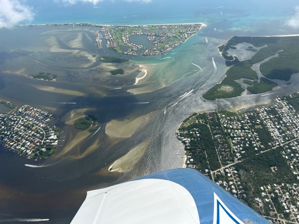
Geoffrey Smith and Ed Lippisch prepare for flight.EAA Reservoir/STA, 2-11-26. Ed Lippisch
Included are the ” STA 1-W, N side of Reservoir, Reservoir STA, and A-FEB.” Thanks SFWMD!
Partial view of the 10,000 acre C-43 Reservoir, 1/24/26, Ed Lippisch.
Today I am going to share all of the aerial photographs of the C-43 Reservoir that were recently taken by my husband Ed Lippisch. I think it is important to be able to “see” these huge CERP/Comprehensive Everglades Restoration Plan projects that are, or should be, coming on-line.
My post is meant to be a visual resource.
The C-43 Reservoir encompasses more than 10,000 acres and is located on the west coast near LaBelle, Florida. Ed took these photographs on January 24, 2026 and the reservoir appears to be empty of water, as it has not rained much and much of Florida has drought conditions.
What is the Interconnect or C-23 Estuary Discharge Diversion Canal? What does it look like?
Today I am sharing my husband Ed’s aerials of this new South Florida Water Management District built canal that is part of the Comprehensive Everglades Restoration Plan/Indian River Lagoon South project to help clean up the St. Lucie River. You may have seen it under construction when driving west on Highway 714?
Interconnect and C-23 canal
Interconnect and C-23 canal.
Northern Inflow Pump Station (S-457)
Another view C-23 canal and Interconnect
Interconnect Canal intersection with C-23 Canal
Interconnect Canal
Interconnect Canal
Interconnect Canal
Intake Canal C-44 Canal with C-44 Reservoir and STA
Interconnect Canal taken January 9, 2026 by Ed Lippisch.
“The C-23 Canal to C-44 Reservoir Interconnect Canal Project” as published by the South Florida Water Management District on 7-26-22 states that the project’s purpose is to remove excess water from the C-23 Canal to be diverted, via the Interconnect Canal, to the C-44 Reservoir and Storm Water Treatment Area and eventually cleaner to the C-44 Canal which leads to the St. Lucie River.
See north/south pink line connecting C-23 and C-44 Reservoir/STA.
~Project elements include a Northern Inflow Pump Station along the C-23 Canal (S-457)
~Culvert Crossings at CR 714 (S-458) and Coca Cola Road Areas (S-459S)
~Interconnect Canal’s official name is the (C-457)
~The North Segment (1) is three miles long; Middle Segment (2) is three miles long: and the South Segment (3) is one mile long.
~The Southern Fixed Weir Spillway and Service Bridge Structures is called (S-460)
Ed Lippisch’s aerial of the C23/24 STA looking east taken 1-6-26 in St. Lucie County. This STA will clean waters to the St. Lucie River from two reservoirs yet to be built. This STA is scheduled for completion by ACOE by end of 2026 but the reservoirs still need to be constructed.
Happy 2026! After a break the Florida Legislature is back in session and Everglades Restoration is back in the news. About a week ago, my husband Ed asked me what I wanted photographed for the new year, and I replied: “The C23/24 Strom Water Treatment Area in St. Lucie County.”
Ed came back after a morning of flight and said: “I can’t find it.”
“Hmmm, I thought. Maybe because it’s not full of water yet, it is hard to make out?”
After a little more study and pinpointing the entirety of the C23 and C24 Canals we found it! Because the reservoirs are not yet constructed there was little change to the look of the land. Thankfully storm water treatments areas “blend.”
So what “it”?
The C23/24 STA and Reservoirs are the northern part of Indian River Lagoon South. (IRLS) “Indian River Lagoon South” is the St. Lucie River’s portion of the Comprehensive Everglades Restoration Plan (CERP).
This is a very important part of the project and like the rest of Indian River Lagoon South has been a long time coming. And though Governor DeSantis did not mention it yesterday in his State of the State speech, it must be funded.
So where are things now?
Both the Army Corps and the South Florida Water Management District are responsible for completing the project.
Drew Bartlett, Executive Director of the South Florida Water Management District noted the following:
~C23/24 Strorm Water Treatment Area is under construction by the Army Corps of Engineers and should be finished in 2026. (above photo)
~C23/24 North Reservoir (to be built by the Federal/ACOE) is ready for construction, but not funded.
~C23/24 South Reservoir (to be built by the State/SFWMD) is ready for construction, but not funded.
~C25 Reservoir (State/SFWMD) is in design and will be ready for construction in 2027.
These giant projects are/have been a shared responsibility. The ACOE and the SFWMD are/have been a team…
Excerpt ACOE IRLS poster includes both Martin and St. Lucie counties. C23/24 is located just north of Highway 70 close to the St. Lucie County Fairgrounds. C25 is even further north and all majorly affect the St. Lucie watershed – once all connected to the famous Alpatiokee Swamp that cleaned and fed the beautiful St. Lucie River.
The Governor’s last budget request focused on fully funding the rest of the EAA Reservoir and CEPP, very important! But did not include a request for Indian River Lagoon South’s C23/24/25 components. If we’re going to finish the job for the St. Lucie River, “it” will need to be included too.
November 25, 2024 at 1:29 PM. This aerial shows the St. Luice already darkened and tainted by run off and discharges from C-23 and C-24 due to a season of heavy rains. On December 7th the ACOE and SFWMD approved Lake Okeechobee discharges to the St. Lucie for RECOVER part of LOSOM. RECOVER began only three months after the new lake schedule that was to provide relief to the estuaries began…(Photo Ed Lippish)
I feel inclined to write…even though I am focusing on the Palm City book my mother and I just launched, and even though my husband Ed and I still have 1000 miles to complete on America’s Great Loop. I think I can provide insight in simple terms to a very confusing water management system.
So you may have heard that on December 7th, the Army Corps of Engineers started discharging to the St. Lucie River again. Yes, our federal and State government is once again killing the St. Lucie River. The explanations in the past have been disturbingly simple. This time it is not.
In August of this year, 2024, after five years of struggle, the Army Corps finally adopted a new schedule for Lake Okeechobee. This new schedule, referred to as LOSOM, allows for more water to be held in the lake and thus fewer discharges to the St. Lucie River. Ironically from the onset of negotiations, even though the destruction of the estuaries by Lake Okeechobee had been the focus, many were complaining about the health of the lake as when the lake is kept higher for longer periods of time, submerged aquatic vegetation dies off causing a host of problems. Mind you, that in 2013, 2016, and 2018 the St. Luice was so damaged by discharges from Lake Okeechobee it literally became a toxic soup -with little remaining seagrass- and it has yet to really recover.
Anyway, LOSOM has something called RECOVER which means a water body is set to recover from all of its government caused destruction if certain conditions are met. Right now the conditions are in place to RECOVER Lake Okeechobee. So now, the St. Lucie will be damaged to benefit Lake Okeechobee as approved by the South Florida Water Management District and approved and executed by the Army Corps of Engineers.
It’s a delicate balance, destroy one water body and then the other just enough to keep it alive. Well I must say “thanks” for the three months “under LOSOM.” It was great!
And where is our once hero Governor DeSantis in all of this (Executive Order 19-12) I guess right now Politics trumps Water Management or does it?
My advice? Don’t look down although this is so depressing and like groundhog day. Look up and fight for right. Water is sacred. Let’s manage it as such.
Here is the press release from the Army Corps explaining their position in scientific detail:
From: “Levario, Jazika CIV CESAJ” <Jazika.Levario@usace.army.mil> Date: December 6, 2024 at 12:46:21 PM EST Subject:Lake Okeechobee Recovery Operations Begin December 7
Lake Okeechobee Recovery Operations Begin December 7
JACKSONVILLE, Fla. — U.S. Army Corps of Engineers (USACE) -Jacksonville District will begin releases under Lake Okeechobee Recovery Operations December 7.
For the past five years, Lake Okeechobee has experienced several storm events and extended moderately high lake stages. This has led to degraded ecological conditions within the lake, including significant loss of submerged aquatic vegetation (SAV), high turbidity and nutrient concentrations, and negative changes in emergent vegetation.
There are six considerations for implementing Recovery Operations – lake stage not receding below 13 feet in summer, SAV coverage significantly below 11,000 acres, no strong El Nino, nor strong La Niña forecasted for the dry season, lake stage not receding below 11 feet NGVD in the last five years, ecological and Snail Kite conditions, and no water supply concerns. Each of these six of the considerations have been met, and current projections show that conditions this dry season are favorable for success.
The goal of recovery is to lower lake levels before the onset of the wet season to allow for recovery of lake ecology, specifically SAV. The operational strategy for these operations intends to slowly bring water levels down by making moderate, non-harmful releases to the estuaries while also sending maximum beneficial flow south to the Everglades. Lowering water levels will allow light to penetrate to the bottom and allow SAV to regerminate and regrow during the April-July period. Regrowth of SAV in Lake Okeechobee will reduce water turbidity and nutrient concentrations. Improved water quality within the lake benefits the estuaries if significant releases are necessary in the coming seasons/years.
Consistent with the Lake Okeechobee System Operating Manual (LOSOM), the maximum allowable releases under Recovery Operations are:
up to 2,100 cfs at S-79 to the Caloosahatchee River Estuary (CRE)
up to 1,400 cfs total St. Lucie Estuary (SLE) inflows (S-80 + S-97 + S-49 + Gordy Road)
up to 300 cfs to the Lake Worth Lagoon (LWL) at S-271 and S-352
up to maximum practicable south at S-351 and S-354
Releases will be made in the most beneficial way possible. USACE will continue to collaborate with South Florida Water Management District (SFWMD) and other partners to evaluate flow and salinity to inform estuary releases on a weekly basis. Depending on conditions, releases will either be made as a pulse, or a constant flow targeted at S-80 and S-79. The releases allowed under Recovery Operations are within the RECOVER optimal flow envelope for the estuaries and will not impact oyster spawn, sea grass, spawning, or other ecological activities.
“We remain committed to communication, collaboration, and transparency with our partners, stakeholders, and the public throughout this process,” said Col. Brandon Bowman, Jacksonville District commander.
Flow south from the lake has started to increase significantly, as water supply demand has picked up early in this dry season. Flow south to the Everglades will occur based upon capacity of the state’s Stormwater Treatment Areas (STA’s) and the capacity of the Water Conservation Areas (WCA’s) to the south. The capacity of those will generally increase as we move through the dry season.
Exactly when and how much to release within limits will be based on the considerations including, but not limited to, coordination with stakeholders and partner agencies, current and historical lake levels, recession rates, climate outlooks, El Niño-Southern Oscillation (ENSO) forecasts, precipitation forecasts, drought conditions, water-supply conditions, and nesting activities and ecological conditions in the lake, Northern Estuaries, and the Greater Everglades. USACE is constantly monitoring the entire system, and the recovery releases and strategy can be discontinued at any time throughout the dry season if warranted.
In my option, nothing is more important than knowing the “original lay of the land.” We must never forget Nature’s handprint upon which we stand.
My brother, Todd – attorney and expert technology leader of EYEONLAKEO.com – created the images on the inside cover. They remind us of what Palm City looked like before it was developed- a veritable wildlife and fishing paradise (with maybe a few mosquitoes) 🙂
It’s beauty amazing!
We can see that Bessey Creek, Danforth Creek, wetlands, ponds and prairies dominate the landscape even years after development, farming and channelizing of waterways began: (basis -1940s+/- USDA/University of Florida Collection images/Todd Thurlow).
Click on image for a closer look at “pre-development” Palm City, this beautiful place we call home.
Todd, Jenny, Mom and my father in heaven, to whom this book is dedicated, hope to see you at next Thursday’s book launch and/or events listed below. Thank you for helping us make history!
Back inside cover featuring Bessey Creek. Photographs created by Todd Thurlow, Images from USDA/University of Florida Collection.Front cover featuring St. Luice River near today’s Palm City Bridge.With my awesome “little” brother Todd!
A Pictorial History of Palm City, Florida
Thursday, November 21, 4-7pm “Book Launch/Celebration Party” at Palm City Social, 3168 SW Martin Downs Blvd., Palm City, FL 34990. Pre-signed books and unopened wrapped books will be available for purchase.
Saturday, December 7, 10am-3pm “Book Signing” at Stuart Heritage Museum, 161 SW Flagler Avenue, Stuart, FL 34994. Sandra and Jacqui will be available to inscribe a book or books as gifts or other.
Saturday, December 14, 1-4pm, “Book Signing” at Peter and Julie Cummings Library, 2551 SW Matheson, Ave. Palm City, FL 34990. Sandra and Jacqui will be available to inscribe a book or books as gifts or other.
Books run $39.95 for a single book and $399.50 for a box of ten book. Plus tax. 🙂
Yesterday, March 4, 2024 around 11:00am, my husband Ed flewCaptain’s for Clean Water videographer Noah Miller over the St. Lucie River and Indian River Lagoon. Noah and his community, on the west coast of South Florida, share in the adversity of Lake Okeechobee discharges. The Caloosahatchee is our sister river and has been for 100 years.
This year heavy discharges to the St. Lucie began February 17, 2024. There was a reprieve for four days, and then the discharges started again on Saturday, March 2nd. Thus these aerials were taken only two days after the estuary had a four day break from her killer. He let her catch her breath, and then it began again…
Today salinity is only 4.4 at the Roosevelt Bridge as documented by my brother Todd’s website eyeonlakeo!
Today, I am sharing some of the photographs that Ed took. There were 92 and I have paired them down; however, in many cases, especially the bare seagrass meadows, I have included multiple shots. I was also struck by the composition of the lands: Sewall’s Point, Hell’s Gate, Hutchinson Island, Stuart, Rocky Point, Jensen, Rio, Palm City, the St. Lucie Inlet State Park and the St. Lucie Inlet. A puzzle sculpted by time. Such a magnificent place! With the marriage of temperate and tropic zones, this area was once considered “the most bio-diverse estuary in North America,” as documented by famous fish scientists like Dr. Grant Gilmore. But over the years, especially since 2013, the St. Lucie has been ravaged by wretchedly dark polluted water from Lake Okeechobee and cyanobacteria known commonly as “toxic algae.”
When things seems hopeless or decades away, what can one do?
Continue to shine the light…
~Noah Miller of Captains for Clean Water takes video as Ed pilots the plane, a Van’s RV. ~Bird Island, below, sits off Sewall’s Point, with over 17 threatened/endangered species. This is nesting time but there is little food to feed the chicks.
Below are ACOE discharge release schedules. Discharges are determined by the U.S. Army Corps of Engineers in consultation with the South Florida Water Management District that acts as the “local sponsor” of the Central and South Florida Project both agencies manage. Years ago, there was little awareness or care about the destruction of the environment, but today we know better. The waste of fresh water into the ocean, the absolute carnage caused to the St. Lucie River/Indian River Lagoon, fish, benthic creatures, oysters, birds, mammals depending on food from it, not to mention the slow death caused to our near shore reefs–today this kind of water management is unacceptable. Try as we may for something better, we are not achieving it fast enough to leave future generations here anything but an empty cornucopia.
It is absolutely beautiful outside. There is not a cloud in the sky, humidity is low, the temperature is perfect, and for all the wading birds and fishes “spring has sprung.” They are excitedly searching for food, but there is little to be found. In the past week, salinity has dropped like a rock and a swift current of filth is pushing towards the St. Luice Inlet.
Boating? Are you kidding? I guess you can, but don’t let your kids swim in the water. Dive the nearshore reefs? I don’t think so!
These aerial photographs were taken just eight days after Lake Okeechobee discharges began into the St. Lucie River. The Army Corps of Engineers with the agreement of their local sponsor, the South Florida Water Management District, endorsed the high level discharges though S-80 to begin on 2-17-24.
Today’s photos were taken yesterday, 2-25-24, around 4pm, by Ed Lippisch and Jay Knobel. I am sharing all photographs for purposes of reference and documentation. The fight goes on as it has for 100 years. Shine the light.
Video
~FOLLOW ON Todd Thurlow’s website eyeonlakeo that now shows SALINITY.
~ACOE’s schedule to be repeated unless changed and reassessed each week. I am also including their announcement given to the people on Valentine’s Day.
Yesterday, on Valentine’s Day, the estuaries did not receive sweet news. The U.S. Army Corps of Engineers, Jacksonville District, working to manage water together with their local sponsor, the South Florida Water Management District, announced that they will begin significant discharges (1800+/- cfs) from Lake Okeechobee (16.37 ft.) beginning Saturday, 2-17-24.
The aerials below taken by my husband, Ed Lippisch, on 2-14-24 around noon, 30 minutes before high tide, can serve as a baseline for comparison as our waters decline.
Presently, there is no representation on the South Florida Water Management District governing board as far as a traditional sitting Martin County representative. Appointed in 2019 by Governor DeSantis, I was removed in June 2023, really due to the power of the President of the Senate and those influencing her, for comments I made at a governing board meeting in February of 2022 in response to Senate Bill 2508, a bill undermining the District, water control, and the EAA Reservoir. In the the following months, I was not reappointed, as I could have been, by Governor DeSantis, nor was anyone else. Thus the seat sits open at this critical time. I believe I was removed not just because of my comments, but because of my knowledge and my record for speaking the truth. By a long and cruel silence we are being punished.
I will continue to advocate with the pen and with my voice for the St. Lucie River as I have since 2008 when I first became a Town of Sewall’s Point Commissioner and began to learn the dark history of Florida’s water policy. I want to thank the thousands of people and the many organizations who have helped in this battle. We must continue to “shine the light” and change water policy for the better as we have done and will continue to do. As we know, it’s a long and rocky ride.
~Jacqui
A not very full C-44 Reservoir, Indiantown, FL2-14-24 SLR/IRL at St. Luice Inlet. Ed Lippisch.
A few of the ACOE Periodic Scientist Call slides 2-14-24 that I screenshot
~Expresso and turquoise waters converge near the St. Luice Inlet and the confluence of St. Lucie River/ Indian River Lagoon, as seen on February 1, 2024. Even with no major discharges from Lake Okeechobee since 2018, dark waters from rain runoff and area canals remain apparent.
When I asked Ed to take more varied shots of St. Luice, he said this is difficult due to being in a restricted air space during takeoff and landing. Also, unlike days of past, there are many airplanes and jets coming in and out of Witham Field.
Lake O is currently at 16.30 feet and we are experiencing a “strong El Nino” which means “rain.”
Maybe I’ll go up with Ed soon and try for some long range photographs. I have only been up in the Vans RV once, last June, and brought my barf bag! It was actually a wonderful flight.
~Aerials were taken 2-1-24 at approximately 12:30pm by Ed Lippisch.
Peck’s Lake, IRL
~Images below are complements of South Florida System Update, Department of Environmental Protection, 1-31-24.
El Nino has not given us many sunny Florida days this winter; however, there have been a few. These aerials taken by my husband Ed Lippisch on January 10, 2024, around noon are an example of a rare sunny day. As mentioned in my last post, Lake Okeechobee has not been discharged to the St. Luice Riverheavily since 2018. Today, on 1-13-23, according to the Army Corps of Engineers, Lake Okeechobee is sitting at 16.06 feet. You can see from the 2024 chart below how the lake is creeping up since the new year. The 2023 chart below it, reveals numbers sometimes over 16 feet as well. There are a number of things causing uncertainly regarding lake operations. But on January 16th, 2024 the ACOE Periodic Scientist Call will occur. At this time we will get a clue of the fate of the St. Lucie. Hopefully nothing will change. Until then, you can go to eyeonlakeo.com and watch the numbers in close to real time while you email your favorite elected official.
~All aerials below were taken 1-10-23, Ed Lippisch
~St. Lucie Inlet with rain plume
~Looking west over Hutchinson Island, Sewall’s Point and Stuart. Just off of south Sewall’s Point is the confluence of the St. Lucie River/Indian River Lagoon
~St. Luice Inlet State Park (L) and Sailfish Point (R) on Hutchinson Island. Note lack of seagrass beds. There were once 700 acres of lush grasses in this area. Also called the Sailfish Flats
A strong El Nino 2023/2024 means higher than average rainfall for Florida.Most recent update, 1-18-24 via ACOE.
On December 31st, the eve of 2024, Ed photographed our region. On a bright sunny day after the settling of heavy El Nino rains, the camera revealed a world of beauty. Stubborn water quality problems and lack of seagrass habitat for wildlife persist but we are thankful for policy shifts that since 2019, have spared the St. Luice River major damaging, toxic discharges from Lake Okeechobee, and it shows.
El Nino’s guaranteed rains through spring, an entrenched legislative culture of protections for agriculture and development, and a lake sitting today at 15.97 will make this blue beauty difficult to hold.
But for today, it is a beautiful new year. Happy 2024 to everyone and may we continue to to speak out at any cost and may we continue to shine the light. J &E
~The St. Lucie River Indian River Lagoon
~Hell’s Gate, Sewall’s Point and Hutchinson Island where darker estuary waters collide with the incoming ocean
~St. Lucie Inlet at today’s Sailfish Point, Hutchinson Island
~Boats fishing over the reef off of Peck’s Lake in the blue and beautiful Atlantic Ocean. It is widely reported that only 3% of reefs have survived warming, pollution, and other stressors.
~Manatee Pocket bottom right -looking towards St. Lucie Inlet
~Rocky Point and St. Lucie Inlet State Park south of inlet. The once 700 acres of seagrass mostly bare. Like a plant in one’s yard it is dormant in winter but should not be absent
~The C-23 Canal divides St. Luice and Marin counties discharging into the St. Lucie River and is highly polluted from agriculture and development’s runoff. Reservoirs and stormwater treatment areas are underway by the ACOE and hoped to be completed by 2032.
Thanksgiving is approaching and it is time to reflect. Ed and I are grateful. We are grateful to be able to document the successes and setbacks of the Central Everglades Restoration Plan or CERP from the air. We are thankful to have pilot friends like Dr. Scott Kuhns and professional pilot Dave Stone join us – they have been fellow River Warriors for ten years! The photos we share today do not show perfection but they do show determination. All photographs were taken on November 19th 2023 between 2 and 4pm. It is our story, all of our story, as shown from above.
Pilot Dave Stone of Ft. Meyers is a long time River Warrior. He is pictured here with his newly built and painted Vans RV at LaBelle Municipal Airport. (Photo Ed Lippisch)
The following seven photos are of the C-43 Reservoir part of CERP. The SFWMD had a few hiccups due to the contractor and Covid but is now “back on track.” This reservoir will be gigantic. According to the ACOE it is located on 10,700 acres of former farmland in Hendry County, Florida, west of Labelle, the Caloosahatchee River West Basin Storage (C-43) Reservoir will hold approximately 170,000 acre-feet of water, with the maximum depth ranging from 15 feet to 25 feet. To compare, the C-44 Reservoir in Martin County is on 3000 acres and should hold 15 feet too.
C-43 RESERVOIR
C-43 Reservoir is part of CERP and is under construction by the SFWMD. It is located near LaBelle along the Caloosahatchee River. (Ed Lippisch)The ACOE Integrated Delivery Schedule, its calendar for everything, for 2023, is aiming for 2028 to complete the building of the C-23 Reservoir.
Lake Okeechobee clear of visual algae in cooler months. Looking NE.
C-44 RESERVOIR
The C-44 Reservoir in Martin County, FL is part of CERP and Indian River Lagoon South. It is undergoing studies for seepage, so holding water but not full amount.C-44 Reservoir is part of CERP and a component of Indian River Lagoon South.S-308 at Port Mayaca is attached to the C-44 Canal, the canal the C-44 Reservoir is built to to clean before water through reservoir and storm water treatment area before it is released to the St. Lucie River.
ST. LUICE RIVER/IRL
The confluence of the St. Lucie River Indian River Lagoon meets at the St. Lucie Inlet built by hand by locals in 1892. Note erosion of Jupiter Island south.October and November bring King Tides flushing out the inlet area and pushing back dark runoff and canal waters.The Atlantic Ocean has been rough and is stirred up.A southeastern look over the peninsula of Sewall’s Point clearly reveals the importance of tidal flow. The north and south forks and even the main do not get this extensive flushing. Due to discharges events in 2013, 2016 and 2018 seagrass loss has been significant. The goal is for the building of reservoirs and STAs of CERP to halt the damage, for that we are thankful.
C-23 Canal separates Martin and St. Lucie counties as does an ideology.Citrus Boulevard runs through what will become Newfield.An interesting look at some remaining natural features.Cobblestone cradled into I95, a concept once frowned upon and now popular.The C-44 Reservoir in Indiantown holding 7 feet of water rather than 15 due to seepage issues.C-44 Canal and S-308 at Port Mayaca, w/Lake Okeechobee algae free in cooler weather and standing at 16.20 feet.Sugar fields surround Lake Okeechobee and in recent years are increasing in Martin County.St. Lucie River/Indian River Lagoon – looking north over St. Lucie Inlet Park on Jupiter Island.A slender plume exits the St. Lucie Inlet, from rain and runoff of C-23/24 and the surrounding basin, but no Lake O water.Seagrass beds between Sewall’s Point and Hutchinson Island were ravaged in 2013, 2016, and 2018 due to Lake O releases and have been slowly coming back but with microaglae coating them. The once 700 acres is much lessened.Looking over Rocky Point to the St. Lucie Inlet. Rocky Point has one of the few parks that displays native vegetation, “Maggy’s Hammock Park.”Sewall’s Point was said to be “the most beautiful of all” in the topological survey description of this region in 1883. Most of the native jungle like vegetation and topography that inspired this title has been removed for today’s taste in development. You can see what was like in 1883 or near to it if you visit “Maggy’s Hammock Park” in Rocky Point. A treasure!
Today I share aerial photographs taken by Ed Lippisch on September 17 around 9:30 am to 10am. The great thing about a photograph is that it speaks for itself! We have avoided a recent tropical storm or a hurricane’s impact on Lake Okeechobee, but the lake remains high at 15.41 feet as reported today by the SFWMD. Stormwater and canals C-23, C-24 continue pollute and discolor the estuary. Remember no fertilizer use during rainy season or if you’re like me EVER! Stay vigilant as hurricane season runs from June 1st through November 30th. Your eyes in the sky, J&E
Yesterday, September 2, 2023, my husband Ed flew from Stuart to La Belle located along the Caloosahatchee River. I asked him to take some aerials of the C-43 Reservoir that although having some tribulations will one day will be similar, but larger, than the St. Lucie’s C-44 Reservoir. Ed agreed and a took some interesting pictures. Ed also took some aerials of the St. Lucie/Indian River Lagoon that was whipped up and milky looking from eight foot seas pushing sand into the inlet from the Atlantic Ocean.
Check out Todd Thurlow’s amazing site, EyeonlakeO, which in “real-time” measures Lake Okeechobee at 15.38 feet, even after Hurricane Idalia. Hurricane season has at least two more months to go, so we are not home free yet. The ACOE and NOAA are vigilant.
We continue to be your eye in the sky! See you next week. J&E
I. C-43 Reservoir under construction, along Caloosahatchee River. 9-2-23, about 10:55 am. EL
II. St. Lucie River/Indian River Lagoon with strange milky look due to high seas, 9-2-23, about 11:30 am. EL
III. S-308 Port Mayaca, Lake Okeechobee visible blue green algae (cyanobacteria) has lessened with cooler weather, but lake water is terribly polluted and blue-green algae remains just dormant. Presently there is no discharging by the ACOE from Lake O into the SLR/IRL. Runoff from C-23, C-24 and C-25 and area runoff continues. 9-2-23, 11:20am. EL
These aerials were taken by my husband, Ed Lippisch, on August 27, 2023 around 12:15pm. Other than an operational burp from Lake Okeechobee through C-44, it’s canals C-23 and C-24 which drain Port St. Lucie, Allapattah Flats, as well as our Tidal Basin – that are causing the present discoloration and decline in water quality. On a good note, though impaired, seagrass beds are visible near the Sandbar and algae is no longer seen from 1000 feet at Port Mayaca.
As we enter the primary hurricane season it’s unfortunate the alternative canal through the Everglades Agricultural Area once considered by the ACOE in the 1950s to alleviate the discharges is not in place. If history does indeed repeat itself, we must be prepared for more rain and Lake Okeechobee destruction added to the St. Lucie River/Indian River Lagoon.
Most recent ACOE/SFWMD SLR update, 8-22-23Lake O history, ACOE/SFWMD
Rain and runoff plume exiting St. Lucie Inlet Visibile seagrasses and macroalge Sailfish Flats Sewall’s Point between the St. Luice and Indian RiverPeck’s LakeSL Inlet w/ plume
Sailfish Point on Hutchinson Island is next to St. Lucie Inlet S-308 at Port Mayaca C44 Canal aka St. Lucie Canal – no algae visible from 1000 feet
Ed’s RV is having its annual so on August 16, 2023 Ed went up in the SuperCub with Scott Kuhns. It was early morning and lighting limited successful outcome of photographs. Thus I have chosen a just a few, that for me, are impactful in what they say about development and agriculture and our environment. JTL
Roosevelt Bridge, Stuart, Florida.North River Shores, Martin County, Florida.Tradition, St. Lucie County, Florida.Cutting up the western lands, Tradition, St. Lucie County, Florida.
Sugar’s perfect water-control. Martin County, Florida.Blue-Green algae in St. Lucie Canal (C-44), Martin County, Florida.S-308 at Port Mayaca, St. Lucie Canal (C-44), Martin County, Florida.Ed as a passenger over Lake Okeechobee, SuperCub of Scott Kuhns, 2023.
Ed’s comment when he came home from flight yesterday was “not as bad as last time.”
Today’s aerials were taken 8-6-23 around 1:30pm. One can see blue-green algae, along the eastern shoreline of Lake Okeechobee, but not as much in the C-44 canal.
The St. Lucie River looks a bluer near Sewall’s Point- perhaps thanks to recent full moon tides and less rain runoff. Seagrass meadows covered in increasing a cyanobacteria and macro algae are visible. The seagrass is returning, but not in as good a shape, after massive and longterm Lake O discharges in 2018, 2016, and 2013 and decades of destruction.
Sandbar near St. Lucie Inlet, 8-28-23, FB Mike Yustin
Ed and I continue to be your “eye in the sky” and Todd is helping all of us keep an eyeonlakeo now at 15.30 feet according to the SFWMD. Hurricane season should start ramping up. It is not a good situation. More water should be able to be sent south as God intended.
~Lake O, Rim Canal, and C-44 at Port Mayaca’s S-308
~St. Lucie River-Indian River Lagoon. Sewall’s Point divides these waters.
~Note seagrass beds in next two photos. Once 700 acres now much less and impaired. Good to see it in any case!
Thanks Ed!Canal system of CSFP SLR/IRL. credit SFWMD
Northern Lake O algae bloom On Saturday, July 29, 2023, my husband Ed returned from flight with 103 aerial photographs of the St. Lucie River to Lake Okeechobee. When there are so many photographs it is difficult for me to decide which ones to include so I have shared most in gallery format.
The St. Lucie River continues to be darkened by C-23, C-24 and storm water runoff while Lake Okeechobee continues to suffer from cyanobacteria blue-green algae blooms primarily in the north. Ed said there was algae in the middle of the lake but that it was more like a “sheen.” Like gasoline on water.
Ed’s photos show algae on both sides of the St. Luice Canal (C-44), but none at S-80, St. Lucie Locks and Dam, and little visible in the lake -again just a greenish color- at S-308 at Port Mayaca lakeside.
The algae in north Lake Okeechobee is dramatic and looks more clumped than I have witnessed previously. Perhaps wind and rain? Strange…
The only good thing I can say is that the ACOE and SFWMD continue to recommend no discharges from Lake Okeechobee to the St. Lucie River. We’ll see about next week.
On July 25, my brother Todd Thurlow eyeonlakeo texted me that S-308 was open at 1656 cubic feet per second but S-80 remained closed. I would imagine this water let in from the Lake Okeechobee was for canal levels or water supply of agriculture. If I were growing crops I would not wish to accept this water as University of Florida Institute of Food and Agriculture Sciences UF IFAS had notes: “Cyanobacterial toxins can accumulate in crop plants, resulting in injury and yield loss; human health may be affected. Impacts of field crop exposure to cyanotoxins in irrigation water are unknown.”
Known or unknown, it can’t be good.
The historic role of agriculture supported by our state and nation is the primary reason the lake is in such awful condition today; this has been documented since 1969. (U.S. Geological Survey in cooperation with Central and South Florida Flood Control District two year study on chemical and biological conditions of Lake Okeechobee, Beyond the 4th Generation, Lamar Johnson 1974.)
Today I share my husband Ed Lippisch’s aerial photographs and one video taken around 11:30am on 7-23-23. Also included in the post are photos of reemerging seagrass beds taken by my brother Todd Thurlow on 7-2-23. A wonderful thing although Todd estimates that just under 80 acres were in the area he visited.
The St. Luice River/Indian River Lagoon is dark from rain, C-23 and C-24 discharge, and stormwater run-off, however most of the ocean looks gorgeous blue. You can even see the nearshore reefs. Seagrass and or macro-algae appear near the sandbars just inside the inlet. Not the 600 acres of yesteryear but some, and this is a good sign. There has been no discharge of Lake Okeechobee since April and that was a small amount with no algae. Nonetheless, it is never good for the river.
Lake Okeechobee shows no major algae blooms near S-308 as just a week ago at Port Mayaca although one can see the long green wisps like shadows in the water. This changes every day and you can follow at eyeonlakeo. This is Todd’s site and it shows Lake Okeechobee at 15 feet. Pray for no hurricanes.
There is algae on the inside gate of S-308 and some along the St. Lucie Canal also known as the C-44 canal as titled when it became part of the Central and South Florida Flood Control Plan of 1948. S-308 is overseen by the Army Corps of Engineers since 1930 but the South Florida Water Management District is involved spaying peroxide pellets on the algae when it gathers in big blue-green-gray rotting clumps as it did last week. The algae dies but more than likely sinks releasing toxins. A conundrum most definitely….
Thank you to my husband Ed who is in his tenth year documenting our waters by air. All of working together are make a difference. We are watching and they know it.
ACOE documented algae at S-308 on 7-13-23.
TODAY’S AERIALS, 7-23-23 by ED LIPPISCH
Sailfish Flats between Sewall’s Point and Hutchinson Island – note seagrass and macro algae in dark waters.
Seagrass with macro-algae near Sandbar 7-2-23, Todd Thurlow.Hermit crab enjoying seagrass 7-2-23, Todd Thurlow.Underwater one can see the macro-algae atop seagrass. Macro-algae is increasing due to nutrient pollution and warmer temperatures. 7-2-23, Todd Thurlow.St. Lucie Inlet with plume juxtaposed to turquoise Atlantic waters.Roosevelt Bridge at St. Luice River, Stuart (L) and Palm City (R).St. Lucie InletAtlantic sideBlue green algae in St. Luice CanalAttachment to FPL cooling pond – algae presentS-308 Port Mayaca at Lake Okeechobee attached to St. Luice CanalClose up vague algae streaks in lake and in enclosed area locks opening to boat thoroughfare.
Gallery various aerials 7-23-23 EL
Canal systems dumping fresh water into SLR, SFWMD visual of Central and South Florida Flood Control canals of Martin and St. Lucie County.
Date taken: 7-12-23 at 1pm/Location S-308 and C-44 Port Mayaca, Lake Okeechobee, FL/Pilot Ed Lippisch.
Three videos are included of the large cyanobacteria-blue green algae bloom off of S-308. S-308 opens into the C-44 (St. Lucie Canal leading into Stuart and out to St. Lucie Inlet.) This bloom waxes and wanes based on conditions but it “always there.” Nutrient pollution must be overcome.
S-308 is presently closed by ACOE. Keep your eyeonlakeo today measured at 14.87 feet.
These aerials were taken over Port Mayaca and the St Lucie River/Indian River Lagoon by Ed Lippisch on 7-7-23 around 11:30am.
The algae bloom on Lake Okeechobee has lessened compared to two weeks ago however, now Cyanobacteria can be seen clearly on the inside of S-308 at Port Mayaca, Lake Okeechobee. This is from boats coming through the locks from Lake Okeechobee at S-308 as the first two photographs display.
“The blue-green algae continues east along C-44 up to the railroad track, about a quarter to a half mile.” Ed Lippisch.
Keep your eyeonlakeo today, Sunday, 7-9-23 at 14.86 feet.
Gates closed at S-308 algae backed up
Boats going through locks S-308 algae from Lake O enters C-44 aka St Lucie Canal
More photos:
S-80 St Lucie Locks and Dam, about 20 miles east on C-44, no visible algae
Burning field along C-44
C-44 Canal-Turnpike bridge
St Lucie South Fork area where C-44 canal meets Fork of St. Lucie River 1st constructed 1916-1924 by the Everglades Drainage District. Tuned over to ACOE in 1930.
Kiplinger Island at Palm City, St Luice River. Tremendous shoaling occurs here due to St Lucie Canal aka C-44 controversial for 100 years.
7-7-23: St. Lucie River/Indian River Lagoon view from Willoughby Creek approaching Witham Field. River is darker with runoff and canal waters but not Lake Okeechobee. No algae.
SLR/IRL
Most updated chart SFWMD showing inputs for agenda materials 7-7-23. Will be fully updated by 7-13.
6-11-23 Cyanobacteria in Lake Okeechobee SE/Middle; no algae at S80, C44 as ACOE has gates at S308 Port Mayaca closed.6-4-23 Pahokee SE LO6-2-23 Off Port Mayaca, S. C-38, lake center Thank you my husband Dr Ed Lippisch our eye in the sky. And thank you to my brother Todd who alerts us through his website http://eyeonlakeo.com when to fly. June 1st we entered hurricane season. If a storm causes the lake level to rise significantly there is a real possibility the ACOE will discharge. LOSOM an updated lake schedule that would be more beneficial to the estuaries has been delayed. Be ready. Make yourself heard.
Location: Confluence of the St. Lucie River/Indian River Lagoon; St Lucie Inlet; Roosevelt Bridge; west of Jupiter Narrows; western Martin County lands near Green Ridge and other areas; S-308 Port Mayaca; Palm City SLR area.
Conditions: No discharges from Lake Okeechobee. ACOE stopped April 15, 2013. There have been two major rain events in the past weeks.
Hello readers. I’m a bit behind, but wanted to include! Great reference and baseline aerials. now that L.O. discharges have been halted. JTL
Date: Wednesday, April 19, 2023
Time: Around 12:15pm
Pilot: Ed Lippisch
Location: Confluence of the St. Lucie River/Indian River Lagoon; St Lucie Inlet; Roosevelt Bridge and Palm City Bridge areas.
Conditions: No discharges from Lake Okeechobee. ACOE stopped April 15, 2013. There have been two major rain events in the past weeks. But not as much as in Ft Lauderdale!
Location: Confluence of the St. Lucie River/Indian River Lagoon; Roosevelt Bridge area; S-80 St Lucie Canal; S-308 Port Mayaca at Lake Okeechobee.
Conditions: After months of almost no rain,Sewall’s Point received 5 inches last week-thus you see the really dark runoff along with discharges from Lake Okeechobee.
AFTER 83 DAYS, the ACOE, with the recommendation of the SFWMD, is halting discharges! Very good news.
Documenting the Discharges – 2023 to St Lucie River/Indian River Lagoon from Lake Okeechobee – 74 days!
Date: Wednesday, April 5, 2023
Time: Around 11 am
Tide: High at Sewall’s Point
Pilot /Photographer: Ed Lippisch
Location: St Lucie River and Indian River Lagoon, St Lucie Inlet, Nearshore Reefs, Atlantic Ocean, Sailfish Flats, Jupiter Narrows, S-80 St Lucie Lock and Dam in St Lucie Canal (C-44), and S-308 at Port Mayaca at Lake Okeechobee
Due to cyanobacteria sightings and thoughtful decisions of Col. Booth, the ACOE has been “off and on” discharging an average of 500 cubic feet per second to the St Lucie River from Lake Okeechobee (15.06 ft).
Today’s aerials show the St Lucie River and Port Mayaca at Lake Okeechobee on March 11 about two hours after high tide around 1:30 pm. Discharges began January 22, 2023. ~Ed and I continue to document the discharges with the hope that they will be halted as algae is present, visible or invisible, having bloomed early (February) in Lake Okeechobee.
My husband Ed took these aerials yesterday March 4, 2023 around 11am. He described it as a “mid tide” between high and low. Also swinging by Port Mayaca, at Lake Okeechobee, this time there was no visible algae.
Following Ed’s aerials I am including those of Dr. Scott Kuhns whose photographs taken on February 27, 2023 around 10am showing streaks of algae caused the ACOE to close gate S-308 at Port Mayaca for about 2 1/2 days. Kudos to Dr Kuhns! And thank you to the ACOE for closing!
So the pictures directly below are Ed’s 3-4-23 and those following are Scott’s 2-27-23. We will continue to document the discharges with hopes they will be halted. We all agree that St Lucie River suffers under the discharges. She was taking water to avoid algae in summer. No one thought algae sightings would begin so early in February, but they have. With this discovery, it is time to 🛑 stop! Cyanobacteria is impossible to 100% track and understand. It is too ancient and will outsmart us every time. Close the locks.
IRL/SLR Sewall’s Point to StuartSky River Warriors since 2013. Pilots & friends Dr Ed Lippisch & Dr Scott Kuhns. This photo was taken by JTL in 2016.February 27 by Dr Scott Kuhns. This photo caused the ACOE to close S308 for two and one half days.
These aerial photographs were taken by my husband, Ed Lippisch, on Friday, February 24, 2023 around 1:51 pm during high tide. It was a beautiful day and many boats were fishing over the nearshore reefs. The 500 cubic feet per second discharges are much less noticeable at high tide; the visual loss of seagrass remains. I am sharing all photographs -many are very similar, you can look for small differences.
Please see slides from ACOE Periodic Scientist Call on 2-21-23 for updates on Lake Okeechobee level, red tide on west coast, east coast conditions, and other important information. Periodic_Scientists_Call_2023-02-21
With the hot, dry weather the last few days Lake Okeechobee’s evaporation should be high. Today the SFWMD reported the lake at 15.61 feet. You can see the ecological envelope band in gray below.
~Ed’s Aerial Report 24 days after discharges begin at 500 cfs via ACOE from Lake Okeechobee to SLR/IRL. Documenting the Discharges.
My husband Ed Lippisch has asked me to get these photos on-line ASAP. They were taken of the St Lucie River/Indian River Lagoon area around Sewall’s Point, yesterday, February 15, 2023 around 1:25pm. It was an incoming tide about two hours after low tide. I do not have time to go through all the photos so I am sharing all of them. Many are almost identical. Color doesn’t look great. No seagrasses visible. Salinity remains in range according to FDEP. See my brother Todd’s website EyeonLakeO.com for more information.
Hello everybody. My husband Ed brought these photos home on February 11, 2023, taken around 12:41pm. Some of the aerials are amazing! They include the woods surrounding Everglades City and Everglades National Park in Collier County. The most striking to me, besides the unusual shapes included in 10,000 Islands, is Chokoloskee, basically the Nettles Island of the Everglades. It is certainly one of the most interesting looking places in the world. Thankfully the land around Chokoloskee was made into a National Park in 1947 or who knows what it would look like today!
-Chokoloskee is connected to Everglades City by a causeway in Chokoloskee Bay. Here, fresh water running off the land meets salt water. The Gulf of Mexico is only separated by a puzzle of beautiful islands in this remarkable place.-Chokoloskee
Google maps showing ret dot where Chokolosekee is located in reference to South Florida.
Today is Ed and my 18th year anniversary. I don’t have a lot of time to go through Ed’s recent photos as we document the discharges so I am just going to post all -of the St Lucie River/Indian River Lagoon from February 8, 2023 taken around 1:23 pm. There are only subtle nuances between them. The ACOE started discharging 500 cfs from Lake Okeechobee on January 22, 2023. You can see the effects in these photographs. The water is able to clear near the St Lucie Inlet at this time. No seagrass in sight. Please see previous post to compare. I will write more soon.
Aerials of St Lucie River/Indian River Lagoon taken February 3, 2023, 1pm “about two hours before low tide.”Florida Oceanographic Society graded the St. Lucie River at an overall “B” for water quality January 26 through February 1st. An “A” for the IRL and a “C” for the SLR west of Sewall’s Point. Since January 22, 2023, the ACOE continues to discharge 500 cubic feet per second from Lake Okeechobee to lower the lake in avoidance of toxic algae blooms predicted in Lake Okeechobee this summer due to Hurricane Ian. The lake is presently at 15.92 feet down from 16.10 feet on January 22, 2023. ~Photographs Ed Lippisch
Ed Lippisch River Warrior documenting the SLR since 2013.
~Aerials below taken 12 days after ACOE began discharging 500 cubic feet per second from S-80 via Lake Okeechobee. Color better in IRL than SLR. Of concern no visible seagrass.
SFWMD’s most recent chart from Environmental Conditions Report: Total Flow to the SLR.
~St Lucie Inlet and Crossroads of SLR/IRL at Sewall’s Point, Stuart, Martin County, FL 2/3/23
Follow Todd Thurlow eyeonlakeo.com for easy to read updates.
SFWMD canal and basin map. C-44 canal is the canal most southerly in the image. When S-308 is open at Port Mayaca, Lake Okeechobee water discharges through the C-44 canal and S-80 into the St Lucie River. This is totally unnatural as the St Lucie was never connected to the lake. The ACOE & SFWMD are working at a record pace to improve the plight of the northern estuaries through a new lake schedule, LOSOM, and CERP-Everglades Restoration.
Due to high Lake Okeechobee level and in light of cyanaobactia blooms predicted on lake this summer -a side effect of Category 4 Hurricane Ian- the U. S. Army Corp of Engineers, with the support of the SFWMD on 1-22-23, began discharging 500 cubic feet per second to the St Lucie River/Indian River Lagoon on January 22, 2023 and 2000 cfs to the Caloosahatchee to lower a lake not receding.
Yesterday, on January 29, 2023 my husband, Ed Lippisch, flew over the St Lucie River to see how the estuary is visually faring after seven days of discharges. He captured the images around 2pm so it was what he calls a “slack tide,” a tide in between high tide and low tide.
Today I share Ed’s aerials, the effects of discharges is obvious and to compare to a pre-discharge high tide and low tide taken on January 22, 2023, before the discharges reached the estuary, please see link above and go to end of blog post.
I cannot thank my husband enough for all of his flights and dedication as a River Warrior of the St Lucie River. He continues to be our eye in the sky since 2013 and my best friend.
Tide chart St Luce River. Note January 29, 2023. Ed’s photos were taken beginning at 1:56pm.
Below:
Aerials of St Lucie River/Indian River Lagoon after 7 days of discharges from Lake O, note darker water and plume at inlet. Among other things, the discharges cause less light to reach the struggling seagrasses and a plume exiting the St Lucie Inlet covers already sick near shore reefs.
More CERP projects than ever before are being built to offset discharges to the estuaries and this is cause for celebration, but it will take years for these projects to all be completed and undo the horrible environmental consequence of the Central and Southern Florida Plan of 1948. Most recently, since 2018, the State of Florida under the DeSantis administration, has led the effort to stop harmful discharges to the estuaries under Executive Order 19-12 and now 23-06. Millions of dollars are being spent by state and federal government. We will get there.
Slide of expenditures, Everglades Coalition Conference 2023 presentation.
LOSOM, a new lake operations schedule of the ACOE, will help too and should be in place by mid summer. This was an effort of all stakeholders. An exhausting and successful effort.
The St Lucie has not had heavy discharges in over four years. At height in years such as 2013, 2016 and 2018, over 5000 to 9000 cubic feet per second were sent to the St Lucie. This present 500 cfs is an attempt to avoid such a situation this summer. To lower the lake before it kills us. I hate discharges but I rather take my medicine now than be destroyed later. Also I appreciate the ACOE for trying something different (HAB DEVIATIONS & LOSOM). I have been watching like a hawk since 2008, I can assure you we are in a better place due to advocacy changing the political landscape. Do not get discouraged!
Lake Okeechobee Lake Levels U.S. ACOE
To follow the most updated lake okeechobee levels go to Todd Thurlow, eyeonlakeo.com
Grey is environmental envelope for Lake O. It is to be seen what the goal is for lowering the lake and decisions will be made weekly by ACOE.
St Lucie Canal, aka, C-44 at S-80, Ed Lippisch 1-22-23. ~Discharges began by ACOE from Lake O at 500 cfs on 1-22-23. For comparison, at worst times 5000 to 9000 cfs flooded the St Lucie on and off in 2013, 2016, 2018. 500cfs (cubic feet per second) is not good, but it is not high-level discharges. JTL
The St Lucie Canal, also known as, the C-44 Canal, is the property of the U.S. Government. Martin County public records show that in the early 1930s, as a result of the 1928 hurricane, the right of way of the Everglades Drainage District was taken as part of the Okeechobee Waterway.
The U.S. Army Corp of Engineers holds jurisdiction and decision making over the canal and the water that flows through it from basins and Lake Okeechobee. Since the great flood of 1947 and the creation of the Central and Southern Florida Plan, there has been a “local partner” in decision making. That partner today is named the South Florida Water Management District, formerly the Everglades Drainage District…
In a modern world, every week, there are conditions calls regarding Lake Okeechobee and the environmental envelope, etc. As in all things, these calls start with the “higher ups” and then end with a public call. The public call is the ACOE Periodic Scientist Call. During this call, stakeholders share conditions and concerns from all over south and central Florida. Most participants are government people or elected officials, but also heads of NGOs and members of the public chime in.
Grey is environmental envelope for Lake O
The process generally works as such: after all these calls, the SFWMD, the local sponsor, puts out an operations statement or recommendation to the ACOE. All of this information is available on line, but its like trying to find a needle in hay stack.
Of course the ACOE and the SFWMD have been communicating all week. At the end of the day, because the U.S. ACOE holds jurisdiction over the C-44 Canal the ACOE is the final decision maker. More than ever, though, they are listening and even seeking public input. This is refreshing!
Pulse to average 500cfs -releases to the SLR from LO, via ACOEO and https://eyeonlakeo.com, Todd Thurlow
The ACOEs has been announcing their decision on the Jacksonville District’s media call on Friday of the week of all the other calls. This past Friday, the day after the SFWMD operations report was submitted, and all the “calls”, January 20, 2023, the ACOE held its media call, and the decision to start discharging from Lake Okeechobee was made make Col. Booth.
Going back a couple of years, Col. Kelly, at the ACOE, came up with an operations plan called a HAB DEVIATION or Harmful Algae Bloom Deviation. This was done after Governor Ron DeSantis put forth Executive Order 19-12 that did all possible to avoid harmful and toxic discharges to the northern estuaries, St Lucie and Caloosahatcee, as years 2013, 2016 and 2018 had been disasters. HAB DEVIATIONS, like all things Army Corp, is engineering-like and complicated, but goal was to allow a deviation from lake operations (LORS or LOSOM) if there was algae in the lake or it was possible there could be algae in the lake, like after a Category 4 hurricane stirs everything up and brings massive runoff…
I am not sure if what the ACOE is doing now qualifies as a technical HAB Deviation, but it is certainly in the spirit of one. Both SFWMD and ACOE have stated they are expecting a large post Ian cyanobacteria blue-green algae bloom in Lake Okeechobee this summer. High lake water in summer would set off releases so they are hopefully dodging a bullet by lowing the lake now.
Due to Hurricane Ian, a Category 4 storm, that obliterated the lower west coast of Florida, coming in just north of Sanibel Island and Ft Meyers, Lake Okeechobee has risen four feet since September 28, 2022 cresting at around 16.47 feet. Because the Herbert Hoover Dike was almost complete, the ACOE did not discharge right away. If the lake had been at the 15.50 limit as before dike completion, there would have been discharges, input or no input.
Yesterday, January 25, 2023, was the ribbon-cutting for the Herbert Hoover Dike Rehabilitation. It took eighteen years. This does not mean there is unlimited allowance of water in Lake Okeechobee, but it allows for more flexibility as will LOSOM. Sediment has been settling in the lake since September/October.
I for one, appreciate the flexibility of the ACOE. In the old world when I entered in 2008, they just followed the book and opened the gates toxic algae or no toxic algae. Now there is awareness and thought. And water quality remains the responsibility of the state. If the ACOE believe/agree a HAB deviation is necessary after a Category 4 hurricane in order to try to avoid toxic discharges in summer when the lake often cooks into a toxic soup, I am all for it. I do not want to go through those type of years again!
These charts below from my brother Todd’s eyeonlakeo.com website show how water was discharged to the St Lucie in 2016, 2018, 2021, and 2022. Although the ACOE is discharging at 500 cfs average now to the SLR, all will be done to avoid another “Lost Summer!”
2016 Lost Summer 2
2018 Lost Summer 3
2021 nice summer even with LO releases (green)
2022 great summer, no releases LO
Photos of Ed Lippisch taken on Sunday, January 22, 2022, the day the 500 cfs discharges began to the St Lucie. These photos are baseline photos to compare to the future. I takes a day or more for discharge water to reach the St Lucie Inlet. The differences in these photos is due to tide and light.
-Eye in the sky since 2013, Ed Lippisch I am going to keep this blog post short as I already wrote another today. Yesterday, 1-15-23, at around 1:45 pm, Ed took aerials over the St Lucie River/Indian River Lagoon. As it has been cold and windy the past few days there has been a “Beach Hazards Statement” from the National Weather Service. In Ed’s photos, the rough, turquoise, incoming ocean waters make for a stark contrast against the darker waters of the river. I believe the ocean waters are full of sand and that is what gives the aerials the milky, almost iridescent coloring. Hopefully, the sand is not burying the dormant seagrasses in the Sandbar and Sailfish Flats. Thankfully, there is no dumping from Lake Okeechobee at this time although the river is receiving the other C-Canal water and runoff. I’ll get Ed up in the plane again soon as I have not yet flown in the Van’s RV -and I am not planning on it! 🙂 JTL
After a stretch of hurricane and rains since October 2022, the St Lucie River/Indian River Lagoon is clearing up. The river has endured the “usual suspects” C-44 basin, C-23 canal, C-24 canal, and stromwater runoff; however, luckily no damaging discharges from Lake Okeechobee.
With my husband Ed’s most recent flight, I was pleased to see the blue, clear waters returning to the Sailfish Flats and surrounding waters of the St Lucie Inlet in the vicinity of Sewall’s Point. But I was surprised and a bit disturbed to see a “seagrass desert” once again. Of course seagrass, like all plants, is more abundant and lush in summer months, but to see “nothing?” This seems strange. I need to get in the water with a mask for a closer look!
Let’s compare two photographs, one taken in August 2022 and another taken in January 2023.
I. AERIAL TAKEN January 8, 2023. Water looking clearer but no visible seagrasses.
II. AERIAL TAKEN AUGUST 26, 2022. This photos show regrowth of seagrasses.
As the August 26, 2022 photograph shows, seagrasses had rebounded in the southern Indian River Lagoon after years of damaging discharges. The worst recent Lake Okeechobee discharges were between the years of 2013 and 2018.
St. Lucie seagrasses are critical water and wildlife habitat. Especially as the seagrasses in the central northern lagoon have disappeared at such an alarming rate that a high number of manatees have starved to death.
In recent years FWC has been feeding Indian River Lagoon manatees romaine lettuce as they have no secure seagrass food source. This is not sustainable. All political policy must specifically support the betterment of water quality and the return of seagrasses of the Indian River Lagoon. This began yesterday with an Executive Order of Governor Ron DeSantis. See section 2.
-ALL OF ED’S AERIALS January 8, 2013, around 12:30pm.
-EXTRA and WONDERFUL NEWS. Click on photos to enlarge.
The next day, January 9th, Ed went flying with artist and friend Geoffrey Smith to relocate a very endangered Right Whale and her calf that Geoffrey had spotted in the Hobe Sound area just south of the St. Luice Inlet, on January 8, 2023. With his permission, I am sharing Geoffrey’s photos.
Wonderful news that our St Lucie is looking better. We must continue to take the protection of seagrasses and water quality seriously.
-Photos and mapping of Right Whale and Calf off of Hobe Sound in Atlantic Ocean. Geoffrey Smith, January 9, 2023.
AREA CANALS DRAINING TO SLR/IRL
SFWMD canal map showing canals that drain lands and thus negatively affect water quality in the St Lucie River.


 Blue Green Algae: