The time is now to fight for President Joe Negron’s Senate Bill 10 to purchase land in the EAA for a reservoir to offset the sometimes toxic, and always damaging, discharges from Lake Okeechobee. The powers that be know the bill is taking some hard hits. They smell blood in the water. Like sharks going in for the kill they are coming from every direction. Just remember, in many instances during a feeding frenzy, sharks turn on each other. So not being a shark myself, I say, “let the games begin…”
Some Major Groups Working Against Negron’s Senate Bill 10.
The photo below of was shared by my friend, and UF NRLI class member, Florida Wildlife Commission, senior wildlife biologist, Angeline Scotten. Angeline was recently called to Sebring, located northwest of Lake Okeechobee, to identify an unusual and beautiful canine hit by car, a black bobcat. Black bobcats, more properly called “melanistic,” are often reported as “black panthers.”
Melanism, like albinism, is a rare genetic trait that few are able to witness…in the photo below we can see the cat’s unique coloring in the sunlight.
This remarkable creature is one of thousands of animals killed on Florida’s highways every year. I am posting this photo in hopes that by seeing it, somehow it may will help save the life of another. Please drive carefully looking out for bobcats and the rest of God’s creatures!
Melanistic bobcat hit by car in Sebring, Fl. Photo shared by FWC’s Angeline Scotten 2/17.
*Thank you to Angeline Scotten for sharing this photograph.
melanism [mel-uh-niz-uh m] noun Zoology. the condition in which an unusually high concentration of melanin occurs in the skin, plumage, or pelage of an animal.
River Kidz, an organization created in 2011 in the Town of Sewall’s Point “by kids for kids,” whose mission is “to speak out, get involved, and raise awareness, because we believe kids should have a voice in the future of our rivers,” is expanding its range.
The group’s message will now encompass not only the St Lucie River/Indian River Lagoon, but also the Caloosahatchee and Florida Bay. These three south Florida estuaries all suffer due to longstanding mis-management practices of Lake Okeechobee by the Army Corp of Engineers and the South Florida Water Management District. You may have most recently heard about these three estuaries together as Senate President Joe Negron has proposed a land purchase in the Everglades Agricultural Area and a deep reservoir to improve the situation.
So what’s the problem?
Ft Meyer’s Calooshahatchee River on the west coast gets too much, or too little water, “depending.” And Florida Bay, especially in regards to Taylor Slough near Homestead, hardly gets any water at all. In fact the waterbody is reported to have lost up to 50,000 acres of seagrass due to high salinity. No way! And here at home, as we know first hand, during wet years the St Lucie/Indian River Lagoon is pummeled with Lake O water causing toxic algae blooms beyond comprehension as experienced in 2016.
In all cases, whether it is too much, or too little water, algae blooms, destruction of water quality, and demise of valuable wildlife habitat ensues. Kids know about this because the most recent generation has lived this first hand. -A kid growing up, not being able to go in the water or fish or swim? No way!!!!
We can see from the satellite photo below how odd the situation is with the EAA lands just south of Lake Okeechobee engineered to be devoid of water so the EAA plants “don’t get their feet wet” while the rest of the southern state suffers. Yes, even a four-year old kid can see this! 🙂
This satellite photo shows water on lands in 2005. One can see the lands in the EAA are devoid of water. This water has been pumped off the lands into the Water Conservation Areas, sometimes back pumped into the lake if flooding, and also stored in other canals. (Captiva Conservation 2005.)
To tell this story, in Kidz fashion, new characters have been created. Familiar, Marty the Manatee of the St Lucie River/Southern Indian River Lagoon, has been joined by two new friends: Milly the Manatee from the Caloosahatchee, and Manny the Manatee from Florida Bay. Quite the trio!
Also joining the motley crew is a white pelican, sometimes visitor to Lake Okeechobee, Florida Bay, and the Central IRL; also a stunning orange footed Everglades Snail Kite complete with Apple Snail; and last but not least, the poor “blamed for mankind’s woes of not being able to send water south,” the Cape Sable Seaside Sparrow. Finally, she will have a chance to share her story. Endangered species, weather, and the water-cycle will be added to the curriculum.
Workbooks will be available free of charge thanks to donations from The Knoph Family Foundation, and Ms. Michelle Weiler.
Cover of 2nd Edition River Kidz Workbook, with Marty the Manatee and friends of the St Lucie River and Southern Indian River Lagoon. For the 3rd Edition, new characters have been added.
Workbook Brainstormers: River Kidz co- founders Evie Flaugh and Naia Mader; the River Kidz, (especially River Kidz member #1, Jack Benton); Julia Kelly, artist; Valerie Gaynor, Martin County School System; Nic Mader, Dolphin Ecology Project; Crystal Lucas, Marine Biology teacher and her daughter Hannah; and Jacqui Thurlow-Lippisch, former mayor and commissioner of the Town of Sewall’s Point. Workbooks will meet Florida Standards and be approved by the Martin County School System thanks to Superintendent, Laurie Gaylord.
This weekend a series of coincidences allowed me to personalize and learn the story of Ft Lauderdale’s New River, a neighbor in the water system of the Everglades and the St Lucie River/Indian River Lagoon. It is good to know about your neighbors, as you know, we are all in this water quandary together.
So my husband’s friend Dr Juan Savelli organized an evening at the Broward Center for the Performing Arts. We went to see the former lead singer of Men at Work, Colin Hay. After dinner along Los Olas, we walked across the street to the show.
And there I saw her, the river. Seawalled and controlled, no longer able to freely form a “new river” what made her reputation as told by some of the state’s earliest surveyors; her brown waters were no longer clear and teaming with wildlife as noted in some of the earliest accounts by pioneers and Seminoles; the river had been connected to canals and drainage waters of Lake Okeechobee long ago; nonetheless, she certainly remained beautiful, staring back at me with the city lights of mankind, her lion-tamer, shining behind her.
I stared at the water daydreaming, putting my day of coincidences or “serendipity,” as my mother calls it, together. I had spent the day reading UM student Zach Cosner’s incredible thesis paper, and one part came to mind:
“The trustees of the Internal Improvement Fund… would use this money to build five major canals-the North New River, South New River, Miami, Hillsboro, and Caloosahatchee, all connecting from the southern portion of Lake Okeechobee to the Atlantic Ocean…these canals reached completion towards the end of the 1910s…
Also this day I had visited my neighbor, Mrs Kelso, who was amazingly celebrating her 107 birthday! Remarkable. “Sharp as tack,” as they say. Half way through our conversation I asked,”So you were born in…”
“1910” she replied smiling…
Mrs Kelso my neighbor turned 107 today! The New River Canal was completed around 1910, the year of Mrs Kelso’s birth.
“Wow,” I thought to myself, looking at the river. “Mrs Kelso is exactly as old as some of these first Florida Canals! Impressive.”
“Jacqui!” my friends called. “Let’s go! ”
I tuned and at looked at my friends. I turned and looked at the river…”
“Can I get a picture?” I asked.
Ed and I posed.
A flash in time of a river and a story. Hopefully a story that in the future will consist of men and women even more diligently at work for the New River’s complete and full restoration, and that of the entire Everglades system.
Canals complete towards end of 1910s, Florida Archives.Spanish Land Grant map New River, Florida Memory Project1932 canal map. Ray Winkelman, Broward Co.
History
The New River was one of the earliest rivers to be connected to Lake Okeechobee. Highway 27 runs parallel to the canal all the way from the lake to 175. The North Fork of the New River is attached to the New River Canal; and the South Fork of the New River is connected to the Miami Canal. (see above map) Today it is almost impossible to see the connection of the canals to the river amongst the tangle of development surrounding the river.
Google map New River and Ft Lauderdale, canals attach near I95closeupWest of I95Overview Lake O is just north…
According to a legend attributed in 1940 to the Seminoles by writers working in the Florida Writers’ Program of the Work Projects Administration, New River had appeared suddenly after a night of strong winds, loud noises, and shaking ground, resulting in the Seminoles calling the river Himmarshee, meaning “new water”. The report of the Writers’ Project attributed the noise and shaking to an earthquake which collapsed the roof of an underground river.[1] Folk historian Lawrence Will relates that the Seminole name for the river was Coontie-Hatchee, for the coontie (Zamia integrifolia) that grew along the river, and that the chamber of commerce tried to change the name of the river to Himmarshee-Hatchee during the Florida land boom of the 1920s.
The English name is derived from early explorer’s maps. The mouth of the river was noted for its tendency to continuously change its entry point into the Atlantic Ocean through the shifting sand of the barrier island. Each time the coast was surveyed and charted the entry point would have shifted. So the location of the mouth would not be on any previous maps, and from off the coast would appear as if it had just developed. With each charting, the location would be recorded with the notation “new river”. Since that was the name used on the maps, that was the name by which the first settlers came to know it, so the name stayed.
From Broward County.org, “The River’s Decline”
Today the New River is in desperate need of repair. This once crystalline waterway has deteriorated under the strains of immense growth. Water quality has been adversely affected from debris, sedimentation, storm water runoff, and other pollutants. Inappropriate land uses near the water have also contributed to the decline of the River and its tributaries. This degradation of water quality and habitat represent a negative impact on the environment, health, and economy of the Broward County metropolitan area.
If you are from Martin or St Lucie County, I’m sure you remember….how the river movement came to an unexpected raging head during the Summer of 2013. It was after the River Kidz had held a gathering at the locks; and after the public had been screaming the St Lucie River was a putrid mess; it was after the Stuart News had been writing; and it was after organizations that had been working for years continued to bang their fists. Yes, after all this, that something new occurred…a surfer named Evan Miller posted on Facebook to protest the damaging discharges from Lake Okeechobee at St Lucie Locks and Dam. Evan had no idea! Social media was new. Shockingly, over 5000 people attended the event: mothers and fathers, children, grandparents, business people, local city and county politicians, environmentalists, people from afar, long time residents and newbies…..”everyone” was there…even Senator Joe Negron…
Things were never quite the same after this as a true movement materialized, and the seriousness of the matter was exposed. The event was reported across the state catching the attention of Florida’s most powerful and influential.
Shortly after, more protest were called by Miller who with help from Leon Abood, the beloved chair of the Rivers Coalition, reactivated and expanded the local Citizens 4 Clean Water chapter drawing members mostly from the younger generation.
Well, Evan called me yesterday and said “times are calling for a new kind of protest” and the young people of C4CW are calling for prayer and meditation, rather than protest in support of what is called the Negron Bill, Senate Bill 10, that calling for land purchase in the EAA for a reservoir.
“Wow,” I thought. How does the saying go? “God works in mysterious ways…”
C4CW’s Facebook page reads: “Rock painting with Children For Clean Water begins at 4pm at Sandsprit Park. Viral photo of thousands in prayer 5:30 pm. See everyone there to support the SB 10 bill in legislation now. Let’s get that land! #buytheland #senditsouth https://www.facebook.com/events/1874182396131037/?ti=icl
Sandsprit Park
3443 SE St Lucie Blvd
Stuart, FL 34997
Evan Miller at a Rivers Coalition meeting 2013From protest to prayer for the St Lucie River, photo Jenny Flaugh
C4CW’s Mission Statement: Take the challenge and become a Citizen For Clean Water by becoming part of the revolution to bring forward people who will lead the way for a cleaner and brighter tomorrow. When you become a Citizen For Clean Water you are taking on the responsibility of taking care of your environment teaching others your knowledge and stepping up to make a leading example for the rest of the world by becoming a voice for the voiceless. http://www.citizensforcleanwater.org
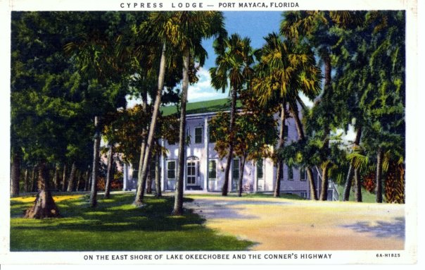
Historic Postcard courtesy of historian Sandra Henderson Thurlow.Back of post card
If one drives to end of Kanner Highway adjacent to the C-44 Canal connecting the St Lucie River to Lake Okeechobee, there is a gem to see. A place that will take you back to an earlier time. The name of this place is the “Cypress Lodge,” in Port Mayaca.
According the “History of Martin County,” this beautiful lodge first opened its doors in 1938 and is *now operated by Mr and Mrs Charles Dorrell functioning as a resting stop for tired motorist crossing the state from north to south, or east to west.”
Page 253 reads: “The lodge, boasting an outstanding cellar, is colonial in design, built originally as a tavern, has been operating ever since. The two-story all cypress building with a large dining room, is staffed mostly by residents of Pahokee, Canal Point, and surrounding towns. It is said more people work in Port Mayaca than live there.”
Just last week I learned that friend, and long time Stuart resident, Elsie Jean Stewart, has deep ties to the property as her parents were married there. She recently shared with me a wonderful family photo of the young couple. Their tremendous smiles in black in white were full of color. What days these must have been…
I recently drove out past the lodge on my way to Belle Glade while daydreaming what the area was like as in the mid-1800s between Seminole Wars. I saw a giant cypress forest full of wildlife and there was no dike around the lake, so from horseback, I could see over the wide expanse of Lake Okeechobee….
Those things are gone and the lodge was built later, but it is still connected. I have been curious to see the structure as I have been missing it on my recent drives to Belle Glade. On my last trip, I figured out that at some point the historic Connors’ Highway had been rerouted so now at the Lake, one must turn north rather than south to see the familiar structure.
When I found the lodge, I took some photos to share. Still beautiful. Still timeless. I believe today it is a private residence. Thankfully it is still here and remains a gem of Martin County’s fascinating history around Lake Okeechobee.
The Cypress Lodge and Port Mayaca are located west near S-308 at Lake Okeechobee. You can see the C-44’s connection from the Lake to the South Fork of the St Lucie River/Indian River Lagoon.
2-18-17: Correction!
Today I figured out, thanks to an article by the Luckhardts, that although not mentioned in the “History of Martin County” on page 252-3 , it was Paul M. Hoenshel of Miami who originally built and operated the lodge. Hoenshel is the grandfather of Elsie Jean Stewart whose “parents were married in the lodge” that I mention…. Jacqui
Our Indian River Lagoon neighbor to the north, Ft Pierce, was recently voted as one of Florida’s “most affordable beach cities.” I have always loved Ft Pierce, and felt like it was underrated. Growing up in Martin County I was aware of its history and some shortfalls, but Martin County has its fair share too.
These aerial photos were taken recently by my husband Ed Lippisch and his friend Scott Kuhns. They show the beautiful turquoise water the area usually experiences. Yes, Taylor Creek is attached to the C-25 canal and at time spews dark, polluted water primarily from draining agricultural fields, but work is slowly being done to improve the situation. As we can see from some of the photos, seagrass has suffered in this area from repeated poor water quality too.
In the mid 1800s the area was called Edgartown, famous for an oyster cannery and fishing village. It was later named for a lieutenant colonel and fort of the Seminole Wars. Ft Pierce was incorporated 1901.
One thing the area can consistently brag about is its usually beautiful water. Certainly a better bet than the St Lucie River/Southern Indian River Lagoon in Martin County. As one the most affordable beach towns in Florida, maybe it’s time to take out our checkbooks…
Photos show Ft Pierce around the IRL, Taylor Marina, the Ft Pierce Inlet, and C-25.
SFWMD canal and basin map. C-25 canal is the northern most canal in the image.
“History, Encyclopedia Britanica: Fort Pierce, city, seat (1905) of St. Lucie county, east-central Florida, U.S. It is situated on the Indian River (a lagoon connected to the Atlantic Ocean by inlets), about 55 miles (90 km) north of West Palm Beach. The fort (1838–42), built during the Seminole Wars, was named for Lieutenant Colonel Benjamin K. Pierce (brother of President Franklin Pierce), who commanded a detachment. Permanent settlement began around the fort site in the 1860s, and the small fishing village of Edgartown and an oyster cannery were also established. In 1901 these entities were incorporated as the City of Fort Pierce. Pineapple growing was an early factor in the city’s economic growth that was later replaced by citrus farming.”
Today I am sharing photos taken yesterday, 2-8-17, by my husband, Ed, over Langford’s Landing, the controversial development along the once high bluff of the St Lucie River located on the northwest border of Sewall’s Point in Rio. Of course this property was the long time home of philanthropist, singer, and movie star, Frances Langford and years after her death, as she wished, those handling her estate put the monies from the sale of this land towards the trust in her name and legacy of giving. Whether the nature-loving long time Martin County resident would have approved of the conditions of the sale, we can only speculate…I know what I think.
Even though the naked property remains visible from the bridges it is nice to see it close up. Thank you Ed for the photos!
As we can see, since December of 2015, all trees have been wiped out, the marina appears completed, the roads are in, the once historic high bluff is now flat and even, and few blades of grass are now visible.
Last week, Ed and I toured guests in the Baron to see elements of the Everglades Agricultural Area. It was a beautiful day and clear as a bell. “Clear as a bell” until the smoke from the burning sugarcane fields built up actually causing turbulence on the way home.
Witnessing the burning from the sky is quite dramatic and few get to see, thus I am sharing today. I took these photos in the area north of the east/west running Bolles Canal; there is a map below, but you’ll have to search to find the Bolles. Look right under Lake Okeechobee. I am also including videos, and educational links for understanding.
Jacqui
*The video above was taken in the EAA during a tour in 2016. Some viewers must go to web site to view:https://jacquithurlowlippisch.com
SFWMD map showing STAs and WCAs. (Storm Water Treatment Areas clean the water of excess phosphorus and nitrogen from agriculture and developement via vegetation and then flow into the Water Conservation Areas, from here the water has been cleaned of phosphorus and nitrogen and hopefully meets standards that allow it to go into the Everglades.)Senator Negron’s proposed land purchase of EAA lands for Everglades Restoration’s EAA Reservoir, 2017–a familiar map right now shown for education and perspective.
Witham Air Field in Martin County is north, just outside of the circles….the circles that designate “No Fly Zones”during Presidient’s Trump’s return home today to Mar-a-Lago in Palm Beach. Many Palm Beachers will be flying into Witham who can’t get into Palm Beach due to the flight restrictions. Perhaps as they pass through they will be learning about the vociferous but sleepy little town of Stuart, to their north, with the toxic water problems stemming from discharges from Lake Okeechobee?
Martin and Palm Beach counties have a long history. In fact, Martin County was formed of north Palm Beach County in 1925. Our destiny is connected…
Looking at the circles on the “Temporary Fly Restriction” map above, sent to my husband, reminded me of some other circles that are also causing a stir. Senate President Joe Negron’s proposed circles for land purchase in the EAA. I know you are familiar with that map! I hope President Trump reads the local paper while he’s here. Or maybe he’ll even get a chance to meet with the President of the Florida Senate?
As we know, in today’s world, anything can happen…
Circles showing Senate President Joe Negron’s proposed land purchase in the EAA
Below is an explanation of the NO FLY as explained by Palm Beach Post reporter Eliot Kleinberg, January 24, 2017
Planned flight restrictions when President Trump is at Mar-a-Lago:
A “no fly” zone in a 1-mile radius. Commercial flights that normally would leave or arrive on a straight line from PBIA must instead angle north or south.
A ring of 10 nautical miles bars all private planes from landing at either PBIA or Lantana unless they came from a “gateway airport,” at which they’ve been screened by the Transportation Safety Administration. Any planes that land at Lantana can’t leave until Trump is gone.
A ring of 30 nautical miles allows only planes traveling to or from fields outside the 10 mile ring, all of those closely monitored by air traffic controllers.
Banned at Lantana during visits: all flight training, practice approaches, parachuting, and flights of aerobatic aircraft, gliders, seaplanes, ultralights, gliders and hang-gliders, balloons, and even crop-dusters. Also banned: banner-towing and sightseeing, maintenance test flights, model rockets and aircraft, utility and pipeline surveys and drones.
A ring of 10 nautical miles bars all private planes from landing at either PBIA or Lantana unless they came from a “gateway airport,” at which they’ve been screened by the Transportation Safety Administration. Any planes that land at Lantana can’t leave until Trump is gone.
And a ring of 30 nautical miles allows only planes traveling to or from fields outside the 10 mile ring, all of those closely monitored by air traffic controllers.
More ominously for Lantana: the restrictions ban from that airport, at leeast while Trump is in town, all flight training, practice approaches, parachuting, and flights of aerobatic aircraft, gliders, seaplanes, ultralights, gliders and hang-gliders, balloons, and even crop-dusters. Also banned: banner-towing and sightseeing, maintenance test flights, model rockets and aircraft, utility and pipeline surveys and drones.
Below is the Report from https://www.aopa.org : Over Palm Beach, FL beginning Friday, February 3, 2017(((Change in times)))
30 NM RADIUS TFR
Location
On the PALM BEACH VORTAC (PBI) 094 degree radial at 1.6 nautical miles.
From the surface up to but not including 18,000 feet MSL.
2 NM EXCLUSION
Location
On the PALM BEACH VORTAC (PBI) 349 degree radial at 30.9 nautical miles.
From the surface up to but not including 18,000 feet MSL.
Location
On the FORT LAUDERDALE VOR/DME (FLL) 004 degree radial at 7.4 nautical miles.
From the surface up to but not including 18,000 feet MSL.
Times:
4:15 PM local Friday, February 3, 2017 until 11:30 AM Monday, February 6, 2017
10 NM RADIUS NO-FLY ZONE
Location
On the PALM BEACH VORTAC (PBI) 094 degree radial at 1.6 nautical miles.
From the surface up to but not including 18,000 feet MSL.
Times:
4:15 PM local Friday, February 3, 2017 until 11:30 AM Monday, February 6, 2017
Affected Public Use Airports
KPBI Palm Beach Intl
KLNA Palm Beach County Park
F45 North Palm Beach County General Aviation
KBCT Boca Raton
No pilots may operate an aircraft in the areas covered by this NOTAM (except as described).
Except as specified below and/or unless authorized by ATC in consultation with the air traffic security coordinator via the domestic events network (DEN):
A. All aircraft operations within the 10 NMR area(s) listed above, known as the inner core(s), are prohibited except for: Approved law enforcement, military aircraft directly supporting the United States Secret Service (USSS) and the office of the President of the United States, approved air ambulance flights, and regularly scheduled commercial passenger and all-cargo carriers operating under one of the following TSA-Approved Standard Security Programs/Procedures: Aircraft Operator Standard Security Program (AOSSP), Full All-Cargo Aircraft Operator Standard Security Program (FACAOSSP), Model Security Program (MSP), Twelve Five Standard Security Program (TFSSP) All Cargo, Or All-Cargo International Security Procedure (ACISP) and are arriving into and/or departing from 14 CFR part 139 airports. All emergency/life-saving flight (medical/law enforcement/firefighting) operations must coordinate with ATC prior to their departure at 561-684-9047 to avoid potential delays.
B. For operations within the airspace between the 10 NMR and 30 NMR area(s) listed above, known as the outer ring(s): All aircraft operating within the outer ring(s) listed above are limited to aircraft arriving or departing local airfields, and workload permitting, ATC may authorize transit operations. Aircraft may not loiter. All aircraft must be on an active IFR or VFR flight plan with a discrete code assigned by an air traffic control (ATC) facility. Aircraft must be squawking the discrete code prior to departure and at all times while in the TFR and must remain in two-way radio communications with ATC.
C. All flight operations not covered in paragraph A. within the 10 NMR area must be security screened by TSA at a gateway airport prior to arriving or departing Palm Beach International Airport (KPBI). Aircraft operators must register with the TSA for gateway screening no less than 24 hours prior to their scheduled departure time. Reservations for screening may begin on February 01, 2017 and last through the duration of the event by calling TSA at 561-616-9650.
D. Gateway airports have been created at Palm Beach International Airport (KPBI), Orlando International Airport (KMCO), Fort Lauderdale International Airport (KFLL), Dulles International Airport (KIAD), Teterboro Airport (KTEB), and Westchester Co. Airport (KHPN) by TSA to accommodate aircraft arriving or departing Palm Beach International Airport (KPBI).
E. TSA screening will not be available on Friday 2/3/2017. TSA screening will be available from 1702041300 UTC (0800 local 02/04/17) to 1702042200 UTC (1700 local 02/04/17), 1702051300 UTC (0800 local 02/05/17) to 1702052200 UTC (1700 local 02/05/17), and 1702061300 UTC (0800 local 02/06/17) to 1702061500 UTC (1000 local 02/06/17). Pilots, crew and passengers must provide valid government-issued photo identification to the TSA at the gateway airport. Gateway screening will include id verification and vetting of all pilots, crew and passengers, screening of persons and baggage, and inspection of the aircraft. No firearms on board aircraft will be authorized.
F. On departure from a gateway airport aircraft must maintain radio contact with ATC and continuously squawk an ATC-assigned discrete code. Intermediate stops while enroute are not authorized unless an emergency exists.
G. The following operations are not authorized within this TFR: flight training, practice instrument approaches, aerobatic flight, glider operations, seaplane operations, parachute operations, ultralight, hang gliding, balloon operations, agriculture/crop dusting, animal population control flight operations, banner towing operations, sightseeing operations, maintenance test flights, model aircraft operations, model rocketry, unmanned aircraft systems (UAS), and utility and pipeline survey operations.
H. FAA recommends that all aircraft operators check NOTAMs frequently for possible changes to this TFR prior to operations within this region.