The hand made dugout canoe is the precursor of today’s paddle board and was used by many Florida Native American tribes for transportation along the Indian River Lagoon. (Painting, by Ted Morris, Ais Indian warrior hunting along lagoon. Courtesy of historian Sandra Thurlow.)River Kidz member, Mary, paddle boards in the St Lucie River/Indian River Lagoon, at Paddlefest 2013.
I find the recent craze in paddle boarding fascinating and symbolic. The culmination of this craze locally occurred this past weekend with “Paddlefest 2014,” organized by Mike Flaugh and Cam Collins. Hundreds of young people and adults were able able to get on the water, many for the very first time, to make a personal connection with the St Lucie River/Indian River Lagoon.
As we navigate our waters today, we must keep in mind the history of other Florida people’s who used a similar, handmade, “standing,” basically flat board, hundreds of years before us. Most notably, here in Stuart, the Ais Indians and later the Seminoles.
“Florida Memory Project, “artist unlisted/subject, Seminoles on dugout canoe, near Lake Okeechobee.Locations of the historic Native American Tribes in South Florida. (Map, public.)
The Ais lived prior to the mid 1700s roughly from Stuart to Titusville, before their population was decimated by the Spanish; the Seminoles came to Florida from the Southeastern United States to avoid capture, and they too used dugout canoes, very similar to today’s paddle boards to move through the waterways and swamps.
Ebbs photograph of Seminole man in full regalia on dugout canoe, late 1800s early 1900s.
I think the fighting and earth protecting spirit of the Indians is coming back with each person who takes up paddle boarding. In the 1600s, Jonathan Dickinson and others documented the Ais as the most warlike of all Florida tribes never succumbing to their captors, the remaining few left for Cuba. And the Seminoles? We know that story, they outsmarted the US Government, retreating to the interior of the Everglades, and never surrendered.
With a blessing and a plea for forgiveness, for our Native Peoples’ exterminated by prior generations before us, may their spirt protect and inspire us, in our modern fight against our US and State Government, and in many ways ourselves, to save the beautiful, the sacred, the Indian River Lagoon.
Hundreds of children and adults paddle boarded thanks to Costal Padleboarding at PADDLEFEST 2014, many for the very first time!
The Jensen Beach Bridge’s causeway, built in 1957-58, severely blocked the flow of the Indian River Lagoon, impacting its flow like a choked artery. Many causeways along the lagoon continue to do this today. (Photo courtesy archives of Sandra Henderson Thurlow.)
“Take your hands off my neck, ” she whispers…
The Indian River Lagoon is not a “river;” she is a “lagoon.” She has no “headwaters “like a true flowing river, but is rather a 156 miles depression along 40% of the Florida’s east coast. The lagoon once contained naturally cleaned waters from surrounding vegetated lands, brooks, larger tributaries and had the benefit of naturally opening and closing inlets to the ocean.
Today not only are its inlet fixed, but the lagoon’s water contains run off from polluted/populated surrounding surface waters, naturally rising and falling salty/nutrient filled groundwaters, and those of impacted water bodies like the Crane Creek in Melbourne or the St Lucie River in Stuart. These water bodies have been channelized and engineered to take on sometimes as much as 50% more fresh water through drainage of lands and lakes than than Mother Nature planned; of course, it ends up in the IRL as it goes to sea.
The lagoon’s water moves only through tides and wind. In some areas of the lagoon where there are no inlets, it is estimated that the water can remain “there” for over three years or more. Even close to an inlet, like here in Sewall’s Point, causeways heavily impact the ability of the lagoon’s water to move and flow cleaning itself, becoming becoming stagnant.
The lagoon was formed over many ice-ages with the rise and fall of the ocean. According to the History of Martin County, “evidence of comparatively recent rise of ocean levels during the past 10,00 years is frequently found in the spoil and dredging of operations along the Indian River through fossils of giant mammals.”
It may have taken thousands of years for Nature to form the lagoon but mankind is close to destroying it in just under 100; one of the primary ways of doing such was/is through the building of causeways to support bridges to Hutchinson Island.
There have been and will be opportunities to improve this situation, most recently in 2004, in Martin County, when the Ernest Lyons Bridge located between Sewall’s Point and Hutchinson Island, was being rebuilt, this problem was addressed, but not corrected, as the public at the time was unwilling to give up its access to the causeways. The causeways were lessened but not removed.
The causeways don’t just impact the water flow but also the lagoon’s wildlife. I remember my parents telling me stories in my youth about the fisherman of early Jensen noting that the causeways sticking out into the “river”confused the migratory fish that had followed its shoreline as navigation to the inlets for thousands of years.
We will have an opportunity to rebuild the bridges before the next thousand years, my vote is remove the causeways and stop choking the already suffocating Indian River Lagoon.
This snowy egret was visiting the retention pond, across from Indialucie, in Sewall’s Point. The bird exhibits some of the most excessive foraging behaviors and has what is considered the most beautiful mating plumage of any wading bird and bright yellow feet! It hunts in wetland habitats. Plume hunters decimated its population by up to 95% but since protected, the birds have made a comeback. (Photo Sandra Thurlow, 2014.)
Every day, I look to nature for inspiration, hoping for a model of success to save the St Lucie River/Indian River Lagoon.
One of the “greats” is the little snowy egret. All wading birds were almost hunted to the point of extinction during the feathered ladies hat craze of the late 1800s and early 1900s, and because the snowy egret was the most desired of all birds for its beautiful nuptial plumes, it, more than any other wading bird, was hunted.
There was great motivation to hunt birds as at the time, their feathers were worth more than gold.
It is well documented that the plume hunters shot birds by the thousands in rookeries through out Florida, especially the Everglades, during breeding season when the birds’ feathers were most beautiful. The birds were shot right off their nests with the baby birds left to die. Entire rookeries disappeared.
After witnessing such, many hunters reported feeling sick at the “sight of thousands of little hanging necks over the nests” and “repented,” refusing to go back after being part of such cold blooded carnage.
But times were tough and there were alway more men behind them to take their place. In the late 1890s the Ornithologists’ Union estimated that five million birds of all kinds were killed annually.
“Little Snowy” was most hunted for its “nuptial feathers” that grow during mating and baby bird season. During the late 1800s and early 1900s the birds were commonly shot off their nests. (Public photo.)
The story of what birds remain and have rebounded is yet another story of American inspiration though everyday people demanding more of their government.
In 1886, Forest and Stream editor, George Bird Grinnell, was “appalled by the negligent mass slaughter of birds.” Based on studies of painter John James Audubon from Ornithological Biography, he created an organization devoted to the protection of wild birds and their eggs. Within a year the the Audubon Society had over 39,000 members including very prominent figures of the day and eventually a US president. Their numbers and financial support grew and the organization evolved throughout many states. Letter writing campaigns ensured, many from churches, state laws were passed starting in New York, banning the sale of plumes, and by 1920 similar laws were passed in other states. In 1918 US Audubon lobbied for the Federal “Migratory Bird Treaty Act” and convinced the US government to support the National Wildlife Refuge system, the first being Sebastian, Florida’s “Pelican Island.” Today migrating and resident birds are protected, or at minimum, regulated, by hunting license in all communities.
Snowy egret in breeding plumage and colors. (Public “wallpaper” photo.)
So again, the stories are many of mankind’s propensity to kill the world around “him,” and then to pull back from the brink of total destruction by the intervention of a small group of people.
The story of the Indian River Lagoon will hopefully be a similar tale to tell. So when you are around town and see a little snowy egret, feel inspired!
This aerial photograph is from Sandra Henderson Thurlow’s book, “Sewall’s Point, the History of a Peninsular Community on Florida’s Treasure Coast.” The photo was taken by Dillon-Reynolds Aerial Photography in 1968, ten years after the “bridges to the sea” were built to aid in transportation and development of the area.
Imagine yourself a developer in Florida’s early days along the St Lucie River/Indian River Lagoon. Land is cheap, people are coming, you can dredge and fill, you can create a marina, or bulkhead spoil islands filling and building on top of them, you can cut canals into the land creating more waterfront, and while you are smoking your cigar, you see the peninsula of Sewall’s Point. “Location! Magnificent! A perfect place for a series of hotels right at the tip of the lush pennisula surrounded by water…this would be, simply marvelous!” “Chi-$-Ching!”
Believe it or not, in 1957-1970 that scenario was very much the fate of the Sewall’s Point and the two islands off its tip. The 1957 zoning map, the year the town was incorporated, designated High Point, and the two islands at the southern tip of the peninsula as a “Business-2 Zoning District.” This zoning designation permitted “hotels with not less than 25 rooms, clubs, multiple apartments, and municipal buildings.” (Historic legal documents referenced in Sewall’ s Point, Sandra Henderson Thurlow).
Sewall’s Point zoning map 1957 shows the tip of High Point and two islands zoned for “business.” (Map, Sewall’s Point, Sandra Henderson Thurlow)
So why did not this developer’s dream come true?
“In 1970, a proposal to build multi-family dwellings on Sewall’s Point fell through when the members of the High Point Homeowners Association, working through the town government, defeated the the plan of Bessemer Properties.” (Thurlow) This was a feat, in that Bessemer was controlled by the Phipps family with wealth from steel manufacturing; they were very powerful.
In 1970, after the confrontation, the town’s zoning map was changed to permit only R-1 residential zoning.
So, if you ever feel discouraged about the state of the Indian River Lagoon or other things, think of the story of Sewall’s Point, and remember, a small group of determined people can certainly change their world!
Aerial of Sewall’ Point, 1960 by Dillon-Reynolds Photography, showing new roads in Bessemer’s High Point sub-division.
Tumored needlefish are more common in the Indian River Lagoon than anywhere else in the state. Why? (Photograph, public study, 1999-2009, by the Florida Wildlife Commission.)
I have decided to do a series of writings on the sick animals of the Indian River Lagoon because a “picture speaks a thousand words.” I am not trying to “focus on the negative,” or be a “hysterical woman.” I am trying to effect change.
I have heard about the sick animals, fish and bi-valves in the Indian River Lagoon “up close” at Harbor Branch Oceanographic Institute’s, “IRL Symposium” of which I have attended the past three years, since it has been resurrected. At these symposiums, students, state agencies and others share information. In fact, all of these individual agencies and scientists share information on their websites, but for some reason, it never really goes “public.”
So I will post this on Facebook and see if these sad stories that should be a call to our state federal,and local governments, get a bit more coverage. As we know, it seems the people have to scream before the elected officials and agencies pay much attention to the fact that the beautiful Indian River Lagoon world we are living in is contaminated and crumbling before our very eyes.
So, to get back to the study, the Florida Wildlife Commission (FWC) did comprehensive research between 1999 and 2009. Ironically, 2009 is also the year the seagrass started to dip, foreshadowing the massive die off of seagrasses and marine mammals in the northern lagoon. The FWC study focused on the “Distribution of Lymphosarcoma in Redfin Needlefish, in the Indian River Lagoon.”
Redfin needlefish are approximately 380 millimeters, to me they look like miniature barracuda with smaller teeth and are pretty cool, shiny, little fish. They live about three years, commercially serve as bait fish for marlin fishing, and are an important shallow water predators, eating lots of little bottom living critters, lower on the food chain.
Generally, tumors are caused by chemical carcinogens, radiation, and viruses and can be benign (OK) or malignant (bad). The study included Tampa Bay; Charlotte Harbor; Apalachicola; Cedar Key; the St Johns River, and the Indian River Lagoon. Tumors were found on jaws, flanks, the trunk dorsal fin, the pectoral fin area and the head. The prevalence of these usually malignant tumors, in over 20,000 needlefish studied, specifically and especially in the Indian River Lagoon was astounding.
The highest area of tumors was the Banana River. The Banana River is part of the IRL system and is located mostly south of NASA in Brevard County. As mentioned, it is also where the highest seagrass loss was during the super-bloom of 2011. This super-bloom was followed by a secondary bloom and Brown Tide that spread south, just north of the Fort Pierce Inlet, also killing seagrasses and wildlife.
I am no scientist, but it seems like the Banana River has some serious issues. Of course we would not want to jump to any conclusions….We wouldn’t want to frighten the public…..We wouldn’t want to hurt tourism, especially now.” Shhhhh!”
Tumored needlefish were also found in the southern lagoon, but not the majority. I feel better already. NOT. The lagoon is a system, the animals and fish know no county lines nor do the tides, wind or water. Even if water does not move much, sickness can spread or point to latent problems of our own. We must think as “one-system,” and help each other as one entity, if we are going to save this lagoon.
The study of which is included in this post below, has a bullet point that says “no tumors were found after 2009.” Noting that there is no clue when the study ended, this seems odd.
Hmm….. I wonder if that’s because there was no money put forth by the state for more comprehensive studies after the financial crisis of 2008? I wonder if its because the wonderful hard working people at the state agencies were afraid if they were too brazen the state would fire them? Believe me this happens.
Personally, I think the State of Florida, local governments, and the Department of Environmental Protection have some information to share, and some more research to do, for the little fish, and for us.
Gubitorial candidates wrote directly to the residents of the St Lucie River/Indian River Lagoon area on May 8th, 2014 in the Stuart News.
I didn’t pick up Sunday’s Stuart News until Monday, as I had been out of town. Sipping my coffee and holding the old fashioned paper, I love so much, my lips curled in a broad smile. The opinion page juxtaposed articles by two candidates running for Florida governor: Nan Rich and Rick Scott.
These letters were not just broad sweeping letters; they were thoughtful and personal, they mentioned the River Warriors and direct stories of inspiration from local residents. Don’t get me wrong, I know it is an election year, but nonetheless, it is simply amazing. In one year, since the discharges from Lake Okeechobee and our local canals turned our world upside down, and news of such “went viral,” the people have accomplished the most impressive of our forefathers’ American expectations. Expectations that years of social conformity and acceptance of over-development and pollution had overridden. The people of the Indian River Lagoon have stood up to their government.
The rebellion of the southern lagoon corresponded to the northern lagoon’s massive deaths of manatees, dolphins, pelicans and loss of almost 100% of its seagrasses. These die-offs and toxic algae blooms in the north, actually began happening in 2011 but did not come out publicly until the uprising in the southern lagoon blended the two tragedies.
I know for many of my friends the politics of the River Movement is hypocritical, frustrating and painful. I feel the same way. In fact lately I have been a bit depressed over the whole thing. But I am getting out of it. Boy is it a pleasure to see that paper, to be in the drivers seat, to have “them” writing letters, visiting, and actually thinking that there is no longer a “golden ticket” to pollute. I have been in Martin County many years, and on “this level,” “this” has never happened before.
Finally, even Senator Rubio is getting heat in the press; long standing Senator Nelson is happy he’s been around, but also nervous he is part of the lagoon “establishment;” Charlie Crist is taking out his old notes about US Sugar; Senator Negron is promising more for the lagoon in 2015; Congressman Murphy is regrouping and studying the Farm Bill after the ACOE refused CEPP on his watch; and the future speakers of the Florida house and senate are making their cases for the future of “water.”
Many times the lagoon has been defiled by our government, in fact 2013 was not the worst its ever been. But I am telling you, this time it is different because of “us.” This time we have exposed them. This time we are asking truly for government to do what it is supposed to: “protect the health; safety and welfare” of its people. This time we are united in a brotherhood and sisterhood of diverse backgrounds and interests. This time we have reached a tipping point, as has the lagoon.
And most important for change, this time, “they” are watching and listening to us.
Please take advantage of this opportunity. Don’t turn your back because the politics are so repulsive to watch. Look to the sky—look to the river ——write a letter or make a call and say : ‘thank you; we are happy you are taking an interest in the lagoon; I will be weighing who to vote for based on who really has the desire, passion and an honest heart.”
These politicians may never be able to reach perfection, their world is pretty insane, but be grateful they are paying attention, and know you are a force for change in a way never before. Drive your points home!
FIT-Florida Tech, in Melbourne, is where the Marine Resources Council’s “Lagoon Action Assembly” was held. (Photo Jacqui Thurlow-Lippisch, 2014)
From what I understand, there had not been a “lagoon assembly” for seventeen years. The last assembly had been the genesis of the Indian River Lagoon’s National Estuary Program, NEP, that is linked to the US Environmental Protection Agency, (EPA).
The IRL NEP, over the years, became linked and partially funded by the St Johns River Water Management District. Just recently there is gossip of “change” and major positions in the NEP have been “rearranged.”
In all honestly, this change was not discussed much at the IRL Assembly this past weekend, but it will affect the assembly either way.
Thank you to the Marine Resources Council, MRC, located in Melbourne, Brevard County, three counties north of Martin, also along the lagoon, who decided to take on the challenge of organizing the “IRL Action Assembly” for 2014. Dr Leesa Souto oversaw this enormous goal involving up to 100 delegates.
I was invited to attended the meeting and I thought I would give a short summary of my experience.
So, I went up Thursday evening to the “Lagoon House,” the home of the Marine Resources Council; there were introductions, and the primary speaker was Wayne Mills who spoke on the history and present of the Chesapeake Bay Foundation. Although the US’ largest estuary, Chesapeake Bay, remains terribly polluted, they are making calculable progress and have even been sued by the state of Florida and others because the foundation’s research is leading the way in limiting agricultural and other pollution into waterbodies, a frightening and expensive prospect for the states.
The following day, we met at Florida Tech, on a beautiful campus and a beautiful day. We gathered in the old lecture hall like students, under the eye of the periodic table, and listened to speakers: Virginia Barker, Brevard conservation; Dr Grant Gilmore, fish studies/habitats; Adam Schaefer, sickness in IRL dolphins, HBOI ; Dr Leesa Souto, MRC; Dr Charles Jacoby, seagrass loss, SJRWMD; Robert Weaver, FIT inlets/flushing; and Dr John Trefry, general lagoon health demise. Their presentations were excellent and disturbing. The most interesting new piece of information for me came from Ms Barker’s statistics on how much groundwater goes into and affects the IRL along with surface water runoff. According to Ms Baker, groundwater holds pollutants that build up from the land, like fertilizers and septic seepage, and often tremendous amounts of salt. She says most canals are cut so deep in Brevard County that the groundwater is constantly “pulled up” and flowing back into the IRL.
Then they split us into groups. In my “A Group” were Dr Edie Widder, ORCA; Matt Thorton, Syngenta; Ed Garland, SJRWMD communication; Jeff Beals, FFWC/SJRWMD; Tim Zorc, IRC Commissioner; Dr Jan Landsberg, Florida Fish and Wildlife Commission; Mike Merrifield, Wild Ocean Seafood Market, Titusville; and Carol Nobel, Cocoa Beach, Brevard County.
Classic “Dr George” from FIT was our facilitator and two young and “wanting to please” students were our scribes. We sat in a circle facing each other, tasks with “saving the lagoon.”
The group was led through a series of questions and then we had to address two of four topics: septic tanks; drainage canals; agricultural lands; and residential lands. After excruciating conversation, we addressed two topics: septic and ag lands. We wrote our outcomes on large pieces of paper to share with the other nine groups later on. This took two days and we also dealt with more questions and concepts. It was overwhelming and the task makes one realize the difficulty of the situation.
When we all reconvened in the lecture room we read each others sheets and voted on which ones we would support. At this point the MRC is compiling these goals and will summarize and prioritize consensus actions for the assembly.
I don’t know if the assembly will be able to save the IRL but I sure they will provide direction. Every time I attend these type of meetings I meet wonderful people, people who want to save the lagoon as much as I do from different backgrounds and areas than myself.
I really liked and learned from the people in my group. As usual, I felt like the “Good Lord and Universe” were on my side in that Dr Jan Landsberg was in my group.
Dr Landsberg is THE person who has overseen the marine mammals deaths of manatees for the IRL and the Florida Fish and Wildlife Commission. She operates out of St Pete. Speaking to her at lunch I learned how low their funding is and how they have been dealing with the 150 plus dead, bleeding from the nose and eyes, manatees that have come into their agency in the past year mostly from Brevard County.
“The seagrass is completely gone, right? ” I asked.” Why are the manatees still up here? What are they eating?”
Jan replied, ” they are eating drift algae and some of that algae is toxic…”
“Gulp.”
Also, at lunch I learned from Dr Eddie Widder that once a waterbody is “seeded” with toxic algae it is forever there, in the sediments and soils. It never goes away. You could lessen it by removing muck but the seeds/spores will always be somewhere. She also mentioned, while eating her salad, that the pharmaceuticals people take also end up in the lagoon…
“Pass the ketchup, please.”
Mike Merrifeld, Titusville, who runs a seafood business told me he had seen my photos of the southern lagoon debacle last year, and “his” fishermen believe the pollution went up the Gulf Stream from the St Lucie Inlet and has majorly affecting fishing/shrimping productivity in the Brevard area. I believe him.
“I’m not really hungry anymore….”
So in the end, we must join together and force the US EPA and the FL DEP to do their job. And we too must do everything we can ourselves to save the IRL. Because one thing is for sure, “we are killing it.”
With the hope of the Chesapeake Bay model, goals from the Action Assembly and an infuriated public, our policy makers can no longer hide and must rise to create policy that many will not like, but of which all will benefit, in that our grandchildren, just might be able to fish and swim, or see a manatee or dolphin, in a beautiful Indian River Lagoon.
Ten thousand years ago some of the largest mammals ever known lived along the Indian River Lagoon. (Photo Jacqui Thurlow-Lippisch.)
I am in Melbourne, Florida, serving as a delegate for the Marine Resources Council’s Action Assembly of the Indian River Lagoon. I got here early and started reading up on this area of the lagoon that is suffering from marine mammal deaths of manatees and dolphins. Brevard County holds 60% of the lagoon and basically just about all of their sea grasses are now dead and though over nitrified water certainly fed the super bloom that killed the sea grasses, scientists feel there is more to the story. But scientists are not allowed to just feel, they have to “prove” so the struggle to explain what happened continues…
The assembly is being held at Florida Tech, which sits close to Crane Creek, a tributary of the IRL. About 10,000 years ago Mammoths lived here and their gigantic skeletons have been excavated. Paleontologist have also found bones of mastodon, horses, camels, the 20 foot tall ground sloth (the largest mammal to ever roam North America) along with tapir, peccary, camel and my favorite, the incredible saber-toothed cat.
Although humans also lived in this area 10,000 years ago, it was not until modern times that Crane Creek was drastically altered. In 1922, after the times of the pioneers, efforts to drain the area under Florida statute 298 were successful and the M-1 canal along with with feeder canals dried the lands of the surrounding area and inland along the St Johns River for agriculture that the real estate ads had promised.
Today the area is highly populated and is the home of a struggling NASA. A six lane highway abuts the once beautiful Indian River Lagoon and concrete is everywhere.
of course, times change, still it is hard to picture Mammoths walking around here! I wonder what this area will look like in another 10,000 years? Maybe something weirder than a 20 foot sloth or humans will walk or climb. Maybe something smarter? I hope.
The delay of CEPP, the Central Everglades Planning Project, may end up symbolically being the beginning of Florida’s 4th Seminole War as people fight for water to move south. (Photos public.)
I really did not want to write about the failure of the Central Everglades Planning Project, CEPP, as I have been trying to forget about it. The whole thing is so depressing to me. However, last night, before I went to bed, my husband said, “Dan thinks you should write about what’s going to happen now that CEPP did not make it into the WRDA bill…” So, I had a long series of nightmares, now it’s morning, and for Dr Daniel Velinsky, I will do the right thing, and try to write this piece.
First some history.
It is well documented that Florida’s three Seminole Wars were the longest, bloodiest, and most costly of all the Indian wars fought by the United States, fought on and off between 1814 and 1858. In the end, no treaty was signed and the few hundred remaining native peoples hid in their well known Everglades swamp to resurrect themselves as today’s Seminole, Miccosukee, and unaffiliated Independent Seminole Tribes.
They never surrendered and today their successful 1980s/1990s law suit against the Federal Government and the State of Florida requiring the polluting of Everglades Agricultural Area run off water onto their lands, to be reduced from sometimes over 300 to 10 parts per billion/phosphorus, in my opinion, is a key reason, along with its tartiness and other issues, why CEPP was not included in the Water Resources Development Act, WRDA, bill by the U.S. Army Corp of Engineers.
I can hear the D.C. ACOE now: “Even if we had the designated land, the mass of water could not be sent south—it’s too dirty. We need so much more land to clean it. So we’ll build all this structure but we won’t be able to send but a dribble of water south…Florida has to lessen the water quality requirements or …”
Well first of all, I say “kudos” to the Seminole and Miccosucci for holding the state responsible for cleaning up its water, even if it is an”impossible” number to achieve under present circumstances. I’d say in the karma department, “we had it coming.”
So now what do we do? Well in my opinion a type of war is going to start, and I liken the people of the St Lucie River/Indian River Lagoon to the “Fourth Indian War Warriors.” We will not surrender.
The failure of CEPP to pass will historically be the beginning of this war. And like the Indians of the 1880s, we were indirectly lied to, and part of it was our fault for believing what we were told, knowing the facts of history.
We all watched and participated along with the South Florida Water Management District and the Jacksonville Army Corp of Engineers for three years, putting full concentration of resources and creativity– forcing dedicated staff from both agencies to produce a document, CEPP, that the US Army Corp of Engineers more than likely knew, would never make it. So now, “they” want us to continue rallying for another two years for next WRDA bill. “Oh sorry maybe it will be seven years….”
I don’t think so.
Guess what? The people are tired of waiting. They put their money on the state and federal governments’ horse, and our horse wasn’t even allowed to run.
Do you feel the chain pulling and digging into your neck? I do.
This tactic is not new, and honestly I think it is simply part of a dysfunctional federal and state government. Let’s look back.
In the 1990s governor Lawton Childs had the state halt the famous water quality law suit and actually “laid down his sword” in a courtroom-how courageous, but look where we are now; in the mid 2000s Charlie Christ’s “Sugar Land Deal” was downsized due to the Economic Crisis of 2008 and other politics; before that, Jeb Bush started the “Acceler8 Program to quickly complete eight of over 60 Central Everglades Restoration Plan’s (CERP) projects. The SFWMD, functioning under the governor, worked diligently like they did recently for CEPP–the eight projects were not completed; and since 2011/12, under the Rick Scott administration, the entire focus was on CEPP, which also would have bundled some of the CERP projects to begin “moving faster” and to “move the water south.” After years of laser like dedication, for now, the project is “dead.”
Florida has water quality and quantity issues brewing like a hurricane, and our Indian River Lagoon area will be the eye in November of 2014, as former governor Charlie Christ runs against Governor Rick Scott. The race would have been messy anyway, but now it is going to be war as the different sides configure how to “send the water south” with out CEPP. Start thinking about how you want to send the water south or stored, and “never, never, never give up.”
“End of the Rainbow,” South Florida. (Photo by John Whiticar, 2013.)
As we approach hurricane season, we must prepare for rain. Florida is more like Africa than the rest of the county in that there are really only two seasons: dry and rainy. “Officially,” rainy season runs from June 1st to November 30th, and dry season is from December 1st through the end of May.
One of the most interesting accounts I’ve ever read of a “great south Florida rain” was published in 1886 by pioneer Charles Pierce, member the famous Hannibal Pierce family, to which our illustrious Indian Riverkeeper, Mr Marty Baum belongs. We along the St Lucie/Indian River Lagoon are part of the south Florida great rain system and there are reoccurring themes whether here or farther south, as l think you’ll see as I share the story.
Charles Pierce is most well known for his book “Pioneer Life in Southeast Florida” written about the years 1870 through 1894, and published by Miami’s University Press in 1970. It is a five star classic. According to a write up on the book, during this era of Florida history around 724 people were living between Stuart and Miami.
My mother, historian Sandra Thurlow, shared an excerpt that Charles Pierce wrote for the Broward Legacy in 1886, as he was living and overseeing the Biscayne House of Refuge at the time.
According to Pierce:
“In October of 1884 occurred the greatest and longest rainfall ever known on the east coast since its earliest settlement. It poured down for eight days and nights, slacking at times for a few minutes, but never stoping; then came down harder if that were possible. The whole southern part of the state was inundated…
On the eighth day the rain stopped and the next day came in bright and clear, and the sun shone brightly on a rain-soaked Florida…
I was on the east porch looking out to sea…looking up the coast to the northward, I caught the glint of something white about four miles away. At first, I thought it was a sea gull, then it looked like striking fish. I was not certain which it was, so I went for the old long spyglass to get a close up view of the scintillating white. What the spyglass revealed surprised me. The flickering white I had seen was now clearly shown to be whitecaps or breaking seas at the head of a dark body of water rushing down the coast….a mass of dark water some hundred feet in width rushing along to the south and with breaking seas over running the blue water in front.
It was a strange sight and at first we all wondered where it came from. My father Hannibal solved they mystery when he said, ‘It is fresh water from the New River Inlet.’ Could that be possible? It was fourteen miles away but there was no other solution to the phenomenon.
What a mighty volume of water must be coming out of the inlet and with tremendous velocity enough to overcome the resistance of wind and sea for so many miles. By night of that day the entire ocean in sight of the Station was covered with dark coffee-colored freshwater from the New River. Not a bit of blue water to be seen in any direction. Biscayne Bay was fresh for nearly a month after the week of rain.”
Incredible. So even before humankind diked and channelized the entirety of south Florida, when it rained heavily, the black wave of fresh water pushed forth through the south eastern inlets to the ocean; it did not just “go south.” We see a similar but not as intense phenomenon today, although drainage has been modified, when a heavy rain gushes through the St Lucie Inlet, Ft Pierce or Jupiter Inlets. In any case, when one hears a story such as Mr Pierce’s it makes one wonder, with all that water, during a really “great rain” a rain that comes only once in a few hundred years, will our manmade structures hold?
We all know the Army Corp of Engineers, along with support from the South Florida Water Management District, is working diligently to harden the dike around Lake Okeechobee, but it seems that a third outlet, a flow way south, from the lake to the Everglades surely would alleviate some of that natural pressure, the pressure Charlie Pierce describes as a
“tremendous velocity…”
If he were alive today, I wonder what Mr Charles Pierce would think?
Years ago, a common sight, “dredge and fill. “Canals cut into the land prior to the United States’ “environmental movement” that affected Florida State law. Photo: Stiller property and fish camp in 1964. This area was developed later in 1973 as Mariner Cay and is located on St Lucie Boulvard on the Manatee Pocket, Stuart. (Photo archives of Sandra Henderson Thurlow.)
When it becomes discouraging and we feel as though we will “never” be able to fix the St Lucie River and Indian River Lagoon, it is helpful to review environmental accomplishments of the past.
I was born in 1964 and a common thing to see in Martin County when I was growing up was development of coastal lands in a way that is rarely seen today-the cutting of canals right into the land abutting the river. Some of our most popular communities are based around the dredging and filling or the lands, or lands that had been cut earlier and then “improved.” To name a few, North River Shores; Mariner Cay; Stuart Yacht and County Club; Archipelago, Sewall’s Point; Francis Langford’s Marina; Snug Harbor Marina; Sailfish Point and Marina; Indian River Plantation; Circle Bay Yacht Club. There are many more. The city of Ft Lauderdale was almost entirely developed and marketed this way, “Venice!”
Although the outcome is often “pretty,” in the long term, there are huge environmental consequences to dredge and fill and this type of work is not “encouraged” for riverfront residential development today. Why? How did this common practice, so destructive, become more restrictive? This is the question I asked my attorney brother, Todd Thurlow, and this was his answer”
“Increased state regulation is probably in accordance with Federal Law. This is a whole area is study in federalism, environmental law and the federal government’s ability to influence the states to regulate themselves.”
Hmmm. To “regulate ourselves,” what a concept….
I started researching, and even though I was familiar, it helped to review the environmental movement of the United States. Historically, there had been conservationist like president Teddy Roosevelt and others but it was not until the late 1960s and1970s after an oil spill in Santa Barbara, California, that the US environmental movement really gained momentum. Remember it was the people who moved mountains not the government…
With pressure from the public, in 1969, what is considered the “magna carta” of US environmental law was passed, the National Environmental Policy Act (NEPA). NEPA “established a U.S. national policy promoting the enhancement of the environment and also established the President’s Council on Environmental Quality (CEQ). It is one of the most emulated statutes in the world.”
NEPA’s most significant effect was to set up procedural requirements for all federal government agencies to prepare environmental assessments (EAs) and environmental impact statements (EISs). (We see the these requirements hold today even with All Aboard Florida.)
NEPA led to the creation of the US Environmental Protection Agency, EPA, along with the very important Clean Air and Water Acts of the 1970s. In response to this federal pressure, the state of Florida merged agencies creating the Department of Environmental Regulation in the mid 1970s. Today this agency has adapted to be the Department of Environmental Protection.
The apex of the movement was a book published in 1962 by a former Fish and Wildlife employee and marine biologist, Rachel Carson, Silent Spring, that shined a light on pesticide use post World War II in the US and led to near banning of the common chemical DDT. Even though the powerful chemical companies fought the publication of the book, threatening to sue for libel, they lost and the pressure of the public’s “want to know” overcame….
The thread here? The people caused the change. Do not rely on the government for change, create it yourself by exerting pressure on your government. Whether this happens on the level of the United States environmental movement or the River Movement of 2013 here at home, the key to change is the people. Hope you learned or remembered something and that you feel inspired. Keep up the good work!
An ad for the town of “Port St Lucie,” by Sewall’s Point Land Company that ran around 1913. It reads: ” Sewall’s Point Land Company is developing the new town of PORT ST LUCIE in the northeasterly corner of Palm Beach County at the junction of the St Lucie and Indian rivers, directly opposite the St Lucie Inlet.” At the time, this area was Palm Beach County, today it is Martin. (Ad courtesy of Tom Thurlow)
I have often wondered why Port St Lucie is inland. Where’s the port? Well apparently the name “Port St Lucie,” had been around before the City of Port St Lucie was incorporated in 1961, as originally Port St Lucie was going to be a town that would have been in today’s Martin, not St Lucie County.
The above ad ran around 1913 and was part of Henry Sewall and Hugh Willoughby’s Sewall’s Point Company’s original development campaign to develop Port Sewall and Golden Gate as the “Great Port of Stuart.” At the time, this area was Palm Beach County but became Martin County in 1925.
Under the ad’s photo it reads: “Looking across one of the Lakes toward the St Luice River and the Inlet.” I imagine the lake was either North or West Lake, still located in today’s Willoughby Creek area. The ad also states that the location of Port St Lucie will be “directly opposite the St Lucie Inlet.” Viewing a copy of the 1911 Port Sewall promotional map below, one can see exactly where that is located, Old St Lucie Boulevard, Stuart.
The advertisement in the long winded style of the day continues:
“The lands west of the railway is laid out in tracts for FARMS and GARDENS. East of the railway are the business lots and large residence lot for the PORT OF ST LUCIE and the WATERFRONT is divied into lots of about two acres each for FINE RESIDENCES and WINTER HOMES. Ten acres are reserved for a PARK and five acres for a large TOURIST HOTEL on the water front. Situated at the junction of the St Lucie and Indian Rivers and St Lucie Inlet with a climate tempered by the soft breezes from the GULF STREAM and every month in the year a GROWING MONTH and FRUITS, FISH, FLOWERS and VEGETABLES in abundance….TENNIS, FISHING, MOTOR BOAT, SAILING RACES, CRUISING INLAND WATERS.
The kicker phrase: PROFIT AND PLEASURE combined in an IDEAL LOCATION…
Well, the land bust and the Great Depression came to Florida in the mid 1920s so the “Town of Port St Lucie” and its great port were never built, but let’s fast forward to 1961 a bit north in St Lucie County, and the “City of Port St Lucie” surely did!
Believe it or not, today Port St Lucie is the 9th largest city in the state of Florida. With their high population they are a bigger political player than Martin County and I am thankful for their commission’s support of strict fertilizer ordinances and pro river issues in this year’s legislative session. Port St Lucie is a key player today and in the the future for the St Lucie River/Indian River Lagoon. The county has also been very supportive!
Back to our history lesson…
Before the 1950s, Port St Lucie was mostly ranch and fishing camp lands as this photo from Bud Adams for the publication Port St Lucie at 50, A City for All People, by Nina Baranski shows.
The story goes that in the 1950s the wilderness favored by hunters and anglers was discovered by Mike Cowles whose company published Look Magazine and also had ties to the Ft PierceTribune. Cowles was “taken by the beauty of the St Lucie River and the land along its banks” buying eighty-five hundred acres south of Ft Pierce. In 1953 through his “St Lucie River Land Company,” he filed the River Park plat, and began to develop and promote it. (Port St Lucie at 50, A City for AllPeople, Chapter 2.)
Cowles eventually traded his land holdings for stock in, newcomer to the game, General Development Corporation, (GDC), becoming chairman in 1959. After acquiring more ranch tracks, GDC made plans to incorporate into a city and with “hardly any residents” did so with full support of the legislature in 1961. And as we know, the rest is history…..
It’s interesting to note that the history of Martin and St Lucie Counties has always been intertwined, and that whether 1913, 1961, or today, it is the beauty and attraction of the St Lucie River/Indian River Lagoon that on a core level connects us all. Our future long-term job, together, is to save it.
This photo is not great quality but allows one to see how undeveloped St Lucie County was…This photo is courtesy of Sandra Henderson Thurlow, and is on the inside cover of “Port St Lucie at 50.” It is a rare aerial of the southern portion of St Lucie County taken in 1957 before its incorporation and development.
The book Port St Lucie 50 Years, A City for All People, by Nina Baranski, can be purchased at the Historical Society of St Lucie County (http://www.stluciehistoricalsociety.org)
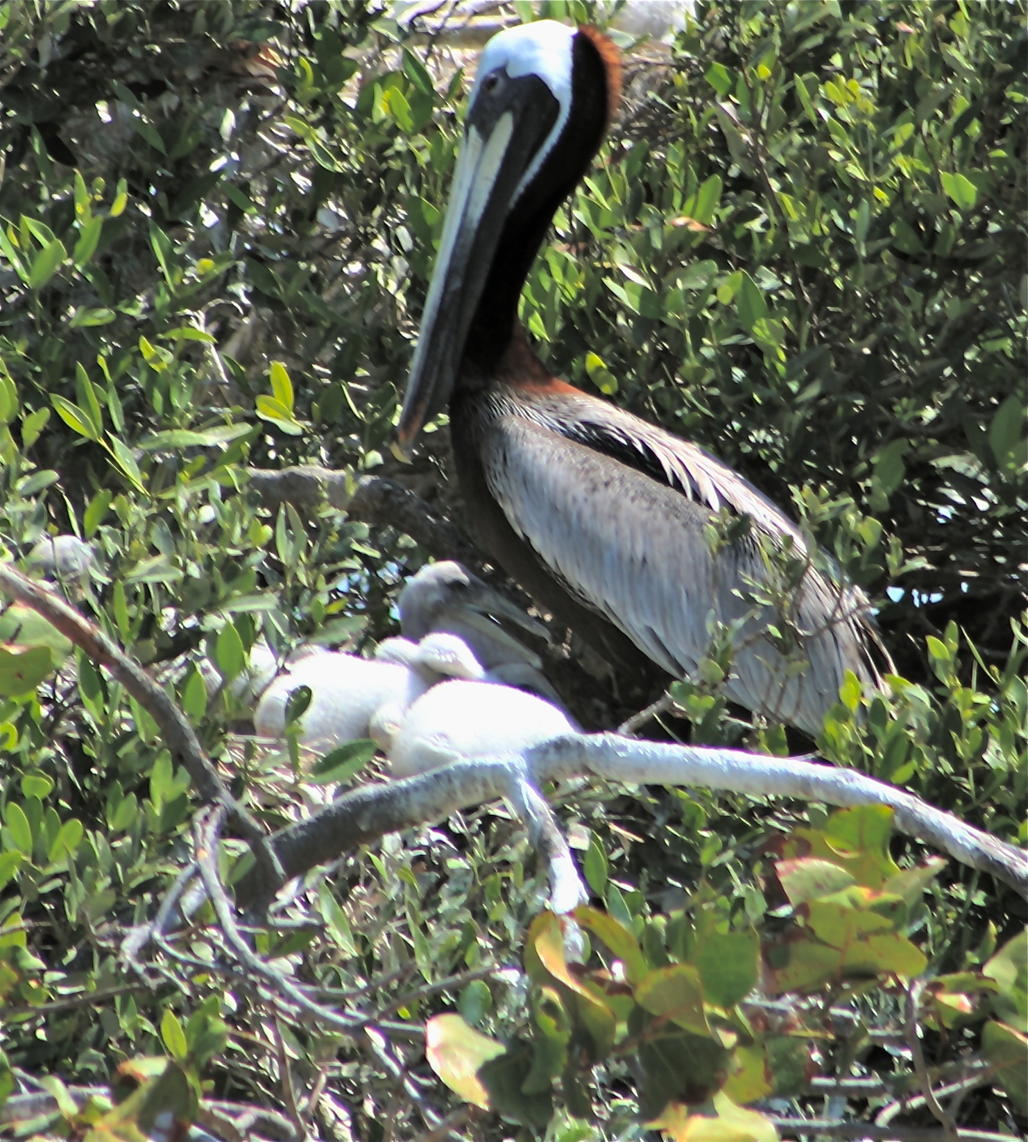
Bird Island is one of the most productive breeding grounds for more than 15 species of birds and a rookery/visiting grounds to even more species. The island is owned by the state of Florida and managed by Martin County. It is located 400 feet from the Town of Sewall’s Point. (Most photos by Greg Braun, Sustainable Ecosystems International, story below.)
Just over three years ago, I was going through I guess a kind of mid-life crisis where I really was questioning what I was doing with my life. When I couldn’t seem to get it together, I decided to spend some time going back to “my roots,” to the things that made me happy as a kid. I called up family friend Nancy Beaver of Sunshine Wildlife Tours in Port Salerno, and asked her if I could volunteer on her boat a couple of times a week. She obliged, and slowly, I felt my passion for life return while being surrounded by the animals and birds in the St Lucie River/Indian River Lagoon. The highlight of every tour was “Bird Island,” located off my “very own” Sewall’s Point, as I was mayor of the town at the time.
I had seen the birds from far away, but to see the beautifully colored birds, especially their babies, through binoculars up close was incredible.
Bird Island, located in the Indian River Lagoon, just 400 feet off of the Sewall’s Point’s Archipelago is one of the most valuable nesting bird habitats along Florida’s east coast, really in all of Florida. Rarely are so many different kinds of birds in one location, breeding…
A wonder of nature, birds of all kinds fill the island, over 40 types visiting or roosting and at least 15 species of birds simultaneouly raising young. At any time of late fall through spring hundreds of birds sometimes over a thousand, some say more, fill the island.
Greg Braun, of Sustainable Ecosystems International, was hired by Martin County for avian monitoring September 2011 thorough August 2012 and he documented observing 240 pairs of birds of 15 species nesting including the Wood Stork; Brown Pelican; Double-crested Cormorant; Great Egret; Cattle Egret; Anhinga; Tri-colored Heron; Snowy Egret; Great Blue Heron; Litle Blue Heron; Black-crowned Night Heron; Great White Heron; Roseate Spoonbill; Black Vulture; Oystercatcher; and suspected White Ibis and a couple of invasive Egyptian Geese.
So why this island? There are plenty of others to choose from in the area. Maybe it is for protection? Maybe its the eastern sandbar that keeps boaters at bay and gives the chicks a place to practice swimming and flying and the older birds can just hang out? Maybe its the nearby western seagrasses with its rich production of fish.
Nobody really knows but obviously the birds like it. Originally Bird Island, more scientifically known as “MC-2” was created in the 1940s as a by-product of dredging the Atlantic Intracoastal Waterway, (Braun, Avian Monitoring). My mother, historian, Sandra Thurlow, says there are verbal accounts of birds nesting on the island since the 60s and 70s, but again nobody is really sure when it began…
Man’s involvement remains controversial with the removal of tall Australian Pines a few years back that the amazing Frigate Birds sat on, and then the building of a $600,000, 400 foot long rip-rap on the island’s northern side by Martin County to offset documented erosion. Now in the process is the Florida Wildlife Commission’s (FWC) possible creation of a CWA or Critical Wildlife Area so that trespassing onto or very near the island would be a crime.
Personally, I think the bird’s habitat should be very protected as the importance of the island is obvious and it is a rare thing. As far as the CRA status, the County is working through issues with local fishermen who use the area for bait catching, and other users of the area surrounding the island. I do hope some higher level of protection can be met.
Right now, signs surround the island in hopes of giving the birds the privacy they need to raise their chicks, but curious kayakers and others often go very close flushing the birds off their nest, with masses of crows waiting close by, putting the chicks at risk. Sun exposure can also kill the young chicks. People don’t mean to but they often do disturb the island.
Another common problem is fishing line. Nancy Beaver and the FWC when in the area often see birds entangled in monofilament caught in the mangroves. Many birds are taken to the Treasure Coast Wildlife Center and saved; but many more are euthanized due to emaciation.
Bird Island was definitely affected by last year’s putrid release water from Lake Okeechobee and the other canals as is visible in an aerial photograph included in this blog. During the releases, 85 percent of seagrasses died last summer according to Florida Oceanographic Society. The bird’s feeding was/is certainly affected by such loss.
In the end, I do believe everyone agrees that Bird Island is an amazing place. Let’s get along like the many birds do and protect it! And if you have not seen it, maybe put it on your list of things to do!
Army Corp of Engineers’ structure S-80 releases water from Lake Okeechobee into the the C-44 Canal that leads to the St Lucie River/S. Indian River Lagoon. (Photo Jacqui Thurlow-Lippisch, 2013.)
Today is what I consider the genesis of the Martin and St Lucie River movement, as last year, on this day, May 8th, 2013, the Army Corp of Engineers opened the gates of S-80 once again, but little did they know, this time things would never be the same….
Before we laud ourselves too much it is important to know our history and its not a fun one to study. Martin County and the C-44 Canal have a long history, in fact the canal, started in 1915 precedes Martin becoming a county which occurred in 1925. The City of Stuart though was incorporated in 1914, and it was their early leaders that supported the the building the C-44 canal.
Ironically most the early settlers wanted it, having no idea of its unintended consequences, and in 1915 even held a celebration when construction began by featuring the high school band and a gathering at Woodmen Hall in downtown Stuart.
According to historian Sandra Thurlow’s book Stuart on the St Lucie:
“The Stuart Times pleaded for a canal in its early issues in 1913. The Stuart Commercial Club pushed for the canal and clashed with BW Mulford and and other promoters of Salerno who insisted that the best route for the proposed ship and drainage canal from Lake Okeechobee would be one cut into the Manatee Pocket.”
The canal was an economic issue and people wanted jobs and trade brought to the area.
After the Hurricane of 1928 the canal was widened and deepened, and the situation really got worse. “Silt and chemicals entered the St Lucie/Indian River and diminished the once teeming fish population.” Again according to Sandra Thurlow, “because the the changes were gradual it took a while to notice that the abundance that had nourished the settlers and attracted the sports fishermen no longer existed.”
Hard to believe isn’t it? I have had some people tell me, “It’s better not to bring this up….” I disagree. Times change and values change. Our country is known for overcoming some of the most difficult of institutions such as slavery and women’s rights. Environmentalism is also a social issue. It is based on how one views the world, what is acceptable or not.
Today most Stuart and Martin/StLucie residents agree that it is no longer acceptable to have up to 9000 cubic feet per second of dirty, tainted Lake Okeechobee water released into our St Lucie River. In 2013 the releases from Lake Okeechobee tipped the scale for toxic algae blooms in the estuary, (FOS, Mark Perry). And it was well known from sampling that the South Florida Water Management District (SFWMD) knew toxic algae was being released into the estuary at S-80.
In the early 1900 and even through the 1970s, not that many many people lived in Martin County. Having grown up here, I can attest to that. But, that is not the case today. Releases that were simply “accepted” are now “unacceptable.” Unlike years ago, with today’s high population and health and safety issues that are the responsibility of the state, the releasing of toxic waters from outside our basin is an embarrassment and seems illegal.
1930 was the first year the Martin County Commission asked the ACOE to stop discharging and passionate people have been demanding such ever since. But at that time, there were not enough people to really have a voice and the general public was not screaming along side its leaders. Today we are are all on one page. Local elected officials and the public. And we also have tools that allow us to make our cause a state and national issue.
If history has shown anything at all it is that things do change. I believe we are the generation that is in the right place at the right time to finally cause the turn of history for the St Lucie River/Indian River Lagoon. Happy May 8th, 2014!
A baby screech owl sleeps in a tree the morning after its “big jump.” (Photo Jacqui Thurlow-Lippisch, 2014.)
Recently, I have had the most amazing experience as a family of screech owls decided to use the nesting box that is literally right outside my bedroom window.
My husband helped me put up the box. We live in Sewall’s Point one lot off the St Lucie River/Indian River Lagoon. Screech owls are common here but never did I dream of watching them so up close.
The family set up house about two months ago. The first owl I encounted was “Dad.” I noticed that every day, he was sitting in a vine growing in the strangler fig tree by our front door. At first, I did not know he was “dad,” but I soon figured this out. He was a funny little owl, standing about six inches, with crossed looking eyes and a flabbergasted expression like Jack Nicholson. I tried not to scare him but soon realized he was not afraid and I could take photos. I took them quickly and darted away, thanking him for living at my house.
After a few weeks, my husband Ed, who gets up much earlier than I do, told me he thought he had seen the little owl flying into the nesting box in the dim light of morning. Within a week or so, one day I heard soft chirping inside the box. At that point, I knew there must be a mate and chicks, as I had read that screech owls are monogamous. Amazing!
Within another week or so, one Sunday afternoon, the mom stuck her head out. She was much rounder than her counterpart and redder in color. She looked exasperated like the growing chicks were restless below her, pushing her up in the box.
Within a few days, she flew and joined her mate in the tree. In the evenings or mornings chicks soon started to emerge and then would pop back inside.
The mother and father owls sat silently with great patience for many days waiting for the baby owls to leave the box.
Ed and I could never figure out how many babies were there were. We thought two or three, as some seemed bigger or smaller, and had different faces, but really, they all kind of looked the same!
Then one evening, on a Friday, Ed wanted to go out to dinner and as he went upstairs to get ready, I heard, “Jacqui! A baby is out of the box!” Outside, I threw down the hose, water gushing, leaving my flip flops behind and ran up the stairs as fast as I could to see a fluffy owl sitting along the chair on the upstairs balcony just under the nesting box. It was as large, if not larger, than its parents!
I lay on the floor looking under the blinds and watched this baby owl decide to jump thirteen feet to the deck below. Incredible! I worried like a mother myself!
“Oh Ed, what if he gets hurt? What if he breaks a leg and we have to take him to the Treasure Coast Wildlife Hospital?”
“Why would you want to do that? ” asked Ed. You’re the one who aways says ‘let nature take its course’…”
“That’s not funny Ed, it’s just a baby…”
“Let’s go to dinner,” Ed replied.
I knew I was pushing it, but this was a once in lifetime opportunity.
“Oh, I can’t yet, I have to watch it jump! Look it’s moving its head in circles like a chicken! Look! Oh it just crashed into the railing! It got up! It’s trying to jump! Oh my gosh! Should I take it down myself….? ”
Silence….
So Ed sat at his computer as dusk fell and I lay on my stomach watching and praying for the baby owl and restraining myself from messing with Nature. I heard the mother and father calling and the baby owl inched closer to the edge of the balcony getting up his nerve, jumping high and then going low, sitting on a chair, walking the railing, flapping his little wings. And then finally, he looked down and just jumped!
“He jumped!” I screamed from the bedroom.
Ed came up the stairs, and we watched, in the dim light of evening the baby owl hop into the vine along side his parents. He had not hurt himself. He trusted his instincts and he succeeded.
Night came and the owls spoke to each other in a tongue I could not understand, but I knew it must be a proud day for those parents and for the baby owl too.
Ed and went to dinner, we toasted the baby owl, and all I talked the whole night was the power and faith, of being able to get up the nerve to jump, unafraid into one’s destiny…
North Fork of the St Lucie River is fed by Five and Ten Mile Creeks in St Lucie County. Once the glorious headwaters, they are today hardly recognizable.(Photo by Jacqui Thurlow-Lippisch, 2010)
Map, SLC, Ten and Five Mile Creeks are located in St Lucie County north of Midway Road.
Ernie Lyons wrote in the 1960s: “There was never anything more beautiful than a natural South Florida River, like the North and South Forks of the St Lucie…Their banks of cabbage palms and live oaks draped with Spanish moses and studded with crimson flowered air plants and delicate wild orchids were scenes of tropical wonder, reflected back from the mirror-like onyx surface of the water….”
A recent St Lucie County tourist publication goes back even further back: “Early Ten Mile Creek along with Five Mile Creek to the northeast form the headwaters of the North Fork of the St Lucie. These waters were originally comprised of a large area of interconnected march that eventually formed a creek. This marsh system in times of high water connected with the St Johns River, which flows north, allowing native peoples to travel many miles by canoe. These native peoples lived and flourished in this area 3000 to 750 years BC.”
Although the north fork and attached waters were awarded the “Florida Outstanding Waters” designation in the 1970s, by 1995 the Department of Environmental Protection published a report on pesticide contamination in the area: (http://www.dep.state.fl.us/southeast/ecosum/ecosums/tenmile_creek.pdf)
Today the area is most well known for “Ten Mile Creek,” the failed storm water treatment area built by the Army Corp of Engineers and the South Florida Water Management District (http://www.saj.usace.army.mil/Portals/44/docs/FactSheets/10Mile_FS_July2012_508.pdf) Thankfully after more than a decade, the agencies are moving forward on rectifying what they can of the project.
So what happened? How did this paradise die off? How did the “fresh water in the upper zones, furnishing some of the most marvelous sport fishing conceivable” pretty much disappear?
Again, I will quote Stuart News editor and environmentalist, Ernie Lyons: “Drainage canals mostly for agricultural purposes, cut the throats of the upper rivers. During periods of heavy rainfall, muddy waters gushed down and turned the formerly clear streams into a turbid, silted mess. During dry spells, gated dams held back the water for irrigation. The water table was lowered. Salt marched upstream, turning the formerly fresh waters brackish and eventually so salty that fresh water fish could not procreate.”
As we know, humankind changes his/her environment. Not only were the canals cut in the northern creeks, but Gilbert’s Bar/St Lucie Inlet was opened permanently (by hand) in 1892, allowing salt water permanently into what used to be a fresh water river….the St Lucie.
Somehow it seems we should be able to change things with out creating so much destruction. I have hope our children will…
A portion of the restored Kissimmee River. Note discolored and filled C-38 canal juxtaposed to winding restored, greener oxbows. (Photo Jacqui Thurlow-Lippisch, 2014).
Last week, on a hazy smoked filled afternoon, Ed and I flew over Lake Okeechobee and the once mighty Kissimmee River. There was the normal stress involved with me giving Ed directions and the fun of an adventure. It went something like this:
“Oh there it is, the Kissimmee’s opening to the lake, over there!”
I can’t fly north of “over there,” it’s off limits; it’s a near a bombing range or air force base…” says Ed, shooting me a serious glance.
“What a bombing range-air force base? You’re kidding, close to of some of the state’s richest wildlife habitat? How symbolic…”
Ed rolls his eyes, I can feel it. But he tries harder…
Somehow, Ed talks to Miami Air Traffic Conrol and we get lucky. It is a Sunday and we are allowed to fly over at least part of the area I wish to see.
On the way, we fly over the southwest area of the lake’s agricultural lands. The hand of humankind is reflected in organized, perfect sized boxes of agriculture and straight canals.
We veer off to the northwestern area of the Lake Okeechobee where earth and water meet; on this side of the lake the hand of the Creator still evident. Little specks of light blend together in a blinding symphony of light.
We near the area in Okeechobee County where the mouth of the once great Kissimmee meets Lake Okeechobee. The straightened canal looks out of place among the lush greenery and a small town is evident. There are people here. Flooding is an issue.
It is great seeing “it all” from above as I have never really been able to figure out on a map where the Kissimmee River restoration is happening. It starts about 20 miles north of the lake.
The Kissimmee river was once 103 miles of wildlife/fish filled meandering oxbows, but it was canalized to a depth of 30 feet as C-38 from 1962-71. This was part of the Army Corp of Engineers and the Central and South Florida “Flood Control Project” of 1954. The state had asked for help after two back to back hurricanes and wide spread flooding and destruction in 1945. The state got help but with untended consequences…
The Kissimmee River that once meandered south to Lake Okeechobee as part of a two mile wide flood plane now shot down to the lake with grave environmental effects that included the destruction of the estuaries, St Lucie/Indian River Lagoon and Caloosahatechee.
Since 1994, around 23 miles of the now 56 mile long canal, C-38, from Lake Kissimmee to Lake Okeechobee has been/is being backfilled and considered part of “the” most ambitious environmental restoration project in the world.
Recently, the ACOE and SFWMD have been in a dispute over the completion of the restoration project. The project is tremendously expensive requiring federal and state funding which has not come easy since 2008. The two agencies “cost share” in its completion. Word is they are “working things out…”
The long term goal is to continue the restoration of at least 20 miles more of the 56 miles of the canal.
In light of the dying Indian River Lagoon, it is important to see that restoration can be accomplished. Mother Nature is quick to rebound once given the chance.
The Kissimmee’s restoration is critical, as the polluted waters coming from Orlando south carry sediment, and urban and agricultural runoff into the lake. As we know, when the lake gets too full the water is diverted to the estuaries because the water is not presently allowed to flow south, as the EAA (Everglades Agricultural Area) is located there along with cities of people.
So we here along the St Lucie Indian River Lagoon, are fighting a two front war. One north and the other south of the lake. We are winning in the north because the ACOE and SFWMD recognized their/our mistakes, and have been working since 1994. We are also getting closer in the to finding a safe way to “move the water south…” CEPP (Central Everglades Planning Project) is not looking good right now, but the pressure is on, and even Tallahassee is saying “move the water south!”
We must have inspiration or we will never complete our goal of saving the estuaries. The Kissimmee River is a place to look and find hope.
2014 Google Earth map of restored area of Kissimmee River.
1883 topographical map. Sheet #1652: The “South End of Indian River.” Surveyor, Chief of Party, B.H. Colonna.
Imagine setting eyes on the surrounding lands of the beautiful St Lucie River/Indian River Lagoon, in virgin form, the year 1883. You are a surveyor, and your job is to create a map, a map showing the topography of the area. It’s a jungle, the insects are singing, animal life is everywhere, there are even remnants of the Seminole Indians that appear and disappear cutting back the palmettos so they can see you. There is venison, bear and many kinds of delicious fish. But there are also seven foot rattle snakes and mosquitoes in the saw grass ponds that will cover your face and make you jump in the river! Nonetheless, this Eden is a place of beauty.
How did I come upon this survey? Surveyor, Mr. Chappy Young, GCY Inc. of Palm City, has known my family for many years and recently sent me a copy of this original hand written part of the 1883 topographical survey completed by Chief B.H. Colonna and his men. What an incredible thing to read, a first hand account of this area from over 120 years ago! It is a treasure.
I will choose some highlights to quote and some I will summarize. My excerpts come off a bit choppy but the accounts are still incredible.
The twelve page report is hand written in cursive and documents the “East Coast of Florida from Eden Post Office, or Richards, southward, to Peck’s Lake, including the St Lucie River.”
It begins:
“On the west shore of the Indian River the ground rises from five to eighty feet above the level of ordinary height of the water in Indian River, the higher ridges give quite a pretty landfall when seen from four or five miles off shore, quite outcropping the land, and found between Indian River and the ocean.”
Colonna talks of standing on the highest point of the west side of the Indian River, “Blue Hill,” and “looking westward to see a number of parallel ridges of sand, with intervening saw grass ponds;” he describes the yellowish-white Conchina sands and the roads as marine conglomerates.
“The vegetation is thick,” he writes, and “the many hammocks rise above the flatlands recognized by their palmettos (sable palms), mastics, rubber trees, live oaks, iron wood and crab-wood along with a great variety of other trees.”
The St Lucie and Indian River Lagoon are filled with life. He describes a great number of coots and ducks on the rivers; as well as quail, partridge, and wild turkeys in the surrounding woods, and many small birds, just about everywhere, daring about. The waters are filled with luxuriant eel grass the favorite food of the manatee which also is abundant.
He talks of giant sawgrass with blades in the ponds and fresh waters three to ten feet long and very sharp. And further west soft, sweet, moist grasses attracting deer.
You can image, Chief Colonna was camping for many months, maybe years with his team; so he was able to document watching river waters rise 2-3 feet during rainy season, and the lands being inches deep/sometimes feet deep, in water…
In 1883, the year this survey was taken, the inlet, Gilbert’s Bar, next to today’s Sailfish Point, was closed. He explains, mentioning fish on the reef that I have never heard of…
“The old Gilbert’s Bar entrance, now closed, is shown on the sheet. Whenever the salt and fresh waters meet, the mangrove flourishes and such has been the case at Gilbert’s Bar. Once fine oysters grew there and all kinds of fish belonging in these waters were abundant, but sine the inlet closed the oysters have died and the fish are gone except a few bass and catfish. Just outside and along the old Gilbert’s Bar, (Conchina Reef). There are lots of fish, Barracuda, Pompins, Blue fish, Cavallis, Green Turtles, Mullet, Sea Bass, and a beautiful fish, much resembling our spanish mackerel, but it has more beautiful colors and is very tame. Trolling there I have seen them take the hook and bound 5-10 feet clear of the water. I had thought the blue-fish game, and the taking of the fins for sport, but one of these beauties far exceeds anything I ever saw for pluck, rapidity of motion and beauty of form and color…”
According to Colonna, the “House of Refuge was the best dwelling on the sheet,” and “Dr Baker’s house (in today’s Indialucie) was the only place that looked like a home.” This is interesting to me because I grew up there. His account of my former playground:
“In this area the rattle snakes are the largest I have ever seen being from 6-7 feet” but there are not many; alligators are no longer numerous and have become shy; but raccoons and opossums are so thick it is impossible to raise fowl; “wild cats are 4′ 6″ from tip to tip,” and Black Bears come in June across the lands to comb the beaches for turtle eggs…”
I think I would have had fun living in the area in 1883, but I would have worn boots for sure!
And now the grand finale. On the final page of the handwritten piece, Chief Surveyor, Colonna proclaims:
“The prettiest land on the sheet is the peninsula laying between the St Lucie River and Indian River, from Mount Pleasant south, to the the point. It is high hammock land with Cochina foundation and covered by a heavy growth of Hard Wood and underbrush with now and then a pine. This country had quite a population in it once, just before the Seminole outbreak and for a times after it, the settles had oranges, lemons, and limes, some of the old trees are sill to be found in the vicinity of Eden P.O. and the limes are very fine but the oranges are bitter and the lemons not bearing..”
(Mount Pleasant is Francis Langford’s former high river property.)
So congratulations to Sewall’s Point, the “prettiest” piece of land surveyed in 1883 and still known for her beauty today. All of our area around the Indian River Lagoon and stretching westward is beautiful, a changed but modern Eden. Let’s protect it for the next 120 years.
Canals C-23, C-24 and C-25 in St Lucie County were built in the 50s and 60s and are all connected. C-23 and C-24 release into the north fork of the St Lucie River leading to the S. Indian River Lagoon, but C-25 releases straight into the southern central Indian River Lagoon near Taylor Creek, close to the Fort Pierce Inlet. These canals were built as part of the Central and South Florida Project of the 1940s that came into existence after a very large flood of central and south Florida. (Photo, Jacqui Thurlow Lippisch, 2013)
One of the things that is hardest for me to comprehend is that my ancestors worked as hard, if not harder, to get the water off the land as I am, trying to keep in on…
According to an article shared by my mother, historian Sandra Thurlow, by Charles S. Miley a newspaper man in Ft Pierce, “prior to the 1920s floods were a common occurrence in the area particularly in the back-coutry.”
The article discusses how a demand for drainage began to develop among land owners as the growing of pineapples was no longer profitable and the people turned to citrus. In 1915 citizens in the area of Ft Pierce “held court” forming the North St Lucie River Drainage District. The headline in the News Tribune paper of 1921 read: ” Drainage of 75,000 Ares of Rich Land Now Under Way.”
I can just see it, “Sam, I think it’s time to form a flood district and utilize our lands.” Go forward just shy of 100 years and the conversation is : “Joe, I think it’s time we get the Army Corp to stop dumping this lousy water into the St Lucie River, ruining my riverfront property values.”
The North St Lucie River Water Control District is still in place today and was created, as all drainage districts of its time, under the provisions of Chapter 298, Florida Statutes, commonly referred to as the “General Drainage Law of Florida.” Today the NSLRWCD falls under the authority of the South Florida Water Management District that historically began really as the Central and South Florida Project, C&SFP.
In 1945 there was massive flooding throughout central and south Florida so the state and its residents called for federal assistance. Sound familiar? It may if you recall that the Hurricane of 1928 caused an even more extreme reaction and the Herbert Hoover Dike was built around Lake Okeechobee by the Army Corp of Engineers. Thus our federal partnerships today. The one that we complain about all the time…Ironic, isn’t it?
The green area is the NSLRWCD’s boundaries; the orange are is the Fort Pierce Farms Drainage District, since 1976 under the South Florida Water Management District.
So, I drifted a bit, but I was talking about the Central and South Florida Project. This large project was formed after the great flood of the 1940s and three huge canals were built during the 50s and 60s as part of this plan: C-23, C-24 and C-25. I drove over them for years with my parents as a kid and had no idea what they really were, I never learned about them in school, and I was 40 years old before I decided I needed to figure them out…
Map of canals system, Matin/St Lucie Counties.
I have not even mentioned the C-44 also known as the “St Lucie Canal” that is further south. This canal drains the basin lands around it as well as being a dumping ground for “overflow waters” of Lake Okeechobee.
The South Florida Water Management’s web site says that after C-23, and C-24 were built, the north fork of the St Lucie River drained lands approximately four times its natural drainage size! That is not even counting C-44 and Lake Okeechobee. Oh, and by the way in 1892 we opened the St Lucie Inlet permanently too.
We are living a world very different than Mother Nature created. From what I’m told she’s moody and a bit irritated. I think I’ll keep working on getting her some of her water back!