Monthly Archives: June 2018

ACOE Halts Lake O Discharges to St Lucie for 9 Days, SLR/IRL

At Port Mayaca 6-24-18 JTL/EL

Video link LTC Reynold’s intro comments/presentation: (http://www.youtube.com/watch?v=GVMsIG5qEYE)

Video link LTC Reynolds’ announcement, Rivers Coalition: (http://www.youtube.com/watch?v=J4Wb0CyS6GI)

6-28-18

Today, at a Rivers Coalition meeting, Army Corp of Engineers, Lieutenant Colonel Jennifer A. Reynolds, announced unexpected news: the ACOE will stop discharging to the St Lucie River for 9 days and then resume. They have been releasing from S-308 for four days since a past weekend pause…

This halting, considering it appears to be at least partially a response to an almost completely cyanobacteria filled Lake Okeechobee, and though temporary, is a significant federal decision in the documentation of toxic/algae/St Lucie issues.

NOAA Copernicus Sentinel-3 EUMETSAT[/capti
ACOE NEWS RELEASE 6-28-18: http://www.saj.usace.army.mil/Media/News-Releases/Article/1562727/corps-to-temporarily-reduce-flows-from-lake-okeechobee/

Video link Rob Lord, Martin Health Systems: (http://www.youtube.com/watch?v=lzfmOWWDU4k)

The meeting began with Martin Health CEO, Rob Lord discussing health concerns of contact with blue-green algae, and ended with LTC Jennifer Reynolds showing herself to be among other things, a gifted communicator. Please watch the videos for details of this day.

The Jacksonville District of the ACOE will be announcing its next three-year positions for Colonel and Lieutenant Colonel in the coming weeks or months. This cycle of short-lived leadership makes developing lasting relationships  and, thus change, indeed almost impossible. But days like today, give one hope.

Thank you LTC Reynolds for your time here, it would be so helpful if you could stay on longer. http://www.saj.usace.army.mil/About/Leadership/Bio-Article-View/Article/600382/lieutenant-colonel-jennifer-a-reynolds/

Links:

TCPalm reporter, Ed Killer, https://www.tcpalm.com/story/news/local/indian-river-lagoon/health/2018/06/28/lake-okeechobee-discharges-stop-nine-days-then-resume/741958002/

Rivers Coalition: http://riverscoalition.org

Mark Perry, Florida Oceanographic, & RC Leadership Team leads meeting
The River Kidz give a report on their trip this week to Washington DC participating in “Lagoon Day,” sponsored by Congressman Brain Mast. Nine young people traveled and met with multiple leaders including: Congressmen Mast, Graves, Shuster, ACOE Col. Kirk, & Senators Nelson and Rubio.
Todd Weissing speaks
Allie Preston ask a question
LTC Reynolds

Masses of Algae Pressing the Gates; Will ACOE Discharge Tomorrow? SLR/IRL

6-24-18, (Sunday)

I am posting this, not because I want to but because I have to. I much rather be enjoying the day instead of once again sitting at my computer. But time is of the essence.

This morning I read a comment by TcPalm reporter, Ed Killer, on Facebook stating the ACOE’s pulse release schedule for the St Lucie River.

Ed KillerThe Corps gave me this today

Sat- 0
Sun- 0
Mon- 1270 cfs
Tues- 2000
Wed- 2100
Thu- 1650

If this is true, and with Ed Killer posting, I believe it is, the ACOE will start releasing again Monday, 6-25-18. I did not know this until I read his post.

Today, my husband Ed and I were flying other people over Florida as usual, and during our flight I took this video expecting maybe some algae in C-44 but instead also found the gigantic bloom against the gates of S-308 in Lake Okeechobee leading into C-44/SLR.

So I wrote on Facebook:

I am so over this, but cannot fail to report. According to Ed Killer ACOE will start discharging from Lake O tomorrow in spite of Governor’s Emergency Order. Look at this algae mess waiting at gates of Port Mayaca. Write ACOE’s LTC Jennifer Reynolds and politely ask for ACOE to wait and to have DEP test again: jennifer.a.reynolds@usace.army.mil (JTL-S-308 video taken 6-24-15 at 12pm) #toxic2018

As Monday is tomorrow, and I fly to DC with the River Kidz tomorrow, I am posting this now. I truly believe considering the circumstances, that the ACOE should refrain from discharging at S-308 or S-80. And the state’s FDEP (Florida Department of Environmental Protection) should have this water tested, again, as bloom has changed.

To just dump this on the people of Martin County along the St Lucie River is a crime.

Respectfully,

Jacqui

PLEASE WATCH THE VIDEO

The recognizable shape of S-308 the entrance to C-44 and the SLR. Lake O’s connection to the river—obvious massive algae bloom at gates.
Bloom as satellites show is throughout and scattered in lake. This shot is looking more towards middle of lake in southern area.

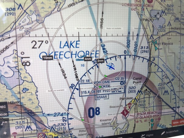
Entrance to Caloosahatchee on west side of lake and near Clewiston Bloom is all through lake.

The Politics of Algae, “God Save the Queen,” SLR/IRL

Present Lake O algae bloom, as first publicly reported June 2nd, has grown to approximately 253 square miles. Although larger, this bloom appears less dense from space than either the June 24th or July 2nd 2016 images –  that measured approximately 239 square miles. Image courtesy of Todd Thurlow, 6-20-18. See other satellite images here: http://www.thurlowpa.com/LakeOImagery/

The algae in Lake Okeechobee is Mother Nature’s political checkmate, the time in chess in which the King cannot escape…

Thank you to Department of Environmental Protection Secretary, Noah Valenstein, whose Emergency Order directed by Governor Rick Scott, announced yesterday,  will implement an array of new actions to move more clean water south into the conservation areas and away from the estuaries.

f=”https://jacquithurlowlippisch.com/wp-content/uploads/2015/01/photo7.jpg”> SFWMD’s Home Page for Sending Water South. (http://sfwmd.maps.arcgis.com/apps/MapTour/index.html?appid=a9072c94b5c144d8a8af14996ce23bca&webmap=d8e767997b0d494494243ffbc7f6f861)[/capt
Make no mistake about it, this order happened due to Mother Nature’s “check.” The algae in Lake Okeechobee is exploding at record speed – see above image from yesterday, 6-20-18.

Sending algae that is potentially toxic to the communities of the St Lucie River and the Caloosahatchee is political suicide even for the Army Corp, an entity that is basically untouchable, like a King.

But since the state is legally in charge of water quality, not the Corp, the order comes from Florida’s Executive Branch as they, became aware of the seriousness of the problem. The Corp has reported they were lessening discharge amount anyway, however, they did not recognize the health threat of the algae…

Nobody wants to purposefully poison the estuaries, but the Federal Government and the State of Florida does when algae, potentially toxic, is sent through gates connected to Lake Okeechobee. We are all in a difficult situation, a chess game whose rules are outdated and were created years ago…

And even if there is “limited capacity” to move water south, it can be done. “Something” is “everything” in this water game of chess. We must take what we can get, check the King, and then go back for more – the goal to close the gates forever. “Checkmate.”

In my opinion, this emergency order is a real move that will send more water south and help reinforce a “send water south,” political culture that all Florida must embrace!

God Save the Queen, our one and only, “Mother-Nature.”

(I have updated this post due to spelling errors, etc.. 6-24-18. Sorry. I, like everyone, am exhausted. JTL)

LINKS: 

[/caption]June 21, 2018 PRESS RELEASE SFWMD

SFWMD Takes Additional Action to Send Water South Under Direction of Gov. Rick Scott; Issuance of Emergency Order
~District measures underway to help lower water levels, reduce need for Lake Okeechobee releases to northern estuaries: http://campaign.r20.constantcontact.com/render?m=1117910826311&ca=88c832d4-c24e-4928-ae9d-96e80ad4ee21

6-20-18, Politico, reporter Bruce Ritchie, Lake O Discharges Raise Ire From DC to Tallahassee: https://www.politico.com/states/florida/story/2018/06/20/lake-okeechobee-discharges-raises-ire-from-dc-to-tallahassee-480899
Checkmate:https://en.wikipedia.org/wiki/Checkmate

6-20-10 Palm Beach Post Associated Press: https://www.palmbeachpost.com/news/local/florida-gov-rick-scott-urges-lake-discharges-sent-south/EWNzmsDxs2oBjnuwAqnRKM/

6-20-18: Press Release Office of Governor Rick Scott.: https://www.flgov.com/2018/06/20/gov-scott-directs-dep-to-take-steps-to-curb-potential-algae-blooms/

6-21-18 Col Jason Kirk, Viewpoint Lake Okeechobee,Editorial, Sun Sentinel, http://www.sun-sentinel.com/opinion/commentary/fl-op-viewpoint-lake-okeechobee-army-corps-20180620-story.html

6-23-18 Ed Killer, Did Rick Scott Save Summer? TCPALM: https://www.tcpalm.com/story/sports/2018/06/23/campaign-strategy-doing-right-thing-you-judge/727278002/

Algae Pouring into St Lucie; Shut the Locks, please! SLR/IRL

Taken this morning, 6-19-18, at St Lucie Locks and Dam, Mr. Greg Langowski, Regional Director for U.S. Senator Marco Rubio, has perfectly documented by video what is happening….

~The algae from Lake Okeechobee, and whatever else is now in the C-44 canal since the ACOE started discharging from Lake Okeechobee on June 1st, is clearly, – like an endless line of green ooze – getting sucked into the backside gates at St Lucie Locks and Dam, only to be spit in aerated form out the other side into the St Lucie River – where it will later re-congeal possibly into toxic gatherings.

Talk about throwing your trash over the fence….

Thank you Greg for this video, and hopefully the ACOE, The Florida Department of Environmental Protection, the SFWMD, and the Department of Water Quality and Best Management Practices of the Department of Agriculture will see and then visit themselves.

Shut the gates please!

#toxic2018

“Cockpit With a View,” Explosive Algae Bloom in Lake O, SRL/IRL

The pilots, our “Eyes in the Sky”- like satellites – are the key to “seeing” the extent of the algae problem in Lake Okeechobee, and provide a clear cockpit-view showing how algae gets into our St Lucie River.

I thank all of the pilots, east coast, west coast who have recently shared their cockpit-views.

Today’s photos are from pilot Steve Schimming who sat right seat, at about 1500 feet,  during Ed’s fly over of Lake O on Saturday when the two men were on their way back from Venice mid morning where they had gone to meet other pilot friends.

This enormous bloom, 102 square miles approximately, was reported, by me, to the Florida Department of Environmental Protection the same day. Hopefully, they are testing it in multiple locations. Although the ACOE holds the power to decide when to discharge from Lake O, it is DEP in coordination with the SFWMD, and the Water Quality Dept. (Best Management Practices) of the Dept Agriculture, that is in charge/responsible for water quality for Florida.

To report an algae bloom: https://floridadep.gov/dear/algal-bloom

Thank you Steve for sharing what you saw.

Almost like being there…

Steve Schimming, 6-16-18, Lake Okeechobee

___________________________________________________________________________

Ed Lippisch photo same day, same flight:

Ed Lippisch 6-16-18. Lake O algae bloom

For more photos go to this link: https://jacquithurlowlippisch.com/2018/06/16/real-time-eye-in-the-sky-of-102-sq-mi-lake-o-algae-bloom-6-16-18/

Sentinel Satellite image 6-15-18

Approximate size of bloom as seen from Sentinel satellite. See link to most recent satellite images made public and easy to find, by Todd Thurlow:http://www.thurlowpa.com/LakeOImagery/

#toxic2018

Real-Time Eye in the Sky of 102 sq.mi. Lake O Algae Bloom, 6-16-18

Things are happening almost in real-time today. My brother, Todd, sent me the L7 and Sentinel satellite images from yesterday revealing an approximate 102 square mile bloom in Lake Okeechobee.

I, in turn, wrote a blog post and sent the image to my husband, Ed Lippisch, who had flown across to west coast of Florida this morning.

Not too long after sending Ed that image, I look at my phone and it says “shared” photos from Ed, so I start looking at them. They are of the bloom in L.O. – over the broad area where the satellites had detected algae.

The phone rings, it’s Ed, he says” I just landed in Stuart.” I reply, “Great photos. Horrible. Thanks.”

He says: “Jacqui it was unbelievable. Very large bloom, it ran above Port Mayaca to about the southern shore of the lake and westerly. Very much like the satellite image you sent me, but even further north…”

So here are Ed’s unedited photos taken and then sent to me at 1:14pm, 6-16-18. Today.

#toxic2018

102 Sq. Mile Algae Bloom in Lake Okeechobee, 6-16-18

AlgaeBloom06-15-2018SWIR, Todd Thurlow

I could never do what I do without the people who help me. My husband, his pilot friends, the everyday people sending me “toxic-algae” imagery, the River Warriors community, and when it comes to striking the bull’s-eye, my science-studied-lawyer, little brother, Todd.

Just hours ago, Todd forwarded these images from satellites, Landsat 7, and Sentinel 2, clearly showing a large algae bloom photographed yesterday in Lake Okeechobee. 102 square-miles of it!

So Florida state agencies, and others…

…Do not tell me the algae comes from our river. It does not. We have been through this before….

The algae, that can become toxic, and maybe already is, starts in, and comes from the crock-pot of Lake Okeechobee. The Army Corp of Engineers should stop discharging right now.  Right when the Colonel sees these images. And these images have been seen, because NASA makes these images available to the Corp.

When a satellite image like this is made public, it cannot be ignored.

The ACOE should close the gates of S-308 until DEP has tested all edges of this large bloom. And work for never discharging when there is an algae bloom in Lake Okeechobee.

Stop the discharges from Lake Okeechobee!

LE07_L1TP_015041_20180614_20180614_01_RT-crop
Sentinel-2 L1C from 2018-06-15
Sentinel-2 L1C SWIR from 2018-06-15
Sentinel-2 L1C NDVI from 2018-06-15
Sentinel-2 L1C SWIR crop from 2018-
Sentinel-2 L1C NDVI crop from 2018-06-15

See this link of Todd’s for site with more satellite imagery: http://www.thurlowpa.com/LakeOImagery/

#toxic2018

Brian Mast, Even More than a Congressman of His Word, SLR/IRL

It takes a lot for me to trust a politician, probably because at times, I’ve been one myself…

In 2016, when I was running for District 1, Martin County Commissioner, I met Brian Mast. We were both standing on the side of Martin Luther King Boulevard,  with our teams, holding signs in near 100 degree heat and off the chart humidity. There is always time to wipe the sweat off your brow and talk, when no cars are driving by…

Of course, Brian is a striking person, no matter the case, but when he told me the St Lucie River’s health would one of his priorities, although pleased, ~because I had heard that many times only to lead to disappointment, I was doubtful. Only Senator Joe Negron had ever won my full loyalty for his commitment to the river.

Well, by tremendous fate, Joe Negron’s legacy is being pushed, most outstandingly, now by Congressman Brain Mast. Brain’s consistent record for the river, since being elected in 2016, cannot be matched congressionally by anyone else in office at this time.

His two recent letters to the Honorable R.O. James, Assistant Secretary of the Army on June 7th, and yesterday’s letter, dated June 14th, 2018, to LTG Todd Seminole, Commander General of the US ACOE, are unparalleled in direct, passionate, and respectful communication regarding the damaging algae releases from Lake Okeechobee to the northern estuaries, These are game-changer letters, that will be documented, and referenced in the archives of Washington DC building our case for years to come.

I commend Congressman Mast; I thank him for not only keeping his word, but exceeding  expectations. He is more than a soldier of his word, he is am American, and a St Lucie River hero. And he must be reelected.

Please read both letters below.

JTL

Brain Mast’s website: https://mast.house.gov

Meeting with C. Mast with EF in April 2018
Mast’s War Board for the SLR

Toxic Algae 101, Watching it Turn Toxic, SLR/IRL

St Lucie River looking across from Central Marine to Martin Health.

Mary Radabaugh called me this morning.

“Jacqui, get dressed and come on over here to Central Marine! It’s happening again, and this time there are logs, algae logs. I have never seen this before.”

since May 23rd, Mary and I had been exchanging photos of the water in the St Lucie River at the marina she and her husband have managed for many years. The marina that brought national toxic algae coverage in 2016. The marina that the SFWMD and DEP did core samples of river bottom in 2005, but have been quiet since. The marina that is the ground zero of zeros…

So I got dressed and headed over.

The waters have slowly been changing, worsening since the C-44 basin waters opened into the river  about March 15th. And Mary has documented this change on her Facebook page. After June 1st, when the ACOE opened S308 to discharges of Lake Okeechobee, things have sped-up and are starting to crescendo.

Only three days ago the waters of the St Lucie River were primarily a dark cloudy coffee brown sometimes with little specs. Then as winds and tides push the specks and foam in the river into the pocket of the marina, the now green specks of particulate start to organize. It is incredible to see that just from yesterday, to today, the algae has bloomed in bright fluorescent green slicks. In 2016, this happened all over the river, primarily in marinas, coves, along shorelines, against dock pilings and any other place the forever thickening algae would get “hung up.”

It is happening now too, but not as extreme. Yet.

This all happens because over the past 100 years the St Lucie River’s basin has been expanded tremendously, erroneously, taking on developed-land’s, and agricultural canal water (C-44, C-23, C-24) that pollutes and turns the brackish estuary fresh. Once the canals have almost killed the river, then the ACOE opens the gates of Lake Okeechobee without even checking the water quality from the SFWMD, or better yet, the Department of Environmental Protection (DEP). Just let ‘er roar!

This time, as was the case in 2016, an algae bloom in the lake is being transferred into the river through C-44. This is totally obvious with arial photography. The blooms start in the lake.

But since the river is now fresh, from all the canal  water, the microcystis  algae coming and once living in Lake O can live here too, and bloom toxic…

That the federal and state governments do this to their own people is mind-boggling. I know there are many water bodies around the county with algae issues, but we are certainly the only place in America where the government is knowingly dumping it on to a community of people.

There have been many opportunities over the years to fix the situation, but no, pure crises of the past few years is necessary before considering a fix….yes and thank God the EAA Reservoir is on the horizon. We must hold fast!

Today, I am sharing the photos of the Central Marina algae and its blooming.

Tomorrow  we shall see what else it brings….this algae has not been tested yet, but one thing is for sure, if history repeats itself, it surely will be toxic.

In closing, be sure too to watch the poor manatee eating the algae off the seawall. Having survived millions of years as a species, he or she certainly deserves better.

TIMELINE TWO DAYS

Tuesday, June 12, 2018 7:58 AM

By afternoon it was swirling into designs.

Tuesday, June 12, 2018 2:59PM

And then by today, it was filling in those shapes with fluorescent green.

Wednesday, June 13, 2018, 8:30 AM

Wednesday, 6-13-18, 2:02PM

#toxic2018

Eyes in the Sky for Algae, SLR/IRL

S-308 at Lake O
Overlook Drive, Stuart, FL

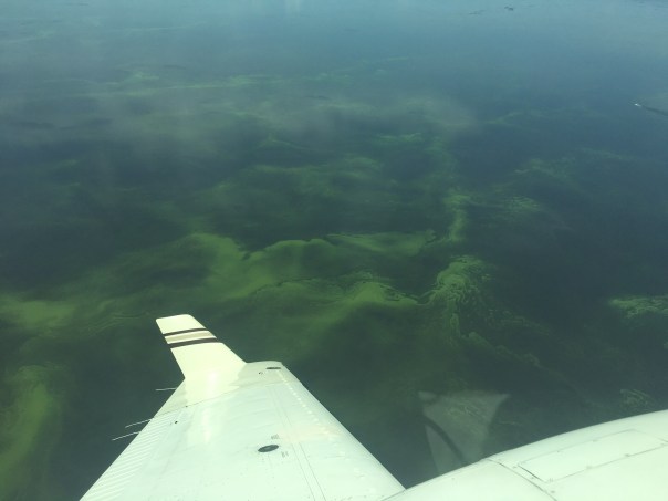
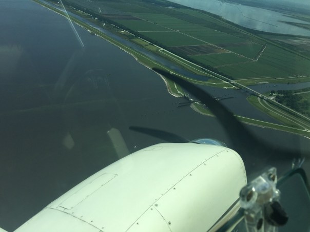
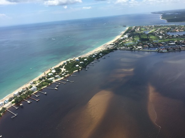
Thank you to pilot Ryan Moran for taking these aerials of the growing algae situation in the St Lucie River on 6-13-18.

His words:
“Not good news from today’s flight. Algae in Stuart, throughout the canal, and a very large bloom in the lake just outside the port. To add insult to injury, the locks are open and flowing. The pictures really do not do it justice.” Ryan

See all of Ryan’s photos here: https://l.facebook.com/l.php?u=https%3A%2F%2Fphotos.app.goo.gl%2FviURUDvk6WEXY7ZV7&h=ATPyNr0IvIgxDNJZUEVGFrDaPxRyLhLlbl4jPRvUADwzJv7mIScetFVKMCqUILxiS64OwS_-pwH4_BfH91nK_rqE5Qm-Y__8J0l_jyVZw9K2nLSmkORj3ANkgZaGt_oVmsk1t5M

Also, thank you to pilot Dave Stone for taking this photo yesterday of the Caloosahatchee plume in the Gulf of Mexico at 5500 feet.

This morning we are out with pilot Ron Rowers and my husband Ed Lippisch for today’s documentation of our Federal Government’s discharging of algae laden waters from Lake Okeechobee, often becoming toxic algae, into our estuary, at the injury of our economy, wildlife, and the tax paying residents of Martin County, not to mention the kid that would like to go fishing over summer break.


Report Your Algae Sighting to DEP, Overwhelm Them, SLR/IRL

I, as many, have seen and received multiple algae reports via Facebook, text, and through the tremendous reporting of Tyler Treadway of  the Stuart News. Now, I am encouraging everyone to take the time, and it doesn’t take much, to report their algae sightings in the St Lucie River/Indian River Lagoon to the Florida Department of Environmental Protection, (DEP).

It was Mike Connor who reminded me to do this, after my husband Ed accidentally spotted the algae lines by plane off Port Mayaca ~in Lake Okeechobee~ on June 2nd, the day after the ACOE started discharging.

At first I thought, “I’m too busy for that…” and then I realized of course I need to report to DEP because then the state is obligated to document and to test it for toxcidity.

Better yet, if everyone who is reporting via social media and text called DEP, there would be so many test sites for DEP to test, it would exhaust their resources.

Oh well…

Since our resources are gone, this is only fair.

As they say: “All is fair in love in war.”

Please report algae  sightings; see link below.

If you can’t figure it out this unclear website, call the Governor’s office: 850-488-7146 or Noah Valenstein the head of DEP: 850-245-2118.

Jacqui

https://depnewsroom.wordpress.com/south-florida-algal-bloom-monitoring-and-response/

Off of Overlook Drive near downtown Stuart. A beautiful location, an area Ed and I considered building on.

Liz Dunn shared 6-9-18 just south of Martin Health System.

Satellite Images of Lake O, What Do They Reveal? SLR/ IRL 6-7-18

Since the ACOE and SFWMD have yet to develop public satellite imagery of algal bloom development in Lake Okeechobee with NOAA during rainy season, I go to my brother Todd. Ever since we were kids, he’s loved science and technology.

I have been bugging him lately for a satellite image…

6-4-18, Jacqui : Todd do you know when last high-resolution satellite photograph was taken of lake o and how to access this photo? Thank you. 

6-4-18 Todd: Should have been a Landsat 8 image on 5/21 but it is not available for some reason. The Landsat 7 image from 5/29 is so bad because of the broken instrument that is not usable. Preview here, I would have to “order” high res but not worth it.

6-5-18 Jacqui : Thanks Todd

6-6-18, Todd: Hey Jac, the European sentinel-2 satellite took a good image yesterday. I will post it to my page tonight and add sentinel to the Landsat folder. It doesn’t show anything though. The sentinel-3 satellite took an interesting chlorophyll wavelength shot showing returns in the southern lake. However, it doesn’t seem terribly accurate because the returns over time have been all over the place. I will have to study more up on those types of images.

Sentinel-2 L1C, SWIR on 2018-06-05
Sentinel-2 L1C, True color on 2018-06-05

6-6-18, Jacqui: Well thanks Todd, thankfully that must mean at least for these images the algae is not so much that it’s visible to the satellite in space but we know some is there from 1st hand. This is good news for now. Can we keep getting images? Why ACOE and SFWMD don’t have and report on regularly is ridiculous.

6-6-18, Todd: …..

6-7-18 Jacqui: Hey Todd, the Terra image that is in today do you think that is algae or a cloud east of FPL Pond? Know hard to tell w/lower res.

Todd and I will keep you posted.

For more, go to Todd’s website, look for Firm Favorites; St Lucie River Discharges;  Latest Lake O Satellite Imagery:http://www.thurlowpa.com

Documenting the Discharges, June 2018, SLR/IRL

When the St Lucie River/Indian River Lagoon start to deteriorate due to discharges, things start going downhill fast. And when my husband Ed and I start taking and sharing aerial photos, my world becomes a bit chaotic.

Sometimes there are days of hundreds of photos to look through, and knowing the importance of getting them out immediately, choices have to be made. Facebook is a better medium than my blog for real-time info as it takes less time, but my blog is better for historic documentation as it is “permanent.”

So today I am sharing more of Ed’s photos from 6-5-18, and some you may have already seen. Mind you, after heavy rains, stormwater has been pouring in from many canals but, always, like clockwork, after the ACOE starts discharging from Lake Okeechobee, the river looks not just cloudy-coffee brown, but contaminated.

The ACOE started discharging from Lake Okeechobee on  6-1-18, and as most of you know, now, there are not only algae blooms spotted in the lake, as Ed accidentally found on 6-2-18, and others also documented, but also in the St Lucie River. More than likely, there will be more and more  algae bloom popping up as the Lake O water makes its way down the estuary, over the tip of Sewall’s Point, towards the St Lucie Inlet. Algae floating down the river is disgusting enough, but toxicity is the real question…

Ed and I will take and share more aerials  in the future, to document the algae blooms should they explode, but until then, here are some photographs from 6-5-18 that I had not yet archived on my blog. Sadly enough, although there is no algae in these pictures, I cannot say they will make you feel any better.

Never take the pressure off politicians to build the EAA Reservoir and get it to where it needs to be to clean and filter this water to send south as Nature intended.  Government knowingly contaminating its citizens is not an option. Health, Safety and Welfare is a responsibility.

Photos taken 6-5-18 showing SLR/ILR near Sewall’s Point; Jupiter Narrows; Atlantic Ocean/beach over nearshore reefs along Jupiter Island just south of St Lucie Inlet; out in ocean near Peck’s Lake; Sailfish Point/Sailfish Flats area; and Bird Island, a Critical Wildlife Area, for many threatened and endangered birds.

SLR on west /IRL on east – looking towards Sewall’s Point
Jupiter Narrows near St Lucie Inlet
A Coffee Ocean along Jupiter Island just south of St Lucie Inlet
Discharges in waves looking east to Peck’s Lake
Discharges going over near shore “protected” reefs
Discharge plume
Plume out about 2 miles in Atlantic/documented at 5 over days by fisher people
Similar photos give felling of flying over
Reefs with plume coming on
Selfish Point and Sailfish Flats area one the “most biologically diverse in North America.” Seagrass is gone due to receptive discharges episodes
Circling home- close up souther tip of Sewall’s Point
Again circling ove Sailfish Flats on way back to Witham Field.
Bird Island just off of southeast Sewall’s Point is home to hundreds/thousands of birds. Many threatened and endangered species raise their young on this island that was designated a CWA or Critical Wildlife Area by FWC in 2014. At the time it was the first to be designated in 20 years.

The Algae Comes From the Lake, Documenting the Discharges, 2018, SLR/IRL

Since my husband, Ed, accidentally spotted an algae bloom in Lake Okeechobee, while running new engines on the Baron, I have posted many photos on Facebook and the word is out.

Nonetheless, for purposes of documentation, I am going to post some of the photos again on my blog for historical purposes and for those who do not use Facebook.

~Ed noticed the “lines of algae” in the lake on June 2, two miles or so northwest of Port Mayaca, the day after the ACOE started discharging from Lake O into the St Lucie River. Absolute chance, fate, or a tip from above, however you decide to look at it.

Since this time others have documented on the ground and DEP should be testing for toxicity.

So, after seeing the bloom on Friday, Ed went back the following day on Saturday in windy conditions so I stayed home–in the yellow plane, the Cub, getting more pictures of bloom, looking about the same but more dispersed from rain perhaps. These photos at lower altitude also include drainage structures around the lake, as well as the destruction of the St Lucie River/Indian River Lagoon at Sewall’s Point and the St Lucie Inlet.

Photos will continue to be taken as we once again, document the discharges, and once again have seen first-hand, like we did in 2016, without the warning of our government, that the algae that contaminates the St Lucie River starts in Lake Okeechobee.

Saturday, June 2, 2018

Sunday, June 3, 2018

On First Day of Sunshine, ACOE Dumps Lake O into Already Ailing St Lucie, SLR/IRL

I woke up to seeing sunshine through the window. I looked at my phone. My brother’s text read: “S-308 just jumped to 1484 cfs and its climbing.”

(Go to St Lucie River for reports:  http://www.thurlowpa.com/news.htm)

In Sewall’s Point, today is the first morning in three weeks that it hasn’t been raining, or just about to. My porches have been slick with moisture and leaves. The frogs in my pond are so loud at night I have to put in ear-plugs. My husband and I laugh saying you can count sheep, but there is no sleep!

In spite of all of this and the fact that the ACOE has been discharging from C-44 canal basin since around May 16, and the St Lucie River already looks like hell, it is still disappointing and heart-wrenching when they formally “open the gates.” ~To Lake Okeechobee that is…

In spite of the history, or knowing why they do it, it just seems so wrong that little St Lucie has to take basically one-third of the crap water for the state. Sorry and I know my mother will not like that word, but its the truth.  Thank God for Joe Negron and his work last year as President of the Florida Senate and resurrecting the EAA Reservoir. And curse to any new Governor who does not help it be fulfilled.

The natural drainage basin of the St Lucie River shown in GREEN below was much smaller than it is today. The introduction of four man-made drainage canals dramatically altered its size and the drainage patterns. This primarily being C-44, the canal connected to Lake Okeechobee (bottom). One can see from the map image that C-44 Basin and of course Lake O’s water, the most effective assassins, were never part of the St Lucie Basin as were not Port St Lucie’s C-23, C-24, and C-25 system. These canals have killed our river!

The EAA Reservoir must be built, and in time, more water must move south to Florida Bay. We shall be fixed or compensated or a combination of both for our now noxious-reality. We will not accept this fate. Who knows what this summer shall bring. But one thing is for sure, this life along the St Lucie, is now toxic.

Drainage changes to the SLR. Green is the original watershed. Yellow and pink have been added since ca.1920. (St Lucie River Initiative’s Report to Congress 1994.)


A lone Great Egret looks for fish along a putrid looking, foam filled river. All images taken yesterday, 5-31-18 at Ernest Lyons Bridge. JTL

Thank you to ACOE for the following information and press conference yesterday.

Lake O water management slide_20180531: this slide shows lake levels comparatively. The lake is now high going into hurricane season, starting June 1st, ironically today. The lake is managed as a reservoir for agriculture.

Email 5-31-18

All,

The U.S. Army Corps of Engineers (USACE) Jacksonville District will start releasing water from Lake Okeechobee this weekend as part of its effort to manage rising water levels.

The discharges are scheduled to begin Friday (June 1). The target flow for the Caloosahatchee Estuary is 4,000 cubic feet per second (cfs) as measured at Moore Haven Lock (S-77) located in the southwest part of the lake. The target flow for the St. Lucie Estuary is 1,800 cfs as measured at St. Lucie Lock (S-80) near Stuart. Additional runoff from rain in the St. Lucie basins could occasionally result in flows that exceeds the target.

“Historic rain across the region since the middle of May has caused the lake to rise more than a foot,” said Col. Jason Kirk, Jacksonville District commander. “We have to be prepared for additional water that could result from a tropical system. The lake today is above the stage when Irma struck in September, which eventually caused the water level to exceed 17 feet. A similar storm could take the lake to higher levels.”

Today, the lake stage is 14.08 feet, up 1.25 feet from its 2018 low which occurred May 13. The lake is currently in the Operational Low Sub-Band as defined by the 2008 Lake Okeechobee Regulation Schedule (LORS), but within one foot of the Intermediate Sub-Band. Under current conditions, LORS authorizes USACE to discharge up to 4,000 cfs to the Caloosahatchee (measured at S-77) and up to 1,800 cfs to the St. Lucie (measured at S-80).

“Forecasts indicate more rain is on the way in the coming week,” said Kirk. “Additionally, long-range predictions indicate increasing probabilities of above-average precipitation for the rest of the wet season. We must start aggressively managing the water level to create storage for additional rain in the coming wet season.”

For more information on water level and flows data for Lake Okeechobee, visit the Jacksonville District water management website at http://www.saj.usace.army.mil/Missions/CivilWorks/WaterManagement.aspx.

Very Respectfully,

Savannah Hayes Lacy
Hydraulic Engineer
USACE Jacksonville District
Operations Division – Water Management