Yesterday, on Valentine’s Day, the estuaries did not receive sweet news. The U.S. Army Corps of Engineers, Jacksonville District, working to manage water together with their local sponsor, the South Florida Water Management District, announced that they will begin significant discharges (1800+/- cfs) from Lake Okeechobee (16.37 ft.) beginning Saturday, 2-17-24.
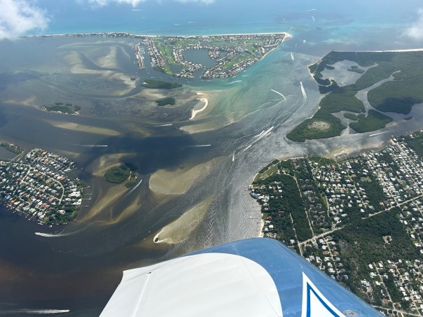
The aerials below taken by my husband, Ed Lippisch, on 2-14-24 around noon, 30 minutes before high tide, can serve as a baseline for comparison as our waters decline.
Presently, there is no representation on the South Florida Water Management District governing board as far as a traditional sitting Martin County representative. Appointed in 2019 by Governor DeSantis, I was removed in June 2023, really due to the power of the President of the Senate and those influencing her, for comments I made at a governing board meeting in February of 2022 in response to Senate Bill 2508, a bill undermining the District, water control, and the EAA Reservoir. In the the following months, I was not reappointed, as I could have been, by Governor DeSantis, nor was anyone else. Thus the seat sits open at this critical time. I believe I was removed not just because of my comments, but because of my knowledge and my record for speaking the truth. By a long and cruel silence we are being punished.
I will continue to advocate with the pen and with my voice for the St. Lucie River as I have since 2008 when I first became a Town of Sewall’s Point Commissioner and began to learn the dark history of Florida’s water policy. I want to thank the thousands of people and the many organizations who have helped in this battle. We must continue to “shine the light” and change water policy for the better as we have done and will continue to do. As we know, it’s a long and rocky ride.
~Jacqui
A not very full C-44 Reservoir, Indiantown, FL2-14-24 SLR/IRL at St. Luice Inlet. Ed Lippisch.
A few of the ACOE Periodic Scientist Call slides 2-14-24 that I screenshot
~ A tidbit from our upcoming book, A Pictorial History of Palm City, Florida, by Sandra Thurlow & Jacqui Thurlow-Lippisch
Palm City Post Office in the slash pine wilderness, c. 1914. Thurlow/Ricou Collection.
“You’ve got mail.”
In Palm City, in 1914, no one would have imagined email, texts, or cell phones. “Mail” meant a handwritten letter inside an envelope, one that may have been sent from very far away. One from a dear family member or an old friend. One about business opportunities. Having a post office was very important.
George Washington Jones signed the application for the Palm City Post Office on April 14, 1914. It was located inside his general merchandise store near Palmetto Street that later became Martin Downs Boulevard. Mr. Jones was postmaster, a very prestigious and important position in the growing community.
George Washington stamp, 1914. U.S. Post Office
It has been said that: “The history of the post office is the story of America.” Palm City’s post office played a chief role in bringing more people to the area. Letters from settlers shared information encouraging others to join them in Chillingworth’s remote Palm City Farms. One could call the post office, the “social media” of the day.
Palm City Post Office on the St. Lucie River with arriving horse and carriage, waving of American flag, but no post office sign. c. 1914. Thurlow Collection.
In this plat map from the 1920s it shows the location of the post office marked by a red dot. The St. Luice River and rudimentary bridge would be located to the east. Today we take such things for granted, but not in those days of yesteryear. The Palm City Post Office was a key place, a place where people came to get the “news of the day” or a “letter from a friend.”‘ Now we just look at our cell phones. Personally, I think I would rather sit, gossip, and wait on the porch at the old post office!
Plat map of Palm City, c. 1920s. Red dot denotes location of the Palm City Post Office between Palmetto Road and 1st Street. Today Palmetto Road is Martin Downs Blvd. and the street numbers have been changed. Thurlow Collection.
~ A tidbit from our upcoming book, A Pictorial History of Palm City, Florida, by Sandra Thurlow & Jacqui Thurlow-Lippisch
~Charles Curtis Chillingworth, 1868-1936, was born in Liverpool, New York and passed away in West Palm Beach, Florida. Pictured below at 45 years old, second from left, front row.
Alligator Smith aside, it is Charles Curtis Chillingworth “distinguished pioneer, citizen, attorney and developer,” who must be recognized as the “father/founder” of Palm City and Palm City Farms. In the early 1900s western Palm City Farms was sold in ten acre plots with a small bonus lot in what was termed Palm City on the St. Lucie. Today I am going to share a bit about Chillingworth the man, and how his development was marketed.
In my reading, I came to especially like Chillingworth because his autobiography notes his appreciation of nature, including the beauty of Florida’s iconic cabbage palm trees.
“As I remember of it, I left Atlanta one evening about the middle of October, 1891, and reached Jacksonville the following morning. Later that day I took a train on the old Jacksonville, Tampa and Key West Railroad, now the Atlantic Coast Line, which runs on the west side of the St. Johns River. I changed cars at Enterprise Junction for Titusville. That evening with the sun in the west just before sunset, I saw the first cabbage palmetto trees I ever saw in my life, and they made a great impression on me….”
So how did he come to develop Palm City Farms?
Chillingworth a young, hard working lawyer, eventually learned about lands west of the St. Luice River and wanted a part of development himself.
As he put it:
“In 1909 a real estate boom sprung up in South Florida, especially in the purchase of sale of large tracts of land.”
After much back and forth, Chillingworth took title to at least 12,000 acres from the Florida Coast Line Canal & Transportation Company. He then opened the Palm Beach Land Company in Stuart in 1911, because at that time what became Martin County lie in Palm Beach County, and Stuart had a small downtown area.
Chillingworth’s land office sold Palm City Farms. Historic Society of Martin County.
Chillingworth explains who helped him market the lands giving insight into those times:
“I took with me Miss Reilly, who had been my stenographer in New York during that summer. She was a most faithful and efficient helper and I made her Assistant Secretary of the new Company…”
Years later after Chillingworth’s death, Miss Reilly, now married as “Patsy Reilly McCord,” wrote a 1964 piece for the Stuart News about how Palm City Farms and Palm City on the St. Lucie were marketed. It is fascinating to read her account. Then, like now, it was not just the natural resources of the land, but of course also the beauty of the St. Lucie River that “sold” newcomers.
“Patsy Reilly McCord” was C.C. Chillingworth’s’ Assistant Secretary – here photographed in a beautiful Palm City Farms’ grapefruit grove, c. 1915. She helped organize trips for prospective buyers to see the beauty of the area to sell Palm City Farms and Palm City on the St. Lucie. Martin Digital History.
Patsy (Reilly) McCord wrote::
“The sale of land progressed, and in order to entertain the prospective purchasers, the Palm City Land Company purchased boats and automobiles and mule teams and large comfortable covered wagons for use in displaying the wonders of the rivers, ocean and plantations. The Palm Beach land Company took care of all prospective buyers by entertaining them and paying all expenses of their visit, while here, consisting of boat trips to the inlet, trips out the North and South Forks as well as wagon trips to different points of interest in the county, winding up with a trip to Palm Beach.
In those days, the waters of the St. Lucie were salty, (the inlet had been opened in 1892 and the St. Lucie Canal was not completed until 1924) and at night the water was so full of phosphorus the millions of fish looked like millions of streaks of lighting darting through the water. It was a wonderful sight in those days to be on the river in the darkness.”
WOW! It must have been beautiful!
The maps below will help you see the location of Palm City Farms and Palm City. I hope you enjoyed today’s “tidbit.”
Google maps with Palm City Farms subdivision overlay. Todd ThurlowMy mother’s color coding of township/range map of Palm City Farms – pink. The Hanson Grant is in blue.Chillingworth offered a lot in Palm City on the St. Lucie to those who bought ten acres further west in Palm City Farms. Note location of St. Lucie River for reference – 1911 plat map.
~Expresso and turquoise waters converge near the St. Luice Inlet and the confluence of St. Lucie River/ Indian River Lagoon, as seen on February 1, 2024. Even with no major discharges from Lake Okeechobee since 2018, dark waters from rain runoff and area canals remain apparent.
When I asked Ed to take more varied shots of St. Luice, he said this is difficult due to being in a restricted air space during takeoff and landing. Also, unlike days of past, there are many airplanes and jets coming in and out of Witham Field.
Lake O is currently at 16.30 feet and we are experiencing a “strong El Nino” which means “rain.”
Maybe I’ll go up with Ed soon and try for some long range photographs. I have only been up in the Vans RV once, last June, and brought my barf bag! It was actually a wonderful flight.
~Aerials were taken 2-1-24 at approximately 12:30pm by Ed Lippisch.
Peck’s Lake, IRL
~Images below are complements of South Florida System Update, Department of Environmental Protection, 1-31-24.
One of the earliest photographs of “Palm City,” along the St. Lucie River. Florida Photographic Concern, 1912-1913. Thurlow Collection.
In my previous blog post announcing my mother’s and my upcoming book, A Pictorial History of Palm City, I told the story of Palm City’s very interesting early homesteader, Alligator Smith. Today I will share another tidbit – how Palm City’s creation is connected to Smith, and how his 1891 “state of intoxication and drowning” in the St. Luice River inadvertently led to C.C. Chillingworth becoming the known founding father of Palm City Farms in 1911.
In 1891 C.C. Chillingworth was a young lawyer at Robbins and Graham soon to be working in Juno, the county seat of Dade County.
Chillingworth’s second case was civil in the United States Land Office. In those days thousands of acres of land were open for homestead-entry but one had to reside on the land for two years. It was Chillingworth’s job to prove that William M. Smith, locally known along the St. Luice as “Alligator Smith,” had “not abandoned” his 160 acre homestead, on the west side of the river. By law, a six month abandonment caused the homestead to revert back to the federal government.
An antique post card reads,” A Florida Native.” ca 1910.
Obituary of Alligator Smith, Tropical Sun 1891.
Jewelry made from alligator teeth, c. 1880s, Thurlow Collection.
Chillingworth’s autobiography written in his later years states:
“We were engaged about a week in taking testimony at Pottsdam, now known as Stuart and I had been unable to prove that Smith had been spending any time on the homestead during six months. Smith was drunk and fell overboard from a boat in the St. Lucie River on July 4, 1891. However when I began to check on the testimony and prepare a brief for the Register of the U.S. Land Office at Gainesville, Florida, I discovered that Smith had died just one day less than six months after he made entry.”
Smith seemed to have lost his homestead by one day!
The case was appealed to the General Land Office in Wahington D.C. and to the Secretary of the Interior, but in the end Chillingworth prevailed. According to my mother, the Bureau of Land Management documented that a Mr. George Mulligan ended up with Alligator Smith’s former homestead. How, we will never know!
These “coveted and valuable lands” located on the west side of the South Fork of the St. Lucie River are connected to today’s Palm City Farms developed in 1911 by none other that C. C. Chillingworth. Chillingworth’s familiarly with the lands of Alligator Smith inspired Chillingworth to develop Palm City Farms twenty years later. Without Alligator Smith, there would be no Palm City. I think we can say, Alligator Smith is Palm City’s real founding father!
Chillingworth offered a lot in Palm City to those who bought ten acres further west in Palm City Farms. Note location of St. Lucie River for reference – 1911 plat map.
Me modeling alligator hat holder and pin jewelry carefully arranged by my mother.
“And the Palm Tree Nodded to the Mirror in the Jungle.” Ormond, Florida. Stereoscope c. late 1800s, Thurlow collection.
Over the past year, I have been doing something wonderful. I have been working on a book about Palm City, Florida, with my mother, Sandra Henderson Thurlow to be entitled A Pictorial History of Palm City. We are having it proofed and edited now; it will be published sometime in late 2024. In the meanwhile, I am going to share some tidbits.
Have you ever wondered who was the first modern character of Palm City? He was a trapper. An alligator hunter who more than likely, over time, killed thousands of alligators selling their teeth of fine ivory to make jewelry. The trapper’s name? Of course, Alligator Smith!
Apparently, Alligator Smith was very well liked and fraternized with the likes of now famous names of our area such as Bessey, Stypmann and Krueger. However, my mother and I had different feelings towards Alligator Smith. I was really not fond of him and felt like “he got what he had coming to him,” when he died on July 4th, 1891 in a state of intoxication, falling off his boat, Magic, and drowning in the St. Luice River off of Sewall’s Point.
Mom saw him as a suvivalist. My thoughts? Perhaps after killing so many alligators on a river once named “Halpatiokee” which means “alligator waters” in a native tongue,“ the spirit of the river may have decided to take Alligator Smith home.
His real name was “William Smith” and he was working to obtain his homestead from the federal government at today’s Pendarvis Cove. As you’ll learn in the next post, “his lands” inadvertently seeded the creation of “Palm City.”
Stereoscopes became popular around 1850; today, they are considered the first step towards “virtual reality.”“And the Palm Tree Nodded to the Mirror in the Jungle.” Ormond, Florida. Stereoscope c. late 1800s, Thurlow collection.-writing on back
El Nino has not given us many sunny Florida days this winter; however, there have been a few. These aerials taken by my husband Ed Lippisch on January 10, 2024, around noon are an example of a rare sunny day. As mentioned in my last post, Lake Okeechobee has not been discharged to the St. Luice Riverheavily since 2018. Today, on 1-13-23, according to the Army Corps of Engineers, Lake Okeechobee is sitting at 16.06 feet. You can see from the 2024 chart below how the lake is creeping up since the new year. The 2023 chart below it, reveals numbers sometimes over 16 feet as well. There are a number of things causing uncertainly regarding lake operations. But on January 16th, 2024 the ACOE Periodic Scientist Call will occur. At this time we will get a clue of the fate of the St. Lucie. Hopefully nothing will change. Until then, you can go to eyeonlakeo.com and watch the numbers in close to real time while you email your favorite elected official.
~All aerials below were taken 1-10-23, Ed Lippisch
~St. Lucie Inlet with rain plume
~Looking west over Hutchinson Island, Sewall’s Point and Stuart. Just off of south Sewall’s Point is the confluence of the St. Lucie River/Indian River Lagoon
~St. Luice Inlet State Park (L) and Sailfish Point (R) on Hutchinson Island. Note lack of seagrass beds. There were once 700 acres of lush grasses in this area. Also called the Sailfish Flats
A strong El Nino 2023/2024 means higher than average rainfall for Florida.Most recent update, 1-18-24 via ACOE.
In case you haven’t heard about Martin Digital History, I’d like to share a bit of it today. Part of the library system, its “mission is to encourage the appreciation of Martin County’s unique history by collaborating with community members and local organizations to collect, present, and interpret relevant digital content.”
Some of the first cultural documents digitized at the encouragement of historian Sandra Thurlow were the old Martin County Chamber of Commerce Fishing Guides. I know many of my readers will appreciate these historic documents!
Here is a page from the 1935 fishing guide noting the St. Lucie River was “the Fishing Grounds of Presidents.” Pretty amazing all things considered today!
5 presidents who fished the St. Luice River.
A list of fish and the artwork of the 1935 cover note fish that are still found in the area but in much lesser quantities.
On December 31st, the eve of 2024, Ed photographed our region. On a bright sunny day after the settling of heavy El Nino rains, the camera revealed a world of beauty. Stubborn water quality problems and lack of seagrass habitat for wildlife persist but we are thankful for policy shifts that since 2019, have spared the St. Luice River major damaging, toxic discharges from Lake Okeechobee, and it shows.
El Nino’s guaranteed rains through spring, an entrenched legislative culture of protections for agriculture and development, and a lake sitting today at 15.97 will make this blue beauty difficult to hold.
But for today, it is a beautiful new year. Happy 2024 to everyone and may we continue to to speak out at any cost and may we continue to shine the light. J &E
~The St. Lucie River Indian River Lagoon
~Hell’s Gate, Sewall’s Point and Hutchinson Island where darker estuary waters collide with the incoming ocean
~St. Lucie Inlet at today’s Sailfish Point, Hutchinson Island
~Boats fishing over the reef off of Peck’s Lake in the blue and beautiful Atlantic Ocean. It is widely reported that only 3% of reefs have survived warming, pollution, and other stressors.
~Manatee Pocket bottom right -looking towards St. Lucie Inlet
~Rocky Point and St. Lucie Inlet State Park south of inlet. The once 700 acres of seagrass mostly bare. Like a plant in one’s yard it is dormant in winter but should not be absent
~The C-23 Canal divides St. Luice and Marin counties discharging into the St. Lucie River and is highly polluted from agriculture and development’s runoff. Reservoirs and stormwater treatment areas are underway by the ACOE and hoped to be completed by 2032.
“Until the public is able to understand how all of this stuff works, we’re never going to have accountability,” said Jacqui Thurlow-Lippisch, SFWMD Governing Board member 2019-2023. ~Article TCPalm “Florida’s BMAPs are Failing”
Literacy. It is the key to all things. Being able to read and understand allows one to SEE for oneself what works and what is broken. The Florida BMAP public process is broken. BMAP reports on “improving waterways” are painfully complicated and pollution is increasing not lessening. When the state legislature does not meet its goals dependent on the Department of Environmental Protection, the South Florida Water Management District and the Florida Department of Agriculture, politicians simply push deadlines into the future because BMAPs read like a foreign language and thus accountability by the public is impossible.
Now that will change.
Todd Thurlow, Eye on Lake O, has created “Water Data Maps” that are readable and easily show pollution levels so we can SEE the nitrogen and phosphorus killing our waterways and where it is coming from. We don’t need 15 years. We don’t need 30 years. We can see it today, for action today! Please explore the website and I will be writing more on this in the near future.
This past week, Ed and I took “Finito” from Stuart to anchor-out in Melbourne in the Indian River Lagoon. From foggy to bright blue skies, to hundreds of diving sea birds and thousands of bobbing ducks, this area once plagued by some of the worst algae blooms and loss of wildlife appears to be recovering. But good days during winter are not enough and we did not see one manatee. There is a long way to go and all is contingent on the state really getting on top of water quality issues which I plan to write a lot more about next year.
Today, as we approach Christmas, I share to inspire joy. Ed and I are wishing everyone hope, peace, and joy for the holidays along the Indian River Lagoon and everywhere!
A misty morning in VeroBeautiful sails approaching JensenSunset with Luna, MelbourneApproaching the beautiful waters of Ft. PierceBlue heron Crane Creek, MelbourneCobb’s General Store, since 188!, Ft. PiercePort of Ft. PierceCrane Creek old and new, Melbourne“No pedestrians allowed?” Isn’t this a sidewalk? Near Melbourne Harbour MarinaSign on door read “No dogs allowed,” Luna seemed miffed! Melbourne Harbor Marina 🙂Cormorants on the Melbourne Causeway BridgeMan fishing with wood storks nearby, Eau GallieAdorable ducks, Eau Gallie RiverStrange looking drone in Eau Gallie River!Sailboats south of Ft. PiercePelicans fishing at sunset, Ft. Pierce
Funny little crab amongst thousands of minnows being chased by Lookdowns – a fish I’d never heard of. Ft Pierce City Marina
Brightline is a new, colorful addition to in the area, and a controversial one too
Ed in front of Sunrise Theatre, Ft. PierceBeached sailboat mouth of Banana River and northern IRLBanana River very interesting to finally seeOsprey nest, St. Lucie RiverGoing home. Melbourne to StuartThere were thousands of bobbing little black and white ducks, Melbourne CausewayThe joy of a spectacular sunset, Melbourne, IRL
Luna goes for a ride!
Okee looks on wishing she were a dog
Bottlenosed dolphins were jumping on both sides of “Finito” south of Ft. Pierce! An incredible way to head home! I am sure they were saying: “Happy Holidays and thanks for protecting the IRL!”
Little water has been sent south from Lake Okeechobee as the EAA runoff is prioritized and, when rainy, the WCA are filled up like overflowing bowls. The SFWMD aims to “send water south” from Lake O, but it can’t unless there is capacity, and there rarely is…
Yesterday the Army Corps of Engineers announced that they will be allowing a deviation in operations for the Water Conservation Areas. You may recall my recent posts about the high water levels in the manmade, levied water conservation areas and the dangers to wildlife and tree islands and the fact that when they are “full” it is not possible to “send water south” to the Everglades National Park from Lake Okeechobee….
-which means that if the Lake is filling up the St. Lucie River is closer to being discharged to. Today according to the South Florida Water Management District the lake sits at 16.01 feet. If indeed the present strong El Nino unleashes torrents of rain this winter, as it already did on November 15, 2023, or even if not, and the ACOE wants to “plan” by sending non- toxic algae lake water to the estuaries before summer, we are hosed.
Why? Because the system was built that way. It was built to favor some and hurt others, to protect the Everglades Agricultural Area and South Florida from flooding by draining Lake Okeechobee into the St. Luice and Calooshahatchee.
OK. A lot of issues were accepted from the late 1800s through 1948 when the Central and Southern Florida Plan was built. That does not mean it is acceptable today. There are options that would greatly improve the situation, like having everyone including the EAA sugar lands hold water on their lands instead of using the lake like a pond at a homeowner’s association to irrigate their lawn! This is 2024 almost!
It is appreciated that the ACOE is allowing a deviation for the Water Conservation Areas and of course the animals and tree islands must be helped too. But we must realize this it is not enough to save the the St. Lucie River that is almost dead as it is. No false hope.
Thanksgiving is approaching and it is time to reflect. Ed and I are grateful. We are grateful to be able to document the successes and setbacks of the Central Everglades Restoration Plan or CERP from the air. We are thankful to have pilot friends like Dr. Scott Kuhns and professional pilot Dave Stone join us – they have been fellow River Warriors for ten years! The photos we share today do not show perfection but they do show determination. All photographs were taken on November 19th 2023 between 2 and 4pm. It is our story, all of our story, as shown from above.
Pilot Dave Stone of Ft. Meyers is a long time River Warrior. He is pictured here with his newly built and painted Vans RV at LaBelle Municipal Airport. (Photo Ed Lippisch)
The following seven photos are of the C-43 Reservoir part of CERP. The SFWMD had a few hiccups due to the contractor and Covid but is now “back on track.” This reservoir will be gigantic. According to the ACOE it is located on 10,700 acres of former farmland in Hendry County, Florida, west of Labelle, the Caloosahatchee River West Basin Storage (C-43) Reservoir will hold approximately 170,000 acre-feet of water, with the maximum depth ranging from 15 feet to 25 feet. To compare, the C-44 Reservoir in Martin County is on 3000 acres and should hold 15 feet too.
C-43 RESERVOIR
C-43 Reservoir is part of CERP and is under construction by the SFWMD. It is located near LaBelle along the Caloosahatchee River. (Ed Lippisch)The ACOE Integrated Delivery Schedule, its calendar for everything, for 2023, is aiming for 2028 to complete the building of the C-23 Reservoir.
Lake Okeechobee clear of visual algae in cooler months. Looking NE.
C-44 RESERVOIR
The C-44 Reservoir in Martin County, FL is part of CERP and Indian River Lagoon South. It is undergoing studies for seepage, so holding water but not full amount.C-44 Reservoir is part of CERP and a component of Indian River Lagoon South.S-308 at Port Mayaca is attached to the C-44 Canal, the canal the C-44 Reservoir is built to to clean before water through reservoir and storm water treatment area before it is released to the St. Lucie River.
ST. LUICE RIVER/IRL
The confluence of the St. Lucie River Indian River Lagoon meets at the St. Lucie Inlet built by hand by locals in 1892. Note erosion of Jupiter Island south.October and November bring King Tides flushing out the inlet area and pushing back dark runoff and canal waters.The Atlantic Ocean has been rough and is stirred up.A southeastern look over the peninsula of Sewall’s Point clearly reveals the importance of tidal flow. The north and south forks and even the main do not get this extensive flushing. Due to discharges events in 2013, 2016 and 2018 seagrass loss has been significant. The goal is for the building of reservoirs and STAs of CERP to halt the damage, for that we are thankful.
Thursday, November 16, at the Rivers Coalition meeting held at the Stuart City Commission Chambers, 121 SW Flagler Avenue, 11am, Merritt Matheson will present. Matheson, from the famous Matheson family, was once a commissioner for the City of Stuart himself. Now serving on the Indian River Keeper Board of Directors and the Rivers Coalition, he is continuing his good work as a face for MARTIN COUNTY FOREVER.
You may have heard of it?
If not, I’ll share a bit of what I have learned to wet your whistle, and I encourage everyone to attend the meeting in person or Zoom. (For Zoom mail Info@RiversCoalition.org or call 772-225-6849)
We all know the county is rapidly being developed. It’s hard to watch.
If Martin County Forever gets supported by the Martin County Commission to go on the the ballot for voters to decide whether to support land acquisition, Martin County Forever can offset that loss. Martin County has already done a great job acquiring lands in the past. I think people will support Martin County Forever as it will only be about land acquisition. As the land so the water…
According to Martin County Forever literature, over 116,000 acres have been identified on the Martin County Land Acquisition Map (above). In years past, with community support, about 61% or (71,000) acres were acquired, leaving approximately 46,000 acres left that can still be acquired. Target areas include Blueways, the Indian River Lagoon watershed, Loxa-Lucie and Pal-Mar. These are beautiful areas that need to be saved and could become part of a so needed east coast wildlife corridor. The only lands for consideration are those eligible for state funding to match due to previous designations.
I commend Merritt for his conservation work and for never, never, never giving up! I hope you can join him.
All slides and photographs courtesy of the MC Forever website and FB page.
C-23 Canal separates Martin and St. Lucie counties as does an ideology.Citrus Boulevard runs through what will become Newfield.An interesting look at some remaining natural features.Cobblestone cradled into I95, a concept once frowned upon and now popular.The C-44 Reservoir in Indiantown holding 7 feet of water rather than 15 due to seepage issues.C-44 Canal and S-308 at Port Mayaca, w/Lake Okeechobee algae free in cooler weather and standing at 16.20 feet.Sugar fields surround Lake Okeechobee and in recent years are increasing in Martin County.St. Lucie River/Indian River Lagoon – looking north over St. Lucie Inlet Park on Jupiter Island.A slender plume exits the St. Lucie Inlet, from rain and runoff of C-23/24 and the surrounding basin, but no Lake O water.Seagrass beds between Sewall’s Point and Hutchinson Island were ravaged in 2013, 2016, and 2018 due to Lake O releases and have been slowly coming back but with microaglae coating them. The once 700 acres is much lessened.Looking over Rocky Point to the St. Lucie Inlet. Rocky Point has one of the few parks that displays native vegetation, “Maggy’s Hammock Park.”Sewall’s Point was said to be “the most beautiful of all” in the topological survey description of this region in 1883. Most of the native jungle like vegetation and topography that inspired this title has been removed for today’s taste in development. You can see what was like in 1883 or near to it if you visit “Maggy’s Hammock Park” in Rocky Point. A treasure!
Ed and I just got off a seven day journey on “Finito.” We traveled along the Indian River Lagoon from Stuart to Cape Canaveral and only turned around due to a fuel leak that was heroically brought to our attention our eighty pound Belgium Shepherd, Luna.
Luna although a bit crippled walked to the front to bark and alert us to the smell of gas in the salon. Ed and I were upstairs in the pilot house.
The Lagoon has been through hell the past decade, especially in regards to algae blooms that began around 2010 and peaked in 2013. Over 90 percent of seagrasses in the 156 mile lagoon died off in those and the following years and FWC still reports issues including fish kills. I believe that the lagoon is improving in spite of continued difficulties. Just the past few days the water quality the length of the lagoon looked appealing and there were dolphins jumping in our wake the entire trip! Dozens of them, all along the way! These clever animals will always find a fish, in spite of crappy water, but nonetheless, their presence was inspiring.
Even though this was to be the “retirement cruise,” I couldn’t help myself from zooming into a Rivers Coalition meeting on October 26 and was impressed that for the second time in row since I was ditched by the Senate, South Florida Water Management District executive staff and a governing board member drove all the way from West Palm Beach to attend the meeting. Obviously this is done for their self preservation, but still!
The subject of the meeting was “Sending Water South,” and basically the theme, in line with my last blog post, was that the the high water in Water Conservation Areas south of Lake Okeechobee makes sending water south right now “impossible.” Staff said they were draining the WCAs now, the Storm Water Treatment Areas are restored, and they hope to send Lake Okeechobee water south in December. Of course no one mentions this bottleneck is caused by the Everglades Agricultural Area….
I found this possibility about sending water south in December misleading. In fact, it was False hope. Sure there is always a possibility that things will not turn out as science plans, but we should recognize science nonetheless. Especially as the District is based on science has its own scientific weather bureau that is so respected the ACOE relies on its data!
Two days prior to the Rivers Coalition meeting the District hosted a Water Resource Form. During this forum the high probability of above average rainfall December 2023 through February 2024 over the sixteen county South Florida Water Management District was noted. This is due to a weather condition known as El Nino. So back to the Rivers Coalition meeting, what if as science is revealing, we do not have a dry season and it rains over the Water Conservation Areas? Hmmm? Then the SFWMD probably wont be able to send water south in December, or January or February and tree islands and fur-bearing animals will continue to suffer as will we. This may have been mentioned in passing but it was not discussed.
Lake Okeechobee is discharged east and west when determined too high by the ACOE.
I rather be prepared for something that may happen than have my government spoon feed me false hope gliding over serious issues. A scientific agency has the responsibility to share science not hope.
Yesterday, I listened to the South Florida Water Management District’s Governing Board meeting via Zoom. The overriding issue, besides the fact the St. Lucie River system’s C-44 Reservoir is not working, Lake O is over 16 feet and discharges could soon be imminent, was “high water in the Water Conservation Areas.”
What are WCAs anyway?
They were built as part of the giant drainage system of Florida that “over did it.”
The Water Conservation Areas were built to hold water because we had over-drained, but now sometimes they get too full…
In 1947 there was “the great flood,” that destroyed lands and properties in the seventeen counties of the Everglades Drainage District. This led to the U.S. Army Corps building the monstrosity named the Central and Southern Florida Project for Flood Control and Other Purposes (C&SFP.) The S.F.W.M.D. is the local sponsor. The two agencies work together.
United States Geological Survey explains:
“Historically, water flowed slowly southward through the Everglades in a wide swath. Record floods in 1947 and 1948 led to the construction of a massive flood control project. It served to prevent flooding and store water during dry periods. It also allowed for further development of the growing urban area on the Atlantic coastal ridge.
The project established three Water Conservation Areas (WCAs), one of which is the Loxahatchee National Wildlife Refuge. These areas are delineated in the Landsat images, clearly divided by the levees and canals. Also visible are the Big Cypress National Preserve, Everglades National Park, and Everglades Agricultural Area.Another part of the project is the 100-mile-long eastern perimeter levee, a 3- to 6-meter high earthen berm built to prevent flooding of farmland and urban areas. It runs along the eastern edge of the WCAs, marking a clear separation between the WCAs and urban areas such as Miami, Fort Lauderdale, and Coral Springs.
Along with facilitating the further growth of the urban areas of greater Miami, the other upshot of the project was that the natural flow of water was interrupted, changing the hydrology of the region. The gradual sheet flow of freshwater is diminished, and instead sudden pulses of water are delivered by the canals. These sudden releases caused decreases in the numbers of fish species.”
The bottom line is that when there has been significant rain, like now, the WCAs overfill and the fur bearing animals are seriously at risk, unnaturally surrounded by rising water with no access to their habitat. Deer and other mammals have to take refuge on sacred Native American tree islands or on levees. Often, many species are desperately standing together. Friend and foe. All stressed, all scared, and all hungry.
In 1982 there was a so called “mercy-killing” of over 700 deer that were “starving” in the flooded Water Conservation Area 3. There are concerns that this year a similar situation could arise. I recommend watching the SFMWD meeting under section 28 and all public comments and more if you have the time. This is a very serious issue and no way to treat God’s creatures. How we treat humans during Lake O discharge events is bad enough. It is time to undo the past.
Brother Todd: “Did you guys see the sun this morning? I never stop on my morning run but I had to pause to take a picture. It looked like the moon.”
Jacqui: “Yeah, really something. When I drove over the bridge twenty minutes ago on my way from Sewall’s Point to Stuart, I said to myself ‘what is that?’ The sky looked like a huge fog bank coming from west to the east.”
Sister Jenny: “There is some weird haze in the air. Does anyone know what it is? I got an air quality alert on my radar and I saw it last night and this morning.”
Todd: “Looking at satellite imagery now. Unbelievable stream of smoke. I will try to compile and send.”
Deanna: “The article mentions Central Florida, but wondering is it is stretching more south towards us? Wouldn’t be surprised with all this crazy wind we’ve been having.”
Mom Sandy : “You guys amaze me.”
Todd: “Smoke being sucked down from south of Hudson Bay on September 28. If you zoom in you will see a little read dots Those are thermal anomalies (wildfires being picked up by the satellite.”
Jacqui: “Photo doesn’t do justice. Smoke is all around, more than Stuart. I am in Palm City now. You’d think the fire was burning nearby in Okeechobee, not Canada.”
“If you live in Florida, you may have noticed the smoke in the air on Tuesday morning, October, 3, 2023 This is a two-day loop of 276 GOES-East satellite images, 10-minute intervals from 10/2/2023 @ 9pm to 10/3/2023 @ 8pm. You can see a low pressure system in the northern Atlantic. That system pulls a stream of smoke from the northern Atlantic towards Florida on 10/2/2023. It arrives overnight and is over Florida on the morning of 10/3/2023. The north Atlantic smoke originated from wildfires near Hudson Bay in Canada. You can make the video loop by right-clicking the video and selecting “loop“. ~Todd Thurlow
Yesterday, I attended the Rivers Coalition meeting. It was a nice surprise to see so many members of the South Florida Water Management District as they were not listed on the agenda. “The District visitors” included Drew Bartlett, Executive Director; Laurence Glenn, Division Director, Water Resources; Sean Cooley, Chief Communications and Public Policy Officer, Office of Communications and Public Engagement; Kathy LaMartina, Regional Representative, Orange, Osceola, Polk, St. Lucie and Martin Counties; and Governing Board Member, Cheryl Meads, At large East Coast, St. Lucie, Martin, Palm Beach, Broward, Miami-Dade and Monroe counties.
Cheryl Meads, at large governing Board member SFWMD.
The Rivers Coalition Meeting itself was entitled“Get the Muck Out of Here” and featured Joe Gilo, Lake Okeechobee Restoration Initiative, and Len Lindahl, McVicar Consulting/Diatom Project. Both presentations focused on improving water quaintly in the lake, an essential goal. Very interesting, but the presentations and question/answer sessions were cut short due to time.
Having the South Florida Water Management District as a guest is a rare honor thus they spoke before the planned speakers. Mr. Bartlett shared lake level facts and why water from Lake Okeechobee cannot be sent south when the Water Conservation Areas are already full. He mentioned that the new A-2 Storm Water Treatment Area is meant more for Lake Okeechobee Water. I wasn’t sure why he called it the “A-2” as we all know it as the “EAA STA.” No matter what it’s called, we all know that Mr. Bartlett is a talented executive director.
Mr. Glenn talked about the intricacies of managing the health of the Storm Water Treatment Areas and their legal job to cleanse the runoff water and meet water quality standards for the Everglades Agriculture Area. (Thus their water has priority to go through the storm water treatment areas first – hmmm?”)
Over the course of the meeting, what made the biggest impression on me, was when Drew Bartlett introduced Cheryl Meads as governing board member -“local representative.” Over the course of the past couple of years, Cheryl has moved from Islamorada, in the Florida Keys, where she first lived when appointed to the South Florida Water Management Governing Board, to Martin County and owns other properties in nearby counties. Cheryl and I both served as at-large members living in Martin County.
Governing Board seats 1-9, SFWMD.
Although I was reappointed by Governor DeSantis for a second term serving on the South Florida Water Management Governing Board, I was not reconfirmed by the Senate and my term expired on June 19, 2023. Since that time, there has been no representation for “that seat” and we have all been waiting for a new appointment by the Governor. In August, three members were rereappointed: Chair Chancy Goss, Vice-Chair Scott Wagner, and Jay Steinle. It was thought that at that time, “the empty seat” would be filled. It was not.
I have to assume that yesterday’s gesture of Cheryl Meads being introduced by the Executive Director as the “local representative” implies that she is being directed to represent the Treasure Coast. Cheryl is a wonderful and environmentally oriented person as are all of the present governing board members. However, she is not a homegrown, fighting, St. Lucie River Warrior. At large members represent the entire east coast and when covering the “primary outlet” for the destructive discharges of Lake Okeechobee, the St. Lucie River requires special knowledge and attention. Please share with Cheryl your experiences and concerns. She is your new District voice!
JTL, Sean Cooley, Cheryl Meads.Joe Gilio & Lin Lindahl
Toxic Lake Okeechobee, June 11, 2023 , Ed Lippisch
Today I share Finding II. of “Conclusions of the Special Project to Prevent the Eutrophication of Lake Okeechobee Relevant to Management Determination for the Everglades Agricultural Area,” Draft Copy, 1975.
Again, I state how important it is that this historic documentation is not stored in our state archives like something out of “Raiders of the Lost Ark,” but rather ready and available to the public. Otherwise, history is rewritten by those with most the power and influence.
For instance, today, one will ofter hear in regards to pollution in Lake Okeechobee, –from those working for and in the EAA,– “The Everglades Agriculture Area (EAA) doesn’t backpump anymore. Our water is cleaner when it leaves than when it came in.” (basically, we are not responsible for the condition of Lake Okeechobee, others are….)
What is missing in this response is that in spite of its numbers the Everglades Agricultural Area remains responsible for damages that plague Lake Okeechobee TODAY.
If you smoked unfiltered cigarettes from the 1940s through the 1980s and then, because of a law suit, the University of Florida and the South Florida Water Management District helped you create “Best Management Practices” that did a great job cleansing your smoke through giant air filters, (like Storm Water Treatment Areas filter the EAA’s dirty water of nitrogen and phosphorus,) would it be correct to say the damage in your lungs has disappeared?
No. The damage in Lake Okeechobee from backpumping is still there and continues to be built upon. The filthy backpumped water of the past is a major reason for the pathetic condition of Lake Okeechobee today. It is time for the EAA and its masters to take responsibility for this and to stop hiding behind their modern day state sponsored improvements.
~begin text:
“With regard to eutrophication of Lake Okeechobee drainage water from 30 percent of the EAA land area is back pumped into Lake Okeechobee during the wet season. An average of 330,000 acre-feet of water entered the lake annually at Structures S-2 and S-3 from the Miami, Hillsboro and New River Canals . In addition drainage districts and the private interest pump approximately 150,000 acre feet of water into the lake from various locations. The EAA irrigation demands draw an average of 438,000 acre-feet from the lake annually…”
Conclusions of the Special Project to Prevent the Eutrophication of Lake Okeechobee Relevant to Management Determination for the Everglades Agricultural Area, Draft Copy, 1975.
Finding II.
Water Backpumped from the Everglades Agricultural Area contributes significantly to the cultural eutrophication of Lake Okeechobee.
The following research evidence is proffered in support of Finding II.
(page 23.) Joyner (1974) found that water pumped from agricultural areas to the southeast is generally the poorest in quality of all water entering Lake Okeechobee….
(page 24.) Brezonik further states: It is clear from the data that Lake Okeechobee presently receives an abundant supply of nutrients. Both nitrogen and phosphorus loading rates or near or above all the (dangerous) levels reported in the scientific literature. (Table 2.) If all backpumping were ceased, the nutrient loading rates would decrease by about 20 percent. This would still leave area loading for nitrogen above the dangerous values, but the volumetric rate would be slightly under the dangerous volumetric rate of Brezonik and Shannon (1971). The photophores loading without backpuming would be lower than all but Vollenweider’s (1968) dangerous rate….
Today I share aerial photographs taken by Ed Lippisch on September 17 around 9:30 am to 10am. The great thing about a photograph is that it speaks for itself! We have avoided a recent tropical storm or a hurricane’s impact on Lake Okeechobee, but the lake remains high at 15.41 feet as reported today by the SFWMD. Stormwater and canals C-23, C-24 continue pollute and discolor the estuary. Remember no fertilizer use during rainy season or if you’re like me EVER! Stay vigilant as hurricane season runs from June 1st through November 30th. Your eyes in the sky, J&E
Today I share an excerpt form “Conclusions of the Special Project to Prevent the Eutrophication of Lake Okeechobee Relevant to the Management Determination for the Everglades Agricultural Area,” Draft Report, State of Florida 1975. It is important that historical information like this is available to the public. It is mind-boggling that in 2023, seventy years since 1953, the issue of eutrophication of Lake Okeechobee has only worsened. Every year the estuaries are plagued by the threat of discharged toxic algae. Reports like this one lie buried in Florida’s state archives in Tallahassee. Most legislators have probably never read it. What has been done to improve water quality is not enough.
Finding I.
Lake Okeechobee is presently enriched and moderately eutrophic. If the present trend of increasing nutrient loads from the drainage basins is not reversed, the lake could become hyper-eutrophic within the foreseeable future.
The following research evidence is proffered in support of Finding I.
In 1953, Dr. H. T. Odum sampled the phosphorus content of Lake Okeechobee and tributaries to the lake. Although not enough samples were taken to have statistical significance, the values of the samples were well below levels consider to be eutrophic.
In 1953, the lake’s watershed was essentially undeveloped. The fact that the lake had low phosphate values in the water column indicates that the lake was not eutrophic in 1953.Water quality samples taken since 1953 have all shown phosphorus values higher than those taken by Odum. This indicates that present levels of phosphorus in the lake result from man’s drainage and land-use practices in the drainage basins.
Today I am including notes from: Draft, A Summary of Progress of the Special Project to Prevent the Eutrophication of Lake Okeechobee, 1975, inspired by my last post. This draft report eventually led to de-chanalizing a substantial portion of the Kissimmee River, the halting of backpumping by the Everglades Agricultural Area, the beginning of Best Management Practices for Agriculture, and conservation for drinking water.
It must be noted that it was the Central and Southern Florida Plan of 1948, after the great flood of 1947, implemented by the Army Corps of Engineers that channelized the Kissimmee River and created the Everglades Agricultural Area (EAA). It took me years to understand this. The EAA and its flood protections were created by our federal government. Then acting in lockstep our state government morphed the Everglades Drainage District into the Central and Southern Flood Control District to manage the Central and Southern Florida Flood Control District-which included the Everglades Agricultural Area. In 1975, around the time of the Draft publication, the Central and Southern Florida Flood Control District was been renamed the South Florida Water Management District. The intensions of the Draft were good, but conflicts of interests continue today with management of the EAA, on both the state and federal level.
Think about it.
So once it was decided the Everglades Agricultural Area could no longer back pump into Lake Okeechobee due to the lake’s eutrophication, the EAA’s government sponsored pollution led to the law suit that now requites all Everglades Agricultural Area “runoff” to go through the Storm Water Treatment Areas to be filtered before it gets to the Conservation Areas thus Everglades National Park. “Lake Okeechobee water” on the other hand sits cooking toxic algae in the still sick lake, before it is sent polluted, unfiltered to the St. Lucie and Caloosahatchee estuaries and residents of those estuaries have no legal standing.
Hmmm?
The Everglades Agricultural Area south of Lake Okeechobee was created and is protected as part of the ACOE and SFWMD’s C&SFP, c. 1948-61.
Begin quotes from text, 1975:
Water back pumped from the Everglades Agricultural Area contributes significantly to the cultural eutrophication of Lake Okeechobee. (pg. 23)
The major causative factors of the present cultural eutrophication of Lake Okeechobee are:
Canalization of the tributary rivers of streams (especially the Kissimmee River).
Backpumping of highly enriched waters from the Agricultural Area, south of th lake , into the lake during the wet season.
Upland drainage practices in the lake’s watershed.
Inadequate nutrient conservation, livestock management, and other agricultural practices in the watershed.
Management and regulation of the lake and its tributaries which diminish their ability to absorb nutrients. (pg. 5)
In view of the fact that the cessation of back pumping would result in a reduction of the lakes present water budget by some 12-14 percent and that water conserving is one of the over-riding management objectives for the South Florida region the committee recommend further that “runoff water from the Everglades Agricultural Area be stored in or near the EAA for subsequent re-use as irrigation water.” This will alleviate the present need to use an average of 350,000 acre feet of water for the lake for irrigation in the EAA and balance the loss of the present 330,000 acre feet contributed to the lake by back pumping. (pg. 10)
Legal and Administrative Aspects of Management have been created and charged with managing various aspect of the region. The present management structure evolved in piecemeal response to growing management problems. Agency responsibilities often overlapped and conflicted and there is no balanced, integrated, or well directed management program for the region. (pg. 11)
Since 1948, the major resource management agency in South Florida has been the Central and Southern Florida Flood Control District which was created to manage the Central and Southern Florida Flood Control Project constructed by the U.S. Army Corps of Engineers. (which includes the EAA.)
I recently received some very interesting comments about a post I wrote in 2022 featuring state archived documents. The title? “Summary of Progress, Final Report on the Special Project to Prevent Eutrophication of Lake Okeechobee.” I decided to share the post again in a different way.
Sometimes looking back makes you wonder if you are going forward…
The hand written corrections and typewritten format on the document really bring it home:
Paragraph two: “The lake has been and is being degraded. Poor land and water management practices in the drainage basin threaten to further degrade and destroy the lake’s indispensable values. This was recognized as early as 1971…”
Yesterday, September 2, 2023, my husband Ed flew from Stuart to La Belle located along the Caloosahatchee River. I asked him to take some aerials of the C-43 Reservoir that although having some tribulations will one day will be similar, but larger, than the St. Lucie’s C-44 Reservoir. Ed agreed and a took some interesting pictures. Ed also took some aerials of the St. Lucie/Indian River Lagoon that was whipped up and milky looking from eight foot seas pushing sand into the inlet from the Atlantic Ocean.
Check out Todd Thurlow’s amazing site, EyeonlakeO, which in “real-time” measures Lake Okeechobee at 15.38 feet, even after Hurricane Idalia. Hurricane season has at least two more months to go, so we are not home free yet. The ACOE and NOAA are vigilant.
We continue to be your eye in the sky! See you next week. J&E
I. C-43 Reservoir under construction, along Caloosahatchee River. 9-2-23, about 10:55 am. EL
II. St. Lucie River/Indian River Lagoon with strange milky look due to high seas, 9-2-23, about 11:30 am. EL
III. S-308 Port Mayaca, Lake Okeechobee visible blue green algae (cyanobacteria) has lessened with cooler weather, but lake water is terribly polluted and blue-green algae remains just dormant. Presently there is no discharging by the ACOE from Lake O into the SLR/IRL. Runoff from C-23, C-24 and C-25 and area runoff continues. 9-2-23, 11:20am. EL
I hadn’t even opened my eyes this morning when Ed yelled up the stairs: “Jimmy Buffett died.” I picked up my phone from the floor and there was a text from my brother, from my mother, and from my sister. We went back and forth recalling favorite songs and even a concert. Days of youth in a world so different than today.
I put down the phone.
In disbelief I stared at the wall thinking “Not Jimmy Buffett!” A tear formed in my eye as a flood of memories rose to the surface, especially about my late father.
Middle and high school, days working as a receptionist at his law firm over summer, driving in with him dressed in tie and suit fulfilling the sometimes thankless job of father and provider. We’d get in the car and I just hoped he’d play Jimmy Buffett. It would make us sing. It would make us laugh. It would make us forget. It would make us remember. It bound us as father and daughter and as Floridians.
I’m sure you have a lot of memories connected to Jimmy Buffett too.
Once I saw Jimmy Buffett live, not singing, but giving advice…
Today I repost a blog post from May 15, 2015. It was Ed’s niece Darcy’s University of Miami graduation day. The commencement speaker? None other than Dr. Jimmy Buffett. I hope you’ll enjoy rereading this post as much as I did and the speech at the end? Just like his music, it will make you want to sing along…
These aerials were taken by my husband, Ed Lippisch, on August 27, 2023 around 12:15pm. Other than an operational burp from Lake Okeechobee through C-44, it’s canals C-23 and C-24 which drain Port St. Lucie, Allapattah Flats, as well as our Tidal Basin – that are causing the present discoloration and decline in water quality. On a good note, though impaired, seagrass beds are visible near the Sandbar and algae is no longer seen from 1000 feet at Port Mayaca.
As we enter the primary hurricane season it’s unfortunate the alternative canal through the Everglades Agricultural Area once considered by the ACOE in the 1950s to alleviate the discharges is not in place. If history does indeed repeat itself, we must be prepared for more rain and Lake Okeechobee destruction added to the St. Lucie River/Indian River Lagoon.
Most recent ACOE/SFWMD SLR update, 8-22-23Lake O history, ACOE/SFWMD
Rain and runoff plume exiting St. Lucie Inlet Visibile seagrasses and macroalge Sailfish Flats Sewall’s Point between the St. Luice and Indian RiverPeck’s LakeSL Inlet w/ plume
Sailfish Point on Hutchinson Island is next to St. Lucie Inlet S-308 at Port Mayaca C44 Canal aka St. Lucie Canal – no algae visible from 1000 feet
Ed’s RV is having its annual so on August 16, 2023 Ed went up in the SuperCub with Scott Kuhns. It was early morning and lighting limited successful outcome of photographs. Thus I have chosen a just a few, that for me, are impactful in what they say about development and agriculture and our environment. JTL
Roosevelt Bridge, Stuart, Florida.North River Shores, Martin County, Florida.Tradition, St. Lucie County, Florida.Cutting up the western lands, Tradition, St. Lucie County, Florida.
Sugar’s perfect water-control. Martin County, Florida.Blue-Green algae in St. Lucie Canal (C-44), Martin County, Florida.S-308 at Port Mayaca, St. Lucie Canal (C-44), Martin County, Florida.Ed as a passenger over Lake Okeechobee, SuperCub of Scott Kuhns, 2023.
Ed’s comment when he came home from flight yesterday was “not as bad as last time.”
Today’s aerials were taken 8-6-23 around 1:30pm. One can see blue-green algae, along the eastern shoreline of Lake Okeechobee, but not as much in the C-44 canal.
The St. Lucie River looks a bluer near Sewall’s Point- perhaps thanks to recent full moon tides and less rain runoff. Seagrass meadows covered in increasing a cyanobacteria and macro algae are visible. The seagrass is returning, but not in as good a shape, after massive and longterm Lake O discharges in 2018, 2016, and 2013 and decades of destruction.
Sandbar near St. Lucie Inlet, 8-28-23, FB Mike Yustin
Ed and I continue to be your “eye in the sky” and Todd is helping all of us keep an eyeonlakeo now at 15.30 feet according to the SFWMD. Hurricane season should start ramping up. It is not a good situation. More water should be able to be sent south as God intended.
~Lake O, Rim Canal, and C-44 at Port Mayaca’s S-308
~St. Lucie River-Indian River Lagoon. Sewall’s Point divides these waters.
~Note seagrass beds in next two photos. Once 700 acres now much less and impaired. Good to see it in any case!
Thanks Ed!Canal system of CSFP SLR/IRL. credit SFWMD
Northern Lake O algae bloom On Saturday, July 29, 2023, my husband Ed returned from flight with 103 aerial photographs of the St. Lucie River to Lake Okeechobee. When there are so many photographs it is difficult for me to decide which ones to include so I have shared most in gallery format.
The St. Lucie River continues to be darkened by C-23, C-24 and storm water runoff while Lake Okeechobee continues to suffer from cyanobacteria blue-green algae blooms primarily in the north. Ed said there was algae in the middle of the lake but that it was more like a “sheen.” Like gasoline on water.
Ed’s photos show algae on both sides of the St. Luice Canal (C-44), but none at S-80, St. Lucie Locks and Dam, and little visible in the lake -again just a greenish color- at S-308 at Port Mayaca lakeside.
The algae in north Lake Okeechobee is dramatic and looks more clumped than I have witnessed previously. Perhaps wind and rain? Strange…
The only good thing I can say is that the ACOE and SFWMD continue to recommend no discharges from Lake Okeechobee to the St. Lucie River. We’ll see about next week.
On July 25, my brother Todd Thurlow eyeonlakeo texted me that S-308 was open at 1656 cubic feet per second but S-80 remained closed. I would imagine this water let in from the Lake Okeechobee was for canal levels or water supply of agriculture. If I were growing crops I would not wish to accept this water as University of Florida Institute of Food and Agriculture Sciences UF IFAS had notes: “Cyanobacterial toxins can accumulate in crop plants, resulting in injury and yield loss; human health may be affected. Impacts of field crop exposure to cyanotoxins in irrigation water are unknown.”
Known or unknown, it can’t be good.
The historic role of agriculture supported by our state and nation is the primary reason the lake is in such awful condition today; this has been documented since 1969. (U.S. Geological Survey in cooperation with Central and South Florida Flood Control District two year study on chemical and biological conditions of Lake Okeechobee, Beyond the 4th Generation, Lamar Johnson 1974.)
Locktender’s house at St. Lucie Canal lock #2 in the Everglades Drainage District. 1913 (circa). State Archives of Florida, Florida Memory.
I love this old photograph. I would think it must have been taken sometime between 1916 and 1925 when the Everglades Drainage District was constructing or repairing, (1924), the St. Lucie Canal. Yes, the lonely little house in the wildlands of a slash pine forest saw the the construction of the canal, the lock and spillway, the first locktenders, some wicked storms like the hurricane of 1928 causing the Army Corps of Engineers by 1930 to take over management of both Lake Okeechobee and the St. Lucie Canal. In 1937 the canal was rededicated as the “Cross State Canal, or Okeechobee Waterway.” It was deepened and widened for higher discharges and for more yacht traffic. By 1941 the St. Lucie Lock and Spillway was replaced as part of this expansion and the southern banks were drastically cut in the direction of the little locktender’s house. I can imagine the stories this little house would tell! Today we don’t have the little house, but we have the next best thing, my little brother!
Watch Todd tell the remarkable history of replacing the lock and spillway and the location of the original locktender’s house throughout the canal’s changes. Todd brilliantly uses historic aerials and images juxtaposed to Google Maps some shared by my mother Sandra Thurlow.
~The site plan: “U.S. Engineer Office – Jacksonville, Florida. Sept. 1938… To Accompany Specifications June 27, 1939.
~The aerial photo with the locks under construction is dated 2/23/1940
~On Florida Memory the picture of the little house is titled cited “Locktenders house at St. Lucie Canal lock #2 in the Everglades Drainage District. 1913 (circa). State Archives of Florida, Florida Memory.
~1940 Aerials, U.S. Dept. of Agriculture
~Dr. Gary Goforth, 2014 History of the St. Lucie Canal
Early Locks, Thurlow Archives, Courtesy Sandra Henderson Thurlow.
2024 will be the 100 year anniversary of the St. Lucie Canal…
Courtesy Dr. Gary Goforth, History of the St. Lucie Canal 2014.
Today I share my husband Ed Lippisch’s aerial photographs and one video taken around 11:30am on 7-23-23. Also included in the post are photos of reemerging seagrass beds taken by my brother Todd Thurlow on 7-2-23. A wonderful thing although Todd estimates that just under 80 acres were in the area he visited.
The St. Luice River/Indian River Lagoon is dark from rain, C-23 and C-24 discharge, and stormwater run-off, however most of the ocean looks gorgeous blue. You can even see the nearshore reefs. Seagrass and or macro-algae appear near the sandbars just inside the inlet. Not the 600 acres of yesteryear but some, and this is a good sign. There has been no discharge of Lake Okeechobee since April and that was a small amount with no algae. Nonetheless, it is never good for the river.
Lake Okeechobee shows no major algae blooms near S-308 as just a week ago at Port Mayaca although one can see the long green wisps like shadows in the water. This changes every day and you can follow at eyeonlakeo. This is Todd’s site and it shows Lake Okeechobee at 15 feet. Pray for no hurricanes.
There is algae on the inside gate of S-308 and some along the St. Lucie Canal also known as the C-44 canal as titled when it became part of the Central and South Florida Flood Control Plan of 1948. S-308 is overseen by the Army Corps of Engineers since 1930 but the South Florida Water Management District is involved spaying peroxide pellets on the algae when it gathers in big blue-green-gray rotting clumps as it did last week. The algae dies but more than likely sinks releasing toxins. A conundrum most definitely….
Thank you to my husband Ed who is in his tenth year documenting our waters by air. All of working together are make a difference. We are watching and they know it.
ACOE documented algae at S-308 on 7-13-23.
TODAY’S AERIALS, 7-23-23 by ED LIPPISCH
Sailfish Flats between Sewall’s Point and Hutchinson Island – note seagrass and macro algae in dark waters.
Seagrass with macro-algae near Sandbar 7-2-23, Todd Thurlow.Hermit crab enjoying seagrass 7-2-23, Todd Thurlow.Underwater one can see the macro-algae atop seagrass. Macro-algae is increasing due to nutrient pollution and warmer temperatures. 7-2-23, Todd Thurlow.St. Lucie Inlet with plume juxtaposed to turquoise Atlantic waters.Roosevelt Bridge at St. Luice River, Stuart (L) and Palm City (R).St. Lucie InletAtlantic sideBlue green algae in St. Luice CanalAttachment to FPL cooling pond – algae presentS-308 Port Mayaca at Lake Okeechobee attached to St. Luice CanalClose up vague algae streaks in lake and in enclosed area locks opening to boat thoroughfare.
Gallery various aerials 7-23-23 EL
Canal systems dumping fresh water into SLR, SFWMD visual of Central and South Florida Flood Control canals of Martin and St. Lucie County.
Date taken: 7-12-23 at 1pm/Location S-308 and C-44 Port Mayaca, Lake Okeechobee, FL/Pilot Ed Lippisch.
Three videos are included of the large cyanobacteria-blue green algae bloom off of S-308. S-308 opens into the C-44 (St. Lucie Canal leading into Stuart and out to St. Lucie Inlet.) This bloom waxes and wanes based on conditions but it “always there.” Nutrient pollution must be overcome.
S-308 is presently closed by ACOE. Keep your eyeonlakeo today measured at 14.87 feet.
These aerials were taken over Port Mayaca and the St Lucie River/Indian River Lagoon by Ed Lippisch on 7-7-23 around 11:30am.
The algae bloom on Lake Okeechobee has lessened compared to two weeks ago however, now Cyanobacteria can be seen clearly on the inside of S-308 at Port Mayaca, Lake Okeechobee. This is from boats coming through the locks from Lake Okeechobee at S-308 as the first two photographs display.
“The blue-green algae continues east along C-44 up to the railroad track, about a quarter to a half mile.” Ed Lippisch.
Keep your eyeonlakeo today, Sunday, 7-9-23 at 14.86 feet.
Gates closed at S-308 algae backed up
Boats going through locks S-308 algae from Lake O enters C-44 aka St Lucie Canal
More photos:
S-80 St Lucie Locks and Dam, about 20 miles east on C-44, no visible algae
Burning field along C-44
C-44 Canal-Turnpike bridge
St Lucie South Fork area where C-44 canal meets Fork of St. Lucie River 1st constructed 1916-1924 by the Everglades Drainage District. Tuned over to ACOE in 1930.
Kiplinger Island at Palm City, St Luice River. Tremendous shoaling occurs here due to St Lucie Canal aka C-44 controversial for 100 years.
7-7-23: St. Lucie River/Indian River Lagoon view from Willoughby Creek approaching Witham Field. River is darker with runoff and canal waters but not Lake Okeechobee. No algae.
SLR/IRL
Most updated chart SFWMD showing inputs for agenda materials 7-7-23. Will be fully updated by 7-13.
“Jacqui, you spoke for the water, for the water had no tongue. And with faux righteousness, Florida’s leaders attacked you. God forbid you call out the bad actors…”
“Bad scene this morning, It’s the whole lake covered.” Toxic Lake Okeechobee. Professional pilot Dave Stone 6-24-23 of Ft. Meyers.
“Lake Okeechobee is really lit up around Pahokee.” Ed Lippisch, 6-23-23.
“The cyanobacteria is now on inside of S-308 Port Mayaca, Lake O.” Ed Lippisch 6-23-23.
S-80 St. Luice Locks and Dam C-44 Canal. Discharge of “basin” waters 6-23-23, but no Lake Okeechobee water.
“St Luice Inlet post rains 6-21-23.” Dr. Scott Kuhns
St. Lucie River dark with runoff, C-23, C24, C-44 but no Lake O.
St. Lucie River dark with runoff and C-23, C24, C-44 but no Lake O.
6-11-23 Cyanobacteria in Lake Okeechobee SE/Middle; no algae at S80, C44 as ACOE has gates at S308 Port Mayaca closed.6-4-23 Pahokee SE LO6-2-23 Off Port Mayaca, S. C-38, lake center Thank you my husband Dr Ed Lippisch our eye in the sky. And thank you to my brother Todd who alerts us through his website http://eyeonlakeo.com when to fly. June 1st we entered hurricane season. If a storm causes the lake level to rise significantly there is a real possibility the ACOE will discharge. LOSOM an updated lake schedule that would be more beneficial to the estuaries has been delayed. Be ready. Make yourself heard.
Abandoned stork nests, Jetport S colony, WCA 3A, as presented 5-11-23 SFWMD GB
Today I am going to put aside the St. Lucie Canal to discuss another very important subject, the birds of the Everglades. Since the late 1800s drainage, farming, and development has drastically altered the avian environment. As we try to restore what we can, each year the SFWMD reports on nesting outcomes in SFER or the “South Florida Environmental Report.” This is done in “Water Years” that run from May 1 of one year to April 30th of the next.
At the May 11th, 2023 meeting of the South Florida Water Management District, I asked a question to presenter Lawrence Glenn about the “Ecological Conditions Update.” Mr. Glenn was explaining sensitivity to water/food levels and why it had been observed that hundreds to thousands of wood storks and white ibis in Water Conservation Area 3-A of the Everglades had evacuated their nests abandoning their young.
Mr. Glenn’s chart specifically focused on wood storks (WOST) and white ibis (WHIB). I inquired about other birds nesting in the Everglades. Mr. Glenn explained that for purposes of this scientific report wood storks and white ibis were the sentinel species.
~Note the decline of these species nests below below.
On May 24, 2023, about two weeks after the governing board meeting, I received an email in response to my question from SFWMD avian expert Dr. Mark Cook. I had had the pleasure of meeting and flying with Dr. Cook in a rare banner-nesting year, in 2021. Dr. Cook who oversees the SFER nesting bird reports gave an in depth explanation to my question about “other birds,” and how the science works. Thank you to the SFWMD and Dr. Cook for allowing me to reprint below. I wanted to share it with you!
Wood storks, roseate spoonbills, white ibis, courtesy SFWMD
Subject:Following up on your question about nesting in the Everglades (May GB)
Good morning, Ms. Thurlow-Lippisch. At the May Governing Board Meeting you asked Lawrence Glenn if there were other types of birds nesting in the Everglades aside from white ibis and wood storks. Dr. Mark Cook has responded to your question (below).
Yes, we have about 14 species of wading birds nesting in the Everglades, all of which are monitored to some degree for the wading bird report.
However, there are four species that are used specifically as indicator species to gage restoration success of the freshwater Everglades and to help guide water management: white ibis, wood storks, snowy egrets and great egrets. Multiple aspects of their reproduction are monitored including nesting effort, timing of nesting, location of nesting and reproductive success (numbers of offspring produced per nest). Of these four species, the stork and ibis are particularly useful for understanding the health of the everglades because they are tactile foragers (feed by touch) meaning they need higher densities of prey to feed effectively compared to the visually feeding egrets and in turn their nesting patterns are highly dependent on getting the water right – the right amount of water at the right time and place. Historical hydrological conditions were particularly conducive to successful nesting of these two species. A good example of this was the relatively wetter conditions on the coastal marshes and western prairie marshes in Everglades National Park that promoted good prey production and allow for early nesting of storks and massive super colonies of white ibis in the coastal colonies.
For Florida Bay we have a single indicator species, the roseate spoonbill. This pink beauty is also a tactile forager and as such is highly sensitive to hydrological conditions within the coastal marshes of eastern Florida Bay. This species was almost exclusively restricted to nesting and foraging in Florida Bay but within the past decade it has moved inland to the freshwater Everglades probably because sea level rise has increased water levels in the coastal foraging areas. This species is generally doing poorly in the bay but relatively well in the freshwater Everglades.
As predicted given the relatively dry antecedent conditions, this nesting season has not been a great year for the five indicator species. Nesting effort (numbers of nests) was about average but nest success has ben very low for all species except perhaps the snowy egret. White Ibis and great Egrets started abandoning nests in March-April probably because prey was limited in the Everglades after last year’s extensive drying of WCA-3A. In addition, extensive rain-driven reversals (loss of concentrated prey) in April finished off many of the remaining ibis and egret nests and led to the complete abandonment of wood stork nests in WCA-3A and significantly reduced their nests in ENP. Surprisingly, snowy egrets seem to be doing quite well, possibly because they are feeding in the STAs or elsewhere. My colleagues from University of Florida, who monitor nesting on the ground, have reported very poor growth rates of nestling and high levels of starvation in all species except snowy egrets. Nesting data are currently being processed and will be available as soon as possible.
I want to thank Tony Cristaldi of the National Weather Service, Melbourne, Florida, for writing and sharing historic weather information that gives strong insight into why in 1924 the St. Lucie Canal was so damaged that its completion date has been “clouded in history,” and thus the subject of my most recent blog posts.
The October 1924 Cuba hurricane is the earliest officially classified Category 5 Atlantic hurricane on the SSHS. According to Tony Cristaldi, NWS Melbourne: “Heavy rain fell along, and well ahead (north) of its center, with between 1 and 2 FEET falling across SOFL from Oct 18-23, and this is only part of the story….” Image: courtesy of Wiki.
Mr. Cristaldi’s message is below. It is a fascinating read! Tropical Storm #9’s rainfall levels; the Great Cuba Hurricane’s immense rainfall-interestingly, a hurricane who later would be declared a Category 5 Storm; and the combined 1924 rain levels in our region of today’s Treasure Coast of up to three feet !
Thank you Tony for this wonderful documentation -as together we learn all we can for the 100 Year Anniversary of the St. Lucie Canal -coming up in 2024 even though the storm damage pushed its “opening” to 1925 or 1926 and maybe later….
Below: Letter National Weather Service’s Tony Cristaldi:
“Hi Jacqui,
I’ve been an avid reader of your blog for a few years now. I did a some research into this rainfall event, and learned a few things. This was one of two separate extreme tropical cyclone rainfall event which impacted SEFL in October of 1924.
The first, a moderate strength (60 mph) Tropical Storm (#9), was centered over the Gulf of Mexico, well to the west of Florida, but was part of a prolonged wet period which produced between 5-15″ of rainfall up and down the entirety of the Florida east coast from October 4-10.
The second, which occurred only days later, was the infamous “Great Cuba Hurricane of 1924”. Heavy rain fell along, and well ahead (north) of its center, with between 1 and 2 FEET falling across SOFL from Oct 18-23.
While I could not find daily/monthly rainfall totals for the PSL/Stuart area, there are records avaialble for Vero Beach for that month. 25.01″ of rain fell there that month, including almost 12″ from the first system and nearly 9″ from the second (during the 2-day period where 15″ fell at Stuart).
Given the heaviest rainfall totals occurred south of Vero Beach during both events, one can probably assume that between 2.5 and 3 FEET of rain fell near the Inlet entrance that month, a truly historical month in terms of weather.”
Florida Memory, Everglades Drainage District, St. Lucie Canal, undated.
Over the past year, I have been trying to learn everything I can about the history of the St. Lucie Canal. Details are hard to find, especially because the canal has served two masters: Florida’s Everglades Drainage District (1916-1930) and the USA’s Army Corps of Engineers (1930 to present).
I would be remiss if I did not thank the South Florida Water Management District and the Army Corps of Engineers for making many outstanding and rare historical documents available to me.
In light of next year’s 2024 “100 Year Anniversary” of the St. Luice Canal, it is my hope that with sufficient access to historical documentation, the present and following generations will continue work to undo the massive ecological damage of the St. Luice Canal; this can only be accomplished with full understanding of its history.
Today, I focus on an ACOE 1954 document entitled:
Basic Considerations, Partial Definite Project Report, Central and Southern Florida Project For Flood Control and Other Purposes, Part IV, Lake Okeechobee and Outlets, Supplement 4–Design Memorandum, Effects of Fresh-Water Discharges Through St. Lucie Canal
The succinct history in this slender document really helps give insight into my previous post, The Great Rain of 1924 and the Postponement of the St. Luice Canal. The Storm of 1924, that occurred in October of the year the canal was “completed” caused serious damage to the St. Lucie Canal and was then followed by famously destructive hurricanes of 1926 and 1928 and then another serious storm in 1930. After such a run of Mother Nature’s wrath, the canal that had been built as the primary control outlet for Lake Okeechobee became too much for the state and thus the federal government took over.
In an alternate universe of my dreams, the St. Lucie Canal was overcome by Mother Nature. She shoaled in the manmade cut through her upland pine and pond cypress forests with the raging waters of Allapattah Flats. Lake Okeechobee was never diked and flows free as God intended. Wildlife abounds. Ofcouse that is not what happened, Humankind, the great controller, had another plan, and thus our world today…
Begin transcription of ACOE document:
c. History–Surveys for a canal route which would allow excess water from Lake Okeechobee to be released in St. Lucie River were made as early as 1905; however, construction was not begun until 1916. The location chosen was selected because it presented the shortest and least expensive route to tidewater. Original construction of the canal to a capacity of 5,000 cubic feet a second with Lake Okeechobee at elevation 15.6 feet was practically complete in 1924 by the Everglades Drainage District. It was controlled by two dams, one near the lake and the other near the lower end. Local runoff from the storm of October 18-21, 1924, overtopped the spoil banks in several places, cut deep channels into the canal, and carried a million yards of eroded material into the channel. The channel capacity was reduced to about 70 percent of the 5,000 cubic feet a second design flow. The spillway at the lower end of the canal was not opened prior to the storm and a channel about 65 feet wide was washed out around the dam down to a bottom elevation of -4 feet.Serious shoaling from local inflow also resulted from the storms of 1926 and 1928. The design capacity of the canal became available after excavation by the drainage district of about 2,000,000 cubic yards of deposited material in 1927 and additional 1,000,000 cubic yards in 1928. However, sand bars formed during the storm of 1930 and channel capacity was again reduced. In 1930 the United States accepted control of Lake Okeechobee as an authorized project and since that date the canal has been maintained and operated by the Corps of Engineers. Construction of fixed spillways at 16 inflow points along the banks of St. Luice Canal was initiated in 1933 in order to prevent sediment from entering the canal. The locations of those spillways are shown on plate 1. Crest elevations were below natural ground but high enough to provide stilling basins in the wash channels upstream. A constricted section about 6,000 feet long, in which the bottom width was only 65 feet instead of 155 feet as designed, was left in the canal near the lower dam. In 1937 that construction was removed and the waterway improved to provide a navigation channel 6 feet deep. The River and Harbor Act of August 26, 1937, provided for replacement of obsolete structures at locks Nos. 1 and 2 in the canal by a new lock and spillway at the site of the lower dam. The main spillway was completed in 1944 except for the Trainter gates. Temporary wooden flashboards were used until the seven steel Trainter gates were installed in 1950. The canal was enlarged in 1949 to provide a navigable depth of 8 feet and a discharge capacity of about 9,000 cubic feet a second with lake stage at 15.6 feet.
End transcription…
Cover
Page 3, History w/ my notes
Spillways map referred to in text
Next post, I will continue with Section 5. “Discharges through St. Lucie Canal.”
The condition of this October 23, 1924 Stuart Messenger article makes it difficult to read, but it is important to the history of the St. Luice Canal whose 100 year anniversary is coming up next year in 2024.
In my research, I have noticed the final date of construction of the canal varies in historic documents. Sometimes I see 1925 or 1926. I have chosen to use 1924 because that is the official date used by Florida’s Department of Environmental Protection.
This article entitled “Storm Damage Comparatively Light—Heaviest Rain in Fifty Years,” may shed light on why the completion date of the Everglades Drainage District is hard to pin down.
The bolded line under the headline reads: “Fifteen Inches in Two Days–Trains Stalled for Several Hours–Roads Out North and South–Canal Around Locks–Local Damage Very Light–Wires Kept Open With Few Interruptions.”
Trying to be optimistic, the article begins:
“Stuart is back to normal and is counting up its comparatively small losses after the heaviest rainfall in history. Fifteen inches of rain fell in less that forty-eight hours. Rainfall for the past week has been particularly heavy. On Saturday it rained steadily all day and far into to the night. Sunday’s rainfall was heavy and continuous, all day Monday the downpour continued in to early hours of Tuesday morning…”
~The railroad washed out at Rio…
~The river is the highest within the memory of the oldest inhabitants and backed up over the sea wall both north and south of the county bridge…
~The St Lucie hotel dock went out…
~The river washed away fifteen feet of high ground in front of the hotel annex…
~Reports from the west lock on the St. Lucie canal are to the effect that the canal has cut through around the lock and is digging a wide channel…
~Homes on the South Fork were inundated…
~Water is pouring into the river from the back county in an immense volume. …
The erosion cutting around the lock of the St. Lucie Canal creating a wide channel would have spelled failure for controlling the waters of Lake Okeechobee and surrounding basins. Water pouring in from Allapattah Flats known as the “back county” would have exacerbated an already very dangerous situation.
Lost in time, today we read about an October 23rd, 1924 storm where Stuart, Florida experienced a major rain event ironically occurring right around the time the St. Lucie Canal was being completed or was “complete.” Maybe that is why some articles say the canal was finished in 1925 or 1926 when it was really first completed in 1924? It is important for me to get the date right.


 Blue Green Algae: