A River Kid Grows Up – Evie Flaugh

In the fall of 2011, the River Kidz were born. A grassroots youth uprising due to Lake Okeechobee discharges hurting St Lucie River wildlife and the power of social media that was in its infancy. A mixture of over one-hundred children, parents, and politicians came to the original River Kidz gathering and fundraiser at Sewall’s Point Park. A ten year old and an eleven year old had just changed the trajectory of their lives, and the river found a voice in a new generation.

Now it’s ten years later…

~Full disclosure, Evie Flaugh is my niece, the daughter of my younger sister Jenny and her husband Mike. Evie is the only child I have seen born into this world and it is heartwarming to watch her mature.

Recently, while I was Adrift on the St Johns River, Evie released her Capstone Project 2021 for Rollins College staring first and foremost the Everglades, along with interviews with Dr Leslie Poole, me, Maggy Hurchalla, Eve Samples, Mark Perry, and Nic Mader. The product is  impressive and very professional. So proud of my River Kid! BTW Evie won “best” class! I’m allowed to brag; I’m her Aunt 🙂

Evie’s fourteen minute video “Send it South” is posted below on YouTube. Please watch. Please share. Please comment. My plan is to do a series of post about our grown up River Kidz.

https://www.youtube.com/watch?v=i-cj3VsK8hk

-Evie Flaugh (11) and Naia Mader (10), September 17, 2011 co-founders of River Kidz, Sewall’s Point Park, 1st official event. Photo JTL-Evie 2021. Born and raised in Stuart, Evie co-founded River Kidz with Naia Mader in 2011. She remains passionate about activism and fighting for the environment. She recently graduated from Rollins College with a degree in Critical Media & Cultural Studies and is currently in her first year at the Crummer Graduate School of Business, on track to receive her MBA in May 2023.  The “Send It South” documentary was her senior capstone last May. (Taken from Evie’s interview on WFLM with Robert Delancy, September 30, 2021; photo Evie’s Facebook page)

Tales of the St Johns – Palatka to Sanford

East Palatka, St Johns River selfieHow does one tell the story of the St Johns River?  Believe it or not, the St Johns River starts close to home in the western marshes of Indian River and northern St Lucie counties. Drained and destroyed for agriculture and now in the process of being restored, the waters of these wetlands wind north, melding with springs, creeks, and rivers finally exiting into the Atlantic Ocean near Jacksonville. This is the mighty St Johns!

When Ed and I began our trawler excursion this year, I really didn’t know what to expect. I read as much as I could, asking my mother to share history, but even so I was really unprepared for the experience. The St Johns is so long (310 miles) and covers so much territory. It runs through twelve counties. I couldn’t even find it on one map. With the Mainship’s  four foot draft, only a portion of the river was navigable (Jacksonville to Sanford) but it is much longer than that. So again, how does one tell the story of the St Johns River? A part at a time.

  1. Stuart to Ortega
  2. Ortega to Palatka

Today’s part, 3, Palatka to Sanford, is longer than the previous two and will be the final tale of our journey. By the way, as 1st Mate, I didn’t miss a line! 🙂On September 11, 2021, Adrift departed the shores of East Palatka headed for Sanford. We were excited. There would be famous things to see along the way like, Rodam Reservoir, Lake George, Welaka State Forest, Astor, Hontoon Island, Blue Springs State Park, and Lake Monroe. We had overnighted at Corki Bells close to the 2,757 acre Horseshoe Point Conservation Area the night before. As with the entire St Johns, in some areas the water appeared impaired and in others not. By the conservation area the water looked healthy. The fish were jumping.  It was this morning that we saw the first eagle.

“Ed is that an osprey or an eagle? It has a white head. Oh my gosh! It’s an eagle!”

Over the course of the next two days, Ed and I saw a total of sixteen eagles, mostly in pairs.  They were staring down at us from tall cypress trees; they were sitting on channel markers eating fish; they were swirling overhead. It was incredible! None of my photographs are good enough to share, but I did take a photo of a mural at Corki Bells that gives the feel of these soaring majestic eagles, especially on Patriot Day. -Map showing St Johns River cut of Cross Florida Barge Canal to the Ocklawaha River

PALATKA

One cannot tell the story of the St Johns without telling the story of the Ocklawaha. Not too far south of Palatka’s conservation area lies a cut from the St Johns River into the Ocklawaha River -scared by the history of Rodman Pool and Kirkpatrick Dam. In the 1960s and 70s Marjorie Carr and Defenders of the Environment garnered public and political will to halt the ecological nightmare of the still infamous Florida Cross State Barge Canal. Today activists calls continue to free the damed Ocklawaha.

I had read so much about the 1800s Riverboat trips to Silver Springs and how they define the history of Florida itself -so much so that there is a giant painting by Christopher Still in the state Capitol entitled “Ocklawaha”and historic documents and photos of the river are housed in the archives of the University of Florida. She is a part of the St Johns we must never forget.

-Dredged cut  into St Johns River- the beginning of the Cross Florida Barge Canal-Historic postcardsRiverboat mural of the Ocklawaha, Florida State CaptiolUFLibrary Theodore Hahn’s Ocklawaha historic documents and photos

LAKE GEORGE

The winding waterway south of Palatka is treed with cypress, sable palms, and other trees I didn’t know with only a few small towns along the way. We saw turtles, alligators, wading birds and more eagles!  After about five hours we made it to Lake George the second largest lake in Florida and interesting enough, although the river is fresh at this point miles from the ocean, the lake is brackish -due to salt water springs- leftovers of an ancient Florida sea. The first clue we were in a different ecology was the abundance of hundreds of seabirds: seagulls, terns, and smaller birds I did not recognize. It was as if we were at the ocean! Shallow, eleven miles long, and six miles wide, Lake George is known for quickly- rising dramatic storms. Sure enough, when we entered the lake it was a beautiful day, by the time we were exiting, cumulonimbus had developed over the eastern edge forming thunder, lightening, wind, and white caps.

-Seabirds line the wooden guide to exit Lake George

ASTOR

Just south of Lake George lies Astor, a small hamlet that friend Captain Paul, who we’d met in Ortega, recommended. Ed and I stayed at Astor Bridge Marina. After a creative docking assignment, Ed and I exited Adrift stumbling upon the gigantic William Bartram Memorial Oak that had almost been obliterated by Highway 40 -basically cutting this little town in half.

As most of us were taught in school, in the mid 1700s William Bartram returned as he’d first come as a boy with his father to famously document the St Johns River Valley’s flora and fauna. The records remain a baseline today. For me it was serendipitous to find the  memorial tree and learn that Astor was a location that William Bartram had actually overnighted. Between all the eagle sightings and the memorial oak, I was feeling inspired to continue my own  journey for the St Lucie River. -William Bartram Memorial Oak, Astor, FL

AN ACCOUT BY WILLIAM BARTRAM

There was an exquisite sunset that evening. Sitting on the upper deck, as Ed sipped a vodka, and I drank white wine, I read Ed an excerpt from William Bartram. An account of a storm on Lake George as shared in Tales on the St Johns River, by Hallock.  Behold the little ocean of Lake George!” How absolutely full of wildlife the St Johns River Valley must have been when the Bartrams visited Florida in the 1700s! His accounts of birds, alligators, deer, bears, wolves, fish, the tannin-clear waters, and native people is especially amazing . I started to realize the St Johns Valley is equally important to the Everglades.

SANFORD

-Ed fixing the water pumpOn the morning of September 12, 2021, we departed for our final St Johns destination, Sanford on Lake Monroe. Docking was easy at Monroe Harbor Marina. Ed wanted to go get a pump as our water pump was failing, so I looked around  while he went to the office. Immediately I recognized  something because I’d been reading that William Bartram book. I saw hundreds, if not thousands, of dime sized banded mystery snail shells.

The grackles had eaten the mollusk and thrown the shells aside. I remembered Bartram’s account about the native people of Lake Monroe eating these by the millions to sustain themselves, creating middens, and that some of these middens remain today. What a name: Banded Mystery Snails…

-Lake Monroe approaching Sanford-Banded Mystery Snails from Lake Monroe, Sandford, FLWhere is Sanford anyway?To the east of Sanford lies Cape Canaveral and to the west Mount Dora. My maternal grandmother, Dorothy Dell Rawls Henderson, was born in Plymouth, Florida, not too far southwest of Sanford, close to Lake Apopka. The metropolis of Orlando lies south and Sanford International Airport, once a naval air station, now operates worldwide. Sanford has had its up and downs but now it is growing!

It was a fun change from being anchored out. There were good restaurants. There are great historic districts. Goldsboro was interesting. It was the second black incorporated township in the Inited States!  And the Sanford Museum?  It told the story of how the city grew up from agriculture south of Lake Monroe and Swedish immigrants role in its success. Once the citrus crop froze in the late 1800s, Sanford became the “Celery Capital of the World.” I never knew that!

-Sanford Museum with celery columns  -Sandford’s famous downtown clock -St Johns Riverboat tours  on Lake Monroe a big hit since 1850! -Downtown is historic and modern -The best pancake breakfast and coffee Ed and I ever had! Colonial Room Diner-Having fun! Many homes had natural yards for butterflies and birds in the historic district. -Veterans Memorial Park, Lake Monroe It’s hard to share everything so I have just noted highlights. What a great experience the 2021 St Johns trawler excursion had been!  It was sad to leave but it was time to get back to the St Lucie. Our farewell was a  beautiful and crystalline day and Ed and I shall cherish  it forever. “Goodbye St Johns! Thank you for sharing! Thank you for educating! Thank you for un-plugging us from social media! Now please safely take us home.”

So on September 15, now tried and true, Ed and I left Sanford to head back up the St Johns and then down the Indian River  towards “Stuart on the St Lucie.”

-Heading out of Lake Monroe-A mirror of beauty, the St Johns… -Returning home…

Watch a video of the beautiful St Johns River 

Tales of the St Johns-Ortega to Palatka

-Suspension bridge, Ravine Gardens State Park, Palatka.Today’s blog post continues the story of Ed my recent trawler excursion along the St Johns River. It was September 9 and we had been Adrift for eight days. Definitely starting to “mellow out,” the world as we knew it seemed a million miles away.

In order to reach Palatka, we’d departed Ortega at dawn. With the wind at our backs and overcast skies, Ed guided us past some of the most beautiful small towns and shorelines of the St Johns River: Mandarin, the home of Harriett Beecher Stowe; Hibernia, where Margaret Fleming taught her slaves to read; and Green Cove Springs, location of the famed “Fountain of Youth, and the “Mothball Fleet.”  So much history and Palatka would offer even more. St Mary’s Episcopal Church built in 1878, shoreline, Green Cove SpringsGetting from Ortega to Palatka took about five hours. As we nibbled on apples and peanut butter and jelly sandwiches, we looked down on a tannin colored, wide, curvy, and heavily treed St Johns. I had to wonder how much different it looked during the St Johns Riverboat era, long over a hundred years ago. The river’s path was taking a significant swing west. Dark clouds had formed and the ominous Seminole Power Generating Station gleamed like a dark sentinel as we slowly approached Palatka.“Is that Georgia-Pacific?” Ed pointed from the upper deck to what looked like billowing smokestacks.

“Yes, the area of the paper mill, and a coal-fired power station I think.” I yelled back from the bow.

“Isn’t Palatka the place you read there was once a giant lumber yard?

I shook my head up and down. “Wilson Cypress Company, established 1891-the second largest cypress mill in the world! I can’t imagine cutting down all those giant trees!”

-AdriftWith a few squalls but no major issues, we pulled into the Boathouse Marina, where Craig, the dock hand, greeted us with firm direction and a friendly demeanor.  As were tying up, I saw the remains of an old riverboat along the shoreline; a gator slipped into the water. “I’m gonna love this place.” I thought. And we did!

Before we went exploring, Ed wanted to take the dingy out and go across to East Palatka. It was windy and clouds were in the distance but I agreed. We made it across and explored but on the way home the engine sputtered and died.

“You have got to be kidding me.” Ed said.

I remained silent. Ed fooled with the battery. Watching the clouds rolling in from the west and checking my phone, I could see it read: “Lightening in Area.”

“There is lighting Ed. You better start rowing!” Ed looked sternly into my eyes. “That’s why I have the paddles!” he replied. I knew this was not the time for discussion. So like a modern Cleopatra I sat looking at my phone while Ed rowed across to Palatka proper. Luckily, Ed did a great job and we made it safely across. Ed immediately got a beer and went over to look at the old riverboat and see if I could find the alligator. Paltka is like a time-capsule of Florida history: railroads, riverboats, and wonderful historic homes. Our favorite excursion was Ravine Gardens State Park, one of nine 1930s New Deal state parks in Florida. The park is an ancient ecological wonderland with two ravines up to 120 feet deep featuring walking paths, gigantic trees, and wildlife. Its springs and waters trickle to the St Johns. It is part of the famed Bartram Trail of 1773-1777. It was a quite a hike and beautiful!  -Court of States, “Hi mom and dad!”I was born at Travis Air Force Base in Fairfield, California, 1964! -The Amphitheater  We also enjoyed the “The Hammock,” part of Palatka’s authentic Historic District. These homes were built during the city’s hay day of railroad crossings and Riverboats. Palatka is the City of Murals. All together there are twenty-three! On the way home from Ravine State Gardens we followed the on-line guide and visited almost all. A great way to share the past. Palatka has a great historic downtown right in the middle of the murals and the homes. They have not taken down their Confederate statues but the conversation is alive and well!Before I close on this chapter of Palatka, there is one more story I must tell. The public docks were within vision of the marina. For two days and nights Ed and I had seen crowds of locals throwing cast nets off the dock and this went on for hours. One night there was thunder and lightening and I awoke around midnight. I got up and looked outside. To my surprise the people were still throwing their cast nets! I woke up Ed.

What do you think they are catching?” I asked. “There must be something really incredible in those waters! What do you think? Catfish? Mullet? What could it be?” 

Ed kept snoring and when we awoke the next morning, the fisher people were still there. When we went to dinner that evening at a great Mexican restaurant, the fisher people were still there! On our walk home, I just couldn’t take it anymore.

“Let’s go visit the dock Ed!”We walked in the dim light onto the dock filled with people. Old folks, children, women, men. They were casting their nets into the water methodically, one throw at a time. Ed and I watched, walking along the far side of the dock, trying not to get in their way. We strained our eyes to see.

“Shrimp Ed! “They are catching shrimp!” They were not bring up many, maybe ten to twenty at a time. Each person had a five gallon bucket. Little kids would pick up the shrimp that got free and place them back into the bucket. I saw one they’d missed at the edge of the dock that certainly would have shriveled up.  I snuck it into my hand. I looked at the people working.

“May I take a picture?” I asked one of the sitting men.

“Sure,” he said. “Are the shrimp here all the time?” I inquired.

“No mam. They are here just once a year. This is the St Johns River shrimp run.” Ed and I smiled. We walked to the end of the pier. “I can’t believe it!” Ed said, “I never would have guessed!” I threw the shrimp that had been snapping in my hand as far off the dock as  possible. “Stay low.” I whispered, hearing the shrimp are caught as they ride a rising current.

“Incredible,” Ed said grabbing my hand.

So many things we didn’t yet know about the wonderful St Johns River. Next stop Astor.

Watch a video of the locals shrimping!

Shrimp Op-Ed 


Tales of the St Johns-Stuart to Ortega

So my blog has been quiet for a while. I have been away, but today I look forward to sharing with you Ed and my recent journey. On September 2, 2021, Ed and I began our trawler excursion number two.  Last year we christened “Adrift” by completing the Southern Loop. This year our goal was something a bit more unfamiliar, the St Johns River.

Always worried about leaving in the heart of hurricane season, we were pleased that the weather was nice leaving “Stuart on the St Lucie.” Inching around the southern tip of home, the peninsula of Sewall’s Point, we headed north on the Indian River Lagoon. Honing our skills, we anchored-out the first night in Wabasso, and again the second night in Titusville. The third night we docked at the Halifax Harbor Marina in Daytona; and the forth at St Augustine Municipal Marina.

St AugustineIt was St Augustine that awoke us from our South Florida slumber. Historic St Augustine lies at the intersection of what is named the Matanzas and Tolomoto Rivers and sits directly across from the St Augustine Inlet.

Docking at the marina went well, but our departure, not so much. In the pastel clouded morning, as wading birds and rock pigeons flew in every direction, Ed and I pulled away to continue on to Jacksonville. As we were slapping ourselves on the back for “an exit well done” the strong current pushed our craft aside sending us in the direction of two enormous yachts. We were headed for collision. Time froze, Ed and I could not believe our eyes. It happened so fast!

I followed orders grabbing a starboard line, but realized there was really nothing I could safely achieve. The force of the tide was overbearing. Ed’s instincts kicked in, he exercised full power, stern hitting a lone piling that swung wildly as we pulled away.

I heard a gentleman holding a cup of coffee yell to Ed: “Nice save!”

Ed and I looked at each other incredulously, both knowing it was more luck than skill that saved us. Miraculously, there was no damage other than our egos. From here on out, Ed and I paid great attention to the tides and currents of the region.We didn’t talk much that day, and the Tolomato River region revealed its most beautiful residents to sooth our spirts. At one point along the miles of bright green marshes, forty-two roseate spoonbills flew past! It was spectacular! Eventually we entered “the northern part of the ditch, better known as the Intracoastal Waterway and suddenly we we entering the mighty St Johns River.

Jacksonville

The Intracoastal and the St Johns intersect just west of the inlet at the Atlantic Ocean and Mayport, one of the largest naval stations in the United States and historic fishing village. As we veered west, Jacksonville came into view. It was impressive and intimidating. The river was wide and ships the length of skyscrapers filled the shorelines. I kept looking down, thinking I could “see” the tide. This river made the St Lucie look like a brook. In spite of the size of the river and the heavy industry, I kept noticing what appeared to be Monarch butterflies flying low across the water to the other side of the St Johns.“Unbelievable,” I thought. “How do they do that?”Everywhere I looked there were tugboats and container ships. A pod of dolphins joined our wake to say “hello.” Ed and I laughed and for a moment in time, nothing else existed. Just joy! “I can’t believe there are dolphins here!” Ed exclaimed.The dolphins finally pulled away and Ed shifted his eyes to the horizon. Our destination was an historic neighborhood, Ortega, about eight miles away located on the western bank of the St Johns River. Ed slowed down, called on the radio and little Ortega River Bridge slowly opened. The horn blew – a sound from a simpler past. “Thank you!” I waved from the bow and shortly thereafter we slid into a slip at the Ortega Marina.That evening we met Captain Paul, the Ortega Marina Dock Master, who became our guide, friend,  and confidant.  In the evenings he held court on his boat, “Passages,” telling stories of tides, time, and fishing tournaments.

The next morning Ed and I used the marina bicycles and rode throughout the historic district of Ortega. It was stunning! Oak trees and mansions the size of dinosaurs filled the landscape. Ortega got its start in 1769 so history includes many tales. I enjoyed seeing that Florida has many live oak trees that can compete with our northern neighbors. Breathtakingly beautiful trees, branches to the ground! Almost back at the marina, we visited nearby classic Chamblin Bookmine, Highway 17 – wonderful to browse for hours as most in Stuart are now long gone. After a final cool down and walk to Publix where we met displaced Canadian Geese searching for last year’s wetlands, Ed and I  visited again with Captian Paul. I informed him I had researched and found out the beautiful flowers growing in the Ortega Marina were swamp lilies;  we were already fast friends even though I was a “tree hugger.” Ed was looking to Paul as a mentor. Planning for tomorrow, we  talked tides and weather figuring out our departure.

Night fell. Ed and I slept like babies with the sound of the train echoing in the distance. I dreamt about Henry Flagler, riverboats, and Canadian Geese. I was excited about our next stop, September 8: Palatka.


The Hard Numbers-A Hard Future, Manatees

Crystal River, Credit: Paul Nicklen/National Geographic 2013.I

Slide from “Manatee UME on the Florida Atlantic Coast 2020-2021” -Martine de Wit, DVM

I wanted to share today’post because I have recently been exposed to this inofrmation. Most of it is very disturbing, and unfortunately, it is going to get even more so. We have to prepare. We have to decide. As winter approaches, we are going to have to face some hard choices about manatees.

As we all know, Florida’s manatee’s are in the middle of a UME or Unusual Mortality Event. It has been documented by FWC that most deaths are due to starvation as the seagrass meadows of the 156 mile long Indian River Lagoon are dead, dying, or in poor condition, due to poor water quality, algae blooms, discharges (S.IRL) , and thus lack of sunlight. The Florida Wildlife Commission’s 2021 numbers are displayed in the chart below and more information can be found here. 

This August, Martine de Wit, DVM, presented a power point to the Management Board of the Indian River Lagoon Council. It is heartbreaking but should be seen by all.

Manatee Unusual Mortality Event  on the Florida Atlantic Coast December 2020 July 2021 UME_IRLNEP_STEM_10Aug212

The bottom line is: this winter the migrating manatees will have site fidelity (like elephants) to the four power plants along the IRL. In the past, as many as 2500  have stayed true to the warm waters near Cape Canaveral’s power plant in the northern central IRL. The question is, not who will come this year, it’s just how many. These manatees will be warm but there are no longer historic seagrass beds to eat. In spite of this, they will stay and put being warm first. Since we know there is no seagrass and since we know they will gather in their known warm waters, should we try to feed them or relocate them/something not supported in the past…

What do you think?

Reintroducing Myself to Pelican Island’s Paul Kroegel

Reintroducing Myself to Pelican Island’s Warden, Paul Kroegel

-A 30 year old Jacqui meets the Paul Kroegel statue, Pelican Island National Wildlife Refuge, Sebastian, Florida, 1994.  Photo by mother, Sandra Thurlow.  -A 57 year old Jacqui reintroduces herself to the Paul Kroegel statue, Pelican Island National Wildlife Refuge, Sebastian, Florida, 2021. Photo by husband, Ed Lippisch.

The Story of Recreating the Photo

Last week, when I told my mother I had an Indian River Lagoon Council meeting in Sebastian, she forwarded me a 1994 photograph of me with my hand on the shoulder of statue Paul Kroegel. I vaguely recalled visiting the statue twenty-seven years ago during a family outing to the St Sebastian River.

“You’ll have to reintroduce yourself to our friend, Mr Paul Kroegel,” mom said. “You know, the man who inspired Theodore Roosevelt to create the Pelican Island Reservation that became the nation’s first National Wildlife Refuge in 1903. Mr Kroegel was appointed the United State’s first warden. He loved and protected thousands of pelicans!”

“I’ll do that mom. I’ll find the statue. I do remember that day,” I replied. “You, dad and I were canoeing and got caught in a thunderstorm.” It all started coming back to me…

The more I thought about it, the more I stared getting excited about finding the statue…

On Friday, August 13, I attended the Indian River Lagoon Council National Estuary meeting. Afterwards, using Google Maps, a devise not available in 1994, I found the Kroegel statue in Riverview Park just down the road from Sebastian City Hall.

There Warden Kroegel stood smoking his pipe, pelicans at his feet,  just a shiny as ever! Someone had patriotically placed an American flag in his arms. It blew in the wind as pelicans and wading birds flew by. I took a deep breath, stood tall, and using my best manners reintroduced myself to Warden Kroegel. Looking into his bronze eye was almost real. We looked at each other for a long time. I placed my hand on his shoulder as in the original shot but had to turn around to take a modern day selfie. No one was there to take my picture, so I was unable to recreate the 1994 photo for my mother.

-Sculpted by Rosalee T. Hume

Luckily when I got home that night at dinner, I convinced Ed to drive up with me to Sebastian on the weekend, Sunday, August 15, to recreate the photo. We had a blast! First, it is such a beautiful drive to Sebastian from Sewall’s Point along historic Indian River Drive. Second, Sebastian is small and beautiful.  A lot like Stuart was when I was a kid. We really enjoyed our visit there. After finding Riverview Park and enjoying the scenery, I introduced Ed to Warden Kroegel and we took the picture!

-Riverview Park, Indian River Lagoon -Ed looks out to the Pelican Island National Wildlife Refuge, Indian River Lagoon -Standing at Paul Kroegel’s statue  -Ed takes the iconic recreation photo of Jacqui and Warden Kroegel 27 years later! 

Pelican Island and the legacy of Paul Kroegel are on display in Sebastian just about everywhere, but first and foremost at the remains of his Homestead at Kroegel Produce, right at the corner of Indian River Drive and U.S. 1. Pelican Island proper  is “right behind” the old Homestead out in the Indian River. On land, the tomatoes were the best I’ve ever had! If you visit Sebastian, please take a photo with Mr Kroegel and send it my way. I’ll share it with my mother too.

And thanks to my husband, Ed, for helping me recreate the 1994 photo with Paul Kroegel. For mom, for fun, for history!

Information on Pelican Island today, Sebastian Chamber of Commerce.

Aerial Update St Luice, Jupiter, Lake O-August 20-21, 2021

VISUAL UPDATE-AERIALS ST LUCIE, JUPITER, LAKE O pilots Ed Lippisch and Scott Kuhns

FOR FULL EVERGLADES’ SYSTEM ECOLOGICAL CONDITIONS REPORT SFWMD 8-18-21

SuperCub, Scott Kuhns, August 20, 2021, 9am

-St Lucie Inlet to Atlantic looking beautiful at this time day. Note nearshore reefs.

-Crossroads’ confluence of St Lucie River and Indian River Lagoon, S. Sewall’s Point – note lack of lush seagrass meadows

Jupiter Inlet and Loxahatchee River– heavy rains causing discoloration 

Beechcraft Baron, Ed Lippisch, August 21, 2021, 3:30pm

-Looking towards Stuart over Sewall’s Point, SLR/IRL. Sailfish Point Marina left  corner.-Sailfish Flats- note shades of seagrasses but no lush meadows-brown coloration -Over Atlantic-Indian River Lagoon lies east of Sewall’s Point, St Lucie River lies west -Various views

-One can see river’s proximity to Witham Field in Stuart. These photos show darkness of St Lucie due to stormwater runoff off lands and canals C-23. C-24, and C-44. No Lake O discharges.

-St Lucie Inlet 

-Stuart Sandbar with many boaters. Water is dark with stormwater and canal runoff but remains to recreational standards.

-West now over S-308, Port Mayaca, Lake O – no visible algae from altitude of 1500 feet. Satellite images do show algae on west and middle of lake. SEE my brother Todd’s website  EYEONELAKEO for all info. -Although water looks good at St Luice Inlet at an incoming tide, the estuary is suffering from too much input. Read Florida Oceanographic’s update for details.

Today, August 22, 2021 Lake Okeechobee is at 14.39 feet. This recent TCPalm article by Ed Killer gives insights based on a recent media conference with Col. Kelly of the ACOE.

Canal and basin map SLR/IRL. (Public)

The St Lucie’s Three Front War

Aerial SLR/IRL near St Lucie Inlet, courtesy Dr Scott Kuhns, 8-11-21.One of the difficult things about trying to keep an eye on the St Lucie River’s health is that destructive forces are coming from so many directions. It’s basically a “three front war.” During and after heavy rains, water is water pouring in, unfiltered, from the northwest, C-23, C-24, and C-25, and also from the southwest through C-44.  When things are really bad, and the lake is high, the ACOE can discharge Lake Okeechobee as well. Some may consider this a two front war as Lake O and C-44 basin water are discharged through the same canal (C-44) but as they are separate “animals,” I consider it three.

So in recent weeks, as the rainy season has arrived, C-23, 24, and C-25 have been discharging stormwater runoff form the northwest, and now that C-44 is lower than Lake O (14. 38 feet), the ACOE’s operation is discharging C-44 too. Not yet, has the ACOE started discharging from Lake Okeechobee.

If you have been out on the river you have probably noticed the color is darker and it is going to get even darker as C-44 basin runoff also enters the river.

There are CERP projects set to improve these situations, the C-44 Reservoir and the C-23/24/25 Reservoirs. The C-44 Reservoir will be on line by the end of this year so long as when the ACOE starts filling it up this October, all goes well. The C-23/24/25 are in design and if the economy holds out and our advocacy continues should be done by 2030 or a couple of years before. This is great news!  Also the EAA Reservoir, that will accept waters form Lake Okeechobee sending south, should break ground this year and  is slated to be complete by 2028. The SFWMD is already well into building the storm water treatment component as the local partner in all of these projects.  Thus relief is on the horizon, but until these all up and running, it’s the same old —-.

SFWMD basin map for SLR, note canals and Lake O connections.

Below is a slide from the most recent SFWMD Governing Board Meeting on August 12. Mr Glenn’s slide shows how much runoff was entering the St Lucie. The number is 2432 cubic feet per second daily flow. Over 1400 or 2000 is “off the cuff” considered “destructive.” And now C-44 basin is coming in on top of this. This began through S-80 this Saturday, thus the C-44 runoff is unaccounted for in this slide.

We can look at my brother, Todd Thurlow’s, website and see in real time (almost) how much C-44 water is entering the St Lucie. Yesterday, when I texted Todd at 11pm it was 1049.18 acre feet on 8/14 and 1043.31 acre feet on 8/15. Sorry to be going from cfs to acre feet, but the bottom line is -this is a ton of water that never entered the St Lucie before the canals were dug. These canals are what is what is killing our river as they carry agricultural fertilizers and pesticides together with all the pollution coming from our yards: septic tank effluent, fertilizer, pesticides-FDOT road runoff too!

Use Todd’s calculator to claculate acre feet and cfs

These aerial were taken from the SuperCub by Dr Scott Kuhns last Wednesday, August 11, 2021, and this is before Saturday when S-80 began discharging to the St Lucie for the C-44 “basin.” Bottom line, the St Lucie is now in a two front war against the northern and western canals, let’s fight for it not to become three. #NoLakeO to the St Lucie. Compare what the river looked on July 28, 201 and as the rains began. 

Aerials August 11, 2021, Dr Scott Kuhns

Crossroads SLR/IRL-South Sewall’s Point-Looking south towards Jupiter Narrows-St Lucie Inlet with plume but still able to see nearshore reefs north of inlet-St Lucie Inlet with plume but plenty of blue water-note this is prior to C-44 basin runoff-St Lucie Inlet

LAKE OKEECHOBEE same day. Algae visible in lake off Port Mayaca and S-308 structure-View of S-308 no algae visible from this altitude-Close up of water near S-308. See GPS below.

RAIN RAIN RAIN

Friday night, August 13, 2021, my rain-gage in South Sewall’s Point overflowed! More the 7 inches of rain fell in about three hours causing flash flooding in Martin County, FL. These rains are now exiting our canals.

Viewing Algae on Recent Flights Across Lake Okeechobee

Viewing Algae on Recent Flights Across Lake Okeechobee

Beechcraft, Baron

My husband, Ed, flew twice recently over Lake Okeechobee on his way to Lee County from Martin County. Once on August 8, and again on August 10, 2021. I asked Ed to snap a few photos to document what the lake looked like from the air. In the images below you can see Ed’s flight path and pictures taken. As Ed says, “the lake is lighting up,” his expression for algae growth. To see daily, easy to find and easy to read satellite Lake O algae images, please view my brother’s website eyeonlakeo. We continue to document Lake Okeechobee and to fight its destructive discharges. On call since 2013, there is no giving up!

JTL

August 8, 2021

August 10, 2021

ACOE Power Point: Preferred Alternative, Lake Okeechobee System Operating Manual (LOSOM)

ACOE Power Point Lake Okeechobee System Operating Manual (LOSOM)

This pdf file is being shared for those who may not have attended yesterday’s web meeting. Please see link in blue below for power point slides as presented by Col. Andrew Kelly on August 9, 2021. This is process is for a new Lake Okeechobee operating schedule moving beyond “CC.” I know it is confusing. But reading the slides will help!

LOSOM Preferred Alternative 9AUG21


Meeting up with Cinnamon Girl to Document the IRL

Friday night, August 6, 2021, Ed, Luna, Okee and I spent the night on Adrift, after meeting up with “Cinnamon Girl,” the craft of Dutch and Mary Radabaugh. Their name may ring a bell as Dutch and Mary were the face of Central Marine during the infamous toxic algae outbreaks of 2005, 2013, 2016 and 2018. Fortunately, there is no blue-green algae bloom  in the St Lucie/Indian River Lagoon today as they ACOE has not discharged from Lake Okeechobee since April 10, 2021 due to algae sitting at the gate of Port Mayaca.

As mentioned in my previous blog post, the rains have begun, rainy season is upon us, and although stormwater runoff and C-23/24 are tainting the river brown, it is remains beautiful and safe so Ed and I decided to take Mary and Dutch up on their offer to meet and anchor in the IRL near Boy Scout Island. We had done this two years ago. How time flies!

It turned out to be a wonderful weekend and we got to observe. The seagrasses were no where close to as thick as they were in 2019, but they were there, and and recovering.  Macroalgae coated everything. This is disappointing but is happening across the entire Indian River Lagoon due to nutrient conditions. Nonetheless, thankfully, at low tide the wading birds were abundant. We also saw manatees, sea turtles, stingrays, snook, hermit crabs, one large conch and hundreds of shiny minnows. I was impressed!  I think there is no more beautiful place that the Indian River Lagoon at sunrise or sunset. Glorious…

We must remain vigilant.

Lake Okeechobee reached 13.87 feet over the weekend, eyeonlakeo, thus the C-44 canal with its surrounding runoff will start flowing to the St Lucie once the lake achieves 14 feet. So is the operation of the Central and South Florida System. This will certainly affect the clarity of our waters. Thankfully there is still #NoLakeO.

I share these photographs to document and to celebrate a good year thus far in 2021. Let’s continue “Riverlution” to keep it that way!

-St Lucie River -headed southeast into Indian River Lagoon Indian River Lagoon. There’s Cinnamon Girl! -Ed with Luna going to say “hi!”-Dutch with Holly-Okee stays inside Adrift. She likes sitting on maps.-IRL at sunset, silvery. -After a peaceful night’s sleep under the stars, Okee awakes to watch a golden sunrise -Sun’s up! Time to paddleboard and check out the conditions. JTL, Mary, Dutch and Ed. -Ed takes a break-Water brownish from rain and canals C-23/24. Greenish in bright light. -Mangrove island in the area known as the Sandbar. Many birds roosting! Mostly ibis. -Bare bottom with a some seagrasses surrounding mangrove island and sandbar area. Mary noted in 2007 this area had very lush seagrasses that have since been destroyed by Lake O discharges. Today there are sprigs. -Water looking greenish in bright light -Ed checking out the conditions and happy as a clam-Macroalgae (below) coats everything ground and seagrasses- not good. Many believe this system is replacing seagrasses through out the IRL. Water quality is key to keeping seagrasses! After our journey out we return to Cinnamon Girl. There are visitors!-Nic Mader and I relax. Nic is a dolphin specialist.  Bottlenose dolphins like all creatures of the IRL are intricately connected to the seagrass habitat and the life that grows there.-Getting some exercise-Rains are beautiful falling in giant sheets from the sky! -Nic paddles towards home while looking for dolphins. 

-Mary Radabaugh is a very good photographer always carrying her camera. She captured these images. The roseate spoonbills and American egret were on the sandbar along many other wading birds. Wonderful to see! Watch the link below (in red) to watch a manatee video Mary took as well.

What a place of beauty. The St Lucie River/Indian River Lagoon  was once considered “the most bio-diverse estuary in North America.” Let’s continue to fight to regain that status! We are on our way back. Such a stunning, special place! Thank you for getting us on the ground out to see.  We love you Cinnamon Girl!

MANATEE SWIMMING IRL  IMG_0638

-Saturday afternoon, on our way back to the Harborage Marina in Stuart. Another memorable sunset…

And the Rains Come Down; St Luice with No #LakeO

Ed, Scott, and I, part of your River Warrior team since 2013, continue to visually document the St Lucie River/Indian River Lagoon by air.  Although due to algae at the gates of Port Mayaca the ACOE’s lake schedule has not  subjected the St Lucie River to Lake Okeechobee discharges since April 10, 2021, the rains and stormwater runoff from surrounding lands and canals C-23, C-24 are flowing. I know I am not an official keeper of rain, however, the rain gauge in my garden has displayed significant rain over Sewall’s Point in the past weeks. See ACOE & SFWMD recent official documents below.

ACOEPeriodic_Scientists_Call_2021-08-03

SFWMDOps_Position_Statement_Jul_27_Aug_2_2021

July 30, 2021
August 4, 2021

Today I will share aerials from Dr Scott Kuhns. A view from the Super-Cub. These aerials reflect a visual change in the water color due to the rain. The water is darker and contains sediment, and all other that runs off roads and lawns, and agriculture fields out west. Sometimes over a million acre-feet of discharge a years can come from C-23 and C-24 alone! We do not need any Lake O discharges on top of this. C-44 runoff (see canal map at end of this blog post)  is probably on the way as when the canal level is lower than the lake it is usually made to flow in our direction. Right now the lake is at 13.87 feet. Two tropical systems are being watched. Hopefully, we will not have a hurricane! The river over all has been looking great! Seagrasses slowly returning. Better fishing reports.

It is important we stay on top of things. Continue to advocate! Learn all you need to know about #LakeO on my brother Todd’s website eyeonlakeo.

Ok, here are Scotts photos. Compare the difference to July 28, 2021.

~Super-Cub

Dr Scott Kuhns, SLR/IRL July 30, 2021at 8:30am.

Dr Scott Kuhns, SLR/IRL, yesterday, August 5, 2021 at 10:00 am. Note Atlantic remains blue in color and St Lucie Inlet as well but there is a plume.  The estuary and Crossroads of the St Lucie River/Indian River Lagoon-they are more impacted. The final photo of St Lucie Locks and Dam’s S-80 structure is inland and thank goodness remains closed!  Thank you Dr Scott Kunhs for being our eye in the sky and longtime River Warrior documenter!

We’ll see you next week, weather allowing. JTL

SFWMD-Canal system C&SFP


Green’s My Favorite Color, but I Love When it’s Blue

Documenting the St Lucie River/Indian River Lagoon, 2021

Super-Cub

Dr Scott Kuhns sent me aerials he took from the St Lucie Inlet this morning, July 28, 2021, at 10am from 2500 feet. Although due to rain there is local basin runoff and C-23/24 dumping into the St Lucie River, there is not Lake Okeechobee discharge mostly due to the presence of algae. So we have been fortunate and our waters have been looking great. So blue!  Beechcraft Baron

The second batch of photos I already shared on Facebook. My husband Ed took these photos Saturday, July 24, 2021, from about 1500 feet. Seagrass is budding back! One sees the darker colored runoff water inside the St Lucie River/Indian River Lagoon, but again, there is no Lake Okeechobee water thus still blue out over the nearshore reefs and closer to the St Lucie Inlet/Atlantic Ocean. Last, I will share Ed’s aerials inland of Lake Okeechobee taken on July 24, 2021 as well. The lake aerials show algae along the shoreline, but not so much further out. We must heal all our waters including this lake!

Hopefully there will not be a hurricane this season, and the waters of the St Lucie can continue to recover from previous long-lasting Lake Okeechobee discharges. In any case, Scott, Ed, and I will continue to document.

Thank you pilots!

In closing, I must admit that for my whole life, my favorite color has been green, but I love when it’s blue!

SFWMD canal and basin map

Learn all you need to know on my brother Todd’s  website eyeonlakeo Click on image to see Lake O and C-44 discharges so far in 2021. 

Keeping Alive the Power of the Public Voice #3

As I continue my now popular retrospective series “Keeping Alive the Power of the Pubic Voice,” the next St Lucie River rally documented in my LOST SUMMER photo archives is dated August 20, 2013 –Ten days after the Beach Rally and and seventeen days after the first Rally at the Locks.

This was the infamous “riverlution” rally at the the St Lucie Locks and Dam when Governor Rick Scott visited. Just days prior to this, TCPalm put out their STOP KILLING OUR LAGOON issue. These were indeed incredible times! Below is an excerpt I saved from WPTV reporter Jeff Skrzpek, and some of my archived photos. Many people you’ll see in the photographs continue today to work for a better St Lucie River and Everglades LOSOM system.

The St Lucie “Lost Summer” led to significant changes to Florida water policy as we shall we in upcoming post. The recent wave started in Martin  County and continues to crash ashore today.

Excerpt, August 20, 2013 – WPTV

STUART, Fla. — – “Hundreds lined the road, armed with signs and chanted loudly as Governor Rick Scott zoomed by more than 300 protesters on his way to tour the St. Lucie Lock.

“Save our river!” screamed the crowd as the hot sun beamed down sweaty backs.

After arriving, Governor Scott was rushed into fenced area, topped with barbed wire fencing, walking away from the crowd without acknowledging any of the concerned residents. The chants turned from being loud to all out anger…”

-Jeff Skrzypek, WPTV

A protest sign greets Gov. Rick Scott and state Sen. Joe Negron before they tour part of the St. Lucie River near Stuart,Fla, Tuesday, Aug. 20, 2013, to access the environmental impact of water being released from Lake Okeechobee. Scott is committing $40 million to finishing construction on a storm water treatment project by the St. Lucie River. He says the $40 million investment from Florida will speed up the completion date of the project which he says will protect the water quality in the St. Lucie and Caloosahatchee estuaries (AP Photo/J Pat Carter)

Below” screen shot of TCPalm’s STOP KILLING OUR LAGOON SERIES. Note Eve Samples! I see Larry Reisman and I think that’s Ed Killer in the back. It is hard for me to see and recognize the others with my now “old eyes.” 🙂


Keeping Alive the Power of the Public Voice #2

I’ve had so many calls and reactions to my recent post “Keeping Alive the Power of the Public Voice,” that I’m going to keep sharing my photo archives of the “Riverlution.” Yes, today’s modern Florida water advocacy all started here in Martin County.

This next set of archived photos is dated August 10, 2013, Lost Summer (only seven days after the Rally at the Locks,) and labeled “Beach Rally for the River.” Photos reveal a large crowd at Stuart Beach and aerials of a black coffee/green algae St Lucie River/Indian River Lagoon. Terrible!

For me, one of the all time most inspirational photos is in this collection. I am displaying it as the first one. It shows a  little boy raising his arms in glee towards the sky as Ed’s original River Warrior -the yellow Cub- plane passes overhead and the flag flies! Save Our River! We are working not just for ourselves but for the future. Please keep the power of the public voice alive for all our Everglades’ rivers during the optimization of LOSOM. The voice of the people must direct policy and we must continue to lead the way!

(Email to comment: LakeOComments@usace.army.mil)

Beach Rally for the River, August 10, 2013, Stuart, Florida (Thurlow archives)

Keeping Alive the Power of the Public Voice

Looking back…

As we move into the LOSOM optimization process, let’s recall the power of the public voice that started this St Lucie “riverlution” in 2013. Today in 2021, the River Kidz have all grown up, we have all gotten older, and a slew of new advocates are involved. But as was clear at yesterday’s Rivers Coalition meeting, the movement is still going strong. It got me looking through my photo archives. Amazing! I wanted to share. Let’s all keep alive the power of the public voice for all our rivers – it started here.

TCPALM “Something remarkable happened on the Treasure Coast in 2013. Was it a short-lived phenomenon or the beginning of a sustained movement?”

The beginning of a sustained movement for sure!

~Photos from RALLY AT THE LOCKS, August 3, 2013. Over 5000 people attended having seen  surfer Evan Miller’s Facebook post call to action due to the “Lost Summer.”


ACOE’s Presentation: “CC is the Preferred Alternative”

LOSOM=LAKE OKEECHOBEE SYSTEM OPERATION MANUAL

Today, for documentation purposes, and for those who may not have been able to view, I share the LOSOM presentation slides of the Army Corp of Engineers from yesterday, 7-19-21. This presentation presents their preliminary preferred alternative, CC in twelve slides.

To view this presentation please click on this link: LOSOM PDT 19.JUL.21

Col. Andrew Kelly presents the preferred alternative via web meeting.


Leading Up to LOSOM

LOSOM is a component of the Central & Southern Florida System Operating Plan and stands for LAKE OKEECHOBEE SYSTEM OPERATION MANUAL. This manual will update Lake Okeechobee operations including discharge amounts and timing to the estuaries. 

When Ed told me he was going to take the Maverick out this morning, I decided it was a good time for me to document the Lake Okeechobee System Operating Manual. This very technical process has been well reported but remains difficult to understand. Today, I will share a few slides from a recent South Florida Water Management District Meeting on the subject for those who may wish to catch up and for purposes of documentation.

Tomorrow, July 19, 2021, at 1:30 pm the Army Corp of Engineers will announce what they call their “preferred plan” for a new lake schedule referred to as LOSOM. This is very exciting yet stressful, and numerous people have been working on this for years. Even with the announcement, the new lake schedule will not be implemented until 2023 as this slide from SFWMD’s Jennifer Reynold’s displays.

Although many are talking about “enhanced” plans, the Army Corp will be choosing one published plan to begin their “balancing process.” You can view an overview of the plans below. Different stakeholders like different plans depending on their positions. The St Lucie stakeholders have rallied around Plan CC “with enhancements.” At the most recent SFWMD governing board meeting another plan based on CC, entitled S.R. 3.5 was used as an example of how to “optimize” the CC plan. You can watch the meeting here to see the presentations and discussions.

Presentation SFMWD, Jennifer Reynolds, 7-15-21.

Suplemental Material SFMWD

SFMWD meeting 7-15-21 video/all documents. 

In the end, there was discussion about the 3.5 model (positive and negative) but board members supported the policy considerations and “direction” the SFWMD was headed. Please watch the meeting video above for specific comments. (Only 8 hours!)  For tomorrow, the main thing is to keep one’s eyes on the above charts, as those are the charts the Army Corp will be referring to to chose a “preferred plan” as the process for “balance”‘ continues. The Army Corps next step after choosing a preferred plan is to travel around for a “listening tour.” So be sure to look for announcements of their visit to your area.

Back to the slides!

Here are the SFWMD governing board policy considerations building upon Alternative CC. Note algae blooms are now a consideration.

Both Governor DeSantis and the SFWMD put forth statements earlier in the year for the goals of LOSOM. All were big shift in favor of the environment.

As this contentious process continues, we must recognize how much progress has been made for the estuaries. Never before have the estuaries had such a central seat at the table. This will certainly translate into improvements!

Thank you to the Army Corp of Engineers for this remarkable LOSOM NEPA environmental process. I look forward to your decision tomorrow and the continuation of an optimized plan that we  can all be proud of.

Vice Mayor, City of Stuart, Merritt Matheson speaks for the SLR.
Congressman Brian Mast stayed the entire meeting speaking for the SLR.

Reviewing Discharges to the St Lucie -so far-2021

July 9, 2021

Click here to view Chart

If you are like me, it feels like 2021 is flying by. With the Fourth of July weekend having just passed, now is a good time to review this year’s southern Martin County discharges into the St Lucie River/Indian River Lagoon. In order to do this, I am presenting a wonderful chart created by my brother, Todd Thurlow. It is one of the many, displayed “in easy to read fashion,” on his web-site under “live-data” EyeOnLakeO. 

The image is best viewed large, but I’ll review first. Let’s look at how the chart is set up. Months are along the bottom and water amounts along the sides. We can easily see the green lines above 0. These lines show the times so far this year when the ACOE has been discharging from Lake Okeechobee. Blue lines show the surrounding basin runoff of the C-44 Canal. The red line displays S-308 Daily and the cream color shows S-308 Cumulative. S-308 is the structure at Lake Okeechobee; it can allow water to flow in two directions: from the lake into the canal, or from the canal into the lake. When the red line goes below 0 this means the water from the C-44 canal is going back into the lake. This is usually done for water supply reasons, is part of the historic lake operating schedule, and no matter when it’s done, is beneficial to the St Lucie.

My brother pointed out on Saturday, July 3, 2021, that the back flow was -3,344 cubic feet per second. This may have been occurring because the canals were being lowered for Tropical Storm Elsa. Todd notes “how different the weekend would have been with 3,344 cubic feet per second coming into the St Lucie River. All the weekend sandbar people would be flushed out with green brown water.” 

I agreed!

Take a look at Todd’s chart, and hopefully you had a wonderful Fourth of July weekend.


Things Have Changed, but Things are the Same…

The Fourth of July 2021 was fun!

Ed’s family came to visit. I was thankful the water was in good enough shape that Ed and I could take everyone out to enjoy the St Lucie River/Indian River Lagoon. The highlight for me was after a boat ride to Peck’s Lake, building a sandcastle with Capri (7) and Cole (5) at St Luice Inlet State Park.

With my hands in the earth at the side of the sea in a place of my childhood, it was as if nothing had changed. Except building the castle out of re-nourished beach sand maybe. But Capri and Cole did not notice.

Ours became a wonderful sandcastle, and together we cheered “We will not retreat” and kept building and adapting as the ocean moved ever-forward. I did not say a word, but thought perhaps I was preparing them for sea-level-rise. In the end, Cole took a shell to the wall and informed Capri and me that a “dinosaur had arrived to destroy the castle!” Capri was not happy; but I assured that it was “OK” as the nesting sea turtles preferred flat sand and would appreciate the tear down.

-Capri (7) Aunt Jacqui (57) and Cole (5)The next day, Ed took the family up for a flight.

It was Capri’s first time and although I was nervous due to temperature and turbulence, she was brave and her parents supportive. All was wonderful, but it did feel a little weird saying: “Capri, don’t be surprised when the giant Lake Okeechobee is bright green.” At seven years old, she gave me the largest of smiles and I smiled back. Then I turned to Ed saying “Babe, you may needed to talk about cyanobacteria (blue-green algae) when up in the plane.”

Ed nodded concentrating on the flight.

Never in a million years would I think to myself that this would be the conversation. In any case, Ben and Capri had a great flight! Kelli and Cole stayed behind with me.

-Ed’s relatives. The Linder family: L to R. Ben, (nephew); Capri; Ed; Cole, & Kelli)-Ben, Capri, and Ed up in the airHere are some aerials of their flight, 7-2-21, 12: 57 pm:

-St Lucie River/Indian River Lagoon at Sewall’s Point, heavy local rain runoff, but no Lake Okeechobee releases.-S-80 St Lucie Locks and Dam, closed.-S-308 at Port Mayaca, Lake Okeechobee open for agriculture water supply but not going through S-80 to St Lucie River.-S-308, note algae inside structure leading to C-44 Canal.-Ed over Lake Okeechobee note age streaks and location of GPS near Clewiston. -Over western and central area of Lake Okeechobee -note GPS. Once we got home, there was no slowing down. Somehow the kids found Ed’s telescope up in the loft. Laughing, but embarrassed, Ed and I realized we had not taken it out in seventeen years!

We were able to look at a nearby oak tree, but not at the stars when they came out at night. The telescope had seen better days.

Even though we didn’t see the stars,  it was adorable watching Ed with his niece and nephew. And I though to myself, “things have changed, but things really are the same and we must show the way to the next generation.”

-Ed works the telescope with Cole (5) and Capri (7) after the kids  discovered it. -Capri looks towards the future…


Aerials 6-27-21 -St Lucie to Lake O

Yesterday, Sunday, 6-27-21 -at 2:15 pm, my husband, Ed, took a flight over the St Lucie River/Indian River Lagoon. In spite of significant local basin runoff, due to local rains, the river looked good.

Flying west -Lake Okeechobee at Port Mayaca showed no visible signs of algae from 1000 feet, however also on 6-27-21, Mike Connor, Indian RiverKeeper reported cyanobacteria within and around Port Mayaca’s S-308 gate; and on June 24, 2021, the Martin County Hearth Dept issued a BLUE-GREEN ALGAE BLOOM ALERT FOR THE WATERS NEAR PORT MAYACA. As expected,  The Department of Environmental Protection reports Algae in Lake Okeechobee at this time.

Florida Oceanographic gave a “B” for water quality in the St Lucie River for June 17-23.

Check out the SFWMD Ops_Position_Statement_Jun_22_28_2021

The ACOE reports the lake is at 12.66 feet 6-28-21 and there have been no Lake O discharges since April 10, 2021. Thank God! We continue to advocate for the health of the St Lucie and its residents. #NoLakeO

Enjoy the Flight! Enjoy the Water in the SLR/IRL! Ed and I visited Boy Scout Island on Saturday and the water was beautiful. The way Martin County is supposed to be! 

~Thank you Ed for being our Eye in the Sky since 2013~

-Sandbar St Lucie River/Indian River Lagoon-Sailfish Point, Sailfish Flats and Sandbar. Seagrasses are few, but there. Hopefully they will grow back if there are no Lake O discharges this year. Photo below is from Boy Scout Iland boat trip very near the Sandbar on 6-26-21.-Another view-Area between Sewall’s and Sailfish Points-Sewall’s Point visible on left-St Lucie Inlet at Sailfish Point- various photos -Great shot of St Lucie Inlet State Park, Jupiter Island looking north to Sailfish Point, Hutchinson Island. Here opens St Lucie Inlet from confluence of St Lucie River and Indian River Lagoon.-Ed taking a rare selfie! I think his first. “Thanks Ed!” 🙂-Lake Okeechobee at Port Mayaca, raining near Pahokee and south rim of lake. No visible algae but hard to see in this light. In any case, S-308 the gates at Port Mayaca are open only for water supply to agriculture and S-80 at St Lucie Locks and Dam remains closed thanks to the ACOE. Thus no Lake O water to the St Lucie. Hopefully they will remain closed for all 2021 and beyond!

My brother Todd Thurlow’s website EYEONLAKEO will keep you in the know!

Everglades 2021-Second largest nesting event since pre-drainage period in the 1940s

Words of Dr Mark Cook, Wildlife Ecologist | Restoration Scientist | Wildlife & Scientific Photographer | Public Speaker | Science Communicator/SFWMD

“As the rainy season finally kicks in after a late start, and the wading bird nesting now draws to a close, it’s time to reflect on a very successful nesting season. Final nest numbers and fledging rates are yet to be calculated but in general we can say this was the second largest nesting event (over 80k nests!) since the pre-drainage period in the 1940s, and very likely the most successful year in terms of the number of young birds produced! The photo here shows just one of the large flocks of young wood storks (note the yellow beaks not the black beaks of the adults) that recently fledged and are now recruited into the population. The late start of the wet season was certainly helpful because it allowed the vast majority of late hatching birds to fledge before the rains started and lost their food supply. It also extended the period of excellent foraging habitat which increases the probability of survival for these young, naive birds. It’s likely that all wading bird species nesting in the Everglades experienced a significant boost to their populations this year.” –Dr Mark Cook, 6-24-21, Facebook

Today I share photos of a helicopter tour taken June 18, 2021 under the direction of South Water Management Districts‘ Dr Mark Cook. Twenty-seven year veteran, JK Wells served as pilot, and Mr Sean Scully, Bureau Chief, Applied Science -Kissimmee River was a guest -just like me.

JK flew us “everywhere. This post will focus on Water Conservation Areas 1, 2, and 3. (WCA) and Everglades National Park. This flight was taken so that Dr Cook could document one of his final bird counts for the year. Most juvenile birds had fledged their nests. This is fantastic news. So we did not see the “super colonies,” some with up to thirty thousand birds, that were present just a few weeks ago -but we did see fledgling birds and parents and the Everglades landscape itself.  Spectacular!  I want to share these photos today.

~And kudos to the birds of 2021! So happy you had a great year! Thank you Dr Cook for letting me tag along!

-Pilot JK Wells, Mr Sean Sculley, JTL, and Dr Mark CookAt 7:00 am the machine rose like a dragonfly and West Palm Beach came into view. Within a short time we were over Water Conservation Area 1, also known as “Aurthur R. Marshall Loxahatchee National Wildlife Refuge.” This area is famous for its tree islands. -West Palm Beach below1. Water Conservation Area 1

-Tree island with remaining wading bird colony-Amazing tree islands in WCA1. “Tree islands are important centers of biodiversity in the Florida Everglades; they have two to three times the plant and animal diversity of the surrounding wetlands. This high diversity is due primarily to their higher elevation relative to the adjacent wetlands. In the natural Everglades system, water levels fluctuated seasonally with rainfall, and tree islands were the only sites that escaped flooding during the wet season. These seasonally dry sites provided refugia and nesting sites for animals and allowed tree and shrub communities to flourish.“USGS -Another view of this remarkable habitat! -Large tree island amongst smaller ones. The difference has to do with soil type and topography. Aren’t they spectacular? Biodiversity reigns here. -Note dead Lygodium or Old World Climbing Fern below that has been treated, now dead hanging in tree islands.Below: “Loxahatchee Impoundment Landscape Assessment,” LILA, -“human-made tree islands.” This research will eventually help recreate the many areas that have lost their tree islands. 2. Water Conservation Area 2

WCA 2 has experienced high phosphors and nitrogen levels going back to the 1960s. We could see the impaired landscape as we entered WCA2. The vegetation really started to change. The tree islands were no longer visible as the nutrient pollution has altered the flora and fauna. This is what happens when loads of phosphorus and nitrogen from agriculture and developed areas flows through pristine areas. They are lost, but there is hope…

-Leaving Water Conservation Area 1, going over the Hillsboro Canal into Water Conservation Area 2. Note vegetation changes compared to WCA1. -Hillsboro Canal-Note lack of tree islands. The vegetation has gotten so thick and tight Mark Cook says even an alligator cannot push though. There are many plants but mostly cattail, sawgrass, and willow. Dr Cook explained a program entitled “Cattail Habitat Improvement Project” or CHIP.

He showed us -large rectangles-cut into the thick vegetation. This was done a an experiment and is showing to be quite successful. Mark said just a few weeks prior, the birds were “going crazy” feeding here. These cuts-outs become “pools of life!” You can see them below.

-Thick vegetation WCA2 -CHIP- the wildlife and birds do return to these areas were vegetation has been cut out and improved. This gives hope for the future of WCA 2. 3. Water Conservation Area 3

Next we crossed the North New River Canal entering gigantic Water Conservation Area 3.

Here the lands are also impaired due to pollution but not as much as Water Conservation Area 2. One can still view here the Ridge and Slough that made up just about all south of the sawgrass prairie that today is the Everglades Agricultural Area.

-Note the small white specks – birds on giant tree island-A side view-Further west in WCA 3 – very clear Ridge and Slough pattern -Further Southwest above the Tamiami Trail – cypress domes and cypress forest. So pretty! -Juvenile birds feeding away from their nests

4. Everglades National Park – below the Tamaimi Trail. Dr Cook said the green in the water is water lettuce.

-This handout from earlier in the year shows the areas of the greatest bird nesting (red ovals and stars). Look at the numbers!

Final words of Dr Mark Cook

“This morning I completed my last survey of the breeding season and I’m excited to report that pretty much every nest in the Everglades (all 80k of them) has now fledged. Despite the start of the rains and the increased water levels there are still thousands of foraging birds in the freshwater marshes and along the coast meaning that the Everglades is still affording the young birds plenty of foraging opportunities which is critical at this early stage of life. The photo is part of a large flock of ibis in the western marl prairies of #evergladesnationalpark -“

-Dr Mark Cook, Facebook, 6-25-21

Thank you for JK for a very smooth flight!

Videos

  1. WCA 1-tree islands
  2. WCA 2-impaired Everglades
  3. Super colony in WCA3
  4. Cypress domes southwest WCA 3 in slow motion

At Our Front Door

My husband Ed took up the Baron today. His aerials are a potent reminder that even though the water has been looking “great” near the Sandbar in the St Lucie River/IndianRiver Lagoon, there is algae literally at “our front door.”

-Structure 308 at Port Mayaca, Lake Okeechobee 6-15-21, 1:18 pm -all photos Ed Lippisch-Just west of S-308 at Port Mayaca, Lake Okeechobee-North of S-308 at Port Mayaca, Lake Okeechobee along Rim Canal-Lake Okeechobee north of Port MayacaSt Luice River/Indian River Lagoon residents have been fortunate that the ACOE, due to the presence of algae, made decisions this 2021 not to discharge as much to the St Lucie. This began on April 19, 2021 when the ACOE S-308 “Sediment Study” was postponed due to high levels of cyanobacteria in the toxic blue-green algae at the S-308 gate. The HAB DEVIATION the ACOE had put in place made this possible.

Looking broadly, my brother Todd’s website EyeOnLakeO shows that although cloudiness has made satellite images difficult, the majority of the algae in Lake Okeechobee is presently on the west side, and the Caloosahatchee, unlike the St Lucie, has to take water to to maintain salinity levels. Thus they have algae in their river system right now.

As I sit here, rain is pouring down. We know dry season is over and rainy season has begun. What is critical is that the ACOE does not open S-308 and S-80 this year as our seagrass beds are just starting to recover after years of Lake O discharges. S-80 is the gatekeeper for the St Lucie River/Indian River Lagoon. For now, S-80 is closed. In order to keep it closed for 2021 please write the ACOE at: PublicMail.CESAJ-CC@usace.army.mil

SFWMD canal and basin map. C-44 canal is the canal most southerly in the image, note S-308 and S-80.

-S-80, St Lucie Locks and Dam now closedI am very pleased that Lake Okeechobee’s level is down to 12.50 feet; however, we know that could change quickly due to hurricane season. We must remain vigilant.

In closing, I want to share one cool thing that happened during Ed’s flight the thad nothing to do with algae. He saw the Goodyear Blimp!

Thank you Ed for continuing to be our “eye in the sky” since 2013! To view the SFWMD’s most recent comprehensive Ecological Report click here. There is a lot more to the system than us! 🙂

-Ed and Jacqui walking the bridge over the St Lucie River/Indian River Lagoon, 2021. Working for the betterment of the SLR/IRL ’til the end of time! 


This is the Life

On Saturday, June 5, 2021, Ed took me for a ride in the Maverick. Sometimes I am fussy, refusing to go if the waves are too big or the wind is too strong. But on Saturday, conditions were perfect.

It was a beautiful day, and I was grateful. I was grateful that the St Lucie River/Indian River Lagoon was not a toxic soup this year. I was grateful for the small amount of life in the river. Ed and I  put in at the Jensen Beach Boat Ramp and it was crowded. Resident wading birds were there waiting to see if someone would throw them a fish. I noticed, thankfully, the county had put up a sign since the last time Ed and I had visited. Once Ed and I got beyond the docks and out into the Indian River Lagoon the wind picked up and I held on tight! I Suddenly it seemed we were weaving in and out of other boats. I kept yelling “Be careful of manatees!”

“I’m in the channel!” Ed replied, looking at me  incredulously.

First we visited Boy Scout Island between Sewall’s and Sailfish Points as I wanted to check out the seagrass or lack thereof. It was growing! There were different kinds, one like a feather, (Johnsons) the other like a thick hair (Shoal). I saw blue crabs and hundreds of small snails. I was so happy to see this. I remember other times recently when there was not one bit of life. Still, it hurts that I have to “be happy” for such a small banquet of what I experienced in my childhood.

“If we can just hold off Lake Okeechobee releases…” I thought and was pleased the ACOE has done so for most of this year. Lake Worth Lagoon and the Caloosahatchee have not been so lucky.

Here, the rains began in late May and the river’s a little darker, not the turquoise blue you sometimes see. Nonetheless, the water looked good and and many families were enjoying themselves. Ed anchored being careful of grasses. I took a walk while he fished. Together we photographed the area.

-Boy Scout Island lies between Sewall’s and Sailfish Points near the Sailfish Flats and St Lucie Inlet -Seagrass beds slowly recovering  just off Boy Scout Island 6-5-21 -Excessive sargassum weed and macro-algae not as welcome to see a budding seagrasses-Head  of horseshoe crab – maybe molted. Good sign they are still here! -Thousands of snails leaving paths in the sand-A small hermit crab took someone’s shell. A nice one! -Little snails up close-Hand sized hermit crabs, old friends. Once there were thousands. We held races on the beach.-Boy Scout Island is a mangrove island with tidal areas for wildlife. We visited at low tide.Next, Ed and I got back in the boat and jutted through the Crossroads, me holding on for dear life again, -Ed in his glory! Spray on our faces! We arched off around the sea of boats onto a large sandbar close to the St Lucie Inlet.

It was a great adventure anchoring and then walking in the waist high water to the sandbar. I felt like I was a kid again roaming around, looking for shells, breathing in the clear air, lost in the happiness of the experience. We found quite a few fighting conch, pin shells, and clam like creatures all alive inside their shells! But no queen conch. Ed decided to go check that the anchor still held.

I wandered around losing track of time. I don’t think think there is anything more I love than this. I collected shells. Looked in holes. Birds rested and hunted for food. I even saw an osprey catch a fish in the lagoon’s shallow waters. The cloud formations were unbelievable.

When I finally returned to the boat, Ed was asleep. What a classic!

“This is the Life.”

This is the life indeed!-Pin shell and mollusk-Fighting Conch – orange in color -Tiny bit of seagrass and macroalge -Ed sleeps, Sandbar, St Lucie Inlet 


Giant Sand Pines! You Never Know What You May See…

 It was Memorial Day weekend and there was just enough time to go see that place…

Walton Scrub is easy to pass. Located at 10809 S. Indian River Drive between Jensen and Ft Pierce, the only clue that it exist is a sign and a small parking area. Look east for a marvelous view of the Indian River Lagoon. Turn west and find 33-hidden acres containing threatened and endangered plants found only in the habitat of scrub.  A half- mile self-guided interpretive trail is available on line.

~Ed agreed to go so long as I drove and if it only took an hour.

“So you really want to show me this scrub again? Haven’t you already taken me to places like this?”  

“Ed, I have but every place is different. You never know what you may see!”  

I became interested in scrub environments about three years ago. Scrub seemed more interesting once I realized how ecologically valuable it is and how humans have gobbled-up almost every inch for development. I have so many memories of running through scrub as a kid and today there is basically “none” left.

My childhood home in St Lucie Estates had been a sand pine forest, and there were many empty lots.  I remember sand pines, scrub oaks, gopher tortoises, scrub jays, and indigo snakes. I remember hot white sands and blue tailed skinks. For me, even today, the sand pine scrub represents my childhood.

And in this special preserve, this Walton Scrub, on this special day, Ed and I found the most enormous sand pine trees I have ever seen. Bent and enduring; tremendous and old. I felt as though I was looking at a ponderosa itself!

“Holy cow, Ed, look at the size of this sand pine!” I shouted out, running my hand over the rugged bark.

“Now that is big Jacqui.”

“Yes! It’s huge. Bigger than any I have seen. These are very special.” I marveled while Ed took my picture.“Amazing.” I thought.

We started down the Interpretive Trail learning about a former pineapple plantation, hickory trees, sand oaks, sand pines, and a host of other familiar but different flora and fauna.

“Look how white the sand is! Isn’t it cool?”

Ed smiled, we walked down the trail finding a menagerie of interesting things and a few more gigantic sand pines, as well as a gorgeous live oak.

“That is a beautiful oak tree Ed. Smile!”-Sand Pine cone must be exposed to fire to open making it harder to reproduce.-Another huge sand pine-Sand pine bark-Wind swept gigantic sand pine We walked under a fallen tree, then Ed saw something that really interested him. The railroad tracks. We could see that the tracks were being doubled. We talked about how much a high-speed train would change the Treasure Coast’s character and how things had changed it before, -like the first time Henry Flagler came though these sand dunes.

It seemed in no time we were through. Ed and my short but wonderful walk back in time was also a reminder of future change. I’m just glad, Ed and I saw the biggest sand pines we have ever experienced. “You never know what you may see.” And now, Ed agrees!

-Ed studies changes to the railroad tracks. -A sand pine forest of tall thinner trees-Rosary pea-Maybe a harvester ant pile-Prickly Pear delicious for gopher tortoisesGopher tortoises are keystone species creating habitat for hundreds of more animals-Gopher habitat- you can make you yard more appealing to gophers by letting parts go natural-Young sand oak and reindeer moss a classic feature of a scrub habitat-Sand pines are known for leaning due to wind-Pretty lichen atop oak bark- white and pink -Ed gets his photo before a giant sand pine too! -Budding hammock paradise tree


River Warrior Times 6-1-21

River Warrior Times 6-1-21

Summary

Since I last wrote #2, the St Lucie River has NOT been bombed and is in pretty good shape as the ACOE is not discharging from Lake Okeechobee thought the St Lucie Locks and Dam, S-80 structure. Algae is coming in through S-308 at Port Mayaca as this water is being used for agricultural water supply, but for now, it is relegated to the edges of the C-44 canal. Cities in Palm Beach County near the Lake Worth Lagoon have not been so fortunate as a cyanobacteria was found in their water supply right at the start of the Memorial Day weekend; and the Caloosahatchee on the west coast, which has been taking Lake Okeechobee discharges while the St Lucie has not, has pockets of blue green algae reported.

Things may start heating up even more for all waterbodies as June is the month one “normally” finds cyanobacteria in Lake Okeechobee.  May, this 2021, was very early to have such a large bloom. Please see my brother, Todd’s, website EYEONLAKEO for updates on both the St Lucie and now also the Calooshatchee daily discharge numbers  ~and much much more!

In case you did not view in the paper, a very remarkable letter to coastal residents was written by Colonel Jason E. Kelly, Commander, South Atlantic Division, ACOE. Never before have I seen a two page letter written by the ACOE regarding the estuaries and operation of Lake Okeechobee! This letter is really worth the read. Obviously, the Corp is listening.

I.

Photos of St Lucie River/Indian River Lagoon-

St Lucie River/Indian River Lagoon. Boaters enjoy at sandbar Memorial Day weekend, 5-30-21. The water from the lake and C-44 is not getting to the river as S-80 is closed.  All photos Ed Lippisch

Blue Green Algae not far away in C-44 canal kept inside by S-80 at St Lucie Locks and Dam.

Visible algae at the S-308, Port Mayaca, Lake Okeechobee leading into C-44 canal

II.

Water Advisory

West Palm Beach, Palm Beach and South Palm Beach. The best article to explain this situation was written by reporter Kimberly Miller in Sunday’s Palm Beach Post. The situation is complicated in that these cities receive their drinking water via surface waters. Sometime used is water brought in through Lake Okeechobee. In late April blue-green algae (cyanobacteria) was found in the canals leading into this area from Lake Okeechobee and immediately this input was shut down. The cyanobacteria found in Clear Lake is not microcystin we are so used to talking about, but another, cylindrospermopsin. Nonetheless, this cyanobacteria was documented in Lake Okeechobee in 2001 by the state algae task force. I think this situation will be a serious game changer for the state of Florida and it’s failure to address significant and meaningful water quality regulations.

III.

Algae in Calooshahatchee River

For me, the best way to follow the day to day water situations on the Calooshahatchee is to follow John Cassini, Calusa Waterkeeper. He has the support of pilots and drones to share visuals of the area. One of the main areas where cyanobacteria has collected is at S-79 structure and the SFWMD is using “innovative technology” to try to clean up the area.

S-79 algae bloom, Caloosahaatchee River, credit SFWMD


The River Warrior times is meant to be a summary of top issues.

Previous Summaries 2021:

River Warrior Times #1 

River Warrior Times #2

A Little Piece of Florida Along US1

I had driven past hundreds of times, but never stopped. Mostly because of the traffic and because by the time I noticed the sign, it was well in my rear view mirror as I navigated a sea of cars. This small section of Savannas Preserve State Park lies on the west side of US1 just south of Crosstown Parkway not too far from the boarder of Martin and St Lucie counties.

This past weekend, I passed it again and was determined this time to visit. It required a few back and forths,  but finally I turned into the “Savannas Preserve State Park, Evan’s Creek.

There were no signs of people. I put a few dollars into the state payment box and tore off the lip of the baby-blue envelope to hang on my mirror.

“Wow. This is cool I thought. I’m finally here.”

I noticed a sheriff car. I drove down a winding road through the middle of Florida scrub and what was perhaps once pine flatwoods. As in all Florida, drainage and development has altered the landscape but here there was plenty of “Old Florida” remaining. I felt relaxed and a hundred miles away from civilization!I drove slowly hoping to see a gopher turtle, noticing a sign to share the road.“This is amazing,” I thought. Once, all along US1 was scrub habitat. Think of all the animals. Think of all the birds. Think of the Native People. Think of the pioneers who where the first to clear this land…

I saw beautiful white sand, pine trees, woodpeckers, and little sparrow like birds I didn’t know. I saw sand pines and slash pines. One slash pine so large I wondered if it had escaped the loggers and turpentine men. I turned my head to see an osprey gliding over the savannas.

-A sand pine-Scrub habitat-white sands-a slash pine“Praise to the people who saved these places.” I thought. I could hear the hum of US1 in the near distance…

Finally,  I made it down to the end of the road, maybe a half mile or so, and there was a cul-de-sac and neatly folded information under a shaded area.

“Oh my gosh” I thought, “I’m at the river. I’m at the North Fork of the St Lucie River!”

I guess I knew that, but I certainly wasn’t thinking I was that close to the north fork every time I drove down busy US1 to Stuart. Somehow with all the cars, with all the noise, with all the technology, with all the billboards, it seemed much further away.

I parked, got out of the car, and walked around. I looked in the tannin waters. I thought about how great it was that no houses were here. “All these years; my whole life really, and I have never visited this place! Incredible.” It was so good to see fish jumping and wading birds hunting in almost total privacy. And for people there was a great canoe/kayak launch. As I walked back towards my car, I couldn’t believe my luck. A gopher turtle was happily eating along the dunes. I pondered the passage of time knowing this gopher’s ancestors also ate from these dunes, hundreds of thousands of years ago when they were islands in an inland sea…

It felt magical to be here knowing a busy modern world was only feet away. A little piece of Florida along US1 can go a long way.

“When Flows Return to the River of Grass” -Dr Mark Ian Cook

Dr Mark Ian Cook is smiling. And he should be. It is looking like the the birds and wildlife of the Everglades may end up having one of the best years ever! Dr Cook is the Scientific Section Lead of the Systemwide Everglades Group for the South Florida Water Management District. He received his B.S. at Bangor University; his M.S. at the University of Durham; his Ph.D at the University of Glasgow; completed Post Doc work at UC Berkley;  then in 2004 was hired SFWMD Lead Scientist rising to his position today. Cook’s seventeen years of SFWMD scientific photography and publication has required him to take hundreds of helicopter flights throughout the greater Everglades-and literally hundreds of thousands of aerial photographs (data). Dr Cook has seen it all. He was there last year when the rains came early and thousands of wood storks and other wading birds watched their almost fully fledged chicks starve. But this year, this year is different! This year, more chicks may fledge than Mark has ever witnessed…

Before I wrote this post we spoke by phone. “Hello Dr Cook,” I said. “Please call me Mark,” he replied. “We just landed in Homestead to fuel up.” I could hear the helicopter blades swishing.

“How are the birds? Are they still doing well? “ I asked, speaking very loudly.

“They are phenomenal! They are in heaven!” He replied in a wonderful English accent.

“That’s great!” I said.“Tell them hello!” I heard him laughing.

Thank you to the Arts Council of Martin County for featuring Dr Cook’s 2021 Virtual Gallery, “When Flows Return to the River of Grass.” I invite you to partake in this wonderful year for our Everglades wildlife. Take a look at what happens “When Flows Return to the River of Grass.”

(Click on highlighted link above to walk through virtual galley)

Roseate Spoonbills feeding at sunset. Dr Mark Ian Cook.
A Great Egret on its way to build a nest. Photograph Dr Mark Ian Cook

*You can also learn and enjoy from Dr Cook’s work on Facebook.

River Warrior Times 5-16-21

Port Mayaca, Structure S-308 at Lake Okeechobee opens to Canal-44 into St Lucie River. S-308 is open for water supply for agriculture but is not going through S-80 into the St Lucie River/ Indian River Lagoon. Aerial, Ed Lippisch, 5-5-21.

River Warrior Times 5-16-21. This piece is written specially for Lake Okeechobee.

It was my intension to write a summary water piece every two weeks. I last wrote on April 25, 2021.Today, I will try to catch up.

If I had one phrase to describe what has happened since April 25, it would be “high-alert.” Governor DeSantis visited on May 10, giving direction as his executive order 19-12 is the guidepost for the Department of Environmental Protection and the SFWMD.

The blue-green algae bloom at Pahokee Marina, I wrote about last time, was cleaned up through a cooperative of the South Florida Water Management District and the Department of Environmental Protection. This is a first as globs of purple, blue, green, and grey cyanobacteria -blue green algae- sat in marinas and inside canal communities in 2016, and 2018 until they rotted and fell to the bottom. This time, under Governor DeSantis of which DEP and the SFMWD sit organizationally, it was determined (under Section 1 part I of 19-12) to remove the toxic algae via vacuum and chemical treatment, relocating what Palm Beach County could not take safely, far away to District lands away from people and wildlife.

Keith W. Babb, Mayor of Payhokee, attend the May 13 SFWMD Governing Board meeting and was very grateful. You can listen to his comments at 39.00 the beginning of the meeting. Congressman Brian Mast, who led Governor DeSantis’ transition committee, also provided fiery commentary.

Although it is definitely a positive that the toxic algae was removed, we must ask ourselves a question. How are we going to pay for this again, and again, and again? A precedent has been set. Is vacuuming each time sustainable? With Lake Okeechobee in its present condition this is a very relevant question.

As Mark Perry, the Executive Director of Florida Oceanographic has repeatedly stated: “Unless we address the source of the problem in the upper watershed of Lake Okeechobee, we will never reach the 105 metric tons at 40 ppb.” Translated, that means the pollution numbers coming into the lake are high, in some basins over 600 parts per billion phosphorus. You can’t vacuum away as an avalanche of pollution pours in!

The situation is complex. However, the handling of Pahokee Marina is symbolic of a larger problem. I would have liked not only DEP and SFWMD to be in the spotlight at the Pahokee Marina, but also FDASCs the Florida Department of Agriculture and Consumer Services. Why? Because the lake did not get sick overnight, and the history of Lake Okeechobee is an agricultural one. This is reflected in “who” is in charge of water quality.

First, back-pumping fertilized and chemical-leaden water into Lake Okeechobee was common practice and allowed by the by the state. The sugar industry/EAA imparticularly partook of this practice for decades. It almost killed the lake. In the 1970s and 1980s lawsuits forced water that was once back-pumped into Lake Okeechobee to flow south, sparing the lake, but creating a new issue of destroying the Everglades. This in turn spurred other lawsuits so that today Everglades Agriculture Area (EAA) runoff must first be filtered through Storm Water Treatment Areas, south of Lake Okeechobee before it can enter the Everglades Protection Areas or Everglades National Park. Most of this was paid for by taxpayers, just like the clean up at Pahokee Marina.

Lake O, EAA, STAs, and WCAs. (Map SFWMD)

Lake Okeechobee, though in a better position than in 1970 continues to be fed high concentrations of phosphorus and nitrogen mostly from agriculture areas north of Lake Okeechobee. Thus destruction already done from the early years is locked up in sediments,  and the new destruction that continues makes for a hyper-eutropic lake that now blooms every year.

Not a good situation. So how is fixing our waters supposed to work? Who is in charge of water quality?

The Northern Everglades and Estuaries Protection Program (373,4595. Florida Statutes) directs the Florida Department of Environmental Protection, the Florida Department of Agriculture and Consumer Services, and the South Florid aWater Management District to work together to reduce pollutants and achieve water quality standards in the the Lake Okeechobee, St Lucie River, and Caloosahatchee River watershed through Basin Management Action Plans and Total Maximum Daily Loads program (403.067. Florida Statutes.)”

No one agency is in charge of water quality. Like it or not, in Florida, three agencies have this responsibility. As Florida Statue requires, we must all work together to turn Florida’s organizational chart from a line into a triangle. Until FDEP, SFWMD & FACS are truly working together, there will not be improvement to Lake Okeechobee’s water quality and Florida’s tax payers will be on the hook.

THE TRIANGLE!

Organizational chart State of Florida. Note the members of The Triangle (circled) responsible of water quality. The Dept. of Ag is a cabinet position. DEP and SFWMD are lower agencies but fall under the top tier, the governor. The governor is doing a great job but he can not do it alone!

Links to timely information:

JAX ACOE keeps S-80 closed, adjust flows to Caloosahatchee

SFWMD operations statement Ops_Position_Statement_May_11_17_2021

EyeonLakeO website Todd Thurlow

DEP algae bloom dashboard 

FOS SLR water quality report

Orca report on dead manatees in the IRL by county


Jumping Around the Frog Pond

Today we will be jumping around the Frog Pond

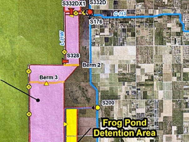
On April 29, 2021, I took a tour, with SFWMD staff, led by LeRoy Rodgers, Section Leader, Vegetative Management, 21 years; Christen Mason, Invasive Species Biologist, 7 years; and Brenda Mills, Principal Project Manger, Everglades Restoration, 23 years. Serious experience! The goal was to tour and learn about Frog Pond restoration, the C-111 project sites, and the 8.5 Square Mile Area. So what is the Frog Pond anyway? There’s no easy explanation, but I’ll try. The Frog Pond can best described as the “end of the road or the beginning of the road,” Ingram Highway that is. The end of the road for Florida City and the beginning of the road for Everglades National Park. Looking at the map provided by the SFWMD, one can see that the Frog Pond is the long yellow rectangle below; pink contains the C-111 South Dade Project of which Frog Pond is part; and the blue section at the top is the 8.5 Square Mile Area.So before we start jumping around…

Ecologically, this area is part of the Everglades Keys, the marl transverse glades, (where water once seeped through from the River of Grass) south of Miami.

-Landscapes and Hydrology of the Predrainage Everglades, page 49, 2011, McVoy.So how about today?

First, we must recognize the hard work of the public, the U.S. Department of the Interior,  the USACOE, the National Park system, and others. In the 1980s and 1990 all fought and achieved the Everglades  National  Park  Protection  and  Expansion  Act with the goal of protecting the eastern agriculture areas from flooding, but achieving more water into Everglades Nation Park. No easy task!

“To quote the book, page 257, River of Interests: “The  Interior  Department  and  the  National Park System agreed  that  acquisition  of Frog Pond was essential, claiming that it would restore freshwater to Florida Bay.” And as all has evolved, this is indeed being accomplished. Here is an excellent 2021 explanation from  SFWMD Chief District Engineer and Assistant Executive Director, John Mitnick.

“The Frog Pond Detention Area is a project in South Dade along the eastern side of ENP, and just southeast of the S-332D Detention Area.  It is part of the C-111 Spreader Canal CERP project.  Originally it was a detention area, meaning water was pumped into it and detained before it would evaporate or seep out into the groundwater table.  The purpose being to create a hydraulic ridge in the groundwater table (raise the groundwater elevation) to prevent groundwater and surface water from seeping out of ENP to the east.  Around 2016 the District undertook a project called the Florida Bay Project where we modified the detention areas to allow surface water to overland flow out of the detention cells into the headwaters of Taylor Slough after water had passed through the detention cells. This way it was a more direct hydration of the Taylor Slough.  Since it was completed, the project has been very effective at providing additional water to Taylor Slough.”

In its days as agriculture fields, the Frog Pond’s marl and limestone was mechanically ground up to create soil for crops. Though helpful for growing a menagerie of delicious things, this practice was very destructive to the ecology of the already drained lands.

Today the SFWMD has the lead on improving these lands. Christen Mason, Invasive Species Biologist and LeRoy Rodgers Section Leader, Vegetative Management, were proud to show me their restoration work.

The photo below is an excellent example comparing the invasive Napier Grass, on the right, which had totally taken over this area, and the restored rocky marl lands to the left-that have been “restored.”

Napier Grass is also called Elephant Grass and is a wicked invasive and very difficult to remove. Another invasive species, Burmese Pythons, are known to hide in it.

I.

-Left restored. Right full of invasive Napier GrassSo we can see that what was once a monoculture of invasive African Napier Grass is now a combination of native grasses and shrubs. A place for native birds and wildlife. This has taken decades. In some areas, pine trees were planted. Their pert green shoots explode against a blue sky. I hear chirps and singing insects everywhere! I keep looking for a frog, but don’t hear any.

-Christen Mason shows how the rock was ground up for soil-Native grasses and flowers have returned-LeRoy Rodgers holds a wildflower, and beautiful red bug -Pretty! Lots of butterflies!  -Gymnosperma glutinosum, Michelle’s favorite!-Calopogon tuberosus-a young slash pine reaching for the sky!-wild porter weed-a future forest-Beautiful native grasses and flowers-wild milkweed?-a cool water filled solution hole keeps life in dry times-note hammock in background. Lucky Hammock is most famous and a magnet for birds and bird watchers.-Christen poses for the camera. Surrounded by her creations!

II.

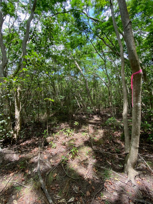
Next we drove north and hopped into a hammock. Frog Pond has famous hammocks especially in the west where lands were less disturbed. As we walked the rocky decline from the road, staff asked me if I was allergic to poison-wood or afraid of rattlesnakes. “Neither.” I replied. Proud my parents raised me like they did. Setting up my chair confidently, I took bite of my sandwich in the cool shade.

III.

The day was getting hot and we had to drive back to West Palm Beach, so next we jumped right along to the pump station!

Below is Structure-176, not too far north of the Frog Pond. This station pumps water that wants to go through those old marl transverse glades back into structures of the pink area creating  the hydraulic ridge Mr Mitnick wrote about. This ridge keeps water inside Everglades National Park- upper ground and surface water.

-S-176 -Water is sent back over the lands through the pump station. There are many in area!   Note the soil color and the solution holes!

We jumped back into the truck, and just when when I thought my trip couldn’t get any better,  the most wonderful thing occurred. As we approached I saw all these colored spots in the distance. I strained my eyes.

“Oh my gosh!”  I yelled.

Hundreds of wading birds had gathered. Wood storks, ibis, white egrets, blue herons, roseate spoon bills, and many others feasted, crammed together, on collections of fish and crustaceans.

I silently slid out of the truck, watching and trying not to disturb them. But as the trucks went past the birds lifted into the sky, squawking and flapping, then circling right back to their watery dinner table! I was in awe. “This is what it is all about,” I thought to myself. Like a description of Marjory Stoneman Douglas, a sea of birds rose from the Everglades and blocked out the sun. My eyes filled with tears… My hope renewed for our wildlife, our lands, and our waters.

-Birds fly!AWSOME BIRD VIDEO!


I wiped the tears from my eyes. Staff was moved as well. We knew we had just witnessed the best of Everglades restoration. It is working.

For the next leg, I drove with Brenda Mills, Principle Project Manager, Everglades Restoration. I learned she was not only an accomplished engineer but also an avid birdwatcher and had even chaired her local chapter of the Native Plant Society!

As we got out of the trucks for our final look around, I was told we were standing in the at controversial 8.5 Square Mile Area. Lands before me had been scraped and restored, piles of earth rose to the horizon. Behind me, tall Royal Palms blew in the wind. I could see an orange painted house through the Napier Grass, Australian Pines, and animals roaming.

The wind blew, the dust rose. “It will start raining soon.” Brenda said. “This landscape will look totally different then, you should come back.”

“Will do,” I said. “I want to see the waters tumbling into Taylor Slough.”  We laughed knowing this area can go from dessert like to Colorado River within hours. I finally knew something about the Frog Pond; I had seen and learned so much. I wished I could stay longer at this amazing place. We all looked at each other, smiling. I kept listening -just hoping that before I left, I would hear one frog chirping. I thought I did, but it must have been a goat. What a day at the Frog Pond!

-SFWMD’s Christen, Rory, and Barbara are doing great work! Thanks for the tour! -Invasive Nadier Grass and Australian Pines in the 8.5 Square Mile Area-An area adjadcent to the 8.5 Square Mile Area that is is slowing being restored. It was once entirely full of Napier Grass. The birds and animals are coming back. -one last photo before we drive home 🙂


“Eye on the Horizon,” Picayune Strand

Picayune Stand’s story is the story of Florida at its very worst, and at its very best.

In the 1940s and 50s, this 74,000 acres was logged of its giant cypress; in the 1960s, Gulf American Land Corporation “dynamited” canals, and roads were built for “Golden Gate Estates,” a Florida real estate scheme that never materialized. Gulf American sold plenty of swamp land, finally going bankrupt. This most beautiful of places was left  broken and ravaged. Times changed. The public fought for these lands, and in 2000, Picayune Strand became elevated as the first project of the Comprehensive Everglades Restoration Plan, or CERP. It is almost done…

On April 29, I visited this CERP project held and managed as Picayune Strand State Forest. Its stakeholders include the Florida Forest Service, U.S. Fish & Wildlife, South Florida Water Management District, U.S. Army Corps of Engineers, Florida Wildlife Commission, and Collier County. It was an inspiring field trip that I will share with you today.

8:00 am

SFWMD Lead Project manager, Joanna Weaver, and I drove for two hours to arrive at our destination in Collier County. Around a picnic table, we met ecologist, Mike Duever; Florida Forest Service biologist, Mike Knight; and Florida Forest Service fire expert, Sean Allen. As we all stood or sat around the table six feet apart, Mr Duever, thoughtfully gave his presentation. I listened intently. I think at first, he may have seen me a “lady from the city,” but I quickly won him over with my knowledge and love of plants and animals. After an excellent hour of intense slides and discussion, we paired off in trucks to take a tour. I was partnered with Mr Duever.-There is north Golden Gate Estates and south Golden Gate Estates. Picayune Strand State Forest is “south Golden Gate Estates” -south of I-75 (Alligator Alley).  North Golden Gate Estates (north of I-75)  is a neighborhood. On the map below, you can see the outlines of the roads now labeled as Picayune Strand State Forest south of I-75. The roads you see north of I-75 comprise the neighborhood of north Golden Gate Estates. The north was developed; the south became Picayune Stand State Forest. -Mr Duever’s handout demonstrates what was on the lands and is now removed, or in the process thereof.  First, logging trams in red; Second, canals in blue; and roads in grey. Mind you the property is 74,000 acres! -This is the back page of Mr Duever’s handout. Blue boxes equal the year/s canals were filled and thus the number of growing seasons for recovering vegetation and trees.  Yellow boxes equal the year/s roads were removed thus also the number of growing seasons. Some areas have had more time to heal than others. -In this handout, note three red squares at the top of the image. These red squares represent the three pump stations that are/will create sheet flow, restoring the hydrology and creating healthy habitat. Miller Pump Station, (far left), must meet flood protection standards for Lipman Farms on the east. This is being addressed now. Lipman Farms granted an easement for the building a protection levee. The entire project must not jeopardize flood protection for northern Gold Gate Estates, thus the U.S. Army Corps of Engineers portion of the CERP project, the gigantic pumps! -Below: Sean Allen of the Florida Forest Service loves his job. “Have you ever seen a panther?” I asked.” Absolutely!” He replies, looking in every direction. Picayune Strand is Panther Mitigation habitat for the state of Florida. This is panther country! 

I was very lucky to be paired up with Mike Duever. He has devoted his life to the restoration of these lands working first with National Audubon, then a long career with the SFWMD. He now works as a consultant for the SFWMD because no one knows the project like he does.

As he calmly took me over the bumpy roads, all the years, all of the ups and downs, all of the successes, all of the disappointments since 2000, I asked: “Are you ever upset that Picayune is not finished yet?”

“Jacqui,” he replied, looking at me with steel violet eyes, “restoration is full of “surprises.” What’s important is to do it the right way.” His glance veered off to the horizon.

By the end of the day, I felt I’d met John Muir himself.

We drove and drove. There were times it was just quiet.

I saw a giant eagle’s nest, deer, blue herons, alligators and beautiful wildflowers. We drove, got out, got in. There were miles of  filled-in canals and roads made one with the earth around them. The forest retuning…

Things weren’t perfect. Mr Duever spoke of an invasion of sable palms and the forestry service explained how the palms act as a middle story between the lower and upper stories, something these lands never had, sometimes promoting out of control wildfires that kill everything.

So much had been accomplished. So much was left to do…

It was complicated. Restoration is complicated. But like Mike Duever taught me that day, it is not about getting rattled by the “surprises,” it’s about the long view. It is about the horizon.

One day, not too far away, all of the giant pumps, not just two, will spread out the “flood waters” creating a sheet flow across the lands during the wet season. All of the trams, and roads will have been removed and the canals will all have been filled, leaving little pools for life to gather. The groundwater will synchronize; the cypress will come in where now willow stands. The wading birds will have thousands of areas to nurture their young. The panther will roam looking for deer and hog and the cry of eagle will echo through the cypress strands.

It will happen. Don’t look down. -Horizon.

-Mike Duever -Too many sable palms endanger the pines and cypress when fire strikes. Many must be removed.-Mr Duever holds a wildflower, Pink-Sabitia -Filled in canal -Removed roadbed. In time, vegetation will grow in.-Some areas of canals are left for water -Wildflowers and uplands-a giant blue bee! -Joanna assesses progress and things yet to come… -The history of Florida is written in these rocks piled high along the canals.-Mike Duever explains that this area was the greatest of the ancient cypress swamp. The willow he says is a precursor for its return. -A young cypress-A pond/canal adjacent to the former cypress swamp expands and contracts with the seasons. It is filled with fishes and gators. Look a snail! Life is retuning…

4:00 pm

-Final visit, the pump stations. Ominous! These things are huge and impressively spotless.

We meet Charles Hendrickson, a wildlife-loving engineer who works for the SFWMD. “I love the nature here. It’s getting to be more and more.” I count 12 alligators near the intake canal and six standing wading birds. He tells me he once saw flamingos! Next, taking his phone out of his pocket, Charles shows me a photograph of hundreds of white pelicans that visited the Merrit Pump Station just days days before. Incredible! As I wave goodbye, I notice Charles looking beyond.

Eye on the horizon…

Update: Picayune Strand/Audubon


The River Warrior Times ~Sunday, April 25th, 2021

Today, I begin a new blog section, called the “River Warrior Times.” This bi-weekly summary is meant for the general public who may not utilize social media. It is my hope, that this summary will help educate people as it is going to be a fast-paced late spring and summer.

ALGAE

This year, blue-green algae (cyanobacteria) was first spotted in Lake Okeechobee the week of April 5, 2021 and relayed to the SFWMD Governing Board by the public at the April 8 meeting. As the public continues to report these blooms, the Department of Environmental Protection has been testing for toxins. That’s helpful, but who is in charge of water quality anyway?

The Department of Environmental Protection (FDEP) is the lead agency for water quality for the state of Florida. The SFWMD assist the ACOE with opening and closing Central and South Florida gates and working to build projects. The Department of Agriculture is in charge of Best Management Practices for Agriculture. Circling back, the Department of Environmental Protection oversees Best Management Practices for cities and counties. I call this THE TRIANGLE. Not one agency is in charge. According to Florida Statutes,  the three agencies must work together. In 2019, Governor DeSantis’ Executive Order 19-12 laid out the order  for change to get these agencies working together. Since 2019, the state legislature and state agencies are charged to work to fulfill this order as the public pushes Desantis’ order or just their desire for clean water.

On April 10, 2021, the ACOE stopped discharging to the St Lucie River not because algae had been spotted, but because the Lake Okeechobee was evaporating so quickly the federally protected Everglades Snail Kite nests were at risks. Then, shortly after stopping for the Snail Kites, the ACOE needed to start discharging again because of torrential rains from storms that roared across the state filling up the lake again. By this time, the Department of Environmental Protection had found blooms at 121 parts per billion microsytin at S-308, the structure that opens from Lake Okeechobee to the St Lucie River, thus the Colonel’s decision was to send all discharge from Lake O to the Caloosahatee River (west) and none to the St Lucie. Why? Because of the very high level of toxic algae. Food for thought is also that the Calooshatchee has a wide marsh in front of its structure that filters toxins, the St Lucie’s structure  is in deep water that fills up with algae, there are no filters…

This is good news for the St Lucie. However, there are serous concerns here as there is red tide along the west coast. Water managers and experts on the west coast note that scientifically the present discharges do not exacerbate the red tide issue. I imagine some residents of the west coast do not feel this way.

There is a lot of work to do. It is my belief, that the SFWMD continues to work it’s part of the TRIANGLE to cleanse and send more water south most recently by removing the Old Tamiami Trail to allow more water to go to Everglades National Park and Florida Bay, and amazingly the  EAA Reservoir’s project partnership agreement  was approved with the ACOE last Thursday -meaning construction of the reservoir can begin.

Remember, for water quality to improve, THE TRIANGLE must work together: Florida Department of Environmental Protection; Florida Department of Agriculture; and South Florida Water Management District . 

OFFICIAL STATEMENTS

ACOE Operations Lake O statement, april 22, 2021

SFWMD statement: Ops_Position_Statement__Apr_20_26_2021

Yet another situation that occurred during this past week, announced on April 22, 2021, the ACOE halted a USGS Sediment study of the St Lucie River that would have required the S-308 structure at Lake Okeechobee to open. Why did they halt it? Again, because of the high toxic algae levels. Read their official  press release here.

PHOTOGRAHS

Ed and I last few over Lake O on April 16 seeing some algae along the eastern shore of Lake Okeechobee. Since that time and before, Mike Connor, Indian Riverkeeper, and Paul Gray, Florida Audubon, have displayed on the ground photos of much concern. Reinaldo Diaz, the Lake Worth Lagoon Riverkeeper was the first to spot on east coast and John Cassini, Caloosahatchee Riverkeeper on west.

-April 12, 2021, cyanobacteria at S-308 structure at Lake O that opens to St Lucie River (C-44). Photo Mike Conner, Indian River Keeper.-April 15, 2021, east shoreline of Lake O south of S-308, aerial Ed Lippisch. Algae was also north of S-308. -Photos shared on April 22, 2021 by Florida Oceanographic courtesy of Paul Gray, Florida Audubon, Pahokee Marina. Looking a lot like Central Marine in 2016.

SPRAYING

For three years, Mike Knepper of Martin County has been producing videos with a drone about the state spraying of vegetation in Florida lakes and waterbodies. These video are almost exclusively on social media and have started a movement that is “turning over the tables” as the Mr Knepper educates and inspires the public to push state agencies, particularly the Florida Wildlife Commission (FWC) to reevaluate motivations and outcomes of chemical spraying of floating vegetation, like water-hyacinth.

Recently, (4-18-21) the front page of the Stuart News ran an article by Ed Killer, entitled “Using Chemicals in Savannas Debated.” This article does not focus on Mike Knepper specifically but is a great guide to this issue.

Mr Knepper believes that there is a connection between the toxic algae and the chemicals that get into the environment as the chemicals cause the plants to die and float to the bottom and rot -causing more nitrogen and phosphorus to be released- thus fueling algae blooms. For example, a body such as the Savannas is connected to both the St Lucie River and Indian River Lagoon watersheds. The Kissimmee River is connected to Lake Okeechobee…

State agencies have been making headway with reflection, and redirection using more mechanical means etc, however; there is much, much more work to do.

I recognize the serious conundrum as an overabundance of floating plants can occur very quickly and explode into population that inhibits functioning flood control, endangering us all.

Mr Knepper says, “The plants? Why are they there ? This is Mother Nature trying to fix things! She is trying to take up all the phosphors and nitrogen through those plants!” 

Is there a better balance? Is spraying, indeed, adding to the toxic algae blooms? Until the next River Warrior Times. Keep fighting!

JTL


Protecting Bird Island from Kayakers and Lake Okeechobee Discharges

Bird Island, officially known as MC2, is a “no trespassing zone,” with ten large signs around it stating Critical Wildlife Area or (CWA). Recently, there have been complaints to the Florida Wildlife Commission from Sewall’s Point residents that kayakers have been getting on the island to view the birds flushing them from their nests. Terrible! Exposed chicks and eggs are a delicacy for crows and other predators. Bird Island is a state recognized breeding ground for multiple species of endangered and threatened wading birds. It is protected.

This past Wednesday, April 13, 2021, I accompanied the Florida Wildlife Commission and Martin County to do an official state bird count. There were over 300 birds mid-day and the number of nests will be estimated next week. The sound of the nestlings was unceasing with chicks begging for food as parents chirped and clapped back. Incredible! Chicks were hidden down in the mangroves but older ones were perched outside looking around, looking a lot like their parents. I was told it appeared to be an “average year.” It looked pretty good to me!

Today, I share photos and videos. Hopefully these will quench the thirst of those who may want to break the law. Bird Island can be viewed from outside the sign area, but not inside. FWC law enforcement is increasing visibility in the area and hopefully anyone out and about who sees a disturbance will call 1-888-404-3922. 

The most wonderful thing I learned was that since 2010, when I first met Ricardo Zambrero of FWC and the idea with the Town of Sewall’s Point, Nancy Beaver of Sunshine Wildlife Tours, and Martin County crystalized into a hard fought CWA-designation in 2014 ~ the beautiful pink roseate spoonbills have gone from rookery visitors to successful nesters! Last year over thirty roseate spoonbills were reported on the island, young and mature. I saw many the day of the count. Younger birds are lighter in color and one adult bird I saw sitting on a nest was almost red where body met wings.

This incredible place must be protected from curios visitors, just as we must protect if from polluted discharge waters from Lake Okeechobee!

Thank you FWC.

-Approaching Bird Island off South Sewall’s Point in the Indian River Lagoon-A menagerie of birds! A very diverse crew! Strength in numbers!-Wood storks, and roseate spoonbills-Magnificent frigate birds-Wood storks and frigate birds-Signs are posted around the entire island-Martin County works to protect the island from erosion caused by boat wakes and storms

-Wood storks on nests on black mangroves-Another view. Two large black mangroves died in Hurricane Irma in 2017. A huge loss of habitat.-JTL, SFWMD; Ricard Zambrero & Andrea Peyeyra, FWC; and Mike Yustin, M.C.-A pink rosette spoonbill against a blue sky-I think these are cormorants but they sure look like loons!INCREDIBLE VIDEOS

-Bird Island south side distant and up close

-Roseate Spoonbill flies overhead

-Many types especially wood storks, great egrets, and a juvenile  brown pelican

-Brown pelican flies from island – view of many birds

-East side of island rocks to protect from erosion. Oyster catchers have nested here!


-Earlier blog post about Bird Island and diversity of species. 

Haney Creek, Hidden in the Middle of Everything

My husband, Ed, has been out of town for a few days, so I decided to visit a place I haven’t come upon in a long time, Haney Creek. I had been pouring through 1940s Department of Agriculture aerials showing Martin and St Lucie counties in their pre-drainage/pre-development glory. What a mind-blower to see how much the landscape has changed! Nonetheless, there remain a few fantastic parks that allow us to connect with the past.

One of these, located right in the heart of Stuart, is Haney Creek or Haney Creek Trail. This gem of a park is over 157 acres and remains in as natural a form as possible. It contains very well marked trails, and the main path is only a short walk that can be made right on one’s way to the grocery store. Haney Creek is hidden in the middle of everything! It is peaceful and beautiful and a great reminder of our once wildlife full ~sand-pine, wet prairie, flatwoods habitat~ that in earlier days sprawled “everywhere.”

Looking at the aerial or walking along Haney Creek Trail, it’s easy to see how everything we put on our yards ends up in the river. Nature formed forests, sand dunes, ponds, and creeks so that all things found and find their way to the St Lucie…

On the 1940s aerial below, Haney Creek is located far south, just up from the “Y” of  US1 and the railroad track. Can you find it? If not, there’s a modern map within the photos that follow. Take a trip back in time with a mind set for today-it’s so easy and right in the middle of everything!  -Haney Trail, part of the Haney Creek Project, is located right off of Baker Road, next door to Felix Williams Elementary School. The main trail takes about twenty minutes to walk. I’m including some photos I took. My favorite is the prickly pear cactus-flower. Note the bee inside! 

Day 35 ~Discharges to St Lucie Stop, April 10, 2021

Documenting the Discharges 2021

On Friday, April 9, the Army Corp of Engineers announced it would halt discharges to the St Lucie River/Indian River Lagoon on Saturday, April 10. The Corp has been discharging from Lake Okeechobee since March 6th. Today Lake Okeechobee sits at 14.14 feet. Please read above link for details.

These aerials were taken by my husband, Ed Lippisch, yesterday, Saturday, April 10, 2021 at approximately 1:30 pm during an outgoing tide, from 3000 feet over the St Lucie River/Indian River Lagoon, and 1500 feet over Lake Okeechobee and the C-44 Canal.

There have been documented reports of algae near Port Mayaca at Lake Okeechobee as well as on the the west coast -April 8. Ed’s photos from April 10 reveal some algae in C-44 canal near the railroad bridge just inside the S-308 structure, but none was visible in Lake O near S-308 from the altitude of the airplane.

Ed, myself, and the River Warrior crew will continue flights documenting the visual condition of the St Lucie River/Indian River Lagoon. Always watching. Always sharing.

When we are not flying, you can follow along  electronically via my brother Todd Thurlow’s website eyeonlakeo. 

J&E

-Sandbar and barren (no visible seagrass) Sailfish Flats area of the St Lucie River/Indian River Lagoon. Visually, water is a mixture of blue and brown, mostly transparent, near St Lucie Inlet. -Discharges exiting St Lucie Inlet over nearshore reefs. It will take a few days for the river to clear up. -At Lake Okeechobee, Port Mayaca, S-308 Structure to C-44 Canal leading to St Lucie River-C-44 Canal at railroad bridge just inside S-308 structure. Algae visible on right side. -C-44 at St Lucie Locks and Dam S-80 Structure AKA “The 7 Gates of Hell.”

Information:

Florida Oceanographic Society  WQ Report “B” March 31-April 7, 2021

SFWMD Operations Position Statement April 6-April 12, 2021 Ops_Position_Statement__Apr_06_Apr_12_2021

Todd Thurlow’s website EyeonLakeO 

To learn more and sign a petition to stop the discharges:  RiversCoalition.org 

Closest to Home

Sometimes the most beautiful places, are the places closest to home. Savannas Preserve State Park, established in 1978, stretches more than ten miles from Jensen Beach to Ft Pierce containing the “largest, most ecologically intact stretch of freshwater marsh in southeast Florida.”

Ed and I usually visit through the Jensen Beach Boulevard entrance, but recently we entered at Walton Road. The beauty was remarkable!

According to the state’s handout, it was Lt. Benjamin Pierce who first used the term “savannah” to describe a series of ponds and marshes and more that he came upon during the Second Seminole War (1835-1842).

If you live near the Treasure Coast, this 5,400 acres offers a valuable close to home experience. Ed and I were there before sunset and even on a cloudy day the lighting was awe inspiring. A wonderful afternoon! Thank you to those who had the foresight to preserve these lands between the St Lucie River and Indian River Lagoon.-Ed takes photos of many small and colorful wild flowers and native plants.-Hello armadillo!-My arms are not even the length of a brown pelican’s wing span!-Ed is shorter than a sandhill crane!-Now this is a great classroom!Savannas Preserve State Preserve Park, Florida Parks System.


28 Days After the Discharges~2021

Documenting the Discharges, Saturday, April 3, 2021.

Since last week, the ACOE has lowered discharges to the St Lucie River from 500 cubic feet per second to 300. The lake is now down to 14.44 feet from over 16. Blue-green algae has been spotted in the C-44 canal near S-80 at St Lucie Locks and Dam. This canal connects Lake O to the St Lucie River and blue-green algae is always of concern as reported my Max Chesnes of TCPalm. Ed and I saw no algae at S-308 on Lake Okeechobee from the air. The water does have an odd hue-perhaps due to wind. We did not get over S-80 due to weather conditions.

This go around, the ACOE began discharging on March 6, 2021 to the St Lucie River, so yesterday, when these photos were taken it was 28 days after the discharges. The aerials were taken from about 3000 feet, at approximately 3:30pm, on an outgoing tide. Conditions were  windy, cloudy, and all  waters were stirred-up.

Please note federal, state, and local links on subject following  photographs.

~Wishing all a Happy Easter and Spring time! See you next week. Ed & I will continue to document the discharges.

J&E

Running images of S-308 at Port Mayaca, Lake Okeechobee and over the St Lucie River/Indian River Lagoon near Sewall’s Point the dividing peninsula of these waters-merging at the Crossroads and Sailfish Flats near the St Lucie Inlet. Photos Ed Lippisch.

USACE to reduce Lake Okeechobee releases beginning April 3, 2021.
U.S. ARMY CORPS OF ENGINEERS, JACKSONVILLE DISTRICT
Published April 2, 2021: (https://www.saj.usace.army.mil/Media/News-Releases/Article/2560023/usace-to-reduce-lake-okeechobee-releases-beginning-april-3/)

-Notice of Algae (https://www.saj.usace.army.mil/Missions/Civil-Works/Navigation/Notices-to-Navigation/Notice-to-Navigation-2021-007-Okeechobee-Waterway-Algae-Notice/)

(B) Florida Oceanographic Society WQ Report March 31, 2021:(https://mailchi.mp/floridaocean/waterqualityreport2021-1215216?e=0a1cb67484)

South Florida Water Management District operations recommendation to the ACOE March 30-April 5 2021. Ops_Position_Statement__Mar_30_April_05_2021

SFWMD March 31, 2021 visual water levels update and newsletter sign up.

Martin County Health Department Blue Green Algae St Lucie River, April 2, 2021.

Canals killing the St Lucie River-

SFWMD canal and basin map. C-44 canal is the canal most southerly in the image connected to Lake Okeechobee. Note S-308 at Lake O and S-80 at St Lucie Locks and Dam.

A Captains’ Introduction to the Shark River!

-Captain Chris Wittman & Captain Daniel Andrews of Captains for Clean Water w/JTL & Ed. Shark River to Shark River Slough transition zone adventure, 3-24-21. Photo Noah Miller.I have had this fascination with finding the Shark River. Maybe it’s the visual; maybe it’s the promise of more water flowing south; maybe it’s because I keep having a hard time finding it…

Twice I had tried. Once, on a boat trip from Flamingo and another flying over with my husband. In both cases, really, the river eluded me. “How can something so big, be so hard to find?” I thought to myself. Well, some of that may be related to the complex changes humankind has made to the Everglades system. It took a day led by Chris Whitman and Daniel Andrews of Captains for Clean Water to meet this elusive river “face to face,” and even begin to understand it.

Before I share the story, I am taking my favorite book off the shelf: Landscapes and Hydrology of the Predrainage Everglades. These images, on pages 46 and 47, compare the hydrology of the Everglades south of Lake Okeechobee from 1850 to today. Even without clicking to study the image, one can see the changes. The Shark River, near the bottom of the system, receives considerably less water today than in its past. The River of Grass south of Lake Okeechobee, which includes Shark River Slough, has been blocked by roads, cut by canals, amputated in the north by the Everglades Agricultural Area, and pushed west from encroaching eastern development.  A modern picture from the National Park System reveals what remains today inside of Everglades National Park and shows the connection of the Shark River to Shark River Slough. My goal was to meet this river and to do so my husband, Ed, and I met the Captains in Flamingo at Flamingo Marina. We were to cross through Whitewater Bay, then enter the “Little Shark River” and next, come face to face with the Shark River itself!

Ed and my morning began at 3:00am. I don’t believe I have ever gotten up this early. The alarm rang and Ed excitedly said: “Time to get up! ” 

“Already?” I replied, stuffing my head under the pillow.

After getting ready, we jumped in the car driving south from Stuart in total darkness to Homestead and entered Everglades National Park. We were to meet the Captains at 8:00am. We were on time, but Ed likes being early.

Slow down Ed! You might hit a panther! I exclaimed.

“I’m following the speed limit Jacqui.” Ed replied. “Go back to sleep.”

The sun was coming up and a menagerie of wading birds gracefully glided overhead. The sun shone through their feathers in hues of oranges and pinks. “This is beautiful.” I said, starting to wake up.

“You should try getting up early more often-we could go fishing together.”  Ed joked.

I rolled my eyes, “I would only get up this early to meet the Shark River, not to catch fishes!”  We laughed.

We saw the sign for Flamingo. We had arrived.

The Captains were waiting; boat already in the water. After quick “hellos,” we waved goodbye to a sleeping crocodile and headed up the Buttonwood Canal to Whitewater Bay. It was so exciting! Finally, I thought, I will indeed meet the Shark River!

It was chilly but no wind. The water was like glass. There was no one else.

-Captain Daniel Andrews and Noah Miller in the Buttonwood Canal leading into Coot Bay.-JTL and Captain Chris Wittman.-What a cool decking! “Send the water south!”-Ed smiles for the camera.Suddenly we stopped.

“Is this Whitewater Bay?” I asked.

Chris nodded his head up and down and climbed above the engine. I noticed he was wearing no shoes, just socks.

“What’s he doing?” I whispered to Ed.

“He’s sighting tarpon. Shhh.”Suddenly I saw a tremendous splash in the distance! A rolling silver monster of a fish. It was spectacular! Never in my lifetime had I seen a jumping “silver king.”

I watched. I listened. It was magical. And like the Shark River, the tarpon stayed just out of reach, remaining a mystery….

We continued on..

We traveled quite a long way, many miles, first hitting the Little Shark River and then the Shark River itself. Some maps like the one below show it all as the Shark River.

“Chris looked at me through reflective glasses. He smiled. “Here you go Jacqui, this is it. The Shark River.”

“Oh my Gosh finally! I exclaimed standing up.“Hello Shark River! I dragged my fingers in the clear, brownish water smiling from ear to ear.

It felt like we were in Africa or some far away land. The Captains were taking us deep into the northern reaches of Otter Creek and  Rookery Branch  as displayed on page 109 of The Everglades Handbook, another excellent publication. Chris said, “Not only are you going to meet the Shark River, we are going to take you to were its connection meets Shark River Slough.” When we arrived at the end of the branch, the waterway got thinner and thinner, the plants began to change. We stopped when we could go no further. Captain Daniel explained that we were in the “transition zone.” Shark River Slough was just north of us, on the other side, where the vegetation would become more marshy. Fresh water flowed through here. I could see coco-plum, like in my yard,  growing right next to mangroves. The vegetation was mixed and different. Daniel discussed the history and how the mangroves have grown much further north since around 1920 because of the lack of fresh water. I looked down. It was very shallow. I could see limestone, marl or some type of rock. What looked like peat and leaves lie on top. The water was clear. Fishes were darting about. I could see the water slowly flowing…

We were at the interface, the meeting place of river and slough. We talked about Everglades restoration for a long time noting that the water now wasted to tide and destroying the Northern Estuaries from Lake Okeechobee once flowed massively south through this area into Florida Bay. We talked about the hyper-salinity and seagrass die-offs in Florida Bay due to the lack of fresh water. Yes, recently, and in 2015, starting in the 1980s. What a conundrum. We must continue to work to send more water south!

-Captain Chris teaches us about the transition zone.-Transition zone between river forks and Shark River Slough. Blue dot is location of the boat. Line above is Tamiami Trail east of Miami. Before heading home, the Captains took us in the opposite direction to see Ponce de Leon Bay, where the Shark River and other rivers carry the water of Shark River Slough into Florida Bay and the Gulf of Mexico.

Along the way, we passed a mangrove forest that contained giant remnant black mangroves the size of oak trees! I even saw a tree snail. I had never seen such a big tree snail either!

All the way home, I felt renewed.

I will never forget this special day. The day Ed and I had a Captains’ introduction to the Shark River -and so much more!  Ed and I are forever grateful.

With every experience like this I can see, really see, what needs to be done to send more water south, to save the estuaries, and to replenish Florida Bay. Having met the Shark River, may just have been the ultimate inspiration.

-Ponce de Leon Bay mangrove forest. -Hugging an enormous ancient black mangrove.-An Everglades tree snail!-Captain Chris overlooks Ponce de Leon Bay. -Heading home! -Back on land at Flamingo Marina. A final farewell selfie. -Crocodile loves the comfy boat ramp.-Ospreys feed their rapidly growing young. All animals of the Everglades need flowing fresh water from Lake Okeechobee to Florida Bay. We must continue to send more water south!

Videos: 1 & 2  on the way to the transition zone of the upper forks towards Shark River Slough.

1.

2.


3.  Approaching Ponce de Leon Bay that opens into Florida Bay and Gulf of Mexico.


21 Days After the Discharges~2021

-St Lucie River/Indian River Lagoon March 27, 2021. Photos Dr Scott Kuhns.As we all know, the ACOE began discharging 500 cubic feet per second of Lake Okeechobee water to the St Lucie River on March 6, 2021. At this time the lake was at 15.23 feet. There were/are great concern as wet season is rapidly approaching…

Since March 6th, Ed and I have been documenting the discharges for 2021 so that visually we have a record of changes as time goes on. We have been doing this since 2013’s Lost Summer that spurred a River Movement that turned over the tables, has evolved in many directions, and continues to work on changing Florida water policy today.

In today’s blog post it not Ed and I, but friend Dr Scott Kuhns who is documenting the discharges. Unlike me addicted to my iPhone, Scott uses a professional level camera. Wow!

Presently, Ed’s plane is in the shop so I am very grateful to pilot Steve Schimming and pilot/photographer Kuhns, for filling in and taking these excellent aerials yesterday, March 27, 2021 around 10:30 am. It was a full incoming tide with full moon rising today, March 28th. The water looks beautiful. The photos even reveal the near shore reefs!

Such conditions can push back against 500cfs coming from S-80 as presently there are no discharges from canals C-23 and C-24 because it is bone dry right now. Lake Okeechobee is evaporating and is now at 14.56 feet. This remains high. Please view the information I have included at the end of this blog for details of conditions from Florida Oceanographic as well as SFWMD & ACOE content. No discharges are good discharges but it is wonderful to see these blue aerial photographs as Spring is sprung and wildlife is procreating! Hopefully oysters, fish, and bird life will have a good season and mature before summer storms are arrive.

In closing, thank you Scott and Steve for a classic view from the Cub also known as the “River Warrior II;” so good to see her! She was and remains the “original!

~Documentation St Lucie River/Indian River Lagoon, March 27, 2021. Scott Kuhns & Steve Schimming reporting from the Piper Super Cub.

-Over nearshore reefs off Peck’s Lake, all photos by Dr Scott Kuhns.-Wide views St Lucie Inlet State Park and St Lucie River/Indian River Lagoon. -Sailfish Point and St Lucie Inlet note near shore reef! Beautiful! Also damaged by discharges as documented by Harbor Branch. -Great shot of nearshore reefs off the St Lucie Inlet.-Looking towards Stuart and the Crossroads over St Lucie Inlet. -Part of Sandbar area. Could that be seagrass coming up?-Opening to Jupiter Narrows. Note dredge. -Sailfish Flats still devoid of seagrass.-Sewall’s Point between St Lucie River on west and Indian River Lagoon on east-Over south Sewall’s Point looking towards Stuart -Hell’s Gate, bottleneck between Stuart and Sewall’s Point, St Lucie River.-Witham Field, Stuart and looking west.-Below: Over Langford Landing that still looks like an atom bomb hit after five years of development-after they tore down all of Francis Langford’s beautiful trees and flattened the historic bluff that pirates used to use for an outlook. I hope they plant some vegetation soon! Aggg!-Roosevelt Bride over St Lucie River.-Looking west towards the Roosevelt Bridge, Palm City and Rio in foreground. South Fork and Beginning of North Fork visible-Another view of Langford Landing with no trees  after five years, the former home of the famous and generous Frances Langford.-Langford Landing marina is filling up and is located at the merging point of north Sewall’s Point and Rio. This would look a lot better with some stately trees.-Here we see the Harborage Marina near the Roosevelt Bridge in Stuart/Rio. River water is not blue here as flushing is poor compared to St Lucie Inlet. The St Lucie has been ravaged by discharges from C-44, Lake O, C-23 and C-24 beginning in the 1920s.-Looking west over the Roosevelt Bridge note C-23 Canal in distance that separates Martin and St Luice County. Over-drainage is the root of Florida’s water problems today. As a farmer once told me, “We spent 100 years taking the water off the land, and we’ll spend 100 years putting it back on…”


Previous Posts Jacqui & Ed:

Day Before the Discharges, March 5, 2021

7 Days After the Discharges

15 Days After the Discharges: https://jacquithurlowlippisch.com/2021/03/22/15-days-after-the-discharges-2021/

Helpful Recent Information:

Florida Oceanographic water quality report grades a “B” for March 24, 2021 click here.

ACOE March 26, 2021 press release about reduction in Caloosahatchee Lake O releases, St Luice to remain the same click here.

ACOE, Lake O on 3-28-21, at 14.56 feet: https://w3.saj.usace.army.mil/h2o/reports.htm

SFWMD staff’s recommendation to the Corps regarding Lake Okeechobee operations for the period March 23 to March 29, 2021: Ops_Position_Statement__Mar_23_29_2021