Monthly Archives: April 2014

A Summary, 2013/14, the Year of the Indian River Lagoon

Last year, the people rose up giving the Indian River Lagoon her voice, and things will never be the same. (Drawing of Earth and water by Mary Thurlow, 11.)
Last year, people rose up giving the Indian River Lagoon her voice. Tallahassee has heard. (Drawing of Earth, people and waters by River Kidz member, Mary Thurlow, age 11.)

“Let us throw off everything that hinders, and run with perseverance, the race marked out for us…” Hebrews 

We might still be a long way from the finish line, but no one can say that the Indian River Lagoon hasn’t hasn’t been “heard.”  In 2012, few state legislators, not even the Governor, sitting in his chair in Tallahassee knew what, or even where, the St Lucie River/Indian River Lagoon was…  Today literally, “everyone” in Tallahassee knows about the, dying manatees, sick dolphins, toxic waters, the disappearing seagrasses, and deadly releases from Lake Okeechobee. On top of that “Tally” is watching the IRL positioned to walk away with a large chunk of the pie, a pie that others wanted too. Others who had been fighting longer than the IRL and were very much know by name… Remarkable.

image002

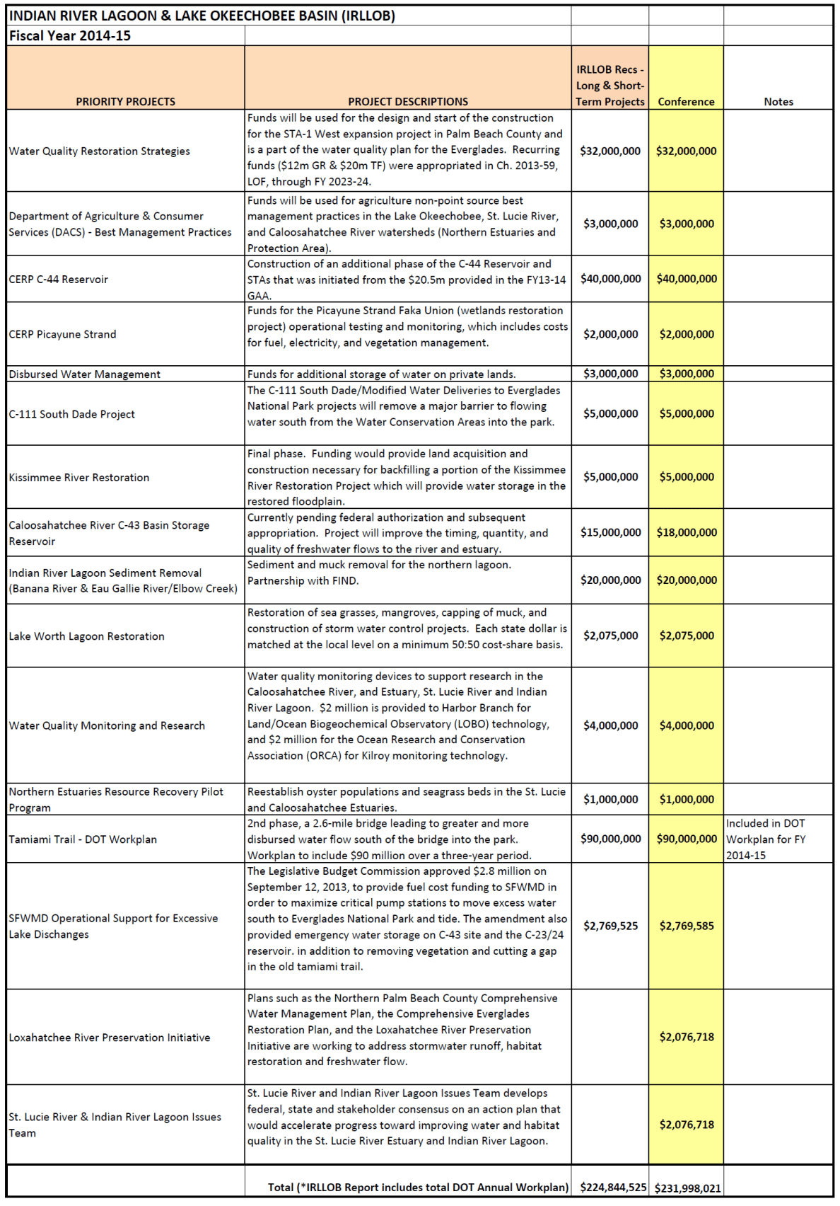
(Specifics of Negron’s Senate/House negotiated IRL/L.O. 3-year budget for 231.9 million dollars. This “recommendation” must still go before the Governor’s pen.)

How did this happen? How did the Indian River Lagoon get so well known so quickly?

This happened because the the people, River Kidz, and local officials of Stuart, Port St Lucie, eventually all eight counties along the lagoon, rose up, demanded change, exposed  health, safety, and moral issues, and then the local press, Scripps, took that flame of the people, threw kerosine on it, and has continued to keep the fire going. State and Congressional politicians along with state and federal agencies, usually free to do whatever they pleased, were taken off guard, suddenly their constituency was watching where officials got their money, how they were voting, and if they were supporting the lagoon.

Senator Joe Negron listened and made the Indian River Lagoon his first priority creating the budget list above, held a Senate Hearing that took the topic “viral,” possibly under-cutting  his Senate presidency because of his outspoken support, and then proceeded to tell the ACOE they needed to give up their control of the lake and that  they were “killing us;” Rep. Gayle Harrell made a memorial in DC her “top”priority; newcomer Rep. Larry Lee voted against party line for the sake of the lagoon; and freshman Rep. Mary Lynn Magar passed out bottles of muck ridden toxic river water and aerial photo booklets to her  colleagues, Rep. Debbie Mayfield called her closest contacts… At the federal level, Congressman Patrick Murphy did every single thing possible to familiarize the ACOE leaders with the C-44 IRL project, and even invited the public to DC for a special meeting. In walks Nancy Pelosi, and then this bipartisan group helps  get the WRDA (Water Resources Development Act) bill passed in the US House of Representatives where usually people can’t make a decision to save their lives.  Holy Cow!

OK, let’s pull back for a moment, because I come from a group of erudite and very skeptical river supporters. And although I am excited, I am not wearing rose colored glasses and never have. I know politicians can dance like marionettes  when they need to; I know that a lot more has to be done, like a flow way south;  I know that if it starts raining intensely tomorrow and doesn’t stop, a repeat of the “Lost Summer” will happen all over again. But Karl…Michael….the others….even you, the harshest, most honest critics, have to admit that the end of 2013, and so far 2014, has been one remarkable year. Less than a year actually…

Just May 8th of last year, the releases from Lake Okeechobee began releasing for 5 months, and set off a series of events that galvanized public outcry. Thousands of people rallied at the locks and shoreline; social media whipped the situation to a frenzy,  and today we are  still today talking about it, fighting for it,  and defining ourselves and our children by it. There are no social, age or economic boundaries. It is all of us. We are making history.

IMG_5787

Yes, a great disappointment, the ACOE’s recent denial of CEPP (Central Everglades Planning Project) into the WRDA Bill last week is a huge setback, but the Army Corp of Engineers has  forgotten something. When passions are repressed, they only get stronger.

This Saturday at 9 AM, locals have organized a “Funeral Services for the Lagoon” at St Lucie Locks and Dam in response to the ACOE’s inaction. (Go to Facebook for information.) Here again locals will plead  their case to “send the water south.”

When I reminisce about the past year and even present, I am reminded of Dr Suess’ famous children’s book, Horton Hears a Who. The story is about the miniature city of people who live on the speck of dust. After being lost, Horton the elephant and the other animals hear the screaming “We’re here!” “We’re here!” of the tiny people of Who-ville, and agree to protect them. But they wouldn’t have protected them if they did not hear them. Remember?

Like the story, the Indian River Lagoon has finally been heard! Be proud of this. It is a huge accomplishment. We are certainly not yet at the finish line, but let’s be happy that 2013/14 has been, “The Year of the Indian River Lagoon,” and that everyone knows our name!


Non-Native Species Along the Indian River Lagoon

Common orange rat snake and Knight Anole in a life or death struggle, Sewall's Point. (Photo by Nina B, 2014.)
Common red rat snake and knight anole fight to the death on the back porch, Sewall’s Point. (Photo by Nina Barsik, 2014.)

I believe that all animals are God’s creatures and I try to be kind to every single one, even snakes, lizards and ants. I drive my husband crazy, and he rolls his eyes if I scold him for killing a fly,  but I have been this way since I was a kid. All of the animals are my friends. I always wanted to be Snow White and have the birds land on my shoulder and talk to me. So far, the cardinals in my yard sometimes come close when I put out their sunflower seeds, but that’s about it.

Upon seeing this photograph yesterday, I wanted to share because if nothing else it reminded me that we are not the only ones fighting for our lives here along the Indian River Lagoon!

This photo, taken in Sewall’s Point, is of an red rat snake, a native, and a knight anole, a non-native, that according to the Florida Wildlife Commission has lived and bred in our area for around ten years. I have had  both species  in my aquarium at one point or another if they were injured to rehabilitate;  from what I was told, these two in the photograph were in a very healthy death grip, until one “won” of course….

By the way, in case this photo  freaks you out, snakes are great natural pest control of especially rodents; they will not attack a well cared for “Fido,” so please don’t kill them.

As afar as the knight anole, non-native species are not a problem unless they start to take over native  species to the point that the entire eco-system radically changes. For instance, many of you may be familiar with lion-fish which are now invading the lagoon and according to Harbor Branch Oceanographic kill/consume about 67 % of all life around them; or pythons in the everglades eating, deer, panthers, and alligators and now becoming the top predator. This is a problem… At the end of the day, it is usually humans that bring the animal into the non native area by releasing pets.

The Florida Wildlife Commission defines non-native animals as “exotic” saying:
“Exotic species are animals living outside captivity that did not historically occur in Florida. Most are introduced species, meaning they have been brought to Florida by humans. A few of Florida’s exotics arrived by natural range expansions, like cattle egrets which are native to Africa and Asia but flew across the Atlantic Ocean and arrived in Florida in the 1950s. Several common nonnative species, like coyotes, armadillos and red foxes, were not only introduced by humans but also spread into Florida by natural range expansions.”

So let’s know our environment, please be kind to all animals,  and let’s all help nature’s balance by not releasing exotic pets into the wild along the St Lucie River/Indian River Lagoon.

Who won? I knew you were wondering about that…the snake!

Florida Wildlife Commission/FWC: (http://myfwc.com/wildlifehabitats/nonnatives/exotic-information/)

FWC Knight Anole: (http://myfwc.com/wildlifehabitats/nonnatives/reptiles/knight-anole/)

FWC Red/(Orange) Rat/AKA “corn snake” Snake:http://myfwc.com/wildlifehabitats/imperiled/profiles/reptiles/red-rat-snake/)

_______________________________________________________

2-11-15:  Just to follow up and note how small the world is– as well as how much can happen through social media… a Harvard Professor and Curator of Herpetology, at the Museum of Comparative Zoology, at Harvard University, Johathan Losos, saw this IRL blog post above on the invasive Knight Anole and native Rat Snake fight in Sewall’s Point. He then got in touch with me, spoke to the woman at whose home this occurred, and  published his own blog post for his Herpetology community. Read his blog here! Thank you Dr Losos! (http://www.anoleannals.org/2015/02/09/knight-anole-vs-red-rat-snake-who-will-win/)

Understanding How to Derail All Aboard Florida Along the St Lucie River/Indian River Lagoon

The movement to derail all Aboard Florida is gaining momentum. (Photo Peter Schmidt, United Yacht Sales . (Photo Jacqui thurlow-Lippisch)
The movement to derail All Aboard Florida is gaining momentum. (Photo of Peter Schmidt, owner, United Yacht Sales. Peter and his wife Anne attended the Florida NOT all Aboard Flotilla. (Photo, Jacqui Thurlow-Lippisch.)

Yesterday morning, over 100 boats gathered at the Roosevelt Bridge in Stuart, forming a flotilla in opposition to “All Aboard Florida’s” high speed train which would close the bridges over the St Lucie River for unacceptable periods of time. A large red sign on Angie and Jeff Swenson’s boat read NO TRAINS.

photo 2

(Above photo by Ed Lippisch and Scott Kuhns)

Just in case you are not familiar with the project,  I thought today I would describe the basics of how All Aboard Florida’s father company, Fortress Investment Group, is structured, as the best ways to garner change, is to understand “how it works.”

We here in Martin County have certainly learned this with our St Lucie River/Indian River Lagoon Issues. In fact, the river issues have  already galvanized our community so it has not been that difficult to do the same for the train.

In my opinion, in order to derail All Aboard Florida, there are two options: to stop the line at its source, (Orlando) or to get it to “go west.”

To begin with, one must understand the basic structure of Fortress Investment Group of which “All Aboard Florida” is part. Fortress consists of four divisions: 1. Flagler-the real estate entity; 2. All Abroad Florida-supposedely the first “private” rail system in America; 3. Flagler Global Logistics-a logistics solution group; and 4. ROW (Right of Way) Management Services.

Fortress Investment Group: (http://www.fortress.com/Default.aspx)

All Aboard Florida (http://www.allaboardflorida.com)

Keep in mind, Florida southern rail lines now consist of three main parts: 1. the Cocoa/Melbourne area to Orlando line or Highway 528/the money for the Orlando Train Depot; 2. the Florida East Coast Railway tracks  that run from Jacksonville to Miami (the ones that go through Stuart) and 3. the CSX tracks that run west from West Palm Beach to Orlando. 

Now we must go back in the story a bit to get perspective. Last year, “All Aboard Florida” was able to secure the right of way along Highway 528 from approximately Cocoa to Orlando, to lay tracks to the Orlando airport. Fortress had to get a “right of way” from the Florida Department of Transportation to lay tracks in order to do this.  On top of this a bit later,  they were granted funds from the state of Florida to build a rail “depot” station at Orlando International Airport. This Orlando element is actually the “All Aboard Florida” piece even though we keep using it for “down here.”

The second part of the puzzle, the Florida East Coast Railway tracks, are historical and owned by Fortress, these tracks run from Jacksonville to Miami. There is nothing we can do about this, except be vocal or rip the tracks out which would not be a good idea.

And last are the CSX tracks. These tracks run out west away from “us” starting in  West Palm Beach and going to  Orlando; they are not  owned by Fortress. They are owned by another company called CSX, a cargo company.  At this point, there is no plan to purchase these tracks to send the All Aboard Florida project west to Orlando rather than through our eastern cities.

photo tracks

Securing ROW Highway 528: (http://www.progressiverailroading.com/passenger_rail/article/All-Aboard-Florida-secures-right-of-way-for-OrlandoMiami-passengerrail-project–37920)

Funding of Orlando Depot: (http://articles.orlandosentinel.com/2014-02-17/news/os-orlando-international-scott-20140217_1_all-aboard-florida-rick-scott-depot)

In summary, it is clear that the only reason All Aboard Florida is “going south” at all is because the state of Florida has supported Fortress Investment Group with the Cocoa to Orland piece, Highway 528,  and the building of the train depot in Orlando.  This is the piece/s that must be derailed. I am not sure how to achieve this, however, if the northern piece goes kaputt so will the journey south-east. 

Train travel is actually a great benefit for people and the environment, having lived in Europe, I can attest to this. Nonetheless, the present All Aboard Florida plan is unacceptable with its negative effects on property values and businesses west of the Roosevelt Bridge, particularly  the marine industry. Let your local delegation know how you feel. We are important to them, between the river and the train, we have a lot to  say about their reelection, and believe me they need us.

LOCAL DELEGATION TO WRITE:

Fl. Senator Negon: negron.joe.web@flsenate.gov

House Rep. Harrell: gharrell@gayleharrell.com

Fl. House Rep. Magar : marylynn.magar@myfloridahouse.gov

Fl. Governor Scott: rick.scott@eog.myflorida.com

US Congressman Murphy: congressmanpatrick.murphy@mail.house.gov


The Coral Strand’s Fishing Riches; Today’s Sailfish Point, Along the Indian River Lagoon

1950 map by Ben McCoy of the "Coral Strand" and its riches,  today known as Sailfish Point.
1950s map of Hutchinson Island’s “Coral Strand.” Today, known as “Sailfish Point.” (Map, Ben McCoy, courtesy historic archives of Sandra Henderson Thurlow.)

How romantic, the “Coral Strand…” Like a string of pearls the riches of Hutchinson Island’s coast strung along the blue waters of the Atlantic and Indian River Lagoon. The crowing jewel, today,  known as Sailfish Point.

The above promotional map by Ben McCoy, brother, of the infamous rum runner, Captain Bill McCoy, highlights some of our area’s best features, most interesting history, and even an excerpt from a novel by Faith Baldwin:

” It was a long jut of land running into the water, upon one side was the ocean, upon the other, an inlet forming a small quiet bay. It was colored like a lithograph, strong blinding colors. The beach was so white that it dazzled, water and sky so blue they seemed unreal…”

If one looks closely at the map, fish of the area are listed around the point: Blue Fish; Sheepshead; Bass; Snapper; Pompano; Spanish Mackerel; and Tarpon everywhere…the Indian River is not noted just as the” Indian River” but the “Famous Indian River,” for fishing of course!

IMG_3626


The publication notes that five presidents, Arthur, Cleveland, Roosevelt, Taft, and Harding,  as well as Joe Jefferson, beloved  disciple of Izaak Walton, fished these waters as “who indeed among fisherman has not heard of the famous St Lucie Region, rendezvous for more than half a century for anglers  from all over the world!”

Believe it or not, according to The History of Martin County, the McCoy’s land, today’s Sailfish Point, was listed for $25,000.

It is fun to visit the dream like past, but soon or later, reality always sets in. In the 1950s the Coral Strand was sold to eccentric entrepreneur and Florida Oceanographic Society founder, James Rand, for its limited development the name was marketed as “Seminole Shores.” Later in the 1960s, the the Hutchinson Island property was sold by Harvard University to a group of Boston investors and eventually to Mobil Oil who legally tore the mangroves from the land, scared off the mosquitoes and filled it. Eventually, in the 80s the land was developed as exclusive “Sailfish Point.”

According to Dr Grant Gilmore, most famous for his long career at Harbor Branch Oceanographic, the waters/seagrasses surrounding Sailfish Point, the old Coral Strand, are truly the most diverse in the North America with over 800 types of fish, often growing baby fish, documented in these waters.

It is a crime that during rainy season, the Army Corp of Engineers often releases water from Lake Okeechobee exacerbating the pollution from our local canals killing the seagrasses in these waters, thus fish habitat destroyed. Last year, in 2013,  according to Mark Perry of Florida Oceanographic, approximately 85% of the seagrasses were destroyed.

Yes, this has happened many times, but one day, it may not come back.

For history, for today, we must fight to protect our “Coral Strand,” and our pearl, our incredibly bio-diverse waters…

___________

The History of Martin County can be purchased at the Historical Society of Martin County: (http://www.martincountyhistoricalsociety.com)


Understanding High Bacteria Levels in the St Lucie River/Indian River Lagoon

Clear water off of the Stuart Sandbar, but is it clean?
Clear beautiful water off the Sandbar, Stuart; but is safe to swim? (Photo, Jacqui  Thurlow-Lippisch, St Lucie River/Indian River Lagoon, 2012)

Enterococcus: Bacteria normally found in the feces. Two types, Enterococcus fecalis and Enterococcus fecium, cause human disease, most commonly in the form of urinary tract and wound infections. Other infections, including those of the blood stream (bacteremia), heart valves (endocarditis), and the brain (meningitis) can occur in severely ill patients in hospitals. Enterococci also often colonize open wounds and skin ulcers, and are among the most common antibiotic-resistant bacteria. Medicine-Net

*The Martin County Health Department tests for Enterococcus (E) in area waters: According to their interpretation, 0-35 cfu of E./100 ml  river water =GOOD; 36-104 cfu E/100 ml river water=MODERATE; and 105  cfu E./ml River water is POOR (“cfu” relates to number of viable cells per milliliter.)

In November 2012, some members of the public were worried that the Martin County Health Department (MCHD) did not have enough support. Due to the pushing of a few members at a Rivers Coalition meeting, Senator Joe Negron, during the legislative budgeting process, added specific funding for MCHD to sample three new sites weekly. In turn, with input from the Rivers Coalition and the help of Bob Washam of the MCHD, the three test locations were chosen and the public began regularly checking bacteria levels in the St Lucie River/Indian River Lagoon on the MCHD website. 

Before the senator intervened, the sites being tested in the river were the Roosevelt Bridge; the Jensen and Stuart Causeways, and the north fork of the St Lucie River in St Lucie County. 

The new test sites included Bessey Creek, close to the mouth of the C-23 canal, in Palm City;  Leighton Park, at the base of the Palm City Bridge;  and Sandsprit Park, near the Manatee Pocket in Stuart, close to the inlet. The Department of Environmental Protection also conducted/s periodic testing.

In early June of the 2013, the bacteria numbers really spiked. This occurred after heavy rains caused storm water to run through local canals C-23, C-24, and C-44 into the river, as well as polluted fresh water discharges from Lake Okeechobee through C-44, that had begun on May 8, 2013 by the Army Corp of Engineers.

The areas waters were looking dark and ugly, and most of the river was off limits to the public due to high Enterococcus levels.  By mid June, there were a number of reports from people that had visited the Sandbar, located just inside the mouth of the St Lucie Inlet, that they and their children were feeling ill with stomach aches and diarrhea after contact with the water.

photo of algae

(Photo of water in St Lucie River two miles from Sandbar w/ high bacteria and toxic blue green algae, photo by Jenny Flaugh, July 2013.)

Because of the popularity of the Sandbar area and the complaints to the health department, Bob Washam, MCHD,  together with Mark Perry, of Florida Oceanograpic, decided to drop the Bessey Creek site and change testing to the Stuart Sandbar. When the tests came back, the Sandbar reading was a high 192 cfu/100 ml river water/or POOR. So signs were posted at the Sandbar, at the hight of the summer season; it was off limits to the public. Shocking.

Just for comparison, I am going to share the highest readings at the other sites in June and July of 2013.  The highest readings were as follows: Roosevelt, 1620 cfu; Sandsprit, 640 cfu; Leighton, 3020 cfu; and Bessey Creek, 1560 cfu. As mentioned about 105 cfu per 100 ml of river water is considered POOR.

For a comparison to “today,” the latest readings on April  21, 2014 were:  Roosevelt, 58 cfu; Sandsprit, 7cfu ; Leighton Park, 94 cfu and the Sandbar, 30 cfu . So even without super heavy rains or releases from Lake Okeechobee, readings can be  moderate to borderline poor. (The Leighton site had been in the poor range just a few just weeks ago but is coming down…)

It is important to know that bacteria levels are absolutely exacerbated by the releases from Lake Okeechobee that bring in polluted fresh water from outside of our basin as far away as from Orlando,  but Lake Okeechobee is not the only cause. Local canals’ runoff, poorly cared for septic tanks, farm and domestic animals, along with other sources in both Marin and St Lucie Counties, even Okeechobee, anywhere water runs into our rivers from a basin, play an important role in the bacteria water puzzle.

To understand the sources of fecal pollution, Martin County is presently conducting a water quality monitering study in partnership with Florida Atlantic University’s Harbor Branch. The study is tracking  DNA results leading “back,” through attachment to isotopes, to either human, cow, horse, dog  and/or bird feces.

At this point, studies are inconclusive, and helpful data is not expected until rainy season begins June 1st through November 30th.

We can’t dream that things here in Stuart used to be “perfect.” When I was a kid growing up in Martin County in the 60s and 70s there were some businesses that legally dumped their raw sewage into the St Lucie River and boaters were allowed to dump waste straight into the river. There were fewer people here then, yes, but it is still disgusting by today’s standards.  I grew up swimming and water skiing in these waters. I never got sick and back then no one was monitoring the bacteria in the river

In conclusion, we don’t need to panic, we just need to be careful, and to be thankful for the progress we have made; most important, we must continue to improve the situation and “fix it.”

______________________________

Thank you to Bob Washam, formerly of the MCHD, for his years of dedication and for his help with composing specifics of this article.

To check bacteria levels, visit the Martin County Health Department’s website (http://www.floridahealth.gov/CHD/Martin/MCHD_Internet_Site.htmland look for “river and beach water sampling results.”

ACOE’s Refusal of CEPP, and the Future of the Indian River Lagoon

Topographical map of EAA shows elevations. CEPP would  move some lake water south, rather than through the northern estuaries.  Through canals in the EAA to other structures this water would be cleaned and then directed to the Everglades. The ACOE refused to sign off on CEPP 4/22/14.
Topographical map of EAA showing elevations. CEPP would move  approximately 15% of Lake Okeechobee’s overflow water south and build a basis for future increases, rather than sending all water through the northern estuaries. By means of canals in the EAA and other structures, this water would be cleaned and then directed to the Everglades. The ACOE refused to sign off on CEPP 4/22/14. (Map courtesy of INTER-MAP via Kevin Henderson)

CEPP=Central Everglades Planning Project, 2014,( contains elements of CERP); CERP=Comprehensive Everglades Restoration Plan of 2000.

To every action, there is a reaction, and in the case of the ACOE refusing to sign off on CEPP, the reaction here in Martin, St Lucie, and Lee County across the state certainly will not be “good.”

Mind you there is a Jacksonville ACOE, who works with “us”  and then the ACOE in DC. They are the same but different…

Let’s start at somewhat of the beginning so we can get a grip on this always terribly confusing, multi-layered attempt to fix our estuaries and restore the Everglades.

Around 2000, long before I was involved with the River Movement directly, a group of Florida stakeholders, including environmentalists, the agriculture industry, tribes, utilities, users,  and government agencies miraculously agreed on something called CERP, or the Comprehensive Everglades Restoration Plan.  This plan consisted of at least 68 projects to “fix the Everglades.” It was historical and celebrated by all. Congress approved and eventually appropriated some funds that would be shared in costs with the South Florida Water Management District, (SFWMD) towards “CERP.”

Now, 14 years later, some work has been done, but not one of the 68 projects has been completed.

OK now we move to 2010, 2011… still in the sinkhole of 2008 Great Recession, the SFWMD, the local ACOE Jacksonville team, and the stakeholders decide sitting with “nothing” is not an option and determine to do something unprecedented and “speed things up.” They work like crazy, often being criticized by those same stakeholders, to package some of the CERP ideas into CEPP (the Central Everglades Planning Project) to sell to the DC ACOE and Congress again, in a different form, and get things going.

Although often behind, the Jacksonville ACOE appears to almost meet their deadline of 18 months and finally, two weeks ago the SFWMD is able to sign off on cost sharing (not an easy task and not all supported the move) on the local Jacksonville  ACOE completed CEPP project— which of course has to meet every Tom, Dick and Harry regulation you can possibly imagine. A neurotic situation for sure.

So yesterday, Earth Day, the Washington D.C. ACOE office refuses to sign off on CEPP, saying they need more time to review the documents they have had since last August.

As of yet,  no official statement has been given, but the local press and the Everglades Foundation’s Eric Eichenberg  call the move “a staggering failure of duty and responsibility.” I would imagine the main concern here is that the Water Resources Development Bill (WRDA) that only comes around once every 5-7 years these days, must include CEPP for it to be funded (appropriated) by Congress. Now it seems CEPP will certainly not make the deadline, which is really “now.”

So is there hope? We all know, that “it’s not over until its over,” and until the WRDA is officially closed, perhaps some political miracle could  ensue. Is it likely? I would doubt it. But I do not know.

What I do know is that Florida has been really dependent on the Federal Government since 1933 when the Florida Legislature and the people of Florida convinced the US Government to build the Herbert Hoover Dike around Lake Okeechobee and the ensuing flood control projects over the years to protect the important growing agriculture industry south of the lake and thousands of people who were allowed to build and develop inside the Everglades’ historical flow area, especially south from Palm Beach to Dade counties. At this time there was no thought of the estuaries.

So in many ways we want our cake and to eat it too….”protect us from the waters of Lake O but don’t hurt the estuaries….” Something is going to have to give.

For almost four years, Senator Joe Negron has been pushing for less involvement of the ACOE. Whether one likes Senator Negron or not, I agree with his philosophy.  Congress/ the US ACOE is no longer supporting the dredging of our state inlets which they did for almost 100 years, and they most likely not going to support the restoration of the Everglades and the betterment of the estuaries through changing our pluming system and sending more water south. After 14 years of of begging, and celebrating crumbs, you’d think we’d get the message.

Is this the Jacksonville local ACOE’s fault? Not really as the Federal Government is simply terribly dysfunctional so it is hard for the ACOE to do its job, plus they are broke.

In conclusion, yes, we have to finish what’s been started, and I recognize the difficulty of “us” fixing our own problems, however; if we really take a hard look in the mirror, there may not be a choice but to try.

______________

ACOE CEPP: (http://www.saj.usace.army.mil/Portals/44/docs/FactSheets/CEPP_FS_September2013_508.pdf)

SFWMD/ACOE  CEPP: (http://www.evergladesplan.org/pm/projects/proj_51_cepp.aspx)

Waldo Sexton’s Vero Mountain/Harry Lyons’ Stuart Mound and the Spirits of the Indian River Lagoon

An artist's drawing of Harry's Lyon's Mound to be located on Bessey Edition, Stuart, Florida, 1941. (Drawing Courtesy of Rick Crary)
An artist’s drawing of Harry Lyon’s mound, overlooking the St Lucie River and Indian River Lagoon, near today’s St Lucie Crescent at  Bessey Point, Stuart, Florida, 1941. Artist, Charles Morgan, father of Mrs Arthur Dehon. (Drawing Courtesy of Rick Crary.)

Personalities taller than mountains are part of the history of our Indian River Lagoon Region and their spirits are still with us today.  Let me explain…

In the early 1920s Harry Lyons, ( Ernie Lyons’ father) was a dreamer and promoter of Stuart. If you are a regular reader of my blog, you may recall his promotional song for the Great Port of Stuart. Harry had many ideas to promote Stuart and another occurred around 1941 when the drawing of the Stuart Mound above was composed.

My mother, historian, Sandra Thurlow, transcribed the following from Mr Harry Lyon’s memoirs regarding the building of his gigantic mound at Bessey Point  near today’s road, St Lucie Crescent,  that was to overlook the St Lucie River:

“The proper material is at hand in abundance, and the bulk of it could be delivered by barge (dredged from the river). Most states, including Florida, have numerous ancient earth mounds, some very large indeed, so nothing could be more ‘American.’ The mound would be a must for tourist and home-folk alike who would ascend and spend hours at the summit, paying .50 cents or $1.00  charge….” to the City of Stuart no less…

Well fortunately, or unfortunately, Mr Lyon’s name is still around but his mound “never got off the ground,” although in 1960 his northern neighbor,  Waldo Sexton’s did.

Sexton, the legendary eccentric salvager/builder of Vero Beach, is well known for his creations and influences including the Driftwood Inn, McKee Jungle Garden, the Patio Restaurant, and many other creations which have shaped the ambiance of Vero Beach.

His finale was “Waldo Sexton’s Mountain,” that he created from dredge fill at Bethel Creek, adjacent to  the Indian River Lagoon. It was touted as a tourist attraction but for Sexton, the impressive mound  was to also be his burial ground.  This drawing by Mittnach displays what it looked like.

photo

In time, the mountain thrived but eventually fell into disrepair and was pillaged for its beautiful tiles. As mentioned, Patriarch Sexton, used to getting what he wanted,  had the dream of being buried under the mound, but this dream did not come true.

Sr. Sexton passed in a nursing home and later, Ralph, his son, during a severe northeastern storm in 1972, in distress, decided to use the mound’s fill to reinforce the foundation of his father’s beloved Driftwood Inn, located across the street.

According to an article written by Denis McCarthy years ago, after destroying the mountain, “terrible things ensued.”  Eventually Ralph along with The Driftwood Inn, so beautifully located between the Indian River Lagoon and the Atlantic Ocean, became a “distressed” property.

Then a series of odd tragedies occurred leading people to believe that Waldo’s ghost had truly cursed the great mound for those who were going to misuse it.

First, a  developer trying to purchase the “denuded” mountain property had a heart attack; the next wealthy  businessman “buyer” was killed in a plane crash on his way home after visiting and deciding to buy the property; later, one who did buy, fell ill, got divorced  and went broke. Eventually a Mrs Heusen purchased The Driftwood Inn as the mound property sat empty and weedy. But Heusen took a different approach and decided to work “with” the ghost of Waldo Sexton keeping his signature style for all to see.

Waldo seemed pleased. Mrs Heusen publicly claimed she saw his ghost and that he often opened the door for her in the restored restaurant….

“I know this sounds weird, she said in McCarthy’s interview, but these things are real…”

Another thing to note is that according to McCarty’s article, Sexton was a “guru of environmentalism” in that he, like Frank Lloyd Wright, built with nature instead of against it. McCarty thought that perhaps Sexton’s ghost  was telling us “enough is enough.” –No shopping centers on my mound. “Stop, before it’s too late!”

In conclusion, McCarthy says Sexton’s message most simply stated was: “Follow my example, and build in harmony with nature, not opposed to it…”

So if you believe in ghosts or spirits, you may want to take heed. 🙂


Understanding South Florida’s Canal Systems, Storing/Sending More Water South to Save the Indian River Lagoon

Understanding sending water south requires understanding  the canal structures north and south of Lake Okeechobee and how they can be altered. ACOE map, April 18th, 2014.
Understanding sending water south and storing north requires familiarity with the canal structures and pump systems  north and south of Lake Okeechobee. ACOE, April 18th, 2014.

I have been getting a lot of calls asking me to explain how South Florida’s canal systems work; how more water will be stored north of Lake Okeechobee and more sent south to the Everglades in light of everything that is recently in the newspapers.  So in this short space, I will attempt to give just an overview of South Florida’s canal and drainage system. Mind you, you may come up with some of your own ideas to add to what is already being proposed…

As an aside, I must note that the main way the “powers that be” keep the public from changing “things” is that they don’t talk a lot about “how things work.” So it is our job to be proactive and figure this our by ourselves. There are many resources at our disposal should we seek, and if we help each other interpret the data.

EVERGLADES RESTORATION: (http://www.evergladesplan.org/about/landing_about.aspx)

SFWMD:(http://www.sfwmd.gov/portal/page/portal/sfwmdmain/home%20page)

ACOE J-V: (http://www.saj.usace.army.mil)

First of all, the natural water system of Florida has been completely altered since the early 1900s and even more so since World War II.  Look below at the pink line surrounding the lake; this is the approximate boundary of the original greater everglades drainage basin. Look at all of the houses built inside the pink line from Palm Beach County south. Next, look at the yellow line inside of the pink line, on the right side; this is the East Coast Protective Levee, a giant concrete permeable slab along with pumps, that keeps the natural ground water from “seeping permanently” into the area built inside the drainage basin. 

photo

Now we will look north of Lake Okeechobee to see the Kissimmee River, that has was channelized, or made straight,  in the 60s and 70s that dumps tons of water into Lake Okeechobee, that in turn is diverted to our estuaries. The great river once had a wide, winding, drainage basin that held water, but it was straightened so now it all pours quickly into the lake full of agricultural and urban filth. An approximate 20 mile long section is  now slowly being restored as best possible, in light of ranching and regaining right of ways. We must encourage them to restore it all in time.

photo 4

Now let’s take a good look south of the lake. One can see that the entire area is now the EAA, or Everglades Agricultural Area. This area has very productive land, as it, like the Nile River in Egypt, naturally floods and overflow its banks, enriching the surrounding areas with layers of rich soil. But rather than just grow crops when the river receded, we diked the lake permanently and now grow crops year-round south of the lake, not allowing the waters to flow south if the lake starts to overflow.

Agriculture is the monetary and cultural heritage of Florida but it is interesting to note that today agriculture is the second biggest industry in Florida after tourism. With the estuaries areas growing population, today, there is substantial tourism money connected to the estuaries; there was not in the 1900 through the 1970s. But the canal system is still set up for the agriculture industry to thrive as it has since about World War II and we do need  agriculture. Here in lies the tension.

Also, of course,  the water being diverted into the estuaries protects people south of the lake inside that pink area from being flooded as well. So figuring “this one”out is very tricky business. Nonetheless, we must create a flow way south as hopefully CEPP will start to do.

CEPP Central Everglades Planning Project: (http://www.evergladesplan.org/pm/projects/proj_51_cepp.aspx)

photo 1

What a change to Mother Nature. Is this now a permanent system or could it be altered to accommodate changes in values and concerns for today? Like all things, in order to survive, it must adapt.

So slowly a flow way south of the lake must be the goal; the Kissimmee River must be fully restored so its flood plain can hold and filter more water; the St Lucie River and Caloosahatchee Rivers must be restored.

I think we have all noticed that, the River Movement is finally catching traction, and we must  not let up. We are excited for our seeming progress but remember, “smoke and mirrors” will appear. But this is no magic trick to be amazed by, this is real.

We are making progress. Let’s keep educating ourselves, and continue fighting and inspiring our government and our children to keep working to store more water through the restoration of the Kissimmee and send more water south. Let’s learn about South Florida’s canal and drainage system and think of ways to adapt it for a better future.

photo 5

*Most of these maps can be purchased through the South Florida Water Management District or at Val Martin’s bookstore in Hobe Sound, Florida Classics Library: (http://www.floridaclassicslibrary.com)

An 1890s “Song of the Indian River Lagoon”

Song of the Indian River Lagoon, copyright 1890, G.D. Ackerly, Jacksonville, Florida
“Song of the Indian River Lagoon,” by Ada Stewart Shelton, copyrighted 1890, G.D. Ackerly, Jacksonville, Florida. (Booklet library of Sandra Henderson Thurlow.)

As we well know, the Indian River Lagoon moves people to do great things, especially lately in the face of its destruction.

Today, during holy week, I decided it is a good time to share this little booklet, “Song of the Indian River,” that was given to me by my mother, historian Sandra Thurlow. Although the booklet is not religious in nature, for me it is about “rebirth.” And I believe the people who were coming down to Florida in the late 1800s/early 1900s were looking for a kind of rebirth, along the beautiful healing waters of the Indian River Lagoon; they were leaving the cold industrialization of the north for what they dreamed was “paradise.” And it was…

Times have changed, but we are still looking for that today; the only difference is today we are also fighting for it.

The pamphlet’s author is Ada Stewart Shelton; it was composed in 1890; copyrighted by G.D. Ackerly of Jacksonville; printed by Matthews Northrup Company, Buffalo New York; and given away by northeast Passenger Agent, Chas W. Gray, 211 Washington Street, Boston to those on the train south to a new and better life…

I hope you enjoy the poetry of the historical booklet and may the “Song of the Indian River Lagoon” give you new strength to save her.

IMG_3263

IMG_3264

IMG_3265

IMG_3266

IMG_3267

IMG_3268

IMG_3269

IMG_3262


Understanding the Water Resources Development Act, (WRDA), and the Indian River Lagoon

Congressman Patrick Murphy speaking, Kiwanis luncheon, 4/15/14, 2014.
Congressman Patrick Murphy speaking, Kiwanis luncheon, 4/15/14, 2014. (Photo by Jacqui Thurlow-Lippsich)

One of the nicest things lately is spending time with my father. He is a long time member of Kiwanis and has invited me to be a guest three times this year. Yesterday, he invited me because Congressman Murphy was speaking, and my dad  knows I like politics, especially “river politics,” of which Congressman Murphy has been very supportive.

In the relatively small group I had the opportunity to ask a direct question. One thing I am very aware of is that even though I study this water “stuff” all the time, I literally understand the only “tip of the iceberg.” This is confusing and I know if I don’t know, there  are plenty of others who don’t know either.

So today, I am going to try to explain what I think I know, and what Congressman Murphy explained yesterday about the Water Resources Development Act (WRDA) that we keep hearing so much about.

First of all, the federal government is a black hole and just because they vote on something does not insure it will happen. As in “authorizing”–or agreeing to spend money on projects. Let’s keep this in the back of our minds….

So WRDA is a bill that is only passed ever so often, in which Congress “authorizes” (kind of promises to give money, over time) to the Army Corp of Engineers, so the Army Corp can do their work. So far, there have been a number WRDA acts since 1974-2007, but none lately. (http://en.wikipedia.org/wiki/Water_Resources_Development_Act)

The proposed WRDA bill that is being worked on right now, for 2014, (it was  2013), “promotes critical investment in the nations water infrastructure:”,  (http://www.epw.senate.gov/public/index.cfm?FuseAction=Files.View&FileStore_id=1db8714f-ac01-4253-8c9f-367d09d6f573). The projects referred to in this bill are mostly structural and not environmental, as in improving ports and the moving agricultural product. Nonetheless, we can benefit from this bill.

From what I understand CEPP, or the Central Everglades Planning Project, that the South Florida Water Management District just voted 5-0 last week to “recommend,” (a big deal), can now go to the Army Corp of Engineers to be included the Corps “final report,”  to hopefully be included in WRDA 2014. CEPP is the first part of “moving more water south” from Lake Okeechobee to the Everglades and is critical to the beginning betterment of the St Lucie River and Indian River Lagoon.

(http://www.evergladesplan.org/pm/projects/proj_51_cepp.aspx)

So this was my question to Congressman Murphy yesterday: ” You just now said WRDA passed, but whenever I hear the ACOE talking about it, it sounds like they are still waiting  for it and hoping to “tag on,” as it is possible to still “get in…?”

Congressman Murphy explained that WRDA passed the US HOUSE with flying colors, (he serves in the House), and then later passed the US Senate, but that the language although similar was not the same, so the bills, together, had to go “to committee” and are still being hashed out–blending House and Senate language and goals for a final bill.

So WRDA  2014 is not yet passed or final…

OK….that makes sense but what is confusing to the public and to me is when they say “it passed.” I guess this is not too much different than in municipal government when an ordinance “passes first reading,” but it still has to go through “second reading” to  “really” pass….

It’s  all very confusing, but WRDA is one of our greatest tools to fix the lagoon, so don’t give up. Keep pushing for WRDA and CEPP’s inclusion, and if you really want to help, write Congressman Murphy to thank him for WRDA passing just the House.  Then egg  him on for Easter and Passover to keep pushing for WRDA, and our river, in ways bigger than he already has.  (FLMurphyPatrick@mail.house.gov)

Developing a Habit of Checking Lake Okeechobee’s Level in Light of the Indian River Lagoon

My niece Evie stands at the manicured edge of the east side of Lake Okeechobee at Port Mayaca. (Photo Jacqui Thurlow-Lippisch 2013)
My niece, Evie, stands at the manicured, “parking lotted” edge of the east side of Lake Okeechobee, Port Mayaca. (Photo Jacqui Thurlow-Lippisch 2013)

Last year, when I was in Clewiston, I thought it was really amazing how everyone, and I mean just about everyone, was aware of the level of Lake Okeechobee. In fact, the local bank on the main drive through town had the lake level flashing on its information screen the way we in Stuart might see temperature. “LAKE OKEECHOBEE 14 FEET” FLASH, FLASH, FLASH…

Of course Clewiston is located at the southern edge of the lake, so for them it is critical to know the lake level as  they are more at risk of flooding and mayhem the higher the lake gets. In fact, according to a Palm Beach Post article last year by Christine Stapelton: “At  15.51 feet, the Corps considers the probability of a breach at about 3 percent; probability rises increasingly faster with each inch. At 16.9 feet it climbs to 10 percent. At 18 feet, to 45 percent. At 21 feet, the dike would fail, causing widespread flooding.”

We here in Stuart, are also affected by the level of lake as when it gets over 15.5 feet the Army Corp’s LORS Lake Okeechobee Regulation Schedule is getting close or telling them to  “dump” to the estuaries. So if one is watching the “writing is on the wall.” There is no need to be surprised when news comes of the dumping if we’re paying attention….

In a perfect world, residents of Martin County would check and know the level of Lake Okeechobee. Last year I asked my husband if he would consider putting a flashing sign of the lake level on his office building on East Ocean. He smirked, laughed out loud but didn’t say “no,” so I am still waiting.

In the meantime, the easier way to check Lake Okeechobee’s level, to see if it is nearing “dump level”, is to go to the Army Corp of Engineers’ Lake Okeechobee web site: (http://w3.saj.usace.army.mil/h2o/currentLL.shtml)

Today the lake is at 13.3, below 15.5. Although this level seems “good” for  Martin County, it is actually only  a few tenths away from where it was last year at this time. If a huge tropical storm or rain event came it could easily increase the level of the lake  by three to four feet. This has happened many times.

So why isn’t the lake lower? Why don’t “they” let it drain to the Everglades now? Well obviously there are other interests than just “ours.” Agriculture in the EAA likes to insure that there is enough water in the lake, because they know that  just as quickly as a  storm could fill the lake, drought could ensure, and not only would the agriculture community be lacking needed water for crops but some of the utilities on the southeast coast may go short on drinking water.  For the wildlife agencies, they are cognizant of  the need of water, but not too much, for wildlife to survive, especially birds and fish.

It is a delicate balance that really Mother Nature and God should be working out but since the mid 1900s “we” have really completely taken over, or so we think…

So let’s be aware of the “bigger picture” and know how we fit into that picture, and in the meanwhile, get into the habit of regularly checking the lake level. Also take time to write your legislators and insist that more water flow south and be stored, and that Kissimmee River be fully restored to hold more water in its flood plain. If they say, “there’s no place to store or clean the water, and there’s no money,” tell them nicely to “figure it out…”and remind them of the great things this county has done in its past.

And last, if you see my husband around town, would you please ask him if he is ever going to put up the electronic sign outside at his office? I’d appreciate it!

SEFAS: 14000 Years Ago where was the Indian River Lagoon?

SEFAS map showing "Florida" 14,000 years ago when it was much larger in size, was desert like, and had few springs were animals and people converged. (www.sefas.org)
SEFAS “map” showing “Florida” approximately 14,000 years ago when it was much larger in size, was more desert like, had no rivers, and only few springs where animals and people converged.  (http://www.sefas.org)

This weekend the Southeast Florida Archaeological Society had a display booth at the Environmental Studies Center. After the River Kidz painted my face in honor of Earth Day, I visited the SEFAS table of old maps, ancient mastodon fossils and Native American artifacts.

I started talking with Will Ghioto, the president of SEFAS; he and his wife Charlotte are Sewall’s Point residents. We talked about the FEMA house raising project of the town in light of 14,000 years of Florida history….

According to what I was told, “Florida” was once much larger as one can see by the map above. During this time the climate was more African or desert like and there we NO RIVERS, only a handful of springs. (One can see  these named in red above.) These springs of course were the center of life for the people, giant, and smaller animals that lived during that time.

Only later, when the seas rose once again, did the St Lucie River and Indian River Lagoon form as giant rivers of water flowed south from the eastern North America and up through the earth onto and through the slowly shrinking peninsula.

The climate changed, the Everglades eventually were formed, the giant mammals disappeared, and the native people adapted to hunting smaller animals and a different lifestyle.

I stared with mouth open. I had heard this in some form before but I am always fascinated…

As I slowly walked back to the River Kidz table,  I heard Charlotte say, “People are successful through adaptation Jacqui, that is one thing  that never changes….”

Links:

1982 Coastal Zone Management Study by Mark Perry: (http://www.gpo.gov/fdsys/pkg/CZIC-ht393-f6-f6-1982/html/CZIC-ht393-f6-f6-1982.htm)

Clewiston’s incredible fossils/museum: (http://www.fossilexpeditions.com/ClewistonMuseumText.htm)

Mammoth photos/art  Florida: (https://www.google.com/search?q=mammoths+florida+photos&client=safari&rls=en&tbm=isch&tbo=u&source=univ&sa=X&ei=vsVLU_CgF7O-sQSGo4DgAw&ved=0CC0QsAQ&biw=1897&bih=803) 

Vero’s famous  fossils: (http://www.npr.org/2011/07/25/137549198/florida-fossil-hunter-gets-credit-for-big-find)

SEFAS:  Martin Count/St Lucie County Archaeological Society- you can join!(http://www.sefas.org/)

A Surprise Visit by Governor Rick Scott to the St Lucie River/Indian River Lagoon

2014
Governor Rick Scott, Jacqui Thurlow-Lippisch, and Lt. Governor,  Carlos Lopez Cantera. (Photo Kevin Powers, 2014)

I was looking towards the front door that had just opened, cocked my head and  said, “that looks like Governor Rick Scott…that is Rick Scott.”

To say I was surprised is an understatement. No one had told me the governor would be coming.

A surge of contradictory emotions ran through my head, frustration for policies that have not favored wise growth management or environmental policy, and thanks for recommendations of monies towards lifting the Tamiami Trail, so more water can “go south” and the completion of the C-44 reservoir in Martin County.

I stood there thinking, wondering, watching this man, our governor…

I had been invited to the home of  Kevin Powers, long time family friend, and vice chair of the Governing Board of the South Florida Water Management District, a position that is appointed by the governor. There were four other people from Stuart in the room, all men, and myself,  standing around on a Friday afternoon in  Kevin and Marsha Power’s living room looking out onto the St Lucie River. Not my typical Friday afternoon.

“Holy cow,” I thought, “I am going to have the opportunity to speak face to face with our governor… Hummm?…..”

I tried not to stare but I noticed the governor was sitting on the couch. The couch looked deep and he was closely seated next to others in the group, kind of  falling into the area  between the two cushions. He had on a blue button down shirt, no tie, dark suit pants, and black cowboy boots. He looked human, out of place actually, and kind of shy.

I had kindly been given a sturdy chair at his right side. As I walked to the chair, I looked at the governor and said, “would you like this seat? It seems like you should have a chair….”

He smiled shyly, head low and eyes smiling and said, “No thank you; I’m fine right here.”

I sat down,  taking my place in the comfortable and homey living-room and sat back in my  chair while the governor fell in-between the cushions.

I learned over closer to him, got my courage up and said. “Thank you for coming  here.”

He nodded and asked me what I did to be here today.

“I am a commissioner and former mayor of a small town named Sewall’s Point.” I replied.

“How many people live there?” he asked.

“There are about 850 homes and around 2000 residents,” I replied.

“He perked up, scooting away from the division in the cushions, “you manage a town that only has town 850 homes?” he inquired, looking envious, as the state of Florida has over 19 million people.

“Yes sir, but the 2000 people are very demanding…”

I told him about the first time I was berated at a public meeting,  and the challenges of not being able to walk my dogs or go to the grocery store with out running into my constituents.

Rule number one: “Find a common identity factor.” Of course I knew that the governor had been heckled and screamed at  by angry crowds in Martin County at the Locks and Dam last summer.

“Martin County is tough,” he said, mentioning two counties in the state that had displayed such  raging anger…

“Sir, I said, “please understand, and I know it’s difficult, but here in Martin County this emotion, this anger comes out of love. For our river…”

He looked at me straight in the eye, longer than normal. I held my gaze. We were  connected.

Kevin Powers, finally sat down, and the meeting started. Each member of the group was allowed to  share.  One hundred percent of the focus was on the St Lucie River/Indian River Lagoon.

I will only speak of my part,  but I can say that each person spoke  with passion from a business and quality of life perspective. The governor had a yellow legal pad and a blue Sharpie pen, he listened, asked questions, and took notes. Secretary Hershel Vineyard and Lieutenant Governor, Lopez-Cantera were also there. Yes, it is a reelection year; yes, there are lots of things to criticize; nonetheless, it was an incredible opportunity to speak to those in power.

When my  time came around the circle, I discussed that Martin County has literally been “dumped on” for decades; that as a business man it seems the governor could relate to the enormous waste of money in that 1.7 billion gallons of water on average per day is wasted to tide through the estuaries and other canals;  I said “we sent a man to the moon in 1968, there is no excuse to not find a way to save, store and send some of the water south;” I told him about the River Kidz and how parents were getting involved through their children and that our movement was not going to go away; I gave him a picture book of the photos my husband and I took  from an airplane that says “it all” in one photo.

I was great to have my time with the group to speak, but I felt the best communication happened when I talked to the governor “one on one.”  When I told him Martin County is angry because of  the destruction of something that is dear to them,  I think he heard me. CEO or not, everyone understands the power of love.

photo

ABOVE PHOTO: Kevin Powers shows Governor Rick Scott and Lt Governor Lopez-Cantera muck from the bottom of the St Lucie River that in some areas is over 12 feet  deep. This sediment build  up comes from years of destruction of the areas three canals: C-44, C-23 and C-24 and releases from Lake Okeechobee.


Life is a Changing River: Ernest Lyons, River Kidz and the Indian River Lagoon

The Ernest Lyons Bridge spends the Indian River Lagoon from  Sewall's Point to Hutchinson Island. Mr Lyons was an eloquent and outspoken river activist in his day.
The Ernest Lyons Bridge spans the Indian River Lagoon from Sewall’s Point to Hutchinson Island. Mr Lyons (1905-1990), an eloquent and outspoken Stuart News river activist, remains very much “alive” in Martin County. (Photo by Jacqui Thurlow-Lippisch)

Life is a Changing River

“And what a marvelous river it was, with the pelicans diving into the mullet schools, bald eagles screaming as they robbed ospreys of their prey,  a river teeming with interesting things to see and do, and such good things to eat…Pompano jumped into the boats. Tasty oysters were abundant–‘squirt clams put hair on your chest.’ How sad it is to see it change. But life, too, is a changing river. I suppose  the river today is just as wonderful to those who are as young as I was in 1914.” —-Ernest Lyons, 1964, as transcribed by historian Sandra Henderson Thurlow.

Ernest Lyons was one of  Martin County’s  most prolific, and outspoken environmentalist and river advocates. His award winning Stuart News columns were published across the nation romanticizing and documenting pre and post World War growth that turned “sweet watered streams into walled canals.” (http://www.flpress.com/node/63)

Nonetheless, he recognized the power of river’s magic for all generations. He wrote the above, the year that I was born, in 1964.

Yesterday, 10 year old,  St Lucie County River Kidz member, Aidan Lewey, spoke before the South Florida Water Management District’s Governing Board that was voting whether to support the Central Everglades Planning Project, (CEPP), a project that  should, in time, redirect  approximately 20% of the waters from Lake Okeechobee “south.”

Part of what Aidan said was: “Please find it in your hearts to complete (CEPP) for the kids and for the mammals that are dying every day, because there is too much pollution coming into our playground…”  Because to Aidan, and to his generation, just like Mr Lyons said, “the river today, is just as wonderful to those who are as young as I was in 1914.”


References:

Today’s Stuart News headline regarding the SFWMD CEPP vote, by Tyler Treadway: WEST PALM BEACH — The South Florida Water Management District board unanimously gave the go-ahead Thursday to a project designed to ease, but not end, catastrophic Lake Okeechobee discharges to the St. Lucie River estuary and Indian River Lagoon.

Official CEPP information: (http://www.evergladesplan.org/pm/projects/proj_51_cepp.aspx)

4th Generation Monarch Butterflies, the River Warriors, and the Indian River Lagoon

Fourth generation monarch butterflies are made for the long haul.
Fourth generation monarch butterflies emerge from their chrysalises uniquely made for the long-haul…(Photos by Ed Lippisch)

photo photo monarch.flightpath


When the pressure and destruction of last summer’s releases from Lake Okeechobee and the local canals overcame my world, I decided I needed to do something to keep a positive attitude; I started a butterfly garden in my yard.

It has been an amazing experience learning about the “hosts” plants that imediately bring a specific butterfly to the garden; the nectar plants the butterflies can “eat;” the eggs and “Transformer- like,” funny,  caterpillars that emerge to consume the host plants; the chrysalises that hang like Christmas bulbs everywhere; and finally the spectacular emerging butterflies.

So far, I have mostly had zebra long-wing, various swallowtails, dagger-winged, gulf fritillary, and monarchs. Each has their own cool story, but the monarch has something special as far as “inspiration” goes, and I liken it to the Indian River Movement, or the “River Warriors” as its been coined.

No one can explain the following, as God has made the world a mystery, but the fourth generation of monarch butterflies is genetically programmed, unlike the rest of its family heritage, for the “long haul,” to make the migration.

For me this is like the Indian River Movement, the “River Warriors.”

Yes, we are the fourth generation of Martin County’s pioneer residents trying to save the river. The area’s first generation started as early as  the beginning of the 1900s.

In case you are unfamiliar, let me explain.

According to scientists, the first three generations of monarch butterflies  live around 4-6 weeks flying, breeding and eating, but the 4th generation of monarch butterflies are different. They  live 6-8 months and are the only generation to participate in the long haul “migration,” as seen on the map above.

We, the River Movement of 2013, are the river movement’s 4th generation. The “long-haul” generation. We will take the Indian River Lagoon further than most, closer to the finish line.

In conclusion, life is a mystery, and much is not completely understood…

But what is understood, is that we, the River Movement of 2013, are a generation that is different!


LINKS

Monarch migration maps: (https://www.google.com/search?q=monarch+migration+map&client=safari&rls=en&tbm=isch&tbo=u&source=univ&sa=X&ei=ZYdGU-MsxpvZBYrBgKgP&ved=0CCoQsAQ&biw=1897&bih=803)

Monarch butterflies, 4th generation difference: (http://www.monarch-butterfly.com/monarch-butterflies-facts.html)

The Florida Water and Land Conservation Initiative’s Power to Save the Indian River Lagoon

Florida Water and Land Conservation Initiative can help save our Indian River Lagoon. (Photo Jenny Flaugh)
The Florida Water and Land Conservation Initiative, Amendment 1, is more than just hope. It will help save our Indian River Lagoon. (Photo Jenny Flaugh, St Lucie River sunset.)

Amendment 1, the Florida Water and Land Conservation Amendment is the voice of generations of people, people who have been diligently working to restore and protect the natural water and land resources of Florida. These same people were, in essence, robbed by their government. The Land Acquisition Trust Fund, Florida’s conservationists, ethical business people, and protectionists, are not going to allow this to happen again.

Over many years, governors and legislative bodies have taken or “swept” trust fund money from multiple interests. This was done by the Bush administration and more recently by the Scott administration. Through out the years, Democrats have done it too. It is a long standing, accepted way of  “ruling.”  And yes, there are a hundred “good” reasons to do so, if one is a politician,  like the financial crisis of 2008, and the fall out afterwards.

Nonetheless, it is wrong. Immoral. Governments should not  call the hard collected, established, monies of special interest groups TRUST funds if they are legally allowed to take them when times get tough. This mode of operandus  takes advantage of and confuses a public that has purposely been uninformed by its leaders. It simply is not good government.

This is where Amendment 1 comes in. To restore a program for lands and now waters in our state, one that cannot be taken away.

On April 16th at 2pm, at Indian Riverside Park, supporters of the constitutional amendment,  #1, FLORIDA WATER & AND LAND CONSERVATION INITIATIVE (2014) will hold an educational forum to educate on why it is critical  that we all vote yes on this amendment in November.

I have provided the formal wording below so you can read the document, but I will summarize why it is a good thing:

1. First, it does not allow future monies to be commingled with the General Revenue Fund of the state. (taken/stolen/redirected by the state legislature)

2. Second, it supports a committee that has the ability to use funds collected from 33% of documentary tax stamps (real estate charges the state collects form homebuyers) to purchase lands across the state including the Everglades Agriculture Area, (EAA) the Everglades Protection Area, (EPA),  water areas, conservation easements, wetlands, forests, fish/wildlife habitat/management areas, drinking water lands, lands protecting water quality and and quantity for springs, rivers, streams, spring sheds, recharge areas for groundwater/aquifers, recreational lands, open spaces, rural landscapes, farm and ranches, and historic or geologic sites.

Here is the legal language:

SECTION 28. Land Acquisition Trust Fund. —

a) Effective on July 1 of the year following passage of this amendment by the voters, and for a period of 20 years after that effective date, the Land Acquisition Trust Fund shall receive no less than 33 percent of net revenues derived from the existing excise tax on documents, as defined in the statutes in effect on January 1, 2012, as amended from time to time, or any successor or replacement tax, after the Department of Revenue first deducts a service charge to pay the costs of the collection and enforcement of the excise tax on documents.
b) Funds in the Land Acquisition Trust Fund shall be expended only for the following purposes:
1) As provided by law, to finance or refinance: the acquisition and improvement of land, water areas, and related property interests, including conservation easements, and resources for conservation lands including wetlands, forests, and fish and wildlife habitat; wildlife management areas; lands that protect water resources and drinking water sources, including lands protecting the water quality and quantity of rivers, lakes, streams, springsheds, and lands providing recharge for groundwater and aquifer systems; lands in the Everglades Agricultural Area and the Everglades Protection Area, as defined in Article II, Section 7(b); beaches and shores; outdoor recreation lands, including recreational trails, parks, and urban open space; rural landscapes; working farms and ranches; historic or geologic sites; together with management, restoration of natural systems, and the enhancement of public access or recreational enjoyment of conservation lands.
2) To pay the debt service on bonds issued pursuant to Article VII, Section 11(e).
c) The moneys deposited into the Land Acquisition Trust Fund, as defined by the statutes in effect on January 1, 2012, shall not be or become commingled with the General Revenue Fund of the state.

The local forum on April 16th is sponsored by the Treasured Lands Foundation and the Martin County Taxpayers Association, the event features a host of elected officials and environmental experts, including U.S. Rep. Patrick Murphy; Eric Draper, executive director of Audubon Florida; Mark Perry, executive director of Florida Oceanographic Society; Sarah Heard, chair of the Martin County Commission; Troy McDonald, mayor of Stuart; Jacqui Thurlow-Lippisch, commissioner of Sewall’s Point; Eve Samples, Stuart News columnist; John Nelson, president of the Martin County Audubon Society and Maggy Hurchalla, leading environmentalist.

I hope this blog has been helpful as sometimes all this can be convoluted and confusing.

I encourage you to attend the forum on April 16th as I will be speaking along with others. More important, in November, please vote for Amendment 1, the Florida Water and Land Legacy.

This amendment is the voice of the people and  is truly tailor made to, over time, help our ailing St Lucie River and Indian River Lagoon.

Reference links:

Official site, VOTE YES ON 1: (http://voteyeson1fl.org/sections/page/about)

General information: (http://ballotpedia.org/Florida_Water_and_Land_Conservation_Initiative,_Amendment_1_(2014))

Article, 10 News Tampa Bay,  2011, “Florida’s Sweeping of Trust Funds:” (http://archive.wtsp.com/news/florida/article/194649/19/Florida-sweeps-trust-funds?odyssey=mod)

Understanding the Many “Unusual Mortality Events,” along the Indian River Lagoon

A large 7 foot  male dolphin dead along the banks of the St Lucie River, 2012 (Photo Nic Mader)
A large dead 7 foot male dolphin held by Dolphin Ecology Project volunteer along the banks of the St Lucie River, 2012.  (Photo Nic Mader)

Right now there are two “Unusual Mortality Events/UMEs” occurring in the Indian River Lagoon and  another along the Atlantic Coast. Hundreds of marine mammals and pelicans have died but fortunately the IRL UMEs have slowed down.

The UME  for Indian River Lagoon manatees “and pelicans” started in 2012; another for Indian River Lagoon bottle-nosed dolphins that do not usually leave the lagoon began in 2013; and the third  for larger Atlantic coast dwelling/migrating  bottle-nosed dolphins stated  around 2012/13. According to state and federal agencies, the Indian River Lagoon UMEs are “mysterious,” but thankfully “they” can say they know the  Atlantic dolphin  UME is “morbillavirus,” or dolphin measles.

Manatees/: (http://myfwc.com/research/manatee/rescue-mortality-response/mortality-statistics/)

Northern/central IRL bottle-nosed dolphins: (http://www.nmfs.noaa.gov/pr/health/mmume/floridadolphins2013.html)

Atlantic bottle-bosed dolphins: (http://www.nmfs.noaa.gov/pr/health/mmume/midatldolphins2013.html)

NOAA definition of a UME under Marine Mammal Act: (http://www.nmfs.noaa.gov/pr/health/mmume/)

Interesting how in the Indian River Lagoon, the UMEs coincide with the also “mysterious” loss of 60% of its seagrasses since 2009/10; this situation really “crashed” and became public in 2013, simultaneous with the dumping from Lake Okeechobee and the peoples’ River Movement in Martin and St Lucie Counties in the southern lagoon.

SJRMWD seagrass loss data: (http://floridaswater.com/itsyourlagoon/)

For every day folk, unlike our  federal and state agencies, there  is no “mystery,”  there simply is not enough left for the animals to eat. While being so critical,  I should note a commonly spread falsehood, “that the releases from Lake Okeechobee are causing the die off in the northern/central lagoon,” is untrue. Certainly they negatively affect and help cause disease in the souther lagoon, but Brevard and Volusia counties, over a hundred miles north, are too distant for the releases to be killing these animals directly. Particularly northern lagoon dolphins who are very territorial and generally stay in either the north.

Nonetheless, it is worth noting that the southern lagoon right now, especially the Ft Pierce area, is one of the few half-way healthy areas remaining,  so dumping that is pushed up to Ft Pierce Inlet,  from Stuart, is part of an overall death for the IRL: north and central  horrid algae blooms and UMEs, and then the southern lagoon’s problems with Lake Okeechobee releases and its other canals causing seagrass loss, up to  85% according to Florida Oceanographic’s Mark Perry.

So UMEs in the IRL and seagrass loss are related and the agencies recognize this connection but still consider the UMEs a “mystery.”

To close, one of the concerns of Stephen McCulloch, former director of the marine mammal department at Harbor Branch Oceanographic Institute, is that southwardly migrating dolphins along the Atlantic coast could enter the Indian River Lagoon, or a rare lagoon dolphin may exit an inlet and interact with oceanic dolphins then spreading  morbillavirus  among the already “mysteriously sick” Indian River Lagoon dolphins.

McCulloch is concerned if the virus entered the lagoon, it  could “kill them all.”

There were fewer than one thousand in the lagoon loosely documented before the 2013 IRL dolphin UME and now it is accepted that over 10 percent of those have died. This, as all marine mammal health, is a very serious matter.

LINK: Video IRL/UME by ORCA: (http://www.youtube.com/watch?v=BXahUnqfv78#t=28)

Russian Roulette, the Herbert Hoover Dike and the Indian River Lagoon

Statue in honor of the dead of 1928 Hurricane, Bell Glade,  Public Library. (Photos public files, artist not mentioned.)
Statue in honor of the dead – 1928 Hurricane, Bell Glade’s Public Library. (Photo public, artist unmentioned.)

I have written before about the Hurricane of 1928 and the mass grave in its  honor located in Martin County, but today I wish to share my thoughts on a book entitled: Killer Cane: the Hurricane of 1928 by Robert Mykle. (http://www.robertmykle.com/index.html)

The book was written in 2003 and won the Florida Historical Society’s Library Foundation  award for “Best Popular Book.” Mykle interviewed numerous old timers who had been children at the time of the storm and survived. He weaves a  tale of their large poor but honorable families, their struggles, loyalties, dreams, incredible work ethic, and the final disaster. He is able to create characters that resonate. The reader is completely drawn in witnessing the accounts of the dream of Everglade’s riches and then the storm. In the end, Lake Okeechobee’s earthen dike breeches and  its waters rise like a black, vengeful evil,  choking  the splintered homes that have been lifted off their foundations,  while suffocating and drowning the terrified and the praying…

Mykel’s book focuses on the the white families of the tragedy; it is important to note that during this Jim Crow era of American History the rights of black farm workers were close to non-existent. They lived in the isolated  shanty low-lands of the fields.  According to the book, in the storm, three quarters more blacks died than whites. The total for both whites and blacks is estimated now at “at least 2500-3000.”

One of the telling  things for me about reading this story is that it documents the early famers planting their crops inside the lake. Yes, “inside the lake.” The richest soil was there.  In dry times the lake would retreat and the farmers  would play a game of “Russian Roulette,” planting in the richest soil.  If they won, the pay off was huge; if they lost,  and the waters came forward covering their plants, they lost everything.

Today, Lake Okeechobee is one third smaller than it originally was and this is one reason the St Lucie/Indian River Lagoon and the Caloosahatchee are destroyed in times of rain when the ACOE directs water that wishes to go south and fill a lake that is “no longer there.” (Conversations with Engineer, Mr. Tom MacVickars, SFWMD, ACOE)

We took nature’s storage area, diked northward of it and then turned it into the Everglades Agricultural Area, (EAA.)  Obviously, economically we benefit from this today, but ecologically and on a safety level, we do not. Living along the coast is an enormous danger; living south of the lake is  a death sentence.

The Herbert Hoover Dike was built in 1933, after the Hurricane of 1928. Agriulture south of the lake expanded. People got rich and we “feed the world.”  But after Hurricane Katrina, dikes of the US were prioritized, and frighteningly, the Herbert Hoover was listed in the top 10 dikes most likely to fail.

Since that time, the Army Corp of Engineers has been reinforcing many miles of the dike with concrete drilled deep down in the earth and repaired many culverts. Billions of dollars have been spent. Will the dike hold if another hurricane like the one of 1928 visits?

We continue to play “Russian Roulette” and only time will tell…

Original Map/Size of Lake Okeechobee: (http://www.floridamemory.com/items/show/143906)

Historical Photos Hurricane 1928:

(https://www.google.com/search?q=tedder+1928+huuricane+photos&ie=UTF-8&oe=UTF-8&hl=en&client=safari),

(http://www.tommymarkham.com/Hurricane/AListPage.htm)

Giant Eden, Savannas, Rattlesnake along the Indian River Lagoon

Giant Eden Rattlesnake 11' 4" long and 112 pounds.
Man holding giant Eden rattlesnake documented as 11′ 4″ long and 112 pounds, caught west of Indian River Drive in the savannas,  just west of the Indian River Lagoon. Southern St Lucie County, year unknown. (Photo historical  archives of Sandra Thurlow.)

Growing up in Stuart, my parents taught me to respect nature and not to fear it; this included snakes. I remember coming home from school and my mother having a captured or rescued non venomous snakes, opossums, raccoons, birds, turtles, squirrels, and other wildlife  for my brother, sister and I to look at,  learn about, and sometimes nurse, before releasing the animal. We got out our pocket sized,  $1.00,  Golden Nature Guides and pretend we were Jr. Scientist.  It was fun and in fact these experiences remain some of my favorite memories of growing up along  the Treasure Coast. (http://en.wikipedia.org/wiki/Golden_Guide)

My brother, sister and I were taught that snakes were God’s creatures, as all animals were, however frightening, dangerous or strange; that all animals held a miraculous and important place in the web of life and food chain that made the world work. 

Truly,  I don’t remember seeing many venomous snakes  growing up in the 60s, 70s and 80s, just indigo, black racers, and orange and black rat snakes. Although there was one incident on Arbor Day in fifth grade at Jensen Beach Elementary School, when we were planting a class tree and a diamond back rattlesnake was warning us of its presence in nearby palmettos. The teacher fearfully huddled all the kids, and a maintenance man was called to behead the reptile. No explanation. No thought. Typical.

Now for the picture…

The above  photo is one that my parents acquired in the early 2000s when looking at a piece of property on Indian River Drive in the 12,000 section. Properties in this area were once known as the  historic Indian River Lagoon town of “Eden.”

My mother, a historian, often talks about how Eden could never fully develop, as Jensen did, as Eden backed up to the easterly savannas which are underwater a good portion of the year.

The gentleman who gave my parents the above photo,  saw them walking around in the savannas behind the house, shared the photo, and warned them “to be careful.”

Yikes!

When I recently asked my mother to share this photo, she said “although she usually I likes to have more than one person’s story in regard to such matters, she did not  think the photo was a hoax.” She also mentioned, she believes there is a photograph of a large rattlesnake killed by John Miller, who owned the property where the photo came from, at the St. Lucie County Historical Museum.

True or untrue, with all the development, and mankind’s propensity to kill snakes, there are probably very few of these giant rattlesnakes remaining anywhere in Florida. So  a photo like this one is worth “remembering.”

One thing no one would question is that both the savannas and the Indian River Lagoon, are just shadows of what they used to be!

Venomous snakes of  Florida: (http://www.flmnh.ufl.edu/herpetology/fl-guide/venomsnk.htm)

Savannas State Park: (http://www.floridastateparks.org/resources/doc/individualparks/brochures/sav-brochure.pdf)

The Guardians of Martin County and the Indian River Lagoon

The American Flag Flying. (Photo Jacqui Thurlow-Lippisch, House of Refuge)
The American flag flying.
(Photo Jacqui Thurlow-Lippisch, House of Refuge.)

I have always admired those who are unafraid to stand up to the system. Since our country is built on the blood of revolutionaries, I feel this is “American.” And the Guardians of Martin County certainly are not afraid to stand up.(http://theguardiansofmartincounty.com)

You might recall around 2010, when there were two DRIs,  (Developments of Regional Impact), (http://www.dep.state.fl.us/secretary/oip/dri.htm),  possibly planned to be built in Martin County and therefore go before the county commission. In a short period of time, the Guardians, and some others,  mobilized, and then, before you knew it, the  face of the county commission had changed to more “non-development,” and the DRIs were not supported.

I am not anti business. I am a real estate agent and come from a family of  attorneys,  farmers, and teachers, who worked hard in this country,  since the 1700s on my mother’s side,  to build a decent life in mostly difficult times. My heritage is  one of people who respect property rights and “mean business.”

Nonetheless, we all know that business often does not consider the costs of over development, and although “over development” is certainly a matter of personal perspective, one thing is certain, development affects one’s quality of life and the quality of water in the St Lucie River and Indian River Lagoon, as all runoff eventually ends up in the river. Our waterways and our aquifers need “land” to survive.

In the document Florida, Population of Counties by Decennial Census: 1900-1990, Martin County’s numbers are the following beginning in 1920: —-; 1930: 5111; 1940: 6295; 1950: 7807; 1960: 16,932; 1970: 28,035; 1980: 64,014; and 1990: 100,900.(https://www.census.gov/population/cencounts/fl190090.txt)

A recent Martin County Commission publication states 2000’s population number at 1126, 731 and in 2010, at 146,318.

Having lived in Martin County since 1965 and my father’s side of the family since 1952, I have grown up hearing the stories of change, and the glory and health  of the area’s original beauty.

If one looks at the population numbers of most of the other Florida coastal counties, the population growth of Martin County is minimal. Dade County for instance went from 42,753 people in 1920 to approximately 2,496,435 today.

My soil scientist grandfather who worked for IFAS, the Institute for Food and Agricultural Sciences,  at University of Florida, (http://ifas.ufl.edu), used to tell me stories about driving from Gainesville to Dade County in the early days to take soil samples; today there wouldn’t be many in those same areas left to take.

Even if the Guardians sometimes make “business as usual” difficult, I thank and commend them for protecting the beauty, water, and quality of life we still have left in Martin County.

I would also like to thank the Guardians who have always supported my river work and that of the River Kidz/Rivers Coallition. Recently the Guardians  asked  if they could post my husband and my booklet: “Lake Okeechobee Releases 2013,” an aerial  story, on their website. I am honored and I thank them! Click here for electronic version of river booklet: (http://theguardiansofmartincounty.com/river-photo-booklet-by-jacqui-thurlow-lippisch-2013/)

The Amazing Work of the Indian River Land Trust along the Indian River Lagoon

Indian River Land Trust map of acquired properties along the Indian River Lagoon.
Indian River Land Trust map of 8 major  properties aquired along the Indian River Lagoon just since 2009. (IRLT)

Today I am the guest speaker  for the  Indian River Land Trust’s  inaugural meeting of the “Ladies of the Lagoon.” And yes, I too am a founding member.

This is a particular honor for me as the land trust is located in Indian River County two north of my home county of Martin. Over the years I have gained a particular admiration for Indian River County in their independent nature and their ability to say, “no.”

In 2008 as the Great Recession hit with terrible intensity and unemployment rose and real estate prices fell, the Indian River Land Trust said “no” to more development and destruction of habitat along the Indian River Lagoon. In the depths of the recession they saw an opportunity and in 2009, long before the river movement began in 2013, the IRLT board decided to make purchases along the Indian River Lagoon its #1 priority. And in a short four years since that time they have raised unbelievable amounts of money,  applied for grants, and have acquired eight major shoreline properties  as shown in the map above: Coastal Oaks Preserve; Lagoon Greenway;  Bridge View Parcel; Bee Gum Point; Winter Beach Salt Marsh; Quay Dock Kayak Launch; Pine Island and the Toni Robinson Waterfront Trail. Amazing!

The non-profit Indian River Land Trust was founded in 1990 by local artist and environmentalist  Toni Robinson. As she is quoted in Vero Beach Magazines’s November 2013 issue: ” We saw the threat of “concrete canyons” drawing closer to the Treasure Coast.” (http://www.indianriverlandtrust.org/cfiles/home.cfm?csintro=yes)

The main impetus for this was the seemingly “doomed fate” of  the long standing tourist attraction, McKee Jungle Gardens, to become a shopping center. Mrs Robinson and her comrades in arms would not have this and the Indian River Land Trust was born. McKee stands  today as a symbol of what local people can do to mobilize– rejecting the “inevitable,” and thus protecting, and saving,  beauty, history, and nature, for today and generations to come.

Although the northern part of the  Indian River Lagoon in Brevard County lost the most seagrass during the super, secondary and brown tide of 2011-2013, according to Dr Eddie Widder of Orca, Indian River County proper has lost 32,000 acres of seagrasses. A tremendous loss. (http://floridaswater.com/itsyourlagoon/), (http://www.tcpalm.com/news/2013/mar/26/seagrass-die-off-one-of-major-issues-addressed/)

As state and federal  agencies document the seagrass loss as a “mystery” and are  scrambling for answers, we know that there are multiple problems causing the destruction of our beloved  Indian River Lagoon.  

It is a no-brainer that long term development of shoreline habitat, perhaps the hardest to undo, is certainly in the top two.  The population along the 156 mile lagoon has slowly gobbled up, and filled most every shoreline “lot” with a beautiful home, torn down native vegetation, installed sprawling turf grass that comes with fertilizer, pesticides, seawalls and no where for wildlife to live.

Kudos to the quiet “Campaign to  Save Our Indian River Lagoon” of the Indian River Land Trust!


Unknown, Sacred Indian Mounds of the Indian River Lagoon

Ancient Aye Indian mound and gravesite, possibly 3000-4000 years old overlooks the Indian River Lagoon at Ft Pierce but is but is unrecognized. The park is known today as "Old Fort Park."
Ancient Ais Indian mound and gravesite, possibly 2000-4000 years old overlooks the Indian River Lagoon but is but is unrecognized. The park is known today as “Old Fort Park,” Ft Pierce. (Photo Jacqui Thurlow-Lippisch)

When I was a teenager, one time my mother, a historian, pulled the car over on the side of the road near “Old Fort Park” in Ft. Pierce. She said,” Let’s get out of the car, we are going to look for Indian shards.” “Cool,” I thought, but how could that be? We were driving right along Indian River Drive in a residential area just outside of downtown Ft. Pierce. I’d been here a thousand times….

So anyway, she parked the car and we actually walked across the street, closer to the river, and right there lying on top of the pushed up earth, were discarded oyster and clam shells and splinters of pottery that my mother explained belonged to an ancient mound building culture.  I was amazed. Later, we walked up the remains of the forty foot midden, turned around  and looked out over the beautiful Indian River, through gigantic gnarled oak trees. I imagined I was an Ais Indian, looking out for the British or Spanish and their Indian collaborators  who one day would destroy me and the Indian River too.

According to the Florida Anthropologist 2002, Volume 55 3-4, a total of 49 shell middens, circles or graves have been found in Martin County and were determined to be in much better condition than the ones  that had been plowed down in neighboring and over developed Palm Beach County. These Indian mounds were determined to be anywhere from 3000-4000 years old, possibly older, and belonged to various Florida mound building tribes. In Martin County they were named the Ays or Ais. (http://ufdc.ufl.edu/UF00027829/00090/1j)

The “Old Fort Park” is in St Lucie County, but Martin County’s most well known Indian midden is known today as “Tuckahoe.” The mound was once 60 feet high and overlooks the Indian River as well. I learned that  many of the Indian mounds, even parts of Tuckahoe, were all or partially bulldozed and the shells  used to pave the early streets of the area.

How resourceful? How horrendous and completely unthoughtful.

This partial map below shows where some of the major coastal and interior mounds in Martin County are located: Mount Elizabeth or Tuckahoe; Hutchinson Island; House of Refuge; Rocky Point; St Lucie Inlet; Joseph Reed Shell Ring; Peck ‘s Lake Complex; Banner Lake Complex; Hobe Sound Complex; Jupiter Sound Complex; Jupiter Inlet Complex; Indiantown and Barley Barber.

-Image courtesy of the “Florida Anthropologist,” ufl.edu link above.

A few years ago after a big storm, the Indian Mound on Hutchinson Island was opened up by the sea. Bones and artifacts were found, studied and reburied because today we have a deeper respect for these grave sites, these sites of culture that  many of our ancestors, like mine,  destroyed.

Perhaps the spirt of the Ais Indians broke forth that day, and in the rolling waves was brought back to the shoreline. Maybe they are somehow helping us who care and empathise save what’s left of their Eden – the beautiful,  the sacred, the Indian River Lagoon.

Photos: (https://www.google.com/search?q=indian+mounds+photos+florida&client=safari&rls=en&tbm=isch&tbo=u&source=univ&sa=X&ei=5LE5U-CeD63gsATZvYHADQ&ved=0CCgQsAQ&biw=1598&bih=803)