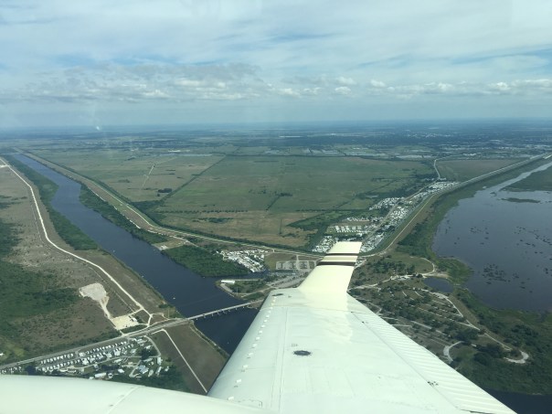
The red line shows the historic flow (in both directions depending on water levels) of the Loxahatchee Slough. Courtesy of Todd Thurlow, “Time Capsule Flights.”
Today we continue our journey of the Loxahatchee Slough, once part of southwest headwaters of today’s “Wild and Scenic,” but also water-anemic, You will see that the Loxahatchee River is located in both Martin and Palm Beach counties. My brother, Todd Thurlow’s “Time Capsule Flight” guide-posts are below to give reference during your awesome flight of this area.
Again, as in some of Todd’s other videos, you will see that humankind has developed lands “right in the middle of a river.” Certainly we would have done things differently today!
For instance, the red line in the video and photo above shows the “Southern Path From the Everglades to the Loxahatchee Slough” using 1949-1950 USGS Topo maps. Today, this once “water wonderland” is completely developed, and channelized, shutting off the once intermittent, bi-directional flow, depending on rain levels and locations… to the Loxahatchee River.
It is kind of sad that most of us are completely unaware that this giant slough was once a flourishing “fork” of the Loxahatchee River. It took me awhile to figure it out. They should teach this stuff in school. Please watch Todd’s video below. You will be in awe!
In this video you will see:
0:00 1958 USGS 1:250K Topo Quad of Palm Beach and neighboring counties
0:05 I added the red line to the map showing the path of low lands between Loxahatchee Slough and the Everglades
0:08 Eight 1949 and 1950 1:24K USGS Topo maps
0:25 Fade away to a current aerial showing the red line and flying…
— north, from the intersection of State Road 7 (US441) and Old Hammock Way (just north of The Mall at Wellington Green)
— 0:30 across the West Palm Beach Canal
— 0:33 to the south end of Loxahatchee Slough (Behind Renaissance Charter School / Okeechobee Rd & Benoist Farms Rd)
0:46 Fly up the C-18 Canal, which now splits and drains to Loxahatchee Slough (C-18/Corbett Basin)
0:59 Turnpike and I-95 interchanges at Indiantown Rd. (SR706)
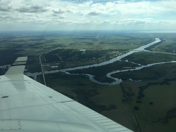
If one looks up the Loxahatchee River today there is hardly a mention of the once great southwest arm of the river, it is just a long skinny canal, ~the photo not even showing the large partially remaining Loxahatchee Slough now amputated from the river by development. https://loxahatcheeriver.org/river/about-river/
Water Catchment Area is how the Loxahatchee Slough show up on maps today. JTL
Yesterday, due to presidential Temporary Flight Restrictions, Ed and I decided to fly to the interior of the state and photograph the Kissimmee River. It was a beautiful day, but very bumpy up there.
Looking down at take off, the St Lucie River/Indian River Lagoon appeared dark-colored as the ACOE has been discharging to the river through C-44 from Lake Okeechobee since February 24, 2019 in an attempt to get the lake lower for hurricane season. It has also rained recently so there is canal (C-23; C-24 & C-25) and other runoff mixed in with the Lake O water. As we know, the “throat of our river was cut by these canals…” (https://www.saj.usace.army.mil/Media/News-Releases/Article/1791397/corps-adjusts-lake-o-releases-to-caloosahatchee-over-next-two-weeks/)
Within minutes, Ed and I had passed the Savannas, City of Port St Lucie, and were flying over sprawling agricultural lands, and then the northern diked region of Lake Okeechobee ~where the Kissimmee River meets the lake.
Today we will share photos of the approximate twenty-two miles of the Kissimmee River floodplain, once channelized, that is now being restored by the ACOE and SFWMD.
The map image below shows in detail the different parts of the floodplain-river, and its “de-construction.” For me, the Kissimmee is a the greatest example of Stuart News’ editor Ernie Lyons’ famous words: “What men do, they can undo,” as channelization in the late 1960s, was immediately recognized as an ecological disaster and people began lobbying Congress for change. Sometimes, I guess, we learn the hard way…but at least we learned. Thank you to all those who have been part of this restoration!
These five photos below show take-off from Witham Field in Stuart over Sewall’s Point, the St Lucie River and Indian River Lagoon. The last two photos are the North Fork of the SLR and Port St Lucie.
PART 2
The next six photos are the northern part of Lake Okeechobee. There is a lot of vegetation in this area that is sometimes submerged. These areas are important for bird life.
PART 3
Below we start at the still channelized mouth of the Kissimmee River entering Lake Okeechobee. As we approached the restored area, birds were flying down below, white against green, having returned to their historic nesting grounds: https://www.sfwmd.gov/news/nr_2018_0329_2017_sfwbr
~I created a self-made map to show where I took photos; (BETWEEN THE ARROWS). You will see pictures going form south to north.
West Palm Beach Canal 1940 Aerials and 1958 Topo, Todd Thurlow
You will see:
0:06 1940 USDA Aerial Index of Palm Beach County
0:20 Eight 1949 and 1950 1:24K USGS Topo maps
0:45 Pinner Island (now known as Ibis Isle)
1:01 1940 USDA Aerial – West Palm Beach Canal outlet to Lake Worth
1:40 Lake Clarke area where the Palm Beach Canal now crosses under I-95
– The road “s” turning over the canal is actually the Seaboard Air Line Railroad (now CSX)
– The Florida East Coast Railway is 0.6 miles to the east (the next canal crossing downstream)
1:54 Lake Clarke – on the 1950 Palm Beach USDA Topo
2:54 Morrison Field Airbase (later renamed Palm Beach International Airport).
See: http://www.pbchistoryonline.org/page/…
3:37 SFWMD Offices south (left) of the canal across from the airport
4:11 Wide fade-in of 1940 USDA Aerial Index – ponds and bogs of western Palm Beach County
4:21 The northern end of what is now the Loxahatchee National Wildlife Refuge
(aka WCA1 – Water Conservation Area 1)
4:41 1958 USGS 1:250K Topo Quad showing western Palm Beach County
4:49 Twenty Mile Bend
5:05 Eastern portions of the Everglades Agricultural Area (EAA)
5:46 Canal Point at the western end of the Palm Beach Canal
____________________________________
Palm Beach County is a fascinating place, especially, as in 1925, Martin County was born of it. We are connected, as is everything in this water-world of South Florida.
Today, I feature another incredible “Time Capsule Flight” by my brother, Todd Thurlow. I have recently been studying Palm Beach County and Todd’s flights help me understand what was, what is, and would can be. Palm Beach County is interesting as unlike Martin County, it has been developed very far west into the historic Everglades.
When I made a big deal out of this, my mother gave me a book published in 2000 entitled OUR CENTURY, a conglomeration of articles by the Palm Beach Post. A historian, my mother smiled saying, “Jacqui, Palm Beach County always planned on going west…”
The first article I came upon was about Louis Perini, the father of “Westward Expansion.” Eliot Kleinberg writes: “In the mid 1950s West Palm Beach was only a mile wide. But a single land deal set off a westward land rush now limited only by the Everglades…”
And to the Everglades it certainly went!
To learn some canals while were at it, you’ll see that Lake Okeechobee is connected to the historic West Palm Beach Canal, which is connected to the C-51 Canal, which in turn drains the C-51 Basins to the Lake Worth through Structure-155. Like the C-44 Canal, both lake water and basin water can be transported through the C-51 canal damaging the water quality in Lake Worth ~Sound familiar? Very similar to the plight of the St Lucie/Indian River Lagoon. Tremendous amounts of precious fresh water wasted to tide, destroying ecological habitat and property values along the way. We must do better!
In any case, it is an amazing thing to really see that we are living in what once was indeed a beautiful marshy swamp.
Enjoy Todd’s flight “West Palm Beach 1940 Aerials and 1958 Topo;” it’s time-travel into Florida’s past and into her future. Again here is the video.
Lake Worth, fading 1958 topo map to 1940 US Ag Dept. aerials ~outlet of C-51 to Lake Worth. Looking west to 20 Mile Bend going north then west again as West Palm Beach Canal leading to Lake Okeechobee. Todd Thurlow
USGS 1958 Quad Western Martin and St.Lucie, slide Todd Thurlow, Time -Capsule Flights
Today, I present, yet another incredible Time-Capsule Flight by my brother Todd Thurlow. (https://jacquithurlowlippisch.com/todd-thurlows-time-capsule-flights/). This flight takes us on a tour over the Everglades, the Everglades Agricultural Area, Loxahatchee Slough, Allapattah Flats, Ten Mile Creek, and the St Johns River Marsh, fading in and out, so one can see what the landscape/waterscape looked like in 1958 using USGA topographical maps compared to today’s Google Earth maps.
What is most striking for me, is how undeveloped, how undrained, much of the land was in 1958, not really that long ago… 61 years ago. For reference, my husband, Ed, is 62 years young!
More than we can image has happened to South Florida since 1958…
For instance, when Todd flies by notice how little sugarcane and other crop production was taking place in the Everglades Agricultural Area just south of Lake Okeechobee compared to today. Now there are about 525,000 acres of sugarcane, back then, there appears to have been fewer than 50,000 acres of sugarcane in acreage.
Everglades National Park had been in place since 1947, but look at the difference in Whitewater Bay, as well as Taylor and Shark River Slough; and what about Florida Bay?
The Loxahatchee Slough region, near Jupiter, in Palm Beach County? Holy moley, notice how the once magnificent slough was made smaller by development encroaching from every direction, eventually leaving “Grassy Waters” at the southern end – as the sole water supply, via rainfall for all of West Palm Beach…
When Todd travels north over Marin, St Lucie, and the southern edge of Indian River County, perhaps the biggest shock for me endures, as I grew up in this area ~(For reference, I’m 55 years old 🙂
You’ll see that on the USGA map, southern Indian River, St Lucie, and Martin counties are shown in wavy blue as a gigantic marsh, at certain times of year, FULL of clean water!!!! Crazy! Since 1958 these lands have been drained (Ten Mile Creek) that was hydrologically connected to the marsh, through canals C-23, C-24 and C-25; and the waters of the St Johns “Stick Marsh,”( the headwaters of the St Johns River), a north flowing river, are now also drained south into the St Lucie River. Agriculture fields and nearby highways cover those most of those stick marsh lands today.
And the central larger marsh? “Allattah Flats,” also known as “Allpattah Marsh,” or in old military Indian war maps, “Alpatiokee Swamp? Well, the City of Port St Lucie, with over 250,000 residents, and acres of ailing greening orange groves, and more agricultural fields fill these areas today.
Just unbelievable, isn’t it?
Talk about “taking control of one’s environment. “Kind of cool, but I’d say we have really over done it, considering that now our waters, critical for life itself, are almost entirely impaired.
It is my wish that as the residents of Florida push their governments to work for cleaner water, and restore some of these lands, that we all keep in mind the history ofwhat the lands were, working with Mother Nature, not against her.
Todd’s Time Capsule Flights are an invaluable tool in recognizing how much human determination has changed these lands, and how a modern-day determination can restore them. Please click on below and enjoy! Thank you Todd!
An Incredible Flight! 1958 USGS Quads, the Everglades, Loxahatchee Slough, Allapattah Flats, and St. Johns River Marsh, by Todd Thurlow
1958 USGS Quads of the Everglades, Loxahatchee Slough, Allapattah Flats, and St. Johns River Marsh
This time capsule flight overlays three 1958 USGS Quadrangle Maps of southeast Florida from Florida Bay to the St. Johns River Marsh in Indian River County. You will see the following places: 0:30 Whitewater Bay 0:39 Shark River 1:44 The Everglades Agricultural Area (EAA) 2:20 Loxahatchee Slough 3:15 Allapattah Flats 3:35 Tenmile Creek 4:03 St. Johns River Marsh
1.Ed and the Super Cub 2019. Our “eye in the sky” since 2013.2.Tip of South Sewall’s Point looking north to Hell’s Gate. Witham Field, Stuart, west.
We continue to document the discharges…
Yesterday, 3-17-19, my husband, Ed, flew the Super-Cub over the St Lucie River/Indian River Lagoon ~ twenty-one days after the ACOE started discharging from Lake Okeechobee on February 24, 2019.
When Ed arrived home, I asked, “So how was it?”
“Brown,” he replied.
“Like dark coffee brown, or kind of like that weird mixed greenish-brown?”
He looked at me, and smiled. “Jacqui, it was brown.”
“OK, I said, I’ll take a look at your photos.”
So here are the photos from Ed’s flight from Witham Field in Stuart, over Sewall’s Point and Hutchinson Island, then out west to S-80 to see the “Seven Gates of Hell” where you can see the one gate discharging now at an average of 250 cubic feet per second, down from an average of 500 cubic feet per second. As you can see from the SFWMD chart below, there has been other runoff locations as well, but the majority is from Lake Okeechobee.
3. Approaching the SL Inlet, algae covered remaining seagrass beds4.Sandbar formation inside of SL Inlet5.Blurry but shows boats at the Sandbar and that weird green brown color6.Sailfish Point and SL Inlet algae covered remaining seagrass beds7. Ernie Lyons Bridge, IRL with SL inlet and Hutchinson Island in distance8. S-80 along C-44 Canal or the Seven Gate of Hell, boats going through locks, “250” cubic feet per second coming though
The following phots are of Caulkins Water Farm, a former orange grove that died due to citrus greening that now holds water from the C-44 Canal. This is a wonderful thing! As local ag-man Mr. Hadad, told me once, “Jacqui we spent 100 years taking the water off the land, and we’ll spend the next 100 years putting it back on.” The later photos are of S-80 again with view of C-44 canal leading west to Lake O.(https://www.facebook.com/CaulkinsWaterFarm/)
9.10.11.12.13.14.15.16.17.18.19.20.21.22.23.24.
The following photos are when Ed headed back to Witham Field going once again over the St Lucie Inlet over the Atlantic Ocean. You can see the water looks blue north of Sailfish Point north of the inlet with nearshore reefs visible. Plume is also visible south of St Lucie Inlet. Also in photos is the winding Jupiter Narrows and St Lucie River in the area of Stuart and Rio. You can see Langford Landing with scraped orange soil and docks built into river still under construction since 2015.
Overlay of 1883 USCGS Map over Google Earth, Todd Thurlow.
Today’s post is super cool. My brother, Todd Thurlow, Time Capsule Flights, made a fly over of Lake Worth over the Haulover and Sawgrass Route to Jupiter Inlet using 1883 USCGS maps. His inspiration? Marty Baum’s recent comment on “The Gale of 1878, Ten Mile Creek.”
An excerpt from Marty’s retelling of his great-great grandfather, Hannibal D. Pierce, referred to as “Father” below, reads:
“…A few days after the storm Father reached home in a skiff borrowed from Mr. Rogers, the lone settler at the haulover. The last hurricane having raised the water in the sawgrass to an extreme height and good northeast wind blowing, Father decided to try the sawgrass route from Jupiter to the lake. He found the swamp like a great open lake, and had no difficulty in its navigation in the Creole; he landed at the haulover only a few hours after leaving Jupiter. Here he had to leave the Creole until help could be found to haul her over the three hundred yards of hill and dale to the lake. Borrowing the skiff of Mr. Rogers, he rowed it to his home a distance of twenty miles…”
What Todd’s video allows us to see is that, indeed, in the old days, after a gale, one could sail from Jupiter to Lake Worth, east and west of today’s U.S. 1, south through a sawgrass river! The sawgrass river today? High rise building, shopping malls, and gated communities….
I find this absolutely amazing, and a bit strange. 🙂
Please enjoy the video below!
Marty’s comment and the post the “Gale of 1878, Ten Mile Creek” is reposted for reference.
This time capsule flight shows the 1883 USCGS Maps from the south end of Lake Worth over the following areas:
0:44 The homestead of Hannibal Dillingham Pierce (father of barefoot mailman Charlie Pierce)
0:46 Hypoluxo Island
2:07 The old Lake Worth Inlet (note the 3D image of the Palm Beach Marriott Singer Island Beach Resort on that spot!)
3:08 The Haulover between the north end of Lake Worth and the Sawgrass Route
4:55 Jupiter Lighthouse
5:18 The old Jupiter Inlet (about 1/3 mile or 630 yards south of the current inlet)
I am a serious student of this, and the next storm that year. Hannibal D. Pierce, my GG Grandfather back at the homestead on Hypoluxo Island having served a couple years as Keeper at Orange Grove HOR. had recovered a longboat from the Providentia wreck Feb 1878. He sloop rigged it and took it on its maiden voyage to Titusville. Charles W. Pierce; On Wings of the Wind, unpublished manuscript.
Cheap enough some would say, but there were some settlers who could not afford to spend any money buying nuts to plant; they needed what money they had to buy food and clothes. These people did not plant any coconuts from the wreck of the Providencia. But Hammon and Lainheart opened their hearts to Father after he bought 200 nuts for himself, 200 for Cecil Upton, and seven hundred for Captain Armour; they gave him the Providencia’s longboat. This boat was a heavy built round bottom boat, twenty feet long and six wide. …
When Father got the Providencia’s longboat home, (Hypoluxo Island, today, under the Manalapan Club) he hauled it out at his east landing and planned to make her into a sloop. Uncle Will and Mr. [Ruben] Pease, who were good carpenters, helped with the work of putting in a centerboard and half decking her forward and along the sides. When rigged with a jib and a leg-o-mutton mainsail she made a pretty good sa
It was the first week of September that Father announced his intention of making a trip to Titusville in his new boat, the Creole, for much needed supplies. … When Father had been gone about two weeks there came a hurricane. It was not a very bad one, but it lasted five days. A few days after the storm, the seas were calm and we looked for Father to return. But he did not show up and the weather became stormy again and there was no news from up river in all that time. No one came to the lake so there was no news of storm damage from up Indian River, nor any news from Father, and the family on Hypoluxo Island was worried and anxious.
We kept on worrying and wondering as week after week went by and no word from Father or the Creole. I spent a good part of each day, when not hunting or fishing, in the top of an old rubber tree that stood on the west shore of the island south of the landing, with the old long spyglass resting over a limb I scanned closely the lake to the northward. While the magnifying power of the old telescope brought distant islands and shorelines into plain view, it did not show that which I most longed to see – Father’s boat coming home.
One day as I climbed to my customary perch in the tree I was overjoyed to see a sail far up the lake. But a minute’s scrutiny with the spyglass caused my sudden joy to vanish; it was not Father’s boat, but a much smaller craft. It was a very small boat that had come from up river by way of the sawgrass route; they brought a letter from Father, who was at Jupiter waiting for a smooth sea to make the outside run to the lake. We were certainly pleased to hear that he was safe and well and so near home. But days and days went by and the wind continued to blow hard from off the ocean and then there came another hurricane, which lasted only a day and one night, but was most severe; the worst we had experienced since 1876. The wind was from the east-northeast on the first day and most of the following night, and how it did blow and rain. The rain was the most tremendous any of the settlers had ever seen before or since. The rain drove in through the sides of the house until the entire inside was afloat; boards had to be laid on the floor so Mother could attend to her work without wading. About two o’clock in the morning the wind shifted to the southeast and about an hour later began to slacken just a little. Up to this time it had been impossible for us to sleep on account of the roar of wind and rain and of the possibility the house might be blown down. When the wind shifted there was some protection afforded by a hammock to the southeast of the house, and knowing by the change of the wind that the hardest had passed, we “turned in,” as the sailors call going to bed.
In the morning a scene of desolation met our gaze when we went to the door and looked out. Coconut trees blown down or their leaves whipped to threads, leaves and limbs scattered all over, bananas all flat on the ground, and not a whole tree or plant anywhere; and the lake – it was near five feet higher than before the storm. The whole back country was flooded by the September blow and now this had caused it to rise beyond all bounds. It flowed over the low spot in the spruce ridge to the north of Bradley’s through the pine woods into Lake Worth. And up across from the inlet it flowed into the lake from the back swamp in such a volume it created a large deep creek.
A few days after the storm Father reached home in a skiff borrowed from Mr. Rogers, the lone settler at the haulover. The last hurricane having raised the water in the sawgrass to an extreme height and good northeast wind blowing, Father decided to try the sawgrass route from Jupiter to the lake. He found the swamp like a great open lake, and had no difficulty in its navigation in the Creole; he landed at the haulover only a few hours after leaving Jupiter. Here he had to leave the Creole until help could be found to haul her over the three hundred yards of hill and dale to the lake. Borrowing the skiff of Mr. Rogers, he rowed it to his home a distance of twenty miles.
It was a week or so later that the tram road was built at the haulover, and the Creole was the first freight hauled by the new road from the swamp to the lake, and when she again rode anchor near her home dock, eight weeks had elapsed since her departure for Titusville.”
I tell this story in the first person AS my Grandfather. The trip took nearly months to complete. As an aside, Emily Lagow (she MET Jim Bell who she later married on this trip) was but a day behind my Grandfather in Captain Abbotts trade boaton its first trip down the lagoon boat and rode the hurricane out anchored near Gilbert’s Bar HOR. Gramps was at Jupiter Light. Em Lagow even stopped and visited the Faber Brothers at Rockledge where my Gramps had weathered the 5 day storm while suffering the flu. Here is Em Lagow Bell’s account; From My Pioneer Days the above booklet Sandy shared with Jacqui;
“We went on to the House of Refuge at Peck’s Lake, on the way to Jupiter. “We got the sails all down, for the clouds were black, and about four in the afternoon it began to rain and blow so that the spray came over on the boat, but we were in a good harbor and it was fierce all night, and lasted 24 hours. We were all right. That was my first experience of gales in Florida. I was so scared I couldn’t lie down or sleep till it was over.
We started for Jupiter and arrived at noon, so glad to get ashore to walk around. ”
My Gramps had left that morning up Lake Worth Creek to Mr. Rogers mentioned above. Jacquie, I transcribed this document years ago and not only have the story, but I indexed it also. Yours for the asking. Cheers!
Temporary Flight Restrictions were in place this weekend as President Trump and the First Lady were visiting their home, Mar-a-Lago, in Palm Beach. The restrictions go right up to the edge of Stuart, thus it was not possible to fly into the Crossroads or St Lucie Inlet to continue documenting the discharges that began on February 23, 2019.
Instead, today, I am posting a link to an article by Tyler Treadway of TCPalm entitled:
If Army Corps stops Lake Okeechobee discharges soon, St. Lucie River Suffers Little Harm. It states:
“Two weeks of Lake Okeechobee discharges haven’t caused much damage to the St. Lucie River estuary, but an environmental expert says extending the releases much longer could be devastating.
The Army Corps of Engineers, which started discharging lake water to the river estuary Feb. 25 at an average daily rate of about 323 million gallons, plans for the releases to continue at least until March 16.
They’d better not last much longer, said Mark Perry, executive director of the Florida Oceanographic Society in Stuart.”
From what I understand the releases are scheduled for 21 days which would put them through around March 15, 2019.
Ed did fly to Zephyr Hills near Tampa, so I asked him to take photos of that trip. Below you can see Moore Haven, S-308 Port Mayaca, Lake Okeechobee, and other aerials of interest. Ed said he saw no cyanobacteria or blue-green algae in Lake Okeechobee.
S-308 at Port Mayaca, going to C-44 and SLR.Near Moore Haven where canal goes to Calooshatchee, near S-79.Somewhere on the way to Tampa region.Over Lake O.Looks like part or Restored Kissimmee River above Lake O, with canal.Flood plainLake O againC-44 canal, FPL pond, heading to Stuart. S-308 just being passed at Port Mayaca, Lake O.
Near Tampa, Zephyr Hills area – area one sees what looks like phosphate ponds, mines this is a big issue for water quality for rivers like the Peace and others in Central Florida.
Ed and I will try for an update of the discharges next week!
Excerpt of a survey map, 1919, courtesy Mike Middlebrook, Natural Resources Manager, St Lucie County.
The following are two rare accounts of pioneer life documenting the extreme rain event of 1878. The first is from A. Hendry Sr., and the other by Emily Lagow Bell. These related families lived along the banks of Ten Mile Creek at the time of this flood. Their stories give us insight into a world we cannot even image today.
Historian Sandra Henderson Thurlow, (http://www.sandrathurlow.com)
had transcribed these accounts from old newspaper articles and a book. Apparently, the News Tribune had the wonderful idea of a “contest for old timers” and people wrote in.
Sandra, my mother, recently came across her transcriptions again, after I visited the Richard E. Becker Preserve in St Lucie County and started asking questions.
Today I put these valuable recollections out for all to read. I think you will find them as interesting as I do.
We must not forget that are living in a Land Remembered!
Ten Mile Creek and Five Mile Creek are visible on this 1884 map – look just south of Ft Pierce. These “creeks” are the northern headwaters of the St Lucie River. They have been drained, tamed, and destroyed by the C&SFP canal system C-23, C-24 and C-25.
TWO RARE ACCOUNTS
I.
Transcribed by Sandra H. Thurlow
News Tribune
Nov. 26, 1978
“Miley’s Memos”
by Charles S. Miley
A. Hendry was one of the first settlers of this area, and one of the pioneer cattlemen.
Born near Bartow, he came here with his parents at the age of 14, when there were but a handful of settlers in the area. As was the case with most other early settlers, he engaged in the cattle business during his late youth hood and all his adult life, reportedly being among the largest cattle owners in the state. He and K. B. Raulerson established the East Coast Cattle Co., which later became the Raulerson Cattle Co., forerunner of some of the present-day cattle operations.
He died at the age of 87 and he and his wife are buried in the Fort Pierce cemetery.
A son, A. A. “Buck” Henry, Jr., presently lives at 3576 N. E. Skyline drive, Jensen Beach, but spent most of his life in Fort Pierce and is well known among many of our residents.
When the News Tribuneconducted an old timer’s letter writing contest in February of 1934, the senior Hendry wrote a letter relating some of his experiences as an early settler of the area.
Here is the letter.
Fort Pierce, Florida
February 20, 1934
Within less than eight miles of White City, where I hope this will be read as a prize-winning letter, has been my home for 62 years, one month and one week.
For early in January, 1872, my father and mother and eight children left Polk County with two wagons drawn by oxen. After two weeks slow traveling over the old government trail, Ft. Meade, Ft. Kissimmee, Ft. Drum, we arrived at Fort Pierce. We drove our cattle with us and camped where night caught us.
We settled on the south side of Ten Mile creek, where later was located the Lisk and Roden Gove, later owned by B. J. Selvitz.
Of my father’s eight children, seven are still living, three still in this neighborhood, Mrs. Frank Bell, John Hendry and myself.
At the time of our arrival Henry Parker lived in Fr. Drum and Elias Jernigan lived on what is now the Standard Growers grove at Ten Mile; on the south lived Lang on St. Lucie River bluff just south of White City, clearing what has since become the Edwards grove, now owned by Mr. Martin East was the trading post. of the old fort, run by Alex Bell (who had arrived the year before) and a Mr. Smith; on the north lived Jim Russel and the Paine family at Ft. Capron. Beyond these points, outside of possible wandering trappers and hunters, there were no settlers short of Ft. Bassenger, Ft. Jupiter, where lived Captain Armour and Mr. Carlin, and Sebastian, where Col. Gibson lived.
An occasional band of Indians stopped on their way to the “fort,” where they would swap deer skins and other hides for beads, cloth, ammunition, salt, etc.
Their main cooking was what they called “sofkee,” ─ a tick soupy mixture of meat, grits, meal, potatoes, beans, or anything they might happen to have, boiled in a copper kettle swung over a slow fire. When done, they would squat around the kettle and pass around the one big spoon for individual use or would gorge out a handful and pour or suck off their fingers. First the bucks would eat till they had enough, then the squaws and pickaninnies. They liked white man’s cooking and lost no opportunity to enjoy it. They were especially fond of milk, never having any milk cows of their own. They would always divide with us whenever they had anything to eat that we did not have.
These Indians were of Old Parker’s band. They were known also as the Cow Creek Indians.
There were about a hundred of them in all. Their headquarters were in the Indiantown section.
September 7, 8, 9, and 10thin the year of 1878, there was a gale with a heavy rain. The Ten Mile creek’s banks overflowed. When the water came up in the floor of our cabin I built a rough boat in the hall and poled my people across the creek to Asbury Seller’s place. Finding them gone, I became somewhat alarmed. Then I poled on east to John Sellers and spent the night there with their family. Next day we all took refuge on the “mound” ─ still standing, what is left of it, just south of the road about a mile west of Five Mile.
There were 32 of us men, women and children and we spent there two days and one night. We had no shelter and were drenched to the skin. We managed to build a fire which we kept going with driftwood. We brought provisions along but were gladdened by the addition of a deer which swam up and which we killed with a pole. On returning home we found the water had been up two of three feet in the house, according to the marks on the walls.
We lived a rough, hard but healthy life. Plenty of clean food and plenty of outdoor exercise getting it. We had no Sunday schools or churches for years. We soon had a few months school for the younger children and we older ones picked up reading and writing as best we could. Mail, at best, came once a week by sail boat, newspapers were scarce, and magazines scarcer.
I have seen and used ox carts, mule teams, horse and buggy, railroad cars and automobiles on land, and the rowboat, sailboat and steamboat on the water; and overhead the airplane. What next?
Yours truly,
A. HENDRY, SR.
II.
About the Williams Mound:
Emily Lagow Bell, My Pioneer Days in Florida, 1928
I have a copy of this rare book
Sandra Thurlow
April 26, 2003
page 21:
…Alexander Bell and family, also Mr. Archibald Hendry’s family, Mr. Sellers and family were living at Ten Mile Creek. This was the 1878 storm.
The gale lasted 24 hours and the creek began to rise and James Bell and brother, Frank, and others found they had to get something to save the women and children, so took the floor out of the house , made a raft, and the water was in the house then! Well, he took his mother and children first to an Indian mound, which I think is near Ten Mile creek yet. He had to make several trips before he got them all and forgot his horse, and it drowned in the yard.
There were cattle, hogs, deer, snakes, and coons, possums, turkeys all coming to the mound. Hundreds of stock and animals drowned. They built fires on the mound and the second day the water was receding and all came into Fort Pierce.
page 28:
…Then there were several men hunting the frostproof part of the state for new groves, and my father-in-law had died, and the family decided to sell the Ten Mile place and a Mr. Sid Williams came about 1894 or 1895, and he bought the place at a very low figure, something like five or six hundred dollars, and he built up something like one hundred acres of groves which sold for a fabulous price. Now it is owned by the Standard Growers.
If you look in the upper right corner of this 1884 map of Florida, you will see the Ten Mile Creek area near Ft Pierce, in today’s St Lucie County. This area was one of the most beloved places as written about by Stuart News editor (1945-1975) and St Lucie River advocate, Ernie Lyons.
Much to Lyons and others dismay, over time, this area became channelized by canals C-23, C-24 and C-25 as part of the Central and South Florida Project. Although these canals are not connected to Lake Okeechobee, they are very destructive to the health of the St Lucie River. These lands once marsh like and sacred to mound building Indians, were drained for citrus and development in the early 1950 and 60s. Pollution contamination became a serious issue in these “protected headwaters.” (https://jacquithurlowlippisch.com/tag/ten-mile-creek/)
Today, a reservoir and storm water treatment area are functional, finally, to begin to mitigate the situation. St Lucie County itself is doing great things having to do with restoration. The area is so special and remains full of remnants of Old Florida, “a land to be remembered.”
I plan on doing a series of posts on this subject, and today I begin with presentations by Dr Gary Goforth. Who better to begin our journey of learning more about 10 Mile Creek!
__________________________________________
Jacqui –
Last month I was invited to give a presentation on the North Fork of the St. Lucie River by the Conservation Alliance of St. Lucie County and the Oxbow Eco-Center.
North Fork of the St Lucie River is fed by Five and Ten Miles Creeks in St Lucie County. Once the glorious headwaters, they are today hardly recognizable. JTL
An excerpt by Ernie Lyons
THERE was never anything more beautiful than a natural South Florida River, like the North and South Fork of the St. Lucie and the winding cypress-bordered Loxahatchee.
THEIR banks of cabbage palms and live oaks draped with Spanish moss and studded with crimson-flowered air plants and delicate wild orchids were scenes of tropical wonder, reflected back from the mirror-like onyx surface of the water.
EVERY BEND of their serpentine lengths brought new delights. Here would be clumps of fragile white spider lilies in bloom, there an alligator easing down, an otter swimming or an anhinga, the snake bird or water turkey, drying its spread wings on a dead snag. If its wings weren’t dry enough to fly, the water turkey would plunge into the river and swim off under water.
THERE were pileated woodpeckers pounding away on dead pines, egrets and herons, occasionally flocks of wild turkeys thundering over. But the most wonderful thing was the water itself, pure, sweet, cool fresh water. For miles down from the headwaters you could lean over and drink your fill. Water the way God made it. No Chlorine. No chemical additives. No salt.
IN THIS marvelous fresh water there was an incredible population of black bass and blue gills and all other finny tribes of the freshwater. There were catfish, gars and mudfish, and that strange fish with green bones called the Chinese pike or “sleeper, ” also snook and tarpon which had come up from the brackish into the fresh water zone.
THERE had always been fresh water in the upper zones, furnishing some of the most marvelous sport fishing conceivable. The fresh water was constantly replenished by a steady flow from saw grass swamps and cypress lakes, as well as by thousands of little trickles in the banks from a high ground water level. True, the tides pushed the fresh water back and diluted it with a brackish mixture in the lower zones, but there was always enough more fresh water coming in so that the headwaters held their own.
DRAINAGE canals, mostly for agricultural purposes, cut the throats of the upper rivers. During the periods of heavy rainfall, muddy waters gushed down and turned the formerly clear streams into a turbid, silted mess. During dry spells, gated dams held back water for irrigation. The ground water table was lowered. Salt marched upstream, turning the formerly fresh waters brackish and eventually so salty fresh water fish could not procreate.
THE MARVELOUS fresh water fishing expired, majestic cypresses along the banks of the Loxahatchee began to die. The banks are still beautiful, but just a shadow of what they had been.
WHAT brings all of this to mind is that, at long last, South Florida Water Management District plans to begin an “experimental release” of around 1,000 cubic feet per second of fresh Lake Okeechobee water from St. Lucie Canal into the St. Lucie River. All South Florida rivers require a reasonable amount of fresh water. Too much is disastrous.
NOW, if they can devise ways to reintroduce steady flows into the North and South Forks and the Loxahatchee, some paradises might be restored.
Some months ago, the original “River Warrior” Piper Cub was replaced with a Super Cub. Because the Super Cub is so much more powerful, more like a helicopter, it is much windier in the back of the plane, where I sit. I almost dropped my beloved iPhone, many times, before I gave up….
I have had to replace my lightweight and versatile iPhone with a “real” camera as the weight of the camera is stabilizing. Today, I share some of my other aerials of the St Lucie/IRL Region from 3-2-19, taken with this heavier camera. I thank my husband Ed for “giving me wings.” Over the coming months, as I adapt, we shall begin to document all of Florida’s east coast. First, here’s home!
Photo Ed Lippisch, Jacqui with new camera over barren seagrass beds, Sailfish Flats. Looking towards North Hutchinson Island, nearshore reefs, JTL Sailfish Point at St Lucie Inlet, JTL Atlantic Ocean looking east, JTL IRL and Jensen Beach Bridge, looking east, JTL Hutchinson Island, Sailfish Point, IRL, Sewall’s Point in distance. Sailfish Flats lie between. JTL Barren Sailfish Flats, JTL Indian River Plantation and Cove, Marriott, JTL IRL, St Lucie Power Plant in background. JTL IRL- Birds on a sandbar? No, a regatta! JTL The Savannas, near Jensen, behind Indian River Drive, JTL Savannah Road and US 1 leading to St Lucie River’s Roosevelt Bridge, Stuart, JTL Expanding Town of Ocean Breeze Park, IRL, JTL Rio/Jensen, Warner Creek, peninsula of Sewall’s Point, Stuart proper and airport, JTL Destructive C-23 canal separating Martin and St Lucie Counties across from North River Shores, SLR, JTL Dixie Highway and train track, JTL US 1 Roosevelt Bridge, discharges from LO coming through – see sediment…
Circling back over the IRL and US Sailing Center’s regatta, a beautiful sight!
The remaining photos are coming in for landing circling over the St Lucie at Roosevelt Bridge and developed lands…
Looking towards Palm City over SLR
Please note all comments become part of the Public Record.
Last week, on Friday, the ACOE announced in order to lower Lake O for wet season, it would begin discharging for the next 21 days from Lake Okeechobee into the St Lucie River/Indian River Lagoon with an average of 500 cubic feet per second through S-80 at St Lucie Locks and Dam.
My husband, Ed, and I took aerial photos at the beginning of these discharges on 2-24-19; we continue our documentation today, and in the future. The first set below was taken on Friday, March 1st around 3pm. The second on Saturday, March 2, around 12:30 pm. In both cases, it was an incoming tide ~with more sunshine on Saturday. Obviously, one can see negative changes in water-color and clarity after one week of discharges.
SFWMD basin map for SLR showing S-308 and S-80 along with other structures.
Set #1, 3-1-19, 3:10pm Ed Lippisch all photos
In this photo one can see the airstrip at Witham Field with flight going over Crossroads of St Lucie River and Indian River Lagoon as confluence meets at Sewall’s Point flowing out to St Lucie Inlet at Hutchison Island. The bare sand was formerly rich seagrass beds that have been devastated by the discharges. All photos are taken in this area of the St Lucie Inlet.
This past week, I was invited by the City of Port St Luice for their “St Lucie County and City of Port St Lucie IRL South Comprehensive Everglades Restoration Plan and McCarty Ranch Tour.”
As McCarty Ranch was presented by video, I couldn’t help but grin as I watched ACOE Lt Col Jennifer Reynolds. It appeared we were watching a project featured by the Army Corp of Engineers itself.
“Maybe the Army Corp has met its competition, ” I thought.
City of Port St Lucie, Mayor Greg Oravec praised his city’s Water Quality Warriors, “Our City is doing projects on scale with the Central Everglades Restoration Plan, CERP.”
I find this inspirational and amazing.
The tour showcased the good that we can do ourselves. With the leadership of charismatic visionaries like Mayor Oravec, local governments can get started today!
Lt Col. Reynold’s response? “You don’t have to do everything. You just have to do what you can do.” 🙂
Kudos, Port St Lucie and St Lucie County! You are setting an example for all!
Here a portion of Ten Mile Creek is presently blocked by fill. It will be opened and restored. Many unique fish species use these upper areas of the North Fork and Dr Grant Gilmore studies this area closely.Ten Mile Creek stopped up by fillBlue shirt, Mike Middlebrook Natural Resources Manager explains the reconnection.

 https://loxahatcheeriver.org/river/about-river/