Monthly Archives: July 2018

#ToddThurlow #CIcyanoTrueColor; Lake O Tool-Kit

We all know, knowledge is power.

My brother, Todd, has programmed a way to present a running comparative of satellite imagery in an easy way for all to understand. These images are a revolutionary tool for the St Lucie River movement and for the state of Florida. They help us to understand, and put us in a better position to ask for change as we are up to date and we know how things work.  And although experimental, the concept is on track. Make this link a permanent part of your Lake Okeechobee tool kit. Read here:

http://www.thurlowpa.com/LakeOImagery/NCCOS%20HAB%20Images/index.html

My brother Todd and I in 2016.

#ToddThurlow #CIcyanoTrue Color #ThurlowClcyanoTrueColor

“Farewell Dear Friend,” River Warrior Plane, SLR/IRL

I’m the kind of person who gets attached. I’m loyal to people and things that are good to me. One of those is the Legend Cub, the little yellow airplane that started flying in Stuart in 2013.

As she began to fly over the St Lucie River/Indian River Lagoon helping spot destruction from Lake Okeechobee discharges, she came to be known by those who saw her from the ground as the “River Warrior.” Over time, she became known far and wide to pilots, guests, reporters, home-owners, boaters, beach-goers, and children. She flew over multiple river rallies tipping wings side-to-side “waving” inspiring thousands of people.

She inspired me too.

When I was too afraid to get up in the air with my husband, it was she who gave me wings. I trusted her to help me tell our River Story and she did. She discovered algae water pouring through S-80 and the gigantic algae blooms documented in Lake Okeechobee…

Looking back on the thousands of photos Ed and I took from her open cockpit, these photos starting with the Treasure Coast Council of Local Governments, were shared and published~during that changing “Lost Summer,” of 2013, and then 2016, and now, 2018.

The River Warrior’s distinctive yellow strutted aerials have been instrumental in gaining statewide and national attention of the government sponsored destruction of our St Lucie River. The little plane gave us our first look from above and she woke us to action, yes, she did.

~Never a stutter and always with a singing engine she flew…

Since 2013, there have been more “Lost Summers,” now complete with disappeared seagrasses, and toxic blue-green algae to boot. She has seen it all. And today, there are now a total of five Cubs in Martin and Lee Counties. Indeed, being so cute and reliable, she stared a trend.

Nonetheless, next week, she is being sold and replaced with a “better” model. For me, there is no better model. She has changed the game; she gave me confidence to fly when I had none; she shall be missed and remembered forever. So if you see her this final week please wave “goodbye” and wish her well.

Farewell and thank you River Warrior plane. May your next adventure be as touching to those around you, as you have been to me. You are, and alway will be, the soul and heart of our river movement legend.

Love,

Jacqui

Photos from 2013

One of many algae blooms on Lake O:

July 18, 2017
May 30, 2016

One of many river rallies:

NCCOS/NOAA Satellite Imagery, Making the Connection, Todd Thurlow

http://www.thurlowpa.com/LakeOImagery/NCCOS%20HAB%20Images/index.html

If you’re like me, you might wonder about the various satellite images in the news and on social media showing the cyanobacteria, also known as blue-green algae, in Lake Okeechobee. What’s the connection between the colorized and the not? How do the scientists determine the colorized image? Where do they come from?

In this post, I share a link to my brother, Todd Thurlow’s latest creation, “NCCOS HAB Images.” This exciting site juxtaposes an experimental product of the National Centers for Coastal Science, NCCOS, being used to track Harmful Algae Blooms, HABs, in Lake Okeechobee, to NOAA True Color, or enhanced traditional satellite images.
The NCCOS images are referenced by The South Florida Water Management District, however, experimental. Experimental or not they are cool, tell us a lot, and they are interesting!

Before relying on a CICyano (Chlorophyll Cyanobacteria Index) image, scientists must first look at the “true color” version to determine if clouds or sunlight reflections have corrupted the data. Todd has made it easy for us to compare the NCCOS “Chlorophyll Cyanobacteria Index” pictures to the corresponding “True Color” picture. He processed hundreds of images, putting them side by side. Generally, if there are clouds on the right image, then the left image may not be so reliable. But if there are no clouds on the right, then the left image is a good indicator of algae.

This site is an awesome visual tool we can now reference as we continue to learn about HABs in Lake Okeechobee. Technology is a powerful path for connecting to a “better water future.”

SEE LINK BELOW FOR SITE: http://www.thurlowpa.com/LakeOImagery/NCCOS%20HAB%20Images/index.html


http://www.thurlowpa.com/LakeOImagery/NCCOS%20HAB%20Images/index.html

LINKS:

National Centers for Coastal Science: http://coastalscience.noaa.gov

NOAA, Harmful Algae Blooms: https://oceanservice.noaa.gov/hazards/hab/

Blue-Green Algae Present, Lake O Bloom Subsiding, SLR/IRL


Documenting the discharges, is critical whether by air, on the ground, or from outer space.

The two videos above were taken by me over S-308 at Port Mayaca,  the opening from  Lake Okeechobee to the St Lucie River, and over S-80 at St Lucie Locks and Dam on Friday, July 20th, 2018. The satellite images below, my brother Todd Thurlow provided, were taken the same day.

It is clear that the blue-green algae/cyanobacteria, covering, at its height, 90% of Lake Okeechobee, has run its course and bloomed. Now, as the “flower falls,” we see what’s  left.

As seen in the aerials, and what the satellite images cannot portray, is that the algae is still there just lessened. Flying out over the lake a light green algae film remains over the water, a pastel shadow of its once flourescent self.

7-20-18, light colored algae, Lake O off eastern shoreline, JTL

The seven aerials at the end of this blog post were taken by my husband, Ed,  this afternoon, July 22, 2018 around 4pm. The tremendous green shock is gone, but squiggly lines of nutrient bubbles remain, and blue-green algae visibly lines the eastern shoreline to be sucked into the gates…

Will another gigantic bloom arise? Another flower to replace the dropped blooms of yesterday? Only time shall tell…

One thing is certain. Nutrient pollution (Phosphorus and Nitrogen) is destroying Florida’s waters, and unless non-point pollution, especially fertilizer runoff from the agriculture community, is addressed, faster than Florida’s Basin Management Action Plan requires- pushed out 30  or more years, we are will be living with reoccurring blooms indefinitely.

A great book on this subject is Clean Coastal Waters, Understanding and Reducing the Effects of Nutrient Pollution, National Reaseach Council 2000, https://www.nap.edu/catalog/9812/clean-coastal-waters-understanding-and-reducing-the-effects-of-nutrient

Read below how Florida is trying to fix its impaired waters; nice try but no urgency. As we all know, there is no time to wait.

Florida Dept. of Environmental Protections Basin Management Action Plan: https://floridadep.gov/dear/water-quality-restoration/content/basin-management-action-plans-bmaps


Sentinel-2 L1C, SWIR on 2018-07-20.jpg 1,638×1,637 pixels, courtesy of Todd Thurlow. Visit his site here: http://www.thurlowpa.com/LakeOImagery/%5B/

Sentinel-2 L1C, True color on 2018-07-20.jpg 1,668×1,668 pixels, courtesy of Todd Thurlow. Visit Todd’s site here: http://www.thurlowpa.com/LakeOImagery/
Ed Lippisch S-308 at Port Mayaca, the opening form Lake O to C-44 Canal and SLR, 7-22-18
Ed Lippisch 7-22-18
Ed Lippisch 7-22-18
Ed Lippisch 7-22-18
Ed Lippisch 7-22-18
Ed Lippisch 7-22-18
Ed Lippisch 7-22-18

Timely quote for thought by the late Mr Nathaniel Reed 1933-2018

“…The fact that the Department of Environmental Protection and the Everglades Foundation have at last identified every polluter in the vast Okeechobee headwaters is an astonishing feat. The sheer number of polluters is mind-boggling.

The failure to enforce the possibly unenforceable standard (best management practices) shines through the research as testament to the carelessness of our state governmental agencies about enforcing strict water quality standards within the watershed.

There is not a lake, river nor estuary in Florida that is not adversely impacted by agricultural pollution.

As one of the authors of the 1973 Clean Water Act, I attempted late in the process to include agricultural pollution in the bill, but the major congressional supporters of the pending bill felt that by adding controls on agricultural pollution the bill would fail.

Now, 54 years later, fertilizer and dairy wastes are the main contributors to the pollution of the waters of our nation. Algal blooms are all too common even on the Great Lakes.”

Excerpt, Letter to the Editor, Stuart News, 2017

Lake Okeechobee Satellite Images 1982-2018, Todd Thurlow, SLR/IRL


In my last post, I shared my brother Todd Thurlow’s “Lake Okeechobee Satellite Images 1972-2013.” Today, I am sharing his Lake Okeechobee Satellite Images 1982-2018.

Hmmm?

In 1972, I was 8 years old…

In 1982, I was 18 years old…

A lot changes in ten years, and an extra-lot changes in the 100 years we have not taken good care of our state’s largest lake; this is now affecting millions of people and the remaining wildlife we have left.

Todd told me he did not “create by hand,” as I alluded to in my last post, but rather he used a USGS website tool to do it, and then converted, and loaded to YouTube, embed, etc.

In the last video the emphasis was on an a visible algae bloom in 1979, in this “video” the dates of algae blooms are not marked, but you can see clearly blooms towards the end as we reach 2018.

Unless something drastic occurs structurally, socially, and politically, I am sorry to say that we are doomed to have more and more algae blooms in the future.

#VoteWater #MakeAllPoliticiansTalkWaterAlltheTime

SEE LINK BELOW FOR VIDEO:

http://www.thurlowpa.com/LakeOImagery/Landsat4-8_1982-2018.html

Sentinel-2 L1C, True color on 2018-07-15.jpg 1,673×1,674 pixels, http://www.thurlowpa.com/LakeOImagery/

Also see Todd website for updated satellite images he makes easy to access for all to see:

http://www.thurlowpa.com/LakeOImagery/

Previous blog 1972-2013: https://jacquithurlowlippisch.com/2018/07/17/lake-okeechobee-satellite-images-1971-2013-todd-thurlow-slr-irl/

~“The consequences of ignoring ecological planning and environmental protection could be economically devastating in a way not commonly foreseen.” Environments of South Florida Present and Past, by Patrick J. Gleason 1974.

Lake Okeechobee Satellite Images 1972-2013, Todd Thurlow, SLR/IRL

My brother Todd looked through near 1000 historic satellite images to create this video of Lake Okeechobee images from 1972-2013. Wait until 2014-2018 are added! That will say a lot. But wait, it’s interesting to note, that in this video, one can see a substantial algae bloom in Lake Okeechobee in 1979.

The state of Florida has known for decades how passive “environmental protection” would add-up, that Lake O is eutrophic, and sick. The lake was made to over-flow and we contain it. We should know, you can’t contain an “ocean…”

It’s time #Florida.

WATCH VIDEO, LINK BELOW:

http://www.thurlowpa.com/LakeOImagery/Landsat1-4_1972-2013.html

Todd Thurlow:http://www.thurlowpa.com

~“The consequences of ignoring ecological planning and environmental protection could be economically devastating in a way not commonly foreseen.” Environments of South Florida Present and Past, by Patrick J. Gleason 1974.

The Champion Fallen Oak, Nathaniel Pryor Reed, SLR/IRL

Champion oak tree in Angel Oak Park, on Johns Island, South Carolina, National Registry of Champion Oaks page, 2015, https://www.americanforests.org/explore-forests/americas-biggest-trees/champion-trees-national-register/ (Image: B.B. Easton)
Christine Stapleton, Palm Beach Post 2014 https://www.mypalmbeachpost.com/news/state–regional-govt–politics/tales-nature-and-power-award-enough-for-legendary-enviro-nat-reed/IGeJCG9mimBDuetearCDvN/
My parent’s fallen oak tree, 2016.

Nathaniel Pryor Reed 1933-2018

Obituary, Washington Post: https://www.washingtonpost.com/local/obituaries/nathaniel-reed-leader-in-efforts-to-protect-endangered-wildlife-and-wetlands-dies-at-84/2018/07/13/ae25a46a-86a7-11e8-8f6c-46cb43e3f306_story.html?utm_term=.f87d9c61166c

Moon through the giant oak tree at my parents house, 11-6-14. (Photo Jacqui Thurlow-Lippisch)

The death of elderly Mr Nathaniel Reed, was not completely unexpected. He was like an ancient champion oak, old and beautifully weathered. But the news of his death was shocking, bringing  tears and heartbreak to the many touched by his long branches, and the seeds he spread along the way.

I can never “not remember” Mr Reed. He was always, since my earliest childhood, a figment of my greater imagination and consciousness, an example of what it meant to have a meaningful life and purpose,  to walk and make change in the tainted world of politics, to choose the greater-good over greed, to inspire.

During my Sewall’s Point mayorship in 2011,  I first became active in the environmental community for which Martin County is known. Mr Reed planted the seeds, writing me a note here and there, on his quality stationary; in 2016, he gave the maximum amount to my campaign when I ran for county commissioner, District 1, and in his final years, Mr Reed wrote a Letter to the Editor of the Stuart News of which he sent me a copy.

At that time my student proposed Constitution Revision Commission proposal “A Right to a Clean Environment” was getting clobbered by Affiliated Industries, the Florida Chamber, The Florida Agriculture Coalition, and other powers who had assembled a legal team, including a former Florida Chief Justice to squash this threatening idea.

I was so worn down, and had been working so hard. Mr Reed’s letter and support reinvigorated me and the students. And although the proposal did not make the vote, it made smarter people than me on the CRC and throughout the state think, about how our paradise of Florida has become so polluted, and what we can do for change.

Let’s once again read Mr Reed’s words, at the trunk of the fallen champion oak remembering that we are his acorns, or even his resurrection fern…

Thank you Mr Reed. I am forever grateful. We will work towards your legacy.

Letter: Proposed amendment a brave effort to ensure a clean environment

Dec. 8, 2017

Thank you for the Dec. 1 editorial supporting the right to a clean environment!

The “usual suspects” are opposing the constitutional amendment proposed by Jacqui Thurlow-Lippisch, which would receive strong support from the vast majority of Florida voters, just as they quietly opposed Amendment 1.

The fact that the Department of Environmental Protection and the Everglades Foundation have at last identified every polluter in the vast Okeechobee headwaters is an astonishing feat. The sheer number of polluters is mind-boggling.

The failure to enforce the possibly unenforceable standard (best management practices) shines through the research as testament to the carelessness of our state governmental agencies about enforcing strict water quality standards within the watershed.

There is not a lake, river nor estuary in Florida that is not adversely impacted by agricultural pollution.

As one of the authors of the 1973 Clean Water Act, I attempted late in the process to include agricultural pollution in the bill, but the major congressional supporters of the pending bill felt that by adding controls on agricultural pollution the bill would fail.

Now, 54 years later, fertilizer and dairy wastes are the main contributors to the pollution of the waters of our nation. Algal blooms are all too common even on the Great Lakes.

The “usual suspects” may defeat Thurlow-Lippisch’s brave effort, but you are right: The issues won’t go away!

Lefty Durando’s column clearly states the issues involved in the decades-long struggle to protect the Arctic National Wild Life Refuge. Having been there several times as assistant secretary, I have joined a group of well-known environmentalists, Republicans and Democrats urging defeat of the proposal to open the critical habitat of the coast zone to exploratory drilling. I suspect it is a lost cause, but one worth the fight to preserve the “Serengeti of the North”!

Nathaniel Reed, Hobe Sound

Links:

The Right to a Clean Environment Should Be Written Into Florida’s Constitution, JTL, Stuart News: https://www.tcpalm.com/story/opinion/contributors/2017/10/26/right-clean-environment-should-written-into-florida-constitution-guest-column/802410001/

News, Bruce Ritchie, Politico: Affiliated Industries Prepares to Fight a Right to a Clean Environment: https://www.politico.com/states/florida/story/2017/11/22/industry-to-fight-proposed-constitutional-amendment-for-clean-healthful-environment-122148

Resurrection fern

Is it Time to Address South Florida’s Greatest Taboo? “Shared Adversity,” SLR/IRL

LAKE OKEECHOBEE REGULATION SCHEDULE (LORS) http://www.saj.usace.army.mil/Portals/44/docs/h2omgmt/LORSdocs/2008_LORS_WCP_mar2008.pdf

The second she said it, I was at full attention. This past Tuesday, Sanibel-Captiva Conservation Foundation Director, Ms. Rae Ann Wessel, spoke on the Army Corps of Engineers Periodic Scientists Call. In seven years of listening, in seven years of agency and public comment, I had never heard, seriously, and scientifically, someone address South Florida’s greatest taboo.

Ms Wessel said something like this:

Part of the LORS (Lake Okeechobee Release Schedule 2008)  addresses “shared adversity.” Lake Okeechobee is approximately 470,000 acres. Would it be possible to put the water the Corps plans  to release from the lake over approximately 484,000 acres of  crop lands just south of the lake, rather than into estuaries? The Caloosahatchee algae situation is already at its absolute worst…

You could hear a pin drop…

Wessel was recommending options to the Army Corps and stakeholders regarding the ACOE restarting discharges to the estuaries. Since the previous week’s call, due to NOAA images showing 90% of the lake covered in cyanobacteria blooms, and crisis of algae in both estuaries, the Governor and other powerful politicians asked the federal agency to temporarily stop discharges considering all options before discharging, once again.

Just the previous day, before Wessel’s comment, after viewing the putrid algal mess in the Caloosahatchee, Gov. Rick Scott called for a State of Emergency encompassing seven counties.

Some history, earlier this year, the Caloosahatchee was almost begging the South Florida Water Management District and ACOE for water, but was denied. Now the Caloosahatchee is receiving so much water, with algae to boot, that they are experiencing a toxic summer similar to what the St Lucie experienced in 2016. The Caloosahatchee has had it especially tough this year.

The elephant in the room, or perhaps better described as the Tyrannosaurus rex in the room, is that with Lake Okeechobee over 14 feet, and the fact that we are now approaching the most turbulent part of hurricane season, the ACOE “has to start releasing again,” like now! And everybody knows this.

Therefore, Rae Ann was looking for options, for sharing adversity, and this was fair as the Calloosahatchee has bore most of the adversity this year. She wasn’t talking about flooding the cities in the EAA, she was inquiring about flooding the fields, by less than a foot of water that would evaporate quickly at that extension and depth, maybe stressing but not killing the crops. Sugarcane in particular, is a hardy and durable crop for intermittent periods of water.

Shared adversity… Certainly, the estuaries have have their “fair” share…

So why does the ACOEhave to dump to the estuaries? Why is it taboo to talk about flooding the fields? Because although the 2008 LORS talks about shared adversity the EAA is federally protected by an older and more important document. 

The ACOE in not a teacher picking favorites, they are the military taking orders from Congress.

The federal “law,” connected to the Central and South Florida Project (http://141.232.10.32/about/restudy_csf_devel.aspx) is complex, but perhaps best explained by sharing an excerpt from the book, River of Interests, by the Army Corp of Engineers. Page 35, discusses the 1948 Central and South Florida Project, what it did, and requires of the ACOE.(http://sccf.org/downloadable-files/5b465bf85f38152b048d1cce.pdf)

First, the Corps would build a levee from northwest Palm Beach County to the south of Dade County along the east coast, thereby preventing flooding from the Everglades to the coastal communities. Second, the Corps would modify control facilities and levees around Lake Okeechobee in order to create more water storage, and it would increase the discharge capacity from the lake in order to prevent flooding. Third, the Corps would create three water conservation areas in Palm Beach, Broward and Dade counties for water storage. Fourth, the Corps would construct canals, levees, and pumping stations to protect 700,000 acres of agriculture south of Lake Okeechobee in Palm Beach, Hendry, and Glades counties, known as the Everglades Agricultural Area (EAA). Fifth, the Corps would build canals and water control structures to handle drainage in Dade, Broward, Palm Beach, Martin, and St. Lucie counties.

This bolded section is the key, this is why Rae Ann Wessel’s question rung so loudly in the silence of the ACOE call. For the ACOE, it is “understood,” that no matter the case, even with LORS, and in spite of “shared adversity,” that 700,000 acres of agriculture fields, south of Lake Okeechobee is to be protected from flooding destruction.

But as we all know, nothing lasts forever.

Just like other laws of our great county, some do, indeed over time, become outdated for the times. Things change. Among other issues, in 1950, when the Central and South Flood Project law was structured and voted upon to protect the crops in the EAA as part of flood control  2.81 million people lived in Florida. Today, 20 million people reside here. In the old days, the discharges did not have the impact as they do today, the rivers were healthier, and the Lake, it wasn’t so polluted. But now, seventy years later, water quality, pollution, and human health issues have risen to a point of question. “In emergency situations”, is discharging cyanobacteria water from Lake Okeechobee into the now heavily populated areas along the estuaries to prevent flooding of the Everglades Agricultural Area in the state’s best interest, or is it archaic, like the T-Rex in the room?

It might be time to re-evaluate South Florida’s greatest taboo.

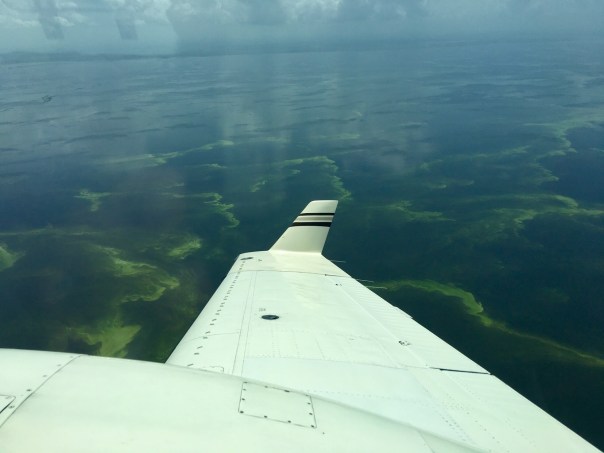
-Above aerials: Caloosahatchee algae bloom 7-6-18, photo courtesy pilot Dave Stone.

What is the Everglades Agricultural Area: https://en.wikipedia.org/wiki/Everglades_Agricultural_Area

Gov.Rick Scott State of Emergency proclamation: https://www.flgov.com/2018/07/09/gov-scott-issues-emergency-order-to-combat-algal-blooms-in-south-florida/

SCCF: (https://fortmyersbeach.news/rae-anne-wessel-of-sanibel-captiva-conservation-foundation/)

What are the ACOE Periodic Scientists Calls? Former blog post 2014: https://jacquithurlowlippisch.com/2014/03/06/the-acoes-periodic-scientists-call-and-the-indian-river-lagoon/

A Tear for Lake Okeechobee, SLR/IRL

Ed and I have just returned from vacation. Ironically leaving June 28th, the day the ACOE announced a nine-day reprieve due to algae in Lake Okeechobee; and returning July 8, the day before the ACOE may open S-308 into the St Lucie River once again.

It was a great trip and the weather was excellent.

Ed was our pilot, and we flew with stops from Stuart to Michigan. It was remarkable to sit in the airplane and see the land below me ~ever changing from swampland, to farmland, to cites, to forest, to mountains, to rivers, and peppered with hundreds of lakes….

When we finally approached the Great Lakes Region, I was looking for the algae I had read so much about, and yes, there were some lakes turned green. But not in the vast northern waters of Lake Michigan, or Lake Huron, these lakes were deep mirrors of blue.

“The water here looks like the Bahamas,” Ed noted. We both looked in wonder at their hue.

Sometimes, I awoke at night, thinking of home. Thinking about how there is nothing like it, in spite of the many wonders of our great county. In spite of the beautiful, blue, icy waters of Lake Michigan.

On the way home to Stuart, I asked Ed if we could fly inland over Lake Okeechobee just to see.  It was midday and the clouds had popped up and I knew we’d have to do my least favorite thing, fly though them. As the turbulence engulfed the airplane, I closed my eyes and prayed. And then finally, as always, we were through.

The lake opened up before us like an ocean.

I could clearly see the algae at about three thousand feet. It was visible roughly a mile off the lake’s east coast out into the lake for as far as the eye could see. Ed flew west and then circled around. The green masses of algae had been pushed into geometric designs by the wind, and they were everywhere. We flew for miles over the middle of the lake and beyond. To my surprise, the repetitive, endless, formations of cyanobacteria caused something unexpected to happen. Rather than my usual disgust, or anger for the destruction of the St Lucie, I felt myself begin to tear-up. “This poor lake,”  I thought to myself. “I know you were once so beautiful even mythical;  what have we done to you?

Just unbelievable…”

I wiped the tear from my eye, so sad for what is happening to the waters of my beloved Florida. Ed turned the plane, and we headed home…

S-308 algae was visible about a mile off the east coast of the lake and on and off, sometimes heavy, inside of the S-308 structure and in the C-44 canal to S-80 at St Lucie Locks and Dam.

S-80 was open and algae could be seen going through the gates  from the C-44 canal

Home at last. Sewall’s Point Park River Kidz FDOT recycled sign art

All photos take on July 7, 2018, 3pm. JTL/EL