Historic map, Palm Beach Farms Company Lands ca. 1910 showing “edge of Everglades.” Archives, Lawrence E. Will Museum of the Glades, Belle Glade, Fl.
Looking back gives us perspective when looking forward.
This old map showing the Palm Beach Farms Company Lands is interesting as is shows where people saw the “edge of the Everglades” when they were first developing around 1910.
Today it is hard to judge where we are and what “was” the Everglades…Some of us are literally “in it.”
Looking back, it is easy to see how after over 100 years the waters of Lake Okeechobee are becoming more and more “toxic.” Kind of like a fish tank that can never be cleaned out….
One has wonder if the developers of the Everglades ever considered what would happen to the lake by building and developing farm lands right in the way of the natural flow, and then really blocking it by eventually putting a dike around the lake? In this map, the push was to develop lands further west beyond the eastern ridge…Think all all the development today out west beyond the ridge and into the historic Everglades!
Perhaps in their wildest dreams the early developers would have never envisioned how many people live in south Florida today. Maybe they didn’t care. In any case, today we all here in South Florida are connected somehow to Lake Okeechobee, Florida’s “liquid heart,” for drinking water, recharge, recreation, property values, and our health.
Over our history the human spirit has overcome greater threats than toxic algae; I am confident we will once again.
SFWMD satellite map South Florida. Red lines denote historic Everglades.SFWMDLake O eastern shoreline, Port Mayaca, 7-21-17, JTLLake O, 7-21-17
Ariel 1925, SLR/IRL courtesy Archives of Sandra Thurlow as shared by Higgins Engineering WPB.
I have shared this 1925 aerial previously, but it is worth sharing again. What a wonderful photograph of a healthy confluence of the St Lucie River/Indian River Lagoon!
Every time I see it, I see something new.
I see the white sands of the newly dug St Lucie Canal, today’s C-44 connected to Lake Okeechobee, in the far middle distance; I see dark, prevalent natural vegetation; I see an undeveloped Sailfish Point, Rocky Point, Manatee Pocket, Sewall’s Point, and Stuart; there are a few roads, but no airport; no spoil islands along Sewall’s Point; there are no “bridges to the sea; ” I see shoaling, as the St Lucie Inlet had been opened/widened not too long before ~located just around the left hand corner of the photograph; I see beaches at Hutchinson Island with beautiful coquina sands that had not been “re-nourished;” I see lush seagrass beds, the nurseries of life, cradled against the shoreline; I see Paradise…
What would we do as far as development in this paradise, if we had it to do all over again?Or would we do just the same?
How we develop lands, of course, affects the health of surrounding waters. Today, what can we do to reinvigorate our rivers, our paradise? How can we help bring back the seagrasses especially? Well, we can do a lot.
Think of all the lawns that would be in this photo today! All the development, and how when it rains everything on our streets, parking lots, and lawns runs into our drainage systems and into our river.
Yesterday was June 1st, the beginning of rainy season. The beginning of fertilizer restrictions that were especially inspired for the entire Indian River Lagoon by the work of Sewall’s Point, the first to have a strong fertilizer ordinance, in 2010. I am proud of this and thank my fellow commissioners of that era.
Do what you can by not fertilizing your yard this rainy season, and if you haven’t considered changing out your yard to a more natural, Florida Friendly landscape, perhaps begin the process.
Every little thing we do, counts. And the more we do, the pressure we can put on the “big polluters” to do the same.
1940s Agricultural Dept. cropped aerial, showing Stuart, Florida’s ponds, wetlands and sometimes “lakes.”1950 Anniversary Edition of the Stuart News, courtesy of Sandra Henderson Thurlow.Nov. 9, 1950 Stuart News reprinting 1924 account by Edwin A. Menninger. Courtesy, historian Sandra H. Thurlow.For some stories there are no pictures, only your imagination…Today I will share a story brought to my attention by my mother in line with my recent interest in ponds.
It was September of 1924, Stuart was still part of Palm Beach County, and few people lived here. It was the “boom era” and residents were excited about building the future. But then it started raining, and raining, and raining…
By Edwin A Menninger, reprinted in the 1950 Anniversary of the Stuart News with my location references.
JUST WHAT WAS STUART LIKE 25 YEARS AGO? THE YEAR STUART ALMOST WASHED AWAY…
…We had just had four days of torrential rain. At one time it rained 36 inches in 36 hours. Stuart was flooded. The railroad tracks washed away at Rio. They washed away also just south of Salerno, and two FEC passenger trains carrying about 500 people were marooned in Stuart till the tracks could be rebuilt. The Vanderbuilts just happened to be on the train!…I published a special FLOOD EXTRA and sold 400 copies…the heavy rains made an enormous lake in th heart of Stuart. (It was before 4th Street (East Ocean) was graded and paved) and a huge lake stretched from the court house to the school.(Today’s Stuart Middle School and Ad. Buildings)
A small ditch to drain off the worst was dug from the lake’s edge (where W.V. King’s house now stands) (Across from Willie Gary’s office on Osceola today) to the St Lucie River; in an hour this became a raging torrent. Water ran so fast it dug a ditch 75 feet wide to the river, undermined houses nearby, threatened extensive damage before Curt Schroeder and his crew got things under control again. The ground was s waterlogged that drainage problems were difficult. Water stood across 4th Street (East Ocean) in deep, big ponds for more than a month in front of where John Demich now lives (today’s 5th and Cortez) and at the tennis court. The old hospital building was surrounded by water for weeks and physicians came and went in boats…
A raging torrent that dug a 75 foot ditch from East Ocean Blvd to the St Lucie River! Doctors going to the hospital in boats? Holy cow. That must have been something. How did they put back the land that washed out? Below I have tried to figure out where that area might have been…
In closing, hope you have enjoyed this week’s pond series. The message remains the same, Lake Okeechobee or a little pond on East Ocean Blvd. “Over drainage has consequences….”
________________________________________________
Notes of location referred to in the 1924 article, by Sandra Thurlow, help to figure out location:
The red dot in this Google Earth image is the historic Pelican Hotel and today the office of famous attorney Willie Gary. The King house referred to in the article was “across from here.” I believe the 75 wide inlet that formed as the canal from the pond eroded away from E Ocean to the St Lucie River would have been somewhere around this location. What do you think? JTL
Mom, where is the King’s house?
The King house was Kay Norris’s parents’ house across from the Pelican Hotel (Willie Gary’s ) The corner of our church property where Mary’s Closet is today used to flood terribly. There was once a rectory there that had to be demolished because it flooded and was ruined. Uncle Dale could tell you all about that. The King house still stands on Osceola I believe. At one time it was Dr. Eckersley’s office.
2. Where was the Dumich house?
Dumich lived on 5th Street about where Cortez intersects it.
3. Mom, remined me about the flooding when I was a kid.
Think of the courthouse. As you probably remember Memorial Park was always flooding. When it was suggested for a site for the library years before, Mary Kanner, (Kanner Highway, Highway 76, is named after her Judge husband) said “I am not going to have the library built in that sometime lake.” The pond that was dug in front of where the Log Cabin was constructed, later became the Middle School Pond. Now, it too, has been made to disappear.
Dept of Ag 1940, Martin County, showing ponds and wetlands, courtesy of UF arrives and help of Todd Thurlow.Notes of Edwin Menninger:
~Edwin A Menninger, The South Florida Developer, 1924
(Menninger purchased the weekly paper, South Florida Developer, in 1923, moving its publication headquarters to Stuart from Canal Point. In 1928 he bought the Stuart Daily News. This excerpt was reprinted in the 1950 Anniversary Edition of the Stuart News.) (This excerpt can also be found on page 453 of a History of Martin County.)
Thank you to my awesome brother Todd Thurlow who created this image after reading today’s blog post. He writes: “Hi Jacqui – If you want to see the 1924 lake, the FEMA flood maps show the low spot pretty well. Check thiis out:” ~Todd
4th Street/East Ocean Blvd 1957, Stuart, Florida, Arthur Ruhnke. Courtesy archives of historian, Sandra Henderson Thurlow.“See that white strip just below the wetland? That is the extension of Flamingo Drive that skirts the pond behind the old car wash. They just dug a retention pond and conducted the water to it. All of that pineland is covered with condominiums today.” (Cedar Point, Vista Pines, and Kingswood)~ Sandra H. Thurlow
Today we drive over the Indian River Lagoon and St Lucie River surrounded by “civilization,” and forget that once it was once a wetland and pine forest full of wildlife. In the course of a lifetime, these things are long forgotten.
The above 1957 photograph hangs in my brother’s law office. When I visit him, I find myself staring at it for long periods of time. It is one of those rare photos that really puts things into perspective. The road construction through the wetlands, (note it going through the pond, and pine forest) was all taking place around the same time that the “Bridges to the Sea,” from Stuart to Sewall’s Point, and Sewall’s Point to Hutchinson Island, were completed. It’s amazing to see what the landscape once looked like. The road in the photograph, Fourth Street, was renamed “East Ocean Boulevard” in 1960, and is a major thoroughfare to the beaches today.
Jenny, Todd and I 1973, alligator in background.I remember early East Ocean Blvd, although it was already quite changed by the time I was born in 1964. My family lived at 109 Edgewood Drive in Stuart, a short distance away from these wetland ponds under development. I recall Scrub Jays in our back yard and feeding them peanuts. By 1974 the family moved across the river to Sewall’s Point “growing and improving” with the changing landscape.
By 1979, when I was fifteen years old, riding my bike over the bridge to Stuart to work at the Pelican Car Wash, the beautiful wetland pond had been relegated to a retention pond for run off. Over the next two decades, you didn’t see wetlands and ponds anymore, or wildlife, just condominiums, office buildings, and shopping plazas. The state four-laned East Ocean Boulevard and built higher bridges to the ocean too.
Believe it or not, the pond in the aerial is still located behind a gas station that used to be the car wash. It is not even a shadow of its former self. Two days ago, I drove by and noticed that there was an extensive algae bloom in the pond backed up to the parking lot and gas pumps; the water reflecting a sickly shade of green.
I sat there thinking about the long forgotten pond in the middle of East Ocean Boulevard in the photo I love in my brother’s office, wishing the developers had figured out a way to go around the pond. As the shortest distance between two points, over time, is not always a straight line.
East Ocean Blvd 1957, courtesy historian, Sandra Henderson Thurlow
Flamingo and retention pond at Flamingo and East Ocean 2017, once a wetland.Google map of East Ocean Blvd. through what was once wetland and forest, 2017.1940s Dept of Agriculture photographs of Martin County showing wetlands. Courtney Todd Thurlow and UF archives.Overlay 1940 aerials over Google map today, Todd Thurlow.USDA History of Wetland Development in Florida: https://www.nrcs.usda.gov/wps/portal/nrcs/detailfull/fl/newsroom/features/?cid=stelprdb1252222
1st Methodist Church, Belle Glade, post 1928 Hurricane, courtesy Lawrence E. Will Museum of the Glades, 2017.
Today I am sharing a very moving and disturbing historic letter written in the days following the hurricane that killed thousands of migrant workers and pioneer farmers south of Lake Okeechobee on September 16th, 1928. It is not an easy letter to read; please be warned. I do not believe it has ever been shared publicly before…
So how did I come upon this remarkable letter?
In January of 2017 I made it my goal to learn more about the communities south and around Lake Okeechobee. At this time, after a discussion with my historian mother, I offered my services as a volunteer at the Laurence E. Will Museum of the Glades in Belle Glade. This made sense as my mother’s friend, and Stuart local, Linda Geary, had opened the museum. Thankfully, present Museum Director Dorothy Block accepted my offer.
For weeks I went through old files and later, myself and a young Pahokee student from Palm Beach Community College scanned hundreds of photographs of the 1928 Hurricane for archival purposes. This was quite the education.
After one of my “museum days,” while having dinner at my parents, my mother, noting my interests in the 1928 Hurricane subject gets up from the table saying: “I do think I have a letter written after the 1928 Hurricane. It was given to me by Iris Wall.” (Some of you know, Iris Wall is a legend of Indiantown and the state of Florida.)
When my mother brought the hand written letter down, I read it out loud at the table, struggling with some of the cursive handwriting of the era. In spite of not getting every word, at one point tears streamed down my face. To think of what Floridians lived through, and reading it first hand almost a century later really puts things in perspective. I have read and listened to many first hand accounts of the storm, but this may top them all…
Letter About the Aftermath of the 1928 Hurricane, transcribed by historian Sandra Henderson Thurlow. Letter was given to Sandra by Mrs Iris Wall of Indiantown in 2003.
Tuesday Nite
Dear Papa:
We arrived here at four A.M. this morning and tried to sleep for an hour and a half then started to work. This is undoubtedly as bad a mess as I ever care to see. They are bringing in dead people all the time and they are swollen up about as big as cows and stink something awful. The old Dog Fennels are where they are lodged up. The water is about three feet over the farms and deeper in other places. The town is about two feet deep all over. Everything is ruined. Houses look like trash heaps—lot of them are scattered for a mile, just a piece here and there. Dead cows and hogs everywhere. The place smells like a corpse. It is awful but I am about used to smelling it now. Don’t know what I will do when I smell fresh air again. The water in the lake is awful on account of the dead things in it. They will not allow us to even bathe as all the water we get comes in on boats and is used to drink and cook with. We cannot even shave on account of the danger of cutting ourselves and getting it infected and we have to [be] looked over ever so often and any scratch doctored.
Awful does not describe it at all. I saw one man identify his father, mother, and brother and wife in a batch of bodies brought in. Now that was a pitiful sight. He had not closed his eyes since Friday looking and waiting for them and then to find them all downed and they were in awful shape. Hardly any clothes left on them, just rags. One man identified his fifth child this afternoon and his wife is still missing. One old man about eighty identified his wife this morning when they brought her in with hardly a rag on her, that was awful to see the old fellow. Some bodies come in with all the skin and hair gone and their eyes swollen until they have busted and their tongues sticking out and swollen larger than your hand and their faces all out of shape. One man brought in here looked as tho he would weigh about 250 pounds they said only weighed about 110.
They do not embalm them any more, just put them in a box and haul them to Cities Center and bury them. Two trucks have been busy now two days hauling bodies out to the solid ground and two hauling in coffins. I guess they built about 20 coffins out of rough lumber today and they have to wait for boxes –some bodies have to lay on the ground for several hours before they have any thing to put them in.
The State is sending in a bunch of antitoxin to inoculate us with tomorrow to prevent us from getting sick. I saw a paper today but they don’t describe it near as bad as it is.
The town is under Martial Law and they are sending people out of here as fast as they can get a means of getting them out. They have to get them out because there is no place for them to sleep and nothing for them to eat.
I took a second lieutenant in tow this afternoon. He was drunk and just raising sand and Chesterfield told him to quiet down and he was in for getting his gun and he was standing right in front of me. I grabbed his arm and got a “Hammer Lock” on him and believe me he hit the ground like a sack of sand and…I held my holt until a deputy took him over. That is the only fun I have had since I left Arcadia.
I am on guard duty now and have been on for eight straight hours. Got up at 5:30 and it is nearly two A. M. now. How is that for a day. All I have to do is sit here and see that there is no stealing. My orders are to stop them and if they did not stop use my own judgement. Things are pretty quiet so don’t guess I will have any trouble. Most of the people are gone and no one is allowed in here.
There are houses or rather what is left of them, with lily pads on top of them the water was so high. The people say that when the dykes broke the water came in a wall and a lot of people were drowned before they could get out of it. Cars are left in the road right where the water caught them. There is a steel coal care one mile from the track and two big Gul Ref. Co tanks about four miles from town where they were washed. The water just picked up about a mile of the railroad track and just turned it bottom upwards. Now that was some force. The embankment was not washed away either.
Well, Papa, it is time for my relief so will close and try to mail this tomorrow.
Love to you all
Dick
No need to write as no mail comes in and I will have to meet a train or find someone who will to mail this as the train does not come closer that 12 miles. DBJ
Today, May 12th, at 9:45 A.M. Governor Rick Scott is scheduled to sign Senate President Joe Negron’s “Senate Bill 10” in of all places Clewiston. Clewiston is “America’s Sweetest Town” and the headquarters of U.S. Sugar Corporation…
According to the article in the Glades County Democrat announcing the signing: “Earlier this week Senate Bill 10, a move to secure funding for a water storage reservoir south of Lake Okeechobee was approved. In its amended form, Senate Bill 10 became a measure that we in the Glades could stand behind. The bill no longer stated that additional farmlands be taken out of production but rather the state would utilize the property that it already owns to create a reservoir with a much smaller footprint.”
Although I am scratching my head, you know what? Sometimes you just have to be happy for what you get, no matter where you get it. I am tremendously thankful to Governor Scott for signing the bill ~ although I do wish he had decided to sign it in Martin County since we’ve worked so hard to get it.
When I read the announcement officially last night, it got me thinking about Clewiston before I went to sleep. It brought back memories of 2013 and famed paddle boarder Justin Riney’s idea to hold the Sugarland Rally in Clewiston on September 1st, 2013 to unite the movement. This was one of the early rallies for the river during the devastation of the “Lost Summer.”
Since Governor Scott is going to sign in Clewiston I think it’s a good time to walk down memory lane and be proud of how far we’ve come and to get ready for how far we have to go! The point of the location of the Sugarland Rally was to “meet halfway.” Hopefully Governor Scott is thinking the same, in that Joe Negron helped us meet half way and we are all thankful.
Now let’s remember the past, enjoy today, and then take it to the finish line!
“The Sugarland Rally will unite the east and west coasts of Florida in a peaceful, historic demonstration to speak out against the pollution of our estuaries from Lake Okeechobee discharges. We support both immediate and long-term solutions, but ecosystems and communities along the St. Lucie and Caloosahatchee Estuaries are in crisis. We cannot afford to wait for ecological and economic collapse. We urge all stakeholders–especially local, state and federal governments–to act immediately. We chose Clewiston as a central location to unify east and west at Lake Okeechobee, the source that is polluting our estuaries, and because we believe Florida’s sugar industry can be part of the solution. Please don’t misinterpret our intentions–we are NOT holding a rally at Clewiston to protest or point fingers at “Big Sugar.” It’s quite the opposite, actually. We invite Florida’s powerful sugar industry to join us in crafting an immediate solution to the ecological and economic crisis caused by discharges from Lake Okeechobee.” (Press release from Justin Riney, Aug. 2013)
SUGARLAND RALLY 2013
Maggy Hurchalla, Comm. Taylor, and Mayor RolandDon Voss!Nic Mader, Jenny Flaugh and the River KidzEve Samples of TC Palm and Don Voss with crowd
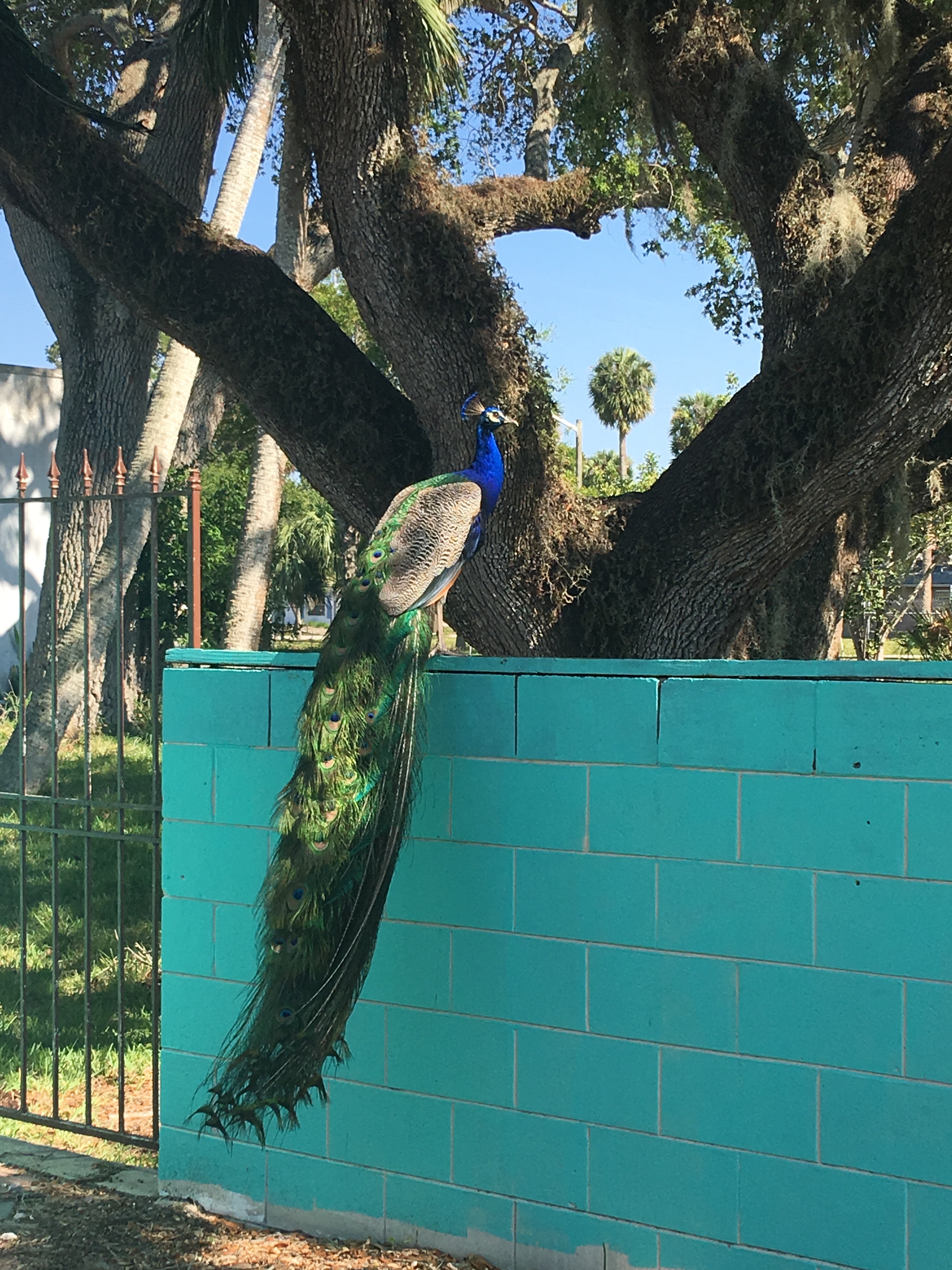
Peacock sitting atop wall, Orange Avenue, Ft Pierce, Florida. 5-8-17, JTLCrain Building Orange Ave, Ft Pierce, home of the peacocksOrange Avenue, Ft Pierce
I love Ft Pierce. Every time I’m there I feel like I see a good friend I haven’t seen in awhile: “Old Florida.”
Not only does Ft Pierce have a rich history, a great revived downtown, sit along the beautiful Indian River Lagoon, offer a river and sparkling beaches not contaminated by Lake Okeechobee discharges, the city just has so much CHARACTER.
Yesterday was an absolutely gorgeous day and as I drove past the iconic Crain house on Orange Avenue, decorated with special tiles and styles, my eyes locked with a peacock. I was captivated and pulled over my car to take a look around. Numerous birds crossed the busy street, jumped in the large oak trees, loudly calling to their mates. The busy cars darted around corners, merging off US1, and then stopped politely and patiently as the peahens, especially, decided if they really wanted to cross the road.
It was quite a sight.
I winced a couple of times thinking this was the end for one or more of the birds, but somehow there was a consciousness, an awareness, and the dance between the cars and the peafowl appeared almost scripted, as if a greater power were watching, maybe even intervening…..
“This is awesome,” I thought. Just how did this come to be, I wondered. I saw CRAIN on the eccentric, large building where the peacocks were gathering. I knew of the gentleman because I had actually called once years ago to inquire about the birds….But who was he really? When I got home and researched, this is what I learned:
Jack Crain’s obituary photo, St Lucie County.
Jackson Crain, Obituary, Legacy.com
Fort Pierce, FL
Jackson Crain, age 90, of Fort Pierce, Florida, passed away at his home on October 17, 2016.
Jack was born in East St. Louis, Illinois, and has been a longtime resident of Fort Pierce. Jack attended school in St. Louis before serving in the United States Army for a brief period of time. After being discharged he went to work for the railroad in Missouri. While in Missouri, Jack met Mary Lee Steinhoff, whom lived next door to his aunt. He married her February 9. 1952. After moving to Orange Avenue in Fort Pierce, Florida, Jack opened Buccaneer Building and Tile Company, and American Travel Agency, which he opened and operated along with his wife Mary Lee for 29 years. Jack also served as a Scout Master for the Boy Scouts of America.
Jack was a member of St. Anastasia Catholic Church, and had an affinity for peacocks and peahens, which he raised at his home on Orange Avenue. He also enjoyed coin collecting, traveling, and collecting knives, swords, fine art and paintings from around the world. Jack and Mary Lee traveled around the world nine times.
Jack was the devoted and loving husband of Mary Lee Crain for the past 64 years; beloved brother of Margaret Ray of Enterprise, AL, Dorothy Cardinale of St. Charles, MO, Hazel Dalton of St. Louis, MO, and Richard Berthold Crain of Orlando, FL; and many nieces and nephews.
Thank you to Mr Crain for watching over your legacy of beauty that makes Ft Pierce an even a cooler place. I promise to be careful when I see one of your birds crossing the road!
Tarpon Fishing, Kent Hagerman 1893-1978. Courtesy, Sandra Henderson Thurlow.Fishing map of McCoy Bros. SLR/IRL date unknown, notice the extensive tarpon fishing grounds, Thurlow Archives.Tarpon on the line! Dave Preston
If we look into the mirror of history, we begin to see…
We begin to see how we destroyed one of the most famous and beloved inland fishing waters in North America and how we learned to do better. And if we are able, in time, not only to do better, but to return “health and glory” to the St Lucie River/Indian River Lagoon, it should be the tarpon, not the sailfish, that becomes our symbol, our king.
The first formal fishing club documented in Stuart was the 1916 St Lucie River Tarpon Club. The late 1800s and early 1900s were an era of great fame for the St Lucie River, build upon President Grover Cleveland and other presidents fishing trips to the area. Yes, the St Lucie was known as the “Fishing Grounds of Presidents.”
Ironically, at this same time, the Commercial Club, that evolved into today’s Chamber of Commerce, was promoting not just Stuart’s remarkable fishing, but also enthusiastically encouraging and awaiting the completion of the St Lucie Canal.
SFWMD canal and basin map. C-44 canal is the canal most southerly in the image.
“Once the muddy water flowed into the St Lucie River, they began to realize that the canal was not the blessing they envisioned,” writes Sandra Henderson Thurlow. Historian Alice Luckhardt more directly notes, “at one time tarpon were often caught in the St. Lucie River, but “disappeared” from those waters soon after the opening of the canal system to Lake Okeechobee in 1923.”
Ingeniously, and with more insight, in the years following the loss of tarpon and other river fish as seen in the McCoy map above, the ocean-going sailfish was marketed to replace the tarpon and become “the most prized fish of all…” as well as in time the symbol for both the city and county governments.
The magnificent Silver King? Just a dying memory, or no memory at all…
By the mid 1930s the Chamber of Commerce began publishing the “Stuart Fishing Guide.” In 1941 the largest sailfish run in Florida’s history occurred off the St Lucie Inlet. Remarkable! More than 5000 sailfish were caught in a 90 day period. “Thousands were slaughtered only to be dumped in the river, carted off by garbage collectors, and used for shark bait.” Stuart as the Sailfish Capital of the world was affirmed, but as my mother states, if “Stuart’s fame was to endure, so was the need for conservation of the species.”
The idea for conservation/protecting the industry had been in the works, the Sailfish Club had been talking about it and a few sailfish were returned to the ocean…. But after the sailfish run of “41, the idea of an organized conservation effort was solidified, and Sailfish Club of ’31 updated their charter in “41 “to further and promote sports fishing and conservation in the waters of the City of Stuart and Martin County.” Visiting sportsmen were awarded and inspired to work for the most coveted bronze, silver, and gold lapel pins based on the size of the sail they caught and released, not killed.
This is a great story, but what of the tarpon?
I can see his giant, ancient, dorsal fin rising from the waters of a healthier St Lucie River/Indian River Lagoon. For me, no fish will ever compare. As we restore our rivers, it is he who shall be KING! 🙂
Close up of solidarity fish on Florida’s Capitol steps, Clean Water/Amd. 1 Rally 2-17-15.) (JTL)
My outdoor loving niece Julia Thurlow, Peace River trip, Martin County Bar Association. Family photo 2009.
If you are like me, sometimes you read the headlines and ask yourself, “what is going on here?” Florida Forever? Amendment 1? Senate Bill 10? House Bill 761? And today? Representative Matt Caldwell, probably running to replace Adam Putnam’s cabinet position in the Dept. of Agriculture, (certainly friendly with the wishes of US Sugar Corporation) proposing “more land funding” for Florida Forever? Hmmmmm? What does that mean? Is there a trap here? What’s the right thing? What’s going on anyway? How does all this work?
In order to try to answer some these questions, one has to take some time and study history….
In 1963, through the will of the people, the Florida Legislature began the Land Acquisition Trust Fund; in 1972 the Florida Legislature passed the Land Conservation Act for Environmentally Endangered Lands; in 1979 there was a major scandal as the Executive Director of the Department of Natural Resources was convicted of taking kickbacks from a land acquisition transaction and thus emerged the Conservation and Recreation Lands Program with “broader administration and oversight of land acquisition activity; ” “CARL” as it came to be known, expanded in 1981 with Governor Bob Graham’s “Save Our Rivers” and “Save Our Coasts” programs; all the while the citizens of Florida demanded such; Governor Bob Martinez continued the tradition by appointing a “Commission on Florida’s Future” that spawned the 1990 “phenomenal success” of the Preservation 2000 Act; the successor to Preservation 2000, through Governors Lawton Chiles and Jeb Bush was a name we all know and recognize, “Florida Forever.”
Florida was on a roll supporting the wishes of the citizens to preserve the state’s natural beauty before it was plowed down for more agriculture and development. Florida’s population was increasing exponentially…
So…..things are going “well.” The economy was growing. Florida was growing and the monies for land acquisition programs had evolved over the years to “tax the development that was causing a loss of open space in Florida.” Thus ironically the destruction of the state became the source of funds for conserving it. (Doc-stamp tax on the deed for real estate transactions ….) So when real estate was selling there were funds, when not there were not…
Fast forward to 2008. Some call it the Financial Crisis, some call it the Great Recession. Any of us who worked and lived through it, called it scary. During this time real estate values fell drastically. My husband and I in Sewall’s Point, Martin County, lost 40% of the market value of our home almost overnight. In St Lucie County it was as high as 65%.
So even though at this time in 2008 right before/during the giant crash, the state legislature “promised” funding to Florida Forever at former levels, but they did not give it as they couldn’t. So instead they raided trust funds like Florida Forever to “keep the State’s doors open….” and funding for Florida Forever stopped flowing with the drought of Doc Stamp monies.
After a long dry spell, as the economy slowly improved, and people realized things were bad, but that it would not be a repeat of the Great Depression of the late 1920s and 30s, some confidence returned and once again the people of Florida rose up and spoke out to their political leaders about what was important to them.
By 2014, Amendment 1 (Florida Land and Water Legacy) was put on the ballot and eventually the Florida Constitution by a citizens’ initiative with a whopping 75% plus approval calling for 33% of doc stamp money towards land and water conservation. Palm Beach County, the land of the Everglades Agricultural Area and more commissioners gone to jail for land fraud than all the rest, was one of the highest voting blocks. The message was clear. “We are back on our feet, we want to protect Florida, fund land acquisition as before!”
The state legislature did not do this, the numbers go up and down, but never near pre 2008, and never close to 33% of doc stamp money as the intention of the initiative, so now there is a law suit by the Florida Wildlife Federation and others to force implementation thereof. Continually, the legislature cries “separation of powers” and their right to interpret as “they know best….”
It is understandable that the recession has made us all more mindful, but this doesn’t mean we should forget about the environment, especially the St Lucie River, Indian River Lagoon.
Matt Caldwell? Yes, give more money to Florida Forever. But what is really behind your bill?
Joe Negron? He’s the real deal.
When I was a kid, one of my favorite commercials was Chiffon margarine. The message was that Chiffon tasted so much like butter it could even fool Mother Nature. When she found out she was mad and called on her powers with the animals surrounding her saying: “It’s not nice to fool Mother Nature….”
I say the same.
Stop fooling around state legislature and give us the butter. #SupportJoeNegron #SenateBill10
The wildflower I would like to remember in “all its glory” this Easter is the moonflower whose sweet fragrance used to fill Lake Okeechobee’s shores.
David Troxtell of the Marie Selby Botanical Garden in Sarasota writes:
“Not too long ago, Florida’s giant Lake Okeechobee would fill with rainwater and flood its southern banks every year during the wet season. The water’s slow journey through the Everglades’ 100-mile long “river of grass” and out to Florida Bay and the Gulf of Mexico would take months.
At the very beginning of this journey would have been a floodplain covered in a massive pond apple forest, completely blanketed in moonvine. Pond apple is a native tree which grows in regularly flooded areas, and is a preferred host for the moonvine. It has also become a rare sight in the state outside of the Everglades due to development, mostly agriculture.
The massive forest of moonvine and pond apples covering 32,000 acres along the southern edge of Lake Okeechobee was destroyed in less than a decade…” (http://selby.org/moonvine-morning-glory-family/)
What is exciting is that there is a resurgence of interest in reestablishing the pond apple also known as the custard apple which would inadvertently include the moonflower. The Art Marshall Foundation worked on such, but many were destroyed in the hurricanes of 2004 and 2005. Sarah Brown, a local South Florida photographer, has a show presently at the Lawrence E. Will Museum of the Glades. Many of her photographs feature the few remaining custard apple trees and moonvines. Zachariah Cosner, a student at University of Miami, is writing a book on the subject and I will be featuring his work more in the coming months.
So on this sacred Easter, remember, there is hope of recovering some of Florida’s wildflowers for which we are named. May we once again be Florida, “land of flowers.”
Courtesy of “Historic Jensen and Eden of Florida’s Indian River,” Sandra Henderson Thurlow
When I was kid growing up in Stuart, I remember seeing a lot of cottages. I loved these structures ~so simple, efficient, and adorable too. I remember cottages at Frances Langford’s Outrigger Resort just north of Sewall’s Point; I remember cottages in Rio along Dixie Highway; and I recall the cottages along Indian River Drive in Jensen at the old Pitchford Camp. Somehow the more run down they were, the cooler they appeared. A reminder of days long past before Martin County developed and we were all brainwashed of the need to build bigger houses and complicate our lives.
Today, when one hears the name “Pitchford,” one may envision a Martin County Commission embroiled in a decade of controversy, but this wasn’t always the case. In fact in the early 1900s the name “Pitchford” was a family name that defined “good times” of fishing, dancing, and playing shuffle board along the beautiful and healthy Indian River Lagoon.
Recently, I was invited by long time friend of my parents, Boo Lowery, to see his modern-day, old-fashioned, fish camp. Boo, himself, an “old-timer” is related to many of the early families of the Stuart area. Boo’s career as a respected contractor working closely with famed architect, Peter Jefferson, allowed him to become an expert in building, moving, and renovating homes.
In the 1980s when the cottages at Pitchford Camp were going to be demolished, Boo, who along with his wife Soo is a “lover of all things vintage” stepped in and saved five of the Pitchford Camp cottages. Over time, the little structures have been moved alongside land where a “borrow pit” (dug to build part of I-95) was located. This hole in the ground, today, is a serene pond in the middle of a pine forest, and a living museum housing the Pitchford cottages and of a way of life along our waterways that no longer exists.
It was so much fun going to Boo and Soo’s and today I am sharing some of my photos. While eating hush puppies and alligator, I told my husband, Ed, “I could live in one these cottages.” That I wanted to live in one of these cottages! He looked at me like I was out of my mind… Perhaps, he thinks I’m too soft and spoiled by “progress.” Maybe I’m dreaming, but I think I’d love it. I think I’d be as “happy as a clam…”
In any case, enjoy the photos of this very special place and thank you Boo and Soo for holding on to the old ways and for keeping our Indian River Lagoon history alive.
“Robert McClinton, “Doc, ” Pitchford was the only remaining Pitchford brother after Herbert’s death in 1988. When Doc died in December 2001, it was the end of an era. Doc tried to hold on to the old ways and was quite successful. The Pitchford holdings were like a time capsule surrounded by computer-age progress. Although most of the original Pitchford Camp cabins were demolished….”
Boo saved a few!
(Excerpt and photo below from my mother, Sandra Henderson Thurlow’s book “Historic Eden and Jensen on Florida’s Indian River.”