Monthly Archives: December 2022

Wrapping up 2022-St Lucie River Update

Tomorrow will be December 31, 2022. Today I share the most recent aerial photographs of the St Lucie River/Indian River Lagoon and even one around Lake Okeechobee.

It was a very cold Christmas season. According to the Stuart News, Stuart logged in at 39 degrees on Christmas Day! The cold system hovered for a few days causing intermittent rain and cloud coverage. These photos taken a few days later after it warmed up -on an incoming tide- reveal that since our last photo session, it appears the river is clearing up thankfully with no discharges from Lake Okeechobee in 2022.

AERIALS

-December 28, 2022 at 8:45am, west of Stuart, east side of Lake Okeechobee, near Barley Barber Swamp and FPL cooling reservoir, -sugarcane burning or a controlled burn??? Photographs taken by Scott Kuhns from SuperCub.

-December 29, 2022 around 2:30 pm, St Lucie River/Indian River Lagoon around St Lucie Inlet, Sewall’s Point, Sailfish Flats, wide view taken over Palm City. Aerials by Ed Lippisch from Vans RV. I am including all photos although some are very similar as each one shows something a little different. Remember you can click on photo to enlarge 🙂

Wishing everyone a very happy and safe New YearEve and let’s continue to work together for a great 2023 for the St Lucie River! 

A Florida River, St Lucie 1950-2050?

Looking up the North Fork of the St Lucie River towards what became Port St. Lucie 1957, Ruhnke Collection, courtesy Sandra Thurlow.

A Florida River, A Look at Wildlife 1950, by E.W. Dutton.

“This film shows a trip down the St. Lucie River with E.W. Dutton. Viewers see gators, blue herons, and many plants and flowers. The film also shows a red-shoulder hawk, sandhill crane, armadillo, black bear and cub, rattlesnake, land crab, and a gator being fed by hand. “Now a NO! NO! “Viewers see pelicans, mullet, cormorant, deer and a Florida panther.” ~Florida Memory.

Click on arrow below or the link here to view short film. 

Recently, my mother sent me this wildlife video filmed by E.W. Dutton, well known for his work of the St Lucie River and for area Chambers. His films bring one back to a time when not as many people lived here, and wildlife was prolific including animals unable to live along the river today such as deer, bears, and panthers. At this time the North Fork was a game sanctuary and conservation laws were respected in the South Fork.

E.W. Dutton, Ruhnke-Thurlow Collection

Wikipedia shows the population of St Lucie County as 20,180 in 1950.

And the population of Martin County as 7,807 in 1950.

The UF Bureau of Economic and Business Research projected population leads me to think that by 2050 there may no wildlife left anywhere in the region of the St Lucie River unless we curb development, work to “wild” our yards, work to live with wildlife rather that eradicate it, get more serious about highway over and underpasses and promoting and supporting the Florida Wildlife Corridor, including parts of Martin and St Luice County. Let’s make 2023 a turn in that direction! Kudos to the Loxa-Lucie Headwaters Initiative in Hobe Sound that added lands this year.

PROJECTED POPULATION COMPARED TO 1950 ST LUCIE RIVER REGION

St Luice County:  1950 population 20,180; 2020, 329,226; high projected  population by 2050, 601,400.

Martin County:  1950 population 7,807; 2020, 158,431; high projected population by 2050 – 277,700.

*Sources: Wiki and UF Bureau of Economic and Business Research

12-27-22 bio E. W. Dutton

Visual Update St Lucie River 12-20-22

I wanted to provide a visual update of the St Lucie River/Indian River Lagoon. Even though the river looks dark and silty, as 2022 comes to a close, we remain fortunate that there have been no major discharges from Lake Okeechobee to the St Lucie River since 2018 and no discharges to the St Lucie this year even though Lake Okeechobee got very high -maxing out at 16.51 feet.

Recently, there has been quite a bit of rain in Martin County. This follows the rains of Hurricane Ian and Hurricane Nicole. Thus the river looks dark and silty from weeks of runoff. The runoff now is coming from surrounding lands as well as C-23, C-24 and C-25 out in the IRL at Ft Pierce. There are also hundreds of old ditches that dump into the St Lucie River running though creeks such as Dansforth, Willoughby, Warner and others.

Thankfully the Indian River Lagoon South project is underway by the ACOE and local sponsor SFWMD to offset the destruction of the major canals of the Central and Southern Florida Plan. If things go well and the economy and political will remain in place, the remainder of these projects should be complete in ten or fifteen years. The C-44 Reservoir and STA in Indiantown, Martin County is complete.  Ten to fifteen years sounds like a long time, however, these  are gigantic, expensive  projects working to undo gigantic problems as our population skyrockets.

In the meanwhile we should be working on going septic to sewer where necessary and improving our yards by using little grass, fertilizer, or pesticides;  planting more native and Florida Friendly plants; using less water, picking up dog waste; and realizing everything we put on our laws or fertilize -crops and/or yard plants- ends up in the water ways! We have to be part of the solution. Don’t expect the government to do it all.

AERIAL PHOTOS ST LUCE RIVER UPDATE

Ed Lippisch, my husband, and Scott Kuhns, our dear friend, took the aerials  I am sharing today. The river does not look great due to so much rain. Thank goodness there are no Lake O discharges on top of this “local runoff.” Of which it really is not! This runoff has been mainlined here through canals of the Central and Southern Florida Plan.

SFWMD canal and basin map.

Next year they both Ed and Scott will have been River Warriors for ten years documenting the St Lucie! As eyes in the sky they provide a wider view and inspire a wider net of recovery for these waters. My brother, Todd’s web site eyeonlakeo allows for full time satellite and data updates.

SCOTT KUHNS, SUPER CUB, December 16, 2022 around 9:40 am. St Lucie Inlet (Hutchinson Island) plume about 12 miles south past Peck’s Lake, (Hobe Sound).

ED LIPPISCH, VAN’S RV December 18, 2022 around 12:15 pm. Plume at St Lucie Inlet, and dark runoff waters discoloring the entire estuary even close to the inlet around Sewall’s Point and Sailfish Point, Hutchinson Island.

Most recent rain as shown in my rain gauge. Just under 4 inches around December 14.

12-21-22 Added Presentation from ACOE Periodic Scientist Call: Periodic_Scientists_Call_2022-12-20

Drainage of Witham Field, Stuart

Images below from Todd Thurlow’s “East Ocean Blvd. & Dolphin Drive 1940, 1958 time capsule flight” reveals the drainage of  Witham Field in Stuart, Florida.For some reason as I drive around, I am preoccupied with drainage. Over-drainage that is. I always remember my father’s high school farmer friend Mr Haddad saying to me: “Jacqui, we spent one-hundred years taking the water off the land and we’re going to spend one-hundred years putting it back on…” 

I have been wanting to write something about Stuart’s Witham Field for a long time.  I have flown out of it for years, Ed and I going up to take photographs of the St Lucie River/Indian River Lagoon. What a surprise when I finally figured out the ditch behind Ed’s hanger is part of the remains of Willoughby Creek! Aggg!

The land Witham Field sits upon was ditched and drained long ago and parts of the land the airport sits on held the headwaters of Willoughby Creek.

If you’re ever driving east past Witham Field on Monterey Road (714) at Kingswood Drive you’ll notice a fairly wide ditch. This ditch bends east, widening, and then getting skinny again, eventually going under St Lucie Boulevard, and then dumps into the St Lucie River.

-Screenshot of Google Maps showing canal along Monterey and Kingswood Drive dumping to the St Lucie River then turning right to gold course.Another canal goes all along the airport behind the houses on St Lucie Blvd. until the Sailfish Sands golf course. Curving around St Lucie Boulvard, which becomes Indian Street, one will see a restored fork or section of Willoughby Creek and next the bridge going over Willoughby Creek itself. This is the bridge where people often observe manatees.There are more ditches that are off Dixie Highway that lead back into the airport that one cannot see from the road.

-The surrounding lands, especially ponds around Willoughby Creek, once drained into Willoughby Creek. These ponds are long gone and the runoff waters have been directed into small reservoirs and ditches. Thankfully, Martin County has worked hard to improve the water quality in this area.

Below: Martin County completed a storm water treatment area and native plant storm water treatment area for Willoughby Creek in 2020. (Image MC)

It remains rather amazing to look back and think on what these lands in the “middle of town” used to be. Large ponds surrounded by wetlands, scrub habitat, and certainly areas of tall sand and slash pine.

Watch my brother Todd’s time capsule flight below to view old Stuart including the lands where the Witham Field sits. Once an oasis for birds, deer, gopher turtles and other wildlife, today it seems like it was always an airport. It wasn’t. 

To see the area of Witham Field go to 2:29 in video if you see it below, if not   CLICK HERE.

-Ditch on Monterey (714) and Kingswood  -Ditch/Canal on Kingwood -Ditch/Canal coming from Kingswood to St Lucie River. Water looks pretty gross.  -Other side of St Lucie Blvd. Outfall into St Lucie River. It’s at a speed hump. -Part of restoration of Willoughby Creek on Indian Street. This goes much further back.

-Not a great photo but you see the manatee sign at bridge over Willoughby Creek on Indian Street. The manatees love it here where it is warm and they are protected.

Draining Palm City

My recent blog post featuring my brother Todd’s time capsule flight of Palm City 1966 Then & Now received great interest. So today I am going to take the subject a bit further in our study of area canals that drain wetlands into the St Lucie River.

If you have never seen the 1940s Aerial Photos UF Collection, you must! These historic aerials were taken when the United States had new-spy plane technology. They are our earliest comprehensive, aerial wetland accounts of Martin County, St Lucie County, and all of central and southern Florida. (All the dark in the photos is little ponds and sloughs!)

Just recently, through the help of archivists at the South Florida Water Management District, I was able to verify important historic information regarding canals C-23, C-24 and C-25. Again, these canals were constructed as part of the Central and Southern Florida Plan after the great flood of 1947. What is most interesting is that these canals were dug atop already existing local drainage ditches…

According to the SFWMD:C-23: “Acquisition began in April 1951 and concluded in 1961. There was an existing creek and ditch known locally as the Bessey Creek Canal. The Corp’s As Built Survey is dated November 18, 1964.

*I would think this local ditch had been dug by the Palm City Drainage District.

C-24: Acquisition began in August 1958 and concluded in October 1962. There was a existing canal know as the Diversion Canal, which was under the jurisdiction of the North St Lucie River Drainage District and they converted their interest in the canal to the SFWMD in August 1958. The Corps’ As Built Survey dates June 22, 1962.

NO PHOTO for C-25. (1940 aerials do not contain the Belcher Canal as the plane did not fly that far north. There are later aerials of the Belcher Canals after 1940, but I am sticking with 1940 today! the Belcher Canal, now C-25 is starts in Ft Pierce at Taylor Creek dumping into IRL.)

C-25: Acquisition began in October 1949 and concluded in September 1962. There was an existing canal known as the Belcher Canal, which was under the jurisdiction of Fort Pierce Farms Drainage District and they converted their interest in the canal to the SFWMD in January 1961. The Corp’s As Built Survey is dated July, 8 1964.”

Full view 1940’s Aerials  1 & 2

For me,  it is important to know the history of these canals. The C-44 south, and connected to Lake Okeechobee is our greatest water quality nightmare, however C-23, C-24, and C-25 are also extremely destructive. Yes, they allowed great growth of agriculture and development,  but they, as all the canals of the Central and Southern Florida Plan continue to killing our environment and the wildlife that once flew, roamed, ran, hopped, and dug freely, not to mention water quality issues.

The ACOE and the SFWMD are in the process of Northern Everglades restoration through the Indian River Lagoon South component of CERP.  This is wonderful news! We must be mindful of this before we continue to allow more growth and development and more drainage within these lands.

Indian River Lagoon South an overview

C-23/25 Recevoir & STA under construction


SFWMD basin map for SLR showing C-canals draining lands into the SLR.

Palm City, FL 1966 Then and Now w/ Todd Thurlow

Today’s blog post is about western Martin County Florida’s Palm City. This post includes  my mother’s inspiration, my brother Todd’s  time capsule flight video, and my writing.

Palm City was once narrow strips of pine flatlands interspersed with hammocks, ponds, wide prairies, sloughs, sawgrass and cypress trees. Today it is a bustling part of Martin County due to the drainage of the C-23 canal on the north, and the C-44 canal on the south. When one attempts to unravel the long history of drainage of Palm City, it is helpful to think in three connected but separate levels: local, state, and federal. 

In 1919  the Palm City Drainage District was created. It was established for a local level as a special drainage district by the Florida Legislature with a lifetime of fifty years. It was primarily created to drain newly established Palm City Farms. Miles of canals and ditches were dug to drain into Bessey Creek, Dansforth Creek, and the South Fork of the St Lucie River. Some of these canals and ditches still exist today or have been incorporated into larger canals.

Palm City Drainage District Docs. 1919

Digging of the St Lucie Canal in the south began around 1915  lasting into 1926. It was dug by the Everglades Drainage District, State of Florida, from the South Fork of the St Lucie River to Lake Okeechobee. After the deathly hurricane of 1928, the federal government authorized widening and deepening the St Lucie Canal to create the Okeechobee Waterway also known as the Cross State Canal from Stuart, across Lake Okeechobee, to Ft Meyers. Doing so allowed the St Lucie Canal to conveniently function as the main outlet for Lake Okeechobee’s flood waters. Later, after the great flood of 1947, the canal became part of the Central and Southern Florida Plan and renamed C-44 becoming part of the giant Central and Southern Florida Flood Control System of the Army Corp of Engineers.

The great flood of 1947 called not just for the widening and depending of the St Lucie Canal and enlargement of its structures, but the federal Flood Control Act of 1948 authorized more canals, levees, and structures  to be built by the Army Corps of Engineers throughout southern and central Florida. Among the new canals were the C-23, the C-24 and C-25 canals of Martin and St Lucie counties -all discharging into the North Fork of the St Lucie River. The state asked for and supported this. The C-23 is the border between Martin and St Lucie Counties. Of course there were major unintended consequences that added to the discharges of the St Lucie Canal and the original Palm City Drainage District. This plethora of fresh, dirty water has all but killed the St Lucie River. Improving the health of the St Lucie is the goal of local, state, and federal restoration efforts today.

The video below created by my brother Todd begins in 1966 after all the aforementioned canals were constructed. It is easiest to see in a large format. You can either click on the YouTube image below or use this link to watch this remarkable Palm City time Capsule Flight!

*Click on link to watch video by Todd Thurlow

-Below: the federal government’s (ACOE) Central and Southern Florida Flood Control Project authorized by Congress in 1948 included C-23 on the border of Martin and St Lucie Counties, C-24, and C-25,- and enlarging the flood control structure along the St Lucie Canal. Once this system was built out it was turned over the state of Florida’s Central and Southern Flood Control District; however, the ACOE kept the St Lucie Canal now named C-44, for federal flood control. The Central and Southern Flood Control District, a Florida state agency that followed the Everglades Drainage District in 1949, became the South Florida Water Management District in 1977. -Below: A 1973 C&SFP update map, Army Corp of Engineers. Green never built thank God!

Celebrating the 75th Anniversary of Everglades National Park!

Yesterday, December 3, 2022, Ed and I drove to Flamingo in Everglades National Park for a very special day, the park’s 75th anniversary celebration. It was unforgettable! Today I share the event program, historic postage, and some of my photographs.

The event featured an open house of the newly renovated Guy Bradley Visitor Center, a rededication ceremony with a list of impressive speakers including ENP Superintendent Pedro Ramos, live music by once Artist in Residence in Everglades, Grant Livingston, historic re enactments of Marjorie Stoneman Douglas,  Ernest F. Coe, Guy Bradley, May Mann Jennings, Ruth Bryan Owens, and John Pennekamp. Under a  blue sky and perfect weather the crowd looked out over Florida Bay and could see white pelicans, brown pelicans, and a plethora of other wading birds in the distance. The mood was jovial led by ZooMiami’s Ron Magill -master of ceremonies. Throughout the day many noted the moving speech of President  Harry S. Truman at the December 6, 1947 dedication of Everglades National Park in Everglades City. We walk in the footsteps of giants…

-Historic time-stamped 1947 Everglades City envelope and stamp in celebration of the dedication of ENP. From the stamp collection of the late Thomas H. Thurlow Jr., courtesy of historian Sandra Henderson Thurlow.

“Not so often in these demanding days are we able to lay aside the problems of the times, and turn to a project whose great value lies in the enrichment of the human spirit. Today, we make the achievement of another great conservation victory. We have permanently safeguarded an irreplaceable primitive area. We have assembled to dedicate to the use of all the people for all time, the Everglades  National Park…” –President Harry S. Truman December 6, 1947

It was wonderful to participate in this historic day in 2022 that so many before us worked so hard to attain. We all hold the baton for remarkable  Everglades National Park!

HAPPY ANNIVERSARY ENP! 

-Click on image to enlarge

-Order of the Day & List of Speakers -President Truman’s historic 1947 speech -Historic Figures  -Superintendent ENP, Pedro Ramos beaming on this special day! -with Craig Van Der Heiden PH.D and wildlife dept. Miccosukee Tribe of Indians of Florida -With Ernest Coe as portrayed by Mr Lee Jacobs.-Manatee drinking fresh water running down seawall, Florida Bay.-Mr and Mrs Chauncey Goss, Chauncey is Chairman of the SFMWD -together with Sean Cooley, Communications Director for the SFWMD. Drew Bartlett, Ex. Dir, Libby Pigman, Reg. Rep., her husband, and fellow governing board members Ben Butler and “Alligator” Ron Bergeron also attended. -Juan Cueto, Executive Director, The Alliance of Florida’s National Parks, Superintendent Ramos, and Maimi-Dade County Mayor Daniella Levine Cava.-Col. Jamie Booth speaks on behalf of the ACOE.-Reenactment: Mary Mann Jennings presented the bill for Palm Hammock and Paradise Key in 1915. -Historic display showing Great Egret plumes- destructive fashion for ladies hats in the late 1800s and early 1900s. Guy Bradley was killed as Audubon’s first warden trying to protect wading birds from this terrible fate.-Great Egret photograph showing a bird extending its plumes during mating season, public domain. What a  sight to behold!-Video reenactment of Marjorie Stoneman Douglas who wrote the famous book River of Grass.

-Grant Livingstone and Ernest Coe. Ernest Coe, the major inspirer for the park, almost did not attend the 1947 dedication as he felt the park should have been larger as originally planned.-Tina Osceola, Sup. Ramos, Debbie W. Schultz, Shannon Estenoz, Talbert Cypress, Ron Magill right. (See program for titles)-Rep. Wasserman-Schultz, Superintendent Ramos, and Assistant Secretary of the Interior, Shannon Estenoz celebrate the rededication proclamation of ENP.


A Child’s Dream -A Hunt for the 1715 Treasure Fleet’s Riches

It started about two years ago when Ed’s young niece and nephew, Capri and Cole, came to visit. On our trawler, Adrift, they found the map “Shipwrecks of Florida and the Eastern Gulf of Mexico.” They stared asking about shipwrecks and treasure and pirates. Ed and I had to study up.

“…The 1715 Treasure Fleet was returning from the New World to Spain. At two in the morning on Wednesday, July 31, 1715, seven days after departing from Havana Cuba, all eleven ships were lost  in a hurricane along the east coast of Florida. Today, we refer to this area as the Treasure Coast.

Every time Ed and I saw Cole and Capri thereafter, they asked again about the pirates, the gold, the ships at the bottom of the sea. So this time when the family came for Thanksgiving I told Ed it was time we lead a treasure hunt and then visit Mel Fisher’s Treasure Museum in Sebastian. We could teach the kids about the famous Treasure Fleet of 1715 featured in the 1965 edition of National Geographic where Kip Wagner and Mel Fisher’s Sebastian, Vero, and Ft. Pierce finds created “treasure fever” all over the world. I ordered an inexpensive treasure chest, false pieces of eight, and colorful costume gems. I visited thrift stores for beads. I thought about how the pieces of silver and gold were stamped in Peru and Mexico and that the Spanish had colonized these areas only steal the riches back to the crown…

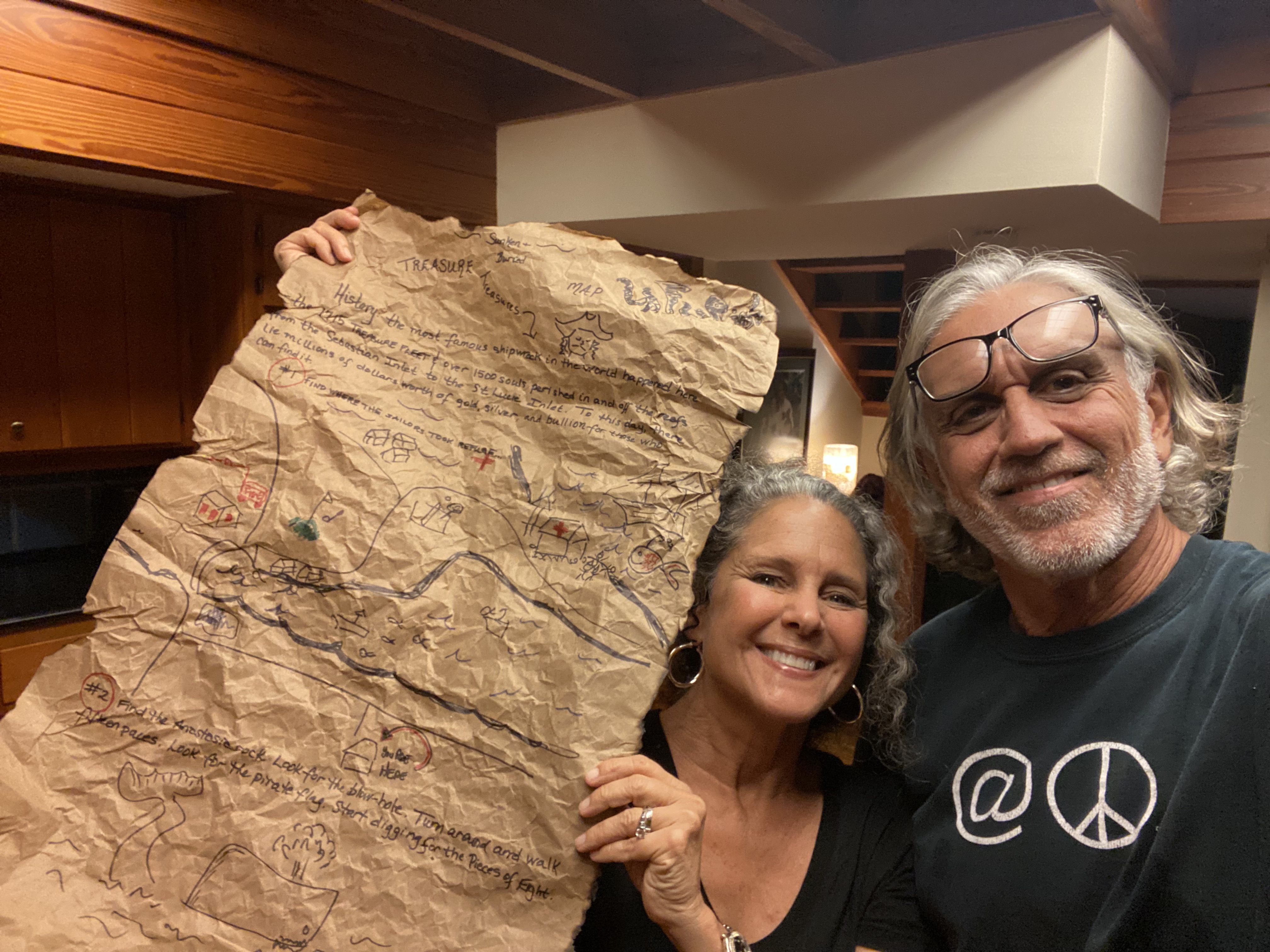
Ed’s first job was to crate a treasure map. He drew the figures and I wrote the history and clues. Ed even tore, crinkled, and burned the edges of the paper to make it look old.  WRITTEN ON MAP

History: the most famous shipwreck in the world happened here. The 1715 Treasure Fleet and over 1500 souls perished in and off the reefs from Sebastian to the St Lucie Inlet area. To this day, lie millions of dollars of gold, silver, and bullion for those who can find it.”

Clue #1 Find Where the Sailors took Refuge
Cule #2 Find the Anastasia Rock. Look for the Blow Hole. Turn around and walk fifteen paces. Look for the pirate flag. Start digging for the Pieces of Eight.

Ed’s second job was to go ahead of me and his family and bury the treasure chest at the House of Refuge. Ed did a heck of a job. Such a great job that once the kids found “X-marks the spot,” they dug, and dug, but could not find the treasure!

I was looking at Ed. I was glancing at Ben (Ed’s nephew) and Kelly (Ben’s wife). I couldn’t believe it!

“Ed!!!” I bellowed!

Although it was November, and Thanksgiving time, it was hot and humid.  A fog hung over Hutchinson Island as we drove over the Indian River from Sewall’s Point.

Now we all were getting nervous and Ed and Ben started digging for the treasure box. The kids stood by spellbound. It wasn’t as if they hadn’t given it a good shot.

-Ed and Ben taken over…-Cole tries to help.-Capri holds a map up for Ed to get a clue..“Well the kids moved the pirate flag and the metal bar I put over where I marked the booty.”  Ed whispered, so the kids would not hear. “Just find it! I replied.  “Keep the dream alive!”

Ben and Ed dug. And they dug. And they dug. This went on for at least fifteen minuets or longer. The hole was getting deep and I knew this is a “no-no” due to nesting sea turtles. I kept making Ben and Ed fill the hole back in. I heard a voice and realized the Keeper of the House of Refuge, Michael Philips,  had left his historic post to come outside and see what we were doing. I explained, apologizing. He laughed and was very kind.

Then it dawned on me that we may never find the treasure box. That it would sit and rot here at the historic house of refuge under the sands of time forever. The irony was unbelievable.

Sweaty and tired, Ed looked at me: “You’re going to kill me, aren’t you?”

I laughed and hugged him. “No, it’s actually very funny.”

Right at this moment Ben struck the treasure box. “Thump.” Cole and Capri screamed with joy and resumed their digging. Gold and silver coins were strewn across the sand as the kids fought to hold the bullion.  Success! Certainly a dream kept alive and that is all that matters.

Field Trip post treasure hunt:

-Mel Fishers Treasure Museum, Sebastian, Florida about an hour drive north of Stuart. You can take AIA where all the ships lie off shore! -The museum offer kids a fill in the blank treasure hunt questionnaire and once completed the kids get to choose a small gift from the gift shop. Carpi chose tiny binoculars and Cole chose a pirate ring. They also saw real pieces of eight and how expensive and beautiful the pieces were. This facilitated a lot of historical and present day conversation. -Capri and Cols stand before the 1876 House of Refuge, Hutchinson Island, Martin County. This setting was wonderful for our treasure hunt. Thank you!

-A scholarly article by Rick Crary about the 1715 Treasure Fleet.Â