I hope you and your family had a happy Father’s Day. The water was beautiful this weekend, so I thought today I would compare some aerial photos my husband Ed and I took this weekend to some we took in June of 2013 during the “Lost Summer.” No wonder we all fight for clean water and fewer discharges from Lake Okeechobee and area canals. What a difference!
Of course other than “history,” rain has a lot to do with discharges into the St Lucie River/Indian River Lagoon, and it has not been raining too much lately— thus the blue waters rather than the ugly dark brown plumes. It is important for all of us to understand why our paradise sometimes turns into a disgusting toxic mess so we can keep working for policy to change this problem.
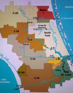
The first and worst part of the problem lies in southern Martin County—the C-44 canal built by the Flood Control District of the era and later the Army Corp of Engineers to connect Lake Okeechobee to the South Fork of the St Lucie River. This canal was connected in 1923 for agriculture and transportation. So now, not only is there the agricultural lands’ runoff from the C-44 basin that pours into the river, but also the periodic often huge releases from Lake Okeechobee. In spite of claims that this lake water is “only 30%” of total discharge water coming into the estuary, when it comes it is tremendous, filthy, and always a killer.
I think a decent metaphor would be that one could drink alcohol all time (from the C-23, C-24, C-25) and have problems like an alcoholic but function, however, if one downed two bottles of gin in a short period of time, one would kill oneself. Lake Okeechobee and its periodic huge slugs are death each time for our St Lucie River/Indian River Lagoon.

Next we must recognize the other problem-part of our canal system in the northern region…
After a tremendous hurricane/storm and flooding (because we are a swamp….) in 1947 the state of Florida and the federal government worked to appropriate monies for the Central and South Florida Flood Project which created the plumbing system we know today for all South Florida.
The part “we got” was the building of canals C-25, C-24 and C-23. The state and federal government acted like this was “just for flooding” but it wasn’t. It was also to allow for more agriculture and development in the region by draining the lands. (Mostly citrus and development of Port St Lucie). These canals were built and “improved” throughout the 50s and 60s and expanded the water being drained into the St Lucie River by about five times!
So now water from Okeechobee and St Lucie counties, and even water that had been flowing north into the St Johns River, through Indian River County and beyond— drains into the St Lucie River! (The headwaters of the St Johns River started flowing north in the marshes west of Sebastian and Vero—they have been directed to the SLR…)
Crazy isn’t it?
You know these “guys” —these politicians and business people, knew they were killing the river. They were just so driven by the pay-off of citrus/agriculture and cheap lands to sell….that they didn’t care…The river dies slowly so many of them did not see the “close to total death” —what we see today…but they knew what they were doing.
There were those who objected trying to protect the river’s fishing industry and wildlife….But their voices were not enough to stop the train….sound familiar?

The map above shows the “expanded watershed” in yellow and pink going into the St Lucie River. This is why I very much object also when I hear “how 70-80%” of the water polluting the St Lucie “is from our local watershed.”
Like we are supposed to feel responsible? Most of it’s not local!!!!! Plus it is the SFWMD’s job to oversee these canals. FIX THEM!
The moral of the story though is that the “local watershed” does not exist anymore….
“Wealth (agriculture and development) at the expense of the environment….” The story of our state.
Of course the grand irony is that we all came here for the “environment” ….the water, the fishing, the wildlife, the beauty…..
So here we are in Martin County living in a world where the pendulum swings between “paradise and hell.”
Paradise is not what it used to be, but it is still here. We saw some of it this past weekend…And we could bring back more if we really tried….If we want it, our job is to get more of the water coming into the St Lucie River/IRL back onto the land, going south, and returned or held north, and not draining or being released into our watershed.
Sounds reasonable doesn’t it? Well, the problem is we don’t have 30 years….or 50 years….like “the plan” (CERP) calls for now….(http://www.evergladesrestoration.gov)
There is alway hope we could do it faster. We must make hope a reality….all of us.
As newspaper man and famed environmentalist Ernie Lyons said: “What men do, they can undo…..and the hope for our river is in the hundreds of men and women in our communities who are resolved to save the St Lucie…” (Ernest Lyons, Editor and reporter, Stuart News)
This weekend I think we were all inspired! 🙂

_____________________________

