
It seems like every time I visit my parents, my mother has another cool map for me to look at. Recently she shared this map, a 1909-11 “Drainage Map of the Kissimmee and Calosahatachee Rivers and Lake Okeechobee, Florida.” The map was prepared under the direction of Captain J.R. Slattery, Corps of Engineers, U.S. Army. You can see at the bottom right of the map the document is listed as “House Doc. No. 137; 63rd Congress, 1st Session”.
To me what is interesting about the map other than the fact that the ACOE and our government were already planning and draining South Florida so long ago is the section to the east of Lake Okeechobee going towards the St Lucie River/Indian River Lagoon. It shows a “slough, “a pine forest, a prairie, topography, the Allapattah Flats, and other interesting features no longer around today… I think part of the “swamp” became Port St Lucie and parts of western Martin County…it show the elevations obviously taken for engineering future drainage, and it shows a “cane slough,” very close to the South Fork of the St Lucie River. How ironic with all the sugar cane around here today!
“Cane” according to my mother, meant tall/grassy swamp….not sugar cane. There is actually a road in Port St Lucie named “Cane Sough” that looks more like a concrete interchange than a swampy, grassy area. The cars roar by, and it seems like its been this way “forever”…it has not….
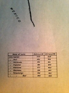
Also interesting on the map are the lake levels noted in Lake Okeechobee: 20.6 for “ordinary lake water” and 24.4 for “extreme high water,” as measured from the Atlantic Ocean. Today we measure from NGVD which is changing or changed to NAVD which is an entirely different story. Nonetheless, today the ACOE and SFWMD “keep”Lake O ideally between 12.5 and 15.5 feet so the man-made, ACOE-dike does not break and flood all of the agriculture and development south and around the lake.
What does the Bible say? “The wise man built his house upon a rock?” Well, we built ours upon a swamp!


_________________________
Thank you to family friend, Stephen Dutcher, who shared this map with my mother.
The St Lucie Canal, or C-44, was built beginning in 1915 and connected to St Lucie River in 1923.
The C-23, C-24 and C-25 canals were built in the late 1940s through the 50s as part of the Central and South Florida Flood Project. Google each canal along with DEP for a good history and explantion.
PSL tour of remaining cane slough: (http://www.cityofpsl.com/parks-recreation/parks/mariposa-cane-slough-preserve.html)
Note “Okeechobee is spelled with one “e” here…