Monthly Archives: July 2023

Aerial Update St. Lucie River to Lake O 7-29-23

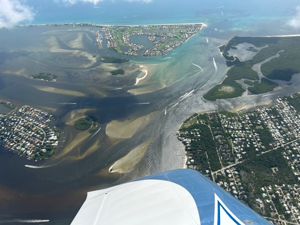
Northern Lake O algae bloom On Saturday, July 29, 2023, my husband Ed returned from flight with 103 aerial photographs of the St. Lucie River to Lake Okeechobee. When there are so many photographs it is difficult for me to decide which ones to include so I have shared most in gallery format.

The St. Lucie River continues to be darkened by C-23, C-24 and storm water runoff while Lake Okeechobee continues to suffer from cyanobacteria blue-green algae blooms primarily in the north. Ed said there was algae in the middle of the lake but that it was more like a “sheen.” Like gasoline on water.

Ed’s photos show algae on both sides of the St. Luice Canal (C-44), but none at S-80, St. Lucie Locks and Dam, and little visible in the lake -again just a greenish color- at S-308 at Port Mayaca lakeside.

The algae in north Lake Okeechobee is dramatic and looks more clumped than I have witnessed previously. Perhaps wind and rain? Strange…

The only good thing I can say is that the ACOE and SFWMD continue to recommend no discharges from Lake Okeechobee to the St. Lucie River. We’ll see about next week.

On July 25, my brother Todd Thurlow eyeonlakeo texted me that S-308 was open at 1656 cubic feet per second but S-80 remained closed. I would imagine this water let in from the Lake Okeechobee was for canal levels or water supply of agriculture. If I were growing crops I would not wish to accept this water as University of Florida Institute of Food and Agriculture Sciences UF IFAS had notes: “Cyanobacterial toxins can accumulate in crop plants, resulting in injury and yield loss; human health may be affected. Impacts of field crop exposure to cyanotoxins in irrigation water are unknown.

Known or unknown,  it can’t be good.

The historic role of agriculture supported by our state and nation is the primary reason the lake is in such awful condition today; this has been documented since 1969. (U.S. Geological Survey in cooperation with Central and South Florida Flood Control District two year study on chemical and biological conditions of Lake Okeechobee, Beyond the 4th Generation, Lamar Johnson 1974.)

On Saturday, July 29 the South Florida Water Management District recorded the lake level at 15.03 feet. Do not pray for rain…

LAKE OKEECHOBEE


ST. LUCIE RIVER, ST. LUCIE CANAL, S-80, ST. LUCIE LOCKS AND DAM

ST. LUCIE CANAL TO S-308 AT PORT MAYACA AND LAKE OKEECHOBEE, ONE PHOTO BACK IN STUART

Canal systems dumping polluted fresh water into SLR, SFWMD visual.


Original Little Locktender’s House – St. Lucie Canal

Locktender’s house at St. Lucie Canal lock #2 in the Everglades Drainage District. 1913 (circa). State Archives of Florida, Florida Memory.

I love this old photograph. I would think it must have been taken sometime between 1916 and 1925 when the Everglades Drainage District was constructing or repairing, (1924), the St. Lucie Canal. Yes, the lonely little house in the wildlands of a slash pine forest saw the the construction of the canal, the lock and spillway, the first locktenders, some wicked storms like the hurricane of 1928 causing the Army Corps of Engineers by 1930 to take over management of both Lake Okeechobee and the St. Lucie Canal. In 1937 the canal was rededicated as the “Cross State Canal, or Okeechobee Waterway.” It was deepened and widened for higher discharges and for more yacht traffic. By 1941 the St. Lucie Lock and Spillway was replaced as part of this expansion and the southern banks were drastically cut in the direction of the little locktender’s house. I can imagine the stories this little house would tell! Today we don’t have the little house, but we have the next best thing, my little brother!

Watch Todd tell the remarkable history of replacing the lock and spillway and the location of the original locktender’s house throughout the canal’s changes. Todd brilliantly uses historic aerials and images juxtaposed to Google Maps some shared by my mother Sandra Thurlow.

LINK TO VIDEO: ST. LUCIE LOCKS IN THE 1940s: EXPANSION PLANS AND THE LOCATION OF THE ORIGINAL LOCKTENDER’S HOUSE

References:

~The site plan: “U.S. Engineer Office – Jacksonville, Florida.  Sept. 1938… To Accompany Specifications June 27, 1939.

~The aerial photo with the locks under construction is dated 2/23/1940

~On Florida Memory the picture of the little house is titled cited “Locktenders house at St. Lucie Canal lock #2 in the Everglades Drainage District. 1913 (circa). State Archives of Florida, Florida Memory.

~1940 Aerials, U.S. Dept. of Agriculture

~Dr. Gary Goforth, 2014 History of the St. Lucie Canal

Early Locks, Thurlow Archives, Courtesy Sandra Henderson Thurlow.

2024 will be the 100 year anniversary of the St. Lucie Canal…

Courtesy Dr. Gary Goforth, History of the St. Lucie Canal 2014.

Aerial/Seagrass Update St. Lucie River also Lake Okeechobee 7-23-23


Today I share my husband Ed Lippisch’s aerial photographs and one video taken around 11:30am on 7-23-23. Also included in the post are photos of reemerging seagrass beds taken by my brother Todd Thurlow on 7-2-23. A wonderful thing although Todd estimates that just under 80 acres were in the area he visited.  

The St. Luice River/Indian River Lagoon is dark from rain, C-23 and C-24 discharge, and stormwater run-off, however most of the ocean looks gorgeous blue. You can even see the nearshore reefs. Seagrass and or macro-algae appear near the sandbars just inside the inlet. Not the 600 acres of yesteryear but some, and this is a good sign. There has been no discharge of Lake Okeechobee since April and that was a small amount with no algae. Nonetheless, it is never good for the river.

Lake Okeechobee shows no major algae blooms near S-308 as just a week ago at Port Mayaca although one can see the long green wisps like shadows in the water. This changes every day and you can follow at eyeonlakeo. This is Todd’s site and it shows Lake Okeechobee at 15 feet. Pray for no hurricanes.

There is algae on the inside gate of S-308 and some along the St. Lucie Canal also known as the C-44 canal as titled when it became part of the Central and South Florida Flood Control Plan of 1948. S-308 is overseen by the Army Corps of Engineers since 1930 but the South Florida Water Management District is involved spaying peroxide pellets on the algae when it gathers in big blue-green-gray rotting clumps as it did last week.  The algae dies but more than likely sinks releasing toxins. A conundrum most definitely….

Thank you to my husband Ed who is in his tenth year documenting our waters by air. All of working together are make a difference. We are watching and they know it. 

ACOE documented algae at S-308 on 7-13-23.


TODAY’S AERIALS, 7-23-23 by ED LIPPISCH

Sailfish Flats between Sewall’s Point and Hutchinson Island – note seagrass and macro algae in dark waters. 
Seagrass with macro-algae near Sandbar 7-2-23, Todd Thurlow.
Hermit crab enjoying seagrass 7-2-23, Todd Thurlow.
Underwater one can see the macro-algae atop seagrass. Macro-algae is increasing due to nutrient pollution and warmer temperatures. 7-2-23, Todd Thurlow.
St. Lucie Inlet with plume juxtaposed to turquoise Atlantic waters.
Roosevelt Bridge at St. Luice River, Stuart (L) and Palm City (R).
St. Lucie Inlet
Atlantic side
Blue green algae in St. Luice Canal
Attachment to FPL cooling pond – algae present
S-308 Port Mayaca at Lake Okeechobee attached to St. Luice Canal
Close up vague algae streaks in lake and in enclosed area locks opening to boat thoroughfare.
Canal systems dumping fresh water into SLR, SFWMD visual of Central and South Florida Flood Control canals of Martin and St. Lucie County.

Dramatic Lake O Algae Aerial Videos S-308 – 7-12-23

Date taken: 7-12-23 at 1pm/Location S-308 and C-44 Port Mayaca, Lake Okeechobee, FL/Pilot Ed Lippisch.

Three videos are included of the large cyanobacteria-blue green algae bloom off of S-308. S-308 opens into the C-44 (St. Lucie Canal leading into Stuart and out to St. Lucie Inlet.) This bloom waxes and wanes based on conditions but it “always there.” Nutrient pollution must be overcome.

S-308 is presently closed by ACOE. Keep your eyeonlakeo today measured at 14.87 feet.

~A picture speaks a 1000 words; a video…


Lake O SLR Algae Aerial Update July 2023

These aerials were taken over Port Mayaca and the St Lucie River/Indian River Lagoon by Ed Lippisch on 7-7-23 around 11:30am.

The algae bloom on Lake Okeechobee has lessened compared to two weeks ago however, now Cyanobacteria can be seen clearly on the inside of S-308 at Port Mayaca, Lake Okeechobee. This is from boats coming through the locks from Lake Okeechobee at S-308 as the first two photographs display.

“The blue-green algae continues east along C-44 up to the railroad track, about a quarter to a half mile.” Ed Lippisch.

Keep your eyeonlakeo today, Sunday, 7-9-23 at 14.86 feet.

Gates closed at S-308 algae backed up

Boats going through locks S-308 algae from Lake O enters C-44 aka St Lucie Canal

More photos:

S-80 St Lucie Locks and Dam, about 20 miles east on C-44, no visible algae

Burning field along C-44

C-44 Canal-Turnpike bridge

St Lucie South Fork area where C-44 canal meets Fork of St. Lucie River 1st constructed 1916-1924 by the Everglades Drainage District. Tuned over to ACOE in 1930.

Kiplinger Island at Palm City, St Luice River. Tremendous shoaling occurs here due to St Lucie Canal aka C-44 controversial for 100 years.

7-7-23: St. Lucie River/Indian River Lagoon view from Willoughby Creek approaching Witham Field. River is darker with runoff and canal waters but not Lake Okeechobee. No algae.

SLR/IRL

Most updated chart SFWMD showing inputs for agenda materials 7-7-23. Will be fully updated by 7-13.