On January 12, 2022, Ed sold the Baron and I entitled my post “Last Flight Old Friend.” Today I am hoping to make a new friend with Ed’s RV. To begin this friendship, on April 3, 2022, I sent Ed up to take photographs in RV flight.
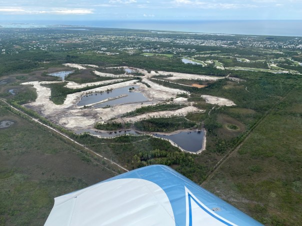
His aerials came out well; I wanted to share them today. They provide a striking look at some of the beautiful and changing areas of Martin County.
-Ed and his new RV
I.
-C-44 Reservoir located in Indiantown & being filled up by the ACOE.
II.
III.
-I am not sure what development this is being created, however, one can see the St Lucie Inlet and Jupiter Narrows as a reference. If anyone knows, please share. It looks to me to be located around Hobe Sound. 
IV. April 3, 2022, 11:30am
-The St Lucie River/Indian River Lagoon looks good. There have been no major discharges from Lake Okeechobee since 2018. Mind you, April is the near end of the dry season. The wet season begins around June 1. According to NOAA, the 2022 storm names are: Alex, Bonnie, Colin, Danielle, Earl, Fiona, Gaston, Hermine, Ian, Julia, Karl, Lisa, Martin, Nicole, Owen, Paula, Richard, Shary, Tobias, Virginie and Walter. I hope it is not foreshadowing that of of them is named “Martin.”
Ed’s aerials below show the effects of discharge on the St Lucie River/Indian River Lagoon near the St Lucie Inlet not from C-44 or Lake O, but from Canals C-23 , C-24 and local runoff. Seagrasses, or lack thereof, is a concern. Please see link for recent Army Corp updates: ACOE Periodic_Scientists_Call_Power Point 2022-03-29 2


Thank you Ed for taking photos! Maybe next time, if I get my nerve up, I’ll be up there with you! I have to say, my favorite plane so far was not the Baron, but the original “River Warrior”, the Cub. 🙂 No matter what you’re flying we will continue to document the St Lucie fighting for her health! 


Great photos. Could you illustrate or highlight those area where we’re getting the hazardous outflow on one of these. It’s pretty obvious, but at first I thought it must be cloud cover?
Hi Thomas, this outflow from C-23 and C-24 is a few miles away near the north fork of the st lucie river coming out of St lucie County for c-24, and the boarder of Martin and St lucie for C-23. Local basin runoff is from everywhere. I often attach basin map to my post showing the outfall areas. I will look for a link to add to this comment I am writing. Thanks for you question/comment. PLEASE SEE LINK: there is a basin map in this post after just a few photos. The canals are labeled and thus you can see the discharge areas. The photos Ed and I are taking are closer to Sewall’s Point and the St Lucie Inlet. Hope this helps.https://jacquithurlowlippisch.com/2021/12/25/beautiful-christmas-season-above-the-st-lucie/
Great pics!! Thanks for being our “eye in the sky”..!!
Thank you! Always!
Thanks for the photos. The are great. The documentation is invaluable. Many wishes safe and fun flying. Thanks Ed and Jacqui.
Thank you!