Monthly Archives: June 2021

Aerials 6-27-21 -St Lucie to Lake O

Yesterday, Sunday, 6-27-21 -at 2:15 pm, my husband, Ed, took a flight over the St Lucie River/Indian River Lagoon. In spite of significant local basin runoff, due to local rains, the river looked good.

Flying west -Lake Okeechobee at Port Mayaca showed no visible signs of algae from 1000 feet, however also on 6-27-21, Mike Connor, Indian RiverKeeper reported cyanobacteria within and around Port Mayaca’s S-308 gate; and on June 24, 2021, the Martin County Hearth Dept issued a BLUE-GREEN ALGAE BLOOM ALERT FOR THE WATERS NEAR PORT MAYACA. As expected,  The Department of Environmental Protection reports Algae in Lake Okeechobee at this time.

Florida Oceanographic gave a “B” for water quality in the St Lucie River for June 17-23.

Check out the SFWMD Ops_Position_Statement_Jun_22_28_2021

The ACOE reports the lake is at 12.66 feet 6-28-21 and there have been no Lake O discharges since April 10, 2021. Thank God! We continue to advocate for the health of the St Lucie and its residents. #NoLakeO

Enjoy the Flight! Enjoy the Water in the SLR/IRL! Ed and I visited Boy Scout Island on Saturday and the water was beautiful. The way Martin County is supposed to be! 

~Thank you Ed for being our Eye in the Sky since 2013~

-Sandbar St Lucie River/Indian River Lagoon-Sailfish Point, Sailfish Flats and Sandbar. Seagrasses are few, but there. Hopefully they will grow back if there are no Lake O discharges this year. Photo below is from Boy Scout Iland boat trip very near the Sandbar on 6-26-21.-Another view-Area between Sewall’s and Sailfish Points-Sewall’s Point visible on left-St Lucie Inlet at Sailfish Point- various photos -Great shot of St Lucie Inlet State Park, Jupiter Island looking north to Sailfish Point, Hutchinson Island. Here opens St Lucie Inlet from confluence of St Lucie River and Indian River Lagoon.-Ed taking a rare selfie! I think his first. “Thanks Ed!” 🙂-Lake Okeechobee at Port Mayaca, raining near Pahokee and south rim of lake. No visible algae but hard to see in this light. In any case, S-308 the gates at Port Mayaca are open only for water supply to agriculture and S-80 at St Lucie Locks and Dam remains closed thanks to the ACOE. Thus no Lake O water to the St Lucie. Hopefully they will remain closed for all 2021 and beyond!

My brother Todd Thurlow’s website EYEONLAKEO will keep you in the know!

Everglades 2021-Second largest nesting event since pre-drainage period in the 1940s

Words of Dr Mark Cook, Wildlife Ecologist | Restoration Scientist | Wildlife & Scientific Photographer | Public Speaker | Science Communicator/SFWMD

“As the rainy season finally kicks in after a late start, and the wading bird nesting now draws to a close, it’s time to reflect on a very successful nesting season. Final nest numbers and fledging rates are yet to be calculated but in general we can say this was the second largest nesting event (over 80k nests!) since the pre-drainage period in the 1940s, and very likely the most successful year in terms of the number of young birds produced! The photo here shows just one of the large flocks of young wood storks (note the yellow beaks not the black beaks of the adults) that recently fledged and are now recruited into the population. The late start of the wet season was certainly helpful because it allowed the vast majority of late hatching birds to fledge before the rains started and lost their food supply. It also extended the period of excellent foraging habitat which increases the probability of survival for these young, naive birds. It’s likely that all wading bird species nesting in the Everglades experienced a significant boost to their populations this year.” –Dr Mark Cook, 6-24-21, Facebook

Today I share photos of a helicopter tour taken June 18, 2021 under the direction of South Water Management Districts‘ Dr Mark Cook. Twenty-seven year veteran, JK Wells served as pilot, and Mr Sean Scully, Bureau Chief, Applied Science -Kissimmee River was a guest -just like me.

JK flew us “everywhere. This post will focus on Water Conservation Areas 1, 2, and 3. (WCA) and Everglades National Park. This flight was taken so that Dr Cook could document one of his final bird counts for the year. Most juvenile birds had fledged their nests. This is fantastic news. So we did not see the “super colonies,” some with up to thirty thousand birds, that were present just a few weeks ago -but we did see fledgling birds and parents and the Everglades landscape itself.  Spectacular!  I want to share these photos today.

~And kudos to the birds of 2021! So happy you had a great year! Thank you Dr Cook for letting me tag along!

-Pilot JK Wells, Mr Sean Sculley, JTL, and Dr Mark CookAt 7:00 am the machine rose like a dragonfly and West Palm Beach came into view. Within a short time we were over Water Conservation Area 1, also known as “Aurthur R. Marshall Loxahatchee National Wildlife Refuge.” This area is famous for its tree islands. -West Palm Beach below1. Water Conservation Area 1

-Tree island with remaining wading bird colony-Amazing tree islands in WCA1. “Tree islands are important centers of biodiversity in the Florida Everglades; they have two to three times the plant and animal diversity of the surrounding wetlands. This high diversity is due primarily to their higher elevation relative to the adjacent wetlands. In the natural Everglades system, water levels fluctuated seasonally with rainfall, and tree islands were the only sites that escaped flooding during the wet season. These seasonally dry sites provided refugia and nesting sites for animals and allowed tree and shrub communities to flourish.“USGS -Another view of this remarkable habitat! -Large tree island amongst smaller ones. The difference has to do with soil type and topography. Aren’t they spectacular? Biodiversity reigns here. -Note dead Lygodium or Old World Climbing Fern below that has been treated, now dead hanging in tree islands.Below: “Loxahatchee Impoundment Landscape Assessment,” LILA, -“human-made tree islands.” This research will eventually help recreate the many areas that have lost their tree islands. 2. Water Conservation Area 2

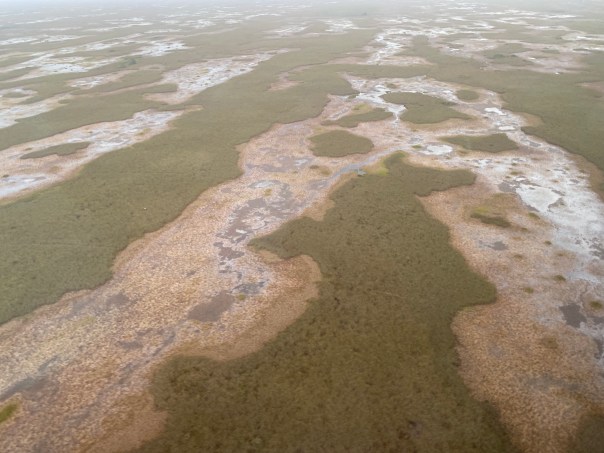
WCA 2 has experienced high phosphors and nitrogen levels going back to the 1960s. We could see the impaired landscape as we entered WCA2. The vegetation really started to change. The tree islands were no longer visible as the nutrient pollution has altered the flora and fauna. This is what happens when loads of phosphorus and nitrogen from agriculture and developed areas flows through pristine areas. They are lost, but there is hope…

-Leaving Water Conservation Area 1, going over the Hillsboro Canal into Water Conservation Area 2. Note vegetation changes compared to WCA1. -Hillsboro Canal-Note lack of tree islands. The vegetation has gotten so thick and tight Mark Cook says even an alligator cannot push though. There are many plants but mostly cattail, sawgrass, and willow. Dr Cook explained a program entitled “Cattail Habitat Improvement Project” or CHIP.

He showed us -large rectangles-cut into the thick vegetation. This was done a an experiment and is showing to be quite successful. Mark said just a few weeks prior, the birds were “going crazy” feeding here. These cuts-outs become “pools of life!” You can see them below.

-Thick vegetation WCA2 -CHIP- the wildlife and birds do return to these areas were vegetation has been cut out and improved. This gives hope for the future of WCA 2. 3. Water Conservation Area 3

Next we crossed the North New River Canal entering gigantic Water Conservation Area 3.

Here the lands are also impaired due to pollution but not as much as Water Conservation Area 2. One can still view here the Ridge and Slough that made up just about all south of the sawgrass prairie that today is the Everglades Agricultural Area.

-Note the small white specks – birds on giant tree island-A side view-Further west in WCA 3 – very clear Ridge and Slough pattern -Further Southwest above the Tamiami Trail – cypress domes and cypress forest. So pretty! -Juvenile birds feeding away from their nests

4. Everglades National Park – below the Tamaimi Trail. Dr Cook said the green in the water is water lettuce.

-This handout from earlier in the year shows the areas of the greatest bird nesting (red ovals and stars). Look at the numbers!

Final words of Dr Mark Cook

“This morning I completed my last survey of the breeding season and I’m excited to report that pretty much every nest in the Everglades (all 80k of them) has now fledged. Despite the start of the rains and the increased water levels there are still thousands of foraging birds in the freshwater marshes and along the coast meaning that the Everglades is still affording the young birds plenty of foraging opportunities which is critical at this early stage of life. The photo is part of a large flock of ibis in the western marl prairies of #evergladesnationalpark -“

-Dr Mark Cook, Facebook, 6-25-21

Thank you for JK for a very smooth flight!

Videos

  1. WCA 1-tree islands
  2. WCA 2-impaired Everglades
  3. Super colony in WCA3
  4. Cypress domes southwest WCA 3 in slow motion

At Our Front Door

My husband Ed took up the Baron today. His aerials are a potent reminder that even though the water has been looking “great” near the Sandbar in the St Lucie River/IndianRiver Lagoon, there is algae literally at “our front door.”

-Structure 308 at Port Mayaca, Lake Okeechobee 6-15-21, 1:18 pm -all photos Ed Lippisch-Just west of S-308 at Port Mayaca, Lake Okeechobee-North of S-308 at Port Mayaca, Lake Okeechobee along Rim Canal-Lake Okeechobee north of Port MayacaSt Luice River/Indian River Lagoon residents have been fortunate that the ACOE, due to the presence of algae, made decisions this 2021 not to discharge as much to the St Lucie. This began on April 19, 2021 when the ACOE S-308 “Sediment Study” was postponed due to high levels of cyanobacteria in the toxic blue-green algae at the S-308 gate. The HAB DEVIATION the ACOE had put in place made this possible.

Looking broadly, my brother Todd’s website EyeOnLakeO shows that although cloudiness has made satellite images difficult, the majority of the algae in Lake Okeechobee is presently on the west side, and the Caloosahatchee, unlike the St Lucie, has to take water to to maintain salinity levels. Thus they have algae in their river system right now.

As I sit here, rain is pouring down. We know dry season is over and rainy season has begun. What is critical is that the ACOE does not open S-308 and S-80 this year as our seagrass beds are just starting to recover after years of Lake O discharges. S-80 is the gatekeeper for the St Lucie River/Indian River Lagoon. For now, S-80 is closed. In order to keep it closed for 2021 please write the ACOE at: PublicMail.CESAJ-CC@usace.army.mil

SFWMD canal and basin map. C-44 canal is the canal most southerly in the image, note S-308 and S-80.

-S-80, St Lucie Locks and Dam now closedI am very pleased that Lake Okeechobee’s level is down to 12.50 feet; however, we know that could change quickly due to hurricane season. We must remain vigilant.

In closing, I want to share one cool thing that happened during Ed’s flight the thad nothing to do with algae. He saw the Goodyear Blimp!

Thank you Ed for continuing to be our “eye in the sky” since 2013! To view the SFWMD’s most recent comprehensive Ecological Report click here. There is a lot more to the system than us! 🙂

-Ed and Jacqui walking the bridge over the St Lucie River/Indian River Lagoon, 2021. Working for the betterment of the SLR/IRL ’til the end of time! 


This is the Life

On Saturday, June 5, 2021, Ed took me for a ride in the Maverick. Sometimes I am fussy, refusing to go if the waves are too big or the wind is too strong. But on Saturday, conditions were perfect.

It was a beautiful day, and I was grateful. I was grateful that the St Lucie River/Indian River Lagoon was not a toxic soup this year. I was grateful for the small amount of life in the river. Ed and I  put in at the Jensen Beach Boat Ramp and it was crowded. Resident wading birds were there waiting to see if someone would throw them a fish. I noticed, thankfully, the county had put up a sign since the last time Ed and I had visited. Once Ed and I got beyond the docks and out into the Indian River Lagoon the wind picked up and I held on tight! I Suddenly it seemed we were weaving in and out of other boats. I kept yelling “Be careful of manatees!”

“I’m in the channel!” Ed replied, looking at me  incredulously.

First we visited Boy Scout Island between Sewall’s and Sailfish Points as I wanted to check out the seagrass or lack thereof. It was growing! There were different kinds, one like a feather, (Johnsons) the other like a thick hair (Shoal). I saw blue crabs and hundreds of small snails. I was so happy to see this. I remember other times recently when there was not one bit of life. Still, it hurts that I have to “be happy” for such a small banquet of what I experienced in my childhood.

“If we can just hold off Lake Okeechobee releases…” I thought and was pleased the ACOE has done so for most of this year. Lake Worth Lagoon and the Caloosahatchee have not been so lucky.

Here, the rains began in late May and the river’s a little darker, not the turquoise blue you sometimes see. Nonetheless, the water looked good and and many families were enjoying themselves. Ed anchored being careful of grasses. I took a walk while he fished. Together we photographed the area.

-Boy Scout Island lies between Sewall’s and Sailfish Points near the Sailfish Flats and St Lucie Inlet -Seagrass beds slowly recovering  just off Boy Scout Island 6-5-21 -Excessive sargassum weed and macro-algae not as welcome to see a budding seagrasses-Head  of horseshoe crab – maybe molted. Good sign they are still here! -Thousands of snails leaving paths in the sand-A small hermit crab took someone’s shell. A nice one! -Little snails up close-Hand sized hermit crabs, old friends. Once there were thousands. We held races on the beach.-Boy Scout Island is a mangrove island with tidal areas for wildlife. We visited at low tide.Next, Ed and I got back in the boat and jutted through the Crossroads, me holding on for dear life again, -Ed in his glory! Spray on our faces! We arched off around the sea of boats onto a large sandbar close to the St Lucie Inlet.

It was a great adventure anchoring and then walking in the waist high water to the sandbar. I felt like I was a kid again roaming around, looking for shells, breathing in the clear air, lost in the happiness of the experience. We found quite a few fighting conch, pin shells, and clam like creatures all alive inside their shells! But no queen conch. Ed decided to go check that the anchor still held.

I wandered around losing track of time. I don’t think think there is anything more I love than this. I collected shells. Looked in holes. Birds rested and hunted for food. I even saw an osprey catch a fish in the lagoon’s shallow waters. The cloud formations were unbelievable.

When I finally returned to the boat, Ed was asleep. What a classic!

“This is the Life.”

This is the life indeed!-Pin shell and mollusk-Fighting Conch – orange in color -Tiny bit of seagrass and macroalge -Ed sleeps, Sandbar, St Lucie Inlet 


Giant Sand Pines! You Never Know What You May See…

 It was Memorial Day weekend and there was just enough time to go see that place…

Walton Scrub is easy to pass. Located at 10809 S. Indian River Drive between Jensen and Ft Pierce, the only clue that it exist is a sign and a small parking area. Look east for a marvelous view of the Indian River Lagoon. Turn west and find 33-hidden acres containing threatened and endangered plants found only in the habitat of scrub.  A half- mile self-guided interpretive trail is available on line.

~Ed agreed to go so long as I drove and if it only took an hour.

“So you really want to show me this scrub again? Haven’t you already taken me to places like this?”  

“Ed, I have but every place is different. You never know what you may see!”  

I became interested in scrub environments about three years ago. Scrub seemed more interesting once I realized how ecologically valuable it is and how humans have gobbled-up almost every inch for development. I have so many memories of running through scrub as a kid and today there is basically “none” left.

My childhood home in St Lucie Estates had been a sand pine forest, and there were many empty lots.  I remember sand pines, scrub oaks, gopher tortoises, scrub jays, and indigo snakes. I remember hot white sands and blue tailed skinks. For me, even today, the sand pine scrub represents my childhood.

And in this special preserve, this Walton Scrub, on this special day, Ed and I found the most enormous sand pine trees I have ever seen. Bent and enduring; tremendous and old. I felt as though I was looking at a ponderosa itself!

“Holy cow, Ed, look at the size of this sand pine!” I shouted out, running my hand over the rugged bark.

“Now that is big Jacqui.”

“Yes! It’s huge. Bigger than any I have seen. These are very special.” I marveled while Ed took my picture.“Amazing.” I thought.

We started down the Interpretive Trail learning about a former pineapple plantation, hickory trees, sand oaks, sand pines, and a host of other familiar but different flora and fauna.

“Look how white the sand is! Isn’t it cool?”

Ed smiled, we walked down the trail finding a menagerie of interesting things and a few more gigantic sand pines, as well as a gorgeous live oak.

“That is a beautiful oak tree Ed. Smile!”-Sand Pine cone must be exposed to fire to open making it harder to reproduce.-Another huge sand pine-Sand pine bark-Wind swept gigantic sand pine We walked under a fallen tree, then Ed saw something that really interested him. The railroad tracks. We could see that the tracks were being doubled. We talked about how much a high-speed train would change the Treasure Coast’s character and how things had changed it before, -like the first time Henry Flagler came though these sand dunes.

It seemed in no time we were through. Ed and my short but wonderful walk back in time was also a reminder of future change. I’m just glad, Ed and I saw the biggest sand pines we have ever experienced. “You never know what you may see.” And now, Ed agrees!

-Ed studies changes to the railroad tracks. -A sand pine forest of tall thinner trees-Rosary pea-Maybe a harvester ant pile-Prickly Pear delicious for gopher tortoisesGopher tortoises are keystone species creating habitat for hundreds of more animals-Gopher habitat- you can make you yard more appealing to gophers by letting parts go natural-Young sand oak and reindeer moss a classic feature of a scrub habitat-Sand pines are known for leaning due to wind-Pretty lichen atop oak bark- white and pink -Ed gets his photo before a giant sand pine too! -Budding hammock paradise tree


River Warrior Times 6-1-21

River Warrior Times 6-1-21

Summary

Since I last wrote #2, the St Lucie River has NOT been bombed and is in pretty good shape as the ACOE is not discharging from Lake Okeechobee thought the St Lucie Locks and Dam, S-80 structure. Algae is coming in through S-308 at Port Mayaca as this water is being used for agricultural water supply, but for now, it is relegated to the edges of the C-44 canal. Cities in Palm Beach County near the Lake Worth Lagoon have not been so fortunate as a cyanobacteria was found in their water supply right at the start of the Memorial Day weekend; and the Caloosahatchee on the west coast, which has been taking Lake Okeechobee discharges while the St Lucie has not, has pockets of blue green algae reported.

Things may start heating up even more for all waterbodies as June is the month one “normally” finds cyanobacteria in Lake Okeechobee.  May, this 2021, was very early to have such a large bloom. Please see my brother, Todd’s, website EYEONLAKEO for updates on both the St Lucie and now also the Calooshatchee daily discharge numbers  ~and much much more!

In case you did not view in the paper, a very remarkable letter to coastal residents was written by Colonel Jason E. Kelly, Commander, South Atlantic Division, ACOE. Never before have I seen a two page letter written by the ACOE regarding the estuaries and operation of Lake Okeechobee! This letter is really worth the read. Obviously, the Corp is listening.

I.

Photos of St Lucie River/Indian River Lagoon-

St Lucie River/Indian River Lagoon. Boaters enjoy at sandbar Memorial Day weekend, 5-30-21. The water from the lake and C-44 is not getting to the river as S-80 is closed.  All photos Ed Lippisch

Blue Green Algae not far away in C-44 canal kept inside by S-80 at St Lucie Locks and Dam.

Visible algae at the S-308, Port Mayaca, Lake Okeechobee leading into C-44 canal

II.

Water Advisory

West Palm Beach, Palm Beach and South Palm Beach. The best article to explain this situation was written by reporter Kimberly Miller in Sunday’s Palm Beach Post. The situation is complicated in that these cities receive their drinking water via surface waters. Sometime used is water brought in through Lake Okeechobee. In late April blue-green algae (cyanobacteria) was found in the canals leading into this area from Lake Okeechobee and immediately this input was shut down. The cyanobacteria found in Clear Lake is not microcystin we are so used to talking about, but another, cylindrospermopsin. Nonetheless, this cyanobacteria was documented in Lake Okeechobee in 2001 by the state algae task force. I think this situation will be a serious game changer for the state of Florida and it’s failure to address significant and meaningful water quality regulations.

III.

Algae in Calooshahatchee River

For me, the best way to follow the day to day water situations on the Calooshahatchee is to follow John Cassini, Calusa Waterkeeper. He has the support of pilots and drones to share visuals of the area. One of the main areas where cyanobacteria has collected is at S-79 structure and the SFWMD is using “innovative technology” to try to clean up the area.

S-79 algae bloom, Caloosahaatchee River, credit SFWMD


The River Warrior times is meant to be a summary of top issues.

Previous Summaries 2021:

River Warrior Times #1 

River Warrior Times #2