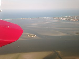


My photos of dark waters of the St Lucie River/Indian River Lagoon were taken on Wednesday, 3-18-15 as my husband, Ed, flew us to St Augustine for a Thurlow Family trip my mother organized, in “America’s oldest city.”
Seeing the destructive view of the discharges on our way north was not a good visual, but before we’d left St Augustine, I had learned that their river, very much like the Indian River Lagoon, is named “The Matanzas” meaning “River of Slaughter” in memory of Spain’s Don Pedro Menendez ‘ and his men’s decapitation of the shipwrecked colony of French Huguenots in 1565. During the massacre, the river “ran with blood…” (http://en.wikipedia.org/wiki/Matanzas_River)
Today our river runs with death as well, albeit a different kind…but we do not live in an age where if you are trying to displace someone, or don’t support their belief system, you chop their heads off….So what then can we do other than try to entice our dear government, to purchase land south of Lake Okeechobee to store, clean and convey water south the Everglades?
We can ask them to “document” what is happening….That sounds reasonable.
I have been reading the book: “Conservation in Florida, It’s History and Heros” by Gary L. White. Originally “the Department of Natural Resources,” the precursor to today’s Department of Environmental Protection, did what it could to protect resources rather just be in charge of permits to destroy such.
I think until the Department of Environmental Protection removes the word “protection” from its name, it still has an obligation to “protect” which also means to “document.”
Seagrasses—fish species—-coral reefs and fish species–oysters—-marine mammals—birds—-aquatic plants——–all that is being lost….
It’s pathetic that the agency is not doing this already. Documenting loss forces state and federal agencies to “do something.” Otherwise, the destruction just continues and everyone “forgets” life was ever there. We owe this to future generations if nothing else.
If you agree, would you please contact the “Department’s” new Secretary, who is a cabinet member of Governor Scott. Please ask him if the agency could document what is happening here is the St Lucie River/Indian River Lagoon or maybe “protect” it in some way since that word it is still in their name….
Jonathan P. Steverson DEP Secretary: 850-245-2011. Mr Tom Frick is in charge of Environmental Restoration for our part of the state; his number 850-245-7518. (http://www.dep.state.fl.us)
You can reference what Florida Oceanographic states on its website: (http://www.floridaocean.org)
In the St Lucie/Indian River Lagoon area, several “protected areas” are now bing impacted, including two “state aquatic preserves:”
“1. The Indian River Lagoon National Estuary,” running from south of Ft Pierce to Jupiter Inlet that is a National Oceanic and Atmospheric Administration (NOAA,) as well as an Environmental Protection Agency, (EPA,) “Essential Fish Habitat for Seagrass.” 2. Another area being impacted by the Lake Okeechobee discharges is the “St Lucie Inlet State Preserve Reefs, and Nearshore Reefs” nominated by NOAA for “National Marine Sanctuary Designation.”
The SLR/SIRL estuary,coastal-ecosystem and habitat has been documented by Dr Grant Gilmore, formerly of Harbor Branch, and others to be “the most bio diverse estuary in North America with habitat for more than 4,000 species of plants and animals, including 36 endangered and threatened species.”
–Where is the protection for these areas? Where are the agencies that are charged with enforcing these protections?


