12-4-17, ca. 2:45 pm, photos: Ed Lippisch & Jacqui Thurlow-Lippisch
The Army Corp of Engineers has lessened but not stopped Lake O discharges that started September 20th, 2017 just prior to Hurricane Irma. Perhaps as the discharges have gone on at such a high rate for a comparatively long time, the plume has had a chance to extend its territory. In yesterday’s photos, the dark, filthy plume is reaching clearly south beyond the exclusive Town of Jupiter Island.
Yesterday was a beautiful day, but the river and ocean waters of our entire region were ugly, possibly contaminated. How are we to enjoy our property and lives here?
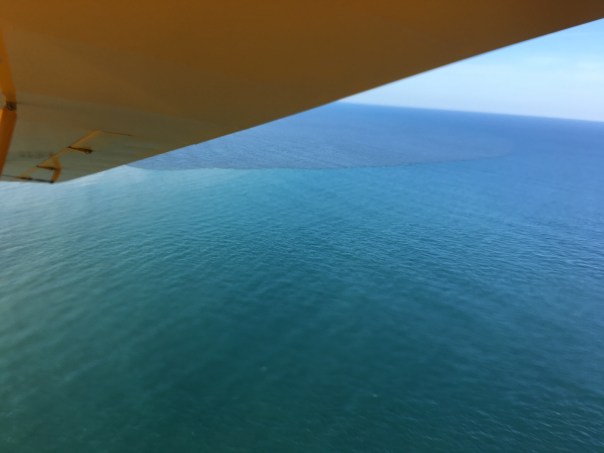
When viewing the aerials below, please note the blue, sapphire-colored water just on the edge of the discharge plume. Yes, of course all estuaries put forth darkened fresh water after a rain event, and Ed and I could see this occurring just south at Jupiter Inlet. Nonetheless, the black, gigantic plume that we repeatedly endure for the St Lucie River/Indian River Lagoon due to discharges from Lake Okeechobee is an aberration.
Please let’s all support Joe Negron and the public’s work to build the EAA Reservoir; clean & send the water south!
Lake O discharges: http://w3.saj.usace.army.mil/h2o/reports.htmLooking south along the southern most area of Jupiter Island.Looking north along Jupiter Island-dark ocean waters. Jupiter Narrows an extension of the IRL on left.Plume -looking north along Atlantic coastEdge of plume; note clean sapphire colored water juxtaposed to dark Lake O/canal plumeAnother angle, Jupiter Island, looking south-blur due to wind and camera movementBack at St Lucie InletIRL, note bare bottom. This area is known as the Sailfish Flats and once had hundreds of acres of seagrass beds.The Sandbar, a popular weekend recreational area for boaters, especially families, surrounded in dark Lake O discharge waters. This is a health issue.Barren Sailfish FlatsSand bottom with no seagrass between Sewall’s Point and Sailfish Point. An area once teaming with life.The Crossroads — no seagrass beds just sand bottomIRL looking northSt Lucie River near St Lucie Inlet dark as coffeeNorth of St Lucie Inlet the plume covers near shore protected reefs as it does south of the inlet.Blue!The plume as viewed from under the wing of the CubPlume edge: The tainted water we are given by our government; the blue –the water we should have by God & Nature.
Jacqui, thank you for all these photos and for your dedication….so frustrating, our family is at a loss as to what else we can do….I have donated to causes and written senators, reps, governor and get typical replies, which amount to no help at all, basically….We have lived in Martin County since 1974, and all disgusted by this water quality issue….
Thank you for writing Donna. This does make a big difference. It is unbelievable the difference between 1974 and 2017. All the best to you and your family.
I am at a loss of what i can do too. A few weeks ago a student from FIT came in and said its true— their studies proved that sea grass thrived on calcium carbonate–exspecialy turtle grass(you can bet these studies will get throwed in the trash) I have been saying this for years . It is like government lying and stealing is the norm. Here they are about to get 300 million to fix the lagoon. Most of this money is going to go to dredging new and existing yacht basins—that nobody wants. Muck has always been decaying organic material but in order to dredge new yacht basins useing tax dollars they reclassified muck as being 80% clay. Water QUALITY (not quanity) is the issue there. Nothing cleans water like hydogen peroxide and calcium peroxide that comes from water churning in shells. Jacqui if they wasted billions and sent the water south—then what? it will still be dead as hell there with NO sea grass.


This is a disgrace. Thank you for your perseverance.
Thank you for your comment Stephanie.
Jacqui, thank you for all these photos and for your dedication….so frustrating, our family is at a loss as to what else we can do….I have donated to causes and written senators, reps, governor and get typical replies, which amount to no help at all, basically….We have lived in Martin County since 1974, and all disgusted by this water quality issue….
Thank you for writing Donna. This does make a big difference. It is unbelievable the difference between 1974 and 2017. All the best to you and your family.
I am at a loss of what i can do too. A few weeks ago a student from FIT came in and said its true— their studies proved that sea grass thrived on calcium carbonate–exspecialy turtle grass(you can bet these studies will get throwed in the trash) I have been saying this for years . It is like government lying and stealing is the norm. Here they are about to get 300 million to fix the lagoon. Most of this money is going to go to dredging new and existing yacht basins—that nobody wants. Muck has always been decaying organic material but in order to dredge new yacht basins useing tax dollars they reclassified muck as being 80% clay. Water QUALITY (not quanity) is the issue there. Nothing cleans water like hydogen peroxide and calcium peroxide that comes from water churning in shells. Jacqui if they wasted billions and sent the water south—then what? it will still be dead as hell there with NO sea grass.
This is one of the saddest things I’ve seen in a long time
https://www.fieldandstream.com/catastrophe-in-everglades-and-how-to-fix-it
This is the best article I have seen on this problem.
Thank you for posting this link! Yes!