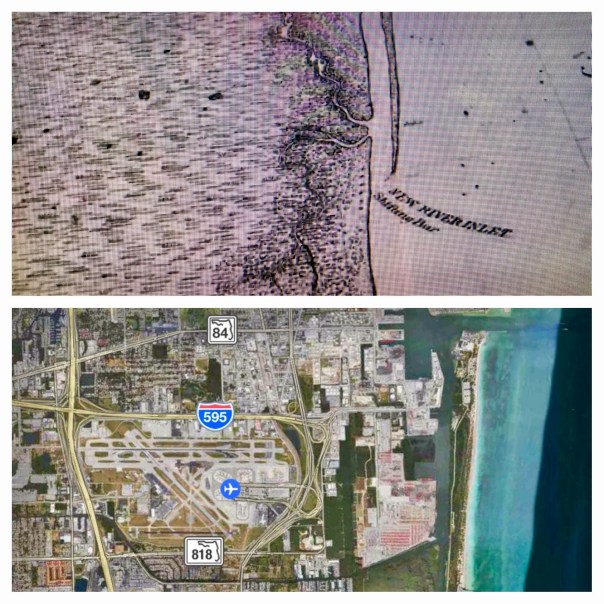
Today I am sharing two creations of my brother, Todd Thurlow. Entitled “Ft Lauderdale House of Refuge/Life Saving Station,” and “Short Version,”they were originally for my mother, Sandra Henderson Thurlow and Timothy Dring’s “Image of America, U.S. Life Savings Service” book presentation at the Elliott Museum.
For me, Todd’s videos are mind-boggling as they bear witness to how much and how fast we humans can change the environment. Like an army of ants, we organize; we build; we destroy; we create…
By comparing and contrasting Google Earth maps of today with historic maps from 1883, 1887, and 1935, Todd’s “time capsule flight,” takes us through time and space to see the shifting sands of the multiple New River Inlets; Lake Mabel that morphed into Port Everglades; remnants of the forgotten Middle River that spread and contracted into new canals and developments; and of course, for mom, House of Refuge #4, that once rested north of a New River Inlet that today we can see is completely filled in, while beach-goers relax in reclining chairs like nothing ever happened!
Maybe one day we humans can use all this energy and ability to really fix our waters that have been destroyed during all this construction? Wouldn’t that be a dramatic video?
In closing, in the early 1900s, the New River… that was believed by the Seminoles to once be an underground river that collapsed and the Great Spirit revealed during an earthquake… was selected by modern-day humans as the “natural channel” to connect two of the largest drainage canals from Lake Okeechobee to the Atlantic Coast, the North New River/South New River, and the Miami.
Please watch and enjoy Todd’s videos below!
Long Version with old New River Inlet:
(Link to video: https://www.youtube.com/watch?v=Ge1bCV5Tz5Q)
Short Version:
(Link to video: https://www.youtube.com/watch?v=oYWga93XL3w)

1936 historic write-up, Francis H. Miner, Federal Writer’s Project Ft Lauderdale, https://www.broward.org/library/bienes/lii10210.htm
Click for enlarged images:


To contact Todd: http://www.thurlowpa.com and you can access all of Todd’s videos here: http://maps.thethurlows.com.
Jacqui, I think you’ll love Tom Friedman’s new book “Thanks for Being Late”. A world view of incredible changes and stress. Cheers, Wayne
Sent from my iPhone
>
Thank you Wayne. I will look it up!!!
Jacqui, thanks so much for the Ft. Lauderdale beach historical contrast to today. My family will be very interested.
I remember going to the beach bonfire to burn the old Coast Guard Station; I suppose it was the House of Refuge. That was sometime in the early 1950’s.
Warm regards,
Dick
Dick Landrum
2949 SW Cornell Ave.
Palm City, Fl 34990
772-287-4930
Dick@LandrumSoftware.com
Glad to hear. Thank you Dick. I bet they have a great story.
Facebook Comments
Darrin Smith When it’s gone it’s gone. Martin County better save some green spaces.
Unlike · Reply · 1 · 5 hrs
Jacqui Thurlow-Lippisch
Jacqui Thurlow-Lippisch Agreed!!!!
Linda Schilling Mitchell
Linda Schilling Mitchell Having lived in Ft Lauderdale from 1951-1991, it was quite interesting to see the transformation. Greed fed progress that makes it what it is today. History repeating itself…
Unlike · Reply · 4 · 4 hrs
Blake Faulkner
Blake Faulkner Thanks for sharing this Jacqui. I was born in Ft. Lauderdale in the 1950s and I saw huge changes in Broward County when I was a kid growing up there. Your video started down at Dania south of Port Everglades and it showed that there was a natural inlet there on old maps. I never knew that.
It also showed the Dania Cut-Off Canal that I lived near and fished in and boated in with a 14 ft Alumacraft & 14hp O/B that we kids would take all the way to Dania Beach from west of I-95. I lived off Griffin Road just east of 441 (not far from the Seminole Reservation Tourist Center on 441). The Dania Cut-Off Canal connected with the South New River Canal out by 441. The North New River Canal was paralleled by SR 84 that became I-75 running west until it crossed US 27 heading for Belle Glade.
At about 1:34 on your video it showed the old House of Refuge station at the north end of Ft. Lauderdale beach. That is now the still naturally preserved southern section of the Hugh Taylor Birch property (I think). Sunrise Blvd crossing the Intracoastal Wtwy is just north of that property and then Hugh Taylor Birch State Park is just north of Sunrise Blvd along A-1-A. Back in the 1960s they built a pedestrian tunnel under A-1-A to help beachgoers cross A-1-A safely to the HTB state park. That was a fun place for kids in the 1960s with a canoe concession and actual freshwater lagoon on the property. Possibly fed by an artesian well?
Unlike · Reply · 2 · 4 hrs
Hide 11 Replies
Linda Schilling Mitchell
Linda Schilling Mitchell Blake- I thought the House of Refuge was further south near Bahia Mar where the old Coast Guard building use to be. I remember playing around there when I was little.
And Birch State Park was the best when the train still ran
Like · Reply · 1 · 4 hrs
Blake Faulkner
Blake Faulkner Check that first video again at that 1:34 time mark. I’ll look again but I’m pretty sure the road shown there is Sunrise Blvd. The old inlet that was filled in is about where Bahia Mar is. And the old Coast Guard station was. I always wondered what those pile of rocks were there when I was a kid. Part of the old inlet jetty. Who knew? Who could have imagined? Nobody cared about history then anyway. Nobody I knew did.
Like · Reply · 1 · 4 hrs
Marty Baum
Marty Baum The Ft. Lauderdale #4 HOR was built in the wrong location. The longshore current was reversed and the offloaded rafts of material moved north, and then broke up.. losing everything that did not float. The material grounded itself about 1.5 miles north …See More
No automatic alt text available.
Like · Reply · 3 · 3 hrs
Marty Baum
Marty Baum Here is the return of said mule.. The first attempt failed as the block and tackle was not strong enough. None the less, with a couple of men, one mule, and block and tackle, they drug the HOR down the ocean dune.. with the “owner” of the property where the Station was built and vacated from screaming to leave it there, it was rightfully HIS.. and he was right, but ignored.
No automatic alt text available.
Like · Reply · 2 · 3 hrs
Marty Baum
Marty Baum Daily Journal in the hand of Stephan Andrew.
Unlike · Reply · 3 · 3 hrs
Marty Baum
Marty Baum somewhere, I have a hand drawn map that locates Ft. Lauderdale HOR, in relation to Stranahan’s Ferry, and the road from Lantana to Lemon City..
Unlike · Reply · 3 · 3 hrs
Jacqui Thurlow-Lippisch
Jacqui Thurlow-Lippisch Blake your insights are priceless! Thank you.
Like · Reply · 2 · 3 hrs
Jacqui Thurlow-Lippisch
Jacqui Thurlow-Lippisch Unbelievable Marty!!!!!!Cool & thx!
Like · Reply · 2 · 3 hrs
Jacqui Thurlow-Lippisch
Jacqui Thurlow-Lippisch Sandra Thurlow
Like · Reply · 1 · 3 hrs
Linda Schilling Mitchell
Linda Schilling Mitchell Additional information-
O’Neill was keeper of the house in November 1891 when the station was skidded a mile-and-a-half down the beach to where it was originally supposed to be. The New River station was built in 1876 in the wrong location because the …See More
Like · Reply · 1 · 2 hrs
Blake Faulkner
Blake Faulkner Here is an excellent video production about Hugh Taylor Birch State Park with some very interesting historical information about Hugh Taylor Birch and why the land remains preserved as a state park to this day………..https://www.youtube.com/watch?v=fNdsVQvl538
Go Riverwalk Salutes Hugh Taylor Birch State Park
YOUTUBE.COM
Like · Reply · Remove Preview · 1 hr · Edited
Jacqui Thurlow-Lippisch
Write a reply…
Blake Faulkner
Blake Faulkner Oh yeah…U.S. 1 runs through a tunnel under Ft. Lauderdale/Hollywood Int’l Airport now. After a major runway extension a few years ago. And in the 1960s they built a tunnel for U.S. 1 to go UNDER the New River in downtown Ft. Lauderdale. The old Pioneer House restaurant was right near there off Las Olas Blvd. That was about where the original trading settlement was in the 1800s, when the Stranahans settled there(?).
Unlike · Reply · 1 · 4 hrs
Blake Faulkner replied · 2 Replies · 2 hrs
Blake Faulkner
Blake Faulkner More history regarding the old Pioneer House & Stranahan trading post with some interesting links here too…………http://janesbits.blogspot.com/…/florida-history-fort…
Florida History: Fort Lauderdale’s Stranahan House, a step into frontier days
JANESBITS.BLOGSPOT.COM
Unlike · Reply · Remove Preview · 1 · 3 hrs
Anthony Stevens
Anthony Stevens Residents of Boca Raton don’t like it when you call their town “Rat’s Mouth” and yet, I saw an early Spanish explorer map of the inlet and the north side land mass had a small lake in the middle and a peninsula that looked like a lower jaw. The whole end of the island did look like a rat’s head.
Like · Reply · 2 hrs
When I was about 6 or 7 years old me and my cousin David got on a ride at the fair. It was like a ferris wheel and had a bar in the basket that you could pull on and the basket would flip over. My cousin peed in the bottom of the basket and started pulling on the bar to flip it over. I said STOP if you do it it will be a DESASTER. If he pulled on the bar in front of us the pee would soak us. As we fought over the bar the man stopped the ride and made us get off. The pee was raining down on him. After the brown tide fish kill at the county commission meeting a woman named Virginia Barker talked for over an hour telling how dredgeing muck was going to solve all the lagoons problems. I had to get up and walk out. Every bone in my body wanted to scream STOP if you do it it will be a DESASTER.They dredged in the day and All during the night the muck washed out into the lagoon. There are 2 under water spoil islands right in front of Turkey creek where they dredged that are calcium. When big boats would come by the waves would stir up bubbles from all the dredged up muck reacting with them. Hurricane Mathew has ripped into the indian midden and other calcium deposits creating a hell of an algie bloom this year. of course I allso put some sand in but no more than any other year. Now Virginia Barkers dredging company has moved to Eau Gallie river just in time for the rainy season.The paper says they will dredge the equivilant 160,000 dump trucks of muck. The muck could be dredged without hurting the environment but not by an educated idiot. I heard five manitees died in turkey creek when they dredged. I wonder how many will now die in EauGallie River
I have spent all my week end trying to make lemonade out of a sour lemon. Close to shore the water heats up fast and when it does the macroalgie heats up and rots stinking up the air. I have been throwing it up on the coquina rocks so the acid in the algie reacts with the calcium and desolves it. This completes the cycle that used to go on throughout the lagoon 100 years ago. Next week I am sure more will move close to shore and I intend to throw it too up on the rocks. You can definatly see rocks are being desolved.
Manitees that died in Eau Gallie river from dredgeing I suspect died from hydrogen sulfide or carbon dioxide gas that once stirred up hung low just above the surface of the water. There used to be a YMCA community swimming pool on the EauGallie River that I am sure dumped their clorine filled swimming pool in. Dredgeing here is same as ammendment 10 there in that it will increase the value of some politicians waterfront home but will do NOTHING to fix the lagoon. Dredge has allready rushed to dredge EauGallie River. There are hundred of people liveing in yacht Basin on boats low to the water. Perhaps dredge with its hundreds of horsepower will stir up a posonous gas cloud and wipe out people in yacht basin.
Thank you for telling me Brent.
manitees died in Turkey Creek not EauGallie River—not yet