I believe the awful situation regarding the consistent degradation of the St Lucie River/Indian River Lagoon by the Army Corp of Engineers and South Florida Water Management District could be helped if we would learn to “speak their language.”
Communication is particularly difficult for the public during dumping of polluted Lake Okeechobee water through the C-44 canal into the St Lucie River/Indian River Lagoon. (Which may start again any day now…)
Let’s learn some “releasing terminology” in case we don’t speak it that well….
When the ACOE/SFWMD starts dumping, there are two major terms: CFS and ACRE FEET that are good to know.
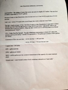
1. “CFS” means “cubic feet per second.” This is a “RATE of discharge representing a volume of 1 cubic foot passing a given point during 1 second of time.”
2. An ACRE FOOT, the second term, is a VOLUME of water “that covers one acre at a depth of 12 inches.”
Obviously, higher CFS numbers translate into higher ACRE FEET numbers. But what do these numbers mean?
Easily put, for the St Lucie River, none of it, if dumping, is “good.”
For reference, during the “Lost Summer” of 2013, the highest CFS discharge I heard reported was up to 7000 cfs during the very height of the releases. Usually, it was lower,May-October, ranging from about 200 to 4000 cfs.
Now acre feet.
According to Robert Johnson, Director of South Florida Natural Resouces Center at Everglades Nation Park, who presented at the Everglades Coalition last week, —-NOT during 2013, but ON AVERAGE, “800,000 acre feet of water from Lake Okeechobee flows per year towards the southern estuaries.”
Mind you, the larger Caloosahatchee on the west coast takes the majority of that water. I am no expert, but I think I can safely say, they usually take closer to 2/3 the water the water the St Lucie does.
Can you do the math? I need my calculator! AG! Over 200,000 Acre feet for sure going towards the St Lucie and over 500,000 going towards the Caloosahatchee.
In the end, no matter what, the numbers are staggering! Truly mind-blowing. 800,000 acre feet, would need 800,000 acres to hold 800,000 acre feet of water at 12 inches. The EAA is 700,000 acres….
So, let’s learn to speak the language and communicate our wishes! And take a look at the handout below. It’s a good one!

_______________________________
After I wrote the above blog, Mark Perry of Florida Oceanographic contacted me, so I wrote another post relating to the above post. It is here should you wish to read it: (http://jacquithurlowlippisch.com/2015/01/15/water-water-everywhere-st-lucie-riverindian-river-lagoon/)
TYVM Jacqui. I attended the session where that handout was supplied and to better help explain, the 23% reduction in the amount of discharges that CEPP/CERP to the East Coast represents about 400,000 Acre Feet. That leaves 1.2 million Acre Feet of water to still be discharged. How much is 23%? About 44 days of the rainy season… Or discharges stopping on September 1st after running since May 1st.
This is WHY One Florida has continued to locate viable sites for storage of the other 77%. To us, STOP THE DISCHARGES means all the discharges…..
Including the 100,000 Acre Feet referred to as local runoff. While people listen to conversations about what percentages of that local runoff is AG or other sources, that hardly lessens the impact.
If that water were properly cleaned, it could be sent to the Lake to comingle and head south. After all, if would only raise the Lake 1 inch.
There seems to be push back at these ideas and one must wonder….”Do they really want those discharges stopped, or just our ideas?”
Good comments Don. I did not get to attend this session; Ed brought me the handout as he attended. For me it was an excellent simple handout. Your numbers explanation is much deeper than I am capable but is well said. I just want storage-as much as possible—everywhere possible. 🙂 Good to see you at the Everglades Coalition Conference.
Thanks for your educational posts. As a new resident in the area (3 years) I have been doing a lot of reading to educate myself on our water issues and find your blog quite helpful. Keep up the good work- it is greatly appreciated. Here’s a link to a publication on sfwmd’s website that I stumbled across recently. It includes a good glossary of terms and also a lot of information on the canals and structures on the various watersheds. Link: http://www.sfwmd.gov/portal/page/portal/xrepository/sfwmd_repository_pdf/canalssfl_appendixa-c.pdf
Dear Dave, Thank you so much. That is a pretty technical document and very good! Thanks for sharing and I’m sure others will use as well. Appreciate your comment and thank you for reading my blog!