In my readings, I come across quite a few interesting old maps.
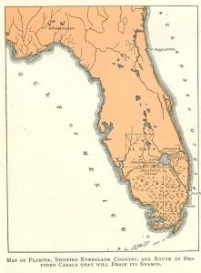
The one above, is most unusual because it is labeled “Jensen” rather than “Stuart” as to where the canal draining Lake Okeechobee was to go in the early 1900s.
I found the map from a write-up that is part of the “Digital History Project.” This piece was originally published by A. B Clark in 1907. Here is the link for the full write-up in case you are interested: (http://www.digitalhistoryproject.com/2011/08/draining-florida-everglades-lake.html)
When reading such work form the late 1800s and early 1900s, it mind-boggling to think of how our perceptions have changed and how we as a society are constantly dealing with the decisions of our ancestors, who helped get us here, albeit today, possibly considered “politically incorrect.”
Take for instance the Swamp Land Act of 1885.
Let’s read about its encyclopedic history:
“The Swamp Land Act of 1850 was US federal law and essentially provided a mechanism for transferring title to federally owned swampland to private parties agreeing to drain the land and turn it to productive, presumably agricultural, use. This gave broke states like Florida an opportunity to make money and for people to buy very cheap land and make it “productive…”
This law was primarily aimed at the development of Florida’s Everglades, and transferring some 20 million acres (31,000 sq mi) of land in the Everglades to the State of Florida for this purpose.
The law also had application outside Florida, and spurred drainage and development in many areas of the United States, including areas around Indiana’s Kankakee River, Michigan’s Lake St. Clair’s shores, and elsewhere, and encouraged settlement by immigrants arriving in the United States.
Much later the law was considered to have been ecologically problematic. Many of its provisions were in time reversed by the wetland protection acts in 1972 and later legislation, but its historical effects on U.S. development and settlement patterns remain.”
I was born in 1964, so wet land protection is ingrained in me. Nonetheless my great grandparents were taught to think of wetlands or swamps as useless….
When reading through the piece by A.B Clark, he lists the counties as Lee, Desoto, Dade and St Lucie as the primary ones to be drained. One must note of course that the county lines were different then. For instance my parents live in Indialucie in Sewall’s Point and my mother created a sign and nailed it to a cabbage palm. The sign reads: “Brevard-Dade”
“St. Lucie-Palm Beach.” The sign represents the county line between the counties. St. Lucie was created in 1905 and Palm Beach in 1909.
We have gotten quite a kick out showing guests this sign over the years!
Old stuff is cool.
Here are some old public Florida county line maps. They are fascinating to look at too. The lines have gone back and forth and changed over the years.
Wonder what they will read in the future with rising seas, higher populations, and wetlands now known for their importance to water supply and water quality?


They say “the only constant is change.” How true this is….
______________________________
Swampland Act, Wikipedia: (http://en.wikipedia.org/wiki/Swamp_Land_Act_of_1850)
UF IFAS Florida’s wetland protection history: (http://soils.ifas.ufl.edu/wetlandextension/protect/legislation.htm)
Beautiful maps!
I love those too. Thanks!
Woheг schoepft ihr die Ideen fuer die Webseiten, sie sind extrem οkay
geschrieben 🙂
Vielen Dank. Mein Herz.